Embed Size (px)
Citation preview
GLOSSARY WHAT THE JARGON WORDS MEANCommunity PlanCommunity plans are produced through collaborationbetween local residents and representatives of public,voluntary and private sector organisations andbusinesses. Community plans seek to influence andinform public bodies, organisations and other serviceproviders about the priorities for people in the plan area.
Cornwall Local PlanA plan setting out the spatial vision and strategicobjectives of the planning framework for Cornwall.Our Neighbourhood Plan must conform to thestrategic principles and polices of the Local Plan.
Habitats Regulation AssessmentThis is a requirement for plans that are likely to leadto significant effects on European sites of natureconservation importance.
Homeworking This is defined as a householder and one or twoother people working in a way which does notintrude on neighbouring properties adversely, forinstance by increasing traffic, receiving largevehicles, generating noise of odours, or by workinganti-social hours.Local Planning AuthorityA local planning authority is the local authority orcouncil that is empowered by law to exercisestatutory town planning functions for a particulararea of the United Kingdom
Localism ActThe Localism Act 2011 includes five key measuresthat underpin the government’s approach todecentralisation. • Community rights • Neighbourhood planning • Housing • General power of competence • Empowering cities and other local areas National Planning Policy Framework (NPPF)The NPPF sets out the planning policies for England.This was a key part of the reforms to make theplanning system less complex and more accessible,and to promote sustainable growth. The Frameworksets out planning policies for England and how theyare expected to be applied. It provides guidance forlocal planning authorities and decision-takers, bothin drawing up plans and making decisions aboutplanning applications.
Neighbourhood AreaA neighbourhood area has to be formally designatedfor a neighbourhood plan or order to be produced
Neighbourhood PlansNew type of plans introduced by the Localism Act.They will be prepared by town/parish councils, orconstituted Neighbourhood Forums, and developdetailed planning policies for a town/parish (or partof them) in general conformity with the council’sLocal Plan or LDF.
Planning Advisory ServiceThe Planning Advisory Service helps councilsprovide faster, fairer, more efficient and better qualityplanning services. See www.pas.gov.uk
Qualifying BodyThis can be described as: a parish council,organisation or body designated as aneighbourhood forum, authorised to act in relation toa neighbourhood area for the purposes of aneighbourhood development plan
Statement of Community InvolvementA document setting out how the public have beeninvolved at every stage in the production of the LocalPlan, Neighbourhood Plan, or major Planningapplication.
Statutory ConsulteesStatutory consultees for the purposes ofneighbourhood planning are defined within theNeighbourhood Planning (General) Regulations
Steering GroupA steering group is a committee of individuals madeup of community representatives who will driveforward the neighbourhood planning project onbehalf of the town or parish council.
Strategic Environmental AssessmentAn assessment of certain plans and policies on theenvironment.
Sustainability AppraisalAn appraisal of the impacts of policies andproposals on economic, social and environmentalissues. This can also be a useful tool to assistselecting suitable sites for development.
Sustainability Appraisal (includingEnvironmental Appraisal)An appraisal of the economic, environmental andsocial effects of a plan from the outset of thepreparation process to allow decisions to be madethat accord with sustainable development.(Environmental appraisal covers only environmentalimpacts)
Town and Country Planning Act 1990The Town and Country Planning Act 1990 is an actof the British Parliament regulating the developmentof land in England and Wales.
91
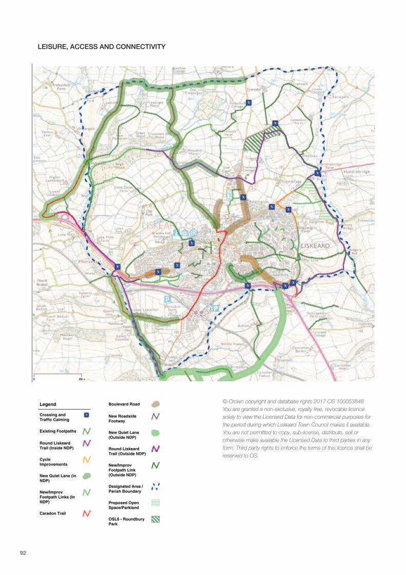
92
Legend
Crossing andTraffic Calming
Existing Footpaths
Round LiskeardTrail (Inside NDP)
CycleImprovements
New Quiet Lane (inNDP)
New/ImprovFootpath Links (InNDP)
Caradon Trail
Boulevard Road
New RoadsideFootway
New Quiet Lane(Outside NDP)
Round LiskeardTrail (Outside NDP)
New/ImprovFootpath Link(Outside NDP)
Designated Area /Parish Boundary
Proposed OpenSpace/Parkland
OSL6 - RoundburyPark
LEISURE, ACCESS AND CONNECTIVITY
© Crown copyright and database rights 2017 OS 100053848You are granted a non-exclusive, royalty free, revocable licencesolely to view the Licensed Data for non-commercial purposes forthe period during which Liskeard Town Council makes it available.You are not permitted to copy, sub-license, distribute, sell orotherwise make available the Licensed Data to third parties in anyform. Third party rights to enforce the terms of this licence shall bereserved to OS.
Date Created: 2-8-2017 | Map Centre (Easting/Northing): 225025 / 64526 | Scale: 1:10000 | ' Crown copyright and database right. All rights reserved (100053848) 2017
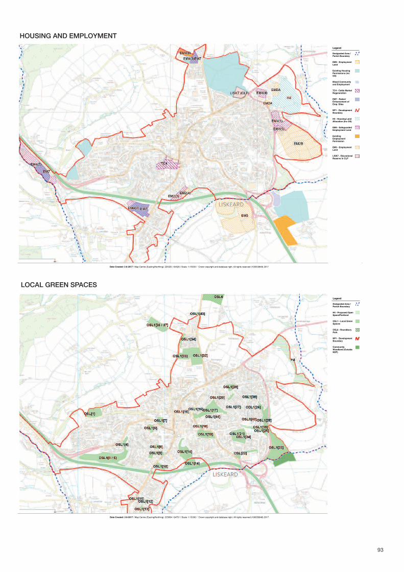
Legend
Designated Area /Parish Boundary
EM2 - EmploymentLand
Existing HousingPermissions (incOS)
Mixed Communityand Employment
TC4 - Cattle MarketRegeneration
EM7 - Redev/Enhancement ofEmp. Sites
NP1 - DevelopmentBoundary
H4 - Housing LandAllocation (Inc OS)
EM4 - SafeguardedEmployment Land
ExistingEmploymentPermission
EM3 - EmploymentLand
LISK7 - EducationalReserve in CLP
HOUSING AND EMPLOYMENT
Date Created: 2-8-2017 | Map Centre (Easting/Northing): 225094 / 64751 | Scale: 1:10000 | ' Crown copyright and database right. All rights reserved (100053848) 2017
Legend
Designated Area /Parish Boundary
H4 - Proposed OpenSpace/Parkland
OSL1 - Local GreenSpaces
OSL6 - RoundburyPark
NP1 - DevelopmentBoundary
CommunityWoodland (OutsideNDP)
LOCAL GREEN SPACES
93
5
5
94
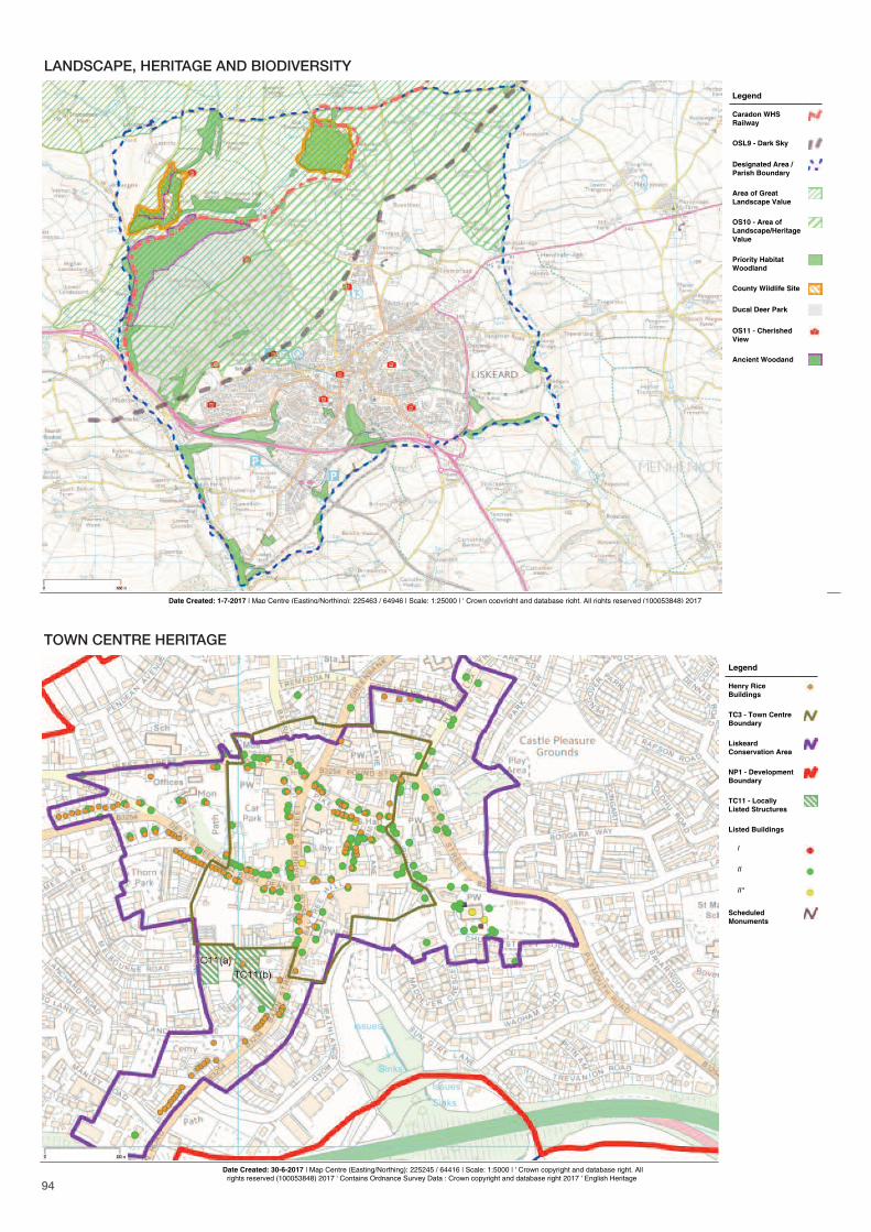
Date Created: 1-7-2017 | Map Centre (Easting/Northing): 225463 / 64946 | Scale: 1:25000 | ' Crown copyright and database right. All rights reserved (100053848) 2017
Legend
Caradon WHSRailway
OSL9 - Dark Sky
Designated Area /Parish Boundary
Area of GreatLandscape Value
OS10 - Area ofLandscape/HeritageValue
Priority HabitatWoodland
County Wildlife Site
Ducal Deer Park
OS11 - CherishedView
Ancient Woodand
LANDSCAPE, HERITAGE AND BIODIVERSITY
Date Created: 30-6-2017 | Map Centre (Easting/Northing): 225245 / 64416 | Scale: 1:5000 | ' Crown copyright and database right. Allrights reserved (100053848) 2017 ' Contains Ordnance Survey Data : Crown copyright and database right 2017 ' English Heritage
Legend
Henry RiceBuildings
TC3 - Town CentreBoundary
LiskeardConservation Area
NP1 - DevelopmentBoundary
TC11 - LocallyListed Structures
Listed Buildings
I
II
II*
ScheduledMonuments
TOWN CENTRE HERITAGE

95

For more information please visit: www.planliskeard.co.uk or contact: Town Clerk, Liskeard Town Council, 3-5 West Street, Liskeard, Cornwall, PL14 6BW
Tel: 01579 345407