Embed Size (px)
Citation preview
1
1
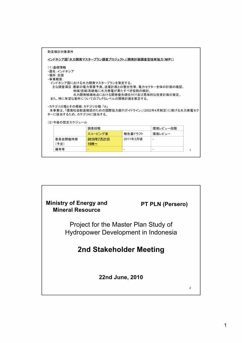
M/P
/ /
FS
A2002 4
A
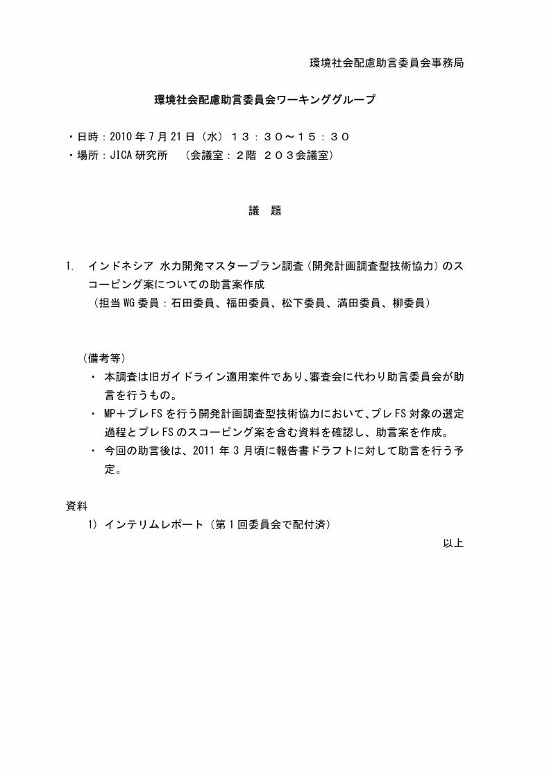
---
-2011 32010 7 2115
2
Project for the Master Plan Study of Hydropower Development in Indonesia
2nd Stakeholder Meeting
22nd June, 2010
Ministry of Energy and Mineral Resource
PT PLN (Persero)
2
3
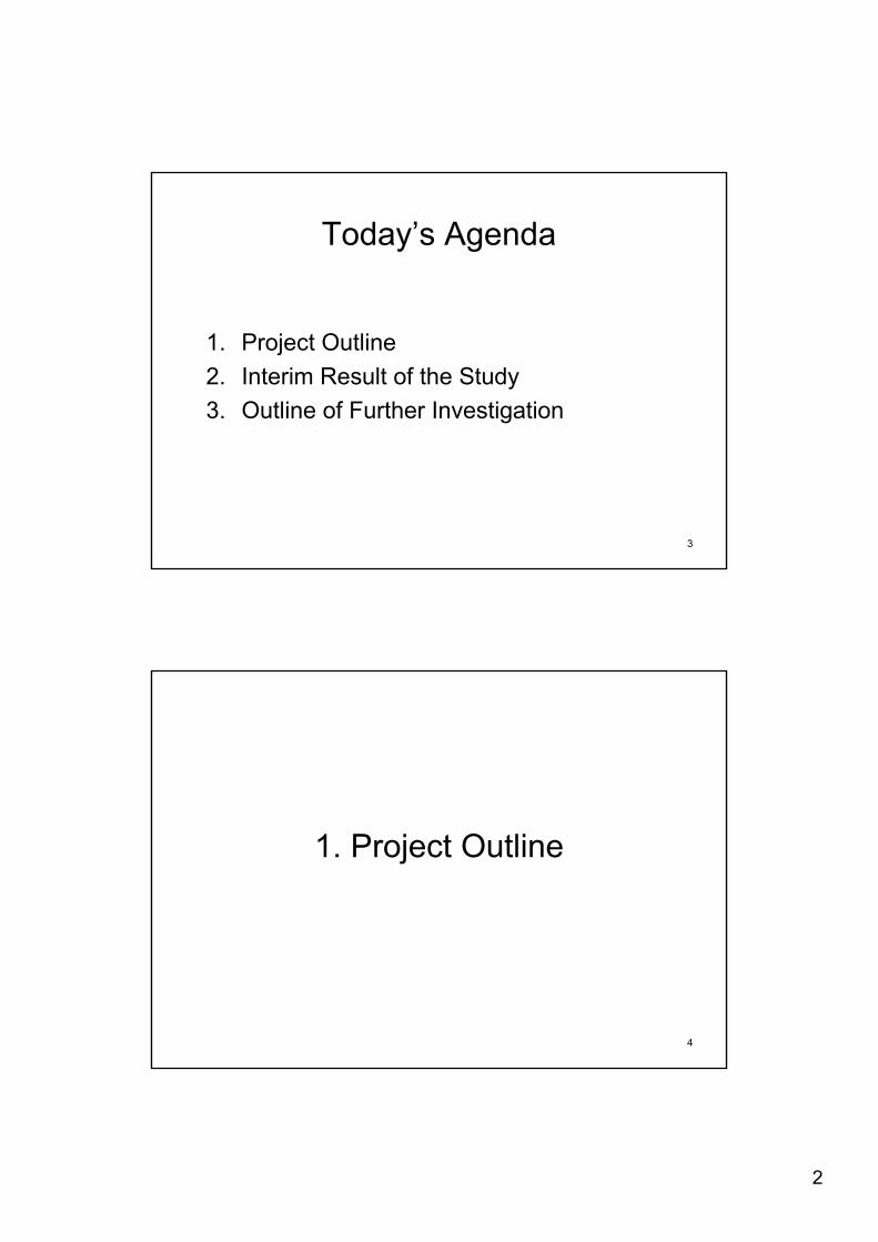
Today’s Agenda
1. Project Outline2. Interim Result of the Study3. Outline of Further Investigation
4
1. Project Outline
3
5
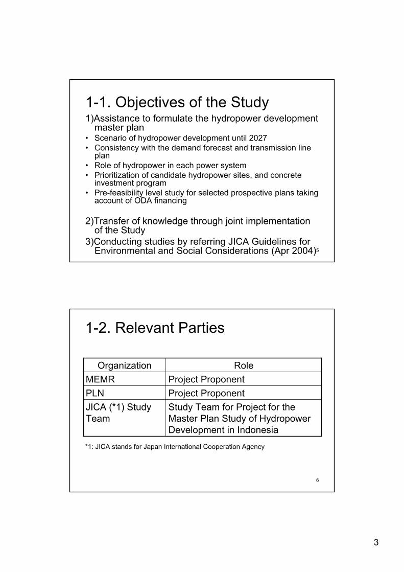
1-1. Objectives of the Study1)Assistance to formulate the hydropower development
master plan• Scenario of hydropower development until 2027• Consistency with the demand forecast and transmission line
plan• Role of hydropower in each power system• Prioritization of candidate hydropower sites, and concrete
investment program• Pre-feasibility level study for selected prospective plans taking
account of ODA financing
2)Transfer of knowledge through joint implementation of the Study
3)Conducting studies by referring JICA Guidelines for Environmental and Social Considerations (Apr 2004)
6
1-2. Relevant Parties
Study Team for Project for the Master Plan Study of Hydropower Development in Indonesia
JICA (*1) Study Team
Project ProponentPLNProject ProponentMEMR
RoleOrganization
*1: JICA stands for Japan International Cooperation Agency
4
7
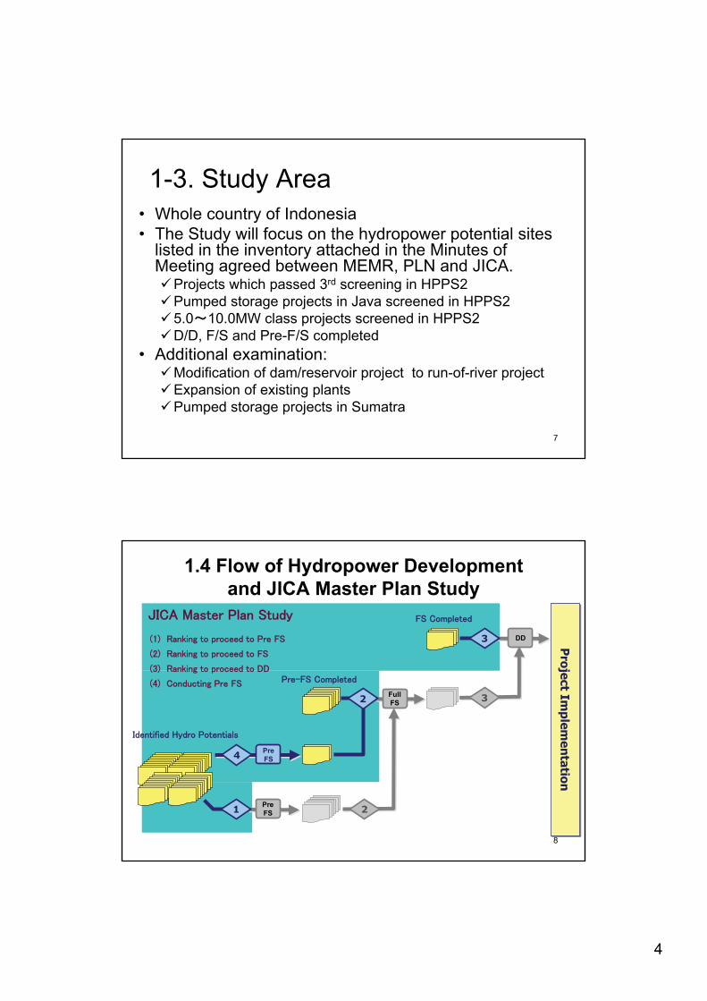
1-3. Study Area• Whole country of Indonesia• The Study will focus on the hydropower potential sites
listed in the inventory attached in the Minutes of Meeting agreed between MEMR, PLN and JICA.
Projects which passed 3rd screening in HPPS2Pumped storage projects in Java screened in HPPS25.0 10.0MW class projects screened in HPPS2D/D, F/S and Pre-F/S completed
• Additional examination: Modification of dam/reservoir project to run-of-river projectExpansion of existing plantsPumped storage projects in Sumatra
8
Project Im
plemen
tationP
roject Implem
entation
1.4 Flow of Hydropower Developmentand JICA Master Plan Study
FullFS
2
2
3
1Pre FS
3
4 Pre FS
DD
5
96
Hom
e W
ork
Fiel
d Su
rvey
1No.
Wor
k Ite
ms
Stake HolderMeeting
16 17 18 19
Dec May JunMayMar AprAug Sep Oct Nov
14 1510 11 12 13
FY2009
208 9
Jan Feb
74 52 3
Mar
Stage
Fiscal Year FY2010 FY2011
2011Dec FebJan
Reports
YearJunAprMonth
2009 2010JulJul
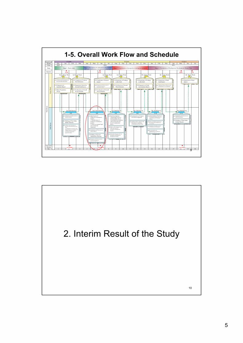
Home Prep. Work 3rd Home Work
Stage 1: Basic study Stage 2: Data analysis for Hydropower DevelopmentM/P and Identification of prospective hydropower
Stage 4: Formulation of Hydropower Development Master Plan
Ic/R Df/R F/R
1
Collection and Examination ofRelevant Data/information
(1)
Preparation ofInception Report
(2)
Other PreparatoryWorks
(3)
1st Field Survey
2
Explanation and Discussion onInception Report
(1)
Holding of First StakeHolder Meeting
(2)
Collection and Examination ofNecessary Data/information for theStudy
Confirmation of necessity of theStudy/hydropower development andcandidate hydropower projects
Selection of prioritizedregions/river basins
(3)
1st Home Work
3
Compilation of CollectedData/information
(1)
Preparatory Works forSecond Field Survey
(2)
Verification of OverallWork Schedule
(3)
2nd Field Survey
4
Identification ofProspective HydropowerProjects
Identification ofprospective hydropowerprojects
Study on required legaland institutionalframework
(1)
Explanation and Discussion onInterim Report
(2)
Holding of SecondStakeholder Meeting
(3)
Preparation of Field Investigationsfor Selected ProspectiveHydropower Projects
(4)
2nd Home Work
5
Finalization of InterimReport
(1)
Preparation of Field Investigationsfor Selected ProspectiveHydropower Projects
(2)
Verification of OverallWork Schedule
(3)
Stage 3: Examination of prospective hydropower projects
3rd Field Survey
6
Field InvestigationsHydrological SurveyTopographic SurveyGeological InvestigationEnvironmental and
Social ConsiderationSurvey
(1)
Study on Development Type,Scale and Layout ofProspective HydropowerProjects
(2)
Preliminary Design and CostEstimation of ProspectiveHydropower Project
(3)
7
Organizing of Findingsin the Field
(1)
Verification of OverallWork Schedule
(2)
It/R
4th Field Survey
8
Confirmation on Progressof Field Investigations
(1)
Additional Data Collection andPreparation for Updating/Formulating the Master Plan
(2)
4th Home Work
9
Organizing of Findingsin the Field
(1)
Preparation of FieldInvestigation Report
(2)
5th Field Survey
10
Update/formulation of HydropowerDevelopment Planning in the LongTerm Generation DevelopmentPlanning
(1)
Study on Installation Schedule andDeveloping Scale of HydropowerDevelopment
(2)
Organizing and Analysis of Issuesfor Hydropower Development
(3)
Recommendations forImplementation of ProspectiveHydropower Projects
(4)
5th Home Work
11
Preparation of DraftFinal Report
(1)
Additional Data Collection andArrangement for Examination
(2)
6th Field Survey
12
Explanation and Discussion onDraft Final Report
(1)
Holding of Third StakeHolder Meeting
(2)
6th Home Work
13
Preparation of FinalReport
(1)
1st SHM 2nd SHM 3rd SHM
1-5. Overall Work Flow and Schedule
10
2. Interim Result of the Study
6
11
• Evaluating degree of development difficulty due to environmental aspects by indicators
• Evaluating project economy by simplified cost-benefit analysis
• Screenings in two stages1st screening projects for conducting site reconnaissance survey2nd screening projects for conducting pre FS
2-1. Classification and Screening for Selecting Pre-FS Sites
12
A B C D
Definition With nothing special difficulties
Although certain difficulties are expected, the solution could be found.
The solution for the constraints is considered as difficult.
The solution for the constraints is considered as very difficult.
Forest type NA Production Forest(HP), and Conversion Forest(HK)
Protection Forest (HL)
Nature Forest Reserve and Tourism/Recreation Forest (Hutan Suaka Alam:HSA)
Resettlement 0~50 HH 50~400 HH 400~1000 HH 1000~HH Reservoir Area
0~100 ha 100~1000 ha 1000~10,000 ha
10,000~ ha
Rank
Items
2-2. Degree of Difficulty due to Environmental Aspects
7
13
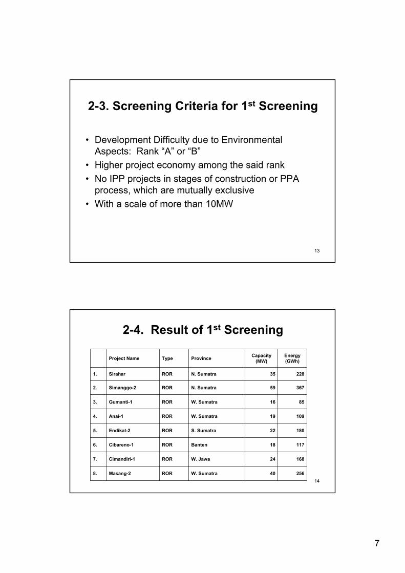
• Development Difficulty due to Environmental Aspects: Rank “A” or “B”
• Higher project economy among the said rank• No IPP projects in stages of construction or PPA
process, which are mutually exclusive• With a scale of more than 10MW
2-3. Screening Criteria for 1st Screening
1425640W. SumatraRORMasang-28.
16824W. JawaRORCimandiri-17.
11718BantenRORCibareno-16.
18022S. SumatraROREndikat-25.
10919W. SumatraRORAnai-14.
8516W. SumatraRORGumanti-13.
36759N. SumatraRORSimanggo-22.
22835N. SumatraRORSirahar1.
Energy (GWh)
Capacity (MW)ProvinceTypeProject Name
2-4. Result of 1st Screening
8
15
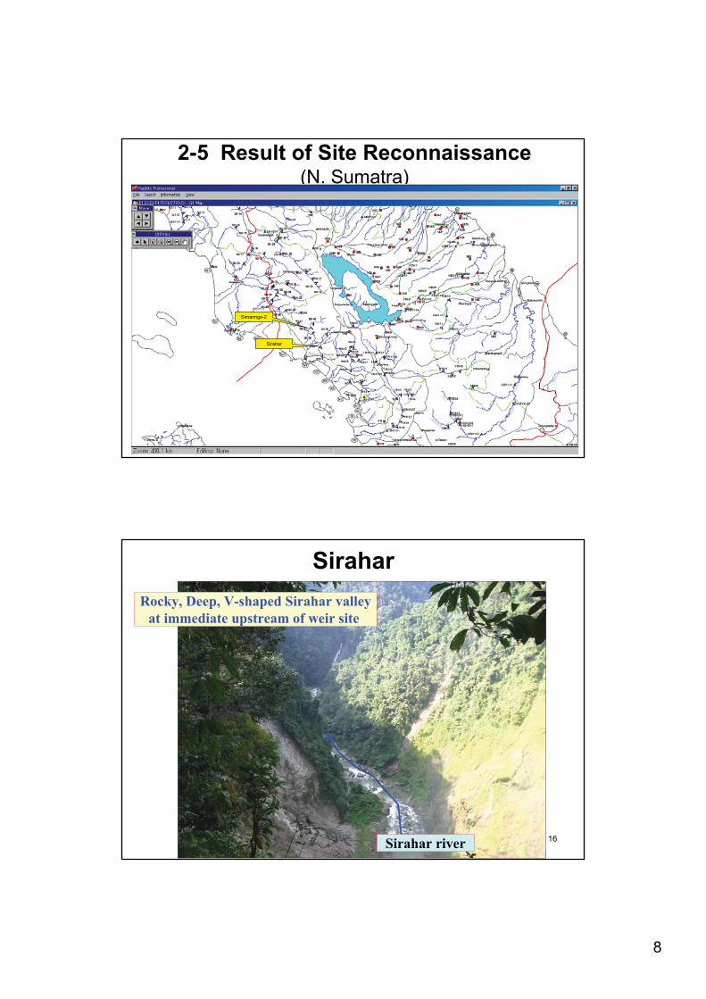
2-5 Result of Site Reconnaissance(N. Sumatra)
Simanngo-2
Sirahar
16
Sirahar
Sirahar river
Rocky, Deep, V-shaped Sirahar valley at immediate upstream of weir site.
9
17
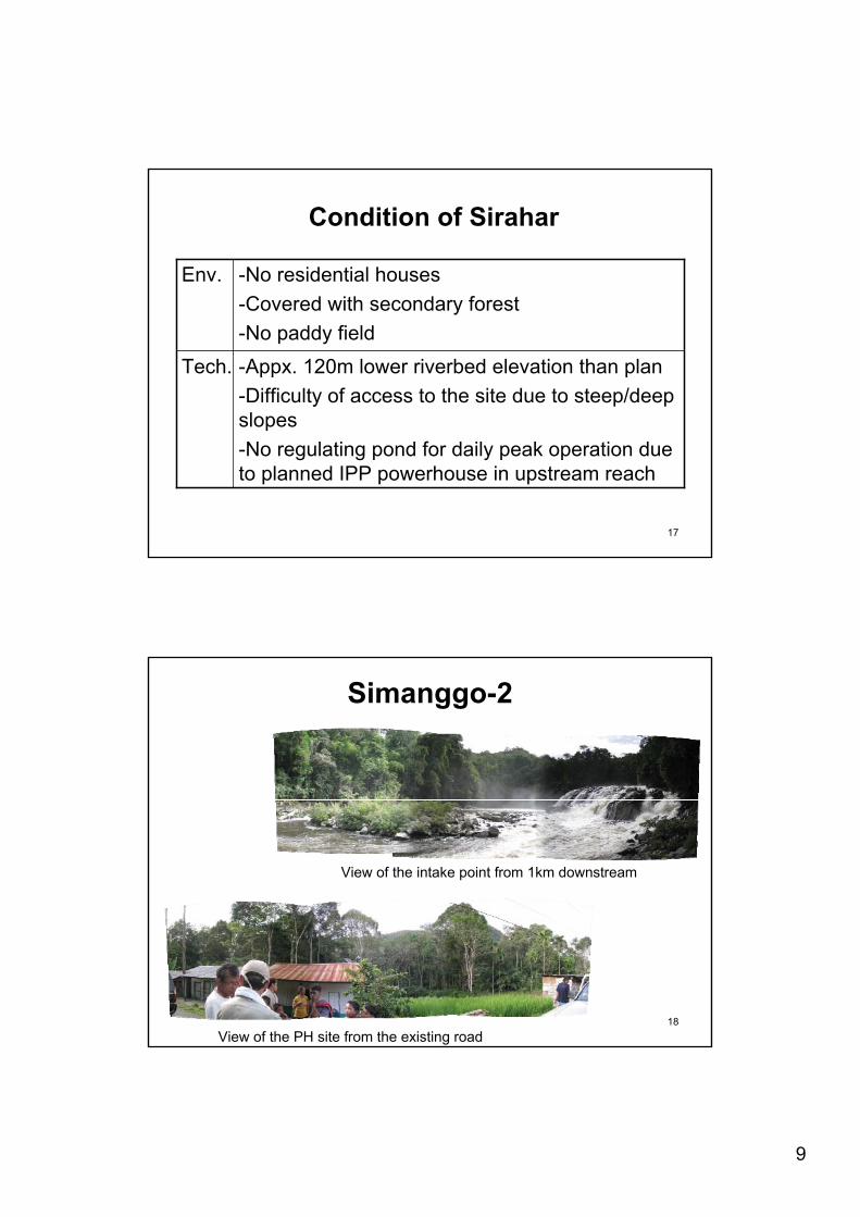
Condition of Sirahar
-Appx. 120m lower riverbed elevation than plan-Difficulty of access to the site due to steep/deep slopes-No regulating pond for daily peak operation due to planned IPP powerhouse in upstream reach
Tech.
-No residential houses-Covered with secondary forest-No paddy field
Env.
18
Simanggo-2
View of the intake point from 1km downstream
View of the PH site from the existing road
10
19
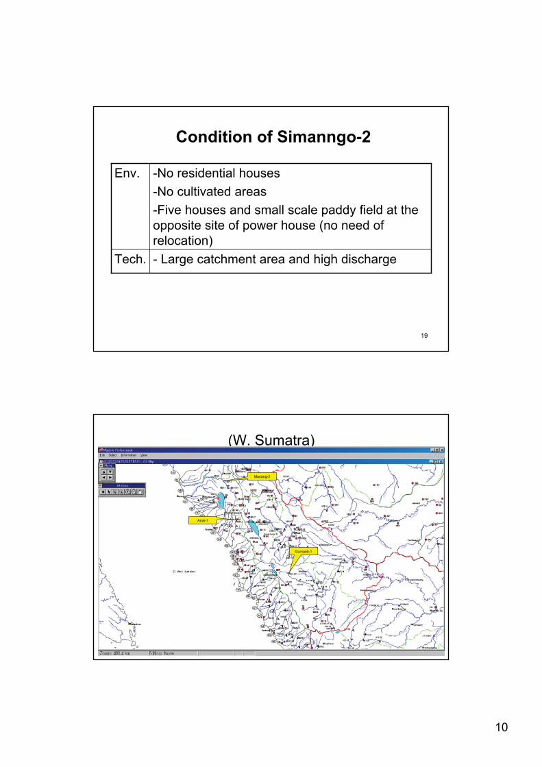
Condition of Simanngo-2
- Large catchment area and high dischargeTech.
-No residential houses-No cultivated areas-Five houses and small scale paddy field at the opposite site of power house (no need of relocation)
Env.
20
(W. Sumatra)
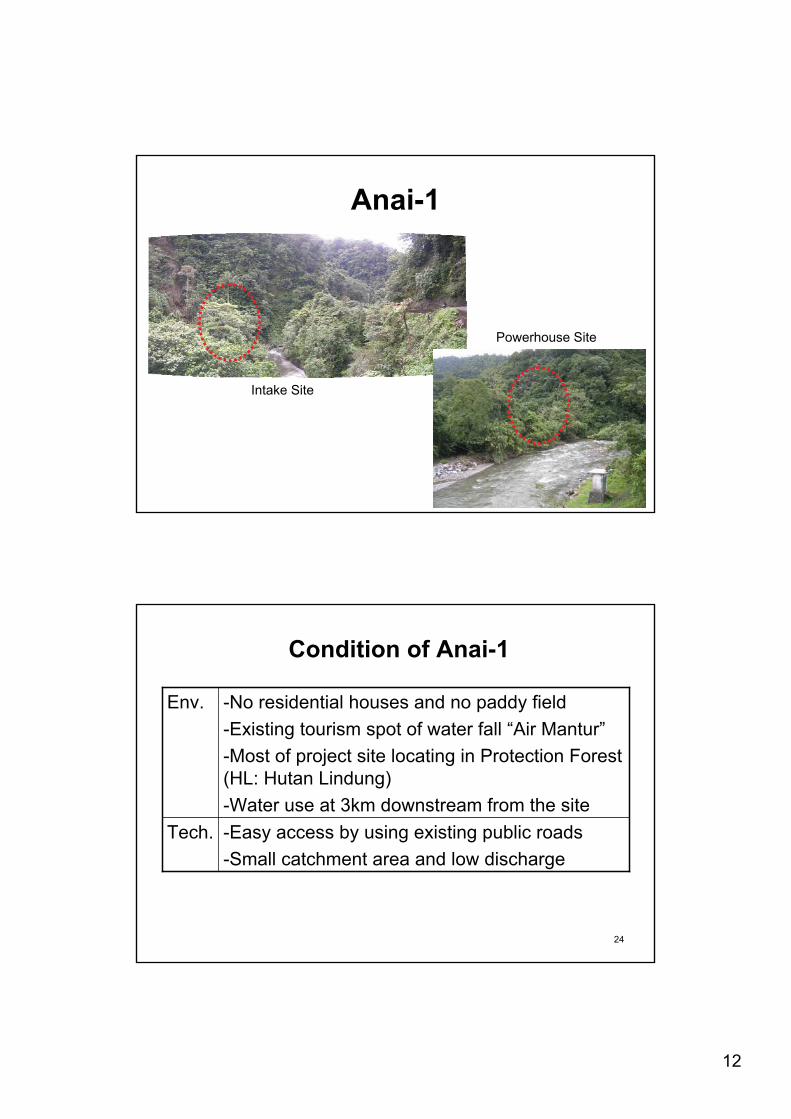
Anai-1
Gumanti-1
Masang-2
11
21
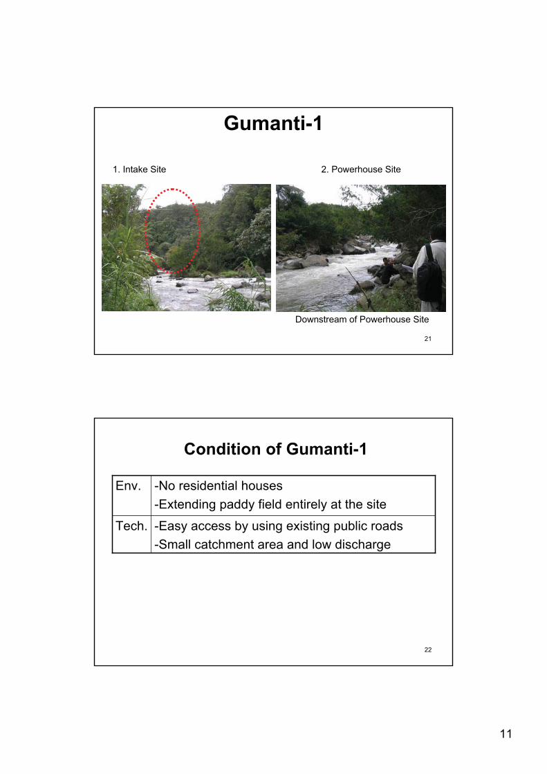
Gumanti-1
1. Intake Site
Downstream of Powerhouse Site
2. Powerhouse Site
22
Condition of Gumanti-1
-Easy access by using existing public roads-Small catchment area and low discharge
Tech.
-No residential houses-Extending paddy field entirely at the site
Env.
12
23
Anai-1
Intake Site
Powerhouse Site
24
Condition of Anai-1
-Easy access by using existing public roads-Small catchment area and low discharge
Tech.
-No residential houses and no paddy field-Existing tourism spot of water fall “Air Mantur”-Most of project site locating in Protection Forest (HL: Hutan Lindung)-Water use at 3km downstream from the site
Env.
13
25
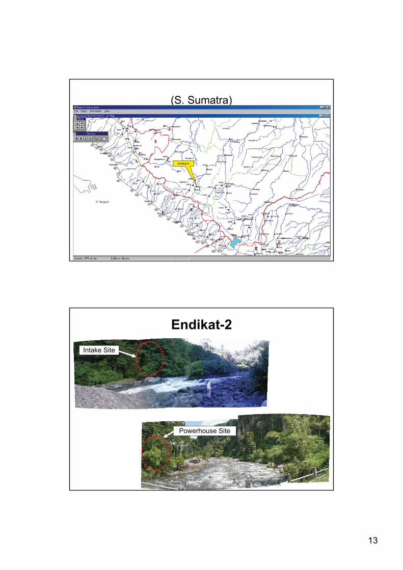
(S. Sumatra)
Endikat-2
26
Endikat-2Intake Site
Powerhouse Site
14
27
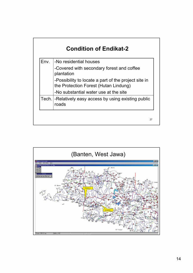
Condition of Endikat-2
-Relatively easy access by using existing public roads
Tech.
-No residential houses-Covered with secondary forest and coffee plantation-Possibility to locate a part of the project site in the Protection Forest (Hutan Lindung)-No substantial water use at the site
Env.
28
(Banten, West Jawa)
Cibareno-1
Cimandiri-1
15
29
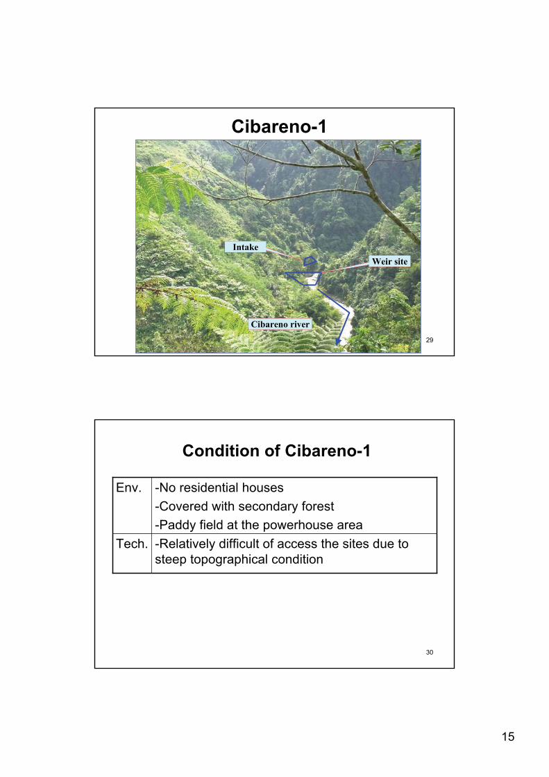
Cibareno-1
Intake Weir site
Cibareno river
30
Condition of Cibareno-1
-Relatively difficult of access the sites due to steep topographical condition
Tech.
-No residential houses-Covered with secondary forest -Paddy field at the powerhouse area
Env.
16
31
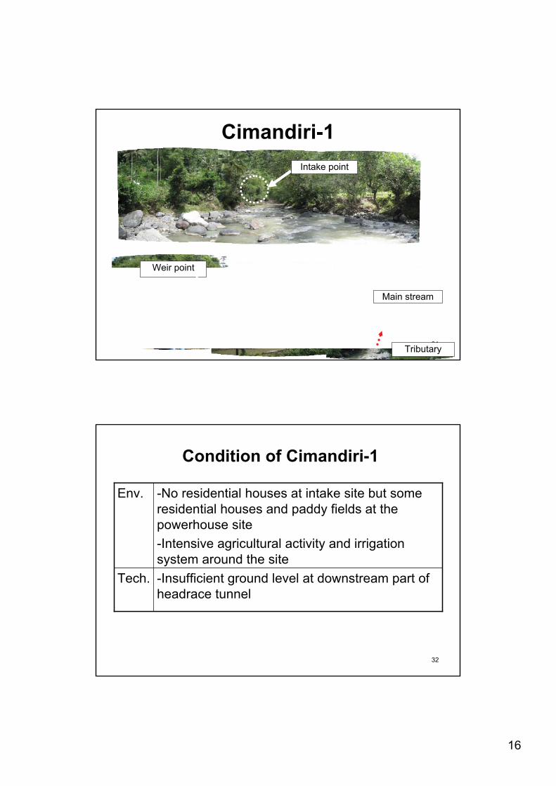
Cimandiri-1Intake point
Tributary
Main stream
Weir point
32
Condition of Cimandiri-1
-Insufficient ground level at downstream part of headrace tunnel
Tech.
-No residential houses at intake site but some residential houses and paddy fields at the powerhouse site-Intensive agricultural activity and irrigation system around the site
Env.
17
33
(W. Sumatra)
Anai-1
Gumanti-1
Masang-2
34
Masang-2
View of the power house point from the 2km downstream
Rubber Plant
Durian Tree
18
35
Masang-2
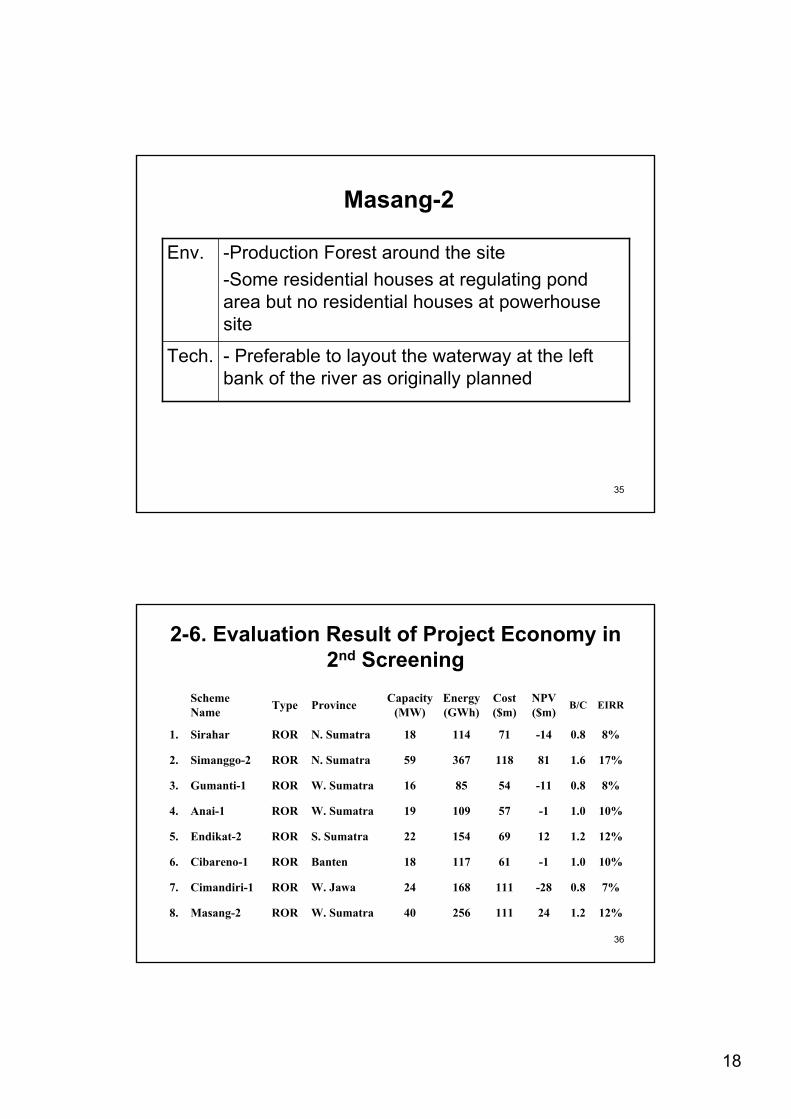
- Preferable to layout the waterway at the left bank of the river as originally planned
Tech.
-Production Forest around the site-Some residential houses at regulating pond area but no residential houses at powerhouse site
Env.
36
2-6. Evaluation Result of Project Economy in 2nd Screening
12%1.22411125640W. SumatraRORMasang-28.
7%0.8-2811116824W. JawaRORCimandiri-17.
10%1.0-16111718BantenRORCibareno-16.
12%1.2126915422S. SumatraROREndikat-25.
10%1.0-15710919W. SumatraRORAnai-14.
8%0.8-11548516W. SumatraRORGumanti-13.
17%1.68111836759N. SumatraRORSimanggo-22.
8%0.8-147111418N. SumatraRORSirahar1.
EIRRB/CNPV($m)
Cost($m)
Energy(GWh)
Capacity(MW)ProvinceTypeScheme
Name
19
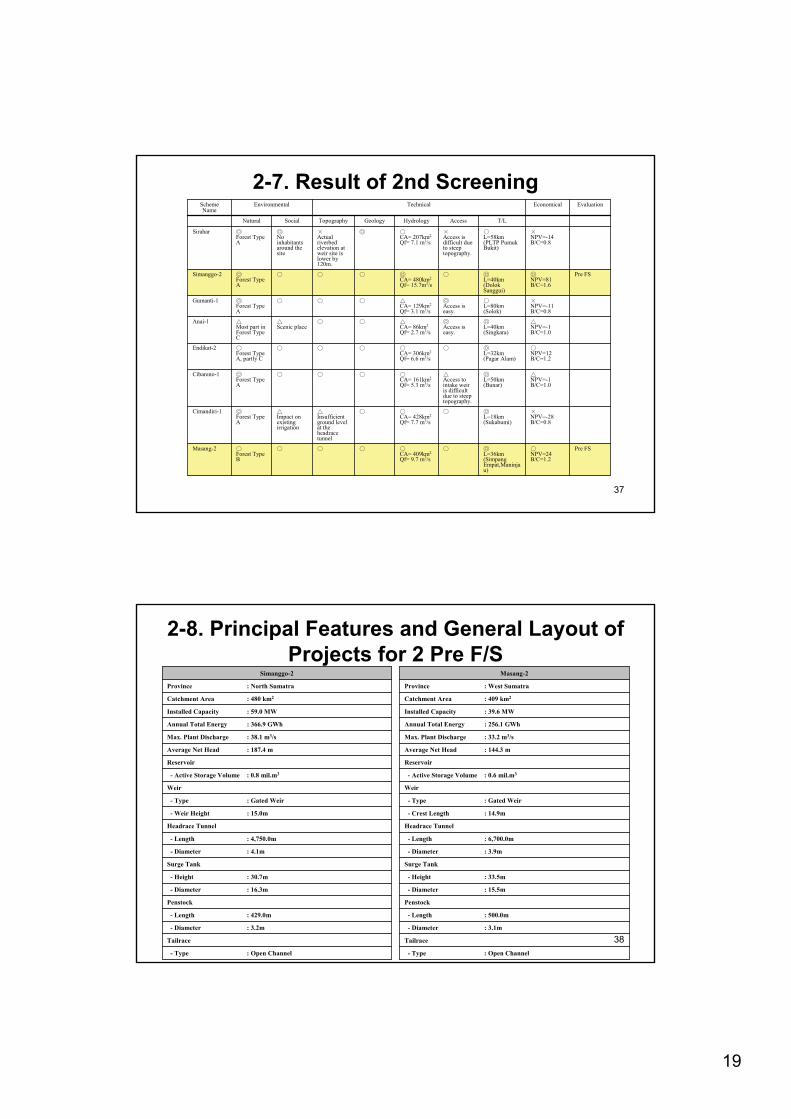
37
Pre FSNPV=24 B/C=1.2
L=36km(SimpangEmpat,Maninjau)
CA= 409km2
Qf= 9.7 m3/sForest Type B
Masang-2
NPV=-28B/C=0.8
L=18km(Sukabumi)
CA= 428km2
Qf= 7.7 m3/sInsufficient ground level at the headrace tunnel
Impact on existing irrigation
Forest Type A
Cimandiri-1
NPV=-1B/C=1.0
L=50km(Bunar)
Access to intake weir is difficult due to steep topography.
CA= 161km2
Qf= 5.3 m3/sForest Type A
Cibareno-1
NPV=12 B/C=1.2
L=32km(Pagar Alam)
CA= 306km2
Qf= 6.6 m3/sForest Type A, partly C
Endikat-2
NPV=-1 B/C=1.0
L=40km(Singkara)
Access is easy.
CA= 86km2
Qf= 2.7 m3/sScenic placeMost part in
Forest Type C
Anai-1
NPV=-11 B/C=0.8
L=80km(Solok)
Access is easy.
CA= 129km2
Qf= 3.1 m3/sForest Type A
Gumanti-1
Pre FSNPV=81 B/C=1.6
L=40km(DolokSanggui)
CA= 480km2
Qf= 15.7m3/sForest Type A
Simanggo-2
NPV=-14B/C=0.8
L=58km(PLTP PumukBukit)
Access is difficult due to steep topography.
CA= 207km2
Qf= 7.1 m3/sActual riverbed elevation at weir site is lower by 120m.
No inhabitants around the site
Forest Type A
Sirahar
T/LAccessHydrologyGeologyTopographySocialNatural
EvaluationEconomicalTechnical EnvironmentalScheme Name
2-7. Result of 2nd Screening
38
2-8. Principal Features and General Layout of Projects for 2 Pre F/S
- Type : Open Channel
Tailrace
- Diameter : 3.2m
- Length : 429.0m
Penstock
- Diameter : 16.3m
- Height : 30.7m
Surge Tank
- Diameter : 4.1m
- Length : 4,750.0m
Headrace Tunnel
- Weir Height : 15.0m
- Type : Gated Weir
Weir
- Active Storage Volume : 0.8 mil.m3
Reservoir
Average Net Head : 187.4 m
Max. Plant Discharge : 38.1 m3/s
Annual Total Energy : 366.9 GWh
Installed Capacity : 59.0 MW
Catchment Area : 480 km2
Province : North Sumatra
Simanggo-2
- Type : Open Channel
Tailrace
- Diameter : 3.1m
- Length : 500.0m
Penstock
- Diameter : 15.5m
- Height : 33.5m
Surge Tank
- Diameter : 3.9m
- Length : 6,700.0m
Headrace Tunnel
- Crest Length : 14.9m
- Type : Gated Weir
Weir
- Active Storage Volume : 0.6 mil.m3
Reservoir
Average Net Head : 144.3 m
Max. Plant Discharge : 33.2 m3/s
Annual Total Energy : 256.1 GWh
Installed Capacity : 39.6 MW
Catchment Area : 409 km2
Province : West Sumatra
Masang-2
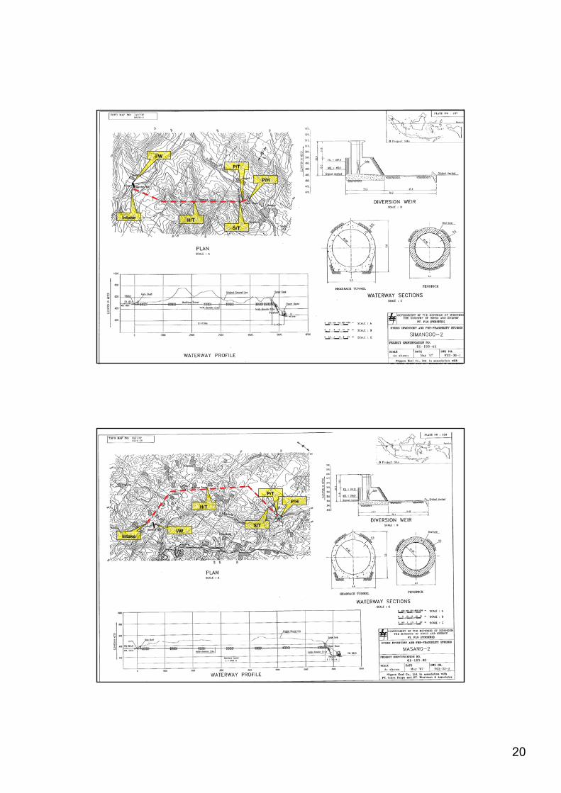
20
39
Intake
P/H
H/TS/T
P/T
I/W
40
Intake
P/HH/T
S/T
P/T
I/W
21
41
3. Outline of Further Investigation
42
3-1. Outline of Survey at Pre F/S
1) Candidate Sites• Simanggo-2 (North Sumatra)• Masang-2 (West Sumatra)2) Site Survey• Geological Survey• Topographical Survey• Hydrological Survey• Environmental Survey

22
43
3-2. Outline of Geological Survey
• Surface geological mapping• Core drilling investigation• Seismic refraction survey• In-situ tests• Laboratory tests for selected soil and rock
samples
1) Survey Items
44
3-2. Outline of Topographical Survey
• Control point survey (Benchmark survey) by GPS
• Leveling• Topographic mapping or digital mapping• Terrestrial map by spot survey• Longitudinal profile and cross-section survey
1) Survey Items
23
45
3-3. Outline of Hydrological Survey
1) Survey Items
• Installation of water level gauge• Water level observation and recording• Stream flow measurement• Suspended load sampling and testing• Riverbed material sampling and testing• Water quality test
46
3-4. Environmental and Social Considerations
1) Objectives of Environmental Survey2) Method of Provisional Scoping for 2 Pre-F/S
Projects3) Results of Provisional Scoping4) Items of environmental Survey5) Work Schedule6) Plan of 3rd Stakeholder Meeting
24
47
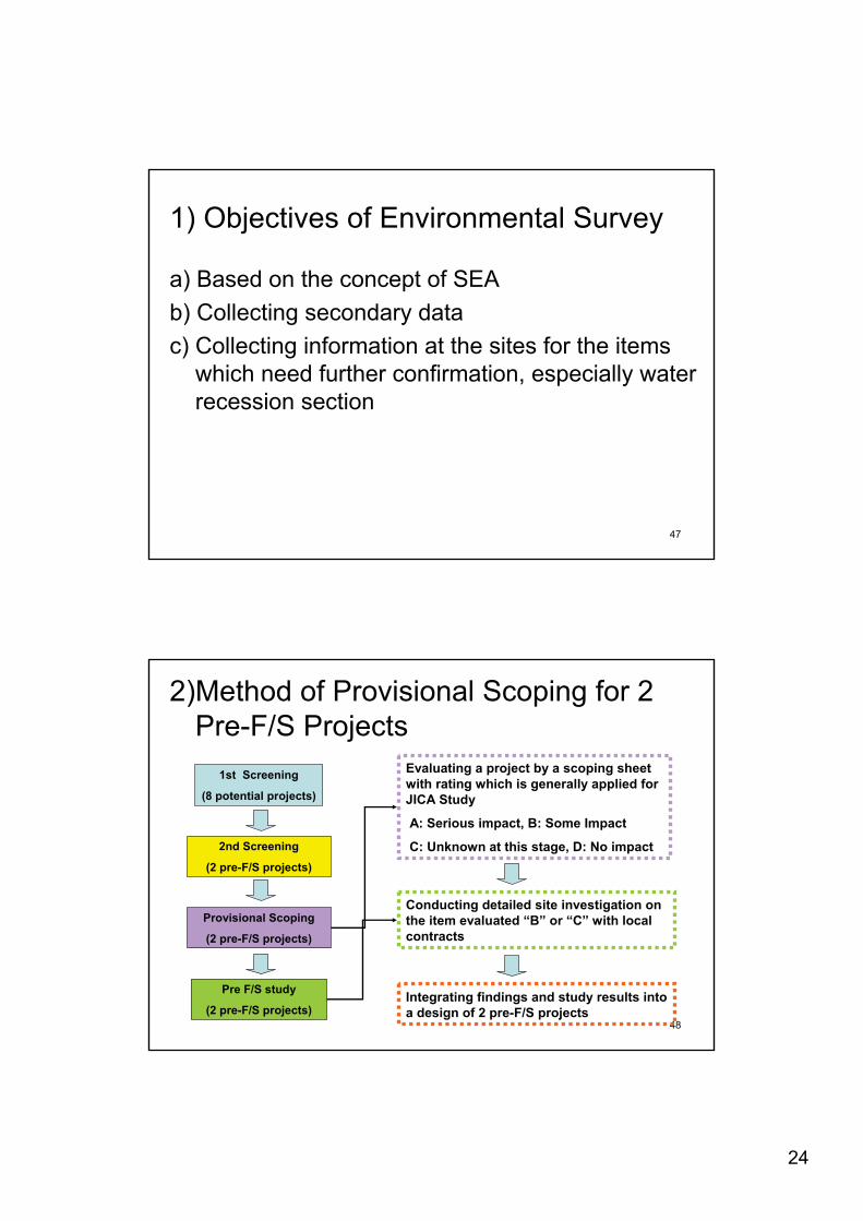
1) Objectives of Environmental Survey
a) Based on the concept of SEAb) Collecting secondary datac) Collecting information at the sites for the items
which need further confirmation, especially water recession section
48
2)Method of Provisional Scoping for 2 Pre-F/S Projects
2nd Screening
(2 pre-F/S projects)
Pre F/S study
(2 pre-F/S projects)
1st Screening
(8 potential projects)
Provisional Scoping
(2 pre-F/S projects)
Evaluating a project by a scoping sheet with rating which is generally applied for JICA Study
A: Serious impact, B: Some Impact
C: Unknown at this stage, D: No impact
Conducting detailed site investigation on the item evaluated “B” or “C” with local contracts
Integrating findings and study results into a design of 2 pre-F/S projects
25
49
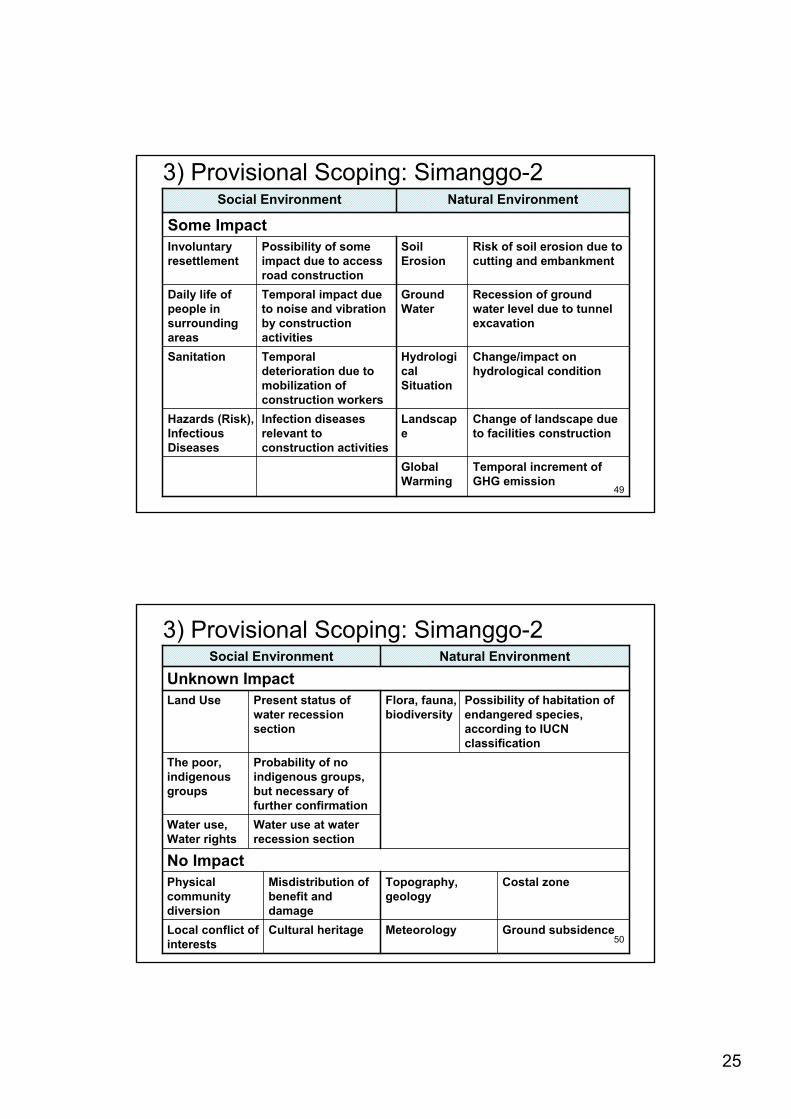
3) Provisional Scoping: Simanggo-2
Some Impact
Infection diseases relevant to construction activities
Temporal increment of GHG emission
Global Warming
Change of landscape due to facilities construction
Landscape
Hazards (Risk), Infectious Diseases
Change/impact on hydrological condition
HydrologicalSituation
Temporal deterioration due to mobilization of construction workers
Sanitation
Recession of ground water level due to tunnel excavation
Ground Water
Temporal impact due to noise and vibration by construction activities
Daily life of people in surrounding areas
Risk of soil erosion due to cutting and embankment
SoilErosion
Possibility of some impact due to access road construction
Involuntary resettlement
Natural EnvironmentSocial Environment
50
3) Provisional Scoping: Simanggo-2Natural EnvironmentSocial Environment
No ImpactCostal zoneTopography,
geologyMisdistribution of benefit and damage
Physical community diversion
Water use at water recession section
Water use, Water rights
Ground subsidenceMeteorologyCultural heritageLocal conflict of interests
Probability of no indigenous groups, but necessary of further confirmation
The poor, indigenous groups
Possibility of habitation of endangered species, according to IUCN classification
Flora, fauna, biodiversity
Present status of water recession section
Land UseUnknown Impact
26
51
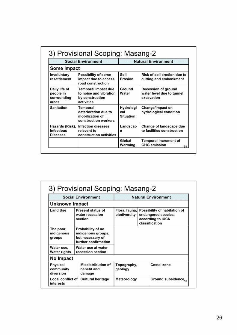
3) Provisional Scoping: Masang-2
Some Impact
Infection diseases relevant to construction activities
Temporal increment of GHG emission
Global Warming
Change of landscape due to facilities construction
Landscape
Hazards (Risk), Infectious Diseases
Change/impact on hydrological condition
HydrologicalSituation
Temporal deterioration due to mobilization of construction workers
Sanitation
Recession of ground water level due to tunnel excavation
Ground Water
Temporal impact due to noise and vibration by construction activities
Daily life of people in surrounding areas
Risk of soil erosion due to cutting and embankment
SoilErosion
Possibility of some impact due to access road construction
Involuntary resettlement
Natural EnvironmentSocial Environment
52
3) Provisional Scoping: Masang-2Natural EnvironmentSocial Environment
No ImpactCostal zoneTopography,
geologyMisdistribution of benefit and damage
Physical community diversion
Water use at water recession section
Water use, Water rights
Ground subsidenceMeteorologyCultural heritageLocal conflict of interests
Probability of no indigenous groups, but necessary of further confirmation
The poor, indigenous groups
Possibility of habitation of endangered species, according to IUCN classification
Flora, fauna, biodiversity
Present status of water recession section
Land UseUnknown Impact
27
53
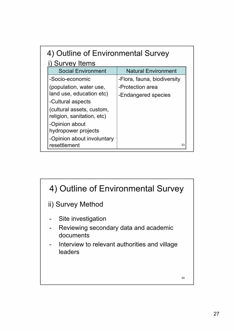
4) Outline of Environmental Surveyi) Survey Items
-Flora, fauna, biodiversity -Protection area-Endangered species
-Socio-economic(population, water use, land use, education etc)-Cultural aspects(cultural assets, custom, religion, sanitation, etc)-Opinion about hydropower projects-Opinion about involuntary resettlement
Natural EnvironmentSocial Environment
54
4) Outline of Environmental Survey
ii) Survey Method
- Site investigation - Reviewing secondary data and academic
documents- Interview to relevant authorities and village
leaders
28
55
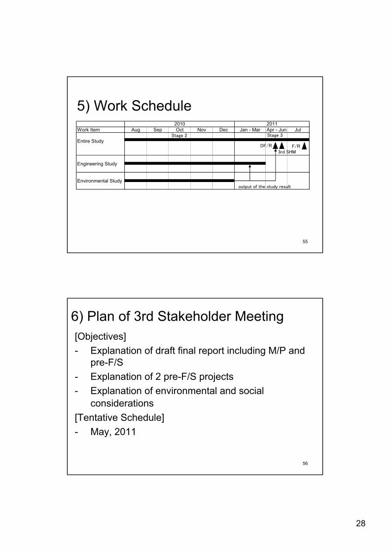
5) Work ScheduleWork Item Aug Sep Oct Nov Dec Jan - Mar Apr - Jun Jul
Entire Study
Engineering Study
Environmental Study
2010 2011
56
6) Plan of 3rd Stakeholder Meeting[Objectives]- Explanation of draft final report including M/P and
pre-F/S- Explanation of 2 pre-F/S projects- Explanation of environmental and social
considerations[Tentative Schedule]- May, 2011

29
57
Question & Answer
58
Thank you very much for your attention


![㠢㠸㠧㠳ã å ã 㠼㠿 2007ç · (9 ÷]9]W]d] ][]/] ] ]O]2\ / ÷ ñ ® ³ .]']d] ]+]0 ÿ º 3 ò 1\» 60$57 9 + Title: 㠢㠸㠧㠳ã å ã 㠼㠿_2007ç](https://img.pdfslide.us/doc/110x75/60325704c2c96c22f606dc61/-2007-9-9wd-o2-.jpg)


![cesamiæ ä½ ã ã ã ¥ã ¢ã «ï¼ å ©ç ¨è ï¼ .ppt [äº æ 㠢㠼ã ]](https://img.pdfslide.us/doc/110x75/61e096d23e6110489c3fa9c0/cesami-.jpg)