Embed Size (px)
Citation preview

E102002011SAC/172769/008-14.DOC 8.14-1
8.14 Water Resources8.14.1 IntroductionThis subsection evaluates the effect of the Walnut Energy Center (WEC) project on waterresources. Subsection 8.14.2 presents the LORS compliance strategy. Subsection 8.14.3describes the hydrologic setting, Subsection 8.14.4 characterizes water use and disposal, andSubsection 8.14.5 discusses precipitation, storm runoff, and drainage. Subsection 8.14.6discusses the project’s effects on water resources. Mitigation is discussed in Subsection8.14.7. Subsection 8.14.8 provides the proposed monitoring plans and complianceverification procedures. Subsection 8.14.9 discusses cumulative impacts. Subsection 8.14.10lists the permits required and agency contacts. Subsection 8.14.11 provides the referencesconsulted in preparing this subsection.
Water resources potentially affected by the proposed WEC project include the following:
• Effects on water supply• Effects on surface waters• Effects on groundwater recharge, degradation, or depletion• Effect of stormwater • Effects on flooding
These issues are addressed in detail below.
8.14.2 Applicable Laws, Ordinances, Regulations, and StandardsFederal, state, county, and local laws, ordinances, regulations, and standards (LORS)applicable to water resources and conformance are discussed in this subsection andsummarized in Table 8.14-1.
8.14.2.1 FederalThe Clean Water Act (CWA) authorizes the U.S. Environmental Protection Agency (USEPA)to regulate discharges of wastewater and stormwater into surface waters by issuingNational Pollutants Discharge Elimination System (NPDES) permits. The Central ValleyRegional Water Quality Control Board (RWQCB) implements these permits at the statelevel, but USEPA may retain jurisdiction at its discretion. The CWA’s primary effect onWEC is with respect to the control of soil erosion during construction and the need toprepare and implement site-specific erosion control plans and measures for the constructionof each project element that will require disturbance of surface soil.
Section 404 of the CWA regulates wetland fill and dredge in jurisdictional waters, andprovides guidance on crossing waterways. The U.S. Army Corps of Engineers (USACE)administers Section 404 permits for fill of waterways. If any of the waterways crossed bypipelines or the project are considered jurisdictional, the project will be required to acquire404 and 401 permits. Compliance with 404 permits are described in more detail inSubsection 8.2, Biological Resources.
Section 401 of the CWA requires a water quality Certification or Waiver to be issued incombination with a 404 permit.

SUBSECTION 8.14 WATER RESOURCES
E102002011SAC/172769/008-14.DOC 8.14-2
TABLE 8.14-1Laws, Ordinances, Regulations, and Standards Applicable to WEC Water Resources
LORS Applicability How Conformance Is Achieved Agency/Contact
Federal
Clean Water Act (CWA) asimplemented by the RegionalWater Quality Control Board(RWQCB)
Regulates stormwater discharge by issuingConstruction Activity NPDES Stormwater Permit
NPDES permits for constructionstormwater prior to construction and plantoperation.
RWQCB
George DayRWQCB3443 Routier RoadSacramento, CA255-3506
Clean Water Act Section 401 Water Quality Certification Requires water quality certification forany Section 404 permit; delegated toRWQCB.
RWQCB
George DayRWQCB3443 Routier RoadSacramento, CA255-3506
Clean Water Act Section 404 Wetlands disturbance Section 404 permit for work injurisdictional wetlands, if any. Requiredprior to any work below the high-watermark of the creek.
USACE
Kathy NortonEnvironmental Engineer1325 J StreetSacramento, CA 95814-2922916-557-5260
State
NPDES permit for stormwater,construction, or temporarydewatering
Regulates stormwater discharge (see above) NPDES permits for construction andindustrial stormwater prior to constructionand plant operation.
George DayRWQCB3443 Routier RoadSacramento, CA255-3506

SUBSECTION 8.14 WATER RESOURCES
E102002011SAC/172769/008-14.DOC 8.14-3
TABLE 8.14-1Laws, Ordinances, Regulations, and Standards Applicable to WEC Water Resources
LORS Applicability How Conformance Is Achieved Agency/Contact
Title 22 of the CCR Requirements for the use of sewage effluent incooling towers
City of Turlock WWTP effluent will meetTitle 22 requirements.
Greg VaughnRWQCB3433 Routier RoadSacramento, CA255-3142
Joe SpanoDHSStockton, CA(209)948-7696
Dan MaddenWastewater ManagerDepartment of Public UtilitiesTurlock Wastewater PlantTurlock, CA 93706
California Water Code 13550et seq. and Resolution 75-58
Encourages reuse of water for beneficial use Not applicable since project is notapplying to the State Water ResourcesControl Board (SWRCB) for a newappropriation of water. However, projectis proposed to use recycled water.
Paul LilleboState Water Resources Control BoardEnvironmental Specialist IV901 P StreetSacramento, CA 95812916-341-5551
CDFG (Fish and Game Code,Section 1601)
Streambed Alteration Agreement May be required to construct gas pipelineunder Lateral No. 5.
CDFGDr. Andrew GordusEnvironmental Specialist IV1234 East Shaw AvenueFresno, CA 93710559-243-4014

SUBSECTION 8.14 WATER RESOURCES
E102002011SAC/172769/008-14.DOC 8.14-4
TABLE 8.14-1Laws, Ordinances, Regulations, and Standards Applicable to WEC Water Resources
LORS Applicability How Conformance Is Achieved Agency/Contact
Local
City of Turlock Approval by City of Grading Plan includesstormwater control requirements
Requires erosion and sediment controlplan, drainage control features, and Cityapproval.
City of TurlockBrad KoehnEngineering TechnicianTurlock, California 93660209-668-5590
Turlock Grading Ordinance Permits Grading, Erosion, and Sediment Control Required prior to site grading. Applicationalso comprises CEQA, GeotechnicalReport, and Erosion and SedimentControl Plan.
City of TurlockBrad KoehnEngineering TechnicianTurlock, California 93660209-668-5590
Turlock Water and Sewer Permit Required for septic, leachfield, or other disposalsystems.
Planning Review Bela BidalStanislaus County EnvironmentalResources DepartmentModesto, CA(209)525-6700
Jim SteinmanCity of TurlockTurlock, California 93660(209) 668-5542 ext 2217
SUBSECTION 8.14 WATER RESOURCES
E102002011SAC/172769/008-14.DOC 8.14-5
8.14.2.2 StateState LORS applicable to this project are compliance with California Environmental QualityAct (CEQA), the Porter Cologne Act, and California Department of Fish and Game (CDFG)administration of the streambed alteration program.
8.14.2.2.1 California Environmental Quality ActCEQA requires that projects approved by state agencies be evaluated for their potential tocause adverse environmental impacts, and that impacts be mitigated to the extent feasible.The California Energy Commission (CEC) Preliminary and Final Staff Assessments are theCEQA-equivalent process.
8.14.2.2.2 State Water Resources Control Board and Central Valley Regional Water QualityControl BoardThe RWQCB requires a notice of intent to be filed prior to construction activities.Stormwater Pollution Prevention Plans (SWPPPs) must be prepared prior to filing both theConstruction and General Industrial Stormwater NPDES permits. The State WaterResources Control Board (SWRCB) Water Quality Order No. 99-08-DWQ applies toconstruction activity NPDES stormwater permits for construction areas of greater than5 acres. SWRCB Order 97-03-DWQ authorizes general industrial stormwater permits.
8.14.2.2.3 California Water Code Sections 13550, 13551, 461, and SWRCB Resolution No. 75-58These water code sections and policy statements encourage the conservation of waterresources and the maximum reuse of wastewater, particularly in areas where water is inshort supply.
8.14.2.2.4 Title 22 of the California Code of RegulationsTitle 22 addresses the use of recycled water; in particular Section 60306 sets forth the criteriafor the use of recycled water for cooling. Such cooling water is defined as disinfectedtertiary recycled water in Section 60401.230.
8.14.2.2.5 Fish and Game Code Section 1601 Streambed Alteration AgreementCDFG administers the Streambed Alteration Agreement (SAA) for actions that will disturbbeds and banks of surface streams. An SAA may be required for gas pipeline construction atirrigation canals. CDFG has not yet determined if the gas pipeline crossing under Lateral 5will require an SAA.
8.14.2.2.6 Water Quality CertificationIf a Section 404 permit for fill is required by USACE, it must be accompanied by aSection 401 permit issued by RWQCB. A permit may be required for gas pipelineconstruction at irrigation canals.
8.14.2.3 Local PoliciesLocal ordinances focus on flood control concerns, stormwater protection, and erosioncontrol as well as use of recycled water for cooling. The City of Turlock General Plan andStanislaus County General Plan specify policies that are summarized in Table 8.14-2. Theconformance of the project with these policies is also provided.

SUBSECTION 8.14 WATER RESOURCES
E102002011SAC/172769/008-14.DOC 8.14-6
TABLE 8.14-2Stanislaus County and City of Turlock General Plans, Goals, and Policies for Water Supply and Delivery Applicable to the Project
Element Goal/Policy Conformance
Stanislaus County General Plan
CONSERVATION/OPEN SPACE 2. Conserve water resources and protect water quality in the County. Project will conform by using recycled water.
POLICY FIVE Protect groundwater aquifers and recharge areas,particularly those critical for the replenishment of reservoirs and aquifers.
Project will conform by using recycled water within theCounty.
1. Proposals for urbanization in groundwater recharge areas shall bereviewed to ensure that (1 ) as much water as possible is returned to therecharge area, (2) the development will not cause discharge of materialsdetrimental to the quality of the water, and (3) the development will notresult in significant groundwater overdrafting or deterioration in quality.The Department of Environmental Resources shall require: A. In thoseareas where groundwaters are susceptible to overdrafting, the projectproponent shall perform a hydrogeological analysis and includeappropriate mitigation measures in the proposal. B. In those areas wheregroundwater quality is susceptible to deterioration or is already ofreduced quality, the level of wastewater treatment shall be such that itwill not cause further quality deterioration.
Project will conform by using recycled water within theCounty.
2. The Department of Environmental Resources shall identify and requirecontrol of point sources for pollutants stored, handled or disposed of onthe surface of the soil or in the vadose zone that is located in the zone oraeration immediately above the groundwater level. Potential sources ofpollutants to the groundwater may also include high densities ofindividual onsite sewage treatment units and/or the use of communitypackage treatment plants. The Department of Environmental Resourcesshall require the adoption of groundwater monitoring programs forprojects where hydrogeological assessments indicate the potential forgroundwater deterioration is likely. Responsible Department:Environmental Resources.
Project will conform by implementing BMPs to avoidpollutants entering stormwater drainage.

SUBSECTION 8.14 WATER RESOURCES
E102002011SAC/172769/008-14.DOC 8.14-7
TABLE 8.14-2Stanislaus County and City of Turlock General Plans, Goals, and Policies for Water Supply and Delivery Applicable to the Project
Element Goal/Policy Conformance
3. Eliminate reliance on dry wells as a means of street drainage in urbanareas. Dry wells collect and discharge toxic, hazardous, and designatedcontaminants into aquifers having beneficial uses. New projects shallhave stormwater disposal systems that: (1 ) are designed not to pollutereceiving surface or groundwaters, and (2) which could be integrated intoan areawide groundwater recharge program whenever feasible.Responsible Departments: Environmental Resources, Public Works,Planning Commission, Board of Supervisors.
Project will conform by implementing BMPs to avoidpollutants entering stormwater drainage.
4. During the project and environmental review process, encourage newdevelopment to incorporate water conservation measures to minimizeadverse impacts on water supplies. Possible measures include, but arenot limited to, low-flow plumbing fixtures, use of recycled wastewater forlandscaping when feasible, and use of drought-tolerant landscaping.
Project will conform by using recycled water.
5. Continue to implement the landscape provisions of the ZoningOrdinance, which encourage drought-tolerant landscaping and water-conserving irrigation methods. Responsible Departments: PlannIngDepartment, Planning Commission, Board of Supervisors.
Project will conform by using drought tolerant species forlandscaping to the extent feasible.
6. New development that does not derive potable water from pre-existingpotable and public water supply systems shall be required to have adocumented water supply that does not adversely impact StanislausCounty water resources.
IMPLEMENTATION MEASURES
1. Proposals for development to be served by new water supply systemsshall be referred to appropriate water districts, irrigation districts,community services districts, the State Water Resources Board, and anyother appropriate agencies for review and comment.
Project will conform by deriving recycled water from thepublic water supply system.
2. Review all development requests to ensure that sufficient evidencehas been provided to document the existence of a water supply sufficientto meet the needs of the project without adversely impacting the qualityand quantity of existing local water resources.
The City of Turlock has provided TID with a will serveletter for supplying water to the project.

SUBSECTION 8.14 WATER RESOURCES
E102002011SAC/172769/008-14.DOC 8.14-8
TABLE 8.14-2Stanislaus County and City of Turlock General Plans, Goals, and Policies for Water Supply and Delivery Applicable to the Project
Element Goal/Policy Conformance
City of Turlock General Plan
6.2-a Continue efforts to safeguard the quality and availability ofTurlock’s water supply.
Project has been evaluated for impacts on existing watersources and distribution facilities.
6.2-b Undertake steps to minimize the depletion of groundwaterreserves.
Project will use recycled water to reduce impacts togroundwater.
6.2-c Continue to participate in studies investigating future potable watersupply alternatives; evaluate future source alternatives.
Project supports using alternatives to groundwater byusing recycled water.
Water Quality and Conservation
6.2-d Continue water conservation efforts. Project will support water conservation by recyclingwater to the extent practicable.
Turlock Municipal Code
6-5-115 c) No person shall install or connect with the water system anyevaporative type air-conditioning cooler or unit unless it is equipped witha recirculating pump and equipped with a thermostat or pressure controlvalve properly adjusted to regulate the flow of cooling water through theunits so that the minimum amount of cooling water as determined by themanufacturer’s specifications shall be used.
Evaporative type air-conditioning coolers or units will notbe used.
d) No person shall connect to the water system any refrigerating or air-conditioning equipment unless such equipment is air-cooled or has awater tower or evaporation condenser so that only makeup water isused.
The project will use air-cooled condensers forrefrigerators and building air conditioning units.
e) No person shall waste water. The project will make efficient use of water and recycleto the extent practicable.
Source: Stanislaus County General Plan (2000), City of Turlock General Plan (2002), Turlock Municipal Code, (2002).

SUBSECTION 8.14 WATER RESOURCES
E102002011SAC/172769/008-14.DOC 8.14-9
8.14.3 Hydrologic SettingThe climate in the project area is typical of the Central San Joaquin Valley with hot drysummers and mild winters. Daytime temperatures during the summer months rangebetween 80°F and 100°F, with peak days up to 110°F. The rainy season generally extendsfrom November through March. Occasional rains occur during the spring and fall months,but summer months are dry. Average annual precipitation is approximately 12 inches.Elevation on the site is approximately 85 feet MSL.
The project site is located near the center of the valley, approximately midway between theSierra Nevada to the east, and the Coast Range to the west. The San Joaquin River is thenearest major surface water passing approximately 8 miles west of the project site. TheTurlock Main Canal is a man-made channel that conveys water south of Turlock and passesless than 0.5 mile south of the project site. The banks of the canal are elevated, such thatlocal drainage only enters the canal from pumps.
Potable water supplies for the City of Turlock are entirely groundwater from local wells.Potable groundwater is generally deep and alkaline, although there is a very shallowgroundwater table due to local irrigation. Groundwater is used to meet local potabledemands and surface water is used to meet local irrigation demands.
8.14.3.1 Surface WaterThe Tuolumne River is 11 miles to the north, the Merced River is 10 miles to the south, andthe San Joaquin River is 8 miles west of the project site. Groundwater and surface water arepumped into numerous surface canals and drains that deliver irrigation water to and fromagricultural fields throughout the region. These canals are packed earth or concrete-linedand generally lack the meanders, vegetation, biota, and other features of natural streams.There are no significant lakes or reservoirs within 10 miles, although small farm ponds arerelatively common. They all carry water of excellent quality at their sources in the SierraNevada Mountains, but as they flow through the valley, their quality is impaired by eachsuccessive use. Both agricultural and potable use and return contribute to this degradation.As flows decrease seasonally, concentrations of total dissolved solids, silt, algae, andpollutants increase to the extent that in the valley the rivers are turbid, warm, slow-moving,or seasonal with high amounts of algae and silt.
There are no significant natural water features on or adjacent to the project area. There isone man-made canal, (Turlock Main Canal) that delivers irrigation water from Turlockreservoir, which originates in the Tuolumne River, east of Turlock. Small distribution canalscrisscross farm fields and parallel roads, and cross the proposed project linears (gas andwater lines) in two places. The major rivers listed above are far enough away to beunaffected by the project, and therefore are not described in detail (Figure 8.14-1).
8.14.3.2 GroundwaterGroundwater is the major source of potable and industrial water in Stanislaus County, andis provided by the City of Turlock. Many industries and rural farms have onsite wells forsupply.

SUBSECTION 8.14 WATER RESOURCES
E102002011SAC/172769/008-14.DOC 8.14-10
Groundwater resources under the project site and the City of Turlock were evaluated in theGroundwater Management Plan for the Turlock Basin (1997), Water System Master Plan(1993), and Master Environmental Assessment for the City General Plan (City of Turlock2002a).
Depth to groundwater in the City of Turlock ranges from 35 feet in the eastern part to 15 feetin the west, and depth to the west was projected to increase as much as 90 feet by the year2020 (Brown and Caldwell 1988). Between 1976 and 1988, overall water level in the TurlockIrrigation District (TID) area dropped about 10 feet. In the City of Turlock, static water levelsdropped during the last drought, but after several wet years in the 1990s, water levels haveclimbed back to predrought levels (City of Turlock 2002b). The depth to groundwater east ofthe San Joaquin River, where the project is located, does not have the serious problems thatexist on the west side.
Groundwater levels fluctuate with seasonal rainfall, withdrawal, and recharge. The largedemand for groundwater has caused subsidence in some areas of the valley. However, thereare no records of such subsidence in the Turlock area (City of Turlock 2002b). Figure 8.14-2shows the groundwater in the project area. Additional geological detail is provided inSubsection 8.15 (Figure 8.15-2).
In the Turlock area, recharge to the unconfined/ semi-confined aquifer is primarily byirrigation water. Rainfall, at about 12 inches per year, is much less than evapotranspiration,resulting in an average water deficit of about 30 inches (City of Turlock 2002b). Thedifference is made up by imports to the watershed of about 27 inches (600,000 acre-feet) anda net withdrawal of about 3 inches (72,500 acre-feet) from aquifer storage. Urban use isabout 5 percent of the draw or 30,000 acre-feet per year (afy).
The overall quality of groundwater supplying the City is good, although some chemicals arepresent in varying amounts that might eventually cause some problems. These are chloride,nitrate, arsenic, sodium, calcium, magnesium, carbonate, DBCP, bicarbonate, and sulfate.Groundwater pumping around Modesto, improperly sealed wells, and past dairy practiceshave contributed to increasing concentrations of certain chemicals.
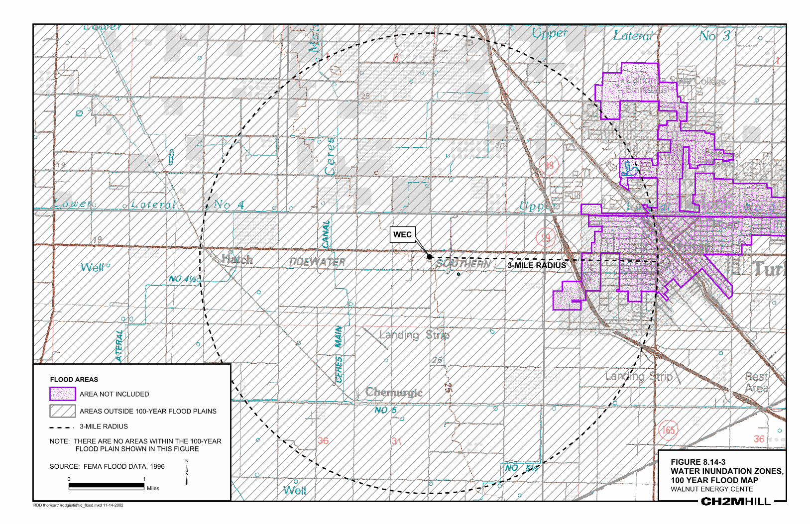
8.14.3.3 Flooding PotentialFederal Emergency Management Agency (FEMA) flood zone maps show that the WECproject site and all surrounding areas for a distance of approximately 2 miles are outside the100-year flood boundary (Figure 8.14-3). For all practical purposes, the community will notbe inundated by a 100-year flood.
The area south of the Tuolumne River is near the New Don Pedro Dam. According to theUSACE standards, the City and the project site are within the dam failure inundation area.Dam failure models show that the entire area would be flooded if the New Don Pedro Damwere to fail completely within a 1-hour period (City of Turlock 2002b). Such an occurrence isconsidered highly unlikely.

SUBSECTION 8.14 WATER RESOURCES
E102002011SAC/172769/008-14.DOC 8.14-11
8.14.4 Water Sources and DisposalThis subsection characterizes the sources of water needed for power generation at WEC,water quality, and disposal of wastewater. Average and maximum daily and annual waterdemand are provided in Table 8.14-3.
TABLE 8.14-3Average Daily, Maximum Daily, and Maximum Annual Water Usage and Wastewater Discharge for WEC
Water UseAverage Daily
Use (gpd)Maximum Daily
Use (gpd)Maximum Annual
Use (afy)
Process and Cooling Water 1,400,000 2,000,000 1,800
Potable Water Service 2,000 2,000 3
Sanitary Wastewater Discharge (toonsite septic and leachfield)
2,000 2,000 3
8.14.4.1 Cooling Water The proposed cooling water supply for the project is recycled water from the TurlockWastewater Treatment Plant (WWTP). The City of Turlock is in the process of permittingand building a Title 22 facility at its WWTP to meet new NPDES permit requirements. TheTurlock City Council has approved the funding mechanism for the plant and intends tohave the treatment plant on line by May 1, 2006.
Once the Title 22 plant becomes operational, the City has agreed to provide 1,800 afy ofrecycled water. Given that the Title 22 plant is not expected to be online until May 2006 andthat TID intends to commence start-up by the fourth quarter 2005, there will likely be aninterim period between the initial operation of the WEC facility and the availability ofrecycled water. The City has confirmed that it can deliver a “bridge” supply of water fromits existing facilities to meet the water needs of the WEC until the Title 22 plant isoperational. The City of Turlock has provided TID with a will serve letter for the use ofrecycled and potable water (Appendix 8.14a). The potential impacts of these uses aredescribed in Subsection 8.14.6 below.
Blowdown from the cooling tower will be treated onsite via a zero-liquid discharge (ZLD)system. Distillate from the ZLD system will be used to provide process makeup water.Details of the plant water cycle and process makeup water treatment are discussed inSection 2.0, Project Description.
8.14.4.2 Bridge Water SupplyTo bridge the time between the WEC online service and the expected operational date of theTitle 22 plant, TID proposes to use potable water from the City of Turlock. This water wouldbe diverted from the potable water main located at South Tegner Road approximately0.9 mile east of the WEC site. The project will already require the construction of a potablewater pipeline for potable, plant service, and fire protection water needs. An additionalpipeline will not be required for the bridge supply.

SUBSECTION 8.14 WATER RESOURCES
E102002011SAC/172769/008-14.DOC 8.14-12
As an example, until recycled water is available, the plant would be estimated to use one-half of the annual maximum, or 900 acre-feet (approximately 1.4 millions gallons per day[mgd]) of water. This represents approximately 2 percent of the 45 mgd currently availablefrom City wells.
The projections of population growth, development, land use, and agricultural conversionthrough the year 2020 were evaluated by the City of Turlock to determine whether watersupplies were adequate to serve future customers. Between the years of 1982 and 1991, theCity population grew at a rate of 5 percent. Since then, population growth has slowedslightly and was estimated to increase 3.7 percent by year 2020. This will put the populationat approximately 126,000 in 2020 (Turlock 2002).
Considering projected land use, the average day water consumption for 1995 was9,700 gallons per minute (gpm), which will increase to approximately 19,400 gpm by theyear 2020 (City of Turlock 1993). These estimates and demand coefficients correspond to theland use development predicted by the City Planning department, and includeimplementation of the Water Conservation and Education ordinance passed in 1991.
The regional demand for City water depends on climate, land use, cost of water, availabilityof alternative sources of water, lawn sprinkling, and cultural attitudes. Because Turlock isgenerally warm and dry, annual use is higher than national averages. This is primarilybecause of additional lawn sprinkling and cooling requirements (City of Turlock 1993).Water demand normally fluctuates throughout the year, and normally peaks in June or July.Similarly, water availability and recharge fluctuates with peak availability during wintermonths (December and January).
8.14.4.3 Recycled Water SupplyThe City of Turlock owns and operates a regional WWTP that serves all of Turlock and thecommunity service districts of Keyes and Denair as well as several industrial facilities.Currently the WWTP provides secondary treatment and chlorination. The effluent isdischarged to Harding Drain, which in turn discharges to the San Joaquin River,approximately 8 miles east of the facility.
In response to recent changes in the effluent discharge criteria, the City is constructing aWater Recycling Project to upgrade wastewater treatment standards from secondary to tertiarytreatment. Treatment facilities will include high-rate flocculation, filtration, and new chlorinationand dechlorination facilities. The resulting effluent will be high-quality water that can meetTitle 22 California Water Recycling Criteria (CWRC) for unrestricted reuse by May 2006. Thedesign flow for the tertiary facilities will be 20 mgd, with peak flows of 30 mgd. The Cityis committed to completing this project, and a schedule for operations is included inAppendix 8.14B. The items in section A are required prior to delivering recycled water. Itemsunder “B” and pipeline and post aeration are not required to deliver recycled water.
8.14.4.4 Recycled Water Quality As noted above, recycled water quality will meet all Title 22 requirements. Table 8.14-4summarizes estimated recycled water quality from the City of Turlock’s recycled water systembased on water quality data from the City of Turlock, and the City’s Title 22 pilot testingprogram. For each constituent or parameter, the highest concentration observed was used,except where the constituent is reduced by Title 22 treatment (e.g., turbidity and suspended

SUBSECTION 8.14 WATER RESOURCES
E102002011SAC/172769/008-14.DOC 8.14-13
solids). The project will be designed to accommodate variations from this quality, as the finalquality will not be known until the project becomes active in early 2006. The quality of thepotable “bridge” water is expected to be similar, but better, than the recycled water.
TABLE 8.14-4Estimated Recycled Water Quality
Constituent Recycled Water(mg/l except as noted)
Alkalinity-Bicarbonate 206
Alkalinity-Total 206
Aluminum 0.100
Ammonia <57
Arsenic 0.010
Barium 0.080
Biological Oxygen Demand <10
Boron 0.200
Cadmium 0.002
Chemical Oxygen Demand <30
Chloride 104
Chromium 0.004
Copper 0.020
Fluoride 0.380
Hardness-Calcium 82
Hardness-Magnesium 9.9
Hardness-Total 143
Iron 0.440
Lead 0.012
Manganese 0.047
Molybdenum 0.010
Nickel 0.010
Nitrate Nitrogen <20
pH, pH units 6.5-7.5
Potassium 20
Selenium 0.010
Silica 57
Silver 0.003
Sodium 145

SUBSECTION 8.14 WATER RESOURCES
E102002011SAC/172769/008-14.DOC 8.14-14
TABLE 8.14-4Estimated Recycled Water Quality
Constituent Recycled Water(mg/l except as noted)
Specific Conductance, umhos/cm 1,011
Sulfate 45
Total Dissolved Solids 537
Total Suspended Solids <1
Turbidity, NTU 2, or less
Zinc 0.080
8.14.4.5 Alternative Cooling Water Sources The SWRCB Policy 75-58 specifies that to protect water quality and quantity, water rightsapplications for cooling water for power plants can only be approved if other sources ofwater are not feasible. Since the project is not applying for new water rights, Policy 75-58 isnot applicable; however the following is a discussion of the alternative sources of coolingwater listed in Policy 75-58 for consideration (in order of preference).
1. Wastewater being discharged to the ocean2. Ocean3. Brackish water from natural sources or irrigation return flow4. Inland wastewater of low total dissolved solids (TDS)5. Other inland waters
The proposed WEC will be over 100 miles from the ocean, and therefore, the first two watersources are not feasible alternatives. Similarly, there are no sources of naturally brackishwater in the vicinity. The dominant agricultural uses in the project area are irrigated but thereturn flow supply would be of variable quality and the quantity during the year. Althoughuse of irrigation return flow might be technically feasible, it is not as reliable a supply asrecycled water from the WWTP and would be more costly to treat in the ZLD system. Thenearest practical source of irrigation return water would be the Harding Drain, locatedapproximately 3 miles south of the project site. The additional cost of constructing a pipelineto the Harding drain makes this a less attractive alternative than using recycled water. Inaddition, the use of irrigation return water would require a significantly larger ZLD systemto process cooling tower blowdown, consuming greater amounts of chemicals and energy,and producing greater amounts of salt cake.
In the case of WEC, one of the dominant reasons why the site was selected was theavailability of a large quantity of recycled water from the WWTP and the shortinterconnection to the electric transmission facilities. The project would also benefitStanislaus County by reducing the amount of wastewater that the City of Turlock mustdischarge to the San Joaquin River.

SUBSECTION 8.14 WATER RESOURCES
E102002011SAC/172769/008-14.DOC 8.14-15
The use of recycled water from the WWTP is appropriate, will benefit the City of Turlock,and is consistent with the order of preference stated in Policy 75-58.
With respect to using water from the Turlock potable supply until the recycled water isavailable, the bridge supply is a reasonable use, since it requires only the infrastructure thatwill be necessary for the permanent potable system to be installed.
8.14.4.6 Potable WaterThe project proposes to use potable water from the City of Turlock for all potable plantservice water, and fire protection needs.
8.14.4.3.1 Potable Water SupplyThe City supplies potable water to approximately 12,000 residential, industrial andcommercial connections from 23 deep groundwater wells, with a combined capacity of45 mgd. Water consumption in Turlock has grown 14 percent over the last 4 years and thesystem is currently operating at near-capacity levels during summer months (City ofTurlock 2002b). The City has plans to install three additional wells, which will add 2 mgd ofcapacity.
The WEC project will require 0.4 gpm for potable water use and another 1.0 gpm for plantservice water, which represents less than 0.01 percent of City water use. This usage isconsidered insignificant when compared to water demands of the City, and is not likely tocause any adverse effects. A will serve letter is provided in Appendix 8.14A.
8.14.4.3.2 Potable Water QualityPotable water quality from the City meets all EPA Maximum Contaminant Levels (MCL) fordrinking water.
8.14.4.7 Wastewater Discharges As discussed in Section 2.0, process wastewater at the site will be recycled in a ZLDtreatment system (see Subsection 8.13). No industrial wastewater will be discharged offsite.Because there will be no liquid discharges, no table of water quality or quantity is providedfor discharges. As a final step in the ZLD process, concentrated brine will pass through acrystallizer and press producing a relatively dry salt cake. This salt cake will be collected foroffsite disposal at an appropriate landfill.
Sanitary wastewater estimated at 0.4 gpm will be discharged to an onsite septic system andleachfield meeting the requirements of the City and County regulations.
8.14.4.8 Water Flow and TreatmentThe mass balances of water flow and treatment include varying water requirements fordifferent operational conditions. Section 2.0 discusses the facilities for treatment and use ofproject water. Water balances are presented on Figures 2.2-6a and 2.2-6b. Section 7.0discusses the water pipelines for conveyance.
SUBSECTION 8.14 WATER RESOURCES
E102002011SAC/172769/008-14.DOC 8.14-16
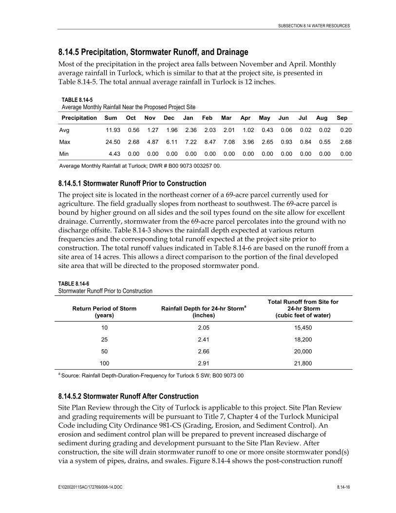
8.14.5 Precipitation, Stormwater Runoff, and DrainageMost of the precipitation in the project area falls between November and April. Monthlyaverage rainfall in Turlock, which is similar to that at the project site, is presented inTable 8.14-5. The total annual average rainfall in Turlock is 12 inches.
TABLE 8.14-5Average Monthly Rainfall Near the Proposed Project SitePrecipitation Sum Oct Nov Dec Jan Feb Mar Apr May Jun Jul Aug Sep
Avg 11.93 0.56 1.27 1.96 2.36 2.03 2.01 1.02 0.43 0.06 0.02 0.02 0.20
Max 24.50 2.68 4.87 6.11 7.22 8.47 7.08 3.96 2.65 0.93 0.84 0.55 2.68
Min 4.43 0.00 0.00 0.00 0.00 0.00 0.00 0.00 0.00 0.00 0.00 0.00 0.00
Average Monthly Rainfall at Turlock; DWR # B00 9073 003257 00.
8.14.5.1 Stormwater Runoff Prior to ConstructionThe project site is located in the northeast corner of a 69-acre parcel currently used foragriculture. The field gradually slopes from northeast to southwest. The 69-acre parcel isbound by higher ground on all sides and the soil types found on the site allow for excellentdrainage. Currently, stormwater from the 69-acre parcel percolates into the ground with nodischarge offsite. Table 8.14-3 shows the rainfall depth expected at various returnfrequencies and the corresponding total runoff expected at the project site prior toconstruction. The total runoff values indicated in Table 8.14-6 are based on the runoff from asite area of 14 acres. This allows a direct comparison to the portion of the final developedsite area that will be directed to the proposed stormwater pond.
TABLE 8.14-6Stormwater Runoff Prior to Construction
Return Period of Storm(years)
Rainfall Depth for 24-hr Storma
(inches)
Total Runoff from Site for 24-hr Storm
(cubic feet of water)
10 2.05 15,450
25 2.41 18,200
50 2.66 20,000
100 2.91 21,800a Source: Rainfall Depth-Duration-Frequency for Turlock 5 SW; B00 9073 00
8.14.5.2 Stormwater Runoff After ConstructionSite Plan Review through the City of Turlock is applicable to this project. Site Plan Reviewand grading requirements will be pursuant to Title 7, Chapter 4 of the Turlock MunicipalCode including City Ordinance 981-CS (Grading, Erosion, and Sediment Control). Anerosion and sediment control plan will be prepared to prevent increased discharge ofsediment during grading and development pursuant to the Site Plan Review. Afterconstruction, the site will drain stormwater runoff to one or more onsite stormwater pond(s)via a system of pipes, drains, and swales. Figure 8.14-4 shows the post-construction runoff

SUBSECTION 8.14 WATER RESOURCES
E102002011SAC/172769/008-14.DOC 8.14-17
and drainage patterns for the developed site. If more than one stormwater pond is used, thedrainage patterns will be modified slightly to direct stormwater to the ponds. There will beno offsite discharge of stormwater. The stormwater pond(s) will be designed as percolationponds in accordance with City of Turlock’s Specifications and Design Standards. Theremaining portion of the 69-acre parcel will be restored to pre-construction conditions.
Table 8.14-7 shows the calculated quantity of runoff for various storm return periods.Section 17 SD-7C of the City of Turlock’s Specifications and Design Standards requires thatthe stormwater pond(s) be sized to contain 3-inches of rainfall over the impervious area ofthe new development, which is in excess of the 100-year event assuming no deduction forpre-development runoff (Koehn, B. City of Turlock, Personal Communication). The runoffassociated with 3 inches of rainfall is estimated to be 74,957 cubic feet, or 1.72 acre-feet. Thestormwater pond(s) will be designed to contain approximately 2 acre-feet.
TABLE 8.14-7Stormwater Runoff Following Construction
Return Period of Storm(years)
Rainfall Depth for 24-hr Storm(inches)
Total Runoff from Site for24-hr Storm
(cubic feet of water)
10 2.05 51,501
25 2.41 60,590
50 2.66 66,649
100 2.91 72,708a Source: Rainfall Depth-Duration-Frequency for Turlock 5 SW; B00 9073 00
8.14.6 Project Effects on Water ResourcesSignificance criteria are derived from the CEQA Appendix G checklist. The project isconsidered to have a potentially significant effect if it would:
• Substantially alter the existing drainage pattern of the site or area, including through thealteration of the course of a stream or river, in a manner which will result in substantialerosion or siltation on- or offsite, or in flooding on- or offsite.
• Create or contribute runoff water which will exceed the capacity of existing or plannedstormwater drainage systems, or provide substantial additional sources of pollutedrunoff.
• Violate any water quality standards or waste discharge requirements, or otherwisesubstantially degrade water quality.
• Substantially deplete groundwater supplies or interfere substantially with groundwaterrecharge such that there will be a net deficit in aquifer volume or a lowering of the localgroundwater table level (e.g., the production rate of pre-existing nearby wells will dropto a level which will not support existing land uses or planned uses for which permitshave been granted).

SUBSECTION 8.14 WATER RESOURCES
E102002011SAC/172769/008-14.DOC 8.14-18
• Place housing within a 100-year flood hazard area as mapped on a federal Flood HazardBoundary or Flood Insurance Rate Map or other flood hazard delineation map.
• Place within a 100-year flood hazard area structures that will impede or redirect floodflows.
• Expose people or structures to a significant risk of loss, injury, or death involvingflooding, including flooding as a result of the failure of a levee or dam.
• Cause inundation by seiche, tsunami, or mudflow.
8.14.6.1 Effects on Surface WaterThere are no significant natural surface waters in the project vicinity. The project site is flat,and will remain generally flat after development. The project will not substantially alterexisting drainage patterns. Therefore, the project will cause no substantial erosion orsiltation on- or offsite. Similarly, the volume and rate of runoff from the project site will notbe substantially altered as a result of project development, nor will the project alter thecourse of any stream or river. The project will capture and detain stormwater runoff in anonsite stormwater basin, so the project will not exceed the capacity of existing or plannedstormwater drainage systems.
8.14.6.2 Effects on GroundwaterDuring operation, the City of Turlock will supply potable water for sanitary needs, plantservice water, and fire protection to the project. The main source of this water isgroundwater from local wells. The amounts of water required for potable supply andservice water is estimated at approximately 2 afy, as compared to the much greaterrequirements for cooling tower makeup (1,800 afy of recycled water). Although the regionhas generally experienced some water table drop related to groundwater pumping, theprimary uses are agricultural, not potable. The potable supply to the project represents lessthan 0.01 percent of the annual groundwater provided by the City to other users, and willnot substantially deplete groundwater supplies or interfere with groundwater recharge. Nowells will be expected to drop to a level that will not support existing land uses.
Because WEC is scheduled to require water for testing and operation prior to completion ofthe recycled water plant, WEC proposes to temporarily use City of Turlock potable waterfor cooling. The total water use during this period would be less than 1.4 mgd, whichrepresents 5 percent of the 45 mgd currently available.
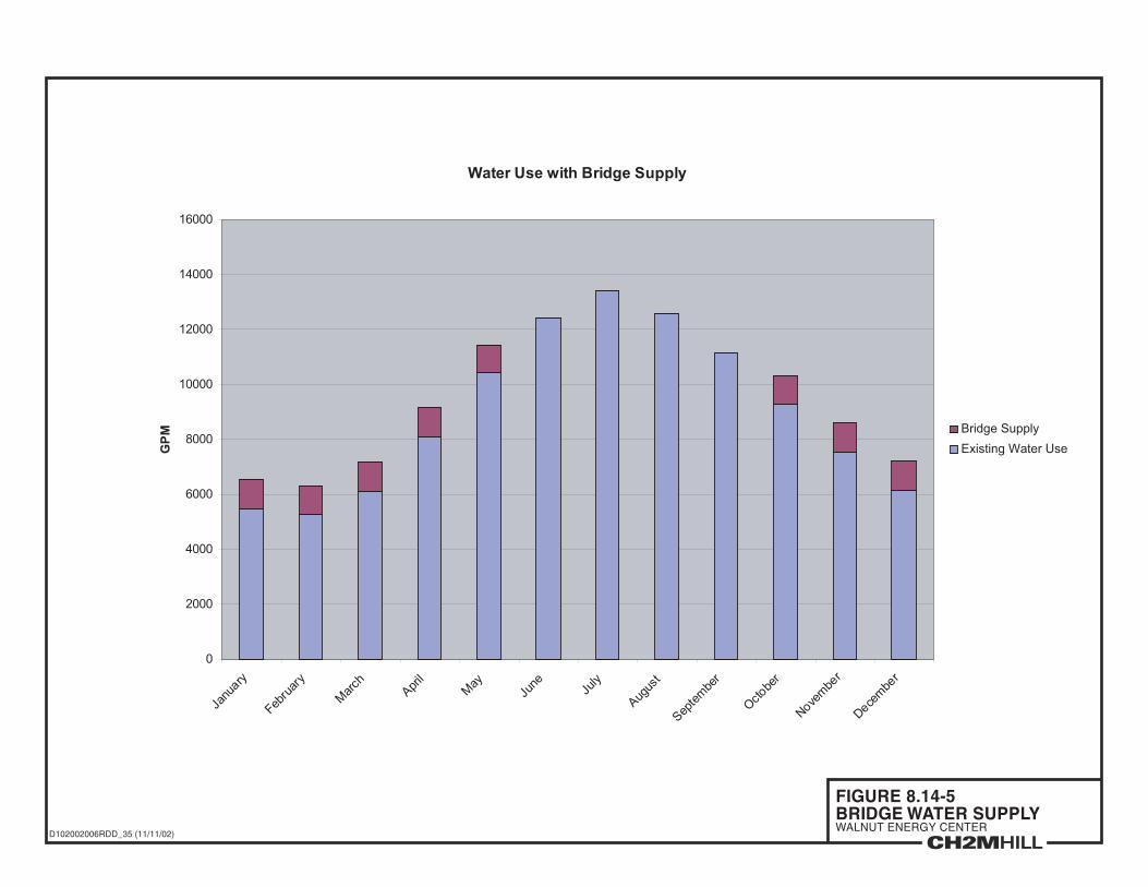
Figure 8.14.5 shows the annual fluctuations in water demand based on data from 1989-19911. Water use in winter is much less than summer, and the City, as a matter of practiceshuts down more than half its available wells during winter months (D. Madden, personalcomment). In Figure 8.14-5, the stacked bar shows the additional demands that 1.5 mgdwould place on the regional system for the bridge supply. It is evident that water use wouldincrease demands slightly during winter months, when regional demands are lower, andhave no effect on summer demands during the bridge supply.
1 Data from 1989-91 were used because these were readily available. Actual water use in 2002 is greater but follows the samepattern as shown.
SUBSECTION 8.14 WATER RESOURCES
E102002011SAC/172769/008-14.DOC 8.14-19
Once recycled water is available, the WEC project will require 2,000 gpd for potable andplant service water, which represents less than 0.01 percent of City water use. Thisincrement is considered insignificant when compared to water demands of the City, and isnot likely to cause any adverse effects.
Best Management Practices (BMPs) will be implemented during construction to avoidcontamination of groundwater from construction activities. As a result of these measures,groundwater in the project area will not be significantly affected by the project.
8.14.6.3 Effects on Recycled WaterThe project will use recycled water from City of Turlock WWTP for cooling tower makeup.Recycled water use will have a net positive impact on water resources by reducing theamount of water discharged to the San Joaquin River and is consistent with the CECobjective for reusing water to the greatest extent practicable.
8.14.6.4 Effects on Stormwater The project site is flat and has no offsite drainage. Development of the site will not changethe general slope and aspect, and drainage will be conveyed to an onsite detention pond.Implementation of BMPs during construction and operation will be sufficient to controloffsite runoff and prevent offsite sedimentation. During construction and operation, BMPsdocumented in the SWPPP (part of the NPDES permit) for erosion and sediment control willbe implemented to avoid site runoff.
BMPs include designating locations for vehicle parking and maintenance, waste disposalareas, silt fencing, and installation of oil-water separators if necessary to prevent pollutantsfrom entering the stormwater system. The project will have no offsite discharges to surfacewater and, therefore, will not violate water quality standards or waste dischargerequirements nor substantially degrade water quality.
8.14.6.5 Effects on Water QualityLocal surface water and groundwater quality will not be affected by the project. In fact, asdiscussed in Subsection 8.14.6.3, the project’s use of recycled water will have a net positivebenefit on water resources by reducing the amount of water discharged into the San JoaquinRiver by the City. Process wastewater will be directed to the ZLD system for reuse. Sanitarywastes will be disposed to an onsite septic system, discharging to an onsite leachfield underpermit from the City.
Onsite stormwater pond(s) will be provided to contain stormwater, allowing it to percolateinto the ground. Thus, the project will not have a significant effect on the quantity andquality of stormwater runoff.
Stormwater runoff will be controlled during construction and plant operations throughadherence to SWRCB SWPPPs. These plans will be prepared as part of the application forboth the Construction and General Industrial Stormwater NPDES permits that will berequired as part of the project. A description of current erosion conditions is provided inSubsection 8.9, Agriculture and Soils. Hazardous materials storage and handling and wastehandling that must be thoroughly documented in the SWPPPs are presented inSubsections 8.12 and 8.13.

SUBSECTION 8.14 WATER RESOURCES
E102002011SAC/172769/008-14.DOC 8.14-20
8.14.6.6 Effects on Flooding PotentialThe State Reclamation Board has identified and adopted floodplains, defined in cubic feetper second of flow, along the San Joaquin River, Merced River, and Tuolumne River. Anynonagricultural encroachment into these areas requires a permit from the ReclamationBoard, which will serve to prevent reduction in channel capacity of the waterways.
The project is located approximately 2 miles from the nearest 100-year floodplain defined byFEMA (see Figure 8.14-3). Therefore, it will not place housing or structures in the 100-yearflood hazard area, nor place structures that will impede or redirect flood flows.
The project will convert up to 20 acres of the existing cultivated soil to packed gravel andpavement. An onsite stormwater pond will be used to contain stormwater, allowing it topercolate into the ground.
Project linears (gas, water, wastewater) will be buried below ground and therefore will notobstruct or impede flood waters at any time. The relative area that will be covered by linearsis small relative to available percolation areas, and therefore will have no significant effecton the regions ability to absorb floodwaters.
The general region is flat, and there are no significant dams or levees in the vicinity.Therefore, the project will not expose people or structures to significant risk of loss, injury ordeath resulting from a levee or dam failure. Similarly the project is located approximately105 miles from the Pacific Ocean, and any potential inundation from seiche, tsunami, ormudflow is remote.
8.14.7 Mitigation Measures to Reduce ImpactsImplementation of the WEC project with the following measures will effectively reduceimpacts to ground or surface water to less-than-significant.
• The project will use recycled water provided by City of Turlock WWTP for cooling-tower makeup.
• Process wastewater will be disposed to a ZLD system to avoid offsite migration ofwastewater products.
• No adverse impact to beneficial use of surface water will result from water supply to theproject, and no mitigation is required.
• The project will use approximately 2 afy of groundwater for onsite potable and servicewater uses. This amount is insignificant relative to the productive capacity of the localaquifers. Therefore, no mitigation is required.
• The project will implement Best Management Practices during construction andoperation to avoid contamination of any groundwater or surface waters.
8.14.8 Proposed Monitoring Plans and Compliance Verification ProceduresRoutine monitoring and compliance verification will be required as part of the stormwaterNPDES permitting of the project. The Applicant will be required to prepare an SWPPPspecifying BMPs, and monitoring and compliance measures to avoid adverse impacts to

SUBSECTION 8.14 WATER RESOURCES
E102002011SAC/172769/008-14.DOC 8.14-21
water quality. No additional monitoring of surface or groundwater will be required becauseno water quality impacts are expected to occur.
8.14.9 Cumulative ImpactsCumulative impacts to water resources could occur through the use of recycled water, thecontribution of potable sewage, the use of groundwater, or stormwater runoff.
None of these categories of water use is expected to result in significant cumulative impactsto area water resources:
• Surface Water: The project area is relatively flat and there are no natural surface waterfeatures in the vicinity. Implementation of BMPs during construction and operation willreduces the potential for adverse impacts to surface water from the project.
• Recycled Water: The use of recycled water will have a net positive benefit for watersupplies in the region.
• Plant Sewage: The proposed plant staff of approximately 21 employees will generateinsignificant volumes of treated, potable sewage that will be discharged to an onsiteseptic and leachfield as permitted by the City and County. The cumulative impacts fromthis additional waste load will not be significant.
• Groundwater: The project’s groundwater requirements of 2 afy are a very small portionof the overall water demands of the City of Turlock and will not be significant.Therefore, no adverse impacts to groundwater resources are predicted.
• Stormwater: Implementation of the project will increase runoff on up to 14 acres, due topacked earth and gravel, or pavement construction. The impacts of the increased runoffwill be mitigated through the use of an onsite stormwater pond designed to containstormwater, allowing it to percolate into the ground.
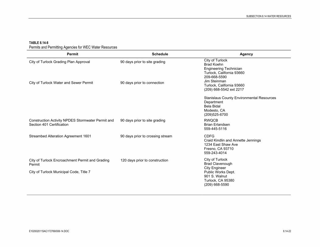
8.14.10 Permits Required and Agencies ConsultedWater quality permits required for the project include the following:
• City of Turlock Water and Sewer Permit
• RWQCB Construction Activity NPDES Stormwater Permit, General Permit
• RWQCB General Industrial NPDES Stormwater Permit, General Permit
• Streambed Alteration Agreement (Section 1601) for modifications to any creek, ifrequired for construction of the gas pipeline
• USACE Wetlands fill permit Section 404 for fill in jurisdictional wetlands, if required forconstruction of the gas pipeline
• Water Quality Certification Section 401, from the RWQCB, if 404 permit required
A summary of required permits and agency contacts is provided in Table 8.14-8.
SUBSECTION 8.14 WATER RESOURCES
E102002011SAC/172769/008-14.DOC 8.14-22
TABLE 8.14-8Permits and Permitting Agencies for WEC Water Resources
Permit Schedule Agency
City of Turlock Grading Plan Approval 90 days prior to site grading City of TurlockBrad KoehnEngineering TechnicianTurlock, California 93660209-668-5590
City of Turlock Water and Sewer Permit 90 days prior to connection Jim SteinmanTurlock, California 93660(209) 668-5542 ext 2217
Stanislaus County Environmental ResourcesDepartmentBela BidalModesto, CA (209)525-6700
Construction Activity NPDES Stormwater Permit andSection 401 Certification
90 days prior to site grading RWQCBBrian Erlandsen559-445-5116
Streambed Alteration Agreement 1601 90 days prior to crossing stream CDFGCraid Kindlin and Annette Jennings1234 East Shaw AveFresno, CA 93710559-243-4014
City of Turlock Encroachment Permit and GradingPermit
City of Turlock Municipal Code, Title 7
120 days prior to construction City of TurlockBrad ClavenoughCity EngineerPublic Works Dept.901 S. WalnutTurlock, CA 95380(209) 668-5590

SUBSECTION 8.14 WATER RESOURCES
E102002011SAC/172769/008-14.DOC 8.14-23
8.14.11 ReferencesBrown and Caldwell. 1988. Phase I Final Report: Drinking Water Supply Study.
City of Turlock. 1993. Water System Master Plan. Prepared by Boyle EngineeringCorporation, September.
City of Turlock. 2002a. Turlock General Plan: 1992-2012. Drafted September 1992.Reviewed 2002.
City of Turlock. 2002b. Turlock General Plan Master Environmental Assessment/DraftEnvironmental Impact Report. Reviewed 2002.
Federal Emergency Management Agency (FEMA). 2000. Flood Insurance Rate Map,Stanislaus County.
Madden, D. 2002. City of Turlock Water Quality Engineer. Personal Communication to EJKoford, CH2M Hill October 31, 2002.
Martin, Cliff. 2002. Memorandum to Steve Kyte, March 15, 2002. Wastewater FacilityDischarge Permit/ Sewer Use Fees.
Stanislaus County. 1994. Stanislaus County General Plan.
Stanislaus County Planning Commission. 1990. Stanislaus County General Plan SupportDocumentation, Adopted 1987, Revised 1990.
Turlock Irrigation District. 1997. Turlock Groundwater Basin Groundwater ManagementPlan. October 14.

SITE LOCATION
0 2Miles
³WALNUT ENERGY CENTER
FIGURE 8.14-1LOCAL SURFACE WATER FEATURES
RDD thor\cart1\rddgis\tid\tid_waterways.mxd 10-08-2002

����������������
����������������������������������� ����������� ��
� ������ ����
�������������� �
3-MILE RADIUS
0 1
Miles³
WALNUT ENERGY CENTE
FIGURE 8.14-3WATER INUNDATION ZONES, 100 YEAR FLOOD MAP
WEC
RDD thor\cart1\rddgis\tid\tid_flood.mxd 11-14-2002
SOURCE: FEMA FLOOD DATA, 1996
FLOOD AREAS
AREA NOT INCLUDED
AREAS OUTSIDE 100-YEAR FLOOD PLAINS
3-MILE RADIUS
NOTE: THERE ARE NO AREAS WITHIN THE 100-YEAR FLOOD PLAIN SHOWN IN THIS FIGURE

FIGURE 8.14-4
WEC PROPOSED DRAINAGE
FACILITIES
WALNUT ENERGY CENTER
TID W102002011SAC FIG8_14_4.ai 11-15-2002sbm
D102002006RDD_35 (11/11/02)
FIGURE 8.14-5BRIDGE WATER SUPPLYWALNUT ENERGY CENTER
Water Use with Bridge Supply
0
2000
4000
6000
8000
10000
12000
14000
16000
Janu
ary
Febru
ary
Mar
ch
Apr
il
May
June
July
Aug
ust
Sep
tem
ber
Oct
ober
Nove
mbe
r
Dece
mbe
r
GP
M
Existing Water Use
Bridge Supply