Embed Size (px)
Citation preview
8 Province systems characterisations
Figure 1 Defined provinces of the Bay of Bengal Large Marine Ecosystem.
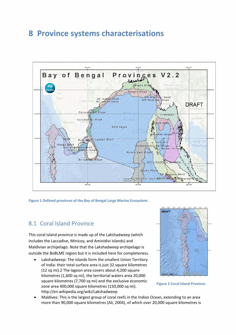
8.1 Coral Island Province
This coral island province is made up of the Lakshadweep (which
includes the Laccadive, Minicoy, and Aminidivi Islands) and
Maldivian archipelago. Note that the Lakshadweep archipelago is
outside the BoBLME region but it is included here for completeness.
Lakshadweep: The islands form the smallest Union Territory of India: their total surface area is just 32 square kilometres (12 sq mi).2 The lagoon area covers about 4,200 square kilometres (1,600 sq mi), the territorial waters area 20,000 square kilometres (7,700 sq mi) and the exclusive economic zone area 400,000 square kilometres (150,000 sq mi). http://en.wikipedia.org/wiki/Lakshadweep
Maldives: This is the largest group of coral reefs in the Indian Ocean, extending to an area more than 90,000 square kilometres (Ali, 2004), of which over 20,000 square kilometres is
Figure 2 Coral Island Province.

coral reef and lagoon habitats (comprised of 16 atolls, five oceanic faros and four oceanic platform reefs) (Naseer & Hatcher, 2004). The islands form a ring‐like structure around the edge of the Maldives Plateau, with a deep passage located north of Kaafu Atoll (which is roughly at latitude 4°30' N and 73°30' E). The total reef area is 4,513 square kilometres (Naseer & Hatcher, 2004) and has over 1,100 species of reef fishes and over 250 species of corals (Ministry of Housing and Environment, 2010).
8.1.1 PROVINCE BOUNDARIES
Unique ocean ridge system down to 2000m depth
Arabian Sea to the West and Laccadive Sea to the East
Connects to the south west Indian continental slope and shelf in the north
Deep nutrient‐rich water upwells as monsoonal currents flow over ridge
Important topographic feature for productivity going into both Arabian Sea and Bay of Bengal
Allows deep water species to interact with deep ocean and with south west Indian continental margin
8.1.2 BIOPHYSICAL DRIVERS
Geomorphological Features
Atolls ‐ 26 atolls in a north‐south chain ‐ atolls lie in a double chain in the central part of the Maldives, partially enclosing an "inner
sea".
‐ features that increase from north to south are; lagoon depths, continuity of atoll rim reef, and the amount of rainfall (Ali, 2004).
‐ features that increase from south to north are; number of faros, number of patch reefs inside the atoll, effects of storms, seasonal reversal, number of reefs with a single island (Ali, 2004).
Lagoons ‐ up to 60m depth inside atoll, up to 200m depth in outer lagoons. ‐ inner lagoon often with numerous coral ridges rising to within 10m of the water surface.
Sea Mounts ‐ rising from ~800m depth to within ~100m depth of the sea surface

Figure 3 Map of Coral Island geomorphology.
Climate
SW Monsoon (May to October) brings rain and the seas are moderate to rough.
NE Monsoon (November to April) brings rain and the seas are moderate to rough.
Winds, humidity, rainfall, temperature and salinity are strongly affected by the monsoons.
Equatorially trapped Wyrtki jet (intense and narrow eastward surface current occurring twice a year during the monsoon transition periods in spring and fall).
The monsoonal changes in weather and oceanography are key drivers of the strong seasonal cycles in and around this province.
Oceanography
Surface currents are strongly affected by the monsoons.
The north–south chain of atolls lying perpendicular to the east–west flow of the monsoon currents.
Interactions of the currents, during the monsoons, with the islands is an important driver of the productivity of this province (see section on Productivity).
Water column structure shows layers of water masses changing between 1500 to 2000 m.

8.1.3 ECOLOGICAL ASSETS
Habitats
Mangroves: ‐ 12% of the land in the Maldives is covered with mangroves, 13 species (belonging to 9
genera) are found (Ministry of Housing and Environment, 2010); most mangrove are located in Northern and Southern most atolls
‐ 3 protected mangrove areas (http://asia‐parks.org/pdf/wg2/APC_WG2‐08_Fazeela%20Ahmed%20Shaheem.pdf); K. Huraa Mangrove area, Eydhigali Kilhi, Koattey Area of S.Hithadhoo, and Goidhoo Kulhi
‐ Depression mangroves are found in enclosed areas along the coast – fringing mangroves are non‐existent. (http://www.fao.org/docrep/x5627e/x5627e0a.htm)
• Coral Reefs: ‐ Maldives contributes to 5% of world’s coral reef system ‐ Reef systems ‐ Upper outer reef and inner reef (within the lagoon) ‐ Up to 20 m depth
• Seagrass: ‐ 5 species of seagrass found in Maldives ‐ Primarily found within the intertidal zone. ‐ E.g. on Mathifaruhuraa Island, the intertidal area (~2m depth) between the island ridge
and the outer reef ridge contains seagrass beds.
Figure 4 Map of size (km2) of seagrass, mangrove and coral cover within the Coral Island Province.
Sources ‐ Coral (IMAS‐USF (2005), IMaRS‐USF (2005), Spalding et al. (2001), UNEP‐WCMC (2010)); Seagrass (UNEP‐WCMC, Short FT (2005), Green EP, Short FT (2003)); Mangroves (UNEP‐WCMC, Giri C, Ochieng E, Tieszen LL, Zhu Z, Singh A, Loveland T, Masek J, Duke N (2011a). Giri C, Ochieng E, Tieszen LL, Zhu Z, Singh A, Loveland T, Masek J, Duke N (2011b)).
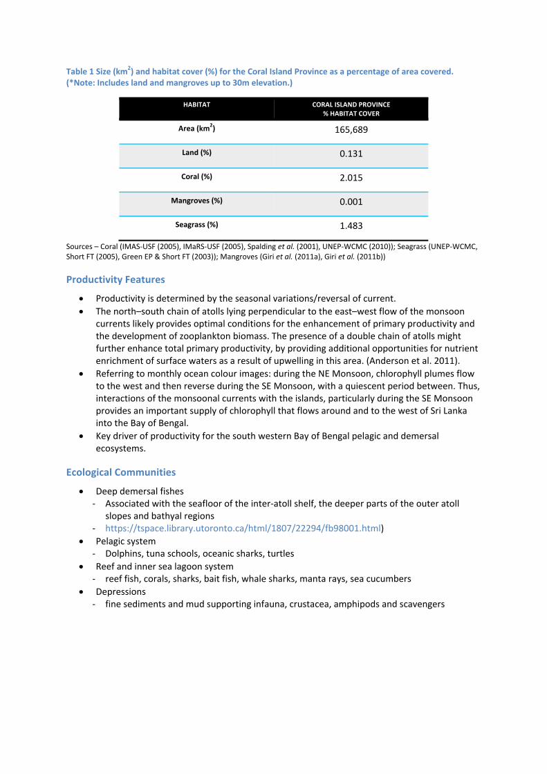
Table 1 Size (km2) and habitat cover (%) for the Coral Island Province as a percentage of area covered. (*Note: Includes land and mangroves up to 30m elevation.)
HABITAT CORAL ISLAND PROVINCE % HABITAT COVER
Area (km2) 165,689
Land (%) 0.131
Coral (%) 2.015
Mangroves (%) 0.001
Seagrass (%) 1.483
Sources – Coral (IMAS‐USF (2005), IMaRS‐USF (2005), Spalding et al. (2001), UNEP‐WCMC (2010)); Seagrass (UNEP‐WCMC, Short FT (2005), Green EP & Short FT (2003)); Mangroves (Giri et al. (2011a), Giri et al. (2011b))
Productivity Features
Productivity is determined by the seasonal variations/reversal of current.
The north–south chain of atolls lying perpendicular to the east–west flow of the monsoon currents likely provides optimal conditions for the enhancement of primary productivity and the development of zooplankton biomass. The presence of a double chain of atolls might further enhance total primary productivity, by providing additional opportunities for nutrient enrichment of surface waters as a result of upwelling in this area. (Anderson et al. 2011).
Referring to monthly ocean colour images: during the NE Monsoon, chlorophyll plumes flow to the west and then reverse during the SE Monsoon, with a quiescent period between. Thus, interactions of the monsoonal currents with the islands, particularly during the SE Monsoon provides an important supply of chlorophyll that flows around and to the west of Sri Lanka into the Bay of Bengal.
Key driver of productivity for the south western Bay of Bengal pelagic and demersal ecosystems.
Ecological Communities
Deep demersal fishes ‐ Associated with the seafloor of the inter‐atoll shelf, the deeper parts of the outer atoll
slopes and bathyal regions ‐ https://tspace.library.utoronto.ca/html/1807/22294/fb98001.html)
Pelagic system ‐ Dolphins, tuna schools, oceanic sharks, turtles
Reef and inner sea lagoon system ‐ reef fish, corals, sharks, bait fish, whale sharks, manta rays, sea cucumbers
Depressions ‐ fine sediments and mud supporting infauna, crustacea, amphipods and scavengers

Key species
FISHERIES
Tuna ‐ major fishery (in terms of export) ‐ 3 techniques; 1) pole and line fishery, 2) hand‐line fishery, and 3) long‐line fishery.
Yellowfin ‐ 2nd major fishery (in terms of export)
Bait fish ‐ 40 species ‐ most extensive coastal fishery ‐ important for the pole tuna fishery (http://www.fao.org/docrep/x5623e/x5623e0k.htm)
Grouper ‐ most significant reef fishery ‐ some species may be threatened (Ali, 2004)
Other fished/harvested species ‐ lobster ‐ sea cucumber (9 species) ‐ reef fish ‐ billfish ‐ red coral ‐ aquarium fish (~100 species, with 20 species comprising over 75% of the trade (Ali, 2004)). ‐ shark (3 fisheries – reef shark, deepwater gulper shark and oceanic shark).
THREATENED/PROTECTED
Turtles ‐ 5 species ‐ Green Turtle, Olive Ridley Turtle, Hawksbill Turtle, Loggerhead Turtle &
Leatherback Turtle
‐ A ten‐year moratorium on catching turtles is in force since 1995 (Ali, 2004). Whale shark
Sharks ‐ 38 species
Dolphins ‐ 7 species
Manta rays ‐ 2 species
Napoleon Wrasse

Figure 5 Schematic of the Coral Island Province (Maldives) showing selected features.
8.1.1 TRANS‐BOUNDARY LINKAGES
TBA

8.2 South East Arabian Seas (SEAS) Shelf Province
8.2.1 PROVINCE BOUNDARIES
Relatively wide shelf province of south west India
Terrestrial border comprises unique Western and Southern Ghats forests
Extensive fresh water and sediment flux from land
To the west is the unique Wadge Bank and Laccadive Sea
To the north, the Maldive Ridge intersects the Indian continental margin
8.2.2 BIOPHYSICAL DRIVERS
Figure 7 Map of South East Arabian Seas (SEAS) Shelf and Wadge Bank geomorphology.
Geomorphological Features
Shelf of terrigenous sand sandwiched between silty clay in the inner and outer shelf ‐ to ~200m depth ‐ ~40‐80km wide
Rivers
Figure 6 South East Arabian Seas (SEAS) Shelf and Wadge Bank Provinces.

‐ 41 rivers entering the system ‐ Large fresh water and sediment influx into system from back waters and estuaries
Oceanography
Strong upwelling during SW Monsoon (June‐September)
Seasonal reversal of WICC, poleward during winter (Nov to Feb) and Equatorward during summer (June‐Sept) monsoons
Rossby waves drive eddies
Mud banks with suspended silt and clay occurs during SW Monsoon up to 10 – 12 km from the shore
Mini‐warm pools form during April‐May
Freshening associated with Summer monsoon, creating a freshwater plume from ~40 rivers discharging into the ocean
Seasonal hypoxia associated with stratification of surface waters
Water masses: ‐ Arabian sea high salinity water mass ‐ 400 – 800 m Red sea water mass
Climate
Strong seasonality with Southwest and Northeast Monsoons
Rain fall approx. 300 cm/year
8.2.3 ECOLOGICAL ASSETS
Habitats
Mangroves ‐ 8 species ‐ Small patches along estuaries ‐ This conflicts with the USGS data displayed in Table 2 below.
Corals ‐ Small patches
Open shelf with sandy beaches
Laterite patches
Mud flats around river mouths

Figure 8 Map of size (km2) of seagrass, mangrove and coral cover within the SEAS and Wadge Bank Provinces.
Sources ‐ Coral (IMAS‐USF (2005), IMaRS‐USF (2005), Spalding et al. (2001), UNEP‐WCMC (2010)); Seagrass (UNEP‐WCMC, Short FT (2005), Green EP, Short FT (2003)); Mangroves (UNEP‐WCMC, Giri C, Ochieng E, Tieszen LL, Zhu Z, Singh A, Loveland T, Masek J, Duke N (2011a). Giri C, Ochieng E, Tieszen LL, Zhu Z, Singh A, Loveland T, Masek J, Duke N (2011b)).
Table 2 Size (km2) and habitat cover (%) for the SEAS Shelf Province as a percentage of area covered. (*Note: Includes land and mangroves up to 30m elevation.)
HABITAT SEAS SHELF PROVINCE% HABITAT COVER
Area (km2) 48,696
Land (%) 17.039*
Coral (%) 0.264
Mangroves (%) 0.000
Seagrass (%) 0.000
Sources – Coral (IMAS‐USF (2005), IMaRS‐USF (2005), Spalding et al. (2001), UNEP‐WCMC (2010)); Seagrass (UNEP‐WCMC, Short FT (2005), Green EP & Short FT (2003)); Mangroves (Giri et al. (2011a), Giri et al. (2011b))

Productivity Features
Seasonal phytoplankton bloom dominated by diatoms and occasionally dinoflagellates
Productivity maximum of 2 mg/m3
Trichodesmium blooms during oligotrophic spring time
Secondary production – Copepods dominated
Highly productive during SW monsoon (2‐3 mg/m3), although ocean colour images will be affected by turbidity from riverine outflows
Noticable increase in offshore productivity from April
Apex region where the Coral Island Province meets this Province is an area of complex topography and enhanced productivity
Ecological Communities
Small pelagics ‐ dominated by sardine, anchovies, mackerel
Demersals ‐ dominated by shrimps, perches, cuttlefish
Mid water ‐ dominated by ribbon fish, horse mackerel,
Benthos ‐ Polychetes (57%, 165 species, 32 families), ‐ Molluscs (gastropods), ‐ Crustaceans, ‐ Urochordates
Key species
THREATENED/PROTECTED
Turtles
Whales
Dolphins
Seabirds

Figure 9 Draft schematic of the SEAS Shelf (to 200m) and the Wadge Bank (from 200m onwards).
8.2.1 TRANS‐BOUNDARY LINKAGES
TBA

8.3 Wadge Bank Province
8.3.1 PROVINCE BOUNDARIES
Unique wide deep‐sea bank system off south west India
Productive region and one of the best fishing grounds
At the junction of Arabian Sea and Bay of Bengal deep water
Depositional platform for material from south west shelf province
Complex topography implies turbulent oceanic currents mixing deep waters
8.3.2 BIOPHYSICAL DRIVERS
Geomorphological Features
Canyons ‐ ~10 small canyons
Abyssal seamounts and plateaus ‐ 1 major plateau: Wadge Bank
Escarpments ‐ Several small escarpments ‐ major offshore escarpment at about latitude of Kollam (about 8'40" N)
Deep depressions
Province widens going north to south
Major change in topography and morphology at about the latitude of Kollam (about 8°40' N)
Oceanography
Seasonal gyral circulation
Seasonal reversal of WICC, poleward during winter (Nov to Feb) and Equatorward during summer (June‐Sept) monsoons
Rossby wave drive eddies
Water masses: ‐ 0‐200m : Arabian Sea High Salinity Water Mass (ASHSWM) ‐ 200‐400m: Persian Gulf Water Mass (PGW) ‐ 400 – 800m Red sea water mass (RSW)
Climate
Strong seasonality with Southwest and Northeast Monsoons
Rain fall approx. 300 cm/year
8.3.3 ECOLOGICAL ASSETS
Habitats
Canyons
Figure 10 South East Arabian Seas Shelf and Wadge Bank

Seamounts and plateaus
Escarpments
Deep depressions
Muddy habitats
Sand and gravel habitats
Rocky and volcanic substrates
Depositional fans at foot of slope and canyons
Table 3 Size (km2) and habitat cover (%) for the Wadge Bank Province as a percentage of area covered. (*Note: Includes land and mangroves up to 30m elevation.)
HABITAT WADGE BANK PROVINCE % HABITAT COVER
Area (km2) 54,676
Land (%) 0.000
Coral (%) 0.000
Mangroves (%) 0.000
Seagrass (%) 0.000
Sources – Coral (IMAS‐USF (2005), IMaRS‐USF (2005), Spalding et al. (2001), UNEP‐WCMC (2010)); Seagrass (UNEP‐WCMC, Short FT (2005), Green EP & Short FT (2003)); Mangroves (Giri et al. (2011a), Giri et al. (2011b))
Productivity Features
Oceanic oligotrophic, but the southern part of the slope becomes seasonally productive due to upwelling during the SW Monsoon
Turbidity from riverine outflows may reduce productivity and bind with organics before settling out from the water column
Productivity is enhanced in the northern part of the province due to the complex topography and interaction with currents and Rossby waves
Ecological Communities
Oceanic species ‐ dominated by tuna and sharks ‐ oceanic squids and myctophids also present
Demersal deep water species
Mid water
Benthos: Polychetes, Molluscs, Crustaceans, Urochordates
Key species
FISHERIES
Some additional information on fisheries from Fishing Chart for India by
Kåre Larssen. 1965. 12pp.

"... in nearly every trawl haul there are rays, sawfish or sharks. Such big fish can seriously damage a net and it should therefore be constructed with this in mind. The peak of the season for this ground is from July to October. The trawl catches then consist of sea bream. Rock cod, red snapper, blue spotted snapper, sharks, paraw (kingfish), cat fish yeela, orawa pathupara and other varieties. From October through June the catches consist of sea bream, rock cod, red snapper, blue spotted snapper and skates."
THREATENED/PROTECTED
Turtles
Whales
Dolphins
8.3.4 TRANS‐BOUNDARY LINKAGES
TBA

8.4 Gulf of Mannar Shelf Province
8.4.1 PROVINCE BOUNDARIES
Unique shelf environment in the Gulf of Mannar
Terrestrially, the western edge aligns with the eastern boundary of the Ghats mountain range
The eastern boundary is at the western edge of Palk Strait
Unique collection of conical offshore islands in eastern half
Province containing marine protected areas
8.4.2 BIOPHYSICAL DRIVERS
Figure 12 Map of Gulf of Mannar Shelf and Slope geomorphology.
Geomorphological Features
Atolls/Islands ‐ ~21 islands ‐ shingle islands parallel to the southeast coast of India
Steep slope on continental shelf ‐ ~20km to 200m depth ‐ Broad shelf off southern Indian coast narrowing towards north
Figure 11 Gulf of Mannar Shelf and SlopeProvinces.

Climate
Two wind regimes; the Southwest Monsoon (May to September) and Northeast Monsoon (December to February)
Two inter‐monsoonal periods March‐April and October‐November.
76‐127 cm/yr of rainfall during the NE Monsoon period – higher amounts occur during tropical cyclones that form during this time.
Oceanography
Seasonality dominated surface circulation
Winds reverse seasonally – fairly productive system
8.4.3 ECOLOGICAL ASSETS
Figure 13 Map of size (km2) of seagrass, mangrove and coral cover within the Gulf of Mannar Shelf and Slope, and the Palk Bay Provinces
Sources ‐ Coral (IMAS‐USF (2005), IMaRS‐USF (2005), Spalding et al. (2001), UNEP‐WCMC (2010)); Seagrass (UNEP‐WCMC, Short FT (2005), Green EP, Short FT (2003)); Mangroves (UNEP‐WCMC, Giri C, Ochieng E, Tieszen LL, Zhu Z, Singh A, Loveland T, Masek J, Duke N (2011a). Giri C, Ochieng E, Tieszen LL, Zhu Z, Singh A, Loveland T, Masek J, Duke N (2011b)).

Habitats
Coral reef
Seagrass
Seaweed
Pearl oyster beds
Mangroves ‐ Keelakarai, Vembar, Tuticorin island groups (Kathiresan et al, 2008) ‐ This conflicts with the USGS data (displayed in Table 4 below).
Table 4 Size (km2) and habitat cover (%) for Gulf of Mannar Shelf Province as a percentage of area covered. (*Note: Includes land and mangroves up to 30m elevation.)
HABITAT GULF OF MANNAR SHELF PROVINCE % HABITAT COVER
Area (km2) 19,181
Land (%) 27.434*
Coral (%) 0.152
Mangroves (%) 0.000
Seagrass (%) 10.274
Sources – Coral (IMAS‐USF (2005), IMaRS‐USF (2005), Spalding et al. (2001), UNEP‐WCMC (2010)); Seagrass (UNEP‐WCMC, Short FT (2005), Green EP & Short FT (2003)); Mangroves (Giri et al. (2011a), Giri et al. (2011b))
Productivity Features
High productivity (Chlorophyll peaks after Summer/SW Monsoon, max 2 mg/m3)
Eastward flow of productivity during the SW Monsoon
Enhanced productivity in the lee of offshore islands and seamounts
High biodiversity
Ecological communities
Biosphere Reserve around offshore islands ‐ High biodiversity – 3030 species ‐ Hard corals, sea turtles, sharks, oyster, gorgonian coral, sea snakes, sponges, seaweeds,
seagrass
Small pelagics ‐ Sardines, mackerel, anchovy, pomfret, mullet
Benthos ‐ Polychaetes, Molluscs, Crustaceans, Urochordates
Reef ‐ Pony fish, reef fish
Migratory, breeding species ‐ E.g. sea birds

Key species
FISHERIES
Total fished taxa is 657 species in 321 genera.
Coastal tunas
Sardines
Mackerel
Anchovies (breeding)
Skates/ rays
Pomfrets
Mullets
Shrimps (breeding)
Crabs
Cephalopods
Gastropods (many spp)
Sea cucumber
Chank
Oyster
THREATENED/PROTECTED
Turtles
Whales
Dolphin
Dugong
Sea birds
Sea horses

Figure 14 Schematic of the Gulf of Mannar Shelf and Slope Provinces.
8.4.1 TRANS‐BOUNDARY LINKAGES
TBA

8.5 Gulf of Mannar Slope province
8.5.1 PROVINCE BOUNDARIES
Similar considerations as for the Shelf Province
Changes in slope width oppose those for the Shelf
Unique north eastern portion in deep water at the head of the Gulf
NE portion may be a site of enhance deep ocean waves focussed to the head of the Gulf
8.5.2 BIOPHYSICAL DRIVERS
Geomorphological Features
Province includes slope of Gulf of Mannar and part of shelf of Sri Lanka
Canyons ‐ 6
Lagoon ‐ Kalpitiya
Terraces
Continental slope is between 200m to 3000m
Climate
Rainfall dominant during the NE/Winter Monsoon, mean annual rainfall is 76‐120 cm
Oceanography
Large fluxes through Adams Bridge/Palk Strait as this is a restricted passage between the Gulf of Mannar and Palk Bay. Sea level differences between the Bay of Bengal and the Arabian Sea drive the exchange of water and specific properties such as heat, salt and nutrients between the two seas. While tides and other short periodic driving forces (i.e. winds) create sea level variations and may drive instantaneous flows in either directions in shallow areas, the long‐term (monthly – seasonal) variations are those of importance for the net flux of water (volume flux) around the island of Sri Lanka. This is true also for the shallow strait areas between India and Sri Lanka, the size of which are large enough to create its own tidal circulation. Still, because the straits are shallow, the tides will affect the fluxes of various properties including the net volume flux, because high tidal velocities will create strong friction thereby limiting mean velocities and mean fluxes through the strait (i.e. Björk et al., 2000). In the Adams Bridge area, the wind driven flow during the monsoon periods for velocities of 0.8m/s in either direction (Anon. 2005). During inter‐monsoon periods, with low wind speed (Oct and Feb‐April) the flow is tidally driven, with maximum velocities during spring of 0.5‐0.6m/s. At very strong wind speeds (12‐14 m/s) velocities may reach 1.2 m/s. In the Palk Strait area, the velocities may reach 0.3‐0.4 m/s independent of wind directions, since the velocities are tidally dominated. The residual flows are probably primarily driven by the large scale sea level differences between the seas.
Salinity profiles have shown that there is no vertical stratification due to its shallowness and wind mixing by the Northeast Monsoon. Salinity varies from 29.5 ‐31.0 PSU (Arulananthan unpublished). The tides in this region are semidiurnal. The average spring tidal range is about 0.64 m and the neap tidal range is about 0.16 m (Ramesh 2004).

8.5.3 ECOLOGICAL ASSETS
Habitats
Coral reef
Seagrass
Mangroves ‐ Mandapam island group (Kathiresan et al, 2008)
Table 5 Size (km2) and habitat cover (%) for the Gulf of Mannar Slope Province as a percentage of area covered. (*Note: Includes land and mangroves up to 30m elevation.)
HABITAT GULF OF MANNAR SLOPE PROVINCE % HABITAT COVER
Area (km2) 29,312
Land (%) 4.335
Coral (%) 0.203
Mangroves (%) 0.055
Seagrass (%) 1.909
Sources – Coral (IMAS‐USF (2005), IMaRS‐USF (2005), Spalding et al. (2001), UNEP‐WCMC (2010)); Seagrass (UNEP‐WCMC, Short FT (2005), Green EP & Short FT (2003)); Mangroves (Giri et al. (2011a), Giri et al. (2011b))
Productivity Features
• Chlorophyll appears to peak October‐November after Summer Monsoon to ~2 mg/m3
However, production (amount of chlorophyll present) in other months may be high but productivity (and hence chlorophyll concentration) may be diffused by the strong mixing associated with exchange across the seas. Thus apparent low chlorophyll concentration does not necessarily imply low production (tallied across the water masses of the province for a given time period)
Satellite images show apparent high chlorophyll concentration during June at the start of the SW Monsoon (when exchange rates may be lower and hence mixing may be less intense)
Strong tidal currents and mixing will generate frontal features as the mixing encounters deeper water depths (according to for example the well‐known H/u3 Simpson‐Hunter (1974) formulation) and these may be preferential sites for upwelling, sedimentation and species accumulation
Ecological Communities
• Large pelagics: ‐ Oceanic tuna ‐ Swordfish ‐ Sail fish ‐ Barracuda ‐ Sharks
• Benthic: ‐ Polycheates, gastropods, urochordates, foramenifera
Migratory, breeding species ‐ E.g. sea birds
Key species
FISHERIES
Coastal tunas
Sardines
Mackerel
Anchovies (breeding)
Skates/ rays
Pomfrets
Mullets
Shrimps (breeding)
Crabs
Cephalopods
Gastropods (many spp)
Sea cucumbers
THREATENED/PROTECTED
Dolphins
Predatory whales
Dugongs
Sea birds
Sea horses
8.5.4 TRANS‐BOUNDARY LINKAGES
TBA

8.6 Southern Sri Lanka Shelf Province
8.6.1 PROVINCE BOUNDARIES
Shelf province encompassing Sri Lanka
Western end boundary at the head of the Gulf of Mannar
Eastern end boundary crosses the eastern entrance to Palk Bay
Unique fairly narrow shelf containing some slumps
At the confluence of the southern Arabian Sea and Bay of Bengal surface waters
8.6.2 BIOPHYSICAL DRIVERS
Figure 16 Map of Southern Sri Lanka Shelf and Slope geomorphology.
Geomorphological Features
Sandy bottom (in general)
Estuaries and lagoons ‐ ~45 ‐ e.g. Puttalam Lagoon, Negombo Lagoon, Baticaloa Lagoon
Figure 15 Southern Sri Lanka Shelf and Slope Provinces

Bays ‐ E.g. Koddiyar Bay, Arugam Bay
Continental shelf ‐ Shallow ‐22 m depth (Gunatilaka, 2010) ‐ Narrowest on southern end (near Matara) where it is less than 10km wide and descends
rapidly to deep water. Elsewhere locations such as this, for example the Ningaloo region of Western Australia, are renowned for their high biodiversity
‐ The north eastern segment of this province is the widest (over 60 km width) east of the entrance to Palk Bay.
‐ Slumps of the shelf are noted particularly off the south east coast (Figure 17), which would allow deep water to come into more intimate contact with shelf waters. Upwellings may also be enhanced.
Figure 17 An example of slumping of the shelf off the south east coast of Sri Lanka. Image exported from Google Earth.
Climate
Two wind regimes; the Southwest Monsoon (May to September) and Northeast Monsoon (December to February)
Two inter‐monsoonal periods March‐April and October‐November.
Oceanography
Reversing current system in response to the changing wind field: the eastward flowing Southwest Monsoon Current (SMC) during the Southwest (SW) monsoon transporting 11.5 Sv and the westward flowing Northeast Monsoon Current (NMC) transporting 9.5 Sv during the Northeast (NE) monsoon, respectively.
A recirculation feature located to the east of Sri Lanka during the SW monsoon, the Sri Lanka Dome (see Figure 18), is shown to result from the interaction between the SMC and
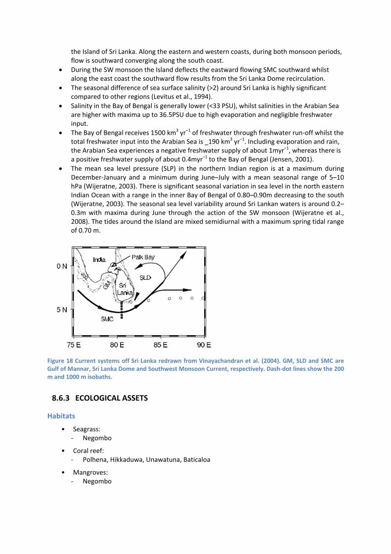
the Island of Sri Lanka. Along the eastern and western coasts, during both monsoon periods, flow is southward converging along the south coast.
During the SW monsoon the Island deflects the eastward flowing SMC southward whilst along the east coast the southward flow results from the Sri Lanka Dome recirculation.
The seasonal difference of sea surface salinity (>2) around Sri Lanka is highly significant compared to other regions (Levitus et al., 1994).
Salinity in the Bay of Bengal is generally lower (<33 PSU), whilst salinities in the Arabian Sea are higher with maxima up to 36.5PSU due to high evaporation and negligible freshwater input.
The Bay of Bengal receives 1500 km3 yr−1 of freshwater through freshwater run‐off whilst the total freshwater input into the Arabian Sea is _190 km3 yr−1. Including evaporation and rain, the Arabian Sea experiences a negative freshwater supply of about 1myr−1, whereas there is a positive freshwater supply of about 0.4myr−1 to the Bay of Bengal (Jensen, 2001).
The mean sea level pressure (SLP) in the northern Indian region is at a maximum during December‐January and a minimum during June–July with a mean seasonal range of 5–10 hPa (Wijeratne, 2003). There is significant seasonal variation in sea level in the north eastern Indian Ocean with a range in the inner Bay of Bengal of 0.80–0.90m decreasing to the south (Wijeratne, 2003). The seasonal sea level variability around Sri Lankan waters is around 0.2–0.3m with maxima during June through the action of the SW monsoon (Wijeratne et al., 2008). The tides around the Island are mixed semidiurnal with a maximum spring tidal range of 0.70 m.
Figure 18 Current systems off Sri Lanka redrawn from Vinayachandran et al. (2004). GM, SLD and SMC are Gulf of Mannar, Sri Lanka Dome and Southwest Monsoon Current, respectively. Dash‐dot lines show the 200 m and 1000 m isobaths.
8.6.3 ECOLOGICAL ASSETS
Habitats
• Seagrass: ‐ Negombo
• Coral reef: ‐ Polhena, Hikkaduwa, Unawatuna, Baticaloa
• Mangroves: ‐ Negombo

Figure 19 Map of size (km2) of seagrass, mangrove and coral cover within the Southern Sri Lanka Shelf and Slope provinces.
Sources ‐ Coral (IMAS‐USF (2005), IMaRS‐USF (2005), Spalding et al. (2001), UNEP‐WCMC (2010)); Seagrass (UNEP‐WCMC, Short FT (2005), Green EP, Short FT (2003)); Mangroves (UNEP‐WCMC, Giri C, Ochieng E, Tieszen LL, Zhu Z, Singh A, Loveland T, Masek J, Duke N (2011a). Giri C, Ochieng E, Tieszen LL, Zhu Z, Singh A, Loveland T, Masek J, Duke N (2011b)).
Table 6 Size (km2) and habitat cover (%) for the Sri Lankan Shelf Province as a percentage of area covered. (*Note: Includes land and mangroves up to 30m elevation.)
HABITAT SRI LANKAN SHELF PROVINCE % HABITAT COVER
Area (km2) 85,024
Land (%) 73.231*
Coral (%) 0.012
Mangroves (%) 0.095
Seagrass (%) 2.137
Sources – Coral (IMAS‐USF (2005), IMaRS‐USF (2005), Spalding et al. (2001), UNEP‐WCMC (2010)); Seagrass (UNEP‐WCMC, Short FT (2005), Green EP & Short FT (2003)); Mangroves (Giri et al. (2011a), Giri et al. (2011b))

Productivity Features
• The major upwelling region, during both monsoon periods, is located along the south coast and is shown to be due to flow convergence and divergence associated with offshore transport of water.
• Higher surface chlorophyll concentrations were observed during the SW monsoon. • The location of the flow convergence and hence the upwelling centre was dependent on
the relative strengths of wind driven flow along the east and west coasts: during the SW (NE) monsoon the flow along the western (eastern) coast was stronger and hence the upwelling centre was shifted to the east (west). The presence of upwelling along the south coast during both monsoon periods and the close proximity of deep water may explain the blue whale (Balaenoptera musculus) aggregations in this region (Vos et al., 2013) ‐ in much the same way that Whale Shark (Rhincodon typus) aggregate off the Ningaloo Coast of Western Australia.
Ecological Communities
• Small pelagics ‐ to 50m depth ‐ sardine, anchovy, herring, etc
• Medium pelagics ‐ in shelf areas and are also concentrated in areas beyond 50m depth ‐ Indian mackerel, Spanish mackerel, small tunas (kawakawa and frigate tuna), etc
• Large pelagics ‐ in shelf areas beyond 100m depth ‐ tuna
• Demeral ‐ shrimps, lobsters, crabs, gastropods – most productive range is 29‐60m depth ‐ Grouper, Snapper, Emperor – beyond 80 m depth
Key species
FISHERIES
Lobster ‐ South and east
Sharks ‐ Negombo, Beruwala, Mirissa
THREATENED/PROTECTED
Turtles ‐ West and south
Whales ‐ Mirissa, Trincomalee
Dolphins ‐ Trincomalee, Mirissa

Figure 20 Draft schematic of the (western) Sri Lanka Shelf Province. Need to show how monsoonal winds and currents cause surfacing of surface water layer and upwelling along the coast.
8.6.1 TRANS‐BOUNDARY LINKAGES
TBA

8.7 Southern Sri Lanka Slope Province
8.7.1 PROVINCE BOUNDARIES
Slope province encompassing Sri Lanka
Western end boundary at the head of the Gulf of Mannar
Eastern end boundary crosses the eastern entrance to Palk Bay
At the confluence of the southern Arabian Sea and Bay of Bengal deep waters
8.7.2 BIOPHYSICAL DRIVERS
Geomorphological Features
Sandy bottom (in general)
Canyons ‐ Trincomalee, Panadura, Dondra
Escarpments
Depositional environments
Slump fields
Continental slope ‐ concave feature that extends from 100–4000 m in depth ‐ on the southern and eastern coasts has an inclination of 45o which is one of the steepest
recorded globally
Climate
Two wind regimes; the Southwest Monsoon (May to September) and Northeast Monsoon (December to February)
Two inter‐monsoonal periods March‐April and October‐November.
Oceanography
Reversing current system in response to the changing wind field: the eastward flowing Southwest
Monsoon Current (SMC) during the Southwest (SW) monsoon transporting 11.5 Sv and the westward flowing Northeast Monsoon Current (NMC) transporting 9.5 Sv during the Northeast (NE) monsoon, respectively. (Vos et al, 2013)
A recirculation feature located to the east of Sri Lanka during the SW monsoon, the Sri Lanka Dome, is shown to result from the interaction between the SMC and the Island of Sri Lanka. Along the eastern and western coasts, during both monsoon periods, flow is southward converging along the south coast.
During the SW monsoon the Island deflects the eastward flowing SMC southward whilst along the east coast the southward flow results from the Sri Lanka Dome recirculation.
The seasonal difference of sea surface salinity (>2) around Sri Lanka is highly significant compared to other regions (Levitus et al., 1994).
Salinity in the Bay of Bengal is generally lower (<33 PSU), whilst salinities in the Arabian Sea are higher with maxima up to 36.5PSU due to high evaporation and negligible freshwater input.
The Bay of Bengal receives 1500 km3 yr−1 of freshwater through freshwater run‐off whilst the total freshwater input into the Arabian Sea is 190 km3 yr−1. Including evaporation and rain,

the Arabian Sea experiences a negative freshwater supply of about 1 m yr−1, whereas there is a positive freshwater supply of about 0.4 m yr−1 to the Bay of Bengal (Jensen, 2001).
The mean sea level pressure (SLP) in the northern Indian region is at a maximum during December‐January and a minimum during June–July with a mean seasonal range of 5–10 hPa (Wijeratne, 2003). There is significant seasonal variation in sea level in the northeastern Indian Ocean with a range in the inner Bay of Bengal of 0.80–0.90 m decreasing to the south (Wijeratne, 2003). The seasonal sea level variability around Sri Lankan waters is around 0.2–0.3 m with maxima during June through the action of the SW monsoon (Wijeratne et al., 2008). The tides around the Island are mixed semidiurnal with a maximum spring tidal range of 0.70 m.
8.7.3 ECOLOGICAL ASSETS
Habitats
• Seagrass • Muddy sediments • Depositional fans
Table 7 Size (km2) and habitat cover (%) for the Sri Lankan Slope Province as a percentage of area covered. (*Note: Includes land and mangroves up to 30m elevation.)
HABITAT SRI LANKAN SLOPE PROVINCE % HABITAT COVER
Area (km2) 18,443
Land (%) 0.000
Coral (%) 0.000
Mangroves (%) 0.000
Seagrass (%) 0.057
Sources – Coral (IMAS‐USF (2005), IMaRS‐USF (2005), Spalding et al. (2001), UNEP‐WCMC (2010)); Seagrass (UNEP‐WCMC, Short FT (2005), Green EP & Short FT (2003)); Mangroves (Giri et al. (2011a), Giri et al. (2011b))
Productivity Features
• The major upwelling region, during both monsoon periods, is located along the south coast and is shown to be due to flow convergence and divergence associated with offshore transport of water.
• Higher surface chlorophyll concentrations were observed during the SW monsoon. • The location of the flow convergence and hence the upwelling centre was dependent on
the relative strengths of wind driven flow along the east and west coasts: during the SW (NE) monsoon the flow along the western (eastern) coast was stronger and hence the upwelling centre was shifted to the east (west). The presence of upwelling along the south coast during both monsoon periods and the location of deep water close to the coast may explain the blue whale (Balaenoptera musculus) aggregations in this region. (Vos et al., 2013).
• Cold core eddies create mixing

Ecological Communities
• Small pelagics: ‐ sardine, anchovy, herring, etc
• Demeral: ‐ shrimps, lobsters ‐ Grouper, Snapper, Emperor
Key species
FISHERIES
Squid ‐ East
THREATENED/PROTECTED
Whales ‐ Mirissa, Trincomalee
Dolphins ‐ Trincomalee, Mirissa
Figure 21 Draft schematic of the (western) Sri Lanka Slope Province.

Figure 22 Draft schematic of the (eastern) Sri Lanka Slope Province. Need to show monsoonal currents (is there a reverse flow at depth?) and upwellings.
8.7.1 TRANS‐BOUNDARY LINKAGES
TBA

8.8 Palk Bay Province
8.8.1 PROVINCE BOUNDARIES
Unique shallow bay between Sri Lanka and India
Historically, a terrestrial bridge between Sri Lanka and India
Gulf environment to the west and shelf environment to the east
Pathway between the exchange of Arabian Sea and Bay of Bengal near‐surface waters
Complex and diverse terrestrial interactions
Contains offshore islands and conical seamounts
8.8.2 BIOPHYSICAL DRIVERS
Figure 24 Map of Palk Bay geomorphology.
Figure 23 Palk Bay Province

Geomorphological Features
Shallow bay (in general) ‐ Less than 10m depth
Sand dominated soft bottom
Lagoons ‐ E.g. Jaffna Lagoon
Rivers ‐ Season rains create a high sediment load and low salinity
Exchange with the Gulf of Manmar
Shallow island cluster on the southern end of the east entrance to the bay Northern end of the east entrance has extensive shallow flats
Climate
Moderate rainfall dominated by NE monsoon (76 – 120 cm/yr)
Cyclone impacts moderate
Low salinity
Oceanography
Very limited water exchange between Gulf of Manner and Palk Bay
Wind stress may cause vertical mixing and sediment resuspension
8.8.3 ECOLOGICAL ASSETS
Habitats
Corals Mangroves
Seagrass: ‐ 14 species, dominated by Cymodocea serrulata ‐ ~50% cover
Table 8 Size (km2) and habitat cover (%) for the North Palk Bay Province as a percentage of area covered. (*Note: Includes land and mangroves up to 30m elevation.)
HABITAT NORTH PALK BAY PROVINCE % HABITAT COVER
Area (km2) 20,588
Land (%) 34.715*
Coral (%) 0.361
Mangroves (%) 0.672
Seagrass (%) 2.686
Sources – Coral (IMAS‐USF (2005), IMaRS‐USF (2005), Spalding et al. (2001), UNEP‐WCMC (2010)); Seagrass (UNEP‐WCMC, Short FT (2005), Green EP & Short FT (2003)); Mangroves (Giri et al. (2011a), Giri et al. (2011b))
Productivity Features
High productivity occurs two times, during the summer and winter monsoons, with small inter‐seasonal variations.
Shallowness of the bay implies that exchange may be limited across the boundaries and hence resuspension events may cause recycling of nutrients and sediments
Ecological Communities
• Only neritic diatom species • Benthic: ‐ mostly polychaetes and gastropods
Key species
FISHERIES
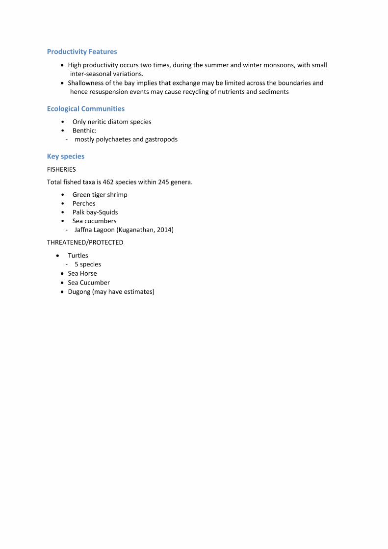
Total fished taxa is 462 species within 245 genera.
• Green tiger shrimp • Perches • Palk bay‐Squids • Sea cucumbers ‐ Jaffna Lagoon (Kuganathan, 2014)
THREATENED/PROTECTED
Turtles ‐ 5 species
Sea Horse Sea Cucumber
Dugong (may have estimates)

Figure 25 Habitat diagram of the Palk Bay Province showing selected features.
8.8.1 TRANS‐BOUNDARY LINKAGES
TBA

8.9 Coromandel Shelf Province
8.9.1 PROVINCE BOUNDARIES
The Sri Lanka Shelf and Slope in the south
The North East Indian Shelf and Slope to the north
The abyssal regions to the west
Diverse range of environment types from bay environment to narrow shelf
Different orientation to North East Indian Shelf
Drained by major river systems from the Deccan Plateau: Godavari, Krishna, Pennar and Cauvery
Changes in climate and weather proceeding from south to north and the size and location of catchments supplying river flow to the coast
Limited exchanges with the northern portion of the Sri Lanka shelf
Restricted exchange with the North East Indian Shelf
Exchanges with the Coromandel Slope from the shelf‐break front, eddies and upwellings
8.9.2 BIOPHYSICAL DRIVERS
Geomorphological Features
• Coastline ‐ Fairly straight (North‐South) coastline in the south and undulating (East‐West) towards
North • Lake ‐ Pulicat is a major brackish water lake (north of Chennai)
• Rivers ‐ 3 major rivers
• Delta system ‐ with minor rain fed /seasonal rivers
• Open beaches • Continental shelf ‐ width ranges between 30 km in the south off Pondicherry and widens to 50 km off Ongole
/ Nizamapattanam ‐ Small shelf basins towards northern shelf region
Figure 26 Coromandel Shelf and Slope Provinces.

Figure 27 Map of Coromandel Shelf and Slope geomorphology
Climate
• In the south rainfall dominate during North East Monsoon while in the north it is during South West Monsoon.
• Regular and strong cyclones associated with rainfall during April‐ May and Oct‐Nov (~2‐4 cyclones per year)
Oceanography
• East India Coastal Current (EICC) ‐ reverses once in a year; towards south during winter and towards north during summer ‐ high salinity during summer and low salinity during winter
• Eddies ‐ Cyclonic and Anticyclonic ‐ Quasi‐permanent cyclonic eddy at 16‐17 degrees E, near where an apparent slumped shelf
transitions from a narrow width to a wider shelf further north • Pelagic water masses (3 types) ‐ Low salinity BoB waters ‐ High salinity Arabian Sea Water ‐ Uniform salinity (well‐mixed) intermediate water
8.9.3 ECOLOGICAL ASSETS
Habitats
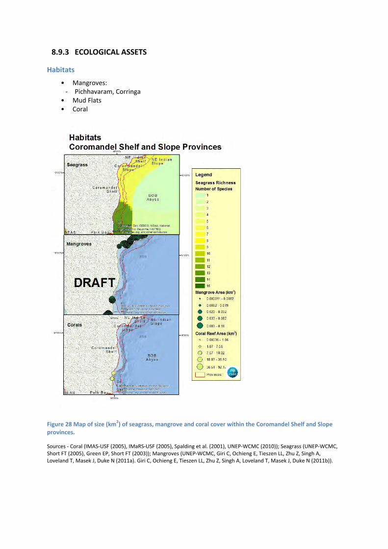
• Mangroves: ‐ Pichhavaram, Corringa
• Mud Flats • Coral
Figure 28 Map of size (km2) of seagrass, mangrove and coral cover within the Coromandel Shelf and Slope provinces.
Sources ‐ Coral (IMAS‐USF (2005), IMaRS‐USF (2005), Spalding et al. (2001), UNEP‐WCMC (2010)); Seagrass (UNEP‐WCMC, Short FT (2005), Green EP, Short FT (2003)); Mangroves (UNEP‐WCMC, Giri C, Ochieng E, Tieszen LL, Zhu Z, Singh A, Loveland T, Masek J, Duke N (2011a). Giri C, Ochieng E, Tieszen LL, Zhu Z, Singh A, Loveland T, Masek J, Duke N (2011b)).

Table 9 Size (km2) and habitat cover (%) for the Coromandel Shelf Province as a percentage of area covered. (*Note: Includes land and mangroves up to 30m elevation.)
HABITAT COROMANDEL SHELF PROVINCE % HABITAT COVER
Area (km2) 58,591
Land (%) 57.428*
Coral (%) 0.053
Mangroves (%) 0.282
Seagrass (%) 0.000
Sources – Coral (IMAS‐USF (2005), IMaRS‐USF (2005), Spalding et al. (2001), UNEP‐WCMC (2010)); Seagrass (UNEP‐WCMC, Short FT (2005), Green EP & Short FT (2003)); Mangroves (Giri et al. (2011a), Giri et al. (2011b))
Productivity Features
• Generally oligotrophic/Low productivity, occasional enhancement due to cyclonic eddies and cyclones
Ecological Communities
• Small pelagics: ‐ dominated ecosystem ‐ Oil sardine ‐ Lesser sardines ‐ Threadfin Breams ‐ Ribbon fishes ‐ Scads ‐ Silverbellies ‐ Mackerel
• Demersal: ‐ Penaeid shrimp ‐ Crabs ‐ Squids ‐ Cuttlefish ‐ Skates
• Benthic: ‐ Polychaetes (65% of benthic community; 33 species) ‐ Amphipods (25% of benthic community; 1 species) ‐ Gastropods (20% of benthic community; 3 species) ‐ Bivalves

Figure 29 Stylised benthic community of infaunal animals. Credit: Illustrators ‐ Wayne R. Davis and Virginia Lee (2003)
Key species
FISHED
~750 species belonging to 338 genera exploited from Coromandel shelf and slope provinces.
THREATENED/PROTECTED
Whales
Dolphins Sea birds Turtles

Figure 30 Schematic of the Coromandel Shelf and Slope Provinces.
8.9.4 TRANS‐BOUNDARY LINKAGES
Limited exchanges can be expected with the northern portion of the Sri Lanka shelf. The narrow Sri Lanka shelf further south and the shallow Palk Bay to the south west will limit exchanges due to dynamical constraints in moving from a relatively deep environment to a shallow one.
The passage from the Coromandel Shelf to the North East Indian Shelf is via a relatively narrow shelf region to the north of the Coromandel Shelf. Here again dynamical constraints would restrict exchanges between these provinces.
Exchanges with the Coromandel Slope may arise from the shelf‐break front at the edge of the continental shelf which extends offshore over the slope region and may result in a rain of organic material into the slope water column. Energetic features such as eddies and upwellings may also facilitate exchanges between these provinces.

8.10 Coromandel Slope Province
8.10.1 PROVINCE BOUNDARIES
As per Coromandel Shelf Province
Exchanges with the deep waters of the Bay of Bengal
8.10.2 BIOPHYSICAL DRIVERS
Geomorphological Features
• Escarpments • Canyons ‐ 8 canyons
• Continental slope ‐ narrow in mid regions, wide in the north side with no sea mounts or terraces
Climate
• In the south rainfall dominate during North East Monsoon while in the north it is during South West Monsoon.
• Regular and strong cyclones associated with rain fall during April‐ May and Oct‐Nov (~2‐4 cyclones per year)
Oceanography
• Surface circulation dominated by eddies
8.10.3 ECOLOGICAL ASSETS
Habitats
Table 10 Size (km2) and habitat cover (%) for the Coromandel Slope Province as a percentage of area covered. (*Note: Includes land and mangroves up to 30m elevation.)
HABITAT COROMANDEL SLOPE PROVINCE % HABITAT COVER
Area (km2) 28,276
Land (%) 0.000
Coral (%) 0.000
Mangroves (%) 0.000
Seagrass (%) 0.000
Sources – Coral (IMAS‐USF (2005), IMaRS‐USF (2005), Spalding et al. (2001), UNEP‐WCMC (2010)); Seagrass (UNEP‐WCMC, Short FT (2005), Green EP & Short FT (2003)); Mangroves (Giri et al. (2011a), Giri et al. (2011b))

Productivity Features
• Productivity determined by eddies • High productivity during cyclonic period
Ecological Communities
• Pelagics: ‐ Tunas ‐ Bill fishes ‐ Sharks
• Demersals: ‐ Polychaetes ‐ Gastropods ‐ Bivalves
Key species
FISHED
~750 species belonging to 338 genera exploited from Coramandel shelf and slope provinces.
THREATENED/PROTECTED
Whales
Dolphins Sea birds Turtles
8.10.4 TRANS‐BOUNDARY LINKAGES
See Trans‐boundary Linkages for Coromandel Shelf Province

8.11 North East Indian Shelf
8.11.1 PROVINCE BOUNDARIES
Unique north east shelf orientation in eastern India
Upwellings from south westerlies
Much of province lacks riverine drainage compared to Coromandel Shelf
Freshwater inflow from waters of the Ganges Shelf Province in the north
Exchanges with the Slope from the shelf‐break front, eddies and upwellings
8.11.2 BIOPHYSICAL DRIVERS
Figure 32 Map of North East Indian Shelf and Slope geomorphology.
Geomorphological Features
Narrow shelf grading relatively steeply into the slope and basin environment
Figure 31 North East Indian Shelf and Slope Provinces
Climate
• Highly vulnerable to cyclone impacts including coastal erosion and flooding • Large freshwater runoff from river systems during the Summer monsoonal period
Oceanography
TBA second workshop
8.11.3 ECOLOGICAL ASSETS
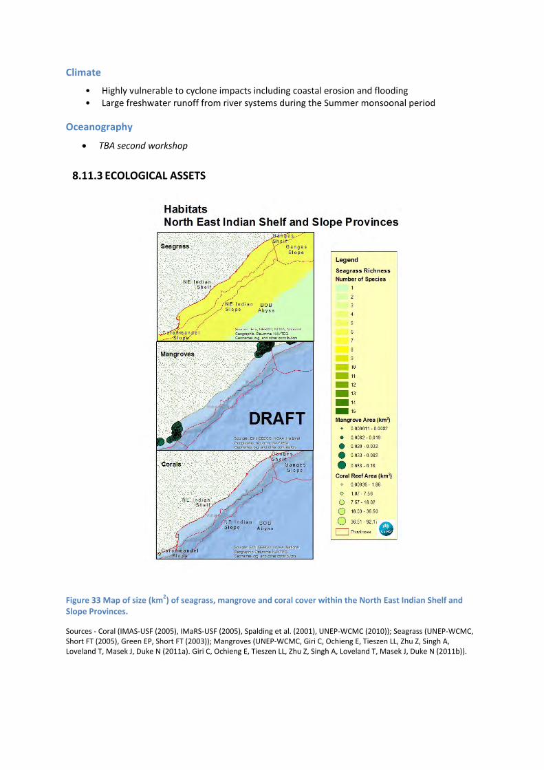
Figure 33 Map of size (km2) of seagrass, mangrove and coral cover within the North East Indian Shelf and Slope Provinces.
Sources ‐ Coral (IMAS‐USF (2005), IMaRS‐USF (2005), Spalding et al. (2001), UNEP‐WCMC (2010)); Seagrass (UNEP‐WCMC, Short FT (2005), Green EP, Short FT (2003)); Mangroves (UNEP‐WCMC, Giri C, Ochieng E, Tieszen LL, Zhu Z, Singh A, Loveland T, Masek J, Duke N (2011a). Giri C, Ochieng E, Tieszen LL, Zhu Z, Singh A, Loveland T, Masek J, Duke N (2011b)).
Habitats
• Mangroves • Seagrass • Fine sediment sea bed derived from mainly riverine input • Substantial mangrove and seagrass areas • Some deeper shelf valleys
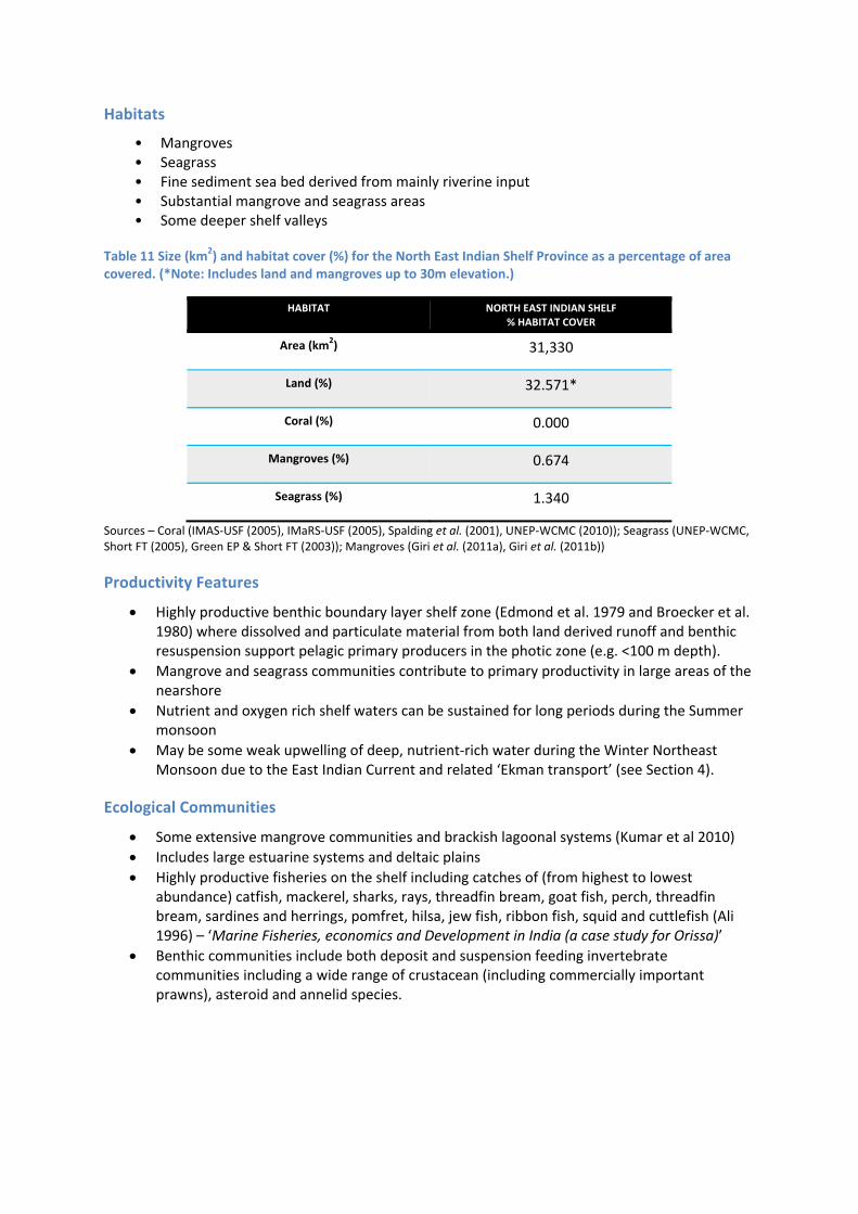
Table 11 Size (km2) and habitat cover (%) for the North East Indian Shelf Province as a percentage of area covered. (*Note: Includes land and mangroves up to 30m elevation.)
HABITAT NORTH EAST INDIAN SHELF % HABITAT COVER
Area (km2) 31,330
Land (%) 32.571*
Coral (%) 0.000
Mangroves (%) 0.674
Seagrass (%) 1.340
Sources – Coral (IMAS‐USF (2005), IMaRS‐USF (2005), Spalding et al. (2001), UNEP‐WCMC (2010)); Seagrass (UNEP‐WCMC, Short FT (2005), Green EP & Short FT (2003)); Mangroves (Giri et al. (2011a), Giri et al. (2011b))
Productivity Features
Highly productive benthic boundary layer shelf zone (Edmond et al. 1979 and Broecker et al. 1980) where dissolved and particulate material from both land derived runoff and benthic resuspension support pelagic primary producers in the photic zone (e.g. <100 m depth).
Mangrove and seagrass communities contribute to primary productivity in large areas of the nearshore
Nutrient and oxygen rich shelf waters can be sustained for long periods during the Summer monsoon
May be some weak upwelling of deep, nutrient‐rich water during the Winter Northeast Monsoon due to the East Indian Current and related ‘Ekman transport’ (see Section 4).
Ecological Communities
Some extensive mangrove communities and brackish lagoonal systems (Kumar et al 2010)
Includes large estuarine systems and deltaic plains
Highly productive fisheries on the shelf including catches of (from highest to lowest abundance) catfish, mackerel, sharks, rays, threadfin bream, goat fish, perch, threadfin bream, sardines and herrings, pomfret, hilsa, jew fish, ribbon fish, squid and cuttlefish (Ali 1996) – ‘Marine Fisheries, economics and Development in India (a case study for Orissa)’
Benthic communities include both deposit and suspension feeding invertebrate communities including a wide range of crustacean (including commercially important prawns), asteroid and annelid species.

Key species
THREATENED/PROTECTED
Turtles ‐ Large Olive Ridley sea turtle rookery on Sandy beach habitats
8.11.4 TRANS‐BOUNDARY LINKAGES
TBA

8.12 North East Indian Slope
8.12.1 PROVINCE BOUNDARIES
As per North East Indian Shelf Province
8.12.2 BIOPHYSICAL DRIVERS
Geomorphological Features
Narrow slope grading relatively steeply into the basin environment
Features include steep escarpments and canyons
Climate
Large freshwater runoff from river systems during the Summer monsoonal period
Oceanography
Some weak upwelling during the Winter Northeast Monsoon due to the East Indian Current flow
Local currents within and around canyon heads likely
8.12.3 ECOLOGICAL ASSETS
Habitats
Table 12 Size (km2) and habitat cover (%) for the North East Indian Slope Province as a percentage of area covered. (*Note: Includes land and mangroves up to 30m elevation.)
HABITAT NORTH EAST INDIAN SLOPE % HABITAT COVER
Area (km2) 14,174
Land (%) 0.000
Coral (%) 0.000
Mangroves (%) 0.000
Seagrass (%) 0.000
Sources – Coral (IMAS‐USF (2005), IMaRS‐USF (2005), Spalding et al. (2001), UNEP‐WCMC (2010)); Seagrass (UNEP‐WCMC, Short FT (2005), Green EP & Short FT (2003)); Mangroves (Giri et al. (2011a), Giri et al. (2011b))
Productivity Features
Nutrient and oxygen rich surface waters can be sustained for long periods during the Summer monsoon following heavy rain and coastal runoff
May be some weak upwelling of deep, nutrient‐rich water during the Winter Northeast Monsoon due to the East Indian Current and related ‘Ekman transport’ (see Section 4)
Ocean colour chlorophyll on the slope and offshore is high during SW Monsoon
Ecological Communities
Steep escarpments and canyons likely to support suspension feeding communities and associated bentho‐pelagic communities of invertebrates and fish
Areas of fine sediment where the slope gradient is weaker likely to support deposit feeding communities and benthic communities adapted to finer sediments
Productive pelagic zone likely to support schooling small pelagics including clupeids and small mackerels
Schooling fish species in pelagic habitats including mackerel, sardines and herrings
Demersal and epi‐pelagic communities including sharks, rays, threadfin bream, goat fish, perch, jew fish, ribbon fish, squid and cuttlefish
Benthic communities include both deposit and suspension feeding invertebrate communities including a wide range of crustacean (including commercially important prawns), asteroid and annelid species
Key species
TBA
8.12.4 TRANS‐BOUNDARY LINKAGES
TBA

8.13 Ganges Shelf Province
8.13.1 PROVINCE BOUNDARIES
Unique province containing outflows from the Ganges
Major source of freshwater, sediments, organics, nutrients and other materials discharged into the Bay of Bengal
Site of outflow for meltwaters from Himalaya – important for climate change studies
Source of sediments for the extensive and unique Bay of Bengal mud fan
Uniquely identified by delta topography and sedimentary features
Major source of turbidity into the Bay of Bengal limiting plankton productivity and binding organics
Western and eastern boundaries are narrower and oriented differently – implication for currents and exchanges
8.13.2 BIOPHYSICAL DRIVERS
Geomorphological Features
• Delta system: ‐ with rain fed /seasonal rivers ‐ Ganges basin contains the largest river system on the subcontinent ‐ water supply depends partly on the rains brought by the south‐westerly monsoon winds
from July to October, as well as on the flow from melting Himalayan snows in the hot season from April to June
‐ sediment flow into canyons • Open beaches • Canyons ‐ Canyons begin in shelf section, but majority of feature within the slope
Figure 34 Ganges Shelf and Slope Provinces

Figure 35 Map of Ganges Shelf and Slope geomorphology
Climate
• average annual rainfall varies from 30 inches (760 mm) at the western end of the basin to more than 90 inches (2,290 mm) at the eastern end
• strong cyclonic storms both before the commencement of the monsoon season, from March to May, and at the end of it, from September to October
Oceanography
• high current flow through canyons

8.13.3 ECOLOGICAL ASSETS
Figure 36 Map of size (km2) of seagrass, mangrove and coral cover within the Ganges Shelf and Slope Provinces.
Sources ‐ Coral (IMAS‐USF (2005), IMaRS‐USF (2005), Spalding et al. (2001), UNEP‐WCMC (2010)); Seagrass (UNEP‐WCMC, Short FT (2005), Green EP, Short FT (2003)); Mangroves (UNEP‐WCMC, Giri C, Ochieng E, Tieszen LL, Zhu Z, Singh A, Loveland T, Masek J, Duke N (2011a). Giri C, Ochieng E, Tieszen LL, Zhu Z, Singh A, Loveland T, Masek J, Duke N (2011b)).
Habitats
• Coral reef • Mangroves • Seagrass • Mudflats

Table 13 Size (km2) and habitat cover (%) for the Ganges Shelf Province as a percentage of area covered. (*Note: Includes land and mangroves up to 30m elevation.)
HABITAT GANGES SHELF PROVINCE % HABITAT COVER
Area (km2) 302,597
Land (%) 59.810*
Coral (%) 0.004
Mangroves (%) 2.236
Seagrass (%) 0.221
Sources – Coral (IMAS‐USF (2005), IMaRS‐USF (2005), Spalding et al. (2001), UNEP‐WCMC (2010)); Seagrass (UNEP‐WCMC, Short FT (2005), Green EP & Short FT (2003)); Mangroves (Giri et al. (2011a), Giri et al. (2011b))
Productivity Features
• Enhanced local and downstream productivity where boundary currents and internal waves/tides intersect with canyon resulting in a spilling out of higher nutrient cooler waters at their ends.
• Chlorophyll is high in the south west segment during the SW Monsoon • Turbidity caused by riverine outflow may attenuate productivity
Ecological Communities
• Pelagics: ‐ sardines
• Tidal: ‐ Catfish ‐ Hilsa
• Benthic: ‐ Polychaetes
• Coastal: ‐ Bombay duck
Key species
TBA

Figure 37 Habitat diagram of the Ganges Shelf Province showing selected features.
8.13.4 TRANS‐BOUNDARY LINKAGES
TBA

8.14 Ganges Slope Province
8.14.1 PROVINCE BOUNDARIES
As per Ganges Shelf Province
Active exchanges with deep waters through sedimentary processes
Incised by large canyons acting as conduits for mass sedimentary flows to deep ocean
Western and eastern boundaries are narrower and oriented differently – implication for currents and exchanges
Major pathway for Ganges outflow to the deep ocean
8.14.2 BIOPHYSICAL DRIVERS
Geomorphological Features
• Canyons ‐ ~6 large canyons
Climate
• average annual rainfall varies from 30 inches (760 mm) at the western end of the basin to more than 90 inches (2,290 mm) at the eastern end
• strong cyclonic storms both before the commencement of the monsoon season, from March to May, and at the end of it, from September to October
Oceanography
• high current flow through canyons • sediments settling and resuspension causes movement of sediments to deeper water • turbidity currents possible along canyons carrying sediments to deep water

8.14.3 ECOLOGICAL ASSETS
Habitats
Table 14 Size (km2) and habitat cover (%) for the Ganges Slope Province as a percentage of area covered. (*Note: Includes land and mangroves up to 30m elevation.)
HABITAT GANGES SLOPE PROVINCE % HABITAT COVER
Area (km2) 97,913
Land (%) 0.000
Coral (%) 0.000
Mangroves (%) 0.000
Seagrass (%) 0.000
Sources – Coral (IMAS‐USF (2005), IMaRS‐USF (2005), Spalding et al. (2001), UNEP‐WCMC (2010)); Seagrass (UNEP‐WCMC, Short FT (2005), Green EP & Short FT (2003)); Mangroves (Giri et al. (2011a), Giri et al. (2011b))
Productivity Features
• Enhanced local and downstream productivity where boundary currents and internal waves/tides intersect with canyon resulting in a spilling out of higher nutrient cooler waters at their ends.
Ecological Communities
• Pelagics: ‐ sardines
• Benthic: ‐ Polychaetes
Key species
TBA
8.14.4 TRANS‐BOUNDARY LINKAGES
TBA

8.15 Bay of Bengal Abyssal Province
8.15.1 PROVINCE BOUNDARIES
Unique abyssal province identified by its depth range (>2000 m)
Sub‐provinces identified by characteristics of Mud Fan and from analysis of pelagic water masses
Variable exchanges with continental boundaries, surface waters, seafloor geothermal processes, tectonic events and deep ocean circulation and mixing
o Ganges is main contributor to Bengal Fan o Rain of materials from surface processes
grades from Ganges to the southern boundary forming the Upper, Middle and Lower zones of the Bengal Fan
o Rain of productivity by‐products from monsoonal events; varies seasonally and regionally leading to seasonality in rain of material to deep ocean
Contains extensive reservoirs of oil, gas and mineral resources which may also contain regions of unique and rare species
8.15.2 BIOPHYSICAL DRIVERS
Geomorphological Features
large central deep water basin
deepens from north to south to >4000 m
sediment fan being deposited from the large river systems in the north.
world’s largest submarine sediment fan with an area of 2.8‐3.0 x 10⁶ km2 (Sarma et al, 2000)
extends from the Ganges/Brahmaputra delta, around 20° N latitude to south of 7° S, with a maximum width of about 1000 km around 15" N latitude (Figure 4.1, 4.3) and a maximum thickness of about 21 km at its apex in the Bangladesh offshore region
large canyon incising through the continental slope of the Ganges delta extends into the northern edge of the basin at about 500 m depth
isolated local high features occur on the seafloor south of 5oN (just south of the province)
with a positive relief of 500 to 900 m from the mean seabed. These features are associated with positive magnetic anomalies. (Sarma, K.V.L.N.S., M.V.Ramana , V.Subrahmanyam, K.S.Krishna , T.Ramprasad and Maria Desa. (2000) Morphological features in the Bay of Bengal. J. Ind. Geophys. Union Vol. 4, No.2, pp. 185‐190)
Figure 38 Bay of Bengal Abyssal Province

Figure 39 Map of Bay of Bengal Abyssal geomorphology.
Climate
TBA
Oceanography
Deep ocean salinity is very constant at about 35 ppt
temperatures are cold to around 5‐6oC below 1000 m and 0‐3oC below 3000 m and without any seasonal changes
there are no hydrothermal vents of other features that would alter temperature regimes
8.15.3 ECOLOGICAL ASSETS
Habitats
Dominated by fine, homogenous sediment
Main habitat gradients are related to depth and the influence of depth on water temperature

Table 15 Size (km2) and habitat cover (%) for the Ganges Slope Province as a percentage of area covered. (*Note: Includes land and mangroves up to 30m elevation.)
HABITAT GANGES SLOPE PROVINCE % HABITAT COVER
Area (km2) 1,597,680
Land (%) 0.000
Coral (%) 0.000
Mangroves (%) 0.000
Seagrass (%) 0.000
Sources – Coral (IMAS‐USF (2005), IMaRS‐USF (2005), Spalding et al. (2001), UNEP‐WCMC (2010)); Seagrass (UNEP‐WCMC, Short FT (2005), Green EP & Short FT (2003)); Mangroves (Giri et al. (2011a), Giri et al. (2011b))
Productivity Features
Energy for ecological communities and species is mainly from particulate living and dead organic matter (‘marine snow’) that sinks from the surface environments. These are derived from a wide range of sources including dead animals and plants, sloughed exoskeletons, faecal material, dislodged scales and other body parts.
Some whole carcasses of larger animals provide unique habitat for specific opportunistic species.
Ecological Communities
Communities dominated by deposit feeders and marine bacteriophages.
Some secondary and tertiary species, including bioluminescent species and those that use photophores.
Key species
TBA
8.15.4 TRANS‐BOUNDARY LINKAGES
TBA

8.16 Irrawaddy Province
8.16.1 PROVINCE BOUNDARIES
Unique province containing outflows from the Irrawaddy
Major source of freshwater, sediments, organics, nutrients and other materials discharged into the Andaman Sea
Uniquely identified by delta topography and sedimentary features
Wide shelf environment
Major source of turbidity into the Andaman Sea limiting plankton productivity and binding organics
Eastern boundary is a major site of exchange between the surface waters of the Bay of Bengal and the Andaman Sea
8.16.2 BIOPHYSICAL DRIVERS
Irrawaddy Delta is the second largest freshwater discharge of the Bay of Bengal. River occurs from
the northern part of Myanmar. Irrawaddy delta is 261 km wide and salinity ranges from 34‐32
Geomorphological Features
Deep basins (4039km2) from 77km
Shelf (53937km2)
Shelf valley (2.5%)
Slope (1000km2) 1.8%
Canyons‐ 556km2 (1%)
Couple of tiny islands
Muddy fine sand
River system
"The waters of these rivers are very turbid due to a heavy silt load they carry and the sea is very shallow with depths less than 5.5 m across the coastline and in the east for a distance of up to 28 km offshore. As a result of constant accretion into the sea, the delta is advancing at a rate of 5–6 km per 100 years, equivalent to about 1,000 hectares per year." Source: "Irrawaddy Delta". ARCBC (ASEAN Regional Centre for Biodiversity Conservation.
Annual discharge approximately 250 million tons of sediment
Google Earth image (Figure 41) shows a rich variety of depositional features associated with the outflow and deposition of sediments
Figure 40 Irrawaddy Province

Figure 41 Google Earth image of the Irrawaddy Delta showing depositional features emanating from the outflow to deep water. The white feature over the ocean appears to be cloud.
Figure 42 Map of Irrawaddy geomorphology

Climate
Annual rainfall is approximately 2500 mm
Humid tropical climate
Cyclone activity
SW Monsoon‐ May to October
Rainfall season: mid‐May to mid‐November
Cool and dry from mid‐October to mid‐February
Oceanography
Deep water and strong currents to the east of river mouth
Current strong during new and full moon
Water temperature 28‐29 degrees C, sometimes 20 degrees C as you go down
8.16.3 ECOLOGICAL ASSETS
Figure 43 Map of size (km2) of seagrass, mangrove and coral cover within the Alcock Rise and Irrawaddy Provinces.
Sources ‐ Coral (IMAS‐USF (2005), IMaRS‐USF (2005), Spalding et al. (2001), UNEP‐WCMC (2010)); Seagrass (UNEP‐WCMC, Short FT (2005), Green EP, Short FT (2003)); Mangroves (UNEP‐WCMC, Giri C, Ochieng E, Tieszen LL, Zhu Z, Singh A, Loveland T, Masek J, Duke N (2011a). Giri C, Ochieng E, Tieszen LL, Zhu Z, Singh A, Loveland T, Masek J, Duke N (2011b)).

Habitats
Mangroves and nipa palm are the major vegetation types
Freshwater swamp forests
Marshes
Mudflat
Sediment depositional forms
Table 16 Size (km2) and habitat cover (%) for the Irrawaddy Province as a percentage of area covered. (*Note: Includes land and mangroves up to 30m elevation.)
HABITAT IRRAWADDY PROVINCE % HABITAT COVER
Area (km2) 190,211
Land (%) 30.600*
Coral (%) 0.016
Mangroves (%) 0.673
Seagrass (%) 0.000
Sources – Coral (IMAS‐USF (2005), IMaRS‐USF (2005), Spalding et al. (2001), UNEP‐WCMC (2010)); Seagrass (UNEP‐WCMC, Short FT (2005), Green EP & Short FT (2003)); Mangroves (Giri et al. (2011a), Giri et al. (2011b))
Productivity Features
Water is alkaline
High benthic productivity
Many collaborative studies between India and Myanmar published in Indian Fisheries Journal (Ittakot Venn)
Ecological Communities
Mangrove communities
Mud infaunal communities
Suspension feeders
Seabirds: ‐ “Phalacrocorax carbo, a wide variety of Anatidae, Fulica atra, about 30 species of
migratory shorebirds, Chlidonias hybrida, Hydroprogne caspia, and the Brown‐headed Gull (Larus brunnicephalus), which is very common. One of the most numerous wintering shorebird is the Lesser Sand Plover (Charadrius mongolus), which occurs in flocks of many thousands along the outer coast of the delta. The Wood Sandpiper and Red Junglefowl (Tringa glareola) are also abundant." (Source: http://en.wikipedia.org/wiki/Irrawaddy_River)
Fish ‐ 43 freshwater fish species listed in:
http://fish.mongabay.com/data/ecosystems/Irrawaddy.htm

Key species
THREATENED/PROTECTED
Estuarine crocodile (Crocodylus porosus)
Turtles ‐ 5 species ‐ Green Turtle, Olive Ridley Turtle, Hawksbill Turtle, Loggerhead Turtle &
Leatherback Turtle
Irrawaddy dolphin (Orcaella brevirostris)
Figure 44 Habitat diagram of the Irrawaddy Province showing selected features.
8.16.4 TRANS‐BOUNDARY LINKAGES
TBA

8.17 Alcock Rise Province
8.17.1 PROVINCE BOUNDARIES
Unique wide slope environment down to 2000 m at the northern end of the Andaman Sea
Depositional environment for materials discharged from the Irrawaddy
Pathway for shelf materials to the deep ocean
Western end is a pathway for exchange with deep waters of the Bay of Bengal
Diverse set of geomorph types including deep incised canyons facilitating exchange with shelf
Likely to be a productive fisheries region and contain deep water endemics
8.17.2 BIOPHYSICAL DRIVERS
Figure 46 Map of Alcock Rise geomorphology.
Geomorphological Features
The northern slope region of the Anadaman Sea
Exposed at its western end to the connection with open ocean waters of the Bay of Bengal
Northern end of this province is exposed to the influence from the Irrawaddy Province
Figure 45 Alcock Rise Province

Part of the Burma Plate
Southern protrusion of this province contains a diverse set of geomorph types ‐ likely to be an area of higher diversity
Climate
Annual rainfall is approximately 2500 mm
Humid tropical climate
Cyclone activity
SW Monsoon‐ May to October
Rainfall season: mid‐May to mid‐November
Cool and dry from mid‐October to mid‐February
Oceanography
Little known
8.17.3 ECOLOGICAL ASSETS
Habitats
Table 17 Size (km2) and habitat cover (%) for the Alcock Rise Province as a percentage of area covered. (*Note: Includes land and mangroves up to 30m elevation.)
HABITAT ALCOCK RISE PROVINCE % HABITAT COVER
Area (km2) 55,928
Land (%) 0.012
Coral (%) 0.002
Mangroves (%) 0.000
Seagrass (%) 0.000
Sources – Coral (IMAS‐USF (2005), IMaRS‐USF (2005), Spalding et al. (2001), UNEP‐WCMC (2010)); Seagrass (UNEP‐WCMC, Short FT (2005), Green EP & Short FT (2003)); Mangroves (Giri et al. (2011a), Giri et al. (2011b))
Productivity Features
Climate driven mixing and productivity keyed to monsoons
Flow exchange between the Bay of Bengal and the Andaman Sea is likely to pass through the Alcock Rise Province ‐ expect high productivity due to this exchange
Noticable increase in chlorophyll concentration from July peaking around August to September and through to a rapid decline in October
Ecological Communities
Mud infaunal communities
Pelagic frontal communities
Seafloor scavengers
Suspension feeders

Key species
TBA
8.17.4 TRANS‐BOUNDARY LINKAGES
TBA

8.18 Andaman Abyss Province
8.18.1 PROVINCE BOUNDARIES
Unique semi‐enclosed abyssal province identified by its depth range (>2000 m)
Eastern landmass boundaries limit exchange to minor flows through the Straits of Malacca
Western Andaman Ridge boundary restricts exchanges of deep ocean waters of the Bay of Bengal, hence composition and dynamics of deep ocean are subject to local surface and deep exchanges
Nature of seafloor and deep waters likely to be influenced by geothermal processes, tectonic events and deep ocean circulation and mixing
Rain of productivity by‐products from monsoonal events; varies seasonally and regionally leading to seasonality in rain of material to deep ocean
May contains resources and regions of unique and rare deep ocean communities
8.18.2 BIOPHYSICAL DRIVERS
Figure 48 Map of Andaman Abyss geomorphology
Figure 47 Andaman Abyss and Sewell Rise Provinces

Geomorphological Features
Deep sea basin east of the Andaman Rise Province
Active tectonic plate subduction zone and earthquakes
Sandstone sediments weathered from subduction zone
Detrital sediments from local weathering and input from the Irrawaddy Province to the north
Uplifted escarpments on western side at subduction zone
Variable sea floor topography
High relief escarpment runs along the western edge
Climate
Long summer monsoon (~ 160 d)
Timing and length of summer monsoon extremely variable
Timing of summer monsoon influenced by anomalous remote moisture sources in the Bay of Bengal and Arabian Sea.
Strong July‐August Somali Jet current causes earlier onset of summer monsoon
Based on (Misra and Di Napoli 2014)
Oceanography
Wind‐driven and very dynamic
Large tidal range (2 – 5m)
Periodic sea level depression during periods of high atmospheric pressure and strong monsoonal winds.
Internal wave occurs at depth of pycnochne (60 – 300 m)
Periodic tsunamis
Stratified water column with low dissolved oxygen below thermocline
Exchange currents occur across the Andaman Ridge
8.18.3 ECOLOGICAL ASSETS
Habitats
Table 18 Size (km2) and habitat cover (%) for the Andaman Abyss Province as a percentage of area covered (note: Mangroves includes up to 30m elevation).
HABITAT ANDAMAN ABYSS PROVINCE % HABITAT COVER
Area (km2) 146,890
Land (%) 0.005
Coral (%) 0.000
Mangroves (%) 0.000
Seagrass (%) 0.000
Sources – Coral (IMAS‐USF (2005), IMaRS‐USF (2005), Spalding et al. (2001), UNEP‐WCMC (2010)); Seagrass (UNEP‐WCMC, Short FT (2005), Green EP & Short FT (2003)); Mangroves (Giri et al. (2011a), Giri et al. (2011b))

Productivity Features
Climate driven mixing and productivity keyed to monsoons
Flow exchange between the Bay of Bengal and the Andaman Sea is likely to pass through the Alcock Rise Province and into Andaman Abyss Province providing detrital inputs and nutrient exchange
Andaman Gyre
Chlorophyll plumes emanate from seepage eastward south of the Andaman and Nicobar Islands during July. Plumes also apparent in the north western segment of this province from the entrance connecting to the Bay of Bengal. By September the plumes subside
From December to March, the southern portion of this province experiences enhanced productivity presumably from the NE Monsoon
Ecological Communities
Mud and sandy mud infaunal communities
Pelagic frontal communities
Seafloor scavengers
Suspension feeders
Key species
Pelagic fishes
8.18.4 TRANS‐BOUNDARY LINKAGES
TBA
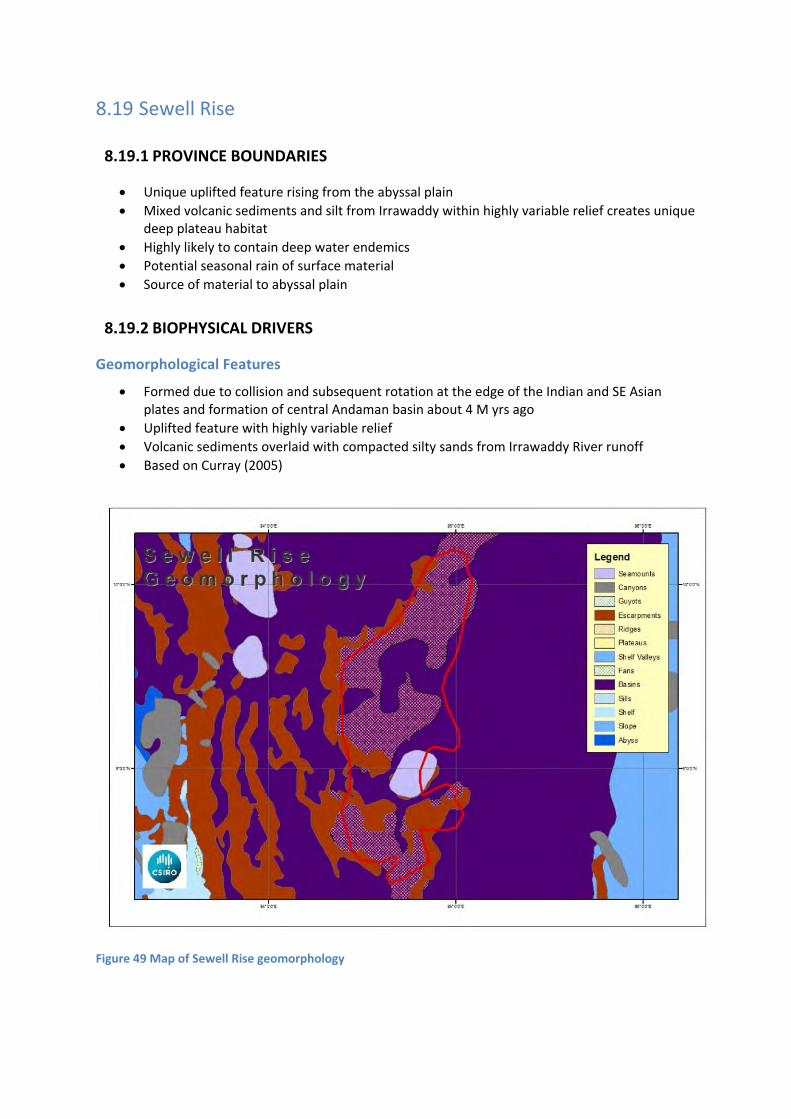
8.19 Sewell Rise
8.19.1 PROVINCE BOUNDARIES
Unique uplifted feature rising from the abyssal plain
Mixed volcanic sediments and silt from Irrawaddy within highly variable relief creates unique deep plateau habitat
Highly likely to contain deep water endemics
Potential seasonal rain of surface material
Source of material to abyssal plain
8.19.2 BIOPHYSICAL DRIVERS
Geomorphological Features
Formed due to collision and subsequent rotation at the edge of the Indian and SE Asian plates and formation of central Andaman basin about 4 M yrs ago
Uplifted feature with highly variable relief
Volcanic sediments overlaid with compacted silty sands from Irrawaddy River runoff
Based on Curray (2005)
Figure 49 Map of Sewell Rise geomorphology

Climate
Long summer monsoon (~ 160 d)
Timing and length of summer monsoon extremely variable
Timing of summer monsoon influenced by anomalous remote moisture sources in the Bay of Bengal and Arabian Sea.
Strong July‐August Somali Jet current causes earlier onset of summer monsoon
Based on Misra and Di Napoli 2014
Oceanography
Wind‐driven and very dynamic
Large tidal range (2 – 5m)
Periodic sea level depression during periods of high atmospheric pressure and strong monsoonal winds.
Periodic tsunamis
Stratified water column with low dissolved oxygen below thermocline
Andaman Gyre
8.19.3 ECOLOGICAL ASSETS
Habitats
Table 19 Size (km2) and habitat cover (%) for the Sewell Rise Province as a percentage of area covered (note: Mangroves includes up to 30m elevation). *High percent land cover due to mangrove/river systems, etc.
HABITAT SEWELL RISE PROVINCE % HABITAT COVER
Area (km2) 9,477
Land (%) 0.000
Coral (%) 0.000
Mangroves (%) 0.000
Seagrass (%) 0.000
Sources – Coral (IMAS‐USF (2005), ImaRS‐USF (2005), Spalding et al. (2001), UNEP‐WCMC (2010)); Seagrass (UNEP‐WCMC, Short FT (2005), Green EP & Short FT (2003)); Mangroves (Giri et al. (2011a), Giri et al. (2011b))
Productivity Features
Andaman Gyre
Complex wind and tidally‐drive currents due to topography
Being at the core of the Andaman Sea, this region is likely to experience, and rely upon, depositional and settling events as sources of organic matter
Ecological Communities
Mud and sandy mud infaunal communities
Pelagic frontal communities
Seafloor scavengers
Suspension feeders

Key species
TBA
8.19.4 TRANS‐BOUNDARY LINKAGES
TBA

8.20 Nicobar‐Andaman Ridge Province
8.20.1 PROVINCE BOUNDARIES
Unique ocean ridge system down to 2000m depth separating the deep waters of the Bay of Bengal from the Andaman Sea
Deep nutrient‐rich water upwells and exchanges as monsoonal currents flow over ridge
Connects to the south west Myanmar continental slope and shelf in the north, and part of the Irrawaddy slope and shelf
Important topographic feature for productivity going into both Andaman Sea and Bay of Bengal
Allows deep water species to interact with deep ocean, and with south west Myanmar continental margin
Important coral habitat environment located in deep water and subject to tectonic and volcanic activity
8.20.2 BIOPHYSICAL DRIVERS
Figure 51 Map of Nicobar‐Andaman Ridge geomorphology
Figure 50 Nicobar‐Andaman Ridge Province

Geomorphological Features
Islands Escarpments
Basins Canyons Seafloor to 2000m depth
Separates and partly forms a barrier between the Bay of Bengal and the Andaman Sea
Climate
dry during the north‐east, and very wet during the south‐west, monsoons
Oceanography
Freshwater and sediment plume from island
Monsoonal winds appear to drive an exchange of water from the Bay of Bengal into the Andaman Sea during the SW Monsoon
Exchange across the ridge likely to induce upwelling and exchange of nutrients between the seas on either side
8.20.3 ECOLOGICAL ASSETS
Habitats
Corals Mangroves
Seagrass
Table 20 Size (km2) and habitat cover (%) for the Nicobar‐Andaman Ridge Province as a percentage of area covered. (*Note: Includes land and mangroves up to 30m elevation.)
HABITAT NICOBAR‐ANDAMAN RIDGE PROVINCE % HABITAT COVER
Area (km2) 252,174
Land (%) 3.021
Coral (%) 0.257
Mangroves (%) 0.251
Seagrass (%) 0.653
Sources – Coral (IMAS‐USF (2005), IMaRS‐USF (2005), Spalding et al. (2001), UNEP‐WCMC (2010)); Seagrass (UNEP‐WCMC, Short FT (2005), Green EP & Short FT (2003)); Mangroves (Giri et al. (2011a), Giri et al. (2011b))

Figure 52 Map of size (km2) of seagrass, mangrove and coral cover within the Nicobar‐Andaman Ridge Province
Sources ‐ Coral (IMAS‐USF (2005), IMaRS‐USF (2005), Spalding et al. (2001), UNEP‐WCMC (2010)); Seagrass (UNEP‐WCMC, Short FT (2005), Green EP, Short FT (2003)); Mangroves (UNEP‐WCMC, Giri C, Ochieng E, Tieszen LL, Zhu Z, Singh A, Loveland T, Masek J, Duke N (2011a). Giri C, Ochieng E, Tieszen LL, Zhu Z, Singh A, Loveland T, Masek J, Duke N (2011b)).
Productivity Features
Exchange from southern Andaman Sea into the Bay of Bengal is evident from chlorophyll plumes during December to about March
Exchanges into the Andaman Sea occur north and south of the Andaman and Nicobar Islands during the SW Monsoon
Ecological Communities
• Small pelagics: ‐ Clupeoids
• Medium pelagics: ‐ Mackerels

Key species
TBA
Figure 53 Habitat diagram of the Nicobar‐Andaman Ridge Province showing selected features.
8.20.4 TRANS‐BOUNDARY LINKAGES
TBA

8.21 North West Myanmar Shelf Province
8.21.1 PROVINCE BOUNDARIES
Shelf province bordering the extensive forest ranges of western Myanmar
Diverse coastal habitats: deltas, lagoons, mudflats, volcanic mounds and islands, drowned valleys and offshore islands; under the influence of seasonal riverine outflows and sediments
Influenced by the Ganges outflows in the north
At the confluence of the surface waters of the Bay of Bengal and the Andaman Sea in the south, and reduced influence from the Ganges
Exchanges with the central deep ocean Bay of Bengal and the continental slope in the west
Likely to be an area of unique habitats and endemic communities, but also a region of productive fisheries
8.21.2 BIOPHYSICAL DRIVERS
Figure 55 Map of North West Myanmar Shelf and Slope geomorphology.
Figure 54 North West Myanmar Shelf and Slope Provinces

Geomorphological Features
The North West Myanmar (NWM) Shelf (and Slope) are part of the West Burma Scarp (Nielsen et al., 2004) which extends from the northern boundary of this province past the southern boundary to about 14oN. The shelf width of NWM province varies from approximately 70 ‐ 90 km in the northern portion and narrows down to 25 ‐ 40 km in the southern portion. The Cheduba Island (18o40' ‐ 18o54' N) effectively "chokes" the shelf and funnels water and species flow around the island. The "choking" action could also lead to more rapid flow around the island from the funnelling effect. Similarly, southerly flows would be enhanced while northerly flow would decelerate upon entering the wider shelf ‐ leading us to postulate that at times a frontal zone may exist at the boundary zone between the wider northern and narrower southern segments of the province.
North of Cheduba Island, in the northern portion of the province, the coastline is highly fragmented and low lying, with evidence in Google Earth imagery of silty outflows at the mouth of delta systems. A number of small conical islands are also dotted in this segment of the province. The environment and presumably habitats in the northern portion would appear to be more diverse than those in the south.
The southern section NWM appears to have been shaped by the so‐called Watthe Avalanche (Nielsen et al., 2004) which led to the collapse of the shelf (see Figure 56).
Figure 56 The Watthe Avalanche and its debris cone ‐ from Nielsen et al. (2004): "Mud volcanoes are in grey, black dotted lines are normal faults, black line is the strike‐slip fault that generated the avalanche, and grey dotted lines are fold axis. Bathymetric data are contoured every 20 m.

Climate
Prevailing South West Monsoon.
Located near the coastal highland with fast flowing coastal rivers.
Influenced by cyclonic winds that blows North westerly direction
Oceanography
Tsunami prone area
Salinity: 18ppt in Wet season (SW Monsoon from May to Oct.) and 34 ppt during Dry season (Nov – April)
Deceleration and acceleration of flows at the abrupt change in shelf width and around the Cheduba Island
Complex circulation processes in the highly fragmented northern coast
Steep shelf break most likely the site of upwelling and frontal processes
Upwelling and fisheries hotspots possible in the lee of flow around islands
8.21.3 ECOLOGICAL ASSETS
Habitats
Mangrove confined to shallow muddy coastal and sheltered areas ‐ particularly to the northern segment
Extensive mudflats and delta systems in the northern segment
Seagrass is found in shallow coastal area in the northern area of the region. seagrass beds found in Gwa and Maung – Shwe – Lay‐Gyaing (in Rakhine state Part of NW Myanmar)
Coral reefs = 51 species belonging to 20 families and 30 genera
Isolated conical islands
Niche habitats likely amongst the fragmented and complex coastline of the north
Table 21 Size (km2) and habitat cover (%) for the North West Myanmar Shelf Province as a percentage of area covered. (*Note: Includes land and mangroves up to 30m elevation.)
HABITAT NORTH WEST MYANMAR SHELF PROVINCE % HABITAT COVER
Area (km2) 34,846
Land (%) 21.280*
Coral (%) 1.039
Mangroves (%) 3.986
Seagrass (%) 5.251
Sources – Coral (IMAS‐USF (2005), IMaRS‐USF (2005), Spalding et al. (2001), UNEP‐WCMC (2010)); Seagrass (UNEP‐WCMC, Short FT (2005), Green EP & Short FT (2003)); Mangroves (Giri et al. (2011a), Giri et al. (2011b))

Figure 57 Map of size (km2) of seagrass, mangrove and coral cover within the NW Myanmar Shelf and Slope provinces.
Sources ‐ Coral (IMAS‐USF (2005), IMaRS‐USF (2005), Spalding et al. (2001), UNEP‐WCMC (2010)); Seagrass (UNEP‐WCMC, Short FT (2005), Green EP, Short FT (2003)); Mangroves (UNEP‐WCMC, Giri C, Ochieng E, Tieszen LL, Zhu Z, Singh A, Loveland T, Masek J, Duke N (2011a). Giri C, Ochieng E, Tieszen LL, Zhu Z, Singh A, Loveland T, Masek J, Duke N (2011b)).
Productivity Features
Influence by monsoon and cyclone
Local upwelling in dry season (Nov. to April)
Organic production is high during dry season
Ecological Communities
Shrimp, barramundi, red snapper, chinese promfret, scad, tuna (yellow fin, tongol, eastern little tuna, frigate tuna), threadfin bream, indian mackerel, indo pacific mackerel, anchovy, sardines, lizard fish, big eye fish, round scad, trevallies, hilsa, squid, mud crab, mangrove crab

Key species
THREATENED/PROTECTED
Estuarine crocodile (Crocodylus porosus)
Turtles ‐ 5 species ‐ Green Turtle, Olive Ridley Turtle, Hawksbill Turtle, Loggerhead Turtle &
Leatherback Turtle
Dugongs
Figure 58 Draft schematic of the North West Myanmar Shelf and Slope Provinces
8.21.4 TRANS‐BOUNDARY LINKAGES
TBA

8.22 North West Myanmar Slope
8.22.1 PROVINCE BOUNDARIES
As per North West Myanmar Shelf
Of variable width and slope angle: narrow and steep in the south and wider and less steep in the north
Higher rates of sedimentation and productivity fallout likely in the north, and lesser south of the Cheduba Island where the shelf width is narrow and constricted
Confluence of environments and species in the south where waters of this province mix with those from the Bay of Bengal and the Andaman Sea
8.22.2 BIOPHYSICAL DRIVERS
Geomorphological Features
Canyons ‐ incised canyons ‐ active faults/folds
Debris Fields ‐ flow deposited from canyons
Mud Volcanoes
Seamounts
Escarpment
Basin
Plateau
Rise
Shelf valleys
Abyssal hills
Avalanche blocks ‐ on the Bengal Abyss at the foot of the slope
Located on the Sunda – Andaman trench
Sections across the shelf‐slope show the presence of a narrow and unusally sharp slope break (Nielsen et al., 2004)
Remobilisation of sediments from 2004 Tsunami (Rangin et al., 2006) (Rangin, C., Chamot‐Rooke, N., Khin Maung Kyi, U., Zitter, T., Than Min, U., Bengal Team)
Deformation at the northern tip of the Sunda trench: Giant landslides and active bending normal fault at the termination of the Sumatra earthquake rupture. European Geosciences Union. General Assembly 2006. Presentation: EGU06‐A‐06217; TS4.2‐1FR1O‐003.
Climate
Prevailing South West Monsoon.
Intrusion of fresh water during monsoon.
Influence by cyclonic winds
Oceanography
Natural hydrocarbon deposits
Turbidity currents and avalanches carrying sediments to lower slope
Upwelling processes at the shelf‐break front

8.22.3 ECOLOGICAL ASSETS
Habitats
Table 22 Size (km2) and habitat cover (%) for the North West Myanmar Slope Province as a percentage of area covered. (*Note: Includes land and mangroves up to 30m elevation.)
HABITAT NORTH WEST MYANMAR SLOPE PROVINCE % HABITAT COVER
Area (km2) 16,021
Land (%) 0.000
Coral (%) 0.000
Mangroves (%) 0.000
Seagrass (%) 0.000
Sources – Coral (IMAS‐USF (2005), IMaRS‐USF (2005), Spalding et al. (2001), UNEP‐WCMC (2010)); Seagrass (UNEP‐WCMC, Short FT (2005), Green EP & Short FT (2003)); Mangroves (Giri et al. (2011a), Giri et al. (2011b))
Productivity Features
Major site of productivity likely to be the upper slope at the shelf‐break front
Upwelling and downwelling processes within canyons
Potential for current systems and eddies along the shelf‐slope boundary, particularly at choke point locations such as the Cheduba Island
Ecological Communities
Pelagics: ‐ tuna (yellow fin, tongol, eastern little tuna, frigate tuna), indian mackerel, marlin ‐ Aggregation of pelagic species at sites of upwelling
Deep sea demersals: ‐ fish ( Pristedon weberi, Cholorophathalmus sp., Palinurichtus pringiei) ‐ shrimp (Heterocarpus woodmasoni, Parapandalus spinipes)
Other demersals: ‐ Lobster ( Puerulus sewelli)
Plankton filter feeding communities on upper slope
Scavenging communities within canyons along the sides and axis, and at the foot of the slope
Infauna communities within debris field and mud volcano neighbourhood
Key species
THREATENED/PROTECTED
Turtles ‐ 5 species ‐ Green Turtle, Olive Ridley Turtle, Hawksbill Turtle, Loggerhead Turtle &
Leatherback Turtle
Blue Whale

8.22.4 TRANS‐BOUNDARY LINKAGES
TBA

8.23 Myanmar Province
8.23.1 PROVINCE BOUNDARIES
Uniquely identified by the many offshore islands and highly fragmented nature of the coastline
Exchanges with the Irrawaddy Province in the north and the Straits of Malacca in the south
Gradation of freshwater and sedimentary influence from the north and Malacca waters in the south, combined with the diversity of coastal and offshore habitats creates environments suited to a wide variety of species and communities
Likely to be an area of high diversity and ecological importance
8.23.2 BIOPHYSICAL DRIVERS
Figure 60 Map of Myanmar geomorphology.
Figure 59 Myanmar Province
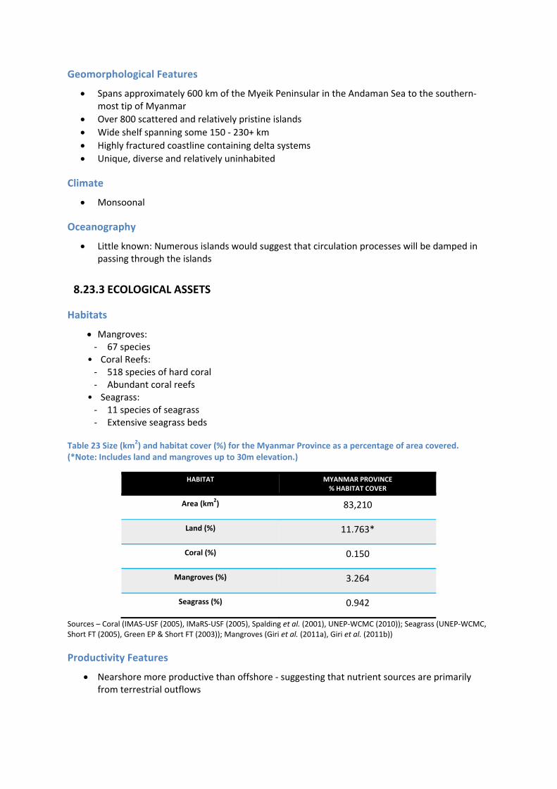
Geomorphological Features
Spans approximately 600 km of the Myeik Peninsular in the Andaman Sea to the southern‐most tip of Myanmar
Over 800 scattered and relatively pristine islands
Wide shelf spanning some 150 ‐ 230+ km
Highly fractured coastline containing delta systems
Unique, diverse and relatively uninhabited
Climate
Monsoonal
Oceanography
Little known: Numerous islands would suggest that circulation processes will be damped in passing through the islands
8.23.3 ECOLOGICAL ASSETS
Habitats
Mangroves: ‐ 67 species
• Coral Reefs: ‐ 518 species of hard coral ‐ Abundant coral reefs
• Seagrass: ‐ 11 species of seagrass ‐ Extensive seagrass beds
Table 23 Size (km2) and habitat cover (%) for the Myanmar Province as a percentage of area covered. (*Note: Includes land and mangroves up to 30m elevation.)
HABITAT MYANMAR PROVINCE% HABITAT COVER
Area (km2) 83,210
Land (%) 11.763*
Coral (%) 0.150
Mangroves (%) 3.264
Seagrass (%) 0.942
Sources – Coral (IMAS‐USF (2005), IMaRS‐USF (2005), Spalding et al. (2001), UNEP‐WCMC (2010)); Seagrass (UNEP‐WCMC, Short FT (2005), Green EP & Short FT (2003)); Mangroves (Giri et al. (2011a), Giri et al. (2011b))
Productivity Features
Nearshore more productive than offshore ‐ suggesting that nutrient sources are primarily from terrestrial outflows

Ecological Communities
Mangrove communities
Coral communities
Seagrass communities
Benthic species ‐ Arrow worms, larvaceans (appendicularians), siphonophores and chondrophores and
decapods
Demersal species ‐ Jelly fishes (white and red), horseshoe crab, shrimps, crabs, mantis shrimps, squids and
echinoderms
Key species
High diversity of sharks and rays; province contains a Marine Protected Area
113 fished species in 62 families
FISHERIES
sea cucumber
molluscs
Indian mackerel
Scad
Grouper
Snapper
spiny lobster
tuna
sardine
pearl farming
THREATENED/PROTECTED
Turtles ‐ 5 species ‐ Green Turtle, Olive Ridley Turtle, Hawksbill Turtle, Loggerhead Turtle &
Leatherback Turtle
Longman’s beaked whale (Indopacetus pacificus)
Dugong
Dolphins

Figure 61 Draft schematic of the Myanmar Province (transect through Similian – Andaman Sea).
8.23.4 TRANS‐BOUNDARY LINKAGES
TBA
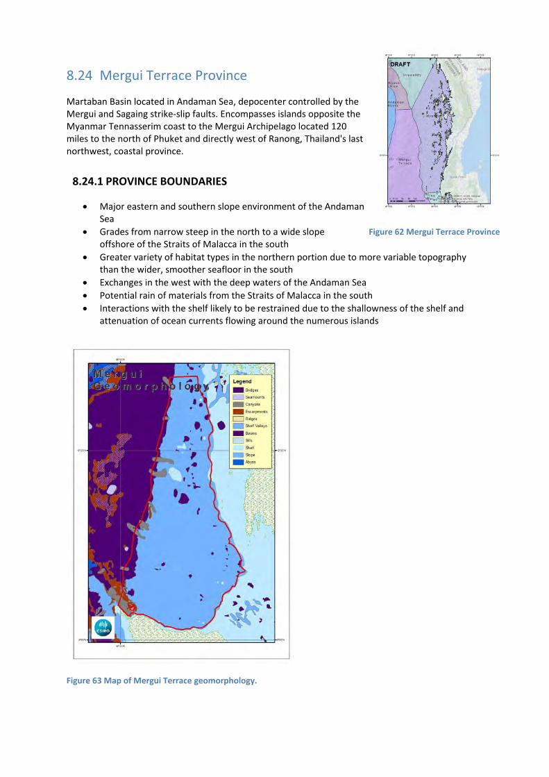
8.24 Mergui Terrace Province
Martaban Basin located in Andaman Sea, depocenter controlled by the Mergui and Sagaing strike‐slip faults. Encompasses islands opposite the Myanmar Tennasserim coast to the Mergui Archipelago located 120 miles to the north of Phuket and directly west of Ranong, Thailand's last northwest, coastal province.
8.24.1 PROVINCE BOUNDARIES
Major eastern and southern slope environment of the Andaman Sea
Grades from narrow steep in the north to a wide slope offshore of the Straits of Malacca in the south
Greater variety of habitat types in the northern portion due to more variable topography than the wider, smoother seafloor in the south
Exchanges in the west with the deep waters of the Andaman Sea
Potential rain of materials from the Straits of Malacca in the south
Interactions with the shelf likely to be restrained due to the shallowness of the shelf and attenuation of ocean currents flowing around the numerous islands
Figure 63 Map of Mergui Terrace geomorphology.
Figure 62 Mergui Terrace Province

8.24.2 BIOPHYSICAL DRIVERS
Geomorphological Features
Martaban Basin ‐ Back a‐arc strike slip and extension basin ‐ Depocenter controlled by Mergui and Sagaing strike‐slip faults
5 structural basin provinces ‐ Volcanic arc uplift belt ‐ West slope belt ‐ Centre depression belt ‐ East slope belt ‐ Mergui terrace
Myanmar Tennasserim coast ‐ ~800 islands opposite coast
By comparison to other slope environments, the slope here is relatively gentle
Width expands from approximately 70 km in the north to 200 km in the south
Contains relict carbonates of late Pleistocene age
Climate
Monsoonal
Oceanography
Tidal ‐ Range up to 4m ‐ Strong currents in shallow areas and narrow passages ‐ Tidal flow causes short, sharp chop when wind and tide are opposing
River sources ‐ Irrawaddy ‐ Salween
Little known; expect the change in slope width to effect circulation
Cross‐shelf processes important to sediment, larvae and particulate transport
8.24.3 ECOLOGICAL ASSETS
Habitats
Mergui Archipelago ‐ coral reef reserves ‐ sea grass beds ‐ old‐growth mangrove habitats

Table 24 Size (km2) and habitat cover (%) for the Mergui Terrace Province as a percentage of area covered. (*Note: Includes land and mangroves up to 30m elevation.)
HABITAT MERGUI TERRACE PROVINCE % HABITAT COVER
Area (km2) 150,243
Land (%) 0.083
Coral (%) 0.008
Mangroves (%) 0.000
Seagrass (%) 0.000
Sources – Coral (IMAS‐USF (2005), IMaRS‐USF (2005), Spalding et al. (2001), UNEP‐WCMC (2010)); Seagrass (UNEP‐WCMC, Short FT (2005), Green EP & Short FT (2003)); Mangroves (Giri et al. (2011a), Giri et al. (2011b))
Productivity Features
Sediments contain about 0.5% organic carbon
Slow deposition rates and low clay content suggests low productivity environment
This is consistent with productivity derived from terrestrial sources being depleted in passage to offshore regions
Mergui Archipelago ‐ most highly productive fishing grounds in the Bay of Bengal
Ecological Communities
Sharks, dolphins, manta rays, mobula rays
Dolphins, grey reef shark, nurse shark, blotched sting rays, manta rays, mobula (devil) rays, frogfish, ghost pipefish, ribbon eels
Crustaceans (lobsters, crabs, shrimps)
Mud infaunal communities
Coral communities
Scavenging communities
Benthic species ‐ Arrow worms, larvaceans (appendicularians), siphonophores and chondrophores and
decapods
Demersal species ‐ Jelly fishes (white and red), horseshoe crab, shrimps, crabs, mantis shrimps, squids and
echinoderms
Key species
FISHERIES
sea cucumber
molluscs
Indian mackerel
Scad
Grouper

Snapper
spiny lobster
tuna
sardine
THREATENED/PROTECTED
Turtles ‐ 5 species ‐ Green Turtle, Olive Ridley Turtle, Hawksbill Turtle, Loggerhead Turtle &
Leatherback Turtle
Whales ‐ Longman’s beaked whale (Indopacetus pacificus), sperm whale, humpback whale
Dolphins
8.24.4 TRANS‐BOUNDARY LINKAGES
TBA

8.25 Strait of Malacca Province
Transect from Medan, Sumatera to the Kuala Sepetang, Perak, Malaysia
8.25.1 PROVINCE BOUNDARIES
Bounded in the north west by a wide boundary shared with the Andaman Sea, and a narrow boundary to the south linking the Indian and Pacific oceans
Extensive and high diversity of coastline environments around the Strait
Shallowness of the strait prevents throughflow and active exchanges between waters at opposing ends
Flow and mixing in the Strait likely to be highly seasonal
8.25.2 BIOPHYSICAL DRIVERS
Figure 65 Map of Strait of Malacca geomorphology.
Geomorphological Feature
Bathymetry ‐ average depth ~53 m ‐ average depth north 66 m, average depth of the south 40 m
Bottom type ‐ muddy flats
Width of the strait widens going south to north
Figure 64 Strait of Malacca Province

Climate
Prevailing south west monsoon
Oceanography
Currents ‐ Summer season ‐ north to south ‐ Winter Season ‐ south to north ‐ current range 0.09 – 0.74 m/s ‐ stronger current northern region than south
Sea Surface Temperature ‐ 28‐31°C
8.25.3 ECOLOGICAL ASSETS
Figure 66 Map of size (km2) of seagrass, mangrove and coral cover within the Strait of Malacca province.
Sources ‐ Coral (IMAS‐USF (2005), IMaRS‐USF (2005), Spalding et al. (2001), UNEP‐WCMC (2010)); Seagrass (UNEP‐WCMC, Short FT (2005), Green EP, Short FT (2003)); Mangroves (UNEP‐WCMC, Giri C, Ochieng E, Tieszen LL, Zhu Z, Singh A, Loveland T, Masek J, Duke N (2011a). Giri C, Ochieng E, Tieszen LL, Zhu Z, Singh A, Loveland T, Masek J, Duke N (2011b)).

Habitats
Western side of mainland Malaysia ‐ mangrove
Eastern of Sumatra ‐ mangrove in the northern ‐ sea grass in the south
Table 25 Size (km2) and habitat cover (%) for the Strait of Malacca Province as a percentage of area covered. (*Note: Includes land and mangroves up to 30m elevation.)
HABITAT STRAIT OF MALACCA PROVINCE % HABITAT COVER
Area (km2) 279,527
Land (%) 37.987*
Coral (%) 0.025
Mangroves (%) 1.500
Seagrass (%) 0.507
Sources – Coral (IMAS‐USF (2005), IMaRS‐USF (2005), Spalding et al. (2001), UNEP‐WCMC (2010)); Seagrass (UNEP‐WCMC, Short FT (2005), Green EP & Short FT (2003)); Mangroves (Giri et al. (2011a), Giri et al. (2011b))
Productivity Features
Gradation of high apparent chlorophyll reducing from the south to the north suggests upwelling originates from the south into this province
Seasonal upwelling ‐ Summer, northern part of the strait of Malacca
‐ from January to March, a wide plume of chlorophyll appears to flow from the north eastern segment of this province across to the north west where it flows across the Andaman Ridge
Chorophyll a ‐ average 1mg/cubic meter, highest at 2mg/cubic meter
Ecological Communities
Eastern coast of Sumatra ‐ Banana prawns, penaeid shrimp, cockle, travelly, squids, silver pompret, thread fins,
mackerel
Western Coast of Malaysia ‐ Cockle, paniead prawn, anchovy, Acetes squids
Demersal species ‐ Leignathus, Upaneus, Pontaprion ‐ Rays
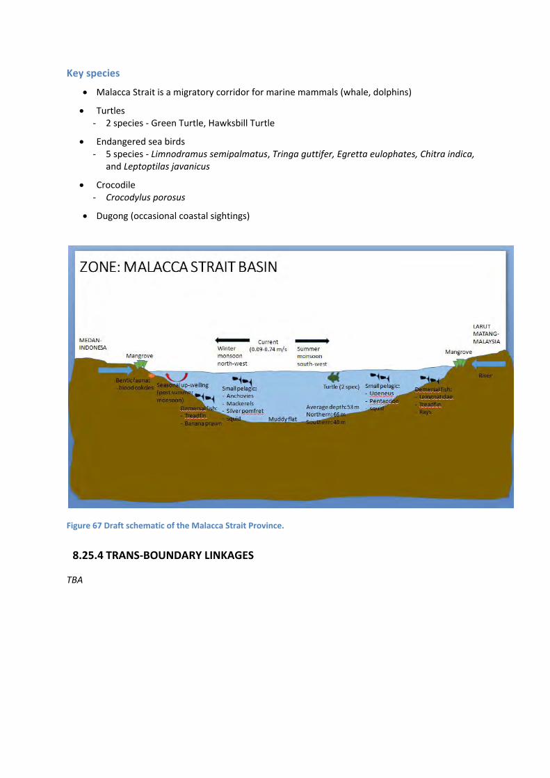
Key species
Malacca Strait is a migratory corridor for marine mammals (whale, dolphins)
Turtles ‐ 2 species ‐ Green Turtle, Hawksbill Turtle
Endangered sea birds ‐ 5 species ‐ Limnodramus semipalmatus, Tringa guttifer, Egretta eulophates, Chitra indica,
and Leptoptilas javanicus
Crocodile ‐ Crocodylus porosus
Dugong (occasional coastal sightings)
Figure 67 Draft schematic of the Malacca Strait Province.
8.25.4 TRANS‐BOUNDARY LINKAGES
TBA

8.26 Aceh ‐ Northern Sumatra Province
Banda Aceh border, North west Island of Sumatra to Weh Island, northwest of Sumatra.
8.26.1 PROVINCE BOUNDARIES
Narrow steep shelf allowing deep waters to interact with coastal waters
Confluence of surface waters from the Strait of Malacca and the Andaman Sea in the east
Confluence of surface waters from the Andaman Sea and the Andaman Ridge in the west
Narrow of shelf restricts scale and persistence of productivity events
8.26.2 BIOPHYSICAL DRIVERS
Figure 69 Map of Aceh ‐ Northern Sumatra geomorphology.
Geomorphological Feature
Bathymetry ‐ Very short distant shelf (steep slope) ‐ 200 m outer shelf depth
Weh Island ‐ Small active volcanic Island
Figure 68 Aceh ‐ Northern Sumatra Province

Climate
Prevailing south west and north west monsoon
Oceanography
Semi diurnal tide
Average sea surface temperature, 28‐30°C
Salinity 31‐32 ppm
Fresh water intrusion Easterly current flow
8.26.3 ECOLOGICAL ASSETS
Figure 70 Map of size (km2) of seagrass, mangrove and coral cover within the Aceh – Northern Sumatra Province.
Sources ‐ Coral (IMAS‐USF (2005), IMaRS‐USF (2005), Spalding et al. (2001), UNEP‐WCMC (2010)); Seagrass (UNEP‐WCMC, Short FT (2005), Green EP, Short FT (2003)); Mangroves (UNEP‐WCMC, Giri C, Ochieng E, Tieszen LL, Zhu Z, Singh A, Loveland T, Masek J, Duke N (2011a). Giri C, Ochieng E, Tieszen LL, Zhu Z, Singh A, Loveland T, Masek J, Duke N (2011b)).
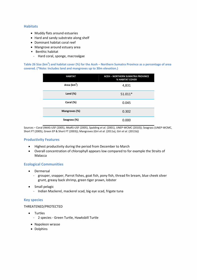
Habitats
Muddy flats around estuaries
Hard and sandy substrate along shelf Dominant habitat coral reef
Mangrove around estuary area • Benthic habitat ‐ Hard coral, sponge, macroalgae
Table 26 Size (km2) and habitat cover (%) for the Aceh – Northern Sumatra Province as a percentage of area covered. (*Note: Includes land and mangroves up to 30m elevation.)
HABITAT ACEH – NORTHERN SUMATRA PROVINCE % HABITAT COVER
Area (km2) 4,831
Land (%) 51.011*
Coral (%) 0.045
Mangroves (%) 0.302
Seagrass (%) 0.000
Sources – Coral (IMAS‐USF (2005), IMaRS‐USF (2005), Spalding et al. (2001), UNEP‐WCMC (2010)); Seagrass (UNEP‐WCMC, Short FT (2005), Green EP & Short FT (2003)); Mangroves (Giri et al. (2011a), Giri et al. (2011b))
Productivity Features
Highest productivity during the period from December to March
Overall concentration of chlorophyll appears low compared to for example the Straits of Malacca
Ecological Communities
Dermersal ‐ grouper, snapper, Parrot fishes, goat fish, pony fish, thread fin bream, blue cheek silver
grunt, greasy back shrimp, green tiger prawn, lobster
Small pelagic ‐ Indian Mackerel, mackerel scad, big eye scad, frigate tuna
Key species
THREATENED/PROTECTED
Turtles ‐ 2 species ‐ Green Turtle, Hawksbill Turtle
Napoleon wrasse Dolphins

Figure 71 Draft schematic of the Aceh ‐ Northern Sumatra Province
8.26.4 TRANS‐BOUNDARY LINKAGES
TBA
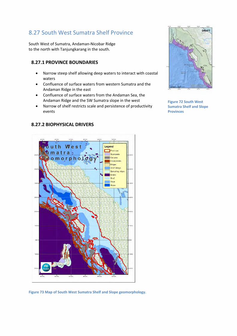
8.27 South West Sumatra Shelf Province
South West of Sumatra, Andaman‐Nicobar Ridge to the north with Tanjungkarang in the south.
8.27.1 PROVINCE BOUNDARIES
Narrow steep shelf allowing deep waters to interact with coastal waters
Confluence of surface waters from western Sumatra and the Andaman Ridge in the east
Confluence of surface waters from the Andaman Sea, the Andaman Ridge and the SW Sumatra slope in the west
Narrow of shelf restricts scale and persistence of productivity events
8.27.2 BIOPHYSICAL DRIVERS
Figure 73 Map of South West Sumatra Shelf and Slope geomorphology.
Figure 72 South West Sumatra Shelf and Slope Provinces

Geomorphological Feature
Island and deep channel ‐ trough in between Nias and Simeuleu Islands and mainland
Fragmented coastline
Climate
prevailing south west monsoon
Rainfalls in Simeuleu ‐ March – July 100‐150 mm ‐ Aug – Dec 150‐300 mm
Oceanography
Tsunami prone area ‐ Struck by tsunami in 2010
Current ‐ westerly direction ‐ split as moves between Nias and Simeuleu Island ‐ moves North Westerly, East coast Simeuleu island ‐ moves South Easterly, East coast Nias Island
Sea surface temperature ‐ Summer monsoon 29°C ‐ Winter monsoon 28°C
8.27.3 ECOLOGICAL ASSETS
Table 27 Size (km2) and habitat cover (%) for the South West Sumatra Shelf Province as a percentage of area covered. (*Note: Includes land and mangroves up to 30m elevation.)
HABITAT SOUTH WEST SUMATRA SHELF PROVINCE % HABITAT COVER
Area (km2) 143,641
Land (%) 15.255
Coral (%) 0.864
Mangroves (%) 0.179
Seagrass (%) 0.406
Sources – Coral (IMAS‐USF (2005), IMaRS‐USF (2005), Spalding et al. (2001), UNEP‐WCMC (2010)); Seagrass (UNEP‐WCMC, Short FT (2005), Green EP & Short FT (2003)); Mangroves (Giri et al. (2011a), Giri et al. (2011b))
Habitats
Coastal ‐ fringing coral reefs, coral reefs
Mangrove ‐ west coast and eastern part Simeuleu and Nias Island

Seagrass ‐ western part of Nias and Simeuleu Islands
Figure 74 Map of size (km2) of seagrass, mangrove and coral cover within the South West Sumatra Shelf and Slope Provinces
Sources ‐ Coral (IMAS‐USF (2005), IMaRS‐USF (2005), Spalding et al. (2001), UNEP‐WCMC (2010)); Seagrass (UNEP‐WCMC, Short FT (2005), Green EP, Short FT (2003)); Mangroves (UNEP‐WCMC, Giri C, Ochieng E, Tieszen LL, Zhu Z, Singh A, Loveland T, Masek J, Duke N (2011a). Giri C, Ochieng E, Tieszen LL, Zhu Z, Singh A, Loveland T, Masek J, Duke N (2011b)).
Productivity Features
Being a narrow shelf, there appears to be little productivity for much of the year
Seasonal upwelling ‐ western side of Nias island

Ecological Communities
Small pelagic ‐ Indian mackerel, Short bodied mackerel, Scad mackerel, Trevally, Anchovy
Large pelagic ‐ Yellow fin Tuna, Big eye Tuna and Skipjack, Ray
Demersal fishes ‐ Pony fish, Endeavour prawn, Lobster
Key species
THREATENED/PROTECTED
Turtles ‐ 3 species ‐ Green Turtle, Hawksbill Turtle, Leatherback Turtle
Sharks ‐ Charcarhinus sp
Giant clam, Tridacna gigas
Napolean wrasse, Chelinius undulates Marine mammals ‐ blue whales & dolphins
Blue‐spotted ray, Neotrygon kuhlii
Figure 75 Draft schematic of the South West Sumatra Shelf Province.
8.27.4 TRANS‐BOUNDARY LINKAGES
TBA

8.28 South West Sumatra Slope Province
South West of Sumatra, Andaman‐Nicobar Ridge to the north, extending into the Cocos Abyss, with Tanjungkarang in the south.
8.28.1 PROVINCE BOUNDARIES
As per South West Sumatra Shelf Province
Unusual contorted, fragmented with variable geomorphs
Diverse habitats appear to support diverse community types
Narrow shelf region enables slope waters to upwell close to shore
Deep species may also intermingle with shelf species
Offshore interaction with deep waters from the Cocos Basin
8.28.2 BIOPHYSICAL DRIVERS
Geomorphological Feature
Slope ‐ Steep ‐ West belt mostly mountainous
Climate
Prevailing South West monsoon
Cyclonic winds
Oceanography
Shallow thermocline (90 m) ‐ No offshore upwelling due to barrier layer
Offshore waters display low salinities due to heavy monsoonal rains and high (>28°C) sea surface temperature
8.28.3 ECOLOGICAL ASSETS
Habitats
Terrigenous sediment ‐ Silt, clay in deep water

Table 28 Size (km2) and habitat cover (%) for the South West Sumatra Slope Province as a percentage of area covered. (*Note: Includes land and mangroves up to 30m elevation.)
HABITAT SOUTH WEST SUMATRA SLOPE PROVINCE % HABITAT COVER
Area (km2) 27,703
Land (%) 0.122
Coral (%) 0.612
Mangroves (%) 0.006
Seagrass (%) 0.000
Sources – Coral (IMAS‐USF (2005), IMaRS‐USF (2005), Spalding et al. (2001), UNEP‐WCMC (2010)); Seagrass (UNEP‐WCMC, Short FT (2005), Green EP & Short FT (2003)); Mangroves (Giri et al. (2011a), Giri et al. (2011b))
Productivity Features
Seasonal monsoonal may influence coastal dynamics
Ecological Communities
Eels ‐ Leptocephali
Key species
TBA
8.28.4 TRANS‐BOUNDARY LINKAGES
TBA

8.29 Ninety East Ridge Province
Located at southern eastern part of the Bay of Bengal, extends southwards towards the Indian Ocean, head laying 9.5oN and 90o E. Heights vary between 1000 m ‐1500 m from the ocean basin.
8.29.1 PROVINCE BOUNDARIES
Northern segment of an extensive ocean ridge system separating the Bay of Bengal abyss from the Cocos Basin
Northern boundary meets up with the Andaman Ridge
Exchanges between the deep Cocos Basin waters and BoB abyss may take place through channels in the ridge system
Contains a diverse set of geomorphs and geological facies that may act as surrogates for endemic deep water communities
Ridge and shallower seafloors on the ridge may allow interaction between species and communities from differing depth ranges
8.29.2 BIOPHYSICAL DRIVERS
Geomorphological Feature
Slope 50%
Escarpment 38%
Basins 6.9%
Canyon 6.6%
Shallowest depth 2200 m
Deepest depth 3800 m
Climate
Monsoon
Oceanography
Area peculiar for bottom topography and unfavourable hydrometeorological conditions.
heavy currents
high winds
rough sea conditions
Figure 76 Ninety East Ridge Province

Figure 77 Map of Ninety East Ridge geomorphology.
8.29.3 ECOLOGICAL ASSETS
Habitats
Dark
Cold
Highly saline
Mud, ooze (possibly rock)

Table 29 Size (km2) and habitat cover (%) for the Ninety East Ridge Province as a percentage of area covered. (*Note: Includes land and mangroves up to 30m elevation.)
HABITAT NINETY EAST RIDGE PROVINCE % HABITAT COVER
Area (km2) 229,538
Land (%) 0.000
Coral (%) 0.000
Mangroves (%) 0.000
Seagrass (%) 0.000
Sources – Coral (IMAS‐USF (2005), IMaRS‐USF (2005), Spalding et al. (2001), UNEP‐WCMC (2010)); Seagrass (UNEP‐WCMC, Short FT (2005), Green EP & Short FT (2003)); Mangroves (Giri et al. (2011a), Giri et al. (2011b))
Productivity Features
High productive compare to the other deep areas of the region
Marine snow
Ecological Communities
TBA
Key species
Pelagic fish
‐ Yellowfin tuna (Thunnus albacores) ‐ Bigeye tuna (Thunnus obesus) ‐ Lancet fish (Alepisaurus ferox) ‐ Escolar (Lepidocybium flavobrunneum) ‐ Marine eels, smoothheads (Alepocephalidae) and grenadiers (Macrouridae)
Benthic fauna
‐ Polychaetes ‐ Crustaceans (isopods, shrimps, crabs) ‐ Crinoids ‐ Echinoids (brittle stars) ‐ Bivalves ‐ Jellyfish ‐ Gupel Eel ‐ Angler fish

Figure 78 Draft schematic of the Ninety east Ridge Province.
8.29.4 TRANS‐BOUNDARY LINKAGES
TBA

8.30 Cocos Abyss Province
Province bounded by the Ninety East ridge in the west, the Sunda Trench in the northeast, and delineated by isobath patterns in the south (Pushcharovsky 2007). Depth is typically between 5000m and 6000 m.
8.30.1 PROVINCE BOUNDARIES
Unique abyssal province flanked in the west by the Ninety East Ridge and in the east by Sumatra and the Andaman Ridge system
Andaman Ridge boundary restricts exchanges of deep ocean waters with the Bengal abyss
Nature of seafloor and deep waters likely to be influenced by geothermal processes, tectonic events and deep ocean circulation and mixing
Rain of productivity by‐products from monsoonal events; varies seasonally and regionally leading to seasonality in rain of material to deep ocean
May contains resources and regions of unique and rare deep ocean communities, particularly at the boundaries in the west, the east and the north – where a number of different provinces intersect
8.30.2 BIOPHYSICAL DRIVERS
Figure 80 Map of Cocos Abyss geomorphology.
Figure 79 Cocos Abyss Province

Geomorphological Feature
Most of this Province comprises dominantly flat abyssal plain occurring at water depths around 5,500 km.
The eastern boundary lies along a ridge of complex escarpments separating the abyssal habitat from the slope
Some seamounts in the south east corner and western edge of the Province
Climate
TBA
Oceanography
The deep ocean has constant salinity of about 35 ppt and temperatures close to 0oC
8.30.3 ECOLOGICAL ASSETS
Habitats
Dominated by fine, homogenous sediment throughout the basin seabed environment
Main habitat gradients are related to depth and the influence of depth on water temperature
Seamounts provide a courser sediment regime
The relatively abundant escarpment habitat is likely to have rock features with some pockets of courser or fine sediment
Table 30 Size (km2) and habitat cover (%) for the Cocos Abyss Province as a percentage of area covered. (*Note: Includes land and mangroves up to 30m elevation.)
HABITAT COCOS ABYSS PROVINCE % HABITAT COVER
Area (km2) 572,413
Land (%) 0.000
Coral (%) 0.000
Mangroves (%) 0.000
Seagrass (%) 0.000
Sources – Coral (IMAS‐USF (2005), IMaRS‐USF (2005), Spalding et al. (2001), UNEP‐WCMC (2010)); Seagrass (UNEP‐WCMC, Short FT (2005), Green EP & Short FT (2003)); Mangroves (Giri et al. (2011a), Giri et al. (2011b))
Productivity Features
Energy for ecological communities and species is mainly from particulate living and dead organic matter (‘marine snow’) that sinks from the surface environments. These are derived from a wide range of sources including dead animals and plants, sloughed exoskeletons, faecal material, dislodged scales and other body parts
Some whole carcasses of larger animals provide unique habitat for specific opportunistic species
Little evidence of productivity generated elsewhere being advected into this province

Ecological Communities
Flat abyssal plains communities are likely to be dominated by deposit feeders and marine bacteriophages
Some secondary and tertiary species will also occur, including bioluminescent species and those that use photophores
Escarpments and seamounts are likely to support attached epi‐benthic invertebrate communities and demersal species that use these then for shelter and food
Key species
TBA
8.30.4 TRANS‐BOUNDARY LINKAGES
TBA