Embed Size (px)
Citation preview

3,350+OPEN ACCESS BOOKS
108,000+INTERNATIONAL
AUTHORS AND EDITORS115+ MILLION
DOWNLOADS
BOOKSDELIVERED TO
151 COUNTRIES
AUTHORS AMONG
TOP 1%MOST CITED SCIENTIST
12.2%AUTHORS AND EDITORS
FROM TOP 500 UNIVERSITIES
Selection of our books indexed in theBook Citation Index in Web of Science™
Core Collection (BKCI)
Chapter from the book Tectonics - Recent AdvancesDownloaded from: http://www.intechopen.com/books/tectonics-recent-advances
PUBLISHED BY
World's largest Science,Technology & Medicine
Open Access book publisher
Interested in publishing with IntechOpen?Contact us at [email protected]
Chapter 7
© 2012 Kürçer et al., licensee InTech. This is an open access chapter distributed under the terms of the Creative Commons Attribution License (http://creativecommons.org/licenses/by/3.0), which permits unrestricted use, distribution, and reproduction in any medium, provided the original work is properly cited.
An Assessment of the Earthquakes of Ancient Troy, NW Anatolia, Turkey
Akın Kürçer, Alexandros Chatzipetros, Salih Zeki Tutkun, Spyros Pavlides, Süha Özden, George Syrides, Kostas Vouvalidis, Emin Ulugergerli, Özkan Ateş and Yunus Levent Ekinci
Additional information is available at the end of the chapter
http://dx.doi.org/10.5772/48471
1. Introduction
Many destructive earthquakes occurred in Northwestern Anatolia during historical and
instrumental periods and as a result of these earthquakes civilities were damaged.
Approximately 30 km southwest of Çanakkale the ancient city of Troy is located, containing
remains belonging to the period between B.C. 3000 and A.D. 400 (Figure 1).
According to the intermittent archeological excavations, carried out from 1871 up to the
present, there exist nine different layers of settlements in Troy. Although there is some
archeological evidence which indicates that some of these layers, especially Troy III (B.C.
2200‐2050) and Troy VI (B.C. 1800‐1275) have been damaged by one or more earthquakes, no
multidisciplinary geoscientific research has been carried out so far on the active faults which
could have caused these earthquakes.
Troy which once controlled the commercial crossing point between Asia and Europe over
Dardanos (the Dardanelles) used to be one of the most important trade centers of that era.
Because of this fact Troy, besides being one of the hundreds of ancient cities situated in
Anatolia, was a city that played an important role in the development of Western Anatolian
and Aegean cultures. As a result of Troy’s dominant position, several European countries
believe that their roots lie in Troy and Trojans. When the architecture of Troy, represented
by 9 layers of settlements spanning the period between B.C. 3000 and A.D. 400, is examined,
it is observed that passages between civilizations are not gradual; instead, there are radical
changes in building styles and materials. This observation can lead to the assumption that
the events causing passages between civilizations are natural phenomena such as earth‐
quakes rather than wars, fires or epidemics. On the other hand, Professor Manfred Korfman,
who meticulously presided over Troy excavations between 1968 and 2005, talks
Tectonics – Recent Advances
172
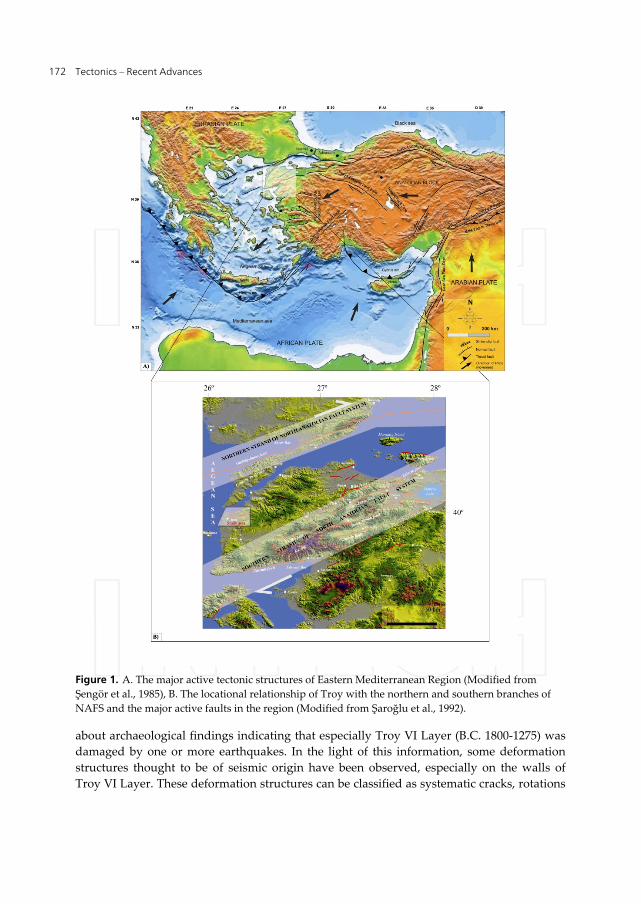
Figure 1. A. The major active tectonic structures of Eastern Mediterranean Region (Modified from
Şengör et al., 1985), B. The locational relationship of Troy with the northern and southern branches of
NAFS and the major active faults in the region (Modified from Şaroğlu et al., 1992).
about archaeological findings indicating that especially Troy VI Layer (B.C. 1800‐1275) was
damaged by one or more earthquakes. In the light of this information, some deformation
structures thought to be of seismic origin have been observed, especially on the walls of
Troy VI Layer. These deformation structures can be classified as systematic cracks, rotations
An Assessment of the Earthquakes of Ancient Troy, NW Anatolia, Turkey
173
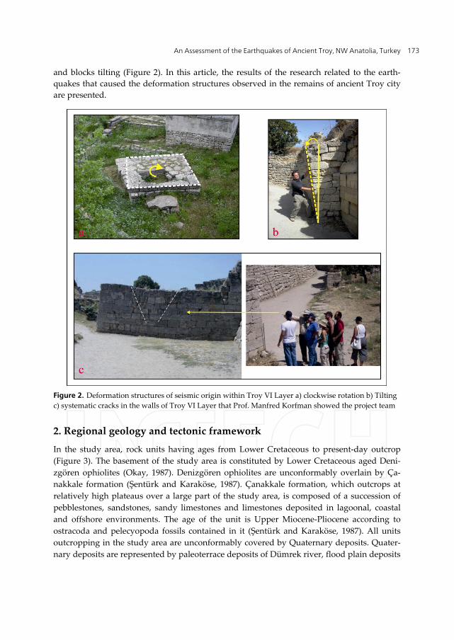
and blocks tilting (Figure 2). In this article, the results of the research related to the earth‐
quakes that caused the deformation structures observed in the remains of ancient Troy city
are presented.
Figure 2. Deformation structures of seismic origin within Troy VI Layer a) clockwise rotation b) Tilting
c) systematic cracks in the walls of Troy VI Layer that Prof. Manfred Korfman showed the project team
2. Regional geology and tectonic framework
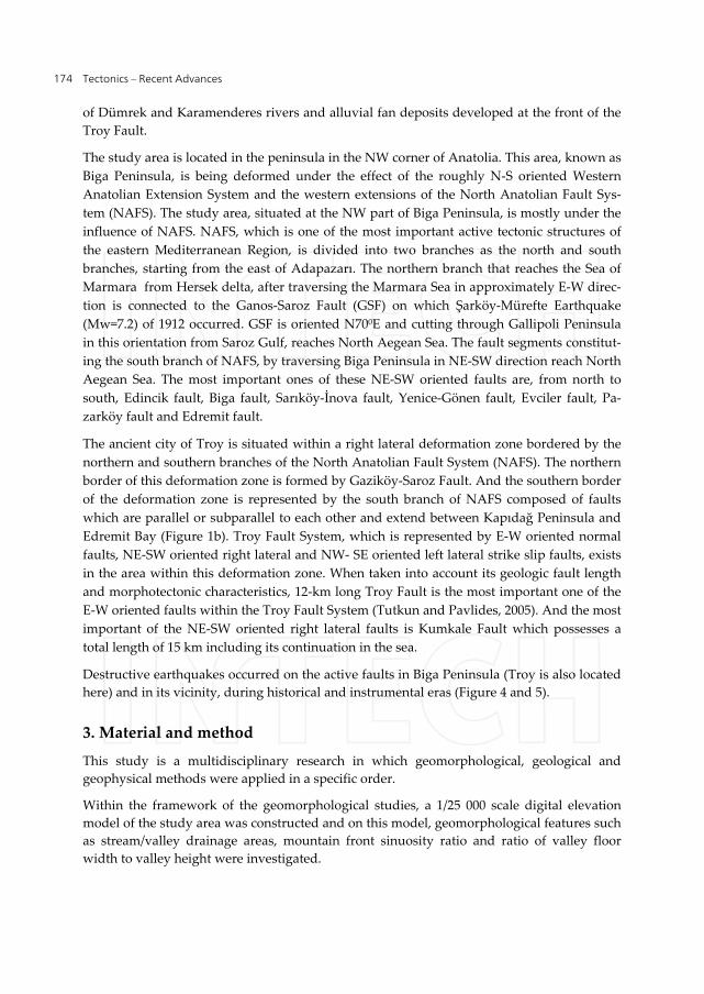
In the study area, rock units having ages from Lower Cretaceous to present‐day outcrop
(Figure 3). The basement of the study area is constituted by Lower Cretaceous aged Deni‐
zgören ophiolites (Okay, 1987). Denizgören ophiolites are unconformably overlain by Ça‐
nakkale formation (Şentürk and Karaköse, 1987). Çanakkale formation, which outcrops at
relatively high plateaus over a large part of the study area, is composed of a succession of
pebblestones, sandstones, sandy limestones and limestones deposited in lagoonal, coastal
and offshore environments. The age of the unit is Upper Miocene‐Pliocene according to
ostracoda and pelecyopoda fossils contained in it (Şentürk and Karaköse, 1987). All units
outcropping in the study area are unconformably covered by Quaternary deposits. Quater‐
nary deposits are represented by paleoterrace deposits of Dümrek river, flood plain deposits
Tectonics – Recent Advances
174
of Dümrek and Karamenderes rivers and alluvial fan deposits developed at the front of the Troy Fault.
The study area is located in the peninsula in the NW corner of Anatolia. This area, known as
Biga Peninsula, is being deformed under the effect of the roughly N‐S oriented Western
Anatolian Extension System and the western extensions of the North Anatolian Fault Sys‐
tem (NAFS). The study area, situated at the NW part of Biga Peninsula, is mostly under the
influence of NAFS. NAFS, which is one of the most important active tectonic structures of
the eastern Mediterranean Region, is divided into two branches as the north and south
branches, starting from the east of Adapazarı. The northern branch that reaches the Sea of
Marmara from Hersek delta, after traversing the Marmara Sea in approximately E‐W direc‐
tion is connected to the Ganos‐Saroz Fault (GSF) on which Şarköy‐Mürefte Earthquake
(Mw=7.2) of 1912 occurred. GSF is oriented N700E and cutting through Gallipoli Peninsula
in this orientation from Saroz Gulf, reaches North Aegean Sea. The fault segments constitut‐
ing the south branch of NAFS, by traversing Biga Peninsula in NE‐SW direction reach North
Aegean Sea. The most important ones of these NE‐SW oriented faults are, from north to
south, Edincik fault, Biga fault, Sarıköy‐İnova fault, Yenice‐Gönen fault, Evciler fault, Pa‐
zarköy fault and Edremit fault.
The ancient city of Troy is situated within a right lateral deformation zone bordered by the
northern and southern branches of the North Anatolian Fault System (NAFS). The northern
border of this deformation zone is formed by Gaziköy‐Saroz Fault. And the southern border
of the deformation zone is represented by the south branch of NAFS composed of faults
which are parallel or subparallel to each other and extend between Kapıdağ Peninsula and
Edremit Bay (Figure 1b). Troy Fault System, which is represented by E‐W oriented normal
faults, NE‐SW oriented right lateral and NW‐ SE oriented left lateral strike slip faults, exists
in the area within this deformation zone. When taken into account its geologic fault length
and morphotectonic characteristics, 12‐km long Troy Fault is the most important one of the
E‐W oriented faults within the Troy Fault System (Tutkun and Pavlides, 2005). And the most
important of the NE‐SW oriented right lateral faults is Kumkale Fault which possesses a
total length of 15 km including its continuation in the sea.
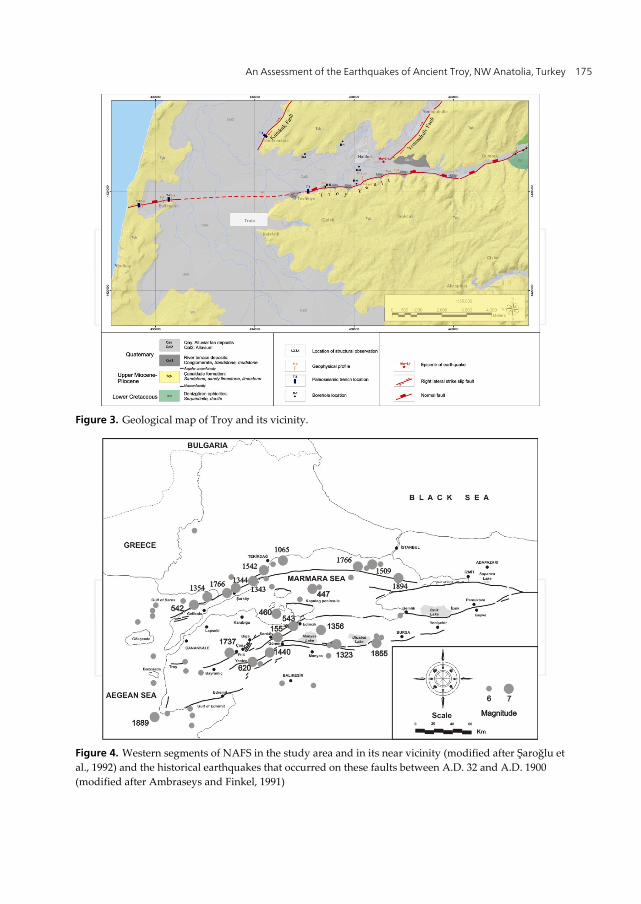
Destructive earthquakes occurred on the active faults in Biga Peninsula (Troy is also located
here) and in its vicinity, during historical and instrumental eras (Figure 4 and 5).
3. Material and method
This study is a multidisciplinary research in which geomorphological, geological and
geophysical methods were applied in a specific order.
Within the framework of the geomorphological studies, a 1/25 000 scale digital elevation
model of the study area was constructed and on this model, geomorphological features such
as stream/valley drainage areas, mountain front sinuosity ratio and ratio of valley floor
width to valley height were investigated.
An Assessment of the Earthquakes of Ancient Troy, NW Anatolia, Turkey
175
Figure 3. Geological map of Troy and its vicinity.
Figure 4. Western segments of NAFS in the study area and in its near vicinity (modified after Şaroğlu et
al., 1992) and the historical earthquakes that occurred on these faults between A.D. 32 and A.D. 1900
(modified after Ambraseys and Finkel, 1991)
Tectonics – Recent Advances
176
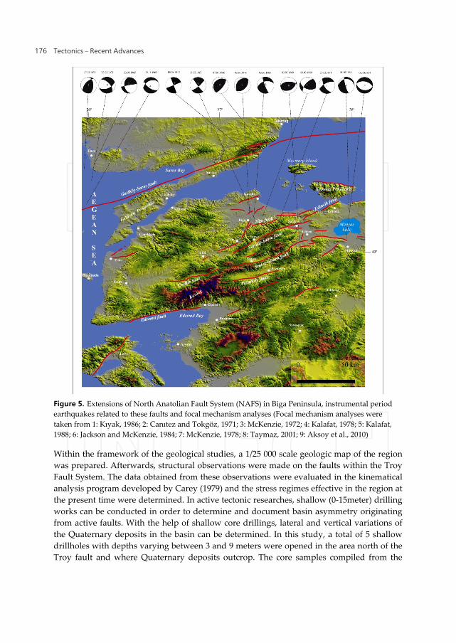
Figure 5. Extensions of North Anatolian Fault System (NAFS) in Biga Peninsula, instrumental period
earthquakes related to these faults and focal mechanism analyses (Focal mechanism analyses were
taken from 1: Kıyak, 1986; 2: Canıtez and Tokgöz, 1971; 3: McKenzie, 1972; 4: Kalafat, 1978; 5: Kalafat,
1988; 6: Jackson and McKenzie, 1984; 7: McKenzie, 1978; 8: Taymaz, 2001; 9: Aksoy et al., 2010)
Within the framework of the geological studies, a 1/25 000 scale geologic map of the region
was prepared. Afterwards, structural observations were made on the faults within the Troy
Fault System. The data obtained from these observations were evaluated in the kinematical
analysis program developed by Carey (1979) and the stress regimes effective in the region at
the present time were determined. In active tectonic researches, shallow (0‐15meter) drilling
works can be conducted in order to determine and document basin asymmetry originating
from active faults. With the help of shallow core drillings, lateral and vertical variations of
the Quaternary deposits in the basin can be determined. In this study, a total of 5 shallow
drillholes with depths varying between 3 and 9 meters were opened in the area north of the
Troy fault and where Quaternary deposits outcrop. The core samples compiled from the
An Assessment of the Earthquakes of Ancient Troy, NW Anatolia, Turkey
177
drillings were logged and interpreted. In this study, along the Troy fault, using Direct
Current Resistivity method measurements were made along 8 profiles with an average
length of 200 meters and perpendicular to the fault. And applying two‐dimensional inverse
solution, geoelectric cross‐ sections for the shallow depths (0‐15 meters) of the earth were
obtained. And lastly, in the study paleoseismological trench works were conducted in the
areas determined according to geological observations and geophysical data. Within the
scope of this work, a total of 4 trench works were carried out, 3 trenches on Troy fault and 1
on Kumkale fault. All of the trenches were excavated perpendicular to the fault, with an
average length of 10‐15 meters, 3‐4m wide and 4‐6m deep. A total of 20 carbon‐containing
soil samples were compiled from the trenches for C‐14 dating. These samples were analyzed
at Beta Analytical Laboratory in the United States of America.
4. Findings
4.1. Morphotectonic analysis of Troy Fault
The geomorphology of a region can be described based on specific measurements of its
morphological characteristics. This method, defined as morphometry, is realized by digitally
deriving information about geomorphological elements from the elevation values (DEM ‐
Digital Elevation Model) belonging to the region and analyzing them. These values,
obtained with the help of morphometry, can provide consistent and fast information both
on the evolution of the drainage in the study area and on the degree, distribution and
character of the structural/lithological control on this evolution (Keller and Pinter, 1996).
For this purpose, through the digitization of the 1/25 000 scale sheets of Ayvalık I 16 a2 and
Ayvalık I 16 b1 belonging to the study area, the digital elevation model of the region was
created (Figure 6). The geomorphological characteristics of the region were investigated on
this model. The geologic map of the region was draped over the digital elevation model as a
separate layer and a relief geologic map was obtained (Figure 3).
The purpose of the morphotectonic analysis is to digitally reveal the degree of influence of
the erosional and tectonic processes effective in the morphological shaping of a region. In
this study, such geomorphological indices as mountain front sinuosity ratio (Smf index),
stream/valley drainage areas and profiles, and valley floor width to valley height ratio (Vf
index) were calculated.
Mountain front sinuosity ratio (Smf) is an index that reflects the balance between erosional forces
that tend to cut embayments into a mountain front and the tectonic forces that tend to produce a
straight mountain front. Mountain fronts uplifted by active tectonism are straight and have low
Smf values. And mountain fronts that move slowly or have lost their activity display irregular
forms and high values because they are destroyed by erosional forces (for further information,
see Keller and Pinter, 1996). If Smf values are between 1 and 2, the fault in question has high
activity. If this value is greater than 2, the activity of the fault should be considered as doubtful.
However, one must bear in mind that Smf index can also be affected by the strength properties of
the rocks forming the mounting front involved in faulting and by erosional activities.
Tectonics – Recent Advances
178
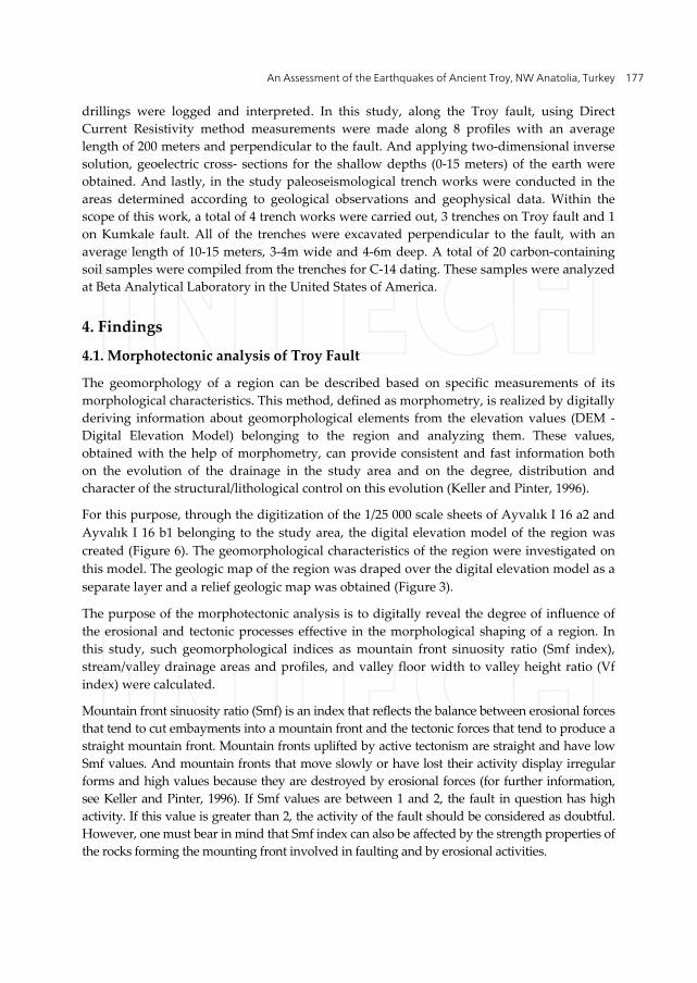
In the evaluation made by taking into account mountain front sinuosity ratios, Troy Fault is
subdivided into three geometric segments (Figure 6). These are, from east to west, Dümrek,
Halileli and Tevfikiye segments, respectively. According to their mountain front sinuosity
ratios, Tevfikiye and Halileli segments in the west have similar properties and are more
active (Smf=1.15 and 1.48, respectively), while Dümrek segment in the east has relatively
lower activity (Smf=2.52).
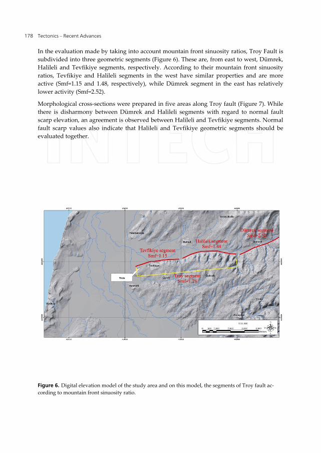
Morphological cross‐sections were prepared in five areas along Troy fault (Figure 7). While
there is disharmony between Dümrek and Halileli segments with regard to normal fault
scarp elevation, an agreement is observed between Halileli and Tevfikiye segments. Normal
fault scarp values also indicate that Halileli and Tevfikiye geometric segments should be
evaluated together.
Figure 6. Digital elevation model of the study area and on this model, the segments of Troy fault ac‐
cording to mountain front sinuosity ratio.
An Assessment of the Earthquakes of Ancient Troy, NW Anatolia, Turkey
179
Figure 7. Locations of cross‐sections along Troy fault
When the ratio of valley floor width to valley height (Vf) is calculated, the parameters in the
formula are calculated at a certain distance from the mountain front for each valley. Higher
Vf values show lower uplift speed and lower Vf values indicates actively uplifted areas.
Vf values showed that Tevfikiye and Halileli segments show similar properties and are
more active; on the other hand, Dümrek segment has higher Vf values and hence is less
active.
As a result of the morphotectonic analysis studies, since Tevfikiye and Halileli segments
display similar morphotectonic characteristics, they were evaluated together and named the
Troy segment. Since Troy segment is more active compared to Dümrek segment, the
shallow geophysical and paleoseismological investigations related to the Troy fault were
mostly conducted on this segment.
Tectonics – Recent Advances
180
On the other hand, the expected maximum earthquake magnitude for Troy fault was
calculated using the empirical equations proposed by Pavlides and Caputo (2004). The total
length of the Troy fault is about 11‐12km, hence, the expected maximum earthquake
magnitude for the Troy fault was computed from the formula
Ms= 0.9‐log (SRL) + 5.48 (Pavlides and Caputo, 2004)
as Ms= 6.2‐6.5
4.2. Kinematic analysis studies along the Troy fault
Troy fault system, located within the right lateral deformation zone between the northern
and southern branches of NAFS, is represented by approximately E‐W oriented normal
faults, NE‐SW oriented right lateral and NW‐ SE oriented left lateral strike slip faults. When
taken into account its geologic fault length and morphotectonic characteristics, the Troy
fault is the most important one of the approximately E‐W oriented normal faults within the
Troy Fault System.
Troy fault was defined for the first time by Tutkun and Pavlides (2005). It is a normal fault
which is 11‐12 km long, approximately E‐W oriented, dipping 600 to the north (see Figure 3).
Troy fault has highly pronounced normal fault morphology and is composed of two seg‐
ments: Troy and Dümrek segments (See Figure 6).The Troy fault cuts Lower Cretaceous
aged Denizgören ophiolites in the NE parts of the study area. To the east of Dümrek village,
the fault makes a bend towards the west and continues in E‐W direction, and it brings Neo‐
gene aged Çanakkale Formation and Quaternary deposits face to face in this area (Kürçer et
al., 2006).
The fault enters the alluviums of Karamenderes Stream starting from the area where ancient
Troy settlement is located, but its continuation from here towards the west is not clear.
However, when its direction is followed, it can be seen that the fault trace again becomes
evident between Ballıburun and Kesiktepe (See Figure 3). That’s why, the sector of the Troy
fault between ancient Troy settlement and Ballıburun was interpreted as probable active
fault. In the drilling works we conducted in the Quaternary sediments in the hanging wall
of the Troy fault, the top of the Çanakkale Formation was cut at 7‐8 meter depth in the drill‐
ings B‐4 and B‐5 (See Figure 3) just north of the Troy fault. In the morphological cross‐
section (See Profile B in Figure 7) taken from an area between B‐4 and B‐5 drill locations, a
normal dip slip of about 50 meter was measured. When the top of Çanakkale formation is
taken as reference plane, cumulative dip slip in the Troy fault is around 60 meters including
7‐8 meters obtained from the drillings.
In the study area, apart from the Troy fault, strike slip reverse and normal faults are
observed, as well. In this context, within the Troy fault system, from 4 sites (for site
locations, see Figure 3, Table 1) where outcrop conditions permit, a total of 67 fault planes
were measured and calculated using numerical analysis method (Table 2). Site 1 was
measured in Neogene aged Çanakkale formation. Thanks to this site, the kinematic
condition of the final tectonic regime in the Troy region was determined.
An Assessment of the Earthquakes of Ancient Troy, NW Anatolia, Turkey
181
Site Longitude (N) Latitude (E) Age Lithology
1 35 s 0435107 4423466 Neogene Sandstone
2 35 s 0446204 4426875 Lower Cretaceous Serpantinite
3 35 s 0446695 4427003 Lower Cretaceous Serpantinite
4 35 s 0445035 4426292 Lower Cretaceous Serpantinite
Table 1. Coordinates of the sites where fault planes or fault assemblages outcropping in the vicinity of
Troy were measured; lithology and age of the measured geological units.
Site
N
σ1 Az / dip
σ2 Az / dip
σ 3 Az /dip R M.D.
S. D.
1 11 80 / 26 256 / 64 349 / 1 0.29 9.4 13.1
2 27 127 / 59 287 / 29 22 / 9 0.25 7.7 12.0
3 11 279 / 18 100 / 72 9 / 0 0.43 10.4 9.4
4 18 85 / 11 213 / 73 352 / 13 0.69 8.9 11.0
S1= 285 22° / 4° S3 = 15 21° / 6° Rm= 0.37
Table 2. The conditions of the principal stress axes [(σ1), (σ2), (σ3)] computed as a result of the evalua‐
tion of fault assemblages measured in the vicinity of Troy using Carey (1979) numerical analysis meth‐
od; R ratio, number of measurements (N), fault measurement sites, mean (M.D.) and standard deviation
(S.D.) values
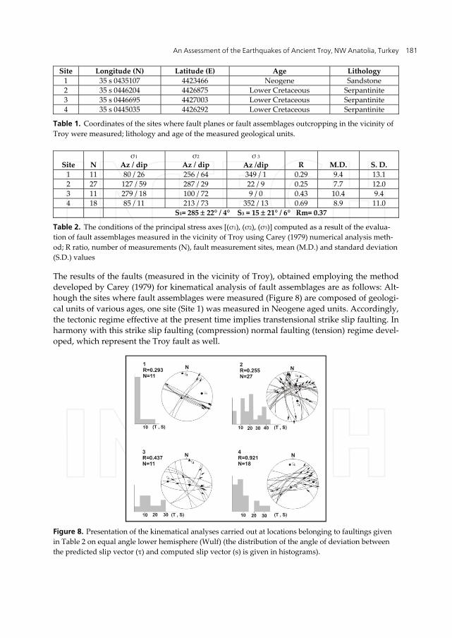
The results of the faults (measured in the vicinity of Troy), obtained employing the method
developed by Carey (1979) for kinematical analysis of fault assemblages are as follows: Alt‐
hough the sites where fault assemblages were measured (Figure 8) are composed of geologi‐
cal units of various ages, one site (Site 1) was measured in Neogene aged units. Accordingly,
the tectonic regime effective at the present time implies transtensional strike slip faulting. In
harmony with this strike slip faulting (compression) normal faulting (tension) regime devel‐
oped, which represent the Troy fault as well.
Figure 8. Presentation of the kinematical analyses carried out at locations belonging to faultings given
in Table 2 on equal angle lower hemisphere (Wulf) (the distribution of the angle of deviation between
the predicted slip vector (τ) and computed slip vector (s) is given in histograms).
Tectonics – Recent Advances
182
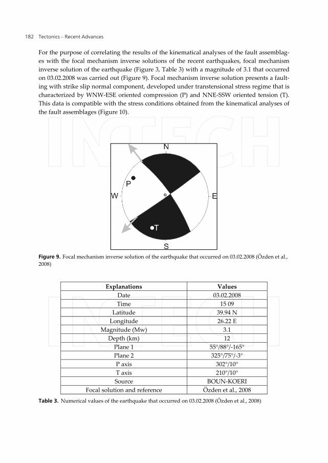
For the purpose of correlating the results of the kinematical analyses of the fault assemblag‐
es with the focal mechanism inverse solutions of the recent earthquakes, focal mechanism
inverse solution of the earthquake (Figure 3, Table 3) with a magnitude of 3.1 that occurred
on 03.02.2008 was carried out (Figure 9). Focal mechanism inverse solution presents a fault‐
ing with strike slip normal component, developed under transtensional stress regime that is
characterized by WNW‐ESE oriented compression (P) and NNE‐SSW oriented tension (T).
This data is compatible with the stress conditions obtained from the kinematical analyses of
the fault assemblages (Figure 10).
Figure 9. Focal mechanism inverse solution of the earthquake that occurred on 03.02.2008 (Özden et al.,
2008)
Explanations Values
Date 03.02.2008
Time 15 09
Latitude 39.94 N
Longitude 26.22 E
Magnitude (Mw) 3.1
Depth (km) 12
Plane 1 55°/88°/‐165°
Plane 2 325°/75°/‐3°
P axis 302°/10°
T axis 210°/10°
Source BOUN‐KOERI
Focal solution and reference Özden et al., 2008
Table 3. Numerical values of the earthquake that occurred on 03.02.2008 (Özden et al., 2008)

An Assessment of the Earthquakes of Ancient Troy, NW Anatolia, Turkey
183
Figure 10. Comparative presentation of the regional stress conditions obtained from the kinematical
analyses of the fault assemblages outcropping in the vicinity of Troy and the earthquake (black arrows
represent effective regimes and blue ones represent non‐effective regimes)
As a result; the Troy Fault System and stress regimes effective at the present time in the Troy
region show that a NNW‐SSE trending comppression and a NNE‐SSW oriented tension is
effective in this region and as a result of it, strike slip and normal faults developed under
transtensional tectonic regime.
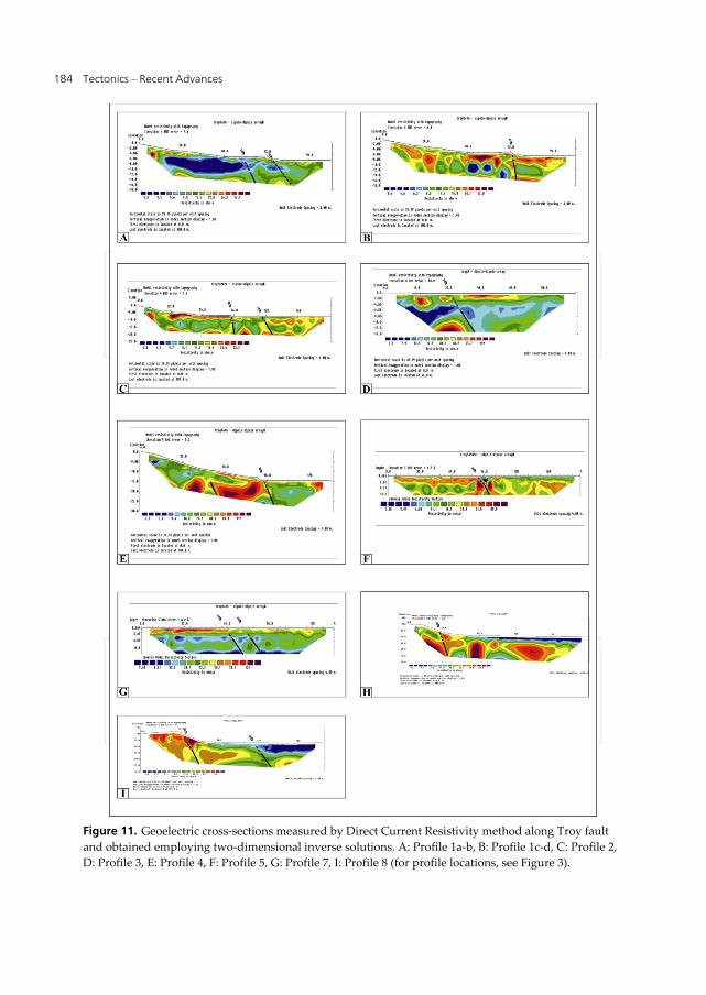
4.3. Shallow geophysical surveys along the Troy fault
Structural geology studies conducted along Troy fault aroused the suspicion that the fault
scarp might have been degraded in the course of time. In order to determine the fault trace
within Quaternary sediments, shallow geophysical researches employing direct current
resistivity method were carried out. Within this context, shallow depths (0‐20m) were inves‐
tigated along a total of 8 profiles determined perpendicular to the fault trace along the Troy
fault (for profile locations, see Figure 3). Two‐dimensional inverse solutions of the obtained
profiles were made and geoelectric cross‐sections were constructed (Figure 11). According
to the geoelectric cross‐sections obtained by means of shallow geophysical studies, some
discontinuities were encountered (Figure 11).
According to the Direct Current Resistivity studies conducted on the profiles perpendicular
to the fault trace along Troy fault, it passes 30‐100 meters north of morphologic escarpment
bordering the Troy rise. This condition can be explained by the degradation of the Troy fault
scarp in the course of time.
Tectonics – Recent Advances
184
Figure 11. Geoelectric cross‐sections measured by Direct Current Resistivity method along Troy fault
and obtained employing two‐dimensional inverse solutions. A: Profile 1a‐b, B: Profile 1c‐d, C: Profile 2,
D: Profile 3, E: Profile 4, F: Profile 5, G: Profile 7, I: Profile 8 (for profile locations, see Figure 3).
An Assessment of the Earthquakes of Ancient Troy, NW Anatolia, Turkey
185
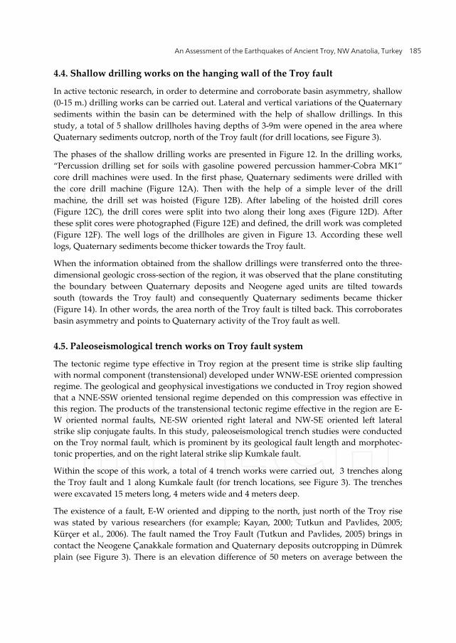
4.4. Shallow drilling works on the hanging wall of the Troy fault
In active tectonic research, in order to determine and corroborate basin asymmetry, shallow
(0‐15 m.) drilling works can be carried out. Lateral and vertical variations of the Quaternary
sediments within the basin can be determined with the help of shallow drillings. In this
study, a total of 5 shallow drillholes having depths of 3‐9m were opened in the area where
Quaternary sediments outcrop, north of the Troy fault (for drill locations, see Figure 3).
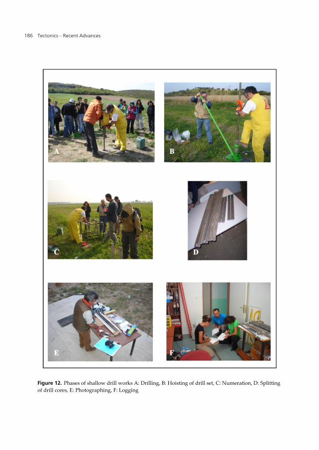
The phases of the shallow drilling works are presented in Figure 12. In the drilling works,
“Percussion drilling set for soils with gasoline powered percussion hammer‐Cobra MK1”
core drill machines were used. In the first phase, Quaternary sediments were drilled with
the core drill machine (Figure 12A). Then with the help of a simple lever of the drill
machine, the drill set was hoisted (Figure 12B). After labeling of the hoisted drill cores
(Figure 12C), the drill cores were split into two along their long axes (Figure 12D). After
these split cores were photographed (Figure 12E) and defined, the drill work was completed
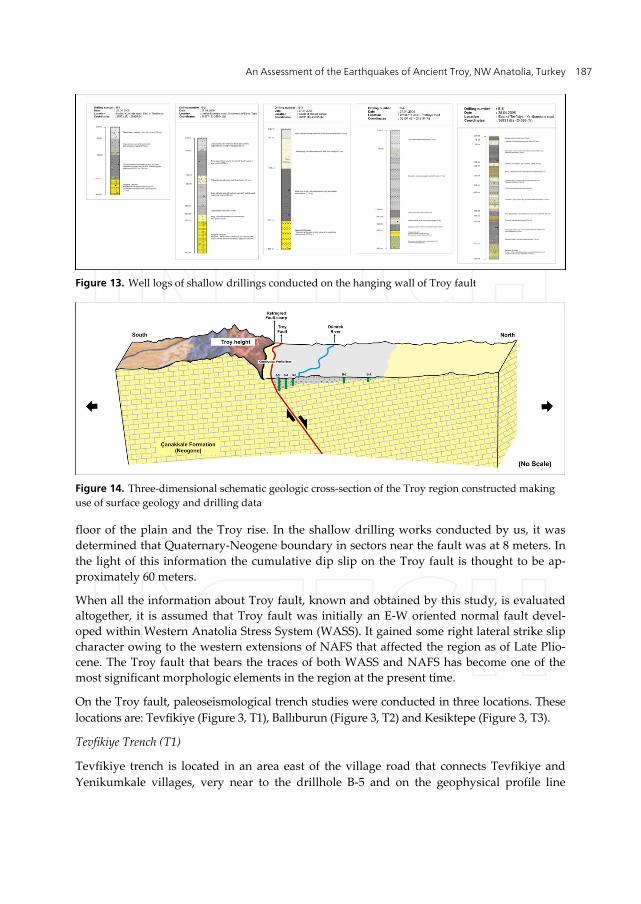
(Figure 12F). The well logs of the drillholes are given in Figure 13. According these well
logs, Quaternary sediments become thicker towards the Troy fault.
When the information obtained from the shallow drillings were transferred onto the three‐
dimensional geologic cross‐section of the region, it was observed that the plane constituting
the boundary between Quaternary deposits and Neogene aged units are tilted towards
south (towards the Troy fault) and consequently Quaternary sediments became thicker
(Figure 14). In other words, the area north of the Troy fault is tilted back. This corroborates
basin asymmetry and points to Quaternary activity of the Troy fault as well.
4.5. Paleoseismological trench works on Troy fault system
The tectonic regime type effective in Troy region at the present time is strike slip faulting
with normal component (transtensional) developed under WNW‐ESE oriented compression
regime. The geological and geophysical investigations we conducted in Troy region showed
that a NNE‐SSW oriented tensional regime depended on this compression was effective in
this region. The products of the transtensional tectonic regime effective in the region are E‐
W oriented normal faults, NE‐SW oriented right lateral and NW‐SE oriented left lateral
strike slip conjugate faults. In this study, paleoseismological trench studies were conducted
on the Troy normal fault, which is prominent by its geological fault length and morphotec‐
tonic properties, and on the right lateral strike slip Kumkale fault.
Within the scope of this work, a total of 4 trench works were carried out, 3 trenches along
the Troy fault and 1 along Kumkale fault (for trench locations, see Figure 3). The trenches
were excavated 15 meters long, 4 meters wide and 4 meters deep.
The existence of a fault, E‐W oriented and dipping to the north, just north of the Troy rise
was stated by various researchers (for example; Kayan, 2000; Tutkun and Pavlides, 2005;
Kürçer et al., 2006). The fault named the Troy Fault (Tutkun and Pavlides, 2005) brings in
contact the Neogene Çanakkale formation and Quaternary deposits outcropping in Dümrek
plain (see Figure 3). There is an elevation difference of 50 meters on average between the
Tectonics – Recent Advances
186
Figure 12. Phases of shallow drill works A: Drilling, B: Hoisting of drill set, C: Numeration, D: Splitting
of drill cores, E: Photographing, F: Logging
An Assessment of the Earthquakes of Ancient Troy, NW Anatolia, Turkey
187
Figure 13. Well logs of shallow drillings conducted on the hanging wall of Troy fault
Figure 14. Three‐dimensional schematic geologic cross‐section of the Troy region constructed making
use of surface geology and drilling data
floor of the plain and the Troy rise. In the shallow drilling works conducted by us, it was
determined that Quaternary‐Neogene boundary in sectors near the fault was at 8 meters. In
the light of this information the cumulative dip slip on the Troy fault is thought to be ap‐
proximately 60 meters.
When all the information about Troy fault, known and obtained by this study, is evaluated
altogether, it is assumed that Troy fault was initially an E‐W oriented normal fault devel‐
oped within Western Anatolia Stress System (WASS). It gained some right lateral strike slip
character owing to the western extensions of NAFS that affected the region as of Late Plio‐
cene. The Troy fault that bears the traces of both WASS and NAFS has become one of the
most significant morphologic elements in the region at the present time.
On the Troy fault, paleoseismological trench studies were conducted in three locations. These
locations are: Tevfikiye (Figure 3, T1), Ballıburun (Figure 3, T2) and Kesiktepe (Figure 3, T3).
Tevfikiye Trench (T1)
Tevfikiye trench is located in an area east of the village road that connects Tevfikiye and
Yenikumkale villages, very near to the drillhole B‐5 and on the geophysical profile line
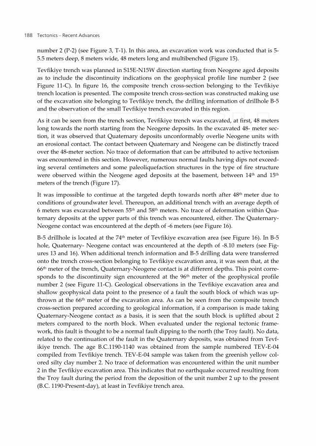
Tectonics – Recent Advances
188
number 2 (P‐2) (see Figure 3, T‐1). In this area, an excavation work was conducted that is 5‐
5.5 meters deep, 8 meters wide, 48 meters long and multibenched (Figure 15).
Tevfikiye trench was planned in S15E‐N15W direction starting from Neogene aged deposits
as to include the discontinuity indications on the geophysical profile line number 2 (see
Figure 11‐C). In figure 16, the composite trench cross‐section belonging to the Tevfikiye
trench location is presented. The composite trench cross‐section was constructed making use
of the excavation site belonging to Tevfikiye trench, the drilling information of drillhole B‐5
and the observation of the small Tevfikiye trench excavated in this region.
As it can be seen from the trench section, Tevfikiye trench was excavated, at first, 48 meters
long towards the north starting from the Neogene deposits. In the excavated 48‐ meter sec‐
tion, it was observed that Quaternary deposits unconformably overlie Neogene units with
an erosional contact. The contact between Quaternary and Neogene can be distinctly traced
over the 48‐meter section. No trace of deformation that can be attributed to active tectonism
was encountered in this section. However, numerous normal faults having dips not exceed‐
ing several centimeters and some paleoliquefaction structures in the type of fire structure
were observed within the Neogene aged deposits at the basement, between 14th and 15th
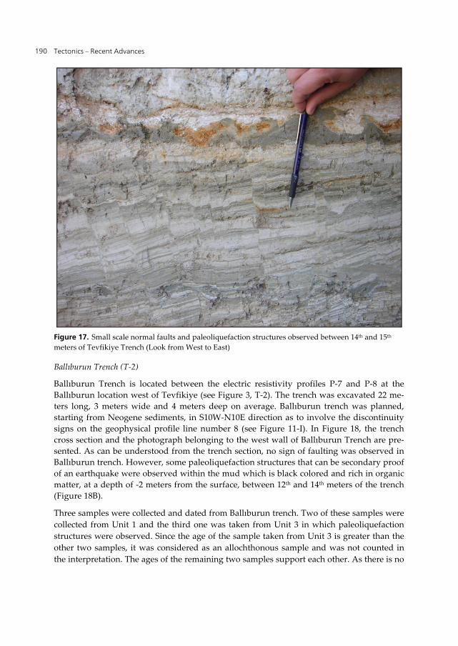
meters of the trench (Figure 17).
It was impossible to continue at the targeted depth towards north after 48th meter due to
conditions of groundwater level. Thereupon, an additional trench with an average depth of
6 meters was excavated between 55th and 58th meters. No trace of deformation within Qua‐
ternary deposits at the upper parts of this trench was encountered, either. The Quaternary‐
Neogene contact was encountered at the depth of ‐6 meters (see Figure 16).
B‐5 drillhole is located at the 74th meter of Tevfikiye excavation area (see Figure 16). In B‐5
hole, Quaternary‐ Neogene contact was encountered at the depth of ‐8.10 meters (see Fig‐
ures 13 and 16). When additional trench information and B‐5 drilling data were transferred
onto the trench cross‐section belonging to Tevfikiye excavation area, it was seen that, at the
66th meter of the trench, Quaternary‐Neogene contact is at different depths. This point corre‐
sponds to the discontinuity sign encountered at the 96th meter of the geophysical profile
number 2 (see Figure 11‐C). Geological observations in the Tevfikiye excavation area and
shallow geophysical data point to the presence of a fault the south block of which was up‐
thrown at the 66th meter of the excavation area. As can be seen from the composite trench
cross‐section prepared according to geological information, if a comparison is made taking
Quaternary‐Neogene contact as a basis, it is seen that the south block is uplifted about 2
meters compared to the north block. When evaluated under the regional tectonic frame‐
work, this fault is thought to be a normal fault dipping to the north (the Troy fault). No data,
related to the continuation of the fault in the Quaternary deposits, was obtained from Tevf‐
ikiye trench. The age B.C.1190‐1140 was obtained from the sample numbered TEV‐E‐04
compiled from Tevfikiye trench. TEV‐E‐04 sample was taken from the greenish yellow col‐
ored silty clay number 2. No trace of deformation was encountered within the unit number
2 in the Tevfikiye excavation area. This indicates that no earthquake occurred resulting from
the Troy fault during the period from the deposition of the unit number 2 up to the present
(B.C. 1190‐Present‐day), at least in Tevfikiye trench area.
An Assessment of the Earthquakes of Ancient Troy, NW Anatolia, Turkey
189
Figure 15. Look at Tevfikiye Trench from the North
Figure 16. Composite section of the East Wall of Tevfikiye Trench (T1)
Tectonics – Recent Advances
190
Figure 17. Small scale normal faults and paleoliquefaction structures observed between 14th and 15th
meters of Tevfikiye Trench (Look from West to East)
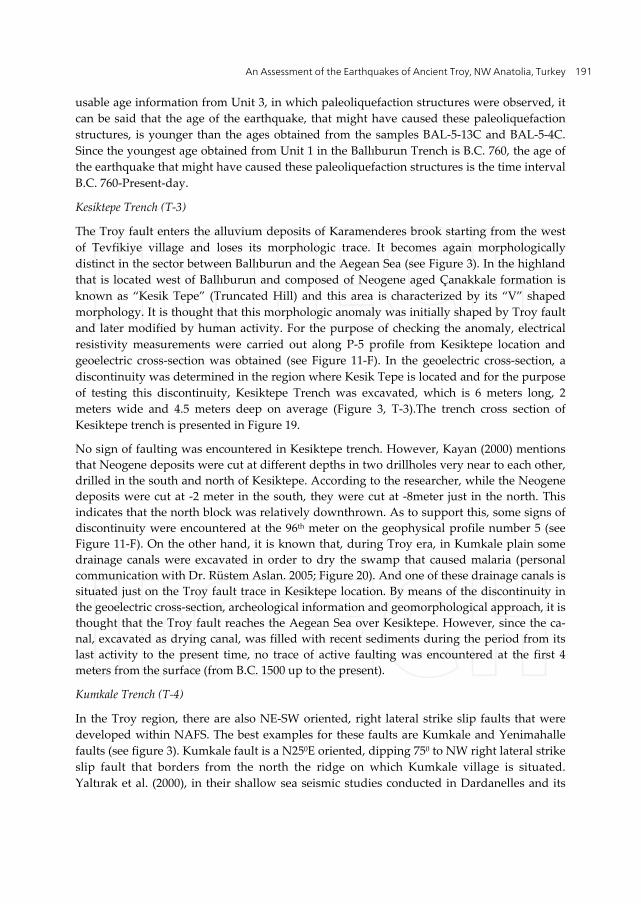
Ballıburun Trench (T‐2)
Ballıburun Trench is located between the electric resistivity profiles P‐7 and P‐8 at the
Ballıburun location west of Tevfikiye (see Figure 3, T‐2). The trench was excavated 22 me‐
ters long, 3 meters wide and 4 meters deep on average. Ballıburun trench was planned,
starting from Neogene sediments, in S10W‐N10E direction as to involve the discontinuity
signs on the geophysical profile line number 8 (see Figure 11‐I). In Figure 18, the trench
cross section and the photograph belonging to the west wall of Ballıburun Trench are pre‐
sented. As can be understood from the trench section, no sign of faulting was observed in
Ballıburun trench. However, some paleoliquefaction structures that can be secondary proof
of an earthquake were observed within the mud which is black colored and rich in organic
matter, at a depth of ‐2 meters from the surface, between 12th and 14th meters of the trench
(Figure 18B).
Three samples were collected and dated from Ballıburun trench. Two of these samples were
collected from Unit 1 and the third one was taken from Unit 3 in which paleoliquefaction
structures were observed. Since the age of the sample taken from Unit 3 is greater than the
other two samples, it was considered as an allochthonous sample and was not counted in
the interpretation. The ages of the remaining two samples support each other. As there is no
An Assessment of the Earthquakes of Ancient Troy, NW Anatolia, Turkey
191
usable age information from Unit 3, in which paleoliquefaction structures were observed, it
can be said that the age of the earthquake, that might have caused these paleoliquefaction
structures, is younger than the ages obtained from the samples BAL‐5‐13C and BAL‐5‐4C.
Since the youngest age obtained from Unit 1 in the Ballıburun Trench is B.C. 760, the age of
the earthquake that might have caused these paleoliquefaction structures is the time interval
B.C. 760‐Present‐day.
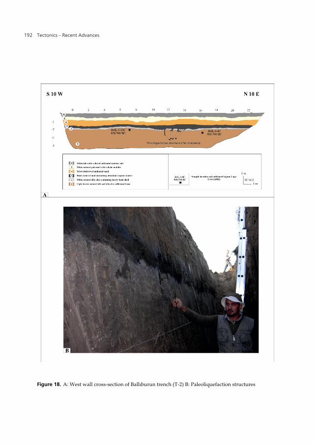
Kesiktepe Trench (T‐3)
The Troy fault enters the alluvium deposits of Karamenderes brook starting from the west
of Tevfikiye village and loses its morphologic trace. It becomes again morphologically
distinct in the sector between Ballıburun and the Aegean Sea (see Figure 3). In the highland
that is located west of Ballıburun and composed of Neogene aged Çanakkale formation is
known as “Kesik Tepe” (Truncated Hill) and this area is characterized by its “V” shaped
morphology. It is thought that this morphologic anomaly was initially shaped by Troy fault
and later modified by human activity. For the purpose of checking the anomaly, electrical
resistivity measurements were carried out along P‐5 profile from Kesiktepe location and
geoelectric cross‐section was obtained (see Figure 11‐F). In the geoelectric cross‐section, a
discontinuity was determined in the region where Kesik Tepe is located and for the purpose
of testing this discontinuity, Kesiktepe Trench was excavated, which is 6 meters long, 2
meters wide and 4.5 meters deep on average (Figure 3, T‐3).The trench cross section of
Kesiktepe trench is presented in Figure 19.
No sign of faulting was encountered in Kesiktepe trench. However, Kayan (2000) mentions
that Neogene deposits were cut at different depths in two drillholes very near to each other,
drilled in the south and north of Kesiktepe. According to the researcher, while the Neogene
deposits were cut at ‐2 meter in the south, they were cut at ‐8meter just in the north. This
indicates that the north block was relatively downthrown. As to support this, some signs of
discontinuity were encountered at the 96th meter on the geophysical profile number 5 (see
Figure 11‐F). On the other hand, it is known that, during Troy era, in Kumkale plain some
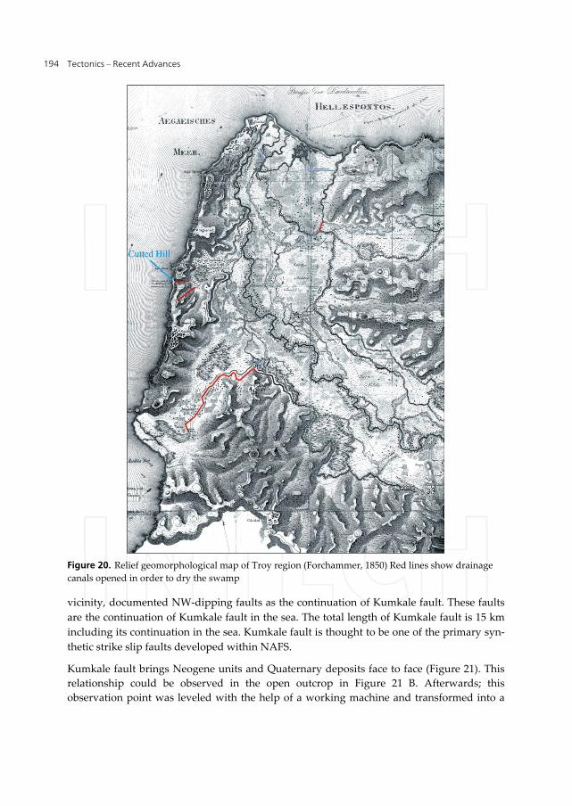
drainage canals were excavated in order to dry the swamp that caused malaria (personal
communication with Dr. Rüstem Aslan. 2005; Figure 20). And one of these drainage canals is
situated just on the Troy fault trace in Kesiktepe location. By means of the discontinuity in
the geoelectric cross‐section, archeological information and geomorphological approach, it is
thought that the Troy fault reaches the Aegean Sea over Kesiktepe. However, since the ca‐
nal, excavated as drying canal, was filled with recent sediments during the period from its
last activity to the present time, no trace of active faulting was encountered at the first 4
meters from the surface (from B.C. 1500 up to the present).
Kumkale Trench (T‐4)
In the Troy region, there are also NE‐SW oriented, right lateral strike slip faults that were
developed within NAFS. The best examples for these faults are Kumkale and Yenimahalle
faults (see figure 3). Kumkale fault is a N250E oriented, dipping 750 to NW right lateral strike
slip fault that borders from the north the ridge on which Kumkale village is situated.
Yaltırak et al. (2000), in their shallow sea seismic studies conducted in Dardanelles and its
Tectonics – Recent Advances
192
Figure 18. A: West wall cross‐section of Ballıburun trench (T‐2) B: Paleoliquefaction structures
An Assessment of the Earthquakes of Ancient Troy, NW Anatolia, Turkey
193
Figure 19. A: West wall cross section of Kesiktepe Trench (T‐3), B: Photograph of West Wall of Kesik‐
tepe Trench
Tectonics – Recent Advances
194
Figure 20. Relief geomorphological map of Troy region (Forchammer, 1850) Red lines show drainage
canals opened in order to dry the swamp
vicinity, documented NW‐dipping faults as the continuation of Kumkale fault. These faults
are the continuation of Kumkale fault in the sea. The total length of Kumkale fault is 15 km
including its continuation in the sea. Kumkale fault is thought to be one of the primary syn‐
thetic strike slip faults developed within NAFS.
Kumkale fault brings Neogene units and Quaternary deposits face to face (Figure 21). This
relationship could be observed in the open outcrop in Figure 21 B. Afterwards; this
observation point was leveled with the help of a working machine and transformed into a
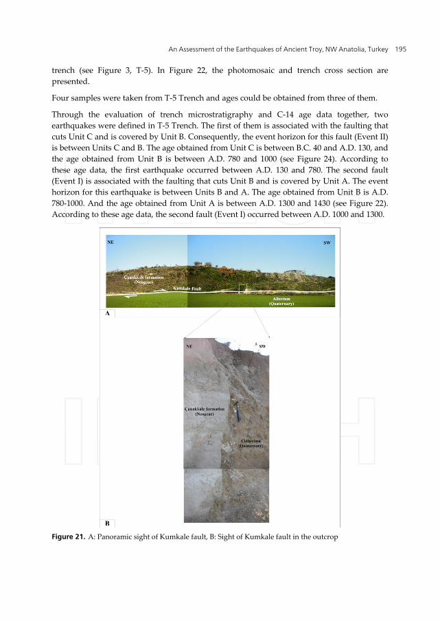
An Assessment of the Earthquakes of Ancient Troy, NW Anatolia, Turkey
195
trench (see Figure 3, T‐5). In Figure 22, the photomosaic and trench cross section are
presented.
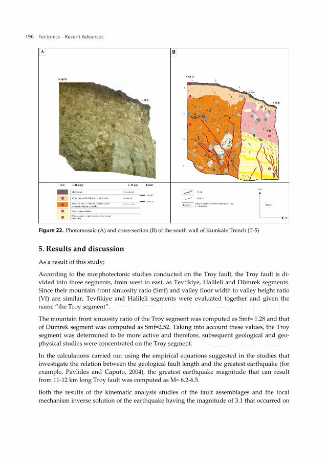
Four samples were taken from T‐5 Trench and ages could be obtained from three of them.
Through the evaluation of trench microstratigraphy and C‐14 age data together, two
earthquakes were defined in T‐5 Trench. The first of them is associated with the faulting that
cuts Unit C and is covered by Unit B. Consequently, the event horizon for this fault (Event II)
is between Units C and B. The age obtained from Unit C is between B.C. 40 and A.D. 130, and
the age obtained from Unit B is between A.D. 780 and 1000 (see Figure 24). According to
these age data, the first earthquake occurred between A.D. 130 and 780. The second fault
(Event I) is associated with the faulting that cuts Unit B and is covered by Unit A. The event
horizon for this earthquake is between Units B and A. The age obtained from Unit B is A.D.
780‐1000. And the age obtained from Unit A is between A.D. 1300 and 1430 (see Figure 22).
According to these age data, the second fault (Event I) occurred between A.D. 1000 and 1300.
Figure 21. A: Panoramic sight of Kumkale fault, B: Sight of Kumkale fault in the outcrop
Tectonics – Recent Advances
196
Figure 22. Photomosaic (A) and cross‐section (B) of the south wall of Kumkale Trench (T‐5)
5. Results and discussion
As a result of this study;
According to the morphotectonic studies conducted on the Troy fault, the Troy fault is di‐
vided into three segments, from west to east, as Tevfikiye, Halileli and Dümrek segments.
Since their mountain front sinuosity ratio (Smf) and valley floor width to valley height ratio
(Vf) are similar, Tevfikiye and Halileli segments were evaluated together and given the
name “the Troy segment”.
The mountain front sinuosity ratio of the Troy segment was computed as Smf= 1.28 and that
of Dümrek segment was computed as Smf=2.52. Taking into account these values, the Troy
segment was determined to be more active and therefore, subsequent geological and geo‐
physical studies were concentrated on the Troy segment.
In the calculations carried out using the empirical equations suggested in the studies that
investigate the relation between the geological fault length and the greatest earthquake (for
example, Pavlides and Caputo, 2004), the greatest earthquake magnitude that can result
from 11‐12 km long Troy fault was computed as M= 6.2‐6.5.
Both the results of the kinematic analysis studies of the fault assemblages and the focal
mechanism inverse solution of the earthquake having the magnitude of 3.1 that occurred on
An Assessment of the Earthquakes of Ancient Troy, NW Anatolia, Turkey
197
the Troy fault on 03.02.2008, indicate a strike slip with normal component faulting
developed under transtensional stress regime characterized by WNW‐ESE oriented
compression (P) and NNE‐SSW oriented tension (T) in the Troy region at the present time.
The fault systems in the Troy region and the stress regimes which are effective at the present
time show that strike‐slip faults and concordant normal faulting in active in the Troy region.
According to the Direct Current Resistivity profile studies conducted on profile lines
perpendicular to the fault trace along the Troy fault, it was understood that the Troy fault
passes 30‐100 meters north of the morphological escarpment which borders the Troy rise
from the north. This situation can be explained by means of the degradation of the Troy
fault scarp in the course of time. According to the geoelectric cross‐sections obtained from
the shallow geophysical studies, some discontinuity signs were encountered. However, it
was observed that these discontinuities do not reach the surface but come to an end at the
depth of about ‐10 meters from the surface.
In the Quaternary deposition area north of the Troy fault, in order to examine the lateral
thickness variation of the Quaternary deposits towards the fault, 5 shallow drilling works
with depths varying between 3 and 9 meters were conducted at 5 points along a direction
perpendicular to the Troy fault. When the information obtained from these drilling works
were transformed onto the three dimensional schematic geological cross‐section, it was seen
that the plane which constitutes the boundary between the Quaternary deposits and the
Neogene aged units gets thicker towards the south (towards the Troy fault). In other words,
this boundary is tilted towards the Troy fault. This corroborates the asymmetry of the basin
and at the same time points to the Quaternary activity of the Troy fault. From the paleo‐
seismological trench studies it was understood that no earthquake resulting from the Troy
fault occurred in the last 3000 years from B.C. 1190 up to the present, in Tevfikiye trench.
Since the thickness of the sediments accumulated on the fault during the period from the
last earthquake which resulted from the Troy fault up to the present was greater than the
depth that can be reached in paleoseismological trench works, it was not possible to reach
traces of faulting in the trench excavations.
In Ballıburun trench, some paleoliquefaction structures, developed during the time from
B.C. 760 up to the present as a result of an earthquake that was originated from the nearby
faults, were observed.
Two earthquakes were dated in the paleoseismological studies conducted on the Kumkale
fault. The first of these faults occurred between A.D. 130 and 780 and the second one
occurred between A.D. 1000 and 1300.
The paleoliquefaction structures observed in Ballıburun trench might have resulted from the
Kumkale fault.
In this study, it was understood that the earthquakes which destroyed Troy III and Troy VI
layers had not developed depending on the Troy fault system. Although their source is not
clearly known, these earthquakes might have originated from the active faults in Biga
Peninsula or from Gaziköy‐Saroz fault which represents the north branch of NAFS. The
Tectonics – Recent Advances
198
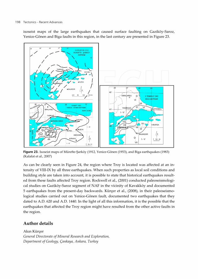
isoseist maps of the large earthquakes that caused surface faulting on Gaziköy‐Saroz,
Yenice‐Gönen and Biga faults in this region, in the last century are presented in Figure 23.
Figure 23. Isoseist maps of Mürefte‐Şarköy (1912, Yenice‐Gönen (1953), and Biga earthquakes (1983)
(Kalafat et al., 2007)
As can be clearly seen in Figure 24, the region where Troy is located was affected at an in‐
tensity of VIII‐IX by all three earthquakes. When such properties as local soil conditions and
building style are taken into account, it is possible to state that historical earthquakes result‐
ed from these faults affected Troy region. Rockwell et al., (2001) conducted paleoseismologi‐
cal studies on Gaziköy‐Saroz segment of NAF in the vicinity of Kavakköy and documented
5 earthquakes from the present‐day backwards. Kürçer et al., (2008), in their paleoseismo‐
logical studies carried out on Yenice‐Gönen fault, documented two earthquakes that they
dated to A.D. 620 and A.D. 1440. In the light of all this information, it is the possible that the
earthquakes that affected the Troy region might have resulted from the other active faults in
the region.
Author details
Akın Kürçer
General Directorate of Mineral Research and Exploration,
Department of Geology, Çankaya, Ankara, Turkey
An Assessment of the Earthquakes of Ancient Troy, NW Anatolia, Turkey
199
Alexandros Chatzipetros, Spyros Pavlides,
George Syrides, Kostas Vouvalidis and Özkan Ateş
Aristotle University of Thessaloniki, Faculty of Sciences,
Department of Geology, Thessaloniki, Greece
Salih Zeki Tutkun and Süha Özden
Çanakkale Onsekiz Mart University, Department of Geological Engineering, Çanakkale, Turkey
Emin Ulugergerli and Yunus Levent Ekinci
Çanakkale Onsekiz Mart University, Department of Geophysical Engineering, Çanakkale, Turkey
Acknowledgement
This study was supported by a bilateral cooperation project between TUBİTAK (The Scientific
and Technological Research Council of Turkey) and GSRT (General Secretariat for Research and
Tecnology). Grant: TUBİTAK ‐ 105Y360. We would like to warmly thank the following col‐
leagues that assisted in the fieldwork during various field periods: A. Michailidou, S. Sboras, S.
Valkaniotis, A. Zervopoulou (from Aristotle Universityof Thessaloniki, Department of Geology)
and Gündoğdu, Y (from Ankara University, Department of Geophysical Engineering).
6. References
Aksoy, M., E., Meghroui, M., Vallee, M. and Çakır, Z., 2010. Rupture characteristics of the is
A.D. 1912 Mürefte (Ganos) earthquake segment of the North Anatolian fault (western
Turkey). Geology, November 2010; v. 38; no. 11; p. 991‐994; doi: 10.1130/G31447.1.
Ambraseys, N.,N. and Finkel, C.,F., 1991. Long‐term seismicity of İstanbul and of the
Marmara region, Engin. Seis. Earthq. Engin. Report, 91/8, İmperial College.
Canıtez, N. and Toksöz, M.N. 1971. Focal mechanism and source depth of earthquakes from
body and surfacewave data. Bulletin of Seismological Society of America 61, 1369–79.
Carey, E.; 1976. Analyse numérique dʹun modéle mécanique élémentaire appliqué a lʹétude
dʹune population de failles : calcul dʹun tenseur moyen des contraintes a partir des
stries de glissement. Thése de 3º cycle, Université de Paris‐Sud, Orsay, 138 p.
Carey, E., 1979. Recherche des directions principales de contraintes associées au jeu dʹune
population de failles, Revue Geological Dynamic and Géography physic., 21, 57‐66
Jackson J., McKenzie D., 1984. Active tectonics of the Alpine–Himalayan Belt between
Western Turkey and Pakistan, Geophy. J. Royal Astr. Soc. 7 (1984) (1984) 185–264.
Kalafat, D. 1988. Active tectonics and seismicity of SW Anatolia and its vicinity. Bulletin of
Earthquake Research, 63, 5–98. Ankara (in Turkish with English abstract).
Kalafat, D., Güneş, Y., Kara, M., Deniz, P., Kekovalı, K., Kuleli, S., Gülen, L., Yılmazer, M., Özel,
N., 2007. A revised and extended earthquake cataloque for Turkey since 1900 (M≥ 4,0).
Boğaziçi University, Kandilli Observatory and Earthquake Research Institute, İstanbul.
Keller, A. E., and Pinter, N., 1996; Active Tectonics, Earthquakes, Uplift and Landscape.
Prentice Hall (ISBN 0‐02‐304601‐5) N. Jersey ‐pp. 377. (Second Edition 2002).
Kürçer, A. and Tutkun, S.Z., 2008. The role of the geological and tectonic processes on
geomorphological evolotuion of the Biga Peninsula, NW Turkey. National
Geomorphology Symposium, Abstracts, 213‐214. Çanakkale, 2008.
Tectonics – Recent Advances
200
Kürçer, A., 2006. Neotectonic Features of the vicinity of Yenice – Gönen and
Paleoseismology of March 18, 1953 (Mw:7,2) Yenice‐Gönen Earthquake Fault (NW
Turkey) (Çanakkale Onsekiz Mart University Natural and Applied Sciences Instıtue ‐
2006). p. 170 (in Turkish with English abstract).
Kürçer, A., ,Tutkun, S. Z., Pavlides, S., Chatzipetros, A., Ateş, Ö., Özden, S., , Ulugergerli, E.,
Gündoğdu, Y., Bekler, T., Syrides, G., Vouvalidis, K., Valkaniotis, S., Zervopoulou, A.,
Şengül, E., Ekinci, Y. L.,Köse K., Demirci, A. and Elbek, Ş., 2006, Morphotectonical
Features of Troia Fault and Preliminary Paleoseismological Studies, NW Turkey. 10th
Meeting of the Active Tectonic Research Group 10th. Proceedings; pp: 60., 2‐4
November 2006, Dokuz Eylül University, Department of Geology, İzmir.
Kürçer, A., Chatzipetros, A., Tutkun, S.Z., Pavlides, S., Ateş, Ö. and Valkaniotis, S. 2008. The
Yenice‐Gönen Active Fault (NW Turkey): Active Tectonics and Palaeoseismology,
Tectonophysics, 453, 263‐275.
McKenzie, D.P., 1972. Active tectonics of the Mediterranean region, Geophys. J. R. Astr. Soc.,
30 (2), 109‐185.
McKenzie, D.P., 1978. Active tectonics of the Alpine‐Himalayan belt: The Aegean sea and
surrounding regions (tectonics of aegean region), Geophys. J. R. Astr. Soc., 55, 217‐254.
Okay, I.A, (1987); Geology and tectonics of the western part of Biga peninsula. TPAO,
Report Number: 2374.
Özden, S.,Bekler, T., Tutkun, S. Z., Kürçer, A., Ateş, Ö., Bekler, F., Kalafat, D.,Gündoğdu, E.,
Bircan, F., Çınar, S., Çağlayan,Ö., Gürgen, M., İşler, H. and Yalçınöz, A., 2008,
Seismotectonics of Biga Peninsula and South of Marmara Sea. Active Tectonic Research
Group 12th. Abstracts; pp: 48‐49, Akçakoca, MTA, Turkey.
Pavlides, S. and Caputo, R., 2004. Magnitude versus faults’ surface parameters:quantitative
relationships from the Aegean. Tectonophysics, 380 (3–4), 159–188.
Rockwell, T., Barka, A., Dawson, T., Akyüz, S. and Thorup K. 2001. Paleoseismology of the
Gazikoy‐Saros segment of the North Anatolia fault, northwestern Turkey: Comparison
of the historical and paleoseismic records, implications of regional seismic hazard, and
models of earthquake recurrence. Journal of Seismology, 5: 433‐448.
Şaroğlu,F., Emre, Ö. and Kuşcu, İ., (1992), Active fault map of Turkey, MTA, Ankara.
Şengör, A.M.C., Görür, N. and Şaroğlu, F., 1985. Strike‐slip faulting and related basin
formation in zones tectonic escape: Turkey as a case study, in strike‐slip deformation,
Basin formation and Sedimentation, edited by Biddle, K.T. and Christie‐Blick, N., Soc.
Econ. Paleontol. Mineral. Spec. Publ., 37, 227‐264.
Şentürk, K. and Karaköse, C, 1987, Geology of Çanakkale strait and its vicinity, MTA Report
Number: 9333 (unpublished).
Taymaz, T. 2001. Active tectonics of the North and Central Aegean Sea. Symposia on
Seismotectonics of the North‐Western Anatolia‐Aegean and Recent Turkish
Earthquakes, XI‐XIX. Istanbul: ITU, 113 pp.
Tutkun, S.Z. and Pavlides, S.B. 2005. The Troy Fault, Bulletin of the Geological Society of
Greece, Vol. XXXVII, 194‐200.
Yaltırak, C., Alpar, B., Sakinc¸, M., Yüce, H., 2000. Origin of the Strait of Çanakkale
(Dardanelles): regional tectonics and the Mediterranean–Marmara incursion. Mar. Geol.
164, 139– 156 (with Erratum 167, 189–190).