Embed Size (px)
Citation preview
STATE OF CALIFORNIA-- THE RESOURCES AGENCY ARNOLD SCHW ARZENEGGER, Governor
CALIFORNIA COASTAL COMMISSION SAN DIEGO AREA
7575 ME1ROPOLJTAN DRIVE, SUITE 103
,AN DIEGO, CA 92108-4421
(619) 767-2370
Filed:
Fri 9c 49th Day: 180th Day: Staff: Staff Report:
December 10, 2003 January 28, 2004 June 7, 2004 BP-SD December 29, 2003 January 14-16, 2004 Hearing Date:
REGULAR CALENDAR STAFF REPORT AND PRELIMINARY RECOMMENDATION
Application No.: 6-03-54
Applicant: City of Solana Beach, Attn: Chandra Collure
Agent: Dokken Engineering, Attn: Chris Johnson
Description: Improvements to the Lomas Santa Fe/Interstate 5 (1-5) Interchange to include constructing new loop ramps, widening the I-5 overpass, adding northbound and southbound auxiliary lanes, installing a raised median in front of Lomas Santa Fe Plaza, rerouting Marine View Avenue at San Andres Drive, and installing retaining/sound walls, landscaping and drainage improvements. Acquisition of several small parcels of additional right of way is proposed as well as additional minor right of way acquisition for rerouting of Marine View Avenue.
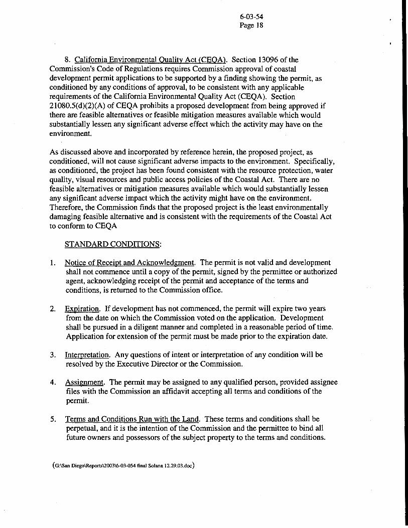
Site: Northbound and Southbound Interstate 5 (1-5) near Lomas Santa Fe Drive and Via de la Valle, Solana Beach (San Diego County)
STAFF NOTES:
Summary of Staffs Preliminary Recommendation:
Staff recommends approval of the proposed project with special conditions. The project raises issues related to impacts to native upland habitat, water quality, visual resources and public access. The proposed interchange improvements are necessary to address substandard levels-of-service (LOS) occurring at the interchange and surrounding roadways. While unavoidable impacts will occur to approximately 2.05 acres of Coastal Sage Scrub (CSS) habitat to accommodate the proposed improvements, the CSS is isolated, highly degraded and not occupied by gnatcatchers or other sensitive species. As such, the Commission's staff ecologist has found that the impacts will not occur to an Environmentally Sensitive Habitat Area (ESHA). Also, the Commission's staff ecologist has detennined that although some individual wetland indicator plants would be impacted by the project these are not native wetlands that are protected under the Coastal Act.
6-03-54 Page2
With the proposed mitigation measures and special conditions, the potential impacts on coastal resources will be eliminated or reduced to the maximum extent feasible, consistent with Coastal Act policies.
Substantive File Documents: Department of Transportation Letter, Interstate 5 Lomas Santa Fe Interchange Improvements-Draft Environmental Assessment & Initial Study; Informal Endangered Species Consultation for the Interstate 5/Lomas Santa Fe Interchange Improvements in San Diego, San Diego County, California (EA965100); Interstate 5/Lomas Santa Fe Interchange Improvements Final Biological Assessment October 2003
I. PRELIMINARY STAFF RECOMMENDATION:
The staff recommends the Commission adopt the following resolution:
MOTION: I move that the Commission approve Coastal Development Permit No. 6-03-54 pursuant to the staff recommendation.
STAFF RECOMMENDATION OF APPROVAL:
Staff recommends a YES vote. Passage of this motion will result in approval of the permit as conditioned and adoption of the following resolution and findings. The motion passes only by affirmative vote of a majority of the Commissioners present.
RESOLUTION TO APPROVE THE PERMIT:
The Commission hereby approves a coastal development permit for the proposed development and adopts the findings set forth below on grounds that the development as conditioned will be in conformity with the policies of Chapter 3 of the Coastal Act and will not prejudice the ability of the local government having jurisdiction over the area to prepare a Local Coastal Progr~ conforming to the provisions of Chapter 3. Approval of the permit complies with the California Environmental Quality Act because either 1) feasible mitigation measures and/or alternatives have been incorporated to substantially lessen any significant adverse effects of the development on the environment, or 2) there are no further feasible mitigation measures or alternatives that would substantially lessen any significant adverse impacts of the development on the environment.
II. Standard Conditions.
See attached page.
Ill. Special Conditions.
The permit is subject to the following conditions:
6-03-54 Page 3
1. Final Plans. PRIOR TO ISSUANCE OF THE COASTAL DEVELOPMENT PERMIT, the applicant shall submit to the Executive Director for review and written approval final plans for the permitted development that are in substantial conformance with the undated Caltrans plans received in the San Diego Coastal Commission office on December 12, 2003, with the application package.
The permittee shall undertake development in accordance with the approved final plans. Any proposed changes to the approved final plans shall be reported to the Executive Director. No changes to the approved final plans shall occur without a Coastal Commission-approved amendment to this coastal development permit unless the Executive Director determines that no amendment is legally required.
2. Coastal Sage Scrub Mitigation Plan. PRIOR TO THE ISSUANCE OF THE COASTAL DEVELOPMENT PERMIT, the applicant shall submit for review and written approval of the Executive Director, a final detailed coastal sage scrub mitigation plan that includes the following as proposed by the applicant:
a. A detailed site plan of the impact area that substantially conforms to the Final Biological Assessment, dated October, 2003, and the Informal Endangered Species Consultation for the I-S/Lomas Santa Fe Interchange Improvements in San Diego, San Diego County, California (EA965IOO), dated December 9, 2003. The final plan must delineate all impact areas, the types of impact (both permanent and temporary), and the exact acreage of each identified impact.
b. The Biological Assessment, dated October, 2003.
c. A detailed plan for the mitigation site(s) and a description of how the site(s) will be restored.
d. The following goals, objectives, and performance standards for the mitigation site:
1. Restoration of a minimum of 3.58 acres of area currently covered with ornamental landscaping or disturbed DSS (to include .40 acres off-site at the 11.68 acre mitigation site for the Del Mar Auxiliary Lane project in the San Dieguito Lagoon).
2. The coastal sage scrub at the mitigation site(s) shall be similar to nearby, relatively undisturbed stands of CSS in both species composition and ground cover in 5 years.
3. Planting of the new slopes adjacent to the site of the auxiliary lane(s) shall occur within 30 days of completion of construction.
6-03-54 Page4
e. The final design and construction methods that will be used to ensure the mitigation site achieves the defined goals, objectives, and performance standards.
f. Provisions for submittal, within 30 days of completion of initial restoration work, of "as built" plans demonstrating that the mitigation site has been established in accordance with the approved design and construction methods
The permittee shall undertake development in accordance with the approved mitigation plans. Any proposed changes to the approved plans shall be reported to the Executive Director. No changes to the approved plans shall occur without a Coastal Commission-approved amendment to this coastal development permit unless the Executive Director determines that no amendment is legally required.
3. Final Monitoring Program. PRIOR TO THE ISSUANCE OF THE COASTAL DEVELOPMENT PERMIT, the applicant shall submit for review and written approval of the Executive Director, a final detailed program for monitoring the proposed coastal sage scrub mitigation. The applicant shall develop the program in consultation with the U.S. Fish and Wildlife Service as appropriate. As proposed by the applicant, the monitoring program shall include the following:
a. Provisions for monitoring the revegetation of the coastal sage scrub mitigation site (s).
b. Provisions assessing the initial biological and ecological status of the "as built" mitigation site(s) within 30 days of establishment ofthe mitigation in accordance with the approved plans. The assessment shall include an analysis of the performance standards that will be monitored pursuant to the program, with a description of the methods for making that evaluation.
c. Provisions to ensure that remediation will occur within 60 days of a determination by the permittee or the Executive Director that monitoring results indicate the mitigation site does not meet the goals, objectives, and performance standards identified in the approved program.
d. Provisions for monitoring and remediation of the mitigation site in accordance with the approved final mitigation program for a period of five years, commencing upon submittal of the "as built" analysis.
e. Provisions for submission of annual reports of monitoring results to the Executive Director for the duration of the required monitoring period, with the first annual report due one year after submission of the "as-built" analysis. Each report shall also include a "Performance Evaluation" section evaluating the status of the mitigation and restoration projects in relation to the performance standards.

6-03-54 Page 5
f. Provisions for submission of a final monitoring report to the Executive Director at the end of the five-year reporting period. The final report must be prepared in consultation with a qualified biologist. The report must evaluate whether the mitigation site conforms with the goals, objectives, and performance standards set forth in the approved final mitigation program.
If the final reports indicate that the mitigation project has not met all approved performance standards, the applicant shall submit, for the review and written approval of the Executive Director, a revised or supplemental program to compensate for those portions of the original program which did not meet the approved performance standards. The revised program shall be processed as an amendment to this coastal development permit, unless the Executive Director determines that no amendment is legally required. The applicant will complete the development outlined in any such program, as approved.
The permittee shall monitor and remediate the mitigation and restoration site in accordance with the required monitoring program. Any proposed changes from the approved monitoring program shall be reported to the Executive Director. No change to the program shall occur without a Commission-approved amendment to the permit unless the Executive Director determines that no amendment is legally required.
4. Maintenance of Water Quality. PRIOR TO THE ISSUANCE OF THE COASTAL DEVELOPMENT PERMIT, the applicant shall submit a final detailed water quality program for review and written approval of the Executive Director. The applicant shall develop the program in consultation with the Regional Water Quality Control Board (RWQCB). The program shall consist of the following:
a. The applicant shall submit a Water Pollution Control Plan (WPCP) that addresses the issues of grading, drainage, erosion, and pollution control.
b. The WPCP shall include final grading plans for the entire alignment, with existing and proposed contours clearly delineated.
c. The WPCP shall include a Best Management Practices (BMP) Program addressing post-construction BMPs. This program shall include, but is not limited to, final drainage plans delineating the detention basin, bioswale and outlet facilities, and calculations/evidence that the facilities are designed to treat, infiltrate or filter the amount of stormwater runoff produced by all storms up to and including the 85th percentile, 24-hour storm event for volume-based BMPs, and/or the 85th percentile, 1-hour storm event, with an appropriate safety factor (i.e., 2 or greater), for flow-based BMPs.
d. The applicant shall propose an end-of-pipe flow-based BMP at outfall #6 to treat or filter runoff prior to discharge to Stephen's Creek. Runoff from improved southbound off-ramp and drainage areas #17 and #22- 26, as indicated on the submitted Preliminary Hydrology Report dated February 2002, shall be directed into pervious areas such as those proposed within drainage areas #16 and 38 for

6-03-54 Page6
treatment. The applicant shall also propose a BMP or BMPs to treat, infiltrate or filter runoff generated from the proposed auxiliary lanes. Potential options include end-of-pipe BMPs installed at Outfalls #1 - 5.
e. The WPCP shall include a Best Management Practices (BMP) Program addressing construction BMPs. This program shall include, but is not limited to, the following:
1. Debris and trash shall be disposed of in the proper trash and recycling receptacles at the end of each construction day.
2. The BMP program shall include a detailed plan for clean-up of accidental spill of petroleum-based products, cement, or other construction related pollutants. The plan shall be retained on-site with the contractor or engineer throughout construction. It shall include, but not be limited to, use of absorbent pads, or other similar and acceptable methods for clean-up of spills.
3. The construction phase BMP Program shall indicate the proposed staging areas during construction on the plans and cover those areas as well.
The permittee shall undertake development in accordance with the approved final BMP program. Any proposed changes to the approved final program shall be reported to the Executive Director. No changes to the approved BMP program shall occur without a Coastal Commission-approved amendment to this coastal development permit unless the Executive Director determines that no amendment is legally required.
5. Landscaping/Planting Plan. PRIOR TO THE ISSUANCE OF THE COASTAL DEVELOPMENT PERMIT, the applicant shall submit for review and written approval of the Executive Director, a final detailed landscaping plan for the project. The plan shall include the following:
a. A maintenance plan for the project site that describes the herbicide, pesticide and fertilizer practices as well as list the chemical pesticides and fertilizers that will be employed on site. Said chemicals shall not be toxic to fish or wildlife or persistent in the environment. Herbicides and pesticides, if used at all, shall be applied by hand application or by other means that will prevent leakage, percolation, or aerial drift into nearby lagoon, wetland and upland areas;
b. A plan showing the type, size, extent and location of all plant materials used. All trees removed by the project shall be replaced on a 1: 1 basis. Retaining/sound walls shall be colored and textured to be subordinate to the natural setting to the extent possible. In addition, where feasible, retaining/sound walls shall be screened with trees, shrubs or other landscape plants to help reduce their visibility.
6-03-54 Page7
c. Only species typical of coastal sage habitats shall be utilized, such that the slopes will be compatible with surrounding natural and manmade areas.
d. A planting schedule that indicates that the planting plan shall be implemented within 60 days of completion of the construction project;
e. All required plantings shall be maintained in good growing condition, and whenever necessary, shall be replaced with new drought-tolerant and native plant materials to ensure continued compliance with landscape requirements. No invasive species are permitted; and
f. Five years from the date of issuance of the coastal development permit, the applicant shall submit a landscape monitoring report for review and written approval of the Executive Director. The report shall be prepared by a licensed Landscape Architect or qualified Resource Specialist, and certify that the on-site landscaping is in conformance with the landscape/planting plan approved pursuant to this Special Condition. The monitoring report shall include photographic documentation of plant species and plant coverage.
If the landscape monitoring report indicates the landscaping is not in conformance with or has failed to meet the performance standards specified in the landscaping plan approved pursuant to this permit, the applicant, or successors in interest, shall submit a revised or supplemental landscape plan for the review and written approval of the Executive Director or Commission. The revised landscaping plan must be prepared by a licensed Landscape Architect or Resource Specialist and shall specify measures to remediate those portions of the original plan that have failed or are not in conformance with the original approved plan. The revised plan shall be processed as an amendment to this coastal development permit, unless the Executive Director determines that no amendment is legally required. The applicant will complete the development outlined in any such program, as approved.
The permittee shall undertake the development in accordance with the approved planting plans. Any proposed changes to the approved planting plans shall be reported to the Executive Director. No changes to the planting plans shall occur without a Coastal Commission approved amendment to this coastal development permit unless the Executive Director determines that no amendment is legally required.
6. Other Permits. PRIOR TO THE COMMENCEMENT OF CONSTRUCTION, the permittee shall provide to the Executive Director copies of all other required state or federal discretionary permits for the development authorized by CDP #6-03-54. The applicant shall inform the Executive Director of any changes to the project required by other state or federal agencies. Such changes shall not be incorporated into the project until the applicant obtains a Commission amendment to this permit, unless the Executive Director determines that no amendment is legally required.

6-03-54 Page 8
7. Construction Schedule/Access Impacts/Seasonal Restrictions. PRIOR TO ISSUANCE OF THE COASTAL DEVELOPMENT PERMIT, the applicant shall submit to the Executive Director for review and written approval, a final construction schedule, which shall be incorporated into construction bid documents. The schedule shall include the following:
a. Adverse effects on traffic flow on Lomas Santa Fe Drive shall be minimized during the summer months and at least one traffic lane in each direction shall remain open at all times.
b. Construction activities, including removal of vegetation, shall not occur within the California gnatcatcher breeding season (February 15- August 31) of any year without the concurrence of the U.S. Fish and Wildlife Service and the California Department of Fish and Game.
c. If nests are found, a 500-foot buffer from construction activities shall be established and maintained until the nest is no longer active.
The permittee shall undertake the development in accordance with the approved construction schedule. Any proposed changes to the approved construction schedule shall be reported to the Executive Director. No changes to the construction schedule shall occur without a Coastal Commission approved amendment to this coastal development permit unless the Executive Director determines that no amendment is legally required.
IV. Findings and Declarations.
The Commission finds and declares as follows:
1. Detailed Project Description. The City of Solana Beach is proposing construction of several interrelated highway improvements primarily within the right-ofway of Interstate 5 (1-5). The project proposes the following:
• Constructing loop on-ramps in the northwest and southeast quadrants of the Lomas Santa Fe Interchange
• Widening the Lomas Santa Fe underpass to accommodate sidewalks, bike lanes and the ultimate on-ramp alignments required for future freeway widening
• Widening the 1-5 overpass structure to accommodate the ultimate width of 1-5 for the future freeway widening and lengthening the southbound off-ramp to increase storage capacity
• Realigning the existing northbound off-ramp to provide acceptable intersection spacing between the ramp connections
• Installing north- and southbound auxiliary lanes along 1-5 from Via de la Valle to Lomas Santa Fe Drive
• Constructing several sound walls that range in height from 8-feet to 12-feet on adjacent private property to mitigate freeway noise levels

• Constructing several retaining walls along 1-5.
6-03-54 Page9
• Acquisition of additional right of way of several small private parcels and through the rerouting of Marine View A venue.
The proposed project is located along 1-5 and extends from just north of Via De La Valle to just north of Lomas Santa Fe Drive (in both directions) in the City of Solana Beach. The purpose of the 1-5/Lomas Santa Fe Drive Interchange modifications is to provide capacity, operational and safety improvements that meet the objectives outlined in the Solana Beach General Plan in agreement with the Department of Transportation (Caltrans), to alleviate traffic congestion, delays and accidents. The intersection of Lomas Santa Fe Drive and the northbound 1-5 ramps is currently operating below city and state standards at a Level of Service (LOS) E. According to the applicant, the increase in intensity of use of existing developed areas in the City of Solana Beach will increase traffic volumes in the project vicinity causing further LOS reductions and an escalation of time delays.
Because there is no certified LCP for this area, the standard of review for this development is the Chapter 3 policies of the Coastal Act.
2. Environmentally Sensitive Habitat Areas (ESHA). The Coastal Act addresses the protection of Environmentally Sensitive Habitat Areas (ESHA).
Section 30240.
(a) Environmentally sensitive habitat areas shall be protected against any significant disruption of habitat values, and only uses dependent on those resources shall be allowed within those areas.
(b) Development in areas adjacent to environmentally sensitive habitat areas and parks and recreation areas shall be sited and designed to prevent impacts which would significantly degrade those areas, and shall be compatible with the continuance of those habitat and recreation areas.
Two habitat types, ornamental landscaped vegetation and mixed Diegan coastal sage scrub (DCSS)/ruderal vegetation, exist within the limits of the Biological Study Area (BSA). Nonnative ornamental landscaping is the main vegetation type. Eucalyptus and Canary Island pine are the dominant ornamental trees present along 1-5 and along the on/off-ramps. Oleander is the dominant species within the freeway median; palm species, hottentot-fig and other ornamental plantings are also present in small stands or as scattered individuals. The manufactured slopes contain sparse DCSS mixed with ruderal vegetation.
A 455-foot long concrete-lined ditch is located east of and parallel to 1-5 at the toe of a fill slope that was constructed for the freeway. The ditch was constructed to direct runoff from the adjacent slope and adjacent commercial and residential development and is largely devoid of vegetation but does contain some small patches of New Zealand

6-03-54 Page 10
spinach, wild radish and white watercress. The Commission's staff ecologist has determined that although the concrete drainage ditch apparently has retained enough sediment in places to support some individual wetland indicator plants, "these do not appear to be either wetland or otherwise ESHA. No rare species have been documented within the study area."
A portion of the project site is within Unit 3 (North San Diego County Multiple Habitat Conservation Plan [MHCP]) of the Critical Habitat designated for the California gnatcatcher. Unit 3 encompasses 32,46S acres occurring within the cities of Carlsbad, Encinitas, Escondido, Oceanside, San Marcos, Solana Beach, and Vista. Within the project site it covers a portion of the slope west of the southbound off ramp from I-S, north of Lomas Santa Fe Drive. However, no gnatcatchers have been observed during field surveys of the project area.
According to project biologists, the project area contains minor habitat value. The DCSS within the project limits is extremely sparse, of minimal quality and interspersed with ornamental, nonnative species. The proximity of the project to I-S, commercial, and residential developments, and the lack of open space on the site and in the project vicinity, makes the project area undesirable for most wildlife species. The DCSS present on the freeway slopes lacks the necessary constituent element of California gnatcatcher habitat. Constituent elements are defined as those habitat components essential for the primary biological needs of the coastal California gnatcatcher (i.e., foraging, nesting, rearing of young, communication, roosting, dispersal, reproduction or sheltering). According to the EIR, "the disturbed nature of the DCSS habitat on the slopes adjacent to heavily developed areas, would not be essential to any of the primary biological needs of the species."
Clearing, grading, and site preparation activities are proposed to begin in September, 200S, which is outside of the gnatcatcher breeding season (February 1S through August 31). Project construction is anticipated to take a maximum of 16 months. All cut and fill slopes that will be impacted by the proposed project will be revegetated with CSS plant species.
Project grading would eliminate approximately 2.0S acres of disturbed DCSS vegetation; approximately 0.40 acres of it is within Unit 3. The DCSS vegetation will be displaced through installation of a retaining wall to the west of the southbound off-ramp. The remainder of disturbed DCSS that will be impacted by the project is primarily distributed in long narrow patches south of the I-S/Lomas Santa Fe Interchange. A single patch is immediately north of the interchange along the on-ramp to I-S. The patches to the south of the interchange are isolated from occupied DCSS habitat in the San Dieguito Lagoon watershed by the development around the I-SNia de la Villa Interchange. The patch along the northbound lanes and immediately north of the I-S/Lomas Santa Fe Interchange is isolated from the San Elijo Lagoon by development along the Lagoon and non-native grasslands interspersed with scattered DCSS species.
Since the small patch of DCSS within designated critical habitat for the gnatcatcher is over 1,200 feet from occupied habitat and is isolated by development, iceplant and non-
6-03-54 Page 11
native grassland, it is unlikely to be utilized by breeding gnatcatchers. However, there is always the potential for a dispersing gnatcatcher to move along the slopes above the 1-5 southbound lanes. Since the remaining disturbed DCSS is patchy and isolated from both San Elijo and San Dieguito lagoons, they are unlikely to be utilized by breeding gnatcatchers. However, because of the potential for gnatcatchers being present in the future, preconstruction surveys are proposed by the applicant and required by USFWS. Special Condition #7 requires that construction activities must not occur within the California gnatcatcher breeding season (February 15- August 31) of any year without the concurrence of the U.S. Fish and Wildlife Service and the California Department of Fish and Game. If gnatcatchers are found, a 500-foot buffer from construction activities shall be established and maintained until the nest is no longer active.
The Commission staff ecologist has reviewed the project and agrees that the DCSS that will be impacted by the project is not considered ESHA. In this particular case, the Commission finds the DCSS does not meet the standards for support of rare species and as such, is not considered ESHA. This is supported by the fact that the freeway slopes were originally planted with native vegetation primarily for erosion control purposes and not as mitigation for any environmental impacts. In addition, at the time of construction of the original freeway, there was an expectation that the slope would be altered or destroyed in the future in order to accommodate the needs for highway maintenance or increased highway capacity.
Several alternatives were reviewed to document that the proposed project is the least environmentally-damaging as impacts can not be avoided or further reduced. Two project alternatives, in addition to the Preferred Alternative, were considered and rejected. Alternative A includes a southbound loop on-ramp in the northwest quadrant of the interchange to eliminate left-turn movements from Lomas Santa Fe Drive to southbound 1-5. A retaining wall would be required along the west side of the realigned southbound off- ramp to minimize impacts to the adjacent commercial property. The existing southbound on-ramp would be modified to accommodate eastbound traffic only. The northbound on and off-ramps would be shifted to the west to increase intersection spacing between the northbound ramps and Santa Helena/Marine View A venue on Lomas Santa Fe Drive. An auxiliary lane would be constructed along the freeway to accommodate an additional lane on the northbound off-ramp. Two left-turn and two right-turn lanes would be provided at the intersection of the northbound off-ramp and Lomas Santa Fe Drive. The alternative would widen the existing undercrossing on both sides of the structure. The location of the bridge columns adjacent to the curb and gutter sections on Lomas Santa Fe Drive would prohibit the provision of double left-turn lanes for eastbound traffic accessing the northbound on-ramp. Alternative A was rejected because it did not further project goals to reduce traffic to below LOS F during the PM peak period in year 2020 in two key areas (northbound ramps intersection and the Marine View Avenue/Santa Helena intersection on Lomas Santa Fe Drive).
Alternative B includes modifications to the northbound off-ramp and an adjacent section of Lomas Santa Fe Drive. The improvements would add a left-turn pocket to the northbound off-ramp and a right-turn lane for eastbound Lomas Santa Fe Drive traffic accessing Marine View A venue. This low-cost alternative would increase the storage
6-03-54 Page 12
capacity of the northbound off-ramp and avoid impacts to Marine View A venue. However, Alternative B was rejected because, although it would serve as an interim solution, it would not improve the interchange as a whole, and, as a result, the Marine View A venue/Santa Helena intersection on Lomas Santa Fe Drive would operate at LOS F during the PM peak period in year 2020. In addition, the southbound ramps intersection would operate at LOS F during both the AM and PM peak periods in year 2020. The Commission has reviewed the proposed alternatives and concurs that the proposed project, the preferred alternative, is the less environmentally damaging alternative.
The applicant has proposed a comprehensive mitigation/monitoring package to address unavoidable impacts to disturbed DCSS and to provide beneficial effects to the California gnatcatcher. As noted, all cut and fill slopes that will be impacted by the proposed project will be revegetated with DCSS plant species (approximately 3.58 acres total) with approximately 0.40 acres of DCSS to be planted at a proposed off-site mitigation site (within the boundaries of the San Dieguito River Park, immediately west of 1-5 and north of Racetrack View Drive). The applicant wants to make it clear that the revegetation of slopes along 1-5 is not creating ESHA. This revegetation is considered temporary for at least 10 years after project construction until future widening ofl-5 is completed at which time the final 1-5 fill slope shall be permanently revegetated with CSS. Because ESHA is not being created, no other off-site measures will be required to offset impacts to DCSS along the cut and fill slopes from future 1-5 widening. However, after each future construction project in this area, the 1-5 cut and fill slopes shall be revegetated with native CSS species.
The USFWS has found the proposed impacts and mitigation to be acceptable provided some additional provisions are followed. Some of the key provisions include that all clearing, grading, and site preparation activities shall be completed outside of the gnatcatcherbreeding season (February 15 through August 31); that all Environmentally Sensitive Areas outside of the project footprint shall be demarcated and that the project must be compliant with all conservation measures.
To memorialize the applicant's proposed mitigation/monitoring program and assure it includes the USFWS provisions detailed above, Special Conditions #2 and #3 are proposed. These conditions require submittal of the final mitigation and monitoring program/plans.
Special Condition #5 outlines the required planting program for project impacts to disturbed areas. A maintenance plan must be submitted describing proposed herbicide, pesticide and fertilizer practices as well as list the chemical pesticides and fertilizers that will be employed on site. Only species typical of coastal sage habitats shall be utilized to plant slopes. All required plantings shall be maintained in good growing conditions, and whenever necessary, shall be replaced with new drought-tolerant and native plant materials to ensure continued compliance with landscape requirements.
6-03-54 Page 13
Special Condition #6 requires submittal of copies of all permits required by other state and federal wildlife and regulatory agencies. If those final approvals differ from, or conflict with, this permit, a permit amendment may be required.
In summary, the Commission finds that the proposed construction activities are consistent with Section 30240 of the Coastal Act. The existing degraded DCSS on the manufactured highway slopes that is proposed to be impacted by the project is not ESHA, and is not part of any natural ecosystem. In addition, the applicant is proposing to provide mitigation for all impacts to the disturbed DCSS. Therefore, as conditioned, the Commission finds the proposal consistent with the biological resource policies of the Coastal Act.
3. Traffic Circulation/Public Access. Numerous Coastal Act policies address public access, all with the intent of providing, protecting, and enhancing coastal access. Those most applicable state, in part:
Section 30210.
In carrying out the requirement of Section 4 of Article X of the California Constitution, maximum access, which shall be conspicuously posted, and recreational opportunities shall be provided for all the people consistent with public safety needs and the need to protect public rights, rights of private property owners, and natural resource areas from overuse.
Section 30211.
Development shall not interfere with the public's right of access to the sea where acquired through use or legislative authorization, ....
I-5 is the primary north-south coastal access route in San Diego County, with virtually every interchange providing a means to reach the shoreline. It is also the most direct commuter route between San Diego, Los Angeles and Orange County, and experiences heavy traffic congestion during peak hours daily. The purpose of the I-5/Lomas Santa Fe Drive Interchange modifications is to alleviate traffic congestion, delays and accidents. Direct access from I-5 to Solana Beach is possible via interchanges at either Lomas Santa Fe Drive, within the city limits of Solana Beach, or Via de la Valle, outside the city limits to the south. These two interchanges represent the only transportation links for Solana Beach across state right-of-way. Additionally, I-5 functions as a north-south interregional connection between Solana Beach and the cities of Encinitas, Carlsbad and Oceanside to the north and southern San Diego County.
The intersection of Lomas Santa Fe Drive and the northbound I-5 ramps is currently operating below city and state standards with a level of service (LOS) E. Ramp intersections operating at LOS E are subject to speed reductions and extended queues affecting both ramp and the freeway traffic operations. Heavy right-turn movements onto Lomas Santa Fe Drive from the northbound off-ramp of I-5, non-standard intersection spacing between the northbound ramps and Marine View A venue, prolonged signal
6-03-54 Page 14
phasing required to coordinate all traffic movements, and left-turn maneuvers for eastbound and westbound traffic from Lomas Santa Fe Drive to the freeway on-ramps have contributed to the traffic congestion and delays. Year 2030 capacity forecasts indicate that without the proposed improvements Lomas Santa Fe Drive at both the northbound and southbound ramp intersections will perform below standard at LOS E and F during peak hours.
A solution to the regional circulation problem is beyond the scope of the proposed development, although the project not only will make entering and exiting the freeway easier, it will improve flow on Lomas Santa Fe which does affect public access to the beach. As proposed, at least one traffic lane will be open on Lomas Santa Fe during all phases of the project. The Coastal Act concerns itself with public access to beaches and recreational sites, not with general traffic circulation. Fortunately, morning recreational peaks do not coincide with commuter peaks, although there is some overlap in the afternoon. Since Lomas Santa Fe Drive provides access to the beaches of Solana Beach the proposed development may have a positive effect on public access to these identified destination points.
There will be no permanent lane closures on 1-5 or Lomas Santa Fe Drive during construction. The only temporary lane closures anticipated will be for erecting falsework and placement of pre-cast girders for the bridge widening. Furthermore, this temporary closure would be reserved for off-peak night work. The Commission is requiring in Special Condition #7 that at least one lane in each direction be open on Lomas Santa Fe Drive at all times and that adverse effects of traffic flow on Lomas Santa Fe Drive be minimized during the summer months. Only as conditioned to ensure that public access to the coast is not adversely affected is the project consistent with the above Coastal Act policies.
4. Water Quality. The following Coastal Act policy is most applicable to the proposed development:
Section 30231
The biological productivity and the quality of coastal waters, streams, wetlands, estuaries, and lakes appropriate to maintain optimum populations of marine organisms and for the protection of human health shall be maintained and, where feasible, restored through, among other means, minimizing adverse effects of waste water discharges and entrainment, controlling runoff, preventing depletion of ground water supplies and substantial interference with surface water flow, encouraging waste water reclamation, maintaining natural vegetation buffer areas that protect riparian habitats, and minimizing alteration of natural streams.
While proposed work is located primarily within the 1-5 right-of-way, indirect impacts to water quality from runoff over the proposed impervious surfaces both during construction and post-construction is a concern. Such runoff can carry sediments and urban pollutants and deposit them in downstream sensitive receiving waters. Pursuant to its National Pollutant Discharge Elimination System (NPDES) permit under which it constructs and
6-03-54 Page 15
operates highway development, Caltrans must implement Best Management Practices (BMPs) to limit polluted runoff from highway facilities.
Standard erosion control practices are proposed to minimize soil erosion following construction activities. Typical measures utilized during construction include applications of water or dust palliatives during earthwork activities, fiber rolls for slope stability and sediment control, temporary construction entrances to prevent sediment tracking on paved surfaces, gravel bags, temporary concrete washouts for concrete spoils, contour grading, sweeping, no work during high wind days, and haul road sealing.
Permanent erosion and sedimentation control features may include but will not be limited to the following: installation of replacement landscaping, hydro-seeding of steeper cut slopes, placement of straw on fill slopes to minimize erosion, improvement of drainage facilities to handle excess runoff and installation or replacement of desilting basins.
The proposed improvements will add new impermeable surfaces (auxiliary lanes and ramps). Any increase in impermeable surfaces will increase the contaminant load and rate of runoff. The proposed project includes drainage improvements that would enhance the quality of runoff entering Stephens Creek (and ultimately San Dieguito Lagoon) by installing a vegetated bioswale and detention basin. These facilities would detain runoff, allowing sediments to settle out and water to percolate into the soil, and would also filter pollutants from the runoff. However, the applicant has not shown that the proposed improvements are adequate to meet the water quality standards established by Coastal Act section 30231. The Commission typically requires calculations/evidence that the facilities are designed to treat, infiltrate or filter the amount of storm water runoff produced by all storms up to and including the 85th percentile, 24-hour storm event for volume-based BMPs, and/or the 85th percentile, 1-hour storm event, with an appropriate safety factor (i.e., 2 or greater), for flow-based BMPs.
As such, Special Condition #4 is proposed. This condition requires the applicant to submit a detailed water quality program for the project. The BMP program should include a detailed plan for clean-up of accidental spill of petroleum-based products, cement, or other construction related pollutants. The plan shall be retained on-site with the contractor or engineer throughout construction. It shall include, but not be limited to, use of absorbent pads. According to the Commission's water quality staff, for the auxiliary lanes, BMPs should be installed at Outfalls #1- #5 such as installing a grassy median. With respect to the undercrossing area, drainage areas #22- #26 currently dump their runoff into pipes that lead directly to Outfall #6 without treatment. An end-of-pipe flow-based BMP could be installed at the outfall. Runoff from these areas could also be directed to pervious areas in drainage areas #16, #17, #32, and #38 for treatment. Because the grassy swales currently being proposed for drainage areas #16 and #38 are designed to handle 2-year storm events, they may be able to handle additional input and treat the water to the 85th percentile standard, instead of the 2-year storm events. Finally, the Water Pollution Control Plan to be submitted should indicate staging areas during construction on the plans. The Commission finds that all runoff from the project site should be treated as identified above. With these measures, runoff ultimately reaching
-- --------~~-~-~~~~----------------------------------.
6-03-54 Page 16
the lagoon/river and ocean would be cleaner and lower in both volume and speed than at present.
In summary, as conditioned, the increase in impermeable surfaces resulting from the proposed project is offset by the drainage and runoff improvements either proposed in the development or recommended by Commission water quality staff. As conditioned, the Commission finds the proposal consistent with Section 30231 of the Act.
5. Visual Resources. The following policy of the Coastal Act addresses visual resources, and states, in part:
Section 30251
The scenic and visual qualities of coastal areas shall be considered and protected as a resource of public importance. Permitted development shall be sited and designed to protect views to and along the ocean and scenic coastal areas, to minimize the alteration of natural land forms, to be visually compatible with the character of surrounding areas, and, where feasible, to restore and enhance visual quality in visually degraded areas ....
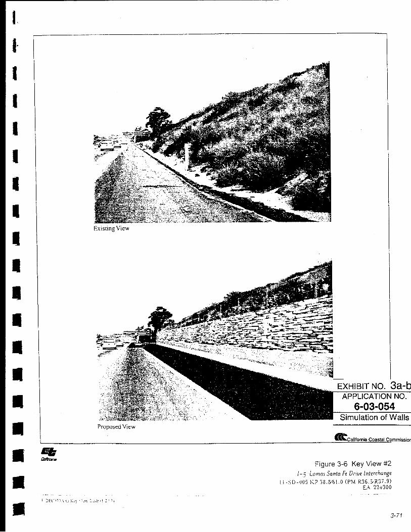
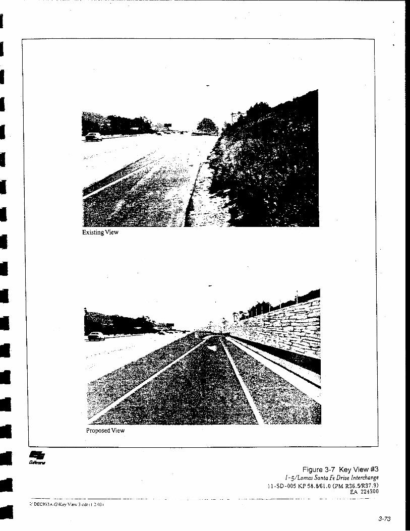
The project site is well inland from the actual shoreline; however, 1-5 is a designated scenic corridor and major coastal access route. Decoratively textured sandstone colored retaining walls are proposed along the proposed auxiliary lanes; additionally, a number of sound walls are proposed along several streets in the area to protect residences. The walls are proposed at varying heights that range in height from 8-feet to 12-feet. The walls will be visible to travelers along 1-5 in both directions. Current views of sparsely vegetated slopes and ice plant covered embankments on the freeway will be partially replaced with retaining walls at the lower levels resulting in a more urban view. However, the short duration of exposure (5 to 10 seconds) is expected to be minimal. The freeway in this location is surrounded by slopes on either side and no ocean views are impacted by the project. The retaining walls are all at freeway level and staggered for the most part to minimize any "tunnel" effect as you pass along the freeway. However, the proposed retaining walls should be colored and textured to be subordinate to the natural setting to the extent possible. Several of the sound walls will be Y2 glass and others will be colored and textured. To further reduce the visibility of the proposed walls, Special Condition #5 requires that, where it is feasible, walls should be screened with landscaping. In addition, areas disturbed by construction and newly constructed freeway slopes should be revegetated with native, drought tolerant plant materials to minimize adverse impacts associated with the proposed project to the extent possible. These requirements are incorporated as Special Condition #5.
Replacement freeway landscaping is proposed wherever existing ornamental landscaping will be removed. Native/ruderal slopes will be revegetated with a noninvasive hydroseed mix. Planting pockets between concrete safety barriers and retaining walls will be used to screen them from the views of passing motorists. The proposed pine and palm trees should provide tall trees at maturity. Large and medium sized shrubs are proposed as
6-03-54 Page 17
well as low flowering groundcover. The Commission finds that based on I-5's status as a scenic corridor, all trees proposed for removal must be replaced on a 1:1 basis. Special Condition #5 memorializes this requirement.
In summary, while the proposed project will result in a more "hardened" landscape through this stretch of I-5 with the installation of additional road surface and retaining walls, proposed and required landscape improvements will help to soften the views and reduce the impacts by screening, where feasible. In addition, no public views of the coastline are currently available or will be affected by the proposed development. Therefore, as conditioned, the Commission finds the proposed project consistent with Section 30251 of the Coastal Act.
6. Growth Inducement. Section 30254 of the Coastal Act is applicable and states, in part:
New or expanded public works facilities shall be designed and limited to accommodate needs generated by development or uses permitted consistent with the provisions of this division; ....
The project is proposed to improve traffic flows from planned development in the City of Solana Beach. To be found consistent with Section 30254 of the Coastal Act, the Commission must find that the project is being proposed to serve existing development, or that if it would accommodate new development, such development must be at planned and approved densities. The proposed interchange and lane upgrades will be located within a developed urban area and are intended to provide safe and adequate traffic circulation for motorists, not for the purpose of increasing the intensity of use of the freeway. Therefore, the proposed improvements should not have a significant overall inducement to growth within the coastal zone, and the development is consistent with section 30254 of the Coastal Act.
7. Local Coastal Planning. Section 30604(a) also requires that a coastal development permit, or permit amendment, shall be issued only if the Commission finds that the permitted development will not prejudice the ability of the local governmentto prepare a Local Coastal Program (LCP) in conformity with the provisions of Chapter 3 of the Coastal Act. In this case, such a finding can be made for the proposed project.
The subject site is located primarily within Caltrans right-of-way in the City of Solana Beach. Because there is no certified LCP for this area, the standard of review for this development is Chapter 3 policies of the Coastal Act. The proposed improvements will result in enhanced access to the City and improve the public's ability to access the beach which is located at the western terminus of Lomas Santa Fe Drive. Therefore, the Commission finds that the proposed development, as conditioned, is consistent with all applicable Chapter 3 policies of the Coastal Act and will not prejudice the ability of the City of Solana Beach to obtain a certified Local Coastal Program.
6-03-54 Page 18
8. California Environmental Quality Act (CEQA). Section 13096 of the Commission's Code of Regulations requires Commission approval of coastal development permit applications to be supported by a finding showing the permit, as conditioned by any conditions of approval, to be consistent with any applicable requirements of the California Environmental Quality Act (CEQA). Section 21080.5(d)(2)(A) of CEQA prohibits a proposed development from being approved if there are feasible alternatives or feasible mitigation measures available which would substantially lessen any significant adverse effect which the activity may have on the environment.
As discussed above and incorporated by reference herein, the proposed project, as conditioned, will not cause significant adverse impacts to the environment. Specifically, as conditioned, the project has been found consistent with the resource protection, water quality, visual resources and public access policies of the Coastal Act. There are no feasible alternatives or mitigation measures available which would substantially lessen any significant adverse impact which the activity might have on the environment. Therefore, the Commission finds that the proposed project is the least environmentally damaging feasible alternative and is consistent with the requirements of the Coastal Act to conform to CEQA
STANDARD CONDITIONS:
1. Notice of Receipt and Acknowledgment. The permit is not valid and development shall not commence until a copy of the permit, signed by the permittee or authorized agent, acknowledging receipt of the permit and acceptance of the terms and conditions, is returned to the Commission office.
2. Expiration. If development has not commenced, the permit will expire two years from the date on which the Commission voted on the application. Development shall be pursued in a diligent manner and completed in a reasonable period of time. Application for extension of the permit must be made prior to the expiration date.
3. Interpretation. Any questions of intent or interpretation of any condition will be resolved by the Executive Director or the Commission.
4. Assignment. The permit may be assigned to any qualified person, provided assignee files with the Commission an affidavit accepting all terms and conditions of the permit.
5. Terms and Conditions Run with the Land. These terms and conditions shall be perpetual, and it is the intention of the Commission and the permittee to bind all future owners and possessors of the subject property to the terms and conditions.
( G:\San Diego\Reports\2003\6-03-054 final Solana 12.29.03.doc)
() 0 3 3 ~-
cr ::>
~ North
I
8£/li.W PliA"'X'
,r ... ;, IF-1, ' LhE.:!./1
FLETCHER COVE
BEA"H PARK
1187
~m rm-uX g .ci
~- 8 §; ~ SITE VICINITY MAP Job: 0111223-1 g 6 (j z THERN CALIFORNIA Lomas Santa Fe at 1-5 Figure: 1 ~ ~ Z 9 IL & TESTING, INC. Solana Beach, California
~ 5 ~t=~~==~--~------1_---------=~~~~--~-----------------l----------------------~

J: (.)
U5 OJ <( z ::i 0 en
<i .. ;)
~
=oo <~ :Sz 1-4< ~~
··w < ":f
en 1-z w ::!: w > 0 0:: D.. ~
Cl 0 EXHIBIT NO. 2 w z en w 0 APPLICATION NO. I Cl D.. 0 w 0:: 6-03-054 ...J D..
I Site Plan
Ccalifomia Coastal Commission
I·
I
I
I
I
I I
I I
I
I
I
I
I
I
II
•
EXHIBIT NO. 3a-b APPLICATION NO.
6-03-054 Simulation of Walls
£california Coastal Commission
Figure 3-6 Key View #2 I -5 Lomas Santa Fe Drive Interchange
\ l-:)0-1]05 KP .13.8161.0 (PM R36.:YR37.9) L\ 22+300
3-71
I I I I I I I I I I I I I I I
• • • •
Existing View
Proposed View
I:' OEC933A,G\Kcy View 3.cdr tl ::031
Figure 3-7 Key View #3 I-5/Lomas Santa Fe Drive Interchange
ll-SD -005 KP 58.816!.0 (PM R36.51R37 .9) EA 224300
3-73