Embed Size (px)
Citation preview
Prepared for Alex Droic May 29, 2015.
North-South Environmental Inc. 35 Crawford Crescent, Suite U5 P.O. Box 518 Campbellville, Ontario L0P 1B0
754 Stone Road East Environmental Impact Study – DRAFT Terms of Reference


754 Stone Road East EIS – DRAFT Terms of Reference - May 2015 page i
Project Study Team North-South Environmental Inc. Mirek Sharp – Project Manager, report author Sal Spitale – breeding bird survey, vegetation inventory, report author Natalie Dunn – Ecological Land Classification, vegetation inventory, report author Sarah Mainguy – ecologist Leah Lefler – breeding bird survey and vegetation inventory

754 Stone Road East EIS – DRAFT Terms of Reference - May 2015 page ii
Table of Contents
1.0 Introduction 1 1.1 General Description of the Proposed Development 1 1.2 General Description of Natural Heritage Features 1
2.0 Planning Context 1 3.0 Background Review 2 4.0 Characterizing the Natural Environment - Approach and Methodology 2
4.1 Physiography 3 4.2 Fauna 3
4.2.1 Breeding Bird Survey 3 4.2.2 Incidental Wildlife Observations 4
4.3 Vegetation and Ecological Land Classification (ELC) 4 4.4 Fish Habitat 4 4.5 Ecological Connections, Linkages and Landscape Functions 4 4.6 Significant Wildlife Habitat 5 4.7 Habitat for Significant Species 9
5.0 Data Analysis 10 5.1 Identifying and Assessing the Impacts of the Proposal 10 5.2 Avoiding Impacts and Evaluating Alternative Mitigation Measures 10
5.2.1 Evaluation of Alternative Options 11 6.0 Policy Review 11 7.0 Monitoring 11 8.0 Conclusion 11
List of Tables
Table 1. City of Guelph Significant Wildlife Habitat Screening Table. ............................. 5
List of Figures Figure 1. Air photo of subject property. Approximate property boundary illustrated in
red. ......................................................................................................................... 13 Figure 2. Subject property as illustrated on GRCA features map. ................................. 15

754 Stone Road East EIS – DRAFT Terms of Reference - May 2015 page 1
1.0 Introduction A severance application for residential development is proposed for 754 Stone Road East, in the City of Guelph (herein referred to as the ‘subject property’). The subject property is located on the south side of Stone Road E, between the Speed River and Watson Road South (Figure 1). To the north of the subject property is the Waste Resource Innovation Centre and cultural meadow, to the west and south is a coniferous forest, and to the east is a residential property with a barn and small horse pasture. The following contents have been prepared according to the City of Guelph EIS Draft Guidelines (2014). 1.1 General Description of the Proposed Development The application for two severances is sought to permit the development of two single detached dwellings within a clearing in the central portion of the subject property. The details of the form and size of the proposed residences have not been finalized. In addition, the Stone Road frontage of this property has been designated for Employment, Mixed Use 2 and the development application also proposes to sever this part of the property from the lands designated for residential use.
1.2 General Description of Natural Heritage Features The subject property is approximately 9.7 ha, contains a portion of a cultural plantation to the east and an Eastern White Cedar coniferous forest to the west and south (Figure 1). There is a small cultural meadow community in the north east corner of the subject property. The southern portion of the property slopes south to the boundary of the subject property. Adjacent to the southern limit of the property boundary is the Eramosa River. The regulated area of the Grand River Conservation Authority is depicted on Figure 2. 2.0 Planning Context The Stone Road frontage of the property which was within the Corporation boundary prior to the 1993 annexation is currently zoned Urban Reserve (UR), with a “Lands Adjacent to Provincially Significant Wetlands” overlay affecting a small part of the southwesterly corner of the site. The remainder of the property, which was annexed into the City in 1993 is still subject to the Township of Puslinch Zoning By-law. The Puslinch By-law zones the southwest corner of the property Hazard (H) and the remainder of the lands as part of the Agricultural (A) Zone.

754 Stone Road East EIS – DRAFT Terms of Reference - May 2015 page 2
Plans and policies relating to natural heritage that will be considered include the following:
• Provincial Policy Statement (2014) • Wellington County Official Plan (1999) • City of Guelph Official Plan (2001, consolidated September 2014)
o The policies and Schedules associated with OPA 42 were considered as approved and incorporated in the September 2014 Official Plan consolidation
• Grand River Conservation Authority Policies for the Administration of the Development, Interference with Wetlands and Alterations to Shorelines and Watercourses Regulation Ontario Regulation 150/06
• Official Plan Amendment 54 – Guelph Innovation District Secondary Plan 3.0 Background Review A background review of the following sources will be completed:
• City of Guelph Official Plan (2001), consolidated 2014 • Zoning By-Law (1995)-14864 • Official Plan Amendment 54 – Guelph Innovation District Secondary Plan • Natural Heritage Strategy: Terrestrial Inventory & Natural Heritage System
(Dougan and Associates 2009) • City of Guelph Trail Master Plan (2005) – Map 4: Trail Network • City of Guelph Private Tree By-law 19058 (2010) • Provincial Policy Statement (MMAH 2014) • Natural Heritage Reference Manual (OMNR 2005) • Significant Wildlife Habitat Technical Guide (2000) • Natural Heritage Information Centre – species occurrences • Information Request with the MNRF regarding records of Species at Risk • Grand River Conservation Authority – information request for species records • Atlas of the Breeding Birds of Ontario (Cadman 2007) • Soil Survey of Wellington County Ontario (Hoffman and Mathews 1963) • The Physiography of Southern Ontario, 3rd Ed. (Chapman and Putnam 1984)
4.0 Characterizing the Natural Environment -
Approach and Methodology This section will describe the study area’s biological and physical features and functions. Two levels of investigation will be used to describe different features, including (i) secondary sources (compiling information from existing documents) and (ii) detailed field inventories as outlined below. The timing and level of investigation undertaken for different features have been explained and justified.

754 Stone Road East EIS – DRAFT Terms of Reference - May 2015 page 3
This section will describe the historical and existing land uses of the study area. 4.1 Physiography The following physical and hydrological features of the study area will be briefly described: • topography • soil types by texture/grain size (e.g. clay, silt sand) and drainage characteristics • overburden and bedrock geology • areas of groundwater recharge and discharge • drainage pattern, basin boundaries and watercourses • areas of shallow soil 4.2 Fauna
4.2.1 Breeding Bird Survey Two breeding bird surveys completed between May 25th and July 10th following Forest Bird Monitoring Program protocols (Konze and McLaren 1997). These surveys will be completed in the morning between a half-hour before sunrise and 10:00 am during suitable weather conditions. The surveys include an area search throughout the subject property using Breeding Bird Atlas protocols. Breeding evidence will be evaluated using the following guidelines (Ontario Breeding Bird Atlas 2001):
“Possible breeding” is indicated by the presence of a singing male (or breeding calls heard) in suitable habitat or the presence of a bird observed in suitable breeding habitat in its breeding season. “Probable breeding” is defined as an observation of any of the following: (1) a pair in breeding season in suitable habitat, (2) permanent territory presumed through registration of territorial song on at least two days, a week or more apart, at the same place or (3) courtship or display between a male and a female or two males, including courtship feeding or copulation; visiting probable nest site; agitated behaviour or anxiety calls of an adult; brood patch on an adult female or cloacal protuberance on an adult male; nest building or excavation of a nest hole. “Confirmed breeding” is defined as observation of any of the following: (1) a distraction display or injury feigning; (2) used nest or egg shell found (occupied or laid within the period of the study); (3) recently fledged young or downy young, including young incapable of sustained flight; (4) adults entering or leaving nest site in circumstances indicating occupied nest (e.g, adult carrying fecal sac; adult carrying food for young), or (5) nest containing eggs, or nest with young seen or heard.

754 Stone Road East EIS – DRAFT Terms of Reference - May 2015 page 4
4.2.2 Incidental Wildlife Observations Incidental wildlife observations will be recorded. Where there is a potential for other wildlife habitat, such as snake refugia or hibernacula, targeted surveys will be completed following acceptable protocol. Where identified through the Significant Wildlife Habitat Screening Table, species specific surveys will be completed following acceptable protocols. 4.3 Vegetation and Ecological Land Classification (ELC)
The vegetation communities will be characterized and mapped according to ELC protocols (Lee et al. 1998). A summer and fall vegetation inventory is proposed including the investigation of soils using an auger. 4.4 Fish Habitat
The Eramosa River is located approximately 100 m from the edge of the clearing where the proposed single family dwelling will be located. Due to the distance of the proposed residential development and potential impacts an aquatic habitat assessment is not proposed. 4.5 Ecological Connections, Linkages and Landscape
Functions The natural heritage features on and off the subject property will be assessed at a landscape scale in order to evaluate potential linkage functions and evaluate ecological connections for wildlife movement.

754 Stone Road East EIS – DRAFT Terms of Reference - May 2015 page 5
4.6 Significant Wildlife Habitat The following table is the completed Significant Wildlife Habitat Screening Table as provided in the City of Guelph EIS Draft Guidelines (2014). Table 1. City of Guelph Significant Wildlife Habitat Screening Table.
Significant Wildlife Habitat Type
Known or Candidate SWH present within or adjacent to the Subject Property?
Rationale (Habitat Presence or Absence)
Field studies required?
Seasonal Concentration Areas8
Deer Yarding Areas (as identified by MNR)
None identified by MNRF
No – the proposed development is outside of the woodland.
Deer Winter Concentration Areas (as identified by MNR) Candidate SWH
Woodland is part of larger woodland along the Eramosa River corridor that is possibly greater than 100 ha in size
No – the proposed development is outside of the woodland.
Colonial Bird Nesting Habitat: • tree/shrub • cliff/bank • ground
None
No banks, pits, suitable wetlands, rocky island, or other suitable habitat
No
Waterfowl Stopover and Staging Areas: • Aquatic • Terrestrial
None
No fields with standing water in spring or wetlands suitable for waterfowl
No
Waterfowl Over Wintering Areas9 (as identified by MNR)
None identified by the MNRF No habitat present No
Raptor Wintering (Feeding and Roosting) Areas None
Woodlands on site are not adjacent to large open habitat types where foraging is likely to occur.
No
754 Stone Road East EIS – DRAFT Terms of Reference - May 2015 page 6
Significant Wildlife Habitat Type
Known or Candidate SWH present within or adjacent to the Subject Property?
Rationale (Habitat Presence or Absence)
Field studies required?
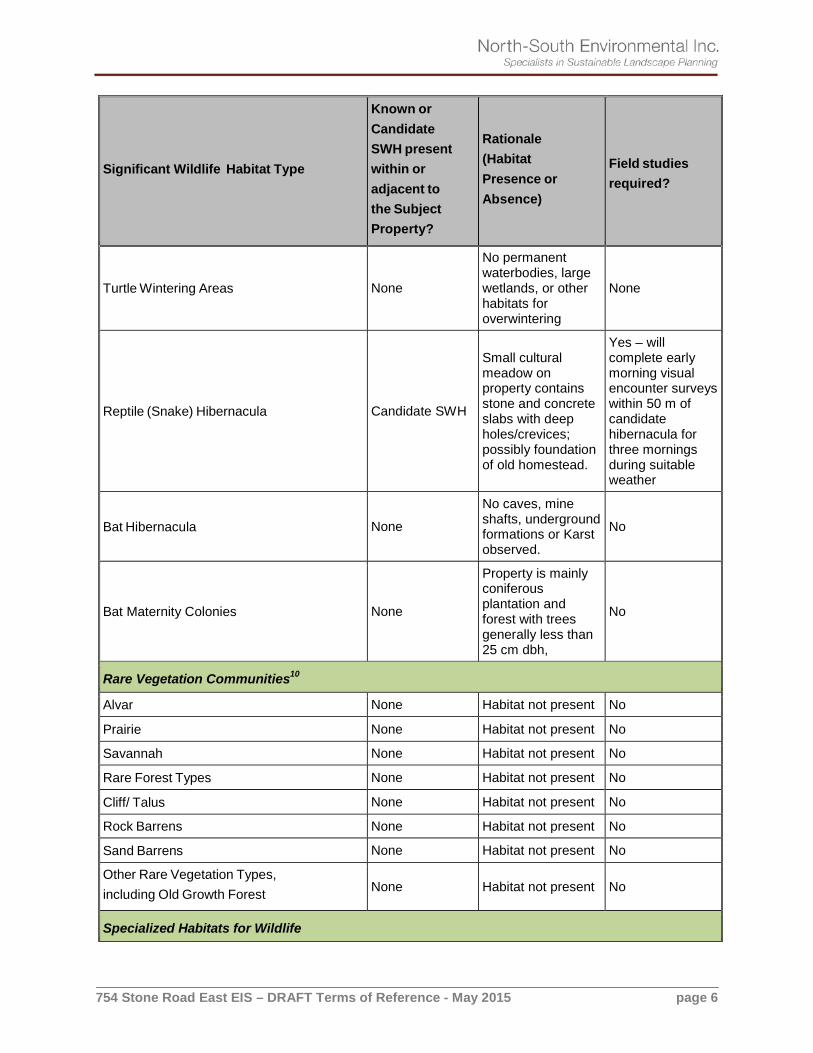
Turtle Wintering Areas None
No permanent waterbodies, large wetlands, or other habitats for overwintering
None
Reptile (Snake) Hibernacula Candidate SWH
Small cultural meadow on property contains stone and concrete slabs with deep holes/crevices; possibly foundation of old homestead.
Yes – will complete early morning visual encounter surveys within 50 m of candidate hibernacula for three mornings during suitable weather
Bat Hibernacula None
No caves, mine shafts, underground formations or Karst observed.
No
Bat Maternity Colonies None
Property is mainly coniferous plantation and forest with trees generally less than 25 cm dbh,
No
Rare Vegetation Communities10
Alvar None Habitat not present No
Prairie None Habitat not present No
Savannah None Habitat not present No
Rare Forest Types None Habitat not present No
Cliff/ Talus None Habitat not present No
Rock Barrens None Habitat not present No
Sand Barrens None Habitat not present No
Other Rare Vegetation Types, including Old Growth Forest None Habitat not present No
Specialized Habitats for Wildlife

754 Stone Road East EIS – DRAFT Terms of Reference - May 2015 page 7
Significant Wildlife Habitat Type
Known or Candidate SWH present within or adjacent to the Subject Property?
Rationale (Habitat Presence or Absence)
Field studies required?
Waterfowl Nesting Area None Habitat not present No
Bald Eagle and Osprey nesting, foraging and Perching Habitat None Habitat not present No
Woodland Raptor Nesting Habitat Candidate SWH Coniferous forest and plantation
Yes – visual search for stick nests or individuals listed in Draft Eco-region Schedule
Amphibian Breeding Habitat: • Woodland • Wetland (includes bullfrog
concentration areas)
None Habitat not present No
Turtle Nesting Habitat None Habitat not present No
Woodland/Specialized Raptor Nesting None Habitat not present No
Bald Eagle Wintering Areas None Habitat not present No
Seeps and Springs Candidate SWH Habitat may be present on slope of valley
No- proposed development is in clearing, outside of the woodland.
Wildlife Movement Corridors
Animal Movement Corridors (including Ecological Linkages11) - Deer Movement Corridors - Amphibian Movement Corridors - Other Wildlife Movement Corridors
Candidate SWH Forest in valley follows Eramosa River
No – proposed development is in clearing, outside of the woodland
Habitats of Species of Conservation Concern 12, 13

754 Stone Road East EIS – DRAFT Terms of Reference - May 2015 page 8
Significant Wildlife Habitat Type
Known or Candidate SWH present within or adjacent to the Subject Property?
Rationale (Habitat Presence or Absence)
Field studies required?
Marsh Bird Breeding Habitat None Habitat not present
No – breeding bird surveys of entire property have been completed
Woodland Area-Sensitive Breeding Habitat Candidate SWH
Woodland in valley likely contains interior forest habitat (i.e. greater than 100 m from the edge)
Yes – breeding bird survey
Open Country Bird Breeding Habitat None Habitat not present
No – breeding bird surveys of entire property have been completed
Shrub / Early Successional Breeding Bird habitat None Habitat not present
No – breeding bird surveys of entire property have been completed
Terrestrial Crayfish Habitat None Habitat not present No
Global Species of Conservation Concern (i.e., G1, G2 and G3) as identified by the NHIC14
None None listed in NHIC database No
Federal Species of Conservation Concern (i.e., listed as endangered, threatened or special concern federally)
NHIC lists Northern Map Turtle, Eastern Ribbonsnake, and Eastern Milksnake, all Special Concern
- No habitat for Northern Map Turtle - No suitable habitat for Eastern Ribbonsnake on property - There is suitable habitat for Milksnake
Yes – will complete early morning visual encounter surveys within 50 m of candidate hibernacula for three mornings during suitable weather

754 Stone Road East EIS – DRAFT Terms of Reference - May 2015 page 9
Significant Wildlife Habitat Type
Known or Candidate SWH present within or adjacent to the Subject Property?
Rationale (Habitat Presence or Absence)
Field studies required?
Provincial Species of Conservation Concern (i.e., listed as special concern provincially or S1, S2 or S3 by the NHIC)
NHIC lists Northern Map Turtle, Eastern Ribbonsnake, and Eastern Milksnake, all Special Concern
- No habitat for Northern Map Turtle - No suitable habitat for Eastern Ribbonsnake on property - There is suitable habitat for Milksnake
Yes – will complete early morning visual encounter surveys within 50 m of candidate hibernacula for three mornings during suitable weather
8The categories for Migratory Stopover Areas (for shorebirds, landbirds, butterflies and bats) have been excluded because of the distance of Guelph from the Great Lakes. 9Not specifically listed in the available guidelines, but identified by MNR in the City of Guelph 10Provincially rare communities recorded in the City of Guelph include (Dougan & Associates 2009, Guelph Natural Heritage Strategy, Phase 2: Terrestrial Inventory & Natural Heritage System, Volume 1) : Buttonbush Mineral Thicket Swamp (ELC Code: SWT2-4, NHIC Rank: S3), Silky Dogwood Mineral Thicket Swamp (ECL Code: SWT2- 8, NHIC Rank: S3/S4), White Cedar Treed Carbonate Cliff (ELC Code: CLT1-1, NHIC Rank: S3), Carbonate Open Cliff Ecosite (ELC Code: CLO1), Carbonate Shrub Cliff Ecosite (CLS1), Carbonate Treed Talus Ecosite (TAT1) 11Ecological Linkages are identified as part of the City’s Natural Heritage System and may be refined based on the applicable policies. 12Excluding species listed as Provincially Endangered or Threatened, which are addressed through the requirements of the Endangered Species Act (2007) 13In the City of Guelph, habitats for species that are locally / regionally significant, but do not qualify as Significant Wildlife Habitat or provincially Endangered or Threatened, are addressed under the policies for “Habitat for Significant Species”. 14NHIC = Natural Heritage Information Centre of Ontario 4.7 Habitat for Significant Species This section will evaluate all identified natural heritage features and areas, and associated ecological functions (in the study area, and in particularly on the subject property) and screen them against the in effect and applicable policies and guidelines to confirm whether or not they are considered “significant” in the City of Guelph. The City’s Natural Heritage Strategy provides a list of locally significant species at a County or regional level and includes both flora and fauna. All significant species will be identified and form part of the analysis regarding habitat protection for these species.

754 Stone Road East EIS – DRAFT Terms of Reference - May 2015 page 10
5.0 Data Analysis The data obtained from the field investigations and review of background studies will be evaluated in order to determine sensitivity of features and functions. The criteria for determining significant features and functions (e.g. Significant Woodlands, Significant Wildlife Habitat, etc.) will be evaluated according to the following guiding documents:
• Natural Heritage Reference Manual • Significant Wildlife Habitat Technical Guide • Draft Significant Wildlife Habitat Ecoregion 7E Criterion Schedule • City of Guelph Official Plan (consolidation September 2014) – Section 6,
Significant Natural Areas, outlines specific objectives, criteria for designation and policies for Significant Natural Areas and their buffers.
5.1 Identifying and Assessing the Impacts of the Proposal This section will identify and describe the significance of any adverse or positive environmental impacts of the subject property’s proposed use. In particular, this section will:
• describe how the proposed development could affect the natural heritage features and functions of the subject property and adjacent natural heritage features and functions
• describe direct, indirect, short-term, and long-term impacts with a particular emphasis on the following:
o tree/vegetation removal (if any) o occupancy impacts resulting from increased use by people, including
vegetation trampling, removal, litter, noise and additional invasive plant species.
5.2 Avoiding Impacts and Evaluating Alternative Mitigation
Measures Avoiding negative impacts is preferred over mitigation. Ways of avoiding impacts will be recommended. Where adverse impacts are unavoidable, a range of mitigation measures to reduce or minimize significant impacts will be recommended. The relative effectiveness of implementing these measures will be estimated and the extent of any remaining impacts discussed. This section will also include the following:
• an analysis of buffers and setbacks that are relevant to any actual/potential impacts of the subject property’s proposed use and the natural heritage features to be protected;
• a description of any proposed compensation for impacts that cannot be mitigated or restoration plans for disturbed areas;

754 Stone Road East EIS – DRAFT Terms of Reference - May 2015 page 11
• a description of other mitigation or compensation measures proposed to eliminate, reduce or off-set impacts.
5.2.1 Evaluation of Alternative Options Alternative options to avoid impacts will consider environmental constraints and sensitive habitats, seek to avoid impacts first, then minimize/mitigate impacts where avoidance is not possible. Compensate for impacts will be considered as an option where mitigation is insufficient to reduce impacts. This will be undertaken as an iterative process with the planners and other experts on the team to try and achieve a recommended plan that best achieves protection / maintenance of the NHS and still fulfills the various planning, design and servicing requirements associated with the proposed development. 6.0 Policy Review The relevant natural heritage provincial, regional, municipal and conservation authority policies and regulations will be reviewed. The proposed development plan will be assessed with respect to conformity with the relevant natural heritage policies. 7.0 Monitoring If appropriate, the EIS will include recommendations for long term management, conservation, enhancement, and/or the monitoring of significant environmental features and/or functions within the subject property and/or adjacent lands. The scope of any proposed monitoring plan and types of monitoring being proposed will be determined through assessment of features and ecological functions, sensitivity of features, and impacts resulting from the proposed development.
8.0 Conclusion The conclusion will include a summary of all recommendations emerging from the EIS, as well as whether or not there will be no negative impacts (if the recommendations are implemented), and if the proposed development conforms to the relevant environmental policies.


754 Stone Road East EIS – DRAFT Terms of Reference - May 2015 page 13
Figure 1. Air photo of subject property. Approximate property boundary illustrated in red.
Approximate property boundary
754 Stone Road EIS


754 Stone Road East EIS – DRAFT Terms of Reference - May 2015 page 15
Figure 2. Subject property as illustrated on GRCA features map.