Embed Size (px)
Citation preview

CPV Sentinel Energy Project Application for Certification 7.4 Land Use
R:\07 Sentinel\7_4.doc Page 7.4-1 June 2007
7.4 LAND USE
This section describes land use, land use designations, and zoning in the project vicinity. It also reviews adopted local plans and policies relevant to the proposed project and examines the project’s compatibility with existing land uses and zoning as well as consistency with adopted local plans and regulations. Additionally, this section describes planning actions and permits that would be required for the proposed project.
7.4.1 Affected Environment
Governmental jurisdictions within the potentially affected land use environment include Riverside County and the City of Palm Springs. The regional and local settings as well as current general plan and zoning designations are described below.
7.4.1.1 Regional Setting
Riverside County is located in southeastern California, east of the urbanized Los Angeles area. Riverside County spans from Orange County to Arizona’s border. According to the US Census Bureau, the County has a total area of 7,207 square miles (4,612,480 acres). Current land uses within the unincorporated area of the County are presented in Table 7.4-1.
A large percentage of Riverside County’s land is designated as open space and conservation. Riverside County is home to a large variety of natural resources, which include Joshua Tree National Park; portions of the Cleveland and San Bernardino National Forests; the Salton Sea; the Santa Ana, Santa Rosa, and San Jacinto Mountain Ranges; and portions of the Colorado, Santa Ana, and San Jacinto Rivers.
The County has 24 incorporated cities that include: Blythe, Banning, Beaumont, Calimes, Canyon Lake, Cathedral City, Coachella, Corona, Desert Hot Springs, Hemet, Indian Wells, Indio, LaQuinta, Lake Elsinore, Moreno Valley, Murrieta, Norco, Palm Desert, Palm Springs, Perris, Rancho Mirage, Riverside, San Jacinto, and Temecula. Of the County’s residents, 72 percent live in the incorporated cities, and 28 percent reside in the unincorporated areas (Riverside County General Plan, 2003). Riverside County had a population of 1,949,419 in 2005 (Census Bureau, 2007).
Riverside County has recently experienced rapid population growth, which is expected to continue. According to the Riverside County General Plan (2003), “The population of Riverside County and its cities is expected to double between the years 2000 and 2020, growing by approximately 1.4 million people.” This projected population increase indicates that the county will face challenges to accommodate this growth through providing the necessary infrastructure and services to the community while preserving its resources. The County realizes that growth must be managed carefully, since it wants “to preserve the unique rural character of the County and its rich open spaces” (Riverside County, 2003).
7.4.1.2 Local Setting
The power plant site, proposed electrical transmission line, as well as portions of the proposed construction laydown area and natural gas line are located within unincorporated Riverside County. The power plant site is also located within the City of Desert Hot Springs Sphere-of-Influence and just north of Palm Springs city limits. In addition, portions of the proposed construction laydown area and gas line lie within Palm Springs city limits (Figure 7.4-1).
The 37-acre power plant site consists of three separate Assessor's Parcel Numbers (APNs): 668-130-005, 668-130-007, and 668-140-001. The first two parcels and the northern portion of the third parcel encompass most of the site and are currently undeveloped. The southern portion of the third parcel (APN

CPV Sentinel Energy Project Application for Certification 7.4 Land Use
R:\07 Sentinel\7_4.doc Page 7.4-2 June 2007
668-140-001) currently contains a vacant dwelling unit, a detached garage, a domestic water well and a septic system. The parcel owners are as follows:
• APN 668-130-005; owned by D&F Land Co • APN 668-130-007; owned by Wintec Properties, LLC • APN 668-140-001; owned by D&F Land Co
The three project site parcels can be merged prior to initiating construction by filing an application for a Certificate of Parcel Merger with Riverside County Planning Department. This would occur approximately six months prior to initiating construction. The County has indicated that the parcel merger is a ministerial process that is typically approved within about one month of application submittal (Clark, 2007).
A site plan of the facility and associated features is shown on Figure 2.4-1. The power plant site is situated approximately 1.5 miles east of State Route 62 and 1.25 miles north of Interstate 10 (I-10). Primary access to the site will be from Dillon Road via State Route 62, or Indian Avenue via I-10.
Land uses adjacent to the power plant site include:
• North: Undeveloped land, and wind energy generation to the northeast. • East: Wind energy generation, and Bureau of Land Management (BLM) undeveloped
property. • South: Powerline Roads North and South, which also serve as two transmission line
corridors. • West: Undeveloped land and SCE Devers substation.
The surrounding area is primarily dominated by wind farms to the north, east, and south of the site, as well as the SCE Devers substation to the west and transmission line corridors to the south. The closest residence is located approximately 330 feet to the east of the project site. The next closest residences are located 340 feet to the south and approximately 660 feet to the east of the power plant site. Residential properties are also located approximately 2,600 feet southwest of the site. No other sensitive receptors (childcare facilities, schools, hospitals, libraries, or churches) were identified within a 2-mile radius of the proposed project site.
Existing land uses within 1 mile of the proposed project site and ¼ mile of the proposed linear right-of-ways (gas pipeline, transmission line, potable water line, access road) are depicted in Figure 7.4-1 and include: Rural to High-Density Residential, Commercial, Industrial, Public Facilities And Institutions, Transportation and Utilities, and Vacant Land. There are scattered residences located in the areas designated Estate Residential areas and Rural Desert. This figure was developed using information and land use categories provided by the Southern California Association of Governments, along with February 2007 site reconnaissance observations. Scenic corridors within the proposed project area, as designated by Riverside County, include State Route 62, I-10, and Dillon Road (Riverside County, 2003).
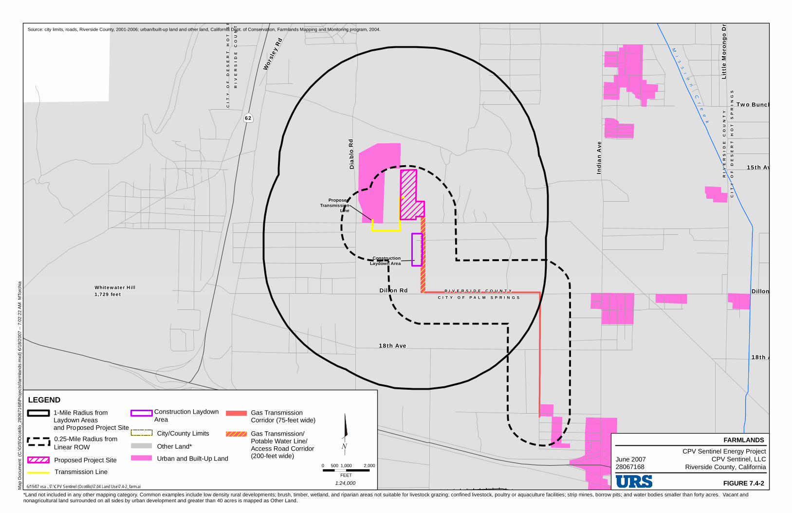
7.4.1.3 Agricultural Land
No agricultural land is within or near the project site or project linear features. According to a soil scientist with the Natural Resource Conservation Service, none of the proposed project components would involve soils that qualify as potential Prime Farmland and/or soils of Statewide Importance or Unique Farmlands. Myoma fine sand, a soil that is found within a 1-mile radius of the project site, would be considered Prime Farmland if irrigated. However, since there are no crops or irrigation systems, or any special cultivation practices, identified within a 1-mile radius of the project site or a ¼-mile radius of

CPV Sentinel Energy Project Application for Certification 7.4 Land Use
R:\07 Sentinel\7_4.doc Page 7.4-3 June 2007
the pipeline ROW, it is assumed that the Myoma fine sand located in the proposed project area is not Prime Farmland (Fahnestock, 2007).
Agricultural lands/farmlands within the study area as designated by the California Department of Conservation are shown on Figure 7.4-2. Lands within the study area include Urban and Built-up Land and Other Land. Urban and Built-up Land is defined by the California Department of Conservation as:
“land occupied by structures with a building density of at least 1 unit to 1.5 acres, or approximately 6 structures to a 10-acre parcel. This land is used for residential, industrial, commercial, construction, institutional, public administration, railroad and other transportation yards, cemeteries, airports, golf courses, sanitary landfills, sewage treatment, water control structures, and other developed purposes.”
Other Land is defined by the California Department of Conservation as:
“land not included in any other mapping category. Common examples include low density rural developments; brush, timber, wetland, and riparian areas not suitable for livestock grazing; confined livestock, poultry or aquaculture facilities; strip mines, borrow pits; and water bodies smaller than forty acres. Vacant and nonagricultural land surrounded on all sides by urban development and greater than 40 acres is mapped as Other Land” (CDC, 2007).
The proposed project and related facilities are not subject to an Agricultural Land Conservation (Williamson Act) contract. The proposed project and related facilities are located on land that is vacant and considered nonagricultural land by the California Department of Conservation.
7.4.1.4 General Plan and Zoning Designations
The Riverside County General Plan was adopted in 2003 and provides direction for the County’s development, land use, economic base, transportation system and preservation of natural and cultural resources. The following themes were used in the development of the general plan: quality of life, community identity, form and focus, choice, refining and redefining the development process, incentives, stakeholders as part of the team, and collaboration. The County General Plan outlines policies, standards, and programs to guide appropriate choices for the future of Riverside County. The General Plan and applicable land use policies are further described in Section 7.4.5.1.
The City of Palm Springs has released a draft General Plan that is expected to be adopted by the city in mid- to late 2007. The General Plan provides a vision of the future, contains an evaluation of existing conditions, and provides long-term goals and policies to guide growth and development for the next 20 years. The Palm Springs General Plan is implemented by the city through its zoning, subdivision ordinances, specific plans, growth management policies, planned development districts, development agreements, development review, code enforcement, land use database, capital improvement programs, environmental review procedures, building and housing codes, and redevelopment plans (Palm Springs, 2007). The General Plan and applicable land use policies are further described in Section 7.4.5.2.
Land uses designated in the Riverside County General Plan (2003) and the Palm Springs General Plan (2007) within 1 mile of the power plant site and ¼ mile of the proposed linear right-of-ways are depicted in Figure 7.4-3. The power plant site and proposed transmission line corridor have a land use designation of Public Facilities (PF). Additional land use designations adjacent to project features include Rural Desert, Estate Residential, Rural Residential, Industrial with Wind Energy Overlay, and Public/Utilities. The majority of the land is designated as rural desert.

CPV Sentinel Energy Project Application for Certification 7.4 Land Use
R:\07 Sentinel\7_4.doc Page 7.4-4 June 2007
The County and the City of Palm Springs zoning designations within 1 square mile of the proposed project site and ¼ square mile of the proposed linear right-of-ways are depicted in Figure 7.4-4. The power plant site is currently zoned by Riverside County as Controlled Development Area (W-2). Under Section 15.1 (e)(2), permitted uses within the W-2 district include the following:
“structures and the pertinent facilities necessary and incidental to the development and transmission of electrical power and gas such as hydroelectric power plants, booster or conversation plants, transmission lines, pipe lines and the like.”
Zoning designations for areas adjacent to project features also include General Commercial, Energy Industrial, Highway Commercial, Manufacturing, Planned Research and Development Parks, Manufacturing Service Commercial, One Family Dwelling, Rural Residential, Watercourse, Watershed And Conservation Area, Controlled Development Area, and Wind Energy Resource Area. Table 7.4-2 lists zoning designations in the study area. These designations are explained in Section 7.4.5.1 and 7.4.5.2. Palm Springs recently updated their General Plan Land Use Designations Map, therefore, their zoning designations do not currently match their general plan designations. However, Palm Springs is currently updating their City Zoning Map to correspond with the updated General Plan Land Use Designations Map (Lyon, 2007).
The Planning Departments of Riverside County, City of Palm Springs, and City of Desert Hot Springs were contacted regarding current or pending zoning changes in the area. In general, general zoning changes in the area were primarily for individual properties changing use or intensity, i.e., residential to commercial. The City of Palm Springs is currently updating the City’s General Plan. The new Draft General Plan designates the area along I-10 between Indian Avenue and Palm Canyon Avenue as Regional Business Center Land Use. This land use designation allows for industrial commercial and retail development (Lyon, 2007). In Riverside County, wind energy areas have gained prevalence in the proposed project area. Otherwise, there have been no distinguishable trends in zoning changes in the project area (Ewing, 2007; Grafton, 2007; Clark, 2007).
7.4.1.5 Recent Jurisdictional Actions
The City of Desert Hot Springs recently annexed an area (referred to by the City as “Section 36”) located approximately 16,900 feet to the northeast of the project site. This project is currently called the Oasis Annexation; it will be about 155 acres of mixed-use development. Desert Hot Springs will likely also be annexing property (referred to by the City as “Section 33”) located about 1 mile north of the project site. The City expects annexation of Section 33 to occur within the next year (Grafton, 2007).
Dillon Wind Farm is also a proposed project which includes the installation of 45 wind turbines located in three separate areas, including (1) an area west of Devers substation, (2) an area 2,000 feet east of the project site, and (3) an area 4,500 feet to the southeast of the project site. The Riverside County Planning Commission approved of this project in May 2006.
The City of Palm Springs is in the process of updating their General Plan. This update is not expected to generate new policies that would be inconsistent with the proposed CPVS project (Ewing, 2007).
Lists of discretionary reviews within the past 18 months for Riverside County (10-mile radius of the project site), City of Palm Springs, and City of Desert Hot Springs are included in Appendix L. The projects discussed below in Section 7.4.3 (cumulative impacts) further details some of the projects expected to occur in the project vicinity.
CPV Sentinel Energy Project Application for Certification 7.4 Land Use
R:\07 Sentinel\7_4.doc Page 7.4-5 June 2007
7.4.2 Environmental Consequences
7.4.2.1 Significance Criteria
The following sections discuss the effects of project construction and operation on the land use and land use resources of the project area. The relevant thresholds are identified in Appendix G of the California Environmental Quality Act (CEQA) Guidelines, listed below.
A project would have a significant impact of it would:
a) physically divide an established community; b) conflict with any applicable land use plan, policy or regulation of an agency with
jurisdiction over the project; c) conflict with any applicable habitat conservation plan or natural community conservation
plan; or d) convert Prime Farmland to non agricultural use.
Potential environmental consequences were analyzed for the study area within a one-mile radius of the proposed project site and all lands within a ¼ mile radius of the proposed linears. Potential land use impacts relate to both the construction and operation of the CPVS.
7.4.2.2 Compatibility with Established Land Uses
The proposed project is located in an area primarily dominated by wind farms and the Devers substation. One vacant dwelling unit and garage are located on the project site, and a few intermittent residences are also located near the project site, including a house located 330 feet to the east, a dwelling unit located 340 feet to the south, and a house located 660 feet to the east. The onsite dwelling unit and nearby residences are not located within residential communities. The potential relocation of these residences would not be considered dividing an established community. The nearest residential community is located approximately 2,600 feet southwest of the site; these residences would not be affected by the project.
The proposed project would not disrupt or divide an established community, nor would it conflict with the established uses of the area. The project involves the development of an industrial use in an area designated for industrial and energy-related uses. The project is compatible with the existing uses in the project area (e.g. wind energy generation and Devers substation).
7.4.2.3 Consistency with Adopted Local Goals and Policies
Table 7.4-2 lists the general plan and zoning designations for the power plant site and project features. The power plant site and proposed transmission line have a land use designation of Public Facilities (PF) in the Riverside County General Plan and are currently zoned W-2 (Controlled Development Area). Allowed uses in the land use designation include electric generating stations and permitted uses in the zoning district include structures and the pertinent facilities necessary and incidental to the development and transmission of electrical power and gas (Riverside County Municipal, 2007; Riverside County, 2003). The power plant and transmission lines are consistent with the land use and zoning designations.
Portions of the construction laydown area are designated by the County as Rural Desert (RD) and zoned as W-E (Wind Energy Resource). The storage of vehicles, machinery and materials is a permitted use in this zoning district (Riverside County Municipal, 2007; Riverside County, 2003). The remaining portions of the construction laydown area are designated by Palm Springs as Industrial (I) with a Wind Overlay and zoned as Energy Industrial (E-I). Storage of materials, machinery, trucks, and other vehicles are

CPV Sentinel Energy Project Application for Certification 7.4 Land Use
R:\07 Sentinel\7_4.doc Page 7.4-6 June 2007
permitted uses in this zoning district (Palm Springs Municipal, 2006 & Palm Springs 2007). The construction laydown area is consistent with the land use and zoning designations.
The right-of-way for the proposed access road and potable water line (as well as a portion of the proposed gas line) is designated by Riverside County as Rural Desert (RD) and Public Facilities (PF) and zoned Controlled Development Area (W2) and Wind Energy Resource (W-E). Permitted uses within these zoning districts include structures and the pertinent facilities necessary and incidental to the development and transmission of electrical power, as well as transmission facilities for electricity (Riverside County Municipal, 2007; Riverside County, 2003). The access road and potable water line (as well as the portion of the gas line) are consistent uses with the land use and zoning designations.
The remaining areas of the gas pipeline route (east of Melissa Lane) are adjacent to areas primarily designated by Palm Springs as Industrial (I) with Wind Energy Overlay and zoned Energy Industrial (E-I) and Manufacturing (M-2). The E-I zone allows energy uses with a Conditional Use Permit and industrial uses are permitted in the M-2 zoning district (Palm Springs Municipal, 2006; Palm Springs 2007). The areas of the pipeline route east of Melissa Lane within Riverside County are primarily designated as Rural Desert with an Industrial Wind Farm Overlay and Light Industrial. These areas are zoned by the County as Wind Energy Resource Zone (W-E) and Controlled Development Area (W-2). One parcel adjacent to the east of the gas line is zoned One-Family Dwelling (R-1). Installation of a gas pipeline requires a Public Use permit in the R-1 zoning district. The natural gas line is consistent with the land use and zoning designations.
The Riverside County Zoning Ordinance, Article XV W-2 Zone, stipulates 50 to 75 feet as the maximum height for structures. The eight LMS100 stacks proposed at the power plant site will be 90 feet tall each. However, height variance is subsumed within California Energy Commission (CEC) permitting process, and this is not considered a significant impact.
The proposed project is consistent with current land use and zoning designations of Riverside County and Palm Springs. No conflicts with any applicable land use plan, policy or regulation of an agency with jurisdiction over the project would occur with implementation of the proposed project.
No Prime Farmland and/or soils of Statewide Importance or Unique Farmlands are within a 1-mile radius of the project site or within ¼-mile radius of the pipeline route, therefore impacts associated with prime farmland are less than significant.
7.4.3 Cumulative Impacts
Lists of discretionary reviews within the past 18 months for Riverside County (10-mile radius of the project site), City of Palm Springs, and City of Desert Hot Springs are included in Appendix L. Projects considered under cumulative impacts include: (1) projects identified by personnel at the Riverside County Planning Department, Palm Springs Planning Department, and the Desert Hot Springs Planning Department as future projects in the area; and (2) projects which may have overlapping project impacts due to construction schedule or close proximity to the project site. The following cumulative projects are considered in further detail:
• Indian Avenue/I-10 Interchange Project: This proposed project involves reconstruction of the I-10 Freeway/Indian Avenue interchange and is located south of the proposed project. This reconstruction is expected to occur in 2008.
• Dillon Wind Farm: Installation of 45 wind turbines located in three separate areas, including (1) an area west of Devers substation, (2) an area 2,000 feet east of the project site, and (3) an area 4,500 feet to the southeast of the project site. The Environmental Impact Report for this project was recently certified by Riverside County.
CPV Sentinel Energy Project Application for Certification 7.4 Land Use
R:\07 Sentinel\7_4.doc Page 7.4-7 June 2007
• Wind Energy Conservation System (WECS) 20 Permit Project: This project would consist of 8 new GE 1.5 MW wind turbine generators in the existing WECS 20 Wind Park. This site is located approximately 0.5 mile west of State Route 62 and 2 miles north of I-10; about 2 miles northwest of the proposed project site.
• Green Path Project: The main feature of the Green Path project is a new 100-mile, 500-kV line planned to extend from the Devers-Palo Verde transmission corridor north to a new Upland substation in the northeastern sector of Los Angeles Department of Water and Power (LADWP) service territory. The project would increase the reliability and voltage support of existing system by upgrading to 230 kV standards of existing corridors. Planned construction is 2007 to 2009; planned in-service date is 2010.
• Oasis Annexation: Mixed-use development (including residential) on 155 acres located approximately 3.2 miles northeast of the project site.
• Alpine Group Development: Mixed-use development (including schools and high-density residential) on 160 acres located 1 mile northwest of the project site. The City Desert of Hot Springs is expecting to annex and approve this project.
• Palmwood Specific Plan and Outparcels Development: Mixed-use development (including 1,853 residential units) on 1,926-acres located 6.5 miles north of the site.
While land uses in the area are changing and mixed use development will be moving closer to the project site including residential and commercial properties, the area surrounding the project site will still be dominated by the Devers substation and wind farms, with the Dillon Wind Farm project further dedicating additional land to wind energy generation. The City of Desert Hot Springs is planning mixed use (including residential), as indicated in the projects identified above, in the vicinity of the proposed project. However, the proposed project is consistent with the current General Plan land use and zoning designations in the project area. Based on this consistency with future projected land uses, even in consideration of other projects in the area, the project would not have significant cumulative impacts on land uses in the area.
7.4.4 Mitigation Measures
No significant adverse land use or farmland impacts were identified; therefore, no mitigation measures are proposed.
7.4.5 Laws, Ordinances, Regulations, and Standards
LORS related to land use and their applicability to the project are summarized in Table 7.4-3 and listed below. The proposed project will be constructed and operated in compliance with all applicable land use LORS.
7.4.5.1 Riverside County
Riverside County General Plan
The Land Use Element of the General Plan contains policies that guide the future of development in the county. These policies designate and discuss the patterns and distribution of development. This element captures and communicates the County’s intentions for future use and development within the county (Riverside County, 2003).

CPV Sentinel Energy Project Application for Certification 7.4 Land Use
R:\07 Sentinel\7_4.doc Page 7.4-8 June 2007
The following General Plan land use policies apply to the land use of the proposed project:
• LU 1.3 Notify city planning departments of any discretionary projects within their respective spheres-of-influence in time to allow for coordination and to comment at public hearings.
• LU 5.4 Ensure that development and conservation land uses do not infringe upon existing public utility corridors, including fee owned rights-of-way and permanent easements, whose true land use is that of “public facilities.” This policy will ensure that the “public facilities” designation governs over what otherwise may be inferred by the large-scale general plan maps.
• LU 6.1 Require land uses to develop in accordance with the General Plan and area plans to ensure compatibility and minimize impacts.
• LU 10.2 Ensure adequate separation between pollution-producing activities and sensitive emission receptors, such as hospitals, residences, and schools.
• LU 13.1 Preserve and protect outstanding scenic vistas and visual features for the enjoyment of the traveling public.
• LU 13.4 Maintain at least a 50-foot setback from the edge of the right-of-way for new development adjacent to Designated and Eligible State and County Scenic Highways.
• LU 17.3 Ensure that development does not adversely impact the open space and rural character of the surrounding area.
Riverside County Municipal Code
This code consists of all regulatory and penal ordinances of Riverside County. The Municipal Code encompasses the Zoning Ordinance. Applicable ordinances are included in Table 7.4-3. The following County zoning designations fall within 1 square mile of the proposed project site and/or ¼ square mile of the proposed project linears. The (General Commercial (C-1/C-P)) zone is intended to promote and attract commercial development. The proposed project and associated facilities are not located within a C-1/C-P zone. The (Manufacturing Service Commercial (M-SC)) zone is intended to “promote and attract industrial and manufacturing activities which will provide jobs to local residents and strengthen the county’s economic base, provide the necessary improvements to support industrial growth, insure that new industry is compatible with uses on adjacent lands; and protect industrial areas from encroachment by incompatible uses that may jeopardize industry.” The proposed project and associated facilities are not located within an M-SC zone. The One-Family Dwelling (R-1) zone is intended to promote rural area residences and residential associated facilities. The pipeline ROW will be permitted in the R-1 zone with a Public Use Permit. The R-R (Rural Residential) zone is intended to promote rural area residences and residential associated facilities. The proposed project and associated facilities are not located within an R-R zone. The Watercourse, Watershed and Conservation Area (W-1) zone is intended to apply to lands with “a drainage and storm water control plan approved by the planning commission and the board of supervisors shall have been carried out and put into effect; or (2) the lands have been subdivided and a final subdivision map placed on record in accordance with the applicable state and county regulations.” The proposed project and associated facilities are not located within a W-1 zone. The W-2 and Controlled Development Area (W-2-5) zones apply to public utility uses where “structures and the pertinent facilities necessary and incidental to the development and transmission of electrical power.” The proposed project and associated facilities are located within a W-2 zone while none of the proposed

CPV Sentinel Energy Project Application for Certification 7.4 Land Use
R:\07 Sentinel\7_4.doc Page 7.4-9 June 2007
project and associated facilities are located within a W-2-5 zone. The Wind Energy Resource (W-E) zone allows for public utility uses and “transmission facilities for gas” (Riverside County Municipal, 2007).
Western Coachella Valley Area Plan
The proposed project site falls under the jurisdiction of the Western Coachella Valley Area Plan of Riverside County. The land use plan of this area plan “focuses on preserving the unique features in the Western Coachella Valley area and, at the same time, guides the accommodation of future growth.” The land use plan for this specific area plan has the same land use designations as the County’s General Plan.
7.4.5.2 City of Palm Springs
City of Palm Springs General Plan
The Land Use Element of the General Plan contains policies that guide the future of development in the city. This element illustrates the city’s vision of future development and land use. The following General Plan land use policies apply to the land use of the proposed project:
• Policy 1.1: Ensure that development meets or exceeds requirements and standards specified within each land use designation.
• Policy 1.5 Allow for flexible development standards provided that the potential benefits and merit of projects can be balanced with potential impacts.
City of Palm Springs Municipal Code
This code consists of all regulatory and penal ordinances of the City of Palm Springs. The Municipal Code encompasses the Zoning Ordinance. Applicable ordinances are included in Table 7.4-4. The following City zoning designations fall within 1 square mile of the proposed project site and/or ¼ square mile of the proposed pipeline right of way. The Energy Industrial (E-I) zone “is intended to provide areas for alternative energy development and limited industrial uses.” The construction laydown area is partially located within the E-I zone and is a permitted use with a Conditional Use Permit (Lyon, 2007). The Highway Commercial (H-C) zone “is intended to provide for the development of a commercial district providing for the retail and service needs of freeway travelers.” The proposed project and associated facilities are not located within the H-C zone. The (Manufacturing (M-2)) zone “is intended to provide for the development of industrial uses.” The pipeline ROW travels through the M-2 zone and is a permitted use with a Conditional Use Permit. The Planned Research and Development Parks (M-I-P) zone “is intended to provide for and encourage planned industrial districts compatible with surrounding or abutting residential zones.” The proposed project and associated facilities are not located within an M-I-P zone (Palm Springs Municipal, 2006).
7.4.5.3 Federal
There are no applicable federal land use LORS.
7.4.6 Involved Agencies and Agency Contacts
Agency contacts for agencies with jurisdiction to issue applicable permits and/or enforce LORS related to land use are provided in below.

CPV Sentinel Energy Project Application for Certification 7.4 Land Use
R:\07 Sentinel\7_4.doc Page 7.4-10 June 2007
Agency Contact Title Telephone Email City of Palm Springs Department of Planning Services
Craig Ewing Director of Planning
760-323-8269 [email protected]
Riverside County, Planning Department, Indio Office
Jay Olivas Planner 760-863-7579 [email protected]
Riverside County, Planning Department, Indio Office
Paul Clark Principal Planner 760-863-8277 [email protected]
City of Desert Hot Springs, Building, Planning, and Development Department
Jon Braginton Planner 760-329-6411 ext 258
City of Desert Hot Springs, Building, Planning, and Development Department
Larry Grafton Planner 760-329-6411 ext. 245
7.4.7 Permits Required and Permit Schedule
The California Energy Commission has exclusive authority to license power plants in California. According to Public Resources Code Section 25500:
“The issuance of a certificate by the Commission shall be in lieu of any permit, certificate or similar document required by any state, local or regional agency…and shall supersede any applicable statute, ordinance or regulation of any state, local or regional agency…”
The CEC takes into consideration the local agency requirements and permits for this type of project within each jurisdiction for AFC conditions. Agency contacts for land use-related activities are provided in Section 7.4.6. Various local agency permits that would be required, and the general schedule for obtaining permits or approvals, are discussed below. Permits and schedule are summarized below (Landerous, 2007; Kelly, 2007).
Responsible Agency Permit/Approval Schedule
California Energy Commission License power plant File AFC May 2007 (12-month process)
Riverside County Department of Building and Safety
Grading Permit
Onsite Plumbing Permit Building Permit Certificate of Occupancy
Prior to initiation of construction
Riverside County Department of Transportation
Encroachment Permit for any construction that will encroach on roadway rights-of-way
Prior to initiation of construction
City of Palm Springs Department of Building and Safety
Grading Permit
Building Permit
Prior to initiation of construction

CPV Sentinel Energy Project Application for Certification 7.4 Land Use
R:\07 Sentinel\7_4.doc Page 7.4-11 June 2007
Responsible Agency Permit/Approval Schedule
City of Palm Springs Planning Department
Conditional Use Permit for any pipeline ROW and/or energy related use that travels through M-2 zone
Conditional Use Permit for any energy related use that travels through E-I zone.
Prior to initiation of construction
City of Palm Springs Department of Public Works and Engineering
Encroachment Permit for any construction that will encroach on roadway rights-of-way
Prior to initiation of construction
7.4.8 References
Asuagbor, Della, 2007. Telephone communication with Realty Specialist, Palm Springs Field Office, Bureau of Land Management and Tammy Dorje URS Corporation. March 6, 2007.
California Energy Commission. 2000. Improvements to the Energy Commission’s Energy Facility Licensing Process. March 2000.
CDC, California Department of Conservation. 2007. Farmland Categories Definitions. Website. http://www.conservation.ca.gov/DLRP/fmmp/mccu/map_categories.htm. Accessed May 13, 2007.
Census Bureau, 2007. Riverside County Quickfacts. Website. http://quickfacts.census.gov/qfd/states/06/06065.html. February 23, 2007.
City of Palm Springs. 1993. Final Environmental Impact Report, Palm Springs Annexation Study. April.
Clark, Paul. 2007. Personal communication with Paul Clark, Riverside County Planning Department and Kathy Rushmore URS Corporation. May 18, 2007.
Desert Hot Springs, 2000. City of Desert Hot Springs General Plan. Adopted September 5, 2000.
Desert Hot Springs Municipal, 2007. City of Desert Hot Springs Municipal Code.
Desert Hot Springs Approved Projects, 2007. City of Desert Hot Springs Approved Projects. Website. http://www.desert-hot-springs.us/cityservices/building.html. May 16, 2007.
Ewing, 2007. Telephone communication with Craig Ewing, City of Palm Springs Planning Department, and Tammy Dorje, URS Corporation. April 6, 2007.
Fahnestock, Peter, 2007. Soil Scientist, Natural Resource Conservation Center Victorville Service Center. Telephone communication with Tammy Dorje of URS Corporation. March 12, 2006.
Grafton, Larry. City of Desert Hot Springs, Planning Department. May of 2007 phone interview with Kathy Rushmore, URS Corporation.

CPV Sentinel Energy Project Application for Certification 7.4 Land Use
R:\07 Sentinel\7_4.doc Page 7.4-12 June 2007
Landerous, Corinne. 2007. Telephone communication with Corinne Landerous, Riverside County Building and Safety Department and Tammy Dorje URS Corporation. May 16, 2007.
Kelly, Becky. 2007. Telephone communication with Becky Kelly, City of Palm Springs Building and Safety Department and Tammy Dorje URS Corporation. May 16, 2007.
Lyon, 2007. Telephone communication with Ken Lyon, City of Palm Springs Planning Department, and Tammy Dorje, URS Corporation. April 25, 2007, May 15, 2007, May 23, 2007.
Palm Springs Municipal, 2006. City of Palm Springs Municipal Code. December 2006.
Riverside County Municipal, 2007. Riverside County Municipal Code. February 2007.
Palm Springs Development Projects, 2007. City of Palm Springs Development Projects Update. Website. http://www.ci.palm-springs.ca.us/economic_development.html. May 16, 2007.
Palm Springs, 2007. City of Palm Springs General Plan Hearing Draft. January 2007.
Riverside County, 1985. Riverside County Comprehensive General Plan, Western Coachella Valley Plan. Adopted by the Riverside County Board of Supervisors on December 31, 1985.
Riverside County, 2003. Riverside County Comprehensive General Plan. Adopted October 7, 2003.
Rock, 2007. E-mail communication with Charles Rock, Riverside County GIS Department, and Tammy Dorje, URS Corporation. June 4, 2007.

CPV Sentinel Energy Project Application for Certification 7.4 Land Use
R:\07 Sentinel\7_4.doc Page 7.4-13 June 2007
Table 7.4-1
Unincorporated Riverside County Land Uses
Land Use Acres Agriculture 180,178
Rural 326,294
Rural Community 77,167
Open Space 3,297,992
Community Development 200,304
Other 244,800 Includes the March Inland Port, Indian Lands, and Major Roadways. Does not include cities within Riverside County. (Riverside County General Plan, 2003).
Table 7.4-2 Zoning and General Plan Designations within the Study Area
Project Component
Location General Plan Designation
Zoning Designation
Permitted Uses
Power Plant Site Riverside County Public Facilities (PF)
Controlled Development Area (W-2)
W-2–Structures and the pertinent facilities necessary and incidental to the development and transmission of electrical power.
Riverside County Rural Desert (RD)
Wind Energy Resource (W-E)
W-E–Storage of trucks and other vehicles, machinery and materials.
Construction Laydown Area
City of Palm Springs
Industrial (I)
Wind Energy Overlay
Energy Industrial (E-I)
E-I–Storage of materials, machinery, trucks, and other vehicles.
Transmission Line Interconnection
Riverside County Public Facilities (PF)
Controlled Development Area (W-2)
W-2–Structures and the pertinent facilities necessary and incidental to the development and transmission of electrical power.

CPV Sentinel Energy Project Application for Certification 7.4 Land Use
R:\07 Sentinel\7_4.doc Page 7.4-14 June 2007
Table 7.4-2 Zoning and General Plan Designations within the Study Area
Project Component
Location General Plan Designation
Zoning Designation
Permitted Uses
Riverside County Rural Desert (RD)
Public Facilities (PF)
Light Industrial (L-I)
Controlled Development Area (W-2)
Wind Energy Resource (W-E)
One-Family Dwelling (R-1)
W-2–Structures and the pertinent facilities necessary and incidental to the development and transmission of electrical power.
W-E–Transmission facilities for electricity.
R-1–Pipeline ROW will be permitted with a Public Use Permit.
Gas Transmission Corridor/Potable Water Line/Access Road
City of Palm Springs
Industrial (I)
Wind Energy Overlay
Energy Industrial (E-I)
Manufacturing (M-2)
E-I–Energy uses are permitted with a Conditional Use Permit.
M-2–Development of industrial uses that include fabrication, manufacturing, assembly or processing.

CPV Sentinel Energy Project Application for Certification 7.4 Land Use
R:\07 Sentinel\7_4.doc Page 7.4-15 June 2007
Table 7.4-3 Laws, Ordinances, Regulations, and Standards
Conformance (Section) LORS Jurisdiction Applicability
Federal None applicable.
State 7.4.5 Cal. Pub. Res. Code
§ 25523(a); 20 CCR §§ 1752, 1752.5, 2300 – 2309, and Chapter 2, Subchapter 5, Appendix B, Part (i)(3) and (4)
CEC Evaluate compatibility of the proposed project with relevant land use plans.
Local 7.4.5.2 Palm Springs Municipal
Code City of Palm Springs Planning and Zoning Department
Compliance with applicable municipal codes.
7.4.5.2 Palm Springs General Plan City of Palm Springs Planning and Zoning Department
Comply with applicable land use provisions.
7.4.5.1 Riverside County General Plan
Riverside County Planning Department
Comply with applicable land use provisions.
7.4.5.1 Riverside County Municipal Code
Riverside County Planning Department
Compliance with applicable municipal codes.
7.4.5.4 Riverside County General Plan, Land Use Element (LU-1.3)
Riverside County Planning Department
Notify city planning departments of any discretionary projects within their respective spheres-of-influence in time to allow for coordination and to comment at public hearings.

CPV Sentinel Energy Project Application for Certification 7.4 Land Use
R:\07 Sentinel\7_4.doc Page 7.4-16 June 2007
Table 7.4-3 Laws, Ordinances, Regulations, and Standards
Conformance (Section) LORS Jurisdiction Applicability
7.4.5.1 Riverside County General Plan, Land Use Element (LU-5.4)
Riverside County Planning Department
Ensure that development and conservation land uses do not infringe upon existing public utility corridors, including fee owned rights-of-way and permanent easements, whose true land use is that of “public facilities”. This policy will ensure that the “public facilities” designation governs over what otherwise may be inferred by the large scale general plan maps.
7.4.5.1 Riverside County General Plan, Land Use Element (LU-6.1)
Riverside County Planning Department
Require land uses to develop in accordance with the General Plan and area plans to ensure compatibility and minimize impacts.
7.4.1.2 Riverside County General Plan, Land Use Element (LU-10.2)
Riverside County Planning Department
Ensure adequate separation between pollution-producing activities and sensitive emission receptors, such as hospitals, residences, and schools.
7.4.1.2 Riverside County General Plan, Land Use Element (LU-13.1)
Riverside County Planning Department
Preserve and protect outstanding scenic vistas and visual features for the enjoyment of the traveling public.
7.4.1.2 Riverside County General Plan, Land Use Element (LU-13.4)
Riverside County Planning Department
Maintain at least a 50-foot setback from the edge of the right-of-way for new development adjacent to Designated and Eligible State and County Scenic Highways.
7.4.1.2 Riverside County General Plan, Land Use Element (LU-17.3)
Riverside County Planning Department
Ensure that development does not adversely impact the open space and rural character of the surrounding area.
7.4.5.1 Western Coachella Valley Area Plan
Riverside County Planning Department
Comply with applicable land use provisions.
7.4.5.1 Riverside County Municipal Code
Riverside County Building and Safety Department
Comply with all applicable county ordinances.

CPV Sentinel Energy Project Application for Certification 7.4 Land Use
R:\07 Sentinel\7_4.doc Page 7.4-17 June 2007
Table 7.4-3 Laws, Ordinances, Regulations, and Standards
Conformance (Section) LORS Jurisdiction Applicability
7.4.2.2 City of Palm Springs General Plan – Land Use Element (Policy 1.1)
City of Palm Springs Planning and Zoning Department
Ensure that development meets or exceeds requirements and standards specified within each land use designation.
7.4.2.5 City of Palm Springs General Plan – Land Use Element (Policy 1.5)
City of Palm Springs Planning and Zoning Department
Allow for flexible development standards provided that the potential benefits and merit of projects can be balanced with potential impacts.
7.4.5.2 City of Palm Springs- Zoning Code, Section 92.17.2.00
City of Palm Springs Community Preservation Department
Defines “E-I” energy industrial zone.
7.4.5.2 City of Palm Springs- Zoning Code, Section 92.17.2.01
City of Palm Springs Community Preservation Department
Defines uses permitted within the E-I Zone.
7.4.5.2 City of Palm Springs- Zoning Code, Section 92.14.1.00
City of Palm Springs Community Preservation Department
Defines “H-C” energy industrial zone.
7.4.5.2 City of Palm Springs- Zoning Code, Section 92.14.1.01
City of Palm Springs Community Preservation Department
Defines uses permitted within the H-C Zone.
7.4.5.2 City of Palm Springs- Zoning Code, Section 92.17.1.00
City of Palm Springs Community Preservation Department
Defines “M-2” energy industrial zone
7.4.5.2 City of Palm Springs- Zoning Code, Section 92.17.1.01
City of Palm Springs Community Preservation Department
Defines uses permitted within the M-2 Zone.

CPV Sentinel Energy Project Application for Certification 7.4 Land Use
R:\07 Sentinel\7_4.doc Page 7.4-18 June 2007
Table 7.4-3 Laws, Ordinances, Regulations, and Standards
Conformance (Section) LORS Jurisdiction Applicability
7.4.5.2 City of Palm Springs- Zoning Code, Section 92.16.00
City of Palm Springs Community Preservation Department
Defines “M-I-P” energy industrial zone.
7.4.5.2 City of Palm Springs- Zoning Code, Section 92.16.01
City of Palm Springs Community Preservation Department
Defines uses permitted within the M-I-P Zone.
7.4.5.1 Riverside County Municipal Code Title 17 Chapter 17.144
Riverside County Department of Building and Safety
Defines uses permitted and development standards within the W-2 Controlled Development Area Zone.
7.4.5.1 Riverside County Municipal Code Title 17 Chapter 17.164
Riverside County Department of Building and Safety
Defines uses permitted and development standards within the W-E Wind Energy Resource Zone.
7.4.5.1 Riverside County Municipal Code Title 17 Chapter 17.100
Riverside County Department of Building and Safety
Defines uses permitted and development standards within the M-SC Manufacturing Service Commercial Zone.
7.4.5.1 Riverside County Municipal Code Title 17 Chapter 17.24
Riverside County Department of Building and Safety
Defines uses permitted and development standards within the R-1 One Family Dwelling Zone.
7.4.5.1 Riverside County Municipal Code Title 17 Chapter 17.16
Riverside County Department of Building and Safety
Defines uses permitted and development standards within the R-R Rural Residential Zone.
7.4.5.1 Riverside County Municipal Code Title 17 Chapter 17.160
Riverside County Department of Building and Safety
Defines uses permitted and development standards within the W-1 Watercourse, Watershed, and Conservation Areas Zone.
7.4.5.1 Riverside County Municipal Code Title 17 Chapter 17.72
Riverside County Department of Building and Safety
Defines uses permitted and development standards within the C-1 and C-P General Commercial Zones.

C I T Y O F P A L M S P R I N G S
Two Bu
15th
Indi
anA
ve
Dillon Rd
18th Ave
Dia
blo
Rd
Wor
sley
Rd
20
Mi
ss
io
nC
re
ek
R I V E R S I D E C O U N T Y
|ÿ62
ConstructionConstructionLaydown AreaLaydown Area
ConstructionLaydown Area
CI
TY
OF
DE
SE
RT
HO
TS
PR
RI
VE
RS
ID
EC
OU
NT
Y
Powerline Rd
%&'(10
Litt
leM
oron
goD
rC
IT
YO
FD
ES
ER
TH
OT
SP
RI
NG
S
RI
VE
RS
ID
EC
OU
NT
Y
ProposedProposedTransmissionTransmission
LineLine
ProposedTransmission
Line
WindWindFarmFarmWindFarm
iWindFarm
WindFarm
WindFarm Wind
Farm
WindFarm
DeversSubstation
WhitewaterCorporation
IndigoEnergyFacility
Map
Doc
umen
t:(U
: \GI S
\ Oco
tillo
_28 0
6716
8 \Pr
o jec
ts\e
xist
ing_
land
use.
mxd
)6/1
3/20
07--
4:3 8
: 53
P MM
T orc
hia
1-Mile Radius fromLaydown Area andProposed Project Site
Proposed Project Site
Construction LaydownArea
Transmission Line0.25-Mile Radius fromLinear ROW
City/County Limits
LEGEND
Source: city limits, roads, Riverside County 2001-2006, existing land use; Southern California Association of Governments, 2005; Site Observations, February 2007.
Existing Land Use
Commercial
Industrial
Low Density Residential
Medium to High Density Residential
Public Facilities & Institutions
Rural Density Residential
Transportation & Utilities
Undeveloped/Vacant
Gas TransmissionCorridor (75-feet wide)
Gas Transmission/Potable Water Line/Access Road Corridor(200-feet wide) 0 1,000 2,000500
FEET
1:24,000
EXISTING LAND USECPV Sentinel Energy Project
CPV Sentinel, LLCRiverside County, California
FIGURE 7.4-1
June 200728067168
6/21/07 vsa/hk ..\T:\CPV Sentinel (Ocotillo)\7.04 Land Use\7.4-1_existLU.ai
C I T Y O F P A L M S P R I N G S
Two Bunch
15th Av
Dillon
Indi
anA
ve
Dillon Rd
18th AveD
iabl
oR
d
S
Wor
sley
Rd
18th A
Mi
ss
io
nC
re
ek
R I V E R S I D E C O U N T Y
|ÿ62
%&'(10
CI
TY
OF
DE
SE
RT
HO
TS
P
RI
VE
RS
ID
EC
OU
NT
Y
Litt
leM
oron
goD
rC
IT
YO
FD
ES
ER
TH
OT
SP
RI
NG
S
RI
VE
RS
ID
EC
OU
NT
Y
ConstructionLaydown Area
ProposedTransmission
Line
e
Whitewater Hill1,729 feet
Map
Doc
umen
t:(C
: \GI S
\ Oco
tillo
_28 0
6716
8 \Pr
o jec
ts\f a
r mla
nds.
mxd
)6/ 1
8 /20
0 7--
7:02
:22
AMM
T orc
hia
1-Mile Radius fromLaydown Areasand Proposed Project Site
Proposed Project Site
0.25-Mile Radius from
LEGEND
0 1,000 2,000500
FEET
Source: city limits, roads, Riverside County, 2001-2006; urban/built-up land and other land, California Dept. of Conservation, Farmlands Mapping and Monitoring program, 2004.
*Land not included in any other mapping category. Common examples include low density rural developments; brush, timber, wetland, and riparian areas not suitable for livestock grazing; confined livestock, poultry or aquaculture facilities; strip mines, borrow pits; and water bodies smaller than forty acres. Vacant andnonagricultural land surrounded on all sides by urban development and greater than 40 acres is mapped as Other Land.
1:24,000
City/County Limits
Other Land*
Urban and Built-Up Land
Gas TransmissionCorridor (75-feet wide)
Gas Transmission/Potable Water Line/Access Road Corridor(200-feet wide)
FARMLANDS
FIGURE 7.4-2
June 200728067168
CPV Sentinel Energy ProjectCPV Sentinel, LLC
Riverside County, California
6/19/07 vsa ..\T:\CPV Sentinel (Ocotillo)\7.04 Land Use\7.4-2_farm.ai
Transmission Line
Construction LaydownArea
Linear ROW

C I T Y O F P A L M S P R I N G S
Two Bunch Palms T
15th Ave
Dillon Rd
Indi
anA
ve
Dillon Rd
18th AveD
iabl
oR
d
S o u t h e r
Wor
sley
Rd
18th Ave
Mi
ss
io
nC
re
ek
R I V E R S I D E C O U N T Y
|ÿ62
ConstructionLaydown Area
CI
TY
OF
DE
SE
RT
HO
RI
VE
RS
ID
EC
O
Powerline Rd
%&'(10
Litt
leM
oro
CI
TY
OF
DE
SE
RT
HO
TS
PR
IN
GS
RI
VE
RS
ID
EC
OU
NT
Y
ProposedTransmission
Line
Map
Doc
umen
t:(U
: \GI S
\ Oco
tillo
_28 0
6716
8 \Pr
o jec
ts\g
ener
alpl
an_l
a nd u
se. m
xd)6
/18/
200 7
--7:
11:4
2PM
M.T
orch
ia
Estate Residential
Very Low DensityResidential
Light Industrial
Public Facilities
Rural Desert
Energy Industrial
General Plan Land Uses
Industrial - Wind Farm
Industrial
Wind Energy Overlay
Regional Business Center
! ! ! ! ! ! ! ! ! ! !
! ! ! ! ! ! ! ! ! ! !
! ! ! ! ! ! ! ! ! ! !
! ! ! ! ! ! ! ! ! ! !
High Density Residential
Commercial Retail
1-Mile Radius fromLaydown Areaand Proposed Project Site
Proposed Project Site
Transmission Line
0.25-Mile Radius from
LEGEND
City/County Limits
BLM Land
Gas TransmissionCorridor (75-feet wide)
Gas Transmission/Potable Water Line/Access Road Corridor(200-feet wide)
0 1,000 2,000500
FEET
1:24,000 FIGURE 7.4-3
June 200728067168
CPV Sentinel Energy ProjectCPV Sentinel, LLC
Riverside County, California
6/21/07 vsa/hk ..\T:\CPV Sentinel (Ocotillo)\7.04 Land Use\7.4-3_genplan.ai
GENERAL PLAN LAND USESLinear ROW
Construction LaydownArea
Note:The City of Palm Springs recently updated the City’s General Plan Land Use Designations Map. The City is currently updating the City Zoning Map to correspond with the revised General Plan Land Use Designations Map.

C I T Y O F P A L M S P R I N G S
Two Bun
15th
Dillo
Indi
anA
ve
Dillon Rd
18th AveD
iabl
oR
d
Wor
sley
Rd
18th
Mi
ss
io
nC
re
ek
R I V E R S I D E C O U N T Y
|ÿ62
CI
TY
OF
DE
SE
RT
HO
TS
PR
RI
VE
RS
ID
EC
OU
NT
Y
Powerline Rd
%&'(10
Litt
leM
oron
goD
rC
IT
YO
FD
ES
ER
TH
OT
SP
RI
NG
S
RI
VE
RS
ID
EC
OU
NT
Y
ProposedTransmission
Line
Map
Doc
umen
t:(U
: \GI S
\ Oco
tillo
_28 0
6716
8 \Pr
o jec
ts\z
o nin
g.m
xd)6
/ 13 /
2007
--3:
16:4
2P
MM
.To r
chi a
1-Mile Radius fromLaydown Areaand Proposed Project Site
Proposed Project Site
0.25-Mile Radius from
City/County Limits
LEGEND
BLM Land
Zoning
M-SC Manufacturing-Service Commercial
R-1 One-Family Dwelling
R-R Rural Residential
W-1 Watercourse, Watershed andConservation Area
W-2 Controlled Development Area
W-2-5 Controlled Development Area
W-E Wind Energy Resource Zone
E-I Energy Industrial
H-C Highway Commercial
M-2 Manufacturing
M-I-P Planned Reserch andDevelopment Parks
C-1/C-P General Commercial
Gas TransmissionCorridor (75-feet wide)
Gas Transmission/Potable Water Line/Access Road Corridor(200-feet wide)
ZONING
FIGURE 7.4-4
June 2007280671680 1,000 2,000500
FEET
1:24,000
CPV Sentinel Energy ProjectCPV Sentinel, LLC
Riverside County, California
6/21/07 vsa/hk ..\T:\CPV Sentinel (Ocotillo)\7.04 Land Use\7.4-4_zoning.ai
*The City of Palm Springs Zoning Map is currently being updated to correspond with the recently updated General Plan Land Use Designations Map.Source: city limits, roads, Riverside County, 2001-2006; zoning, Riverside County, 2006 and City of Palm Springs, 2003*.
Linear ROW
Construction LaydownArea
Transmission Line
ConstructionConstructionLaydown AreaLaydown Area
ConstructionLaydown Area