Embed Size (px)
Citation preview
LEA COUNTY REGIONAL WATER PLAN Water Resources Assessment
7. WATER DEMAND Water-use data and water rights information were obtained from records at the New Mexico Office of the State Engineer (NMOSE), and interviews with individual public water suppliers. NMOSE records provide the best picture of water use and water rights available, but are routinely incomplete and at times uncertain. Two NMOSE reports, entitled “Water Use by Categories in New Mexico Counties and River Basins, and Irrigated Acreage in 1995, NMOSE Technical Report 49” (Wilson, 1995) and “Lea County Underground Water Basin Annual Report 1998” (Wilson, 1998), both by Brian Wilson, were principal sources. Differences in the designated categories of water use and the way irrigation quantities are calculated between the reports are especially notable. The 1998 report is incomplete and unpublished. Therefore, recent water use data were primarily derived from the 1995 source; although1998 data were referenced when available. Wherever possible, clarifications are made in the text to identify and explain inconsistencies. Some terms important to this section of the Plan are:1
Depletion - that part of a diversion that has been evaporated, transpired, incorporated into crops, consumed by man or livestock, or otherwise removed from the water environment. It includes that portion of ground water recharge resulting from seepage or deep percolation (in connection with a water use) that is not economically recoverable in a reasonable number of years, or is not usable; Diversion - the quantity of waters taken from a ground or surface water source. A withdrawal is the same as a diversion; Diverted (set-a-side) Acreage – agricultural land in one of the production adjustment programs administered by the Agricultural Stabilization and Conservation Service; Idle and Fallow Acreage – agricultural land plowed and cultivated during the current year, but left unseeded -- or acreage that is left unused one or more years; Irrigable Acreage - the sum of irrigated acreage, diverted (set-a-side) acreage, and idle and fallow acreage. The term implies that such land is developed and that irrigation works exist to apply water. It does not include farmstead, feedlots, area in roads, and ditches, etc.; Irrigated Acreage - agricultural land to which water was artificially applied by controlled means for preplant, partial, supplemental, and semi-irrigation (inclusive) during the calendar year. Land flooded during high water periods is included as irrigation only if the water was diverted to agricultural land by dams, canals, or other works. Return Flow - the difference between diversion and depletion.
7.1 PRESENT USES 7.1.1 Type, Location, and Ownership of Water Rights TABLES 7-1 and 7-2 summarize the water rights information for Lea County listed by the NMOSE. On August 5, 1999, the LCWUA filed 138 permit applications to appropriate the remaining ground-water rights within the Lea County UWB. A total of 51,797 acre-feet of water were applied for in administrative blocks located west of Tatum, Lovington, and Hobbs. The LCWUA applied for the permits in order to take a more active role in managing
1 per Wilson (1995)
7-1
LEA COUNTY REGIONAL WATER PLAN Water Resources Assessment
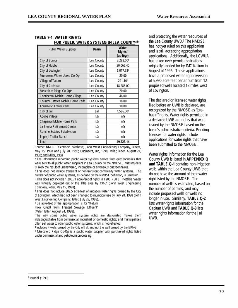
TABLE 7-1: WATER RIGHTS FOR PUBLIC WATER SYSTEMS IN LEA COUNTYa,b
Public Water Supplier Basin Water Rightsf
(ac-ft/yr) City of Eunice Lea County 3,292.00c
City of Hobbs Lea County 20,066.40 City of Lovington Lea County 6,017.58d
Monument Water Users Co-Op Lea County 80.00 Village of Tatum Lea County 291.16e
City of Carlsbad Lea County 18,288.00 Mescalero Ridge Co-Oph Lea County 20.00 Continental Mobile Home Village Lea County 46.00 Country Estates Mobile Home Park Lea County 18.00 Townsend Trailer Park Lea County 18.00 City of Jal Jal 1,586.00g
Adobe Village n/a n/a Chaparral Mobile Home Park n/a n/a La Siesta Retirement Center n/a n/a Rancho Estates Subdivision n/a n/a Triple J Trailer Ranch n/a n/a Total 49,723.14
Source: NMOSE electronic database; John West Engineering Company, letters, May 15, 1998 and July 28, 1998; Engineers, Inc, 1998; Miller, letter, August 24, 1998; and Miller, 1994 a The information regarding public water systems comes from questionnaires that were sent to all public water suppliers in Lea County by the NMOSE. Missing data is likely the result of unanswered, incomplete or erroneous questionnaires. b This does not include transient or non-transient community water systems. The number of public water systems, as defined by the NMOSE definition, is unknown. c This does not include 1,203.71 acre-feet of rights in T20S R38 E. Potable “water was virtually depleted out of this little area by 1965” (John West Engineering Company, letter, May 15, 1998). d This does not include 309.5 acre-feet of irrigation water rights owned by the City of Lovington, which had not been changed to municipal use by July 28, 1998 (John West Engineering Company, letter, July 28, 1998). e 32 acre-feet of the appropriation is for “Return Flow Credit from Treated Sewage Effluent” (Miller, letter, August 24, 1998). fThe way some public water system rights are designated makes them indistinguishable from commercial, industrial or domestic rights; and municipalities often sell water to other public water systems, which is not reflected. g includes 4 wells owned by the City of Jal, and not the well owned by the EPNG. h Mescalero Ridge Co-Op is a public water supplier with purchased rights listed under commercial and petroleum processing.
and protecting the water resources of the Lea County UWB.2 The NMOSE has not yet ruled on this application and is still accepting appropriation applications. Additionally, the LCWUA has taken over permit applications originally applied for by IMC Kalium in August of 1996. These applications have a proposed water right diversion of 5,990 acre-feet per annum from 12 proposed wells located 18 miles west of Lovington. The declared or licensed water rights, filed before an UWB is declared, are recognized by the NMOSE as “pre-basin” rights. Water rights permitted in a declared UWB are rights that were issued by the NMOSE based on the basin’s administrative criteria. Pending licenses for water rights include applications for water rights that have been submitted to the NMOSE. Water rights information for the Lea County UWB is listed in APPENDIX Q and TABLE Q-1 contains non-irrigation wells within the Lea County UWB that do not have the amount of their water right listed by the NMOSE. The number of wells is estimated, based on the number of permits, and may include proposed wells or wells no longer in use. Similarly, TABLE Q-2 lists water-rights information for the Capitan UWB and TABLE Q-3 lists water rights information for the Jal UWB.
2 Russell (1999)
7-2
LEA COUNTY REGIONAL WATER PLAN Water Resources Assessment
7.1.2 Water Rights by Category of Use
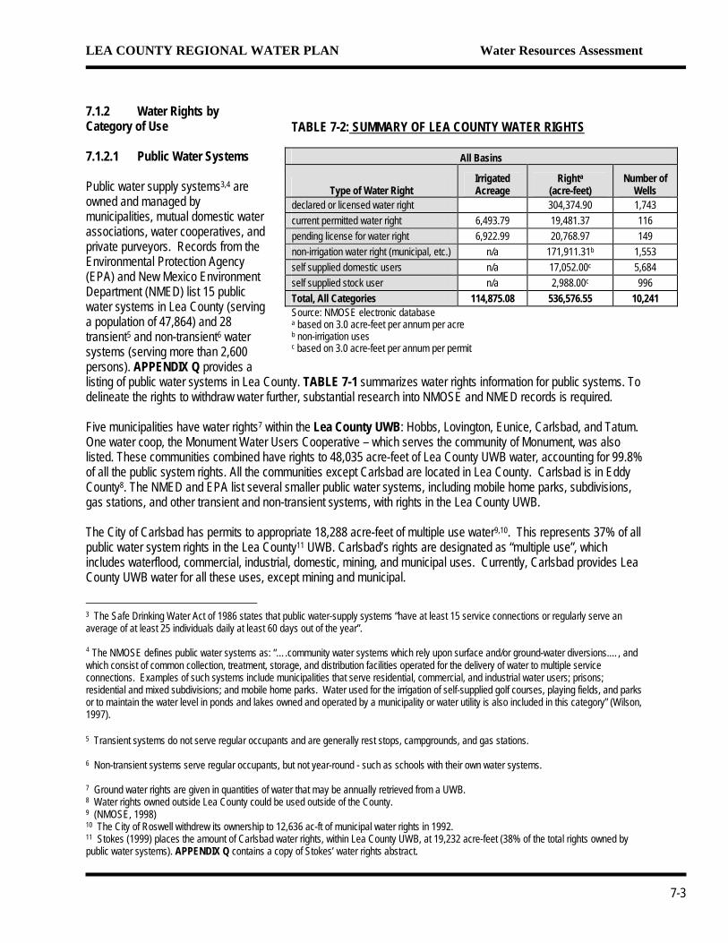
TABLE 7-2: SUMMARY OF LEA COUNTY WATER RIGHTS
All Basins
Type of Water Right Irrigated Acreage
Righta (acre-feet)
Number of Wells
declared or licensed water right 304,374.90 1,743 current permitted water right 6,493.79 19,481.37 116 pending license for water right 6,922.99 20,768.97 149 non-irrigation water right (municipal, etc.) n/a 171,911.31b 1,553 self supplied domestic users n/a 17,052.00c 5,684 self supplied stock user n/a 2,988.00c 996 Total, All Categories 114,875.08 536,576.55 10,241 Source: NMOSE electronic database a based on 3.0 acre-feet per annum per acre b non-irrigation uses c based on 3.0 acre-feet per annum per permit
7.1.2.1 Public Water Systems Public water supply systems3,4 are owned and managed by municipalities, mutual domestic water associations, water cooperatives, and private purveyors. Records from the Environmental Protection Agency (EPA) and New Mexico Environment Department (NMED) list 15 public water systems in Lea County (serving a population of 47,864) and 28 transient5 and non-transient6 water systems (serving more than 2,600 persons). APPENDIX Q provides a listing of public water systems in Lea County. TABLE 7-1 summarizes water rights information for public systems. To delineate the rights to withdraw water further, substantial research into NMOSE and NMED records is required. Five municipalities have water rights7 within the Lea County UWB: Hobbs, Lovington, Eunice, Carlsbad, and Tatum. One water coop, the Monument Water Users Cooperative – which serves the community of Monument, was also listed. These communities combined have rights to 48,035 acre-feet of Lea County UWB water, accounting for 99.8% of all the public system rights. All the communities except Carlsbad are located in Lea County. Carlsbad is in Eddy County8. The NMED and EPA list several smaller public water systems, including mobile home parks, subdivisions, gas stations, and other transient and non-transient systems, with rights in the Lea County UWB. The City of Carlsbad has permits to appropriate 18,288 acre-feet of multiple use water9,10. This represents 37% of all public water system rights in the Lea County11 UWB. Carlsbad’s rights are designated as “multiple use”, which includes waterflood, commercial, industrial, domestic, mining, and municipal uses. Currently, Carlsbad provides Lea County UWB water for all these uses, except mining and municipal.
3 The Safe Drinking Water Act of 1986 states that public water-supply systems “have at least 15 service connections or regularly serve an average of at least 25 individuals daily at least 60 days out of the year”. 4 The NMOSE defines public water systems as: “….community water systems which rely upon surface and/or ground-water diversions.…, and which consist of common collection, treatment, storage, and distribution facilities operated for the delivery of water to multiple service connections. Examples of such systems include municipalities that serve residential, commercial, and industrial water users; prisons; residential and mixed subdivisions; and mobile home parks. Water used for the irrigation of self-supplied golf courses, playing fields, and parks or to maintain the water level in ponds and lakes owned and operated by a municipality or water utility is also included in this category” (Wilson, 1997). 5 Transient systems do not serve regular occupants and are generally rest stops, campgrounds, and gas stations. 6 Non-transient systems serve regular occupants, but not year-round - such as schools with their own water systems. 7 Ground water rights are given in quantities of water that may be annually retrieved from a UWB. 8 Water rights owned outside Lea County could be used outside of the County. 9 (NMOSE, 1998) 10 The City of Roswell withdrew its ownership to 12,636 ac-ft of municipal water rights in 1992. 11 Stokes (1999) places the amount of Carlsbad water rights, within Lea County UWB, at 19,232 acre-feet (38% of the total rights owned by public water systems). APPENDIX Q contains a copy of Stokes’ water rights abstract.
7-3
LEA COUNTY REGIONAL WATER PLAN Water Resources Assessment
The City of Eunice has rights to 3,292 acre-feet of water in the Lea UWB. Eunice is the only public system to have water rights within the Lea UWB. The City of Jal has rights to 1,586 acre-feet of water in the Jal UWB. Jal is the only public system to have water rights in the Jal UWB. 7.1.2.2 Domestic Domestic uses include “self-supplied residences, which may be single family homes or multiple housing units with less than 25 occupants, where water is used for normal household purposes such as drinking, food preparation, bathing, washing clothes and dishes, flushing toilets, and watering lawns and gardens.”12 This use “also includes water used by that segment of the population that is served by small community water systems for which reliable population and water use data are unavailable”.13 Public water systems, listed by the NMED and EPA, that are not recognized by the NMOSE would be included in this category because the NMOSE does not have reliable population or water use data for them. Domestic wells are permitted to use up to 3 acre-feet per year for non-commercial uses. There are 5,421 domestic well permits in the Lea County UWB, 261 in the Capitan UWB, and 2 in the Jal UWB. Correspondingly, there are 16,263 acre-feet of domestic water rights in the Lea County UWB, 783 acre-feet Capitan UWB, and 6 acre-feet in the Jal UWB. TABLE Q-4 lists the location of domestic water rights in the Lea County UWB. The locations of domestic water rights in the Capitan UWB are listed in TABLE Q-5. 7.1.2.3 Irrigated Agriculture NMOSE has records for 1,946 well permits with irrigation acreage and 987 well permits without acreage, in the Lea County UWB. The water rights for the wells with acreage total 113,400 acres or 340,202 acre-feet, assuming the application of 3.0 acre-feet per acre14. Similarly, the Capitan UWB has 61 permitted wells for 1,475 acres or 4,424 acre-feet. There are no irrigation wells permitted in the Jal UWB. There are 2,007 irrigation wells in all of Lea County, corresponding to 114,876 acres or 344,625 acre-feet. In contrast, the 1995 irrigable acreage15 in all of Lea County was 83,500 acres and the actual acreage irrigated was only 51,345 acres; the total withdrawal was 131,163 acre-feet. TABLE Q-6 lists irrigation wells that do not have an approved acreage appropriation. There is a distinction between the amount of water allocated to an irrigation water right and the amount the NMOSE considers to have been used by that right. An irrigation water right entitles an owner to use up to three acre-feet of water per acre. The NMOSE estimates the amount of water actually applied by an empirical method (see APPENDIX R). Allocated water rights do not change, unless they are reallocated. Periodic NMOSE estimates of actual water use vary with changes in crop type, cropping patterns, type of irrigation, and recent weather patterns—to name a few. Irrigation water rights are summarized on lines 1, 2, and 3 of TABLES 7-3 for the individual UWBs in Lea County and for Lea County as a whole, respectively.
12 Wilson (1992) 13 Wilson (1992) 14 The Lea County UWB Annual Reports use 3.0 acre-feet per acre for the approved appropriation for irrigation 15 Irrigable acreage is the land area available for crop planting, with basic irrigation infrastructure available. These areas are ready for agricultural use, but do not necessarily support active farming.
7-4
LEA COUNTY REGIONAL WATER PLAN Water Resources Assessment
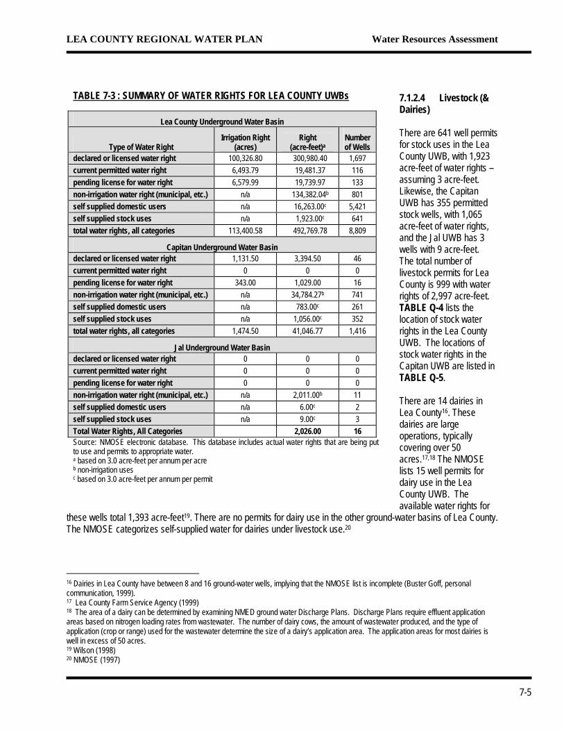
TABLE 7-3 : SUMMARY OF WATER RIGHTS FOR LEA COUNTY UWBs
Lea County Underground Water Basin
Type of Water Right Irrigation Right
(acres) Right
(acre-feet)aNumber of Wells
declared or licensed water right 100,326.80 300,980.40 1,697 current permitted water right 6,493.79 19,481.37 116 pending license for water right 6,579.99 19,739.97 133 non-irrigation water right (municipal, etc.) n/a 134,382.04b 801 self supplied domestic users n/a 16,263.00c 5,421 self supplied stock uses n/a 1,923.00c 641 total water rights, all categories 113,400.58 492,769.78 8,809
Capitan Underground Water Basin declared or licensed water right 1,131.50 3,394.50 46 current permitted water right 0 0 0 pending license for water right 343.00 1,029.00 16 non-irrigation water right (municipal, etc.) n/a 34,784.27b 741 self supplied domestic users n/a 783.00c 261 self supplied stock uses n/a 1,056.00c 352 total water rights, all categories 1,474.50 41,046.77 1,416
Jal Underground Water Basin declared or licensed water right 0 0 0 current permitted water right 0 0 0 pending license for water right 0 0 0 non-irrigation water right (municipal, etc.) n/a 2,011.00b 11 self supplied domestic users n/a 6.00c 2 self supplied stock uses n/a 9.00c 3 Total Water Rights, All Categories 2,026.00 16 Source: NMOSE electronic database. This database includes actual water rights that are being put to use and permits to appropriate water. a based on 3.0 acre-feet per annum per acre b non-irrigation uses c based on 3.0 acre-feet per annum per permit
7.1.2.4 Livestock (& Dairies) There are 641 well permits for stock uses in the Lea County UWB, with 1,923 acre-feet of water rights – assuming 3 acre-feet. Likewise, the Capitan UWB has 355 permitted stock wells, with 1,065 acre-feet of water rights, and the Jal UWB has 3 wells with 9 acre-feet. The total number of livestock permits for Lea County is 999 with water rights of 2,997 acre-feet. TABLE Q-4 lists the location of stock water rights in the Lea County UWB. The locations of stock water rights in the Capitan UWB are listed in TABLE Q-5. There are 14 dairies in Lea County16. These dairies are large operations, typically covering over 50 acres.17,18 The NMOSE lists 15 well permits for dairy use in the Lea County UWB. The available water rights for
these wells total 1,393 acre-feet19. There are no permits for dairy use in the other ground-water basins of Lea County. The NMOSE categorizes self-supplied water for dairies under livestock use.20
16 Dairies in Lea County have between 8 and 16 ground-water wells, implying that the NMOSE list is incomplete (Buster Goff, personal communication, 1999). 17 Lea County Farm Service Agency (1999) 18 The area of a dairy can be determined by examining NMED ground water Discharge Plans. Discharge Plans require effluent application areas based on nitrogen loading rates from wastewater. The number of dairy cows, the amount of wastewater produced, and the type of application (crop or range) used for the wastewater determine the size of a dairy’s application area. The application areas for most dairies is well in excess of 50 acres. 19 Wilson (1998) 20 NMOSE (1997)
7-5
LEA COUNTY REGIONAL WATER PLAN Water Resources Assessment
7.1.2.5 Commercial There are 123 well permits for commercial use in the Lea County UWB. The water rights for these wells total 1,066.57 acre-feet. There are 109 well permits for commercial use in the Capitan UWB, with water rights of 6,158.43 acre-feet. There are two commercial well permits in the Jal UWB, with 35 acre-feet. The entire Lea County has a 234 well permits for commercial use with water rights of 7,260 ac-ft per annum. 7.1.2.6 Industrial There are 42 well permits for industrial uses in the Lea County UWB. The NMOSE does not list a water right quantity for each permit. The listed water rights exceed 4,950 acre-feet. There are 14 well permits for Industrial uses in the Capitan UWB, with water rights totaling 4,808.80 acre-feet. There are 3 well permits for industrial uses in the Jal UWB, with water rights totaling 390 acre-feet. There are 6 well permits for industrial uses located in unspecified basin(s); these unspecified water rights total 734 acre-feet. The entire Lea County has a total of 65 well permits for Industrial uses with water rights of in excess of 10,882.8 acre-feet. 7.1.2.7 Mining Mining uses include secondary recovery of oil, oil well drilling, ore mining, and petroleum processing. There are 1,891 well permits for mining uses in the Lea County UWB. The approved appropriation for each well permit was not available, however, their combined permitted water rights total 59,707.95 acre-feet. There are only 56 well permits in the Lea County UWB listed for mining use; the remaining 1,835 wells are used for petroleum industry activities. Six mining companies have water rights within the Lea County UWB. All the companies are involved in the mining of potash. The appropriated water for mining wells totals 25,299 acre-feet21 in the Lea County UWB; the appropriated water for petroleum wells totals 34,408.95 acre-feet.22 The Capitan UWB has 274 well permits for mining use, with water rights totaling 23,817.04 acre-feet. Of these 274 well permits, only 3 are actually used for mining; the remaining permits are for petroleum production. The 3 mining permits have water rights of 2,855 acre-feet and are owned by two potash mining companies. The Jal UWB has one mining well permit for a well that supplies a petroleum processing plant.23 All of Lea County has approximately 2,165 mining use well permits with at least 83,525 acre-feet of water rights. Fifty-nine of the 2,165 well permits are for potash mining and have water rights totaling 28,154 acre-feet. 7.1.2.8 Power All 79 of the Lea County wells, permitted for power generation, are within the Lea County UWB. The total permitted water rights for these wells are 20,520.38 acre-feet. 7.1.3 Water Diversions by Category of Use
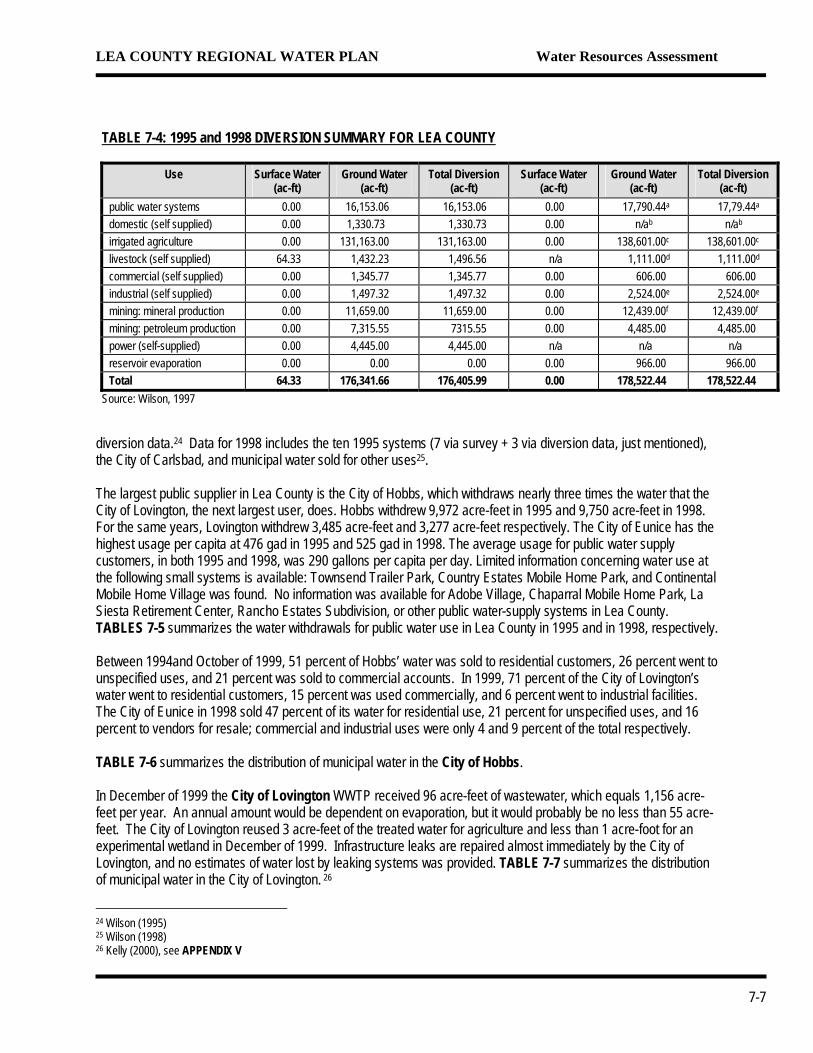
TABLE 7-4 summarizes the water withdrawals associated with all water diversions in Lea County in 1995 and 1998. 7.1.3.1 Public Water Supply Seven public water-supply systems, with service populations ranging from 53 to over 29,500, responded to a 1995 survey conducted by the NMOSE. Information on three additional public suppliers is listed in the 1995 NMOSE
21 Their total approved appropriation, according to Wilson (1998) is 22,619 acre-feet, a figure similar to that listed by the NMOSE. 22 Wilson (1998) states the approved appropriation for secondary oil recovery is 27,606 acre-feet. This includes some commercial sales, but does not include water use from the Capitan or Jal UWBs. 23 The well is listed under industrial use instead of mining use.
7-6
LEA COUNTY REGIONAL WATER PLAN Water Resources Assessment
TABLE 7-4: 1995 and 1998 DIVERSION SUMMARY FOR LEA COUNTY
Use Surface Water (ac-ft)
Ground Water (ac-ft)
Total Diversion (ac-ft)
Surface Water (ac-ft)
Ground Water (ac-ft)
Total Diversion (ac-ft)
public water systems 0.00 16,153.06 16,153.06 0.00 17,790.44a 17,79.44a
domestic (self supplied) 0.00 1,330.73 1,330.73 0.00 n/ab n/ab
irrigated agriculture 0.00 131,163.00 131,163.00 0.00 138,601.00c 138,601.00c
livestock (self supplied) 64.33 1,432.23 1,496.56 n/a 1,111.00d 1,111.00d
commercial (self supplied) 0.00 1,345.77 1,345.77 0.00 606.00 606.00 industrial (self supplied) 0.00 1,497.32 1,497.32 0.00 2,524.00e 2,524.00e
mining: mineral production 0.00 11,659.00 11,659.00 0.00 12,439.00f 12,439.00f
mining: petroleum production 0.00 7,315.55 7315.55 0.00 4,485.00 4,485.00 power (self-supplied) 0.00 4,445.00 4,445.00 n/a n/a n/a reservoir evaporation 0.00 0.00 0.00 0.00 966.00 966.00 Total 64.33 176,341.66 176,405.99 0.00 178,522.44 178,522.44
Source: Wilson, 1997
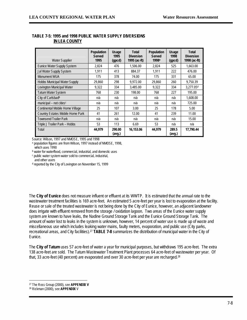
diversion data.24 Data for 1998 includes the ten 1995 systems (7 via survey + 3 via diversion data, just mentioned), the City of Carlsbad, and municipal water sold for other uses25. The largest public supplier in Lea County is the City of Hobbs, which withdraws nearly three times the water that the City of Lovington, the next largest user, does. Hobbs withdrew 9,972 acre-feet in 1995 and 9,750 acre-feet in 1998. For the same years, Lovington withdrew 3,485 acre-feet and 3,277 acre-feet respectively. The City of Eunice has the highest usage per capita at 476 gad in 1995 and 525 gad in 1998. The average usage for public water supply customers, in both 1995 and 1998, was 290 gallons per capita per day. Limited information concerning water use at the following small systems is available: Townsend Trailer Park, Country Estates Mobile Home Park, and Continental Mobile Home Village was found. No information was available for Adobe Village, Chaparral Mobile Home Park, La Siesta Retirement Center, Rancho Estates Subdivision, or other public water-supply systems in Lea County. TABLES 7-5 summarizes the water withdrawals for public water use in Lea County in 1995 and in 1998, respectively. Between 1994and October of 1999, 51 percent of Hobbs’ water was sold to residential customers, 26 percent went to unspecified uses, and 21 percent was sold to commercial accounts. In 1999, 71 percent of the City of Lovington’s water went to residential customers, 15 percent was used commercially, and 6 percent went to industrial facilities. The City of Eunice in 1998 sold 47 percent of its water for residential use, 21 percent for unspecified uses, and 16 percent to vendors for resale; commercial and industrial uses were only 4 and 9 percent of the total respectively. TABLE 7-6 summarizes the distribution of municipal water in the City of Hobbs. In December of 1999 the City of Lovington WWTP received 96 acre-feet of wastewater, which equals 1,156 acre-feet per year. An annual amount would be dependent on evaporation, but it would probably be no less than 55 acre-feet. The City of Lovington reused 3 acre-feet of the treated water for agriculture and less than 1 acre-foot for an experimental wetland in December of 1999. Infrastructure leaks are repaired almost immediately by the City of Lovington, and no estimates of water lost by leaking systems was provided. TABLE 7-7 summarizes the distribution of municipal water in the City of Lovington. 26
24 Wilson (1995) 25 Wilson (1998) 26 Kelly (2000), see APPENDIX V
7-7
LEA COUNTY REGIONAL WATER PLAN Water Resources Assessment
TABLE 7-5: 1995 and 1998 PUBLIC WATER SUPPLY DIVERSIONS IN LEA COUNTY
Water Supplier
Population Served 1995
Usage 1995
(gpcd)
Total Diversion
1995 (ac-ft)
Population Served 1998a
Usage 1998
(gpcd)
Total Diversion
1998 (ac-ft) Eunice Water Supply System 2,824 476 1,506.00 2,824 525 1,663.00 Jal Water Supply System 1,911 413 884.37 1,911 222 476.00 Monument WUA 175 378 74.00 175 331 65.00 Hobbs Municipal Water Supply 29,860 298 9,972.00 29,860 260 9,750.39 Lovington Municipal Water 9,322 334 3,485.00 9,322 334 3,277.05d
Tatum Water System 768 230 198.00 768 227 195.00 City of Carlsbadb n/a n/a n/a n/a n/a 1,608.00 municipal – not citiesc n/a n/a n/a n/a n/a 725.00 Continental Mobile Home Village 25 107 3.00 25 178 5.00 Country Estates Mobile Home Park 41 261 12.00 41 239 11.00 Townsend Trailer Park n/a n/a n/a n/a n/a 15.00 Triple J Trailer Park – Hobbs 53 113 6.69 53 n/a n/a Total 44,979 290.00
(avg.) 16,153.06 44,979 289.5
(avg.) 17,790.44
Source: Wilson, 1997 and NMOSE, 1995 and 1998 a population figures are from Wilson, 1997 instead of NMOSE, 1998, which uses 1990 b water for waterflood, commercial, industrial, and domestic uses c public water system water sold to commercial, industrial, and other users d reported by the City of Lovington on November 15, 1999
The City of Eunice does not measure influent or effluent at its WWTP. It is estimated that the annual rate to the wastewater treatment facilities is 169 acre-feet. An estimated 5 acre-feet per year is lost to evaporation at the facility. Reuse or sale of the treated wastewater is not being done by the City of Eunice, however, an adjacent landowner does irrigate with effluent removed from the storage / oxidation lagoon. Two areas of the Eunice water supply system are known to have leaks, the Nadine Ground Storage Tank and the Eunice Ground Storage Tank. The amount of water lost to leaks in the system is unknown, however, 14 percent of water use is made up of waste and miscellaneous use which includes leaking water mains, faulty meters, evaporation, and public use (City parks, recreational areas, and City facilities).27 TABLE 7-8 summarizes the distribution of municipal water in the City of Eunice.
The City of Tatum uses 57 acre-feet of water a year for municipal purposes, but withdraws 195 acre-feet. The extra 138 acre-feet are sold. The Tatum Wastewater Treatment Plant processes 64 acre-feet of wastewater per year. Of that, 33 acre-feet (40 percent) are evaporated and over 30 acre-feet per year are recharged.28
27 The Ross Group (2000), see APPENDIX V 28 Rickman (2000), see APPENDIX V
7-8
LEA COUNTY REGIONAL WATER PLAN Water Resources Assessment
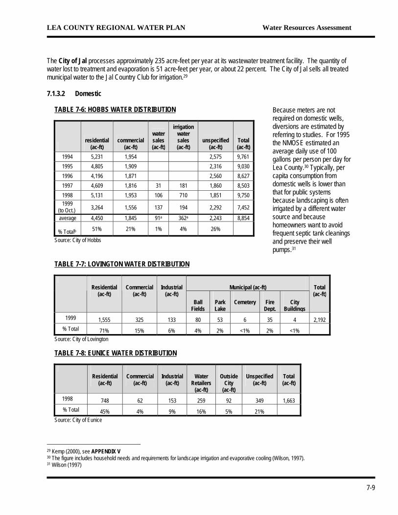
The City of Jal processes approximately 235 acre-feet per year at its wastewater treatment facility. The quantity of water lost to treatment and evaporation is 51 acre-feet per year, or about 22 percent. The City of Jal sells all treated municipal water to the Jal Country Club for irrigation.29
7.1.3.2 Domestic
TABLE 7-7: LOVINGTON WATER DISTRIBUTION
Municipal (ac-ft)
Residential (ac-ft)
Commercial (ac-ft)
Industrial (ac-ft)
Ball Fields
Park Lake
Cemetery Fire Dept.
City Buildings
Total (ac-ft)
1999 1,555 325 133 80 53 6 35 4 2,192 % Total 71% 15% 6% 4% 2% <1% 2% <1%
Source: City of Lovington
TABLE 7-8: EUNICE WATER DISTRIBUTION
Residential
(ac-ft) Commercial
(ac-ft) Industrial
(ac-ft) Water
Retailers (ac-ft)
Outside City
(ac-ft)
Unspecified (ac-ft)
Total (ac-ft)
1998 748 62 153 259 92 349 1,663 % Total 45% 4% 9% 16% 5% 21%
Source: City of Eunice
TABLE 7-6: HOBBS WATER DISTRIBUTION
residential
(ac-ft) commercial
(ac-ft)
water sales (ac-ft)
irrigation water sales (ac-ft)
unspecified (ac-ft)
Total (ac-ft)
1994 5,231
Because meters are not required on domestic wells, diversions are estimated by referring to studies. For 1995 the NMOSE estimated an average daily use of 100 gallons per person per day for Lea County.30 Typically, per capita consumption from domestic wells is lower than that for public systems because landscaping is often irrigated by a different water source and because homeowners want to avoid frequent septic tank cleanings and preserve their well pumps.31
1,954 2,575 9,761 1995 4,805 1,909 2,316 9,030 1996 4,196 1,871 2,560 8,627 1997 4,609 1,816 31 181 1,860 8,503 1998 5,131 1,953 106 710 1,851 9,750 1999 (to Oct.) 3,264 1,556 137 194 2,292 7,452
average 4,450 1,845 91a 362a 2,243 8,854 % Totalb 51% 21% 1% 4% 26%
Source: City of Hobbs
29 Kemp (2000), see APPENDIX V 30 The figure includes household needs and requirements for landscape irrigation and evaporative cooling (Wilson, 1997). 31 Wilson (1997)
7-9
LEA COUNTY REGIONAL WATER PLAN Water Resources Assessment
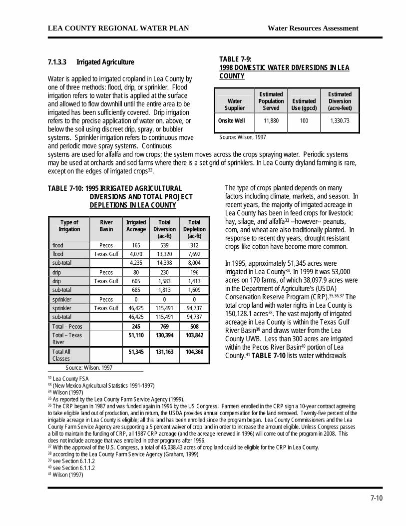
TABLE 7-9: 1998 DOMESTIC WATER DIVERSIONS IN LEA COUNTY
Water Supplier
Estimated Population
Served Estimated Use (gpcd)
Estimated Diversion (acre-feet)
Onsite Well 11,880 100 1,330.73
Source: Wilson, 1997
7.1.3.3 Irrigated Agriculture Water is applied to irrigated cropland in Lea County by one of three methods: flood, drip, or sprinkler. Flood irrigation refers to water that is applied at the surface and allowed to flow downhill until the entire area to be irrigated has been sufficiently covered. Drip irrigation refers to the precise application of water on, above, or below the soil using discreet drip, spray, or bubbler systems. Sprinkler irrigation refers to continuous move and periodic move spray systems. Continuous systems are used for alfalfa and row crops; the system moves across the crops spraying water. Periodic systems may be used at orchards and sod farms where there is a set grid of sprinklers. In Lea County dryland farming is rare, except on the edges of irrigated crops32.
The type of crops planted depends on many factors including climate, markets, and season. In recent years, the majority of irrigated acreage in Lea County has been in feed crops for livestock: hay, silage, and alfalfa33 --however-- peanuts, corn, and wheat are also traditionally planted. In response to recent dry years, drought resistant crops like cotton have become more common. In 1995, approximately 51,345 acres were irrigated in Lea County34. In 1999 it was 53,000 acres on 170 farms, of which 38,097.9 acres were in the Department of Agriculture’s (USDA) Conservation Reserve Program (CRP).35, ,36 37 The total crop land with water rights in Lea County is 150,128.1 acres38. The vast majority of irrigated acreage in Lea County is within the Texas Gulf River Basin39 and draws water from the Lea County UWB. Less than 300 acres are irrigated within the Pecos River Basin40 portion of Lea County.41 TABLE 7-10 lists water withdrawals
TABLE 7-10: 1995 IRRIGATED AGRICULTURAL DIVERSIONS AND TOTAL PROJECT DEPLETIONS IN LEA COUNTY
Type of
Irrigation River Basin
Irrigated Acreage
Total Diversion
(ac-ft)
Total Depletion
(ac-ft) flood Pecos 165 539 312 flood Texas Gulf 4,070 13,320 7,692 sub-total 4,235 14,398 8,004 drip Pecos 80 230 196 drip Texas Gulf 605 1,583 1,413 sub-total 685 1,813 1,609 sprinkler Pecos 0 0 0 sprinkler Texas Gulf 46,425 115,491 94,737 sub-total 46,425 115,491 94,737 Total – Pecos 245 769 508 Total – Texas River
51,110 130,394 103,842
Total All Classes
51,345 131,163 104,360
Source: Wilson, 1997
32 Lea County FSA 33 (New Mexico Agricultural Statistics 1991-1997) 34 Wilson (1997) 35 As reported by the Lea County Farm Service Agency (1999). 36 The CRP began in 1987 and was funded again in 1996 by the US Congress. Farmers enrolled in the CRP sign a 10-year contract agreeing to take eligible land out of production, and in return, the USDA provides annual compensation for the land removed. Twenty-five percent of the irrigable acreage in Lea County is eligible; all this land has been enrolled since the program began. Lea County Commissioners and the Lea County Farm Service Agency are supporting a 5 percent waiver of crop land in order to increase the amount eligible. Unless Congress passes a bill to maintain the funding of CRP, all 1987 CRP acreage (and the acreage renewed in 1996) will come out of the program in 2008. This does not include acreage that was enrolled in other programs after 1996. 37 With the approval of the U.S. Congress, a total of 45,038.43 acres of crop land could be eligible for the CRP in Lea County. 38 according to the Lea County Farm Service Agency (Graham, 1999) 39 see Section 6.1.1.2 40 see Section 6.1.1.2 41 Wilson (1997)7-10
LEA COUNTY REGIONAL WATER PLAN Water Resources Assessment
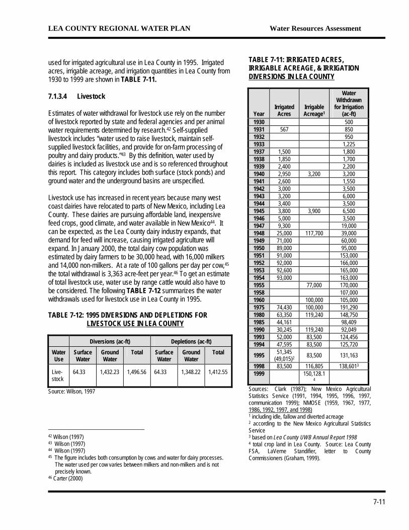
used for irrigated agricultural use in Lea County in 1995. Irrigated acres, irrigable acreage, and irrigation quantities in Lea County from 1930 to 1999 are shown in TABLE 7-11. 7.1.3.4 Livestock Estimates of water withdrawal for livestock use rely on the number of livestock reported by state and federal agencies and per animal water requirements determined by research.42 Self-supplied livestock includes “water used to raise livestock, maintain self-supplied livestock facilities, and provide for on-farm processing of poultry and dairy products.”43 By this definition, water used by dairies is included as livestock use and is so referenced throughout this report. This category includes both surface (stock ponds) and ground water and the underground basins are unspecified. Livestock use has increased in recent years because many west coast dairies have relocated to parts of New Mexico, including Lea County. These dairies are pursuing affordable land, inexpensive feed crops, good climate, and water available in New Mexico44. It can be expected, as the Lea County dairy industry expands, that demand for feed will increase, causing irrigated agriculture will expand. In January 2000, the total dairy cow population was estimated by dairy farmers to be 30,000 head, with 16,000 milkers and 14,000 non-milkers. At a rate of 100 gallons per day per cow,45 the total withdrawal is 3,363 acre-feet per year.46 To get an estimate of total livestock use, water use by range cattle would also have to be considered. The following TABLE 7-12 summarizes the water withdrawals used for livestock use in Lea County in 1995.
TABLE 7-12: 1995 DIVERSIONS AND DEPLETIONS FOR LIVESTOCK USE IN LEA COUNTY
Diversions (ac-ft) Depletions (ac-ft)
Water Use
Surface Water
Ground Water
Total Surface Water
Ground Water
Total
Live-stock
64.33 1,432.23 1,496.56 64.33 1,348.22 1,412.55
Source: Wilson, 1997
42 Wilson (1997) 43 Wilson (1997) 44 Wilson (1997) 45 The figure includes both consumption by cows and water for dairy processes. The water used per cow varies between milkers and non-milkers and is not precisely known. 46 Carter (2000)
TABLE 7-11: IRRIGATED ACRES, IRRIGABLE ACREAGE, & IRRIGATION DIVERSIONS IN LEA COUNTY
Year Irrigated
Acres Irrigable Acreage1
Water Withdrawn
for Irrigation (ac-ft)
1930 500 1931 567 850 1932 950 1933 1,225 1937 1,500 1,800 1938 1,850 1,700 1939 2,400 2,200 1940 2,950 3,200 3,200 1941 2,600 1,550 1942 3,000 3,500 1943 3,200 6,000 1944 3,400 3,500 1945 3,800 3,900 6,500 1946 5,000 3,500 1947 9,300 19,000 1948 25,000 117,700 39,000 1949 71,000 60,000 1950 89,000 95,000 1951 91,000 153,000 1952 92,000 166,000 1953 92,600 165,000 1954 93,000 163,000 1955 77,000 170,000 1958 107,000 1960 100,000 105,000 1975 74,430 100,000 191,290 1980 63,350 119,240 148,750 1985 44,161 98,409 1990 30,245 119,240 92,049 1993 52,000 83,500 124,456 1994 47,595 83,500 125,720
1995 51,345 (49,015)2 83,500 131,163
1998 83,500 116,805 138,6013
1999 150,128.14
Sources: Clark (1987); New Mexico Agricultural Statistics Service (1991, 1994, 1995, 1996, 1997, communication 1999); NMOSE (1959, 1967, 1977, 1986, 1992, 1997, and 1998)1 including idle, fallow and diverted acreage 2 according to the New Mexico Agricultural Statistics Service 3 based on Lea County UWB Annual Report 1998 4 total crop land in Lea County. Source: Lea County FSA, LaVerne Standifier, letter to County Commissioners (Graham, 1999).
7-11
LEA COUNTY REGIONAL WATER PLAN Water Resources Assessment
TABLE 7-13: PLAYA LAKE &
STOCKPOND EVAPORATION DEPLETIONS IN LEA COUNTY
Year
Playa Lake Evaporation (acre-feet)
Stockpond Evaporation (acre-feet)
1975 8,900 137 1980 n/aa 279
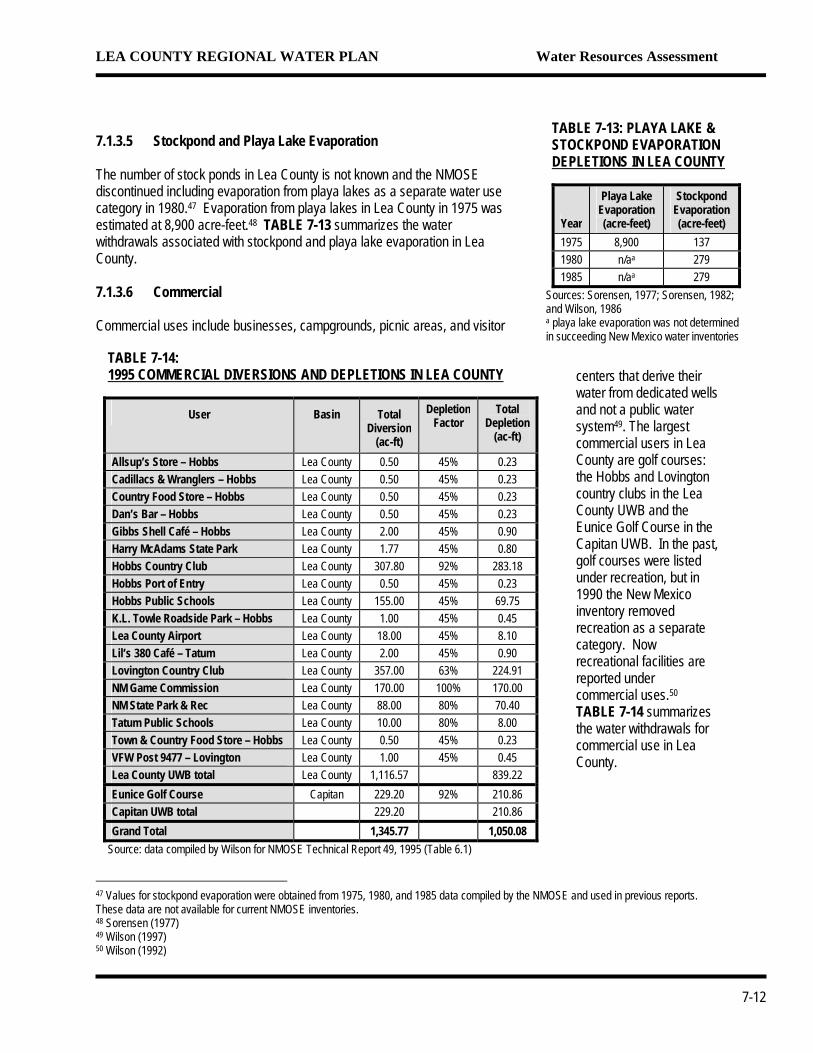
7.1.3.5 Stockpond and Playa Lake Evaporation The number of stock ponds in Lea County is not known and the NMOSE discontinued including evaporation from playa lakes as a separate water use category in 1980.47 Evaporation from playa lakes in Lea County in 1975 was estimated at 8,900 acre-feet.48 TABLE 7-13 summarizes the water withdrawals associated with stockpond and playa lake evaporation in Lea County. 1985 n/aa 279
Sources: Sorensen, 1977; Sorensen, 1982; and Wilson, 1986 a playa lake evaporation was not determined in succeeding New Mexico water inventories
7.1.3.6 Commercial
TABLE 7-14: 1995 COMMERCIAL DIVERSIONS AND DEPLETIONS IN LEA COUNTY
User Basin Total Diversion
(ac-ft)
Depletion Factor
Total Depletion
(ac-ft)
Allsup’s Store – Hobbs Lea County 0.50 45% 0.23 Cadillacs & Wranglers – Hobbs Lea County 0.50 45% 0.23 Country Food Store – Hobbs Lea County 0.50 45% 0.23 Dan’s Bar – Hobbs Lea County 0.50 45% 0.23 Gibbs Shell Café – Hobbs Lea County 2.00 45% 0.90 Harry McAdams State Park Lea County 1.77 45% 0.80 Hobbs Country Club Lea County 307.80 92% 283.18 Hobbs Port of Entry Lea County 0.50 45% 0.23 Hobbs Public Schools Lea County 155.00 45% 69.75 K.L. Towle Roadside Park – Hobbs Lea County 1.00 45% 0.45 Lea County Airport Lea County 18.00 45% 8.10 Lil’s 380 Café – Tatum Lea County 2.00 45% 0.90 Lovington Country Club Lea County 357.00 63% 224.91 NM Game Commission Lea County 170.00 100% 170.00 NM State Park & Rec Lea County 88.00 80% 70.40 Tatum Public Schools Lea County 10.00 80% 8.00 Town & Country Food Store – Hobbs Lea County 0.50 45% 0.23 VFW Post 9477 – Lovington Lea County 1.00 45% 0.45 Lea County UWB total Lea County 1,116.57 839.22 Eunice Golf Course Capitan 229.20 92% 210.86 Capitan UWB total 229.20 210.86 Grand Total 1,345.77 1,050.08
Source: data compiled by Wilson for NMOSE Technical Report 49, 1995 (Table 6.1)
Commercial uses include businesses, campgrounds, picnic areas, and visitor
centers that derive their water from dedicated wells and not a public water system49. The largest commercial users in Lea County are golf courses: the Hobbs and Lovington country clubs in the Lea County UWB and the Eunice Golf Course in the Capitan UWB. In the past, golf courses were listed under recreation, but in 1990 the New Mexico inventory removed recreation as a separate category. Now recreational facilities are reported under commercial uses.50 TABLE 7-14 summarizes the water withdrawals for commercial use in Lea County.
47 Values for stockpond evaporation were obtained from 1975, 1980, and 1985 data compiled by the NMOSE and used in previous reports. These data are not available for current NMOSE inventories. 48 Sorensen (1977) 49 Wilson (1997) 50 Wilson (1992)
7-12
LEA COUNTY REGIONAL WATER PLAN Water Resources Assessment
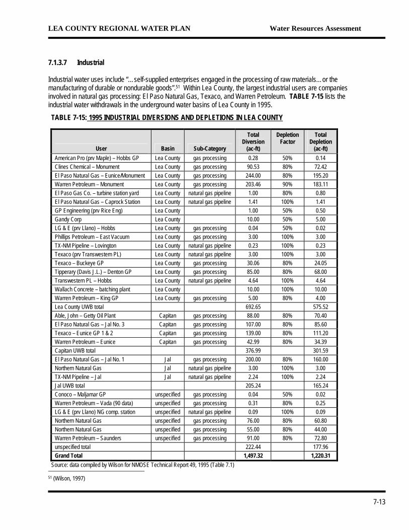
7.1.3.7 Industrial Industrial water uses include “…self-supplied enterprises engaged in the processing of raw materials…or the manufacturing of durable or nondurable goods”.51 Within Lea County, the largest industrial users are companies involved in natural gas processing: El Paso Natural Gas, Texaco, and Warren Petroleum. TABLE 7-15 lists the industrial water withdrawals in the underground water basins of Lea County in 1995.
TABLE 7-15: 1995 INDUSTRIAL DIVERSIONS AND DEPLETIONS IN LEA COUNTY
User Basin Sub-Category
Total Diversion
(ac-ft)
Depletion Factor
Total Depletion
(ac-ft) American Pro (prv Maple) – Hobbs GP Lea County gas processing 0.28 50% 0.14 Clines Chemical – Monument Lea County gas processing 90.53 80% 72.42 El Paso Natural Gas – Eunice/Monument Lea County gas processing 244.00 80% 195.20 Warren Petroleum – Monument Lea County gas processing 203.46 90% 183.11 El Paso Gas Co. – turbine station yard Lea County natural gas pipeline 1.00 80% 0.80 El Paso Natural Gas – Caprock Station Lea County natural gas pipeline 1.41 100% 1.41 GP Engineering (prv Rice Eng) Lea County 1.00 50% 0.50 Gandy Corp Lea County 10.00 50% 5.00 LG & E (prv Llano) – Hobbs Lea County gas processing 0.04 50% 0.02 Phillips Petroleum – East Vacuum Lea County gas processing 3.00 100% 3.00 TX-NM Pipeline – Lovington Lea County natural gas pipeline 0.23 100% 0.23 Texaco (prv Transwestern PL) Lea County natural gas pipeline 3.00 100% 3.00 Texaco – Buckeye GP Lea County gas processing 30.06 80% 24.05 Tipperary (Davis J.L.) – Denton GP Lea County gas processing 85.00 80% 68.00 Transwestern PL – Hobbs Lea County natural gas pipeline 4.64 100% 4.64 Wallach Concrete – batching plant Lea County 10.00 100% 10.00 Warren Petroleum – King GP Lea County gas processing 5.00 80% 4.00 Lea County UWB total 692.65 575.52 Able, John – Getty Oil Plant Capitan gas processing 88.00 80% 70.40 El Paso Natural Gas – Jal No. 3 Capitan gas processing 107.00 80% 85.60 Texaco – Eunice GP 1 & 2 Capitan gas processing 139.00 80% 111.20 Warren Petroleum – Eunice Capitan gas processing 42.99 80% 34.39 Capitan UWB total 376.99 301.59 El Paso Natural Gas – Jal No. 1 Jal gas processing 200.00 80% 160.00 Northern Natural Gas Jal natural gas pipeline 3.00 100% 3.00 TX-NM Pipeline – Jal Jal natural gas pipeline 2.24 100% 2.24 Jal UWB total 205.24 165.24 Conoco – Maljamar GP unspecified gas processing 0.04 50% 0.02 Warren Petroleum – Vada (90 data) unspecified gas processing 0.31 80% 0.25 LG & E (prv Llano) NG comp. station unspecified natural gas pipeline 0.09 100% 0.09 Northern Natural Gas unspecified gas processing 76.00 80% 60.80 Northern Natural Gas unspecified gas processing 55.00 80% 44.00 Warren Petroleum – Saunders unspecified gas processing 91.00 80% 72.80 unspecified total 222.44 177.96 Grand Total 1,497.32 1,220.31
Source: data compiled by Wilson for NMOSE Technical Report 49, 1995 (Table 7.1) 51 (Wilson, 1997)
7-13
LEA COUNTY REGIONAL WATER PLAN Water Resources Assessment
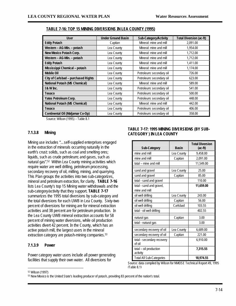
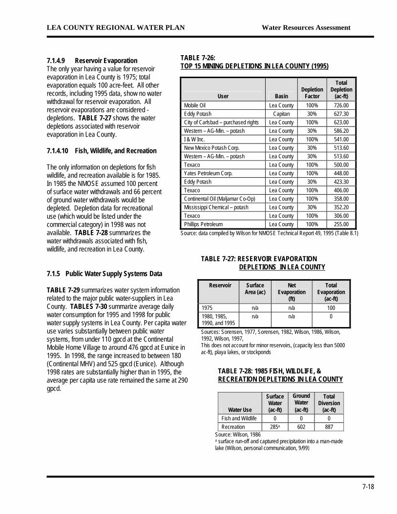
TABLE 7-16: TOP 15 MINING DIVERSIONS IN LEA COUNTY (1995)
User Under Ground Basin Sub-Category/Activity Total Diversion (ac-ft)
Eddy Potash Capitan Mineral: mine and mill 2,091.00 Western – AG-Min. – potash Lea County Mineral: mine and mill 1,954.00 New Mexico Potash Corp. Lea County Mineral: mine and mill 1,712.00 Western – AG-Min. – potash Lea County Mineral: mine and mill 1,712.00 Eddy Potash Lea County Mineral: mine and mill 1,411.00 Mississippi Chemical – potash Lea County Mineral: mine and mill 1,174.00 Mobile Oil Lea County Petroleum: secondary oil 726.00 City of Carlsbad – purchased Rights Lea County Petroleum: secondary oil 623.00 National Potash (MS Chemical) Lea County Mineral: mine and mill 589.00 I & W Inc. Lea County Petroleum: secondary oil 541.00 Texaco Lea County Petroleum: secondary oil 500.00 Yates Petroleum Corp. Lea County Petroleum: secondary oil 448.00 National Potash (MS Chemical) Lea County Mineral: mine and mill 442.00 Texaco Lea County Petroleum: secondary oil 406.00 Continental Oil (Maljamar Co-Op) Lea County Petroleum: secondary oil 358.00 Source: Wilson (1995) – Table 8.1
7.1.3.8 Mining Mining use includes “…self-supplied enterprises engaged in the extraction of minerals occurring naturally in the earth’s crust: solids, such as coal and smelting ores; liquids, such as crude petroleum; and gases, such as natural gas”.52 Within Lea County mining activities which require water are well drilling, petroleum processing, secondary recovery of oil, milling, mining, and quarrying. This Plan groups the activities into two sub-categorizes, mineral and petroleum extraction, for clarity. TABLE 7-16 lists Lea County’s top 15 Mining water withdrawals and the sub-category/activity that they support. TABLE 7-17 summarizes the 1995 total diversions by sub-category and the total diversions for each UWB in Lea County. Sixty-two percent of diversions for mining are for mineral extraction activities and 38 percent are for petroleum production. In the Lea County UWB mineral extraction accounts for 58 percent of mining water diversions, while oil production activities divert 42 percent. In the County, which has an active potash mill, the largest users in the mineral extraction category are potash-mining companies.53 7.1.3.9 Power Power category water users include all power generating facilities that supply their own water. All diversions for
52 Wilson (1997) 53 New Mexico is the United State’s leading producer of potash, providing 83 p
TABLE 7-17: 1995 MINING DIVERSIONS (BY SUB-CATEGORY ) IN LEA COUNTY
Sub-Category Basin Total Diversion
(ac-ft) mine and mill Lea County 9,458.00 mine and mill Capitan 2,091.00 total – mine and mill 11,549.00 sand and gravel Lea County 25.00 sand and gravel Capitan 85.00 total - sand and gravel 110.00 total - sand and gravel, mine and mill
11,659.00
oil well drilling Lea County 243.00 oil well drilling Capitan 56.00 oil well drilling Carlsbad 103.55 total - oil well drilling 402.55 natural gas Capitan 3.00 total - natural gas 3.00 secondary recovery of oil Lea County 6,689.00 secondary recovery of oil Capitan 221.00 total - secondary recovery of oil
6,910.00
total – oil production activity
7,315.55
Total All Sub-Categories 18,974.55 Source: data compiled by Wilson for NMOSE Technical Report 49, 1995 (Table 8.1)
ercent of the nation’s total.
7-14
LEA COUNTY REGIONAL WATER PLAN Water Resources Assessment
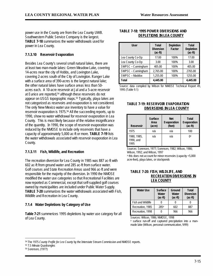
power use in the County are from the Lea County UWB. Southwestern Public Service Company is the largest. TABLE 7-18 summarizes the water withdrawals used for power in Lea County. 7.1.3.10 Reservoir Evaporation Besides Lea County’s several small natural lakes, there are at least two man-made lakes: Green Meadow Lake, covering 14-acres near the city of Hobbs, and Lovington Lake, covering 2-acres south of the City of Lovington. Ranger Lake with a surface area of 390-acres is the largest natural lake; the other natural lakes have surface areas less than 50-acres each. A 10-acre reservoir at Jal and a 5-acre reservoir at Eunice are reported,54 although these reservoirs do not appear on USGS topographic maps.55 Typically, playa lakes are not categorized as reservoirs and evaporation is not considered. The only New Mexico water use inventory to have a value for reservoir evaporation is 1975.56 All the succeeding reports, up to 1990, show no water withdrawal for reservoir evaporation in Lea County. This is most likely because of the relative insignificance of the quantity. In 1990, the scope of reservoir evaporation was reduced by the NMOSE to include only reservoirs that have a capacity of approximately 5,000 ac-ft or more. TABLE 7-19 lists the water withdrawals associated with reservoir evaporation in LeaCounty. 7.1.3.11 Fish, Wildlife, and Recreation The recreation diversion for Lea County in 1985 was 887 ac-ft with602 ac-ft from ground water and 285 ac-ft from surface water. Golf courses and State Recreation Areas used 966 ac-ft and were responsible for the majority of the diversion. In 1990 the NMOSE modified the water use categories so that Recreational Facilities arnow reported as Commercial, except that self-supplied golf coursesowned by municipalities are included under Public Water Supply. TABLE 7-20 summarizes the water withdrawals associated with FiWildlife and Recreation in Lea County. 7.1.4 Water Depletions by Category of Use Table 7-21 summerizes 1995 depletions by water use category forof Lea County.
54 The 1975 County Profile for Lea County by the Interstate Stream Commission a55 7.5 Minute Quadrangles 56 Sorensen, (1977)
TABLE 7-18: 1995 POWER DIVERSIONS AND DEPLETIONS IN LEA COUNTY
User Total
Diversion (ac-ft)
DepletionFactor
Tolal Depletion
(ac-ft) Lea County Co-Op 17.00 100% 17.00 Lea County Co-Op 3.00 100% 3.00 SWPSC – Cunningham 405.00 100% 405.00 SWPSC – Cunningham 2,765.00 100% 2765.00 SWPSC – Maddox 1,255.00 100% 1255.00 Total 4,445.00 4,445.00
Source: data compiled by Wilson for NMOSE Technical Report 49, 1995 (Table 9.1)
TABLE 7-19: RESERVOIR EVAPORATION DIVERSIONS IN LEA COUNTY
Reservoir
Surface Area (acre)
Net Evaporation
(feet)
Total Evaporation
(ac-ft) 1975 n/a n/a 100 1980, 1985, 1990, and 1995
n/a n/a 0a
Sources: Sorensen, 1977; Sorensen, 1982; Wilson, 1986; Wilson, 1992; and Wilson, 1997 a this does not account for minor reservoirs (capacity <5,000 acre-feet), playa lakes, or stockponds
e
sh,
TABLE 7-20: FISH, WILDLIFE, AND RECREATION DIVERSIONS IN LEA COUNTY
Water Use Surface
Water (ac-ft)
Ground Water (ac-ft)
Total Diversion
(ac-ft) Fish and Wildlife 0 0 0 Recreation, 1985 285a 602 887 Recreation, 1998 0 966 966
Sources: Wilson, 1986; NMOSE, 1998 a surface run-off and captured precipitation into a man-made lake (Wilson, personal communication, 9/99)
all
nd NMOSE reports.
7-15
LEA COUNTY REGIONAL WATER PLAN Water Resources Assessment
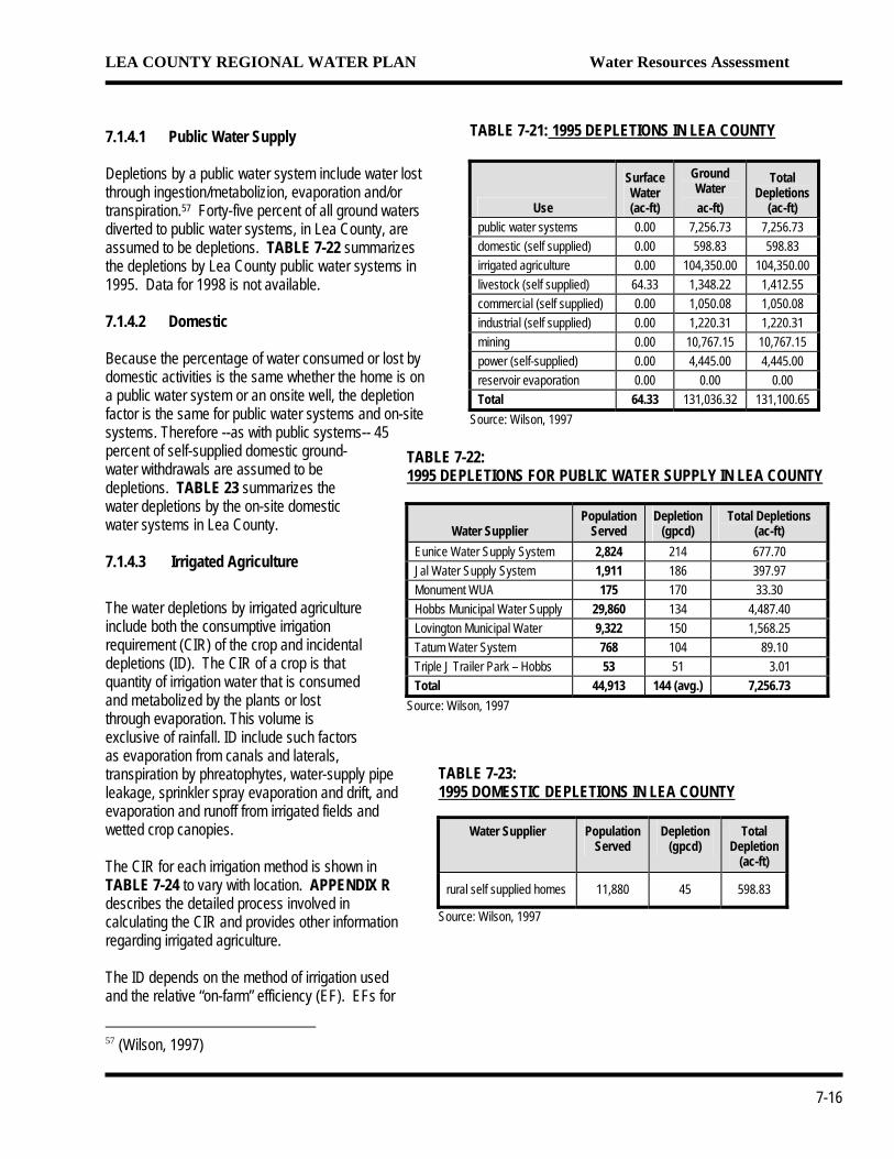
7.1.4.1 Public Water Supply Depletions by a public water system include water lost through ingestion/metabolizion, evaporation and/or transpiration.57 Forty-five percent of all ground waters diverted to public water systems, in Lea County, are assumed to be depletions. TABLE 7-22 summarizes the depletions by Lea County public water systems in 1995. Data for 1998 is not available. 7.1.4.2 Domestic
TABLE 71995 DEP
WEunice WJal Water MonumenHobbs MuLovingtonTatum WaTriple J TrTotal
Source: Wil
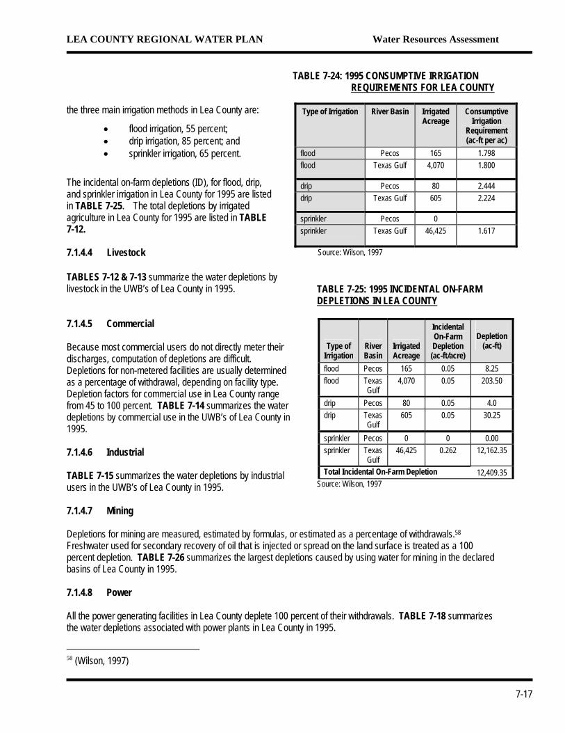
Because the percentage of water consumed or lost by domestic activities is the same whether the home is on a public water system or an onsite well, the depletion factor is the same for public water systems and on-site systems. Therefore --as with public systems-- 45 percent of self-supplied domestic ground-water withdrawals are assumed to be depletions. TABLE 23 summarizes the water depletions by the on-site domestic water systems in Lea County. 7.1.4.3 Irrigated Agriculture The water depletions by irrigated agriculture include both the consumptive irrigation requirement (CIR) of the crop and incidental depletions (ID). The CIR of a crop is that quantity of irrigation water that is consumed and metabolized by the plants or lost through evaporation. This volume is exclusive of rainfall. ID include such factors as evaporation from canals and laterals, transpiration by phreatophytes, water-supply pipe leakage, sprinkler spray evaporation and drift, and evaporation and runoff from irrigated fields and wetted crop canopies.
TAB1995
rura
Sour
The CIR for each irrigation method is shown in TABLE 7-24 to vary with location. APPENDIX R describes the detailed process involved in calculating the CIR and provides other information regarding irrigated agriculture. The ID depends on the method of irrigation used and the relative “on-farm” efficiency (EF). EFs for
57 (Wilson, 1997)
TABLE 7-21: 1995 DEPLETIONS IN LEA COUNTY
Use
Surface Water (ac-ft)
Ground Water ac-ft)
Total Depletions
(ac-ft) public water systems 0.00 7,256.73 7,256.73 domestic (self supplied) 0.00 598.83 598.83 irrigated agriculture 0.00 104,350.00 104,350.00 livestock (self supplied) 64.33 1,348.22 1,412.55 commercial (self supplied) 0.00 1,050.08 1,050.08 industrial (self supplied) 0.00 1,220.31 1,220.31 mining 0.00 10,767.15 10,767.15 power (self-supplied) 0.00 4,445.00 4,445.00 reservoir evaporation 0.00 0.00 0.00 Total 64.33 131,036.32 131,100.65
Source: Wilson, 1997
-22: LETIONS FOR PUBLIC WATER SUPPLY IN LEA COUNTY
ater Supplier Population
Served Depletion
(gpcd) Total Depletions
(ac-ft) ater Supply System 2,824 214 677.70 Supply System 1,911 186 397.97 t WUA 175 170 33.30 nicipal Water Supply 29,860 134 4,487.40 Municipal Water 9,322 150 1,568.25 ter System 768 104 89.10 ailer Park – Hobbs 53 51 3.01
44,913 144 (avg.) 7,256.73 son, 1997
LE 7-23: DOMESTIC DEPLETIONS IN LEA COUNTY
Water Supplier Population Served
Depletion (gpcd)
Total Depletion
(ac-ft)
l self supplied homes 11,880 45 598.83
ce: Wilson, 1997
7-16
LEA COUNTY REGIONAL WATER PLAN Water Resources Assessment
t he three main irrigation methods in Lea County are:
• flood irrigation, 55 percent; • drip irrigation, 85 percent; and • sprinkler irrigation, 65 percent.
The incidental on-farm depletions (ID), for flood, drip, and sprinkler irrigation in Lea County for 1995 are listed in TABLE 7-25. The total depletions by irrigated agriculture in Lea County for 1995 are listed in TABLE 7-12. 7.1.4.4 Livestock TABLES 7-12 & 7-13 summarize the water depletions by livestock in the UWB’s of Lea County in 1995.
7.1.4.5 Commercial Because most commercial users do not directly meter their discharges, computation of depletions are difficult. Depletions for non-metered facilities are usually determined as a percentage of withdrawal, depending on facility type. Depletion factors for commercial use in Lea County range from 45 to 100 percent. TABLE 7-14 summarizes the water depletions by commercial use in the UWB’s of Lea County in 1995. 7.1.4.6 Industrial TABLE 7-15 summarizes the water depletions by industrial users in the UWB’s of Lea County in 1995. 7.1.4.7 Mining Depletions for mining are measured, estimated by formulas, or estiFreshwater used for secondary recovery of oil that is injected or sppercent depletion. TABLE 7-26 summarizes the largest depletionsbasins of Lea County in 1995. 7.1.4.8 Power All the power generating facilities in Lea County deplete 100 percenthe water depletions associated with power plants in Lea County in
58 (Wilson, 1997)
TABLE 7-25: 1995 INCIDENTAL ON-FARM DEPLETIONS IN LEA COUNTY
Type of Irrigation
River Basin
Irrigated Acreage
Incidental On-Farm Depletion (ac-ft/acre)
Depletion (ac-ft)
flood Pecos 165 0.05 8.25 flood Texas
Gulf 4,070 0.05 203.50
drip Pecos 80 0.05 4.0 drip Texas
Gulf 605 0.05 30.25
sprinkler Pecos 0 0 0.00 sprinkler Texas
Gulf 46,425 0.262 12,162.35
Total Incidental On-Farm Depletion 12,409.35 Source: Wilson, 1997
TABLE 7-24: 1995 CONSUMPTIVE IRRIGATION REQUIREMENTS FOR LEA COUNTY
Type of Irrigation River Basin Irrigated
Acreage Consumptive
Irrigation Requirement (ac-ft per ac)
flood Pecos 165 1.798 flood Texas Gulf 4,070 1.800
drip Pecos 80 2.444 drip Texas Gulf 605 2.224
sprinkler Pecos 0 sprinkler Texas Gulf 46,425 1.617
Source: Wilson, 1997
mated as a percentage of withdrawals.58 read on the land surface is treated as a 100 caused by using water for mining in the declared
t of their withdrawals. TABLE 7-18 summarizes 1995.
7-17
LEA COUNTY REGIONAL WATER PLAN Water Resources Assessment
TABLE 7-26: TOP 15 MINING DEPLETIONS IN LEA COUNTY (1995)
User Basin Depletion
Factor
Total Depletion
(ac-ft) Mobile Oil Lea County 100% 726.00 Eddy Potash Capitan 30% 627.30 City of Carlsbad – purchased rights Lea County 100% 623.00
7.1.4.9 Reservoir Evaporation The only year having a value for reservoir evaporation in Lea County is 1975; total evaporation equals 100 acre-feet. All other records, including 1995 data, show no water withdrawal for reservoir evaporation. All reservoir evaporations are considered -depletions. TABLE 7-27 shows the water depletions associated with reservoir evaporation in Lea County. Western – AG-Min. – potash Lea County 30% 586.20
I & W Inc. Lea County 100% 541.00 New Mexico Potash Corp. Lea County
30% 513.60
Western – AG-Min. – potash Lea County 30% 513.60 Texaco Lea County 100% 500.00 Yates Petroleum Corp. Lea County 100% 448.00 Eddy Potash Lea County 30% 423.30 Texaco Lea County 100% 406.00 Continental Oil (Maljamar Co-Op) Lea County 100% 358.00 Mississippi Chemical – potash Lea County 30% 352.20 Texaco Lea County 100% 306.00 Phillips Petroleum Lea County 100% 255.00
Source: data compiled by Wilson for NMOSE Technical Report 49, 1995 (Table 8.1)
7.1.4.10 Fish, Wildlife, and Recreation The only information on depletions for fish wildlife, and recreation available is for 1985. In 1985 the NMOSE assumed 100 percent of surface water withdrawals and 66 percent of ground water withdrawals would be depleted. Depletion data for recreational use (which would be listed under the commercial category) in 1998 was not available. TABLE 7-28 summarizes the water withdrawals associated with fish, wildlife, and recreation in Lea County. TABLE 7-27: RESERVOIR EVAPORATION
DEPLETIONS IN LEA COUNTY
Reservoir Surface Area (ac)
Net Evaporation
(ft)
Total Evaporation
(ac-ft) 1975 n/a n/a 100 1980, 1985, 1990, and 1995
n/a n/a 0
Sources: Sorensen, 1977, Sorensen, 1982, Wilson, 1986, Wilson, 1992, Wilson, 1997, This does not account for minor reservoirs, (capacity less than 5000 ac-ft), playa lakes, or stockponds
7.1.5 Public Water Supply Systems Data TABLE 7-29 summarizes water system information related to the major public water-suppliers in Lea County. TABLES 7-30 summarize average daily water consumption for 1995 and 1998 for public water supply systems in Lea County. Per capita water use varies substantially between public water systems, from under 110 gpcd at the Continental Mobile Home Village to around 476 gpcd at Eunice in 1995. In 1998, the range increased to between 180 (Continental MHV) and 525 gpcd (Eunice). Although 1998 rates are substantially higher than in 1995, the average per capita use rate remained the same at 290 gpcd.
TABLE 7-28: 1985 FISH, WILDLIFE, & RECREATION DEPLETIONS IN LEA COUNTY
Water Use
Surface Water (ac-ft)
Ground Water (ac-ft)
Total Diversion
(ac-ft) Fish and Wildlife 0 0 0 Recreation 285a 602 887
Source: Wilson, 1986 a surface run-off and captured precipitation into a man-made lake (Wilson, personal communication, 9/99)
7-18
LEA COUNTY REGIONAL WATER PLAN Water Resources Assessment
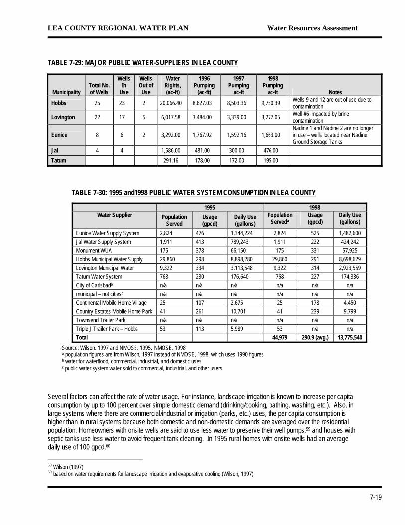
TABLE 7-29: MAJOR PUBLIC WATER-SUPPLIERS IN LEA COUNTYMunicipality Total No. of Wells
Wells In
Use
Wells Out of Use
Water Rights, (ac-ft)
1996 Pumping
(ac-ft)
1997 Pumping
ac-ft
1998 Pumping
ac-ft Notes
Hobbs 25 23 2 20,066.40 8,627.03 8,503.36 9,750.39 Wells 9 and 12 are out of use due to contamination
Lovington 22 17 5 6,017.58 3,484.00 3,339.00 3,277.05 Well #6 impacted by brine contamination
Eunice 8 6 2 3,292.00 1,767.92 1,592.16 1,663.00 Nadine 1 and Nadine 2 are no longer in use – wells located near Nadine Ground Storage Tanks
Jal 4 4 1,586.00 481.00 300.00 476.00 Tatum 291.16 178.00 172.00 195.00
7-19
TABLE 7-30: 1995 and1998 PUBLIC WATER SYSTEM CONSUMPTION IN LEA COUNTY
1995 1998 Water Supplier Population
Served Usage (gpcd)
Daily Use (gallons)
Population Serveda
Usage (gpcd)
Daily Use (gallons)
Eunice Water Supply System 2,824 476 1,344,224 2,824 525 1,482,600 Jal Water Supply System 1,911 413 789,243 1,911 222 424,242 Monument WUA 175 378 66,150 175 331 57,925 Hobbs Municipal Water Supply 29,860 298 8,898,280 29,860 291 8,698,629 Lovington Municipal Water 9,322 334 3,113,548 9,322 314 2,923,559 Tatum Water System 768 230 176,640 768 227 174,336 City of Carlsbadb n/a n/a n/a n/a n/a n/a municipal – not citiesc n/a n/a n/a n/a n/a n/a Continental Mobile Home Village 25 107 2,675 25 178 4,450 Country Estates Mobile Home Park 41 261 10,701 41 239 9,799 Townsend Trailer Park n/a n/a n/a n/a n/a n/a Triple J Trailer Park – Hobbs 53 113 5,989 53 n/a n/a Total 44,979 290.9 (avg.) 13,775,540
Source: Wilson, 1997 and NMOSE, 1995, NMOSE, 1998 a population figures are from Wilson, 1997 instead of NMOSE, 1998, which uses 1990 figures b water for waterflood, commercial, industrial, and domestic uses c public water system water sold to commercial, industrial, and other users
Several factors can affect the rate of water usage. For instance, landscape irrigation is known to increase per capita consumption by up to 100 percent over simple domestic demand (drinking/cooking, bathing, washing, etc.). Also, in large systems where there are commercial/industrial or irrigation (parks, etc.) uses, the per capita consumption is higher than in rural systems because both domestic and non-domestic demands are averaged over the residential population. Homeowners with onsite wells are said to use less water to preserve their well pumps,59 and houses with septic tanks use less water to avoid frequent tank cleaning. In 1995 rural homes with onsite wells had an average daily use of 100 gpcd.60 59 Wilson (1997) 60 based on water requirements for landscape irrigation and evaporative cooling (Wilson, 1997)
LEA COUNTY REGIONAL WATER PLAN Water Resources Assessment
7.1.6 Irrigation Practices Flood, sprinkler, and drip irrigation are used throughout the Lea County, however, sprinkler irrigation is used on 90 percent of the acreage. Consumptive irrigation requirements for the three types of irrigation within the Lea County are shown on TABLE 7-24. The type of irrigation used can depend on cost, ground slope, soil type, crop type, weather, and desire for water and soil conservation.
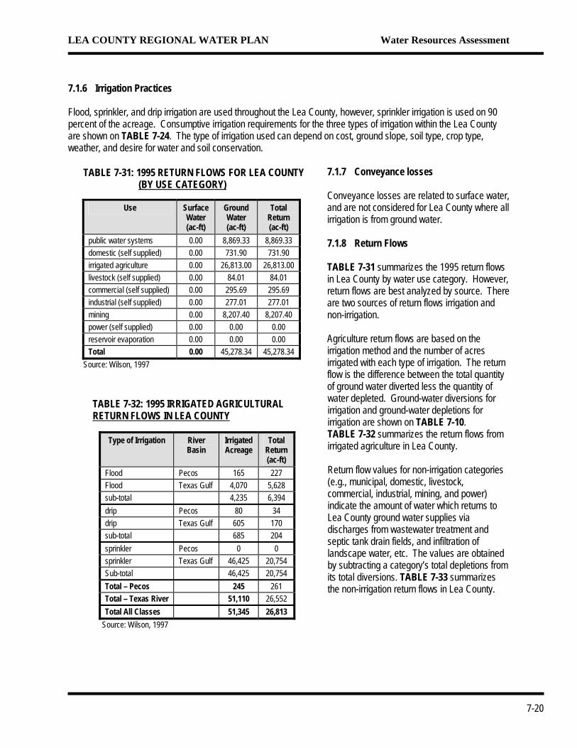
7.1.7 Conveyance losses Conveyance losses are related to surface water, and are not considered for Lea County where all irrigation is from ground water. 7.1.8 Return Flows TABLE 7-31 summarizes the 1995 return flows in Lea County by water use category. However, return flows are best analyzed by source. There are two sources of return flows irrigation and non-irrigation. Agriculture return flows are based on the irrigation method and the number of acres irrigated with each type of irrigation. The return
TABLE 7-31: 1995 RETURN FLOWS FOR LEA COUNTY (BY USE CATEGORY)
Use Surface Water (ac-ft)
Ground Water (ac-ft)
Total Return (ac-ft)
public water systems 0.00 8,869.33 8,869.33 domestic (self supplied) 0.00 731.90 731.90 irrigated agriculture 0.00 26,813.00 26,813.00 livestock (self supplied) 0.00 84.01 84.01 commercial (self supplied) 0.00 295.69 295.69 industrial (self supplied) 0.00 277.01 277.01 mining 0.00 8,207.40 8,207.40 power (self supplied) 0.00 0.00 0.00 reservoir evaporation 0.00 0.00 0.00 Total 0.00 45,278.34 45,278.34
Source: Wilson, 1997
TABLE 7-32: 1995 IRRIGATED AGRICULTURAL RETURN FLOWS IN LEA COUNTY
Type of Irrigation River
Basin Irrigated Acreage
Total Return (ac-ft)
Flood Pecos 165 227 Flood Texas Gulf 4,070 5,628 sub-total 4,235 6,394 drip Pecos 80 34 drip Texas Gulf 605 170 sub-total 685 204 sprinkler Pecos 0 0 sprinkler Texas Gulf 46,425 20,754 Sub-total 46,425 20,754 Total – Pecos 245 261 Total – Texas River 51,110 26,552 Total All Classes 51,345 26,813
Source: Wilson, 1997
flow is the difference between the total quantity of ground water diverted less the quantity of water depleted. Ground-water diversions for irrigation and ground-water depletions for irrigation are shown on TABLE 7-10. TABLE 7-32 summarizes the return flows from irrigated agriculture in Lea County. Return flow values for non-irrigation categories (e.g., municipal, domestic, livestock, commercial, industrial, mining, and power) indicate the amount of water which returns to Lea County ground water supplies via discharges from wastewater treatment and septic tank drain fields, and infiltration of landscape water, etc. The values are obtained by subtracting a category’s total depletions from its total diversions. TABLE 7-33 summarizes the non-irrigation return flows in Lea County.
7-20
LEA COUNTY REGIONAL WATER PLAN Water Resources Assessment
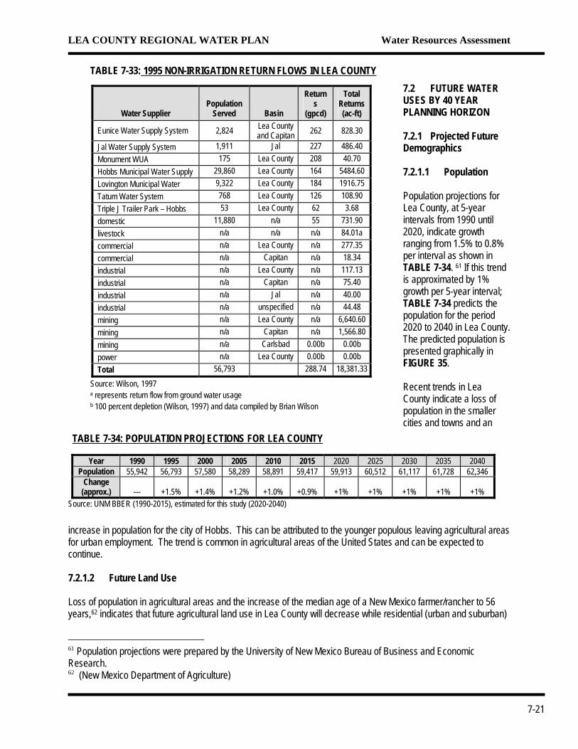
TABLE 7-33: 1995 NON-IRRIGATION RETURN FLOWS IN LEA COUNTY
Water Supplier Population
Served Basin
Returns
(gpcd)
Total Returns (ac-ft)
Eunice Water Supply System 2,824 Lea County and Capitan 262 828.30
Jal Water Supply System 1,911 Jal 227 486.40 Monument WUA 175 Lea County 208 40.70 Hobbs Municipal Water Supply 29,860 Lea County 164 5484.60 Lovington Municipal Water 9,322 Lea County 184 1916.75 Tatum Water System 768 Lea County 126 108.90 Triple J Trailer Park – Hobbs 53 Lea County 62 3.68 domestic 11,880 n/a 55 731.90 livestock n/a n/a n/a 84.01a commercial n/a Lea County n/a 277.35 commercial n/a Capitan n/a 18.34 industrial n/a Lea County n/a 117.13 industrial n/a Capitan n/a 75.40 industrial n/a Jal n/a 40.00 industrial n/a unspecified n/a 44.48 mining n/a Lea County n/a 6,640.60 mining n/a Capitan n/a 1,566.80 mining n/a Carlsbad 0.00b 0.00b power n/a Lea County 0.00b 0.00b Total 56,793 288.74 18,381.33
Source: Wilson, 1997 a represents return flow from ground water usage b 100 percent depletion (Wilson, 1997) and data compiled by Brian Wilson
7.2 FUTURE WATER USES BY 40 YEAR PLANNING HORIZON 7.2.1 Projected Future Demographics 7.2.1.1 Population Population projections for Lea County, at 5-year intervals from 1990 until 2020, indicate growth ranging from 1.5% to 0.8% per interval as shown in TABLE 7-34. 61 If this trend is approximated by 1% growth per 5-year interval; TABLE 7-34 predicts the population for the period 2020 to 2040 in Lea County. The predicted population is presented graphically in FIGURE 35.
TABLE 7-34: POPULATION PROJECTIONS FOR LEA COUNTY
Year 1990 1995 2000 2005 2010 2015 2020 2025 2030 2035 2040 Population 55,942 56,793 57,580 58,289 58,891 59,417 59,913 60,512 61,117 61,728 62,346
Change (approx.)
---
+1.5%
+1.4%
+1.2%
+1.0%
+0.9%
+1%
+1%
+1%
+1%
+1%
Source: UNM BBER (1990-2015), estimated for this study (2020-2040)
Recent trends in Lea County indicate a loss of population in the smaller cities and towns and an
increase in population for the city of Hobbs. This can be attributed to the younger populous leaving agricultural areas for urban employment. The trend is common in agricultural areas of the United States and can be expected to continue. 7.2.1.2 Future Land Use Loss of population in agricultural areas and the increase of the median age of a New Mexico farmer/rancher to 56 years,62 indicates that future agricultural land use in Lea County will decrease while residential (urban and suburban)
61 Population projections were prepared by the University of New Mexico Bureau of Business and Economic Research. 62 (New Mexico Department of Agriculture)
7-21
LEA COUNTY REGIONAL WATER PLAN Water Resources Assessment
use will increase. The rapidly growing dairy industry may partially offset this by using more land for dairy farms and increasing the need for irrigated agricultural to supply feed for their herds. Recent increases in retail, trade, and service employment63 indicate that the number of commercial properties will increase. Commercial properties are usually located within or near cities and towns. The development of industrial parks in Hobbs, Lovington, and Jal may be the beginning of this trend. Future land use by the mining and the petroleum industries is expected to remain constant in the short-term and then decline gradually.64 Market demands, particularly for oil and potash, will periodically cause deviations from this trend. 7.2.1.3 Economic Growth and Jobs Recent growth in the retail, trade, services, and government work sectors, combined with decreases in mining and petroleum indicate that future jobs in Lea County may move away from the traditional employment areas of agriculture, mining, and oil. Recent growth includes the construction of a state prison in the City of Hobbs. Proposed growth includes construction of federal prison and expansion of an existing cheese factory in Lovington, plus construction of a horse racetrack near Hobbs. 7.2.2 Projected Water Demands by Category of Use Future water use by category was estimated by plotting past use (1975 to 1998) and constructing trend lines through known data to obtain an estimated value for the year 2040. Other (non-NMOSE) pertinent population, economic, agricultural, and water use data and factors were obtained, evaluated, and used to finalize the estimates. Increased water use is expected to occur in all categories. By comparison, the largest use of water in Lea County occurs in the Irrigated Agricultural category; and - the water needs of Irrigated Agriculture are expected to increase due to the growing needs of the dairy industry. Unrestrained, the total annual water required by Lea County in the year 2040 is estimated to be between 342,070 acre-feet to 362,390 acre-feet. 7.2.2.1 Irrigated Agriculture Decreases in water use by irrigated agricultural can be expected during periods of above normal precipitation, high production costs, low market prices, decreased cultivation acreage, and with the increased use of efficient irrigation methods. It is likely that, in the future, these factors will be offset by the increased demands of the burgeoning dairy industry. At present, Lea County is not able to supply the food needs of its dairy herds or the milk needs of the cheese factory located in Lovington. The cheese factory in Lovington is planning to increase future production by as much as 400%. It’s estimated that there are now 16,000 mature milking cows and 14,000 immature hefers and calves in the County.65 Dairy farmers in Lea County estimate that herds will increase by 4,000 during the next five years. Future water use predictions include an increase of 4,000 cows every five years and the resulting impact feeding these herds will have on cultivated acreage. Based on average food consumption per cow and Lea County crop yields, a total of approximately 55,000 acres of irrigated farmland is required now to feed the current dairy herd population. Herd increases of 4,000 every 5 years would require an additional 7,300 acres of irrigated farmland every 5 years. Unrestrained, the total water use in Lea County, assuming current CRP acreage will remain fallow, is estimated to increase by 94% during the next 40 years (FIGURE 36 AND TABLE 7-35). The increase is predicted to grow at a slow rate during the first 10 years and at a faster rate during the last 30 years. Future water management and 63 Smith (2000) 64 Smith (2000) 65 Dairy Farmers
7-22
LEA COUNTY REGIONAL WATER PLAN Water Resources Assessment
TABLE 7-35: LEA COUNTY WATER USE IN 2040 (with Current CRP Acreage Remaining Fallow)
Water Use Category Year 1995
Year 2040
% Change
Public Water Supply 16,153 25,000 +55 Domestic 1,331 2,100 +58 Irrigated Agricultural 131,163 268,900 +105 Livestock 1,497 6,950 +364 Commercial 1,346 2,120 +58 Industrial 1,497 3,500 +134 Mining 18,975 25,00 +32 Power 4,445 27,000 +507 Recreation n/r 1,500 +55a
Total Use 176,407 362,070 +94 Note: n/r: not reported a) based on change from 1998 data
conservation practices, particularly for irrigated agriculture, have been applied as a reduction throughout the 40-year period. However, in response to the growing dairy industry, much of the current CRP acreage (approximately 38,000 acres) could be returned into use. If CRP acreage is returned, it will occur in the next 10 years and during that time will increase the total need for water in Lea County by 11% over today’s demand. At the end of 40 years, returned CRP acreage will boost Lea County’s need by 105% (FIGURE 36 AND TABLE 7-36), 19% greater than the estimated need if CRP acreage were to remain fallow.
TABLE 7-36: LEA COUNTY PROJECTED WATER USE IN 2040 (with Current CRP Acreage Returning)
Water Use Category Year 1995
Year 2040
% Change 1995-2040
Public Water Supply 16,153 25,000 +55 Domestic 1,331 2,100 +58 Irrigated Agricultural 131,163 289,220 +120 Livestock 1,497 6,950 +364 Commercial 1,346 2,120 +58 Industrial 1,497 3,500 +134 Mining 18,975 25,000 +32 Power 4,445 27,000 +507 Recreation n/r 1,500 +55a
Total Use 176,407 382,390 +105 Note: n/r: not reported a) based on change from 1998 data
Declining aquifer levels, new USDA financing programs, and ever increasing power costs will cause increased use of LEPA irrigation systems in Lea County. Today, 10% of the irrigated acreage uses LEPA systems. This Plan assumes that within the next 15 years most of the remaining and all the newly irrigated acreage will use LEPA systems. Those increases are projected to be at 30% over each 5-year interval, until total use occurs in 2015. A water use reduction factor of 30% (LEPA efficiency vs. center pivot efficiency) was applied to the growing portion of the irrigated acreage projected to use LEPA systems during the period of 2000 to 2015. The reduction factor was applied to both the ‘CRP land returning’ and the ‘CRP land remaining fallow’ scenarios. 7.2.2.2 Mining Since the late 1980’s a downward trend in water use by mining has occurred. This may be the result of more efficient use and more available commercially provided water. However, water use
by mining, including both petroleum and mineral, is projected to increase by 32% to over 25,000 acre-feet in the next 40 years. This projection, shown on FIGURE 38., would be a return to usage levels that occurred 20 years ago. Increased petroleum demand and higher market prices, as well the availability of new, water intensive, mineral extraction technology are predicted to increase the use of water for mining by 32% in the next 40 years. The discovery of new reserves (mineral or petroleum) could also cause an increase in water use by Mining. 7.2.2.3 Public Water Supply Public Water Supply is estimated to increase by approximately 55%, to 9,000 acre-feet per year, in the next 40 years as shown on FIGURE 39. Water use per person on Lea County public water systems is growing faster than the population. While the number of residents served by public systems in Lea County has been increasing at about 1% per year, the increase in water used by public systems has at 3% per year.
7-23
LEA COUNTY REGIONAL WATER PLAN Water Resources Assessment
7.2.2.4 Domestic Domestic water use has remained stable in the past (Figure 39), except for short-term increases during periods of drought. It is estimated that future water use in this category will increase 58% over the next 40 years to 2,100 acre-feet per year. Small subdivisions built near cities, industrial areas, or vacated farmland that (in order to keep housing costs low ) are not connected to public systems, will be a large part of this increase. 7.2.2.5 Livestock Livestock water use is predicted to increase in response to the previously referenced growth of the dairy industry. Livestock water use is expected to increase by 364%, to 6,950 acre-feet per year, by 2040 as shown on FIGURE 40. 7.2.2.6 Commercial Commercial water use in Lea County is expected to increase in correspondence with the growth in commercial facilities and as increases and water sales may be used to supplement mining and industry uses (FIGURE 41). The sharp drop in Commercial water use that occurred during the 1990's may be attributed to decreases in oil and gas production. Commercial water use is estimated to increase 58%, to 2,120 acre-feet per year, by the year 2040 (Table 75). Industrial water use is likely to increase due to future development of industry (FIGURE 42), even though declines in recent years have occurred. This estimated increase depends upon future economic growth in Lea County. Lea County has an active economic development corporation and several vacant large facilities. Due to the known limited supply of area aquifers, it is assumed that industrial growth will be limited to industries that utilize low volumes of water or are capable of recycling a majority of their process water. Industrial water use is estimated to increase 134%, to 3,500 acre-feet per year, by the year 2040. 7.2.2.7 Recreation Water use by Recreation is expected to increase over the next 40 years as influenced by increases in urban and suburban populations. Recreation use typically includes self supplied water for campgrounds, resorts, ponds, lakes, parks, golf courses, etc., however, golf courses may also appear under Public Supply and Commercial uses. Recreation use has not been consistently recorded in the past and may not be individually recorded in the future. As a result, a use trend graph has not been prepared for Recreation use. The estimated increase of water use by Recreation to 1,500 acre-feet per year is an increase of 55% compared to incomplete 1998 NMOSE data. Water use by Power is expected to increase in the future due to the ever-increasing electrical needs of residential and commercial entities. Development of industry requiring large quantities of power could cause additional demands by this use category. Decreases of water use by Power in past years may be attributed to more efficient uses of water, however, recent use increases have occurred. Two gas-fired electric production turbines will be constructed in Lea County within the next 3 years to supply the regional power grid.. Lea County has been chosen for this project due to the availability of natural gas from the petroleum industry. Each turbine will require 5,000 acre-feet of water per year. It is estimated that two additional turbines will also be constructed in Lea County within the next 40 years. Therefore, it is estimated that a 507% increase in water use by Power, to 27,000 acre-feet per year, will occur by year 2040. 7.2.3 Projected Changes in Water Supplies in Region
7-24
LEA COUNTY REGIONAL WATER PLAN Water Resources Assessment
Several studies with ground-water models have been completed by the NMOSE to predict future depletion of the Lea County UWB (Ogallala Aquifer). The most recent,66 estimated that pumping rates from 1993 to 1996 will cause drawdowns of 10 to 60 feet during the next 40 years. Estimated drawdowns in the area of Hobbs, Lovington, and Tatum by the year 2040 are approximately 35, 25, and 10 feet, respectively. The projected saturated thickness of the Ogallala Aquifer in the year 2040 at Hobbs, Lovington, and Tatum is approximately 50, 100, and 50 feet respectively. The effect of ground-water withdrawals in Texas and their affect upon Lea County was also modeled. Due mostly to Texas withdrawals, drawdowns as high as 20 feet, by the year 2040, were predicted along the New Mexico-Texas line; a drawdown of 10 feet was predicted just east of Hobbs. The report noted a high degree of uncertainty about future water use in both New Mexico and Texas, but concluded that the current rate of depletion is sustainable for the next 40 years. Potable water supplies in the Capitan, Carlsbad, and Jal UWB's are not expected to change significantly during the next 40 years as predicted population, commercial, and industrial growth in these areas is expected to be minimal. 7.3 SUMMARY OF PRESENT & FUTURE WATER DEMAND Water demand in Lea County increased 33% from 1985 to 1995 and is presently about 180,000 acre-feet per year.67 Similar increases in water use from 1985 to 1995 occurred in Irrigated Agriculture (33%), Public Supply (26%), Domestic (40%), Livestock (106%), and Commercial (21%) use categories.68 During 1995 to 1998 Industrial use increased 69%. Decreases in water use occurring during 1985 to 1995 in the Mining (-26%) and Power (-22%) categories; these declines are attributed increases to process efficiency. Present water use by category, as a percentage of Lea County’s total, is 78% Irrigated Agricultural, 10% for Public Water Supply, 7% Mining, and 3% Power. Present water use by Domestic, Livestock, Commercial Reservoir Evaporation, and Recreation uses are all less than 1% of the total use. This increase in water use is far in excess of the County’s population growth. The disparity is perhaps best portrayed by the direct relationship between population a residential use; the County’s population is increasing at only about 1% a year, but residential use is increasing annually at 10%. Over the next 40 years –if unrestrained-- the water use in Lea County is estimated to increase to approximately 360,000 acre-feet, 105% greater than the 1995 total; this assumes the current CRP acreage returns to irrigated farmland. The largest part of this increase is anticipated to come from Irrigated Agricultural, which is projected to require 290,000 acre-feet in 2040, in response to demands for feed from Lea County’s expanding dairy industry. If the current CRP acreage remains fallow, the estimated total annual water use in year 2040 is estimated to be a 340,000 acre-feet per year (of which Irrigated Agricultural will require about 270,000 acre-feet), a 94% increase compared to 1995. All other water use categories are expected to increase in Lea County over the next 40 years. Specifically, 55% Public Supply, 58% Domestic, 364% Livestock, 58% Commercial, 134% Industrial, 32% Mining, 57% Power, and 55% Recreation are estimated above 1995 uses. These other categories account for a total of approximately 70,000 acre-feet per year of the total annual 2040 estimate.
66 Musharrafieh and Chudnoff (1999) 67 incomplete 1998 NMOSE data) 68 Recreation water use was not calculated because of a lack of data.
7-25