Embed Size (px)
Citation preview

in Geology
AN ABSTRACT OF THE THESIS OF
WILLIAM CHARLES TRAUBA for the degree MASTER OF SCIENCE(Name of student) (Degree)
presented on /775(Major Department) (]Yate)
Title: PETROGRAPHY OF PRE-TERTIARY ROCKS OF THE
BLUE MOUNTAINS, UMATILLA COUNTY, NORTHEAST
OREGON
Abstract approved:Dr. William H. Taubeneck
Nine small Mesozoic plutons in TJmatilla County, northeast
Oregon, crop out within an area of 58 sq km in the Blue Mountains.
The plutons are divided into an earlier series of probable Permian-
Triassic age and a later intrusive series of probable Late Jurassic
to Middle Cretaceous age. The earlier rocks show effects of
regional metamorphism whereas the later plutons are unmeta-
morphosed.
The five units of the earlier intrusive series probably are
Early to Middle Trias sic in age. They correlate in age and general
petrologic type with the Canyon Mountain ophiolite complex. Rock
types, whcch may vary within individual plutons, are serpentinized
peridotite, quartz-hornblende metagabbro, hornble nde metatonalite,
and hornblende metatrondhjemite The elongation of
/7/ /.(/J

several plutons suggests that emplacement was guided by northeast-
trending zones of weakness. All plutons were intruded as magmas
except the peridotite which was probably tectonically emplaced.
Intrusion of these units into the country rock produced a hornblende
gneiss and thermal metamorphism up to the sillimanite-cordierite-
muscovite-almandine subfacies of Abukuma-type facies series
metamorphism. Permian-Triassic regional metamorphism of
greenschist grade produced a pronounced northeast foliation in the
older series of plutons and associated country rocks.
The remaining four plutons are included within a later intru-
sive episode and are probably Late Jurassic to Middle Cretaceous in
age. Age and petrologic type are typical of the Wallowa and Bald
Mountain intrusive series. Rock types, in the order of intrusion,
are pyroxene-hornblende melagabbronorite; quartz-pyroxene-
hornblende gabbronorite; biotite -bearing, quartz-hornblende gabbro;
hornblende trondhjemite, and granodiorite.
Country rocks are metavolcanic dacitic and andesitic flows
and pelitic metasedimentary schists, interbedded on a large scaJe.
They presumably correlate with portions of the Elkhorn Ridge
Argillite and/or the Clover Creek Greenstone on the basis of
lithologic similarities. Staurolite, not found in pre-Tertiary rocks
elsewhere in northeast Oregon, is common in the metasediment
A series of interbedded sediments and flows unconformably

overlies the pre-Tertiary rocks. The sediment ranges from carbon-
aceous shale to arkose. Abundant leaf fossils indicate an early
or middle Eocene age. Foreset beds, angular grains, and the
occurrence of staurolite suggest that the sediment is locally derived
from outcrops to the southeast and deposited under fluvial conditions.
Most flows are andesitic and commonly contain 30 to 40 percent large
phenocrysts of piagioclase, mica, quartz, and hornblende, Post-
Eocene deformation has tilted the sediments eastward as much as
37 degrees.
Columbia River Basalt unconformably overlies the tilted
Eocene strata, Only Yakima-type basalt was found. One prominent
flow contains small phenocrysts of plagioclase and is sufficiently
distinctive to serve as a marker unit. Gentle northeast-trending
folds and small, inconspicuous northwest faults are the chief
structural characteristics of the basalt.
Quaternary sediments include the loessial Palouse Formation,
reworked deposits of Mount Mazama ash, and stream gravels.
Chemical analyses of the major oxides, trace elements, and
rare earths show consistently low amounts of Ti02 and K2O and
depletion in the light rare earths. These chemical data combined
with petrologic similarities to known ophiolite complexes suggest
that the Permian-Triassic (? ) units in the thesis area represent a
dismembered ophiolite assemblage. The sialic metasediment

suggests a continental provenance; the source of the metavolcanic
unit is possibly from an island arc. Together they suggest deposi-
tion in a Permian-Triassic back-arc environment.

Petrography of Pre-Tertiary Rocks of the Blue Mountains,Umatilla County, Northeast Oregon
y
William Charles Trauba
A THESIS
submitted to
Oregon State University
in partial fulfillment ofthe requirements for the
degree of
Master of Science
June 1975

APPROVED:
/Professor of Geology
in charge of major
Head of Department of Geology
Dean of Graduate School
/ I -
Typed by Ilene Anderton and Lyndalu Sikes for William CharlesT rauba
Date thesis s presented /774

ACKNOWLEDGEMENTS
The author would like to warmly express his appreciation to
William Taubeneck for his abundant technical and financial assistance.
His practical advice and experience immeasurably aided the success-
ful completion of the project.
The author is also indebted to Jack Wolfe of the United States
Geological Survey for gratuitously devoting his time and effort to
examine several fossil leaf collections.
Thanks are also extended to Robert Lawrence for his enlight-
ening discussions of the structural geology, and to Roman Schmitt
for his helpful advice concerning the chemistry of rare earth
elements.

TABLE OF CONTENTS
Chapter Page
INTRODUCTION 1
General Statement 1
Description of the Area 2
Previous Work 5
Methods of Investigation 6
GENERAL GEOLOGY 9
PETROGRAPHIC UNITS 11
General Statement 11
UNITS OF THE METAMORPHOSEDCOUNTRY ROCK 12
Metasedimentary Unit 12Field Characteristics 12Petrography 14
Metavolcanic Unit 19Field Characteristics 19Petrography 22
Hornblende Gneiss 25Field Characteristics 25Petrography 28
PLUTONS OF THE FIRST MAGMATICEPISODE 31
Serpentinized Peridotite of Stanley Creek 31
Field Characteristics 31
Petrography 32Quartz-.Hornblende Metagabbro 35
Field Characteristics 35Petrography 37
Hornblendite 41Field Characteristics 41Petrography 43
Hornblende Metatonalite of California Gulch 46Field Characteristics 46Petrography 48
Hornblende Metatrondhjemite of PearsonCreek 51
Field Characteristics 51
Petrography 52

Chapter Page
PLUTONS OF THE SECOND MAGMA4TICEPISODE 58
Pyroxene-Hornblende Melagabbronorite ofRidenor Canyon 58
Field Characteristics 58Petrography 59
Quartz-Pyroxene -Hornblende Gabbronoriteof Carney Butte 65
Field Characteristics 65Petrography 66
Biotite-bearing, Quartz-Hornblende Gabbroof Alexander Creek 75
Field Characteristics 75
Petrography 78Hornblende Trondhjemite of Johnson Creek 85
Field Characteristics 85Petrography 86
Granodiorite of Table Mountain 90Field Characteristics 90Petrography 92
Petrography of a Trondhjemite Dike 96
CENOZOIC UNITS 99Eocene Strata 99
Field Characteristics 99Andesite Porphyry 100
Field Characteristics 100Petrography 100
Porphyritic Rhyolite 105Field Characteristics 105
Sedimentary Strata 106Field Characteristics 106Petrography 108
Mafic Sill 111Field Characteristics 111Petrography 113
Columbia River Basalt 115Field Characteristics 115
Quaternary Sediments 118
CHEMISTRY 120
IX. METAMORPHIC GEOLOGY 137

Chapter
X. STRUCTURAL GEOLOGYPermian-Triassic DeformationDeformation Associated with Intrusive
ActivityCenozoic Deformation
GEOLOGIC HISTORY 156
IMPLICATIONS FOR PLATE TECTONICS 165
REFERENCES CITED 167
Page
141141
143148

LIST OF ILLUSTRATIONS
Figure Page
Location map of thesis area. 3
Randomly oriented muscovite porphyroblastsin the foliated metasedimentary unit. 16
Euhedral staurolite in pelitic schist. 16
Biotite transitional into needles of sillimanite. 18
Shear zone in the metavolcanic unit showingdeformed clasts. 21
Texture of the metavolcanic rock showingphenocrysts of quartz and plagioclase. 21
Hornblende gneiss. 26
Sample location map of the serpentinizedperidotite of Stanley Creek. 33
Green hornblende transitional into areas ofcolorless amphibole, probably tremolite, inthe hornblendite. 44
Sample location map of the hornhlendemetatrondhjemite of Pearson Creek. 55
Undulatory extinction in quartz and mortartexture in the hornblende rnetatrondhjemiteof Pearson Creek. 56
Sample location map of the pyroxene-hornblendemelagabbronorite of Ridenor Canyon. 61
Possible cumulate texture of augite andhypersthene in poikiolitic hornblende. 63
Sample location map of the quartz-pyroxenehornblende gabbronorite of Carney Butte. 69

Figure Page
Hypersthene showing schiller. 71
Exsolution in hypersthene. 71
Hypersthene rimmed by colorlesscummingtonite transitional into hornblende. 72
Poikiolitic hornblende interstitial toall grains. 72
Oriented xenoliths in the biotite -bearing,quartz-hornblende gabbro of AlexanderCreek. 77
Xenolith of hprnblendite in the AlexanderCreek pluton. 77
Contact between the Columbia River Basaltand the Alexander Creek pluton showing areddish baked zone. 79
Sample location map of the Alexander Creekpluton. 82
Vermicular inclusions of quartz in hornblendeindicating the former presence of pyroxene. 84
Sample location map of the Johnson Creekpluton. 87
Oscillatory zoning in plagioclase in thehornblende trondhjernite of Johnson Creek. 89
Myrmekite penetrating a large grain ofpotassium feldspar in the granodiorite ofTable Mountain. 95
Stratigraphic column of Eocene rocks alongEast Birch Creek at location 66. 101
28. Texture of the andesite porphyry showingintense alteration. 103

Figure Page
Outcrop pattern of rhyolitic and andesiticflows along East Birch Creek. 109
Truncated cross-bedding resembling foresetbeds in the arkose, 109
Angular quartz grains inarkose. 112
Texture of arkose. 112
33, Orbicular structure in the mafic sill. 114
Harker diagram of each major oxide versussilica. 128
AFM diagram showing slight iron enrichmentof Permian-Triassic (?) plutons relative toLate Jurassic-Middle Cretaceous (?) plutons. 130
Variation diagram comparing Permian-Triassic(?) plutons and Late Jurassic-Middle Cretaceous(?) plutons of the thesis area and plutons of theBald Mountain batholith with chemical trendsof the Cornucopia tonalite, Craig Mountainintrusion, Needle Point intrusion, and theHurricane Divide intrusion of the Wallow3batholith. (Sample 148 is excluded.) 131
Whole rock REE abindance patterns. 134
Geologic cross section EFG of Plate 1. 142
Stereoplot of foliation in the metavolcanicunit along Pearson Creek. 145
Stereoplot of foliation in the metasedimentaryand metavolcanic units in the West BirchCreek area. 145
Stereoplot of foliation in the metasedimentaryunit in the Bear Creek area showing post-metamorphic deformation. 145
Figure Page
Stereoplot of foliation in the hornblendegneiss from Stanley Creek to East BirchCreek. 145
Stereoplot of foliation in the metagabbroalong West Birch Creek. 146
Stereoplot of foliation in the metagabbroalong Stanley Creek and California Gulch. 146
Stereoplot of foliation in the met atonaliteof California Gulch. 146
Composite of Figures 40, 42, 43, 44,and 45. 146
Small isoclinal folds in the pelitic schistalong Yellow Jacket Road. 149
Blue Mountain anticline. 149
Upturned basalt forming a uhinge linet alongthe northwest flank of the Blue Mountains. 153
SO. Minor faulting in Columbia River Basalt. 153
51. Gouge zone in the Columbia River Basalt. 154
Plate1. Geologic map of the northeast part of the
Blue Mountains, Umatilla County, Oregon. Pocket
2. Contour map of Eocene topography plusdeformation. Pocket
3. Contour map of Miocene topography. Pocket

LIST OF TABLES
Table Page
Modes of the quartz-hornblende metagabbro. 39
Modes of the hornblende metatonalite ofCalifornia Gulch. 50
Modes of the hornblende metatrondhjemiteof Pearson Creek. 54
Modes of the pyroxene-hornblendemelagabbronorite of Ridenor Canyon. 60
Modes of the quartz-pyroxene-hornblendegabbronorite of Carney Butte. 68
Modes of the biotite-bearing, quartz-hornblende gabbro of Alexander Creek. 81
Modes of the granodiorite of Table Mountain. 93
8 Chemical analyses and norms. 121
Chemical analyses of standard rock types. 123
Trace element analyses. 124
Rare earth abundance ratios. 133

PETROGRAPHY OF PRE-TERTIARY ROCKSOF THE BLUE MOUNTAINS,
UMATILLA COUNTY.NORTHEAST OREGON
INTRODUCTION
General Statement
The igneous and metamorphic rocks of the thesis area compose
the only pre-Tertiary exposures for 160 km to the northeast and for
several hundred kilometers to the north and west of the thesis area.
Accordingly, these rocks are critical in understanding the pre-
Tertiary evolution of the Pacific Northwest. Detailed mapping of
these units along the core of the Blue Mountain anticline was not
possible until 1967 when U.S.G.S. 7-1/2' cjuadrangle sheets became
available.
The primary objective of this report is to provide a detailed
map and petrographic description of the pre-Tertiary rocks.
Secondary objectives include determination of the prevailing meta-
morphic grade and a description of the structural geology. The
ultimate objective is to synthesize information from the thesis area
with data pertaining to the regional geology in an attempt to form a
comprehensive picture of the geologic evolution of this part of
northeast Oregon.

Description of the Area
The thesis area encompasses approximately 260 sq km (100
sq mi) and includes 68 sq km (26 sq mi) of pre-Columbia River
Basalt rocks which were mapped in detail. The remainder of the
thesis area, 192 sq km of Columbia River Basalt, received only a
cursory examination.
The thesis area approximates an 8 by 32 km (5 by 20 mile)
northeast-southwest strip bounded on the west by long 119°00' W;
on the east approximately by long 118°42 30! W; on the north by a
line extending along the north border of sec. 7, T. 2 S., R. 32 E.
and on the south by lat 45°15 N. (See Figure 1.)
Access is provided by Highway 395, several graveled roads,
and numerous logging trails. No exposure is more than 5 km from a
good road. The nearest town is Pilot Rock, about 8 km north of
the northern border of the thesis area.
The area lies within the Blue Mountain division of the Columbia
Plateau physiographic province (Fenneman, 1931). The Blue
Mountain section was subdivided by Hogenson in 1956 into the upland
plateau of the Blue Mountain highland and the ramplike 'northwest
slope", which he termed the Blue Mountain slope. Altitudes of the
upland plateau are about 1500 m (5000 ft) and decrease to about
900 m (3000 ft) near the north boundary of the thesis area.
2

Figure 1. Location map of thesis area.
3

4
East Birch and West Birch Creeks are the principal streams
of a northward flowing, dendritic drainage pattern which character-
izes the Blue Mountain slope. The streams join at Pilot Rock and
flow northward into the Umatilla River, about 5 km west of
Pendleton. The Umatilla River continues northwest and joins the
Columbia River at Umatilla.
The climate ranges from semiarid in the barren region around
Pilot Rock to a cool temperate climate in the Blue Mountain high-
lands. The temperature exceeds 38°C (100°F) in the summer and
0 0 .falls below -18 C (0 F) several times during the winter. The aver-
age annual temperature at Pilot Rock for 1973 was 11°C (52°F). The
average annual precipitation at Pilot Rock for the same year was
34. 8cm (13. 7 in, ) (U. S. Department of Commerce, Climatological
Data for Oregon, 1973).
Hay, wheat, cattle and logging are the main economic indus-
tries of the area. The hay fields are confined to bottom land along
streams and appear as rivers of green amid large golden wheat fields
and grazing land that are more typical of the Blue Mountain slope.
Dense forests mostly of lodgepole pine and fir cover the north slopes
qf the Blue Mountain highlands, but give way predominately to large
ponderosa pines which dot the south slopes. The line of tree cover
approximates the contact of the moderately weathered pre-Tertiary
rocks and the dense, much less weathered Columbia River Basalt.

Several outliers of basalt rest upon pre-Tertiary rocks and are
readily distinguished at a distance by their lack of tree cover.
Active logging in the highlands has provided many fresh exposures
in the otherwise typically weathered pre-Tertiary rocks.
Previous Work
5
The earliest work in the area is a reconnaissance geologic
map of Umatilla County made by Thomas Hite in 1937 for the Soil
Conservation Service of the Department of Agriculture. In 1954
Wagner expanded upon Hite's map by establishing the approximate
extent of the pre-Tertiary metamorphic and igneous rocks as well
as general structural trends and the character of some rocks, "a
blende of diorite and quartz diorite" (Wagner, 1954, p. 16). In 1956
the area was included by Hogenson in a master's thesis at Oregon
State University, and the report was later expanded into Water
Supply Paper 1620 (Hogenson, 1964). His later report focuses on
ground water reservoirs throughout a large area in the Columbia
River Basalt and his geologic map was derived from reconnaissance
traverses. Although he described several different pre-Tertiary
rock types along the Blue Mountain anticline, e. g. pegmatite, quartz
diorite, ultramafic, gneiss, the small scale of his map (ca.
1:125, 000) precluded delineation of these rock types. His structural
data includes approximate attitudes of the Columbia River Basalt and

6
of several faults within the basalt, but no information is given con-
cerning the structure of the pre-Tertiary rocks.
A master's thesis by Pigg (1961) includes the early Tertiary
volcanic and sedimentary rocks that crop out in the northeast part
of the area. His report does not discuss the preTertiary geology
in any detail, but he concludes that the Tertiary sedimentary units
are the result of material eroded from the higher portions of the
ancestral Blue Mountains and deposited on its flanks (Pigg, 1961,
p. 20).
The most recent map of the area is a 1:250, 000 reconnaissance
geologic map of the Pendleton quadrangle (Walker, 1973). This map
is mainly a compilation of previous geologic mapping onto a
regional scale and is helpful by providing a comprehensive picture of
the regional geology and major structural trends. The data for the
thesis area is taken from Hogenson (1964).
Methods of Investigation
Field work required 12 weeks during the summers of 1973
and 1974. Base maps consist of portions of the Carney Butte,
Granite Meadows, Pilot Rock, Sevenmile Creek, and Tamarack
Gulch 7-1/2' U. S. G. S. quadrangle maps.
One hundred thin sections were examined. Counts of 1500
points on a 0. 5 by 1 mm grid were used to determine modal analyses.

7
The anorthite content of the plagioclases was determined by the
Michel- Levy method.
Petrographic names for plutonic rocks are according to the
classification of the International Union of Geological Sciences
(IUGS) (1973).
Chemical analyses of 13 igneous rocks were made. Fresh,
homogenous samples were trimmed, crushed, and pulverized using
power equipment having steel grinding surfaces. A weakly magne-
tized pin and binocular microscope were used to separate the steel
contamination from the powders. A duplicate but untreated sample
was analysed to check reproducibility. This check revealed that
all values agreed within experimental uncertainty except FeO where
the treated sample contained 7.3 ± 0.1 percent FeO, but the untreated
sample contained 7. 6 ± 0. 1 percent FeO. Final pulverization was
done in a ball mill. The powdered samples were then heated to
render them anhydrous and to bring all of the iron to a uniform
oxidation state. Lithium tetraborate was then added to the powders
and served as a flux to make glass buttons which were used in the
determination of percent Si02, Al2O, FeO, CaO, KO, and Ti02
by x-ray fluorescence. The buttons were pulverized after the x-ray
fluorescence determinations, dissolved, and analyzed for Na20
and MgO using atomic absorption spectra and for Si02 using visible
light spectra. By summing the values to 100 percent, the amount of

8
Si02 determined by x-ray fluorescence was found to be systematic-
ally 2 percent too high. Therefore, only the Si02 values determined
by visible light spectra are quoted.
Eight additional samples were analyzed for major and minor
elements and for some rare earths using instrumental neutron
activation analysis (INAA) techniques and the TRIGA research
reactor at Oregon State University. Short-lived isotopes were
activated using two series of 2-minute rabbit shots 7 days apart for
each sample. The power level for each activation was 25 kw. Long-
lived isotopeswere activated for 4 hours at 1 Mw. Counting of
sodium and manganese was done on a Nal (Ti) analyzer. A Ge(Li)
analyzer was used to count all other isotopes except sodium.
Prepared chemical standards and U. S. G. S. rock standards were
used to calibrate the results. The compositions of the rock
standards were obtained from Flanagan (1972) and from repeated
analyses of these standards at the reactor center.

GENERAL GEOLOGY
The oldest rocks in the area are a band of northeasterly-
trending metasedimentary and metavolcanic rocks of probable
Permian-Triassic age. Their northeasterly trend parallels a
prevalent foliation having moderately steep southeasterly dips.
The central region of the Blue Mountain antic line has been intruded
by a host of plutonic rocks including two gabbronorites, two gabbros,
two ultramafics, two trondhjemites, one tonalite and one grano-
diorite. Two major plutonic suites occur. Metamorphism and
foliation in four of the plutons characterize an older plutonic suite,
whereas foliation in the younger suite is slight or absent and com-
monly parallels contacts. Thermal metamorphism as intense as
the sillimanite- cordierite-muscovite-almandine subfacie s of the
Abukuma-type facies series of Winkler (1967) was recorded in pelitic
country rocks as far as 150 m from an intrusive unit.
A series of early Tertiary, unmetamorphosed sediments, sills,
and flows lies unconformably on the metamorphic and igneous rocks
in the northeast part of the area. The series is either gently folded
or slightly tilted to the east-northeast. Pigg (1961) estimated a
total thickness of about 4Z0 m (1400 ft) for these strata. Abundant
leaf fossils indicate that the rocks are early or middle Eocene in
age (Wolfe, written communication, 1975).
9

10
Columbia River Basalt of Miocene age overlies the Eocene
strata with an angular unconformity and covers most of the thesis
area with a thick series of flows. Erosion of the basalt along and
near the crest of the Blue Mountain anticline has exposed the areas
of pre-Tertiary rocks (Plate 1).
Quaternary gravels occur along stream channels and may
extend as much as 30 m up some hillsides. White siliceous ash,
attributed to the eruption of Mount Mazama, and bess are discon-
tinuously distributed along several stream channels.
Cenozoic faulting is common in the basalt. Nearly all faults
trend northwest and have a small normal or oblique displacement.
An exception is a northeasterly-trending fault which parallels the
Blue Mountain antichne along its northwest flank This fault marks
a 1thinge line's in the basalt where relative movement with the Blue
Mountain anticline has bent the basalt sharply upward.
PETROGRAPHIC UNITS
General Statement
Sixteen mappable petrographic units were recognized and
delineated using the field examination of the thesis area. The units
include metasedimentary, metavolcanic, and hornblende gneiss
country rocks; serpentinized peridotite; two gabbronorites; two
gabbros; hornblendite; two trondhjemites; a tonalite; a granodiorite;
Eocene sediments and volcanics; Columbia River Basalt; and
Quaternary alluvium.
11

UNITS OF THE METAMORPHOSED COUNTRY ROCK
Metasedimentary Unit
Field Characteristics
The metasedimentary unit occurs sporadically throughout
the area of pre-Tertiary exposure in irregularly shaped, northeast-
trending bands which parallel bedding and foliation. The total areal
extent of the unit is about 8 sq km.
The unit is essentially of one lithology: a black,
fine-grained biotite schist. Occasionally it is a phyllite. Several
quartz-rich beds, less than 15 cm thick, occur with the schist in
the NW 1/4 sec. 9, T. 3 5, R. 32 E.
The schist erodes easily by disintegrating into small flakes.
Outcrops are rare and nearly at ground level. The best continuous
exposures are road cuts that occur for about 2 km along the Yellow
Jacket Road. Another well-exposed section is a road cut along
Highway 395 about 3 km south of Battle Mountain State Park.
Structures include a well-defined cleavage which parallels
foliation and bedding. Several kink bands occur in a brownish
phyllite in the SW 1/4 NE 1/4 sec. 9, T. 3 S., R. 32 E. Folding,
generally rare throughout the thesis area, is most common in the
schist. Veins of white quartz are common and are variously folded
12

13
and stretched into boudins and mullions. The folding and boudinage
are particularly well developed along the Yellow Jacket Road and
are characterized by small isoclinal folds plunging at attitudes of
10 degrees or less.
Contacts with adjoining units are generally covered, but their
location can be accurately established to within 6 m by the extent of
ubiquitious fragments of the schist in float. Contacts with the
igneous rocks are commonly gradational over distances varying up
to 400 m as in the E 1/4 sec. 31, T. 3 S., H 31 E. with the biotite-
bearing, quartz-hornblende gabbro of Alexander Creek. There is
considerable intercalation of the intrusive with the schist along
these contacts. The schist becomes hornfelsed and gradually broken
up into xenoliths as the intrusive becomes more mafic by assimilat-
ing portions of the xenoliths. An increase in hornblende and biotite
or biotite alone typifies this change in the gabbro.
The schist is thermally metamorposed to a banded horn-
blende gneiss in the SE 1/4 SE 1/4 sec. 10, T. 3S., H 31 E.., next
to the contact with the gabbro of Alexander Creek. Hydrothermal
fluids have leeched the schist in places along the contact and have
dissolved most of the mafic minerals giving the rock a porous
appearance.

Petrography
Garnet or staurolite is present in each of the seven thin sec-
tions studied. Sillimanite occurs in five slides, one from a rock as
far as 150 m from an intrusive unit,
Minerals include plagioclase, quartz, biotite, muscovite,
garnet, staurolite, sillimanite, zircon, chlorite, white mica, and
iron ore. Sample locations are indicated on Plate 1.
Plagioclase is rarely twinned and is clear except for scatterd
grains of white mica. Composition is difficult to estimate but is
probably no more calcic than ande sine. Grains are polygonal and
the same size as the associated quartz grains.
Quartz is typically clean, polygonal, and unstrained. Sporadic
grains exhibitundulatory extinction, especially along late shears
that cut across foliation. Larger grains of quartz occupy the sites
of partially disinte grated staurolite and sillimanite porphyrobla sts.
Biotite occurs in pleochroic reddish brown laths 3 mm long,
though the reddish tinge is absent in some slides, Grains are
parallel and define one and sometimes two directions of foliation in
addition to a third direction marked by bedding. Pleochroic halos
are visible around inclusions of zircon,
Muscovite is typically embayed and replaced by quartz.
Grains of muscovite transect the biotite in many places and though
14

15
most often parallel to biotite, a considerable number of grains are
randomly arranged at high angles to foliation. These crystals are
the same size or slightly larger than the 0. 1 to 0. 3 mm length of
the biotite. Several large prophyroblasts of muscovite, up to 1. 5
mm in diameter, occur in a randomly oriented fashion in slide 161
(Figure 2) and in a vein in slide 334 associated with the single
occurrence of sillimanite in the slide. The texture is completely
undisturbed indicating that the muscovite postdates foliation. The
porphyroblasts appear virtually identical to those described in the
GlenDistrict, Co., Donegal by Tozer (19 55, p. 318) which he attributedto
a local introduction from the (Don egal) granite of K,F, and (OH) which partly annulled the slightly earlierloss of certain elements (during the formation ofsillimanite) and led to a complex redistribution of thematerial of the schists affected.
Abundant sillimanite is present in slide 161 along with the muscovite
porphyroblasts.
Additional prophyroblasts consist of garnet, staurolite, and
sillimanite, listed in the order of decreasing abundance. Garnet
is typically rounded, faintly pink, and slightly embayed by quartz.
The garnet may be either almandine or spessartite. Most likely
it is spessartite because the manganese garnet is more stable at
lower temperatures and pressures than almandine which is stable
under high-grade conditions (Winkler, 1967). Maximum diameters
are 2 mm.

Figure 2. Randomly oriented muscovite porphyroblasts in thefoliated metasedimentary unit.
Figure 3. Euhedral staurolite in pelitic schist.
16
17
Staurolite is characteristically pleochroic yellow, corroded
and partially replaced by quartz, though euhedral grains are well
displayed in slide 166 (Figure 3). Maximum length is 3 mm.
Inlcusions of vermicular quartz are ubiquitous and form euhedral
outlines in grains cut parallel to {OOl}. Alteration to chlorite
and rims of white mica are present in slide 131 and indicates
retrograde conditions.
Sillimanite forms subhedral porphyroblasts as large as 1 by
1 mm and 3 mm long. Grains are commonly ragged, broken and
partially replaced by quartz. Several crystals are faintly pleochroic
red. Carbon crosses are absent. Transition of the sillimanite
porphyroblasts to needles of sillimanite is visible in several slides.
The acicular habit of the mineral is the more common and the long
slender needles typically weave together to form a matted network.
The interlocking sillimanite mats usually parallel foliation, but
are best developed along cross-cutting shears. Sillimanite is
transitional into biotite (Figure 4) and some muscovite in the
manner described by Tozer (1955). Needles of sillimanite also
rim several garnets.
An opaque, either iron ore or carbon,is finely dispersed in
the lower grade metamorphics and contributes to the black appear-
ance of the schist. At higher temperatures the dust seems to

Figure 4. Biotite transitional into needles of sillimanite.bi=biotite, q=quartz, si= sillimanite,ststaurolite.
18

coalesce to form larger irregular, grains associated with biotite
and chlorite. Iron ore fills cracks in several saurolite porphyro-
blasts.
Metavolcanic Unit
Field Characteristics
Exposures of metavolcanic rocks occur primarily in the
southeast portion of the area. Exposures along Pearson Creek and
northwest of Table Mountain, total about 8 sq km and compose the
surface extent of this unit. The two areas of outcrop are separated
by 5 km of Columbia River Basalt, but they are probably continuous
beneath the basalt, especially because they lie along the trend of
the northeast regional foliation.
The unit is dominantly a dense gray-green hornblende-
chlorite schist, The original volcanic origin is revealed by variously
sheared phenocrysts of quartz and feldspar in some flows. A bed
of siliceous, light colored metatuff about 6 m thick is interbedded
with the hornblende schist in the SW 1/4 NE 1/4 sec. 16, T. 3 S.,
R. 32 E. The metatuff is brittle and faintly banded reddish brown,
but turns white upon weathering. Weathering of the hornblende
schist is slight.
The unit is resistant and commonly crops out as ridges and
19

20
low cliffs. The rock breaks easily along foliation to yield large,
angular blocks.
Most of the unit displays a distinct foliation which strikes
northeast and dips steeply southeast. Where shearing was parti-
cularly intense, the rock is a chlorite schist and any quartz pheno-
crysts have been converted to protruding, rounded knobs. Some
areas such as the NE 1/4 sec. 19, T 3 S., R. 33 E. display an even
more intense shearing. Here the presence of stretched clasts of
hornblende and chlorite schists along with white quartz suggests
the possibility of faulting (Figure 5). An alternative explanation is
that the stretched clasts represent a sheared conglomeritic interbed
instead of fault gouge. The extent of the exposure is too small to
allow the determination of the trend of this zone.
Large veins of white bull quartz as much as 0. 3 m wide are
common throughout the unit. Their folded and irregular character
indicates that they are either pre- or syntectonic.
Contacts with surrounding rocks are obscured, but abundant
angular xenoliths of the metavolcanic rock in the hornblende
metatrondhjemite of Pearson Creek near its border with the meta-
volcanic unit suggest partial assimilation by the intrusive.
Contact metamorphism of the unit is evident in the NE 1/4
sec. 16, T. 3 S., R. 32 E. As one approaches the contact with
the quartz-hornblende metagabbro, the metavolcanic rock changes

Figure 5. Shear zone in the metavolcanic unit showingdeformed clasts.
Figure 6. Texture of the metavolcanic rock showing phenocrystsof quartz (q) and plagioclase.
2.1

22
from its typically aphanitic texture to a medium- grained hornfels
showing gray plagioclase interstitial to dark-green hornblende grains.
Foliation remains distinct, but the rock acquires a more gnei.s sic
charater. When thoroughly hornfelsed, the rock appears very simi-
lar to the finegrained variety of the quartz-hornblende metagabbro.
Pet r o g rap hy
Both aphyric and porphyritic flows were found. Porphyritic
flows are most prevalent along Pearson Creek and display subhedral
phenocrysts of quartz and plagioclase set in an aphanitic groundmass
showing little or no foliation (Figure 6). Many of these flows are
porphyritic dacite. (See locations 17, 19, 21, and 35; Plate 1. ) The
rock is devoid of phenocrysts near intrusives, is fine to medium
grained, and exhibits a pronounced lepidoblastic texture. Minerals
include pla gioclase, hornblende, quartz, biotite, muscovite, apatite,
zircon, epidote, clinozoisite, sphene, white mica, leucoxene,
hematite, and iron ore.
Subhedral plagioclase phenocrysts comprise about 7 percent of
the rock and average 2 mm in diameter. Twinning is common but
poorly developed and twins sometimes display rehealed fractures of
unstrained quartz. More typically, the twinning is partially obscured
by moderate to extreme alteration to white mica, chlorite, epidote,
and clinozoisite. Both albite and carlsbad twins are common;

23
pericline twins are less abundant. Very thin sodic rims surround
some grains and are probably albite. Indices of the refraction of
the plagioclase in all parts of the grains are obviously less than
that of quartz identifying the phenocrysts as albite or sodic oligoclase.
Phenocrysts of quartz account for about 2 percent of the rock.
Most are the same 2 mm size as the plagioclase. Although clear,
the quartz exhibits slight to pronounced undulatory extinction
depending upon the degree of shearing. Areas where shearing is
intense are characterized by many broken grains and aggregates of
quartz crystals.
Both apatite and zircon are rare. Several subhedral grains
of apatite were found associated with iron ore and also as inclusions
in plagioclase. Zircon is anhedral, about 0. 1 mm in diameter,
and is also associated with iron ore.
Euhedral magnetite is common. Aggregates of finer grains
of titaniferous iron ore are surrounded by a halo of leucoxene.
Groundmass consists of untwinned plagioclase, quartz,
pleochroic green chlorite, and rare metamorphic biotite. Where
foliation is well developed, pressure shadows form around the
phenocrysts and are sites of grains of quartz and chlorite larger
than those that appear in the groundmass. Descrete laths of
pleochroic blue-green hornblende are developed within the chioritic
groundmass in one intense shear zone (location 19).

24
Six kilometers farther west (locations 141, 176; Plate 1) the
unit is hornfelsed by the intrusion of the metagabbro. Plagioclase
shows sodic rims and patchy extinction. Twinning is rare. Quartz
is unstrained, Euhedral magnetite becomes rare. Instead, the
aggregates of titaniferous iron ore are more frequent, again
surrounded by leucoxene.
An intebedded tuff in this area (location 127, Plate 1) consists
almost entirely of aligned grains of quartz, muscovite, biotite, and
untwinned plagioclase. A thin compositional banding is also present
and may represent original stratification. Quartz streaks as large
as 0. 1 by 1 cm accentuate the foliation.
Another portion of the metavolcanic unit (location 173, Plate 1)
is interbedded within the metasediment. Here the rock is character-
ized by subhedral phenocrysts of zoned hornblende showing blue-
green rims and light-colored centers. These are the only pheno-
crysts and compose about 15 percent of the rock. Groundmass con-
sists of aggregates of unstrained quartz, pleochroic epidote, and
0. 3 mm laths of blue-green hornblende which separate the epidote
and impart a foliation to the rock. Rare larger grains of plagiociase,
about 0. 5 mm in diameter, show pronounced patchy extinction and
extensive replacement by a later more sodic plagioclase. Accessory
apatite is anhedral and iron ore is rare.
Field Characteristics
This unit is composed of metasedimentary, metaigneous, and
metavolcanic rocks so completely metamorphosed that their parentage
is no longer easily determined. Outcrops of this unit are confined
mostly to the northwest side of the area of preTertiary exposures.
The unit is intermittently exposed near the bottom of stream valleys
in a northeasterly-trending belt extending from East Birch Creek
to Stanley Creek. An additional isolated outcrop occurs 11 km
farther to the southwest, in the SE 1/4 NE 1/4 sec. 18, T. 3 S.,
R. 31 E. The total areal extent of the unit is about 2 sq km.
The rock is variable, but has an overall bluish-gray color and
is characterized by a gneissic appearance. The fresh rock contains
small stubby laths of gray-blue hornblende arranged in continuous
bands several centimeters wide. A mixture of white plagioclase
and gray quartz comprise a set of intervening bands of about the same
width (Figure 7).
Variants include a medium-grained biotite schist in the
SW 1/4 NW 1/4 sec. 13, T. 2 S., R. 32 E. and a garnet-bearing,
plagioclase-quartz gneiss. The plagioclase-quartz gneiss is
medium grained and white except for red garnets about 2 mm in
Hornbiende Gneiss
25


diameter and crops out in two localities: in the NW1/4NE1/4 sec.
23, T. 2 S., R. 32 E. and in the SW1/4NE1/4 sec. 33, T. 2 S,,
R. 32 E. Both localities are near the border of the hornbtende
metatonalite of California Gulch and the gneiss may be a contact
feature associated with the intrusion of this pluton into the country
rock.
The gneiss is resistant, but more resistant surrounding rocks
have resulted in poor, typically small exposures commonly in stream
valleys.
Structures include a pronounced northea st-trending foliation
parallel to the compositional banding. Steep southeasterly dips are
typical though several northwesterly dips were recorded on the
northwest side of the intrusions and may have been caused by them.
Garnet porphyroblasts as much as 1 cm in diameter occur in the
NW1/4 sec. 33, T. 2 S., R. 32 E. Small, cross-cutting veins
of white quartz are present throughout the unit.
Contacts with adjoining units are generally concealed. The
best exposed contact is located in the SE 1/4 sec. 22, T. 2 S., R.
32 E. where the gneiss appears to be intercalated with bands of
the quartz-hornblende metagabbo. The typically sharp contact
with the overlying Eocene strata is visible here also.
27

Petro gra phy
Because both metasediments and metaigneous rocks are
included in this unit, there is no outstanding petrographic character=.
istic common to all five thin sections examined. Most characteristic
is perhaps the typical medium-grained, lepidoblastic texture and
common compositional banding of alternating mafic rich and felsic
rich zones.
Minerals include plagioclase, quartz, hornblende, tremolite,
augite, biotite, muscovite, garnet, epidote, clinozoisite, chlorite,
white mica, sphene, apatite, zircon, hematite, and iron ore.
Sample locations are indicated on Plate 1.
Plagioclase is as calcic as labradorite. Faint clouds of white
mica are the only alteration. Zoning is rare, but faint oscillatory
zoning occurs in several grains at locations 79 and 179. Normal
zoning with sodic rims is also present in several slides. Twins
are common and are sometimes bent or displaced by strain or
fractures.
Quartz is typically strained and commonly exhibits undulatory
extinction. Grains are elongated in the direction of foliation and
show irregular boundaries.
Hornblende is pleochroic olive green to bluish green. Clear
amphibole occurs in slide 85 and was observed as spears laminated
28

29
onto and interfingering with the green hornblende. In other places,
a gradual color change was noted. The clear amphibole may repre
sent tremolite or clear actinolite derived from former pyroxenes.
Hornblende is absent from slide 197 which is a biotite schist,
Several irregular, pale green grains were found along one
band in slide 79. They are tentatively identified as diopside on the
basis of their high relief, faint green color, oblique extinction,
and second order birefringence, but the grains may also be relict
augite. The grains are extensively altered to hornblende.
Biotite is incipient in hornblende in slide 85 and rare grains
of a pleochroic dark brown biotite are associated with iron ore and
chlorite at location 179. Reddish brown biotite is ubiquitous in
slide 197 and is aligned in two directions, 30 degrees apart. The
sole occurrence of muscovite is also in slide 197 as rare grains
which both transect and parallel biotite of the same size.
Garnet is typically round and contains several randomly
arranged inclusions of quartz and iron ore. Slide 197 contains
several garnets about 1 mm in diameter but huge garnet porphyro-
blasts at location 190 are as large as 0. 5 by 1 cm. These porphyro'-
blasts are elongated parallel to foliation and are so extensively
resorbed that each porphyroblast appears as several separate,
irregular, small islands set in quartz.
Sphene was found only in slide 79 where it is present as

30
granular aggregates bordering hornblende. Almost every grain
contains a nucleus of iron ore.
Clinozoisite appears as large anhedral grains as long as 1 mm
(slide 79). The grains are embayed by quartz and display radiating
patterns of vermicular quartz inclusions. The clinozoisite appears
to be forming from the alteration of hornblende. Several crystals
of epidote exhibit a similar habit.
Apatite and zircon are both euhedral and rounded. Rounded
zircons occur in slides 179a and 197. Pleochroic halos are easily
visible where zircon is surrounded by biotite.
The iron ore is magnetite and titaniferous magnetite. Alter-
ation to hematite and/or leucoxene is common.

PLUTONS OF THE FIRST MAGMATIC EPISODE
Serpentinized Peridotite of Stanley Creek
Field Characteristics
Several large exposures of a dark-brown serpentinite occur
at a bend in Stanley Creek in the SE1/4NW1/4 sec. 34, T. 2 5.,
R 32 E. The unit is confined to the west side of the stream and is
best exposed in cliffs 3 m high along the west bank. The exposure
is restricted to a total area of 0. 2 sq km by the hornblende
metatonalite of California Gulch on the north, east, and west and by
hornblende gneiss and Columbia River Basalt on the south.
Although the rock is serpentinized, light-brown ovoids, as
much as 7 mm in diameter, of olivine are visible and locally
comprise more than 50 percent of the rock. The olivine, scattered
small grains of talc (?), and rare green hornblende are the only
minerals visible. The patchy and irregular distribution of the
hornblende suggests that it is a secondary replacement feature.
The weathered ultramafic is brown to black with scattered
rusty areas. The olivine weathers in negative relief forming rust
spots between more resistant ridges which delineate a foliation.
The unit displays a weak foliation which is conformable to
the regional trend. A sill estimated to be between 6 to 12 m thick,
31

32
intrudes the ultramatic unit. The sill appears to be the metatonalite
and is also foliated conformably to the regional trend. No evidence
of stratification or rhythmic layering was found in the ultramafic unit.
All contacts with surrounding rocks are concealed, but because
there are no indications of mixing with any of the surrounding units,
the contacts are presumably sharp.
Petrography
Ovoids of olivine, some as large as 5 mm in diameter, are
the only occurrence of olivine in the pre-Tertiary rocks of the thesis
area. Extensive serpentinization of the olivine and urlatization of
most of the primary pyroxene prevented a reliable modal analysis
of the original rock. Other primary minerals include hypersthene
and iron ore. Secondary minerals are tremolite, actinolite, anti-
gorite, chlorite, sphene, leucoxene, carbonate, hematite, and iron
ore. Sample locations are shown in Figure 8.
A faint lepidoblastic texture is defined by the oblong olivine,
subparallel amphibole, and by parallel, chlorite-filled fractures.
Serpentinization has criss-crossed the olivine grains with
brown-green zones of antigorite which typically show a ragged line
of iron ore along their centers. The antigorite is restricted to the
vicinity of the olivine and is given its green-brown color by
numerous inclusions of hematite.

0.5 km
Figure 8. Sample location map of the serpentinized peridotite ofStanley Creek.
33

34
Only three grains of pyroxene were found and were extensively
altered to antigorite. A faint pleochroic red color and parallel
extinction mark the pyroxene as hypersthene. Oriented rods parallel
to extinction also were noted.
The remainder of the rock is almost entirely urlatized to large
subhedral prismatic crystals of a clear amphibole, probably
tremolite. The large size of some grains, about 3 mm in diameter,
suggests that the tremolite has formed pseudomorphs after the
original pyroxene. These large grains partially encircle several
olivine grains which show euhedral outlines against the tremolite
further suggesting that the tremolite formed pseudomorphs after
pyroxene. However, most tremolite is about 0. 4 mm in diameter
and does not form pseudomorphs.
Actinolite is visible as a faint green pleochroic halo in the
vicinity of olivine. Several small inclusions of actinolite were found
in the tremolite, each containing a nucleus of ore. Actinolite is
much less common than tremolite and totals less than 2 percent of
the rock.
Areas of clear, nonpleochroic magne sian chlorite are
scattered throughout. Some flakes are as long a 1 mm. Aggregates
of clinozoisite, iron ore, sphene, and rare carbonate are associated
with this chlorite in places. A later chlorite which heals cracks

35
and cleavages in the amphibole is pleochroic green to pink and is
most likely penninite.
Most of the iron ore is secondary magnetite released during
the serpentinization of olivine. This occurrence is marked by small
irregular grains. Several larger grains, 0. 3 to 0. 5 mm, of iron
ore and of a sulfide also occur and presumably are primary. The
sulfide is grayish...yellow in reflected light and may be pyrrhotite.
A. few grains of chromite also occur and are recognized by their
brown, translucent edges.
Quartz-Hornblende Metaabbro
Field Characteristics
Exposures of this unit are irregularly distributed throughout
the northeast half of the thesis area and mainly on the northwest
side of the Blue Mountains. Although total exposures are only
about 5 sq km, the regional occurrence of hornblende metagabbro
in eastern Oregon makes this one of the most significant units.
The quartz-hornblende metagabbro is best exposed in the Sl/2 sec.
8, T. 3S., R, 32E.
The fresh rock is medium grained and homogeneous, has a
dark gray-green color, and is composed of approximately equal
portions of gray plagioclase and green hornblende. The plagioclase

36
is white and incoherent where weathered and gives the rock a
characteristic pocky surface. A light-bluish hue commonly forms
also. Rust staining is rare. Outcrops are common and are
expressed as hills topped with large angular boulders and small
ledges.
Two varieties in addition to the typical rock already described
were recognized. A variant found in the El/4 sec. 27, T. 2 S.,
R 32 E. displays gray plagioclase phenocrysts as large as 1 by 2
cm. The phenocrysts are slightly aligned by flowage and are set in
a dark, ine-grained groundmass of hornblende and pyroxene.
The second variety is a fine-grained version of the medium-.
grained typical rock. It is distributed along either side of the oblong
central core of the typical metagabbro in zones up to 100 m wide.
In addition to the three mappable phases of the metagabbro
already described, a fourth mappable unit is designated for two
areas where xenoliths of the metagabbro comprise more than 50
percent of the total rock.
The metagabbro shows a slight but distinct foliation. Folding
is rare, The degree of shearing varies considerably and has
reduced the grain size in places converting the rock to a hornblende
schist. The igneous texture is not completely lost, however, and
helps to distinguish the metagabbro from the metavolcanic unit.

37
Several veins of white quartz and a few small dikes of the hornblende
trondhjemite of Johnson Creek intrude the unit.
Contacts are generally concealed. The metagabbro is inter-
calated with the metasediment along planes of foliation in the
SW1/4SW1/4 sec. 4, T. 3 S., R. 32 E. and with the hornblende
gneiss in the SE1/4NW1/4 sec. 22, T. 2 S., R. 32 E.
Petrography
As in outcrop, three varieties of the metagabbro are distin-
guished in thin section. The typical metagabbro is characterized by
a well-developed lepidoblastic texture showing various degrees of
recrystallation and re-equilibration.
At one extreme, all hornblende is altered to bhe-green mats
of actinolite, tremolite, and chlorite. Only isolated remnants of
the original brown hornblende are visible. Plagioclase shows
ragged and broken edges. Oscillatory zoning and sodic rims are
common. Normal composition ranges between An7454, but the
labrodorite core (An63) of one crystal is rimmed by andesine (An45).
Upon partial recrystallization, alteration decreases, actinolite
and chlorite disappear, and subhedral or euhedral olive-green
hornblende occurs. Grain boundaries become smooth and quartz
loses its undulatory extinction. The hornblende, which imparts a
foliation to the rock, is randomly oriented in thin section 106. It

38
partially surrounds plagioclase suggesting that the original fabric
contained pyroxene which has been converted to hornblende during
subs equent reheating (Thayer, oral communication, 197 5).
Plagioclase displays healed fractures that include trails of small
broken hornblende grains. In slide 232 large grains of anhedral
augite (?) as much as 2 mm in diameter are extensively replaced
by actinolite, but smaller subhedral grains of diopside (? ) less
than 0. 5 mm in diameter are clear and unaltered and are probably
metamorphic.
Where nearly complete recrystalization occurred, almost
all grains have smooth, straight borders which join at triple
junctions that are indicative of an equilibrium texture (Spry, 1969).
Twinning is rare in plagioclase and no trace of former zoning is
visible.
The porphyritic variety of metagabbro is also medium grained,
but has a fresher appearance and shows only a poorly developed
lepidoblastic texture. The gabbro contains brown hornblende, an
abundance of clinopyroxene, and large rudely aligned plagioclase
phenocrysts as much as 4 mm in diameter (An7 i6z Modes and
sample locations for both varieties are given in Table 1 and Plate 1,
respectively. Plagioclase displays several concentric bands of
hornblende inclusions. Because extinction reveals sodic rims as
the only zoning, the bands of inclusions appear to be independent of

Table 1. Modes of the quartz-hornblende metagabbro (volume percent
aSamples 121 and 130 are border phases and are excluded from the mean.
Sample Quartz Plagioclase Biotite Hornblende Clinopyroxene OpaqueNon-
Opaque
Chloriteplus
Epidote
106 7.6 47.7 43.1 0.3 1.3
15.6 37.6 1.1 44.3 0.1 1.0 0.3 0.1
130 10.3 10.7 0.1 78.5 0.1 0.1
146 1.7 31.7 66.5 0.1
194a 33.9 64.9 1.1 0.1
2l7b 5.8 44.1 42.9 6.5 0.8
218 2.6 33.6 63.0 0.7 0.1
224 2.7 31.7 64.0 1 .7
225 3.2 52.9 43.8 0.1
232 38.5 50.6 10.3 0.1 0.6
Mean 2,95 39,3 54.8 2.24 0.48 0.09 0.17
S.D. 2.64 8.1 10.7 3.95 0.57 0.21 0.47

40
compositional differences in the plagioclase and indicate that growth
of the plagioclase was concurrent with several periods of abundant
nucleation of hornblende or that the grain traveled through areas
containing abundant hornblende nuclei. An altered slice of this
rock is devoid of pyroxene and brown hornblende but contains green
hornblende that is faintly tinged blue and brown. The large pheno-
crysts of plagioclase showing bands of hornblende inclusions remain
as the chief distinguishing characteristic of this variety.
A feature common to both varieties is elongated blebs of iron
ore. They are associated almost exclusively with chlorite in one
slide. White alteration around some grains suggests leucoxene
and incorporation of titanium within the iron ore. The appearance
of these grains is nearly identical to the isolated aggregates of
rounded iron ore grains that occur in the melagabbronorite of
Ridenor Canyon, and like those, it is thought that the rounded grains
represent a consolidation of a finer dispersed iron ore dust in the
hornblende upon subsequent reheating.
The third variety of the gabbro is a fine-grained border
phase. It is indistinguishable from the adjoining metavolcanic rock
in hand specimen. The only justification for its designation as a
phase of the metagabbro is the presence of several plagioclase
grains showing faint oscillatory zoning which is absent in the
adjoining metavolcanic rock. Sodic rims on plagioclase are common

41
to both this rock and the metavolcanic rock, however. Subhedral
olive-green hornblende, sporadic brown biotite and quartz complete
the dominant mineralogy of the rock. Sample locations are indicated
in Plate 1.
A list of minerals contained in all three varieties includes
hornblende, augite, quartz, plagioclase, apatite, zircon, and
iron ore. Alteration products are biotite, white mica, epidote,
clinozoisite, tremolite, actinolite, chlorite, sphene, leucoxene,
hematite, and limonite.
Ho r nble ndit e
Field Characteristics
Approximately 2 sq km of hornblendite are exposed in an
east-west zone along the border of the gabbroic intrusives and the
metasedimentary unit.
The typical rock is green and composed of mqre than 90
percent of interlocking hornblende grains, commonly 1 or 2 cm
wide and 3 or 4 cm long. White plagioclase fills interstacies.
Most of the rock is coarse grained, but medium-grained variations
occur. The medium-grained variation displays larger scattered
hornblende phenocrysts set in a phaneritic groundmass similar to
that of the quartz-hornblende metagabbro. These grains are best

42
seen in the SE1/4NW1/4 sec. 11, T. 3 S., R. 31 E., but also occur
elsewhere. This variety of the hornblendite contains less than 90
percent hornblende and might be better termed a prophyritic horn-
blende metagabbro, but the transition to more typical hornblendite
in nearby outcrops justifies its inclusion within the hornblendite unit.
The hornblendite is moderately resistant and is expressed as
rounded hills having few outcrops. Most exposures are weathered for
several inches inward and are friable. Scattered rust stains color
the weathered rock.
Foliation is usually absent. Several small miarolitic cavities
were found at one outcrop in the SE1/4SE1/4 sec. 12, T. 3 S.,
R. 31 E. Contacts are generally concealed. Borders with the meta-
sediment are sharp and free of reaction. The black peliti.c schist
retains its character as near as 2 m from the hornblendite (SE1/4
NW1/4 sec. 11, T. 3 S., R. 31 E. ). Large pods of white quartz
are common along the contacts between the hornblendite and the
metasedimentary rock and probably formed from deuteric solutions
associated with the metagabbro. Several inclusions of the pelitic
schist were observed in the boulders of quartz. The contact with
the metagabbro is exposed in the NW1/4 sec. 4, T. 3 S., R. 32 E.,
but in contrast to the contact with the Alexander Creek pluton, there
is little or no mixing with the metagabbro. Instead, the hornblendite
is foliated conformably to the metagabbro. A vein of pegmatite

43
containing quartz, white feldspar, and muscovite also occurs at
this locality and cuts the hornblendite, but its relationship to the
metagabbro is unknown.
Extensive mixing of the hornblendite and the gabbroic rock of
Alexander Creek is visible in sec. 10, T. 3 S., R. 31 E. where
the gabbro has variously intruded the hornblendite and included
parts of it as xenoliths.
Petro gra phy
Three thin sections of hornblendite were examined. Two of
the sections represent typical hornblendite; the third section repre-
sents the medium-grained variety. Sample locations are indicated
on Plate 1.
The two thin sections that are similar consist of over 98
percent of blue-green hornblende averaging about 3 mm in diameter.
The remaining space is occupied by clear, unstrained quartz, small
secondary brown biotite, and chlorite. Considerable colorless
amphibole (tremolite? ) is present in ne of the thin sections (Figure
9). The clear areas are relatively free of the iron ore dust which
commonly clouds the hornblende. Grains are subparallel and define
a poorly developed lepidoblastic texture.
The remaining thin section, 295, is characterized by large,
euhedral phenocrysts of brownish hornblende commonly 4 mm in

Figure 9. Green hornblende transitional into areas ofcolorless amphibole, probably tremolite, inthe hornblendite.
44

45
diameter. The absence of cataclasis and random orientation of
grains is also distinctive. The phenocrysts are set in a matrix of
ophitic plagioclase and a light green amphibole, probably actinolite.
Both the large phenocrysts and some of the smaller hornblende
grains are zoned and show brown centers surrounded by green rims.
In addition to the light green amphibole, other alteration products
include chlorite, irregular grains of sphene, and titaniferous iron
ore associated with leucoxene.
The ophitic plagioclase is optically continuous for as much as
4 mm. Moderate alteration to white mica partially obscures twin-
ning, but both albite and pericline twins were found. The twins are
truncated by a later plagioclase which shows the same degree of
alteration. Frequent patchy extinction further testifies to the
mobility of a later plagioclase.
Quartz is rare and was observed as several clear unstrained
grains in one of the large hornblende porphyroblasts.
Apatite and zircon are distinctive. The typical apatite occurs
in anhedral to euhedral grains that are as large as 0. 3 mm in
diameter and 0. 5 mm long. Some grains are partially replaced by
plagioclase. Most of the apatite is strongly colored by a cloud of
fine opaque dust that fades out near the edge of the grain. In
sections parallel to [0001 }the opaque defines several concentric

46
euhedral zones. Two grains of similar but unclouded apatite were
also found.
Zircon is euhedral and distinguished by long slender crystals.
One grain is 0. 05 mm in diameter and 0. 5 mm long. Pleochroic
halos surround zircon in hornblende.
Hornblende Metatonalite of California Gulch
Field Characteristics
Exposures of this unit extend for 5 km in a northeast-southwest
zone about 1 km wide. The pluton is confined to the northeast half
of the area.
The fresh rock is characterized by elongated clots of black
hornblende and brown biotite. These clots average 1 to 2 cm in
length and about 0. 5 cm in width forming discontinuous bands 0. 5
cm or less in width, giving the rock a gneissoid character. The
clots lend a coarser-grained appearance to the medium-grained
rock. White plagioclase and quartz comprise the remainder of the
rock.
The amount of mafic minerals increases near xenoliths of
hornblende metagabbro and metasediment and cause the rock to
resemble the quartz-hornblende metagabbro. The white plagioclase
and the greater abundance of quartz in the metatonalite distinguish

47
it from the metagabbro, however.
Exposures are inconspicuous except along California Gulch
in the SE1/4NE1/4 sec. 27, T. 2 S., R. 32 E. where the rock
froms cliffs 3 m high.
Weathering is moderate to extreme. The weathered rock
remains nearly the same black and white color, but shows rust
stains along foliation surfaces.
Structures include a well-developed foliation typical of the
whole unit, accompanied in places by a lineation. The plunge of the
lineation is moderately steep south or southeasterly. Both foliation
and lineation are delineated by the clots of hornblende and biotite.
Xenoliths of the quartz-hornblende metagabbro and of the meta-
sediment are sporadic. Xenoliths of the metagabbro, sometimes
several meters across, comprise about 50 percent of the rock in the
NW1/4 sec. 33, T. 2 S., R. 32 E. Included xenoliths are typically
fine grained and penetrated by many veins of quartz and apophyses of
the metatonalite.
A zone of intensely leeched rock about 15 mwide occurs in
the SW1/4NE1/4 sec. 23, T. 2 5., R. 32 E. The rock is composed
of calcite and limonite and seems to stand almost vertical though
the extensive leeching has destroyed diagnostic structures. The
zone separates an area of rock to the west containing numerous
large xenoliths of the metagabbro (mapped as

48
quartz - hornblende metagabbro) from the relatively xenolith-free
metatonalite to the east.
Contacts with adjacent units are exposed in several places.
The contact with the hornblende trondhjemite of Johnson Creek is a
zone of intensely leeched and silicified rusty brown rock about 0. 5 m
wide. Contacts with the hornblende gneiss are characterized by
numerous injections of metatonalite along planes of foliation. Par-
tial assimilation of the gneiss is also evident and is particularly well
displayed in the NE1/4 sec. 27, T. 2 S., R. 32 E. Contacts with
the quartz-hornblende metagabbro are characterized by many
xenoliths. Sharp contacts are displayed with the overlying Eocene
strata.
Petrography
A pronounced lepidoblastic texture distinguishes the rocks of
this pluton from other plutonic rocks in the thesis area. Reheating
has caused recrystallization of quartz and some plagioclase and a
partial re-equilibration of the former cataclastic texture. Recrystal-
lization is indicated by simultaneous extinction of quartz, smooth
or straight grain boundaries particularly between the same minerals,
healed fractures, and zones of alteration in plagioclase grains having
simultaneous extinction.
Primary minerals include plagioclase, hornblende, quartz,

49
biotite, iron ore, apatite, and zircon. Secondary minerals are
chlorite, epidote, clinozoisite, white mica, sphene, leucoxene,
hematite, and biotite. Modes are listed in Table 2. Sample loca-
tions are shown in Plate 1.
Plagioclase exhibits oscillatory zoning that surrounds cores
altered to white mica, clinozoisite, and epidote. Patchy extinction
suggests partial replacement by a later sodic plagioclase. Composi-
tion of the original plagioclase ranges between An49 in the
eastern half and from An5955 in the western half of the pluton.
Hornblende is typically blue green and has ragged boundaries,.
Alte ration to bioti.te and pleochroic epidote is common. Colorless
amphibole occurs in the western half of the pluton and probably
represents the conversion of pre-existing pyroxene to tremolite.
The abundant xenoliths of metagabbro, the more calcic plagioclase,
and the clear amphibole that characterize the western half of the
pluton suggest a possible relationship with the metagabbro.
Quartz occurs as cloudy oblong grains that parallel foliation.
Undulatory extinction and irregular grain boundaries on some grains
indicate that recrystallization is incomplete.
Biotite is commonly interfingered and partially replaced by
chlorite and spindles of a clear mineral, probably white mica.
Epidote and sphene are rare. The biotite is usually pleochroic in
shades of brown though a greenish tinge is visible in some grains.

Table 2. Modes of the hornblende metatonalite of California Gulch (volume percent).
Non- Chlorite plusSample Quartz Plagioclase Biotite Hornblende Opaque Opaque Epidote
aSamples 96a, 185a, and 185c are from areas containing abundant metagrabbro xenoliths andrepresent contamination of the metatonalite. The three samples are excluded from the mean.
84a 23. 1 46.9 2. 1 26.9 1.088a 27.8 53.3 1.7 14.4 1.5 0.3 0.996aa 1.7 52. 1 0. 1 42. 1 3.8 0. 2
97 22.9 46.9 0.4 28.6 1.2 0.1110 28. 0 49.9 3. 1 16.9 1.9 0. 2 0. 1
180a 22. 1 49. 5 3.3 22. 1 0.8 0.3 0.3iBOb 18.6 60.3 2.9 16.7 0.9 0.3 0.3185a 6.3 47.7 - 44.6 1. 1 0.3185c - 60. 8 0.6 38. 1 0.4 0. 1
198 23.6 38.5 0.3 36.5 0.9 0.3220 14.7 42. 2 - 38.9 0.8 - 3.4234 21.8 50.8 0.7 25.3 1.4 0. 1
235 12.7 43.9 0.3 42,3 0.7 0.1
Mean 21.5 48.2 1.5 26.9 1.11 0.15 0.49S.D. 5.0 6. 1 1. 3 9.9 0.38 0. 1 1.06

51
Primary biotite is distinguished by large size, up to 3 mm long,
and independence from hornblende. Secondary biotite is smaller
and always associated with hornblende along fractures and cleavages.
Locally, extensive alteration of the biotite makes this distinction
difficult to make.
Apatite and zircon are common. Apatite is typically euhedral
and zircon is euhedral or subhedral. Zircon as long as 0. 5 mm is
pr e s e nt.
Iron ore is commonly rimmed by hematite. Some iron ore
is secondary and occurs as thin lines along cleavages in biotite.
Associated leucoxene around some grains indicates that the iron
ore probably is titaniferous.
Hornblende Metatrondhje mite of Pearson Creek
Field Characteristics
This siliceous pluton extends over a 0. 6 sq km circular area
along Pearson Creek just within the north boundary of the Umatilla
National Forest. Most of the unit is included in the NE1/4 sec. 9
and in the NW1/4 sec. 10, T. 3 S., R. 33 E.
The rock is medium grained, homogeneous, and light gray
in color. Quartz is the major mineral followed by striated plagio-
clase. Both minerals are nearly the same clear to milky color.

52
Small ill-defined laths of black hornblende constitute the only mafic
mineral recognized in hand specimen. Total mafics are less than
10 percent of the rock.
The metatrondhjemite is very siliceous and, therefore, hard
and brittle. Outcrops are common and are often expressed as cliffs
6 to 12 m high.
Weathering is virtually absent though the plagioclase turns
white and the hornblende becomes green on exposed surfaces.
Foliation is absent, but signs of strain are recorded by several
slickensided surfaces. Xenoliths of a gray-green aphanitic rock
re abundant and show all stages of assimilation. The xenoliths
are thought to be of the adjoining metavolcanic unit.
Some evidence for the thermal metamorphism of the meta-
volcanic rock is the greater abundance and size of the hornblende
grains near the contact with the metatrondhjemite. The actual
contact is concealed under a thin cover of talus.
Petrography
Abundant quartz and scarce mafic minerals are two distin-
guishing primary characteristics of the rocks comprising this small,
isolated pluton. Pervasive soda metasomatism accompanied by
silicification is a distinguishing secondary characteristic. Mortar
texture showing granulated borders on quartz and involving the sodic

53
rims of plagioclase indicates that at least part of the metasomatism
preceded deformation. Minerals include plagioclase, quartz,
hornblende, biotite, apatite, zircon, and iron ore. Secondary
minerals are epidote, clinozoisite, sphene, chlorite, biotite, white
mica, hematite, and limonite. Table 3 provides modes of three
samples; Figure 10 shows sample locations.
The original texture was allotromorphic granular, but has
been deformed by subsequent cataclasis that produced a well-
developed mortar texture.
Two plagioclases are typical. The early plagioclase is sub-
hedral and exhibits normal and rare, faint oscillatory zoning.
Sodic rims are pronounced and often granulated. Intense alteration,
especially at the centers of grains, to white mica, epidote and
abundant clinozoisite has partially obscured twins. Anorthite con-
tent is less than An30, as indicated by indices of refraction that
are less than that of quartz. A later more sodic feldspar has
penetrated and partially replaced much of the earlier plagioclase
and commonly transects and truncates the twinning pattern. The
feldspar is interestitial to and partially replaces quartz.
Quartz is present as large dusty grains that exhibit pronounced
undulatory extinction. Both quartz and plagioclase show granulated
borders which are the main example of the well-developed mortar
texture (Figure 11).

aSamples 16 and 17 are from location 29; sample 24 is from location 37.
Table 3. Modes of hornblende metatrondhjemite of Pearson Creek (volume percent
Sample Quartz Plagioclase Biotite Hornblende Opaque OpaqueChlorite plus
Epidote
43.0 50.0 0.7 3.7 1.2 --- 1.4
17 46. 5 49. 1 0.4 1. 5 1. 1 1. 5
24 44. 1 50.9 0. 2 3.3 0.7 0. 1 0.7
Mean 44. 5 50.0 0.44 2.80 0.98 0.40 1. 18
S.D. 1. 8 0.9 0. 27 1. 17 0. 28 0. 80 0. 44

55
Figure 10. Sample location map of the hornblende metatrondhjemiteof Pearson Creek.
H 0.5 km

Figure 11. Undulatory extinction in quartz and mortartexture in the hornblende metatrondhjemite ofPearson Creek. q=quartz, plplagioclase.
56

57
Hornblende is pleochroic blue green. The prismatic spears
are commonly embayed and show ragged ends. Aggregates of
pleochroic yellow epidote fill many of these embayments, along
with brown biotite and green chlorite.
Both primary and secondary biotite are present. Relatively
large size (about 0. 3 mm long), fresh appearance, and dissociation
from hornblende distinguish the primary variety. The secondary
biotite is smaller, dull brown and ragged in appearance, and is
intimately associated with epidote and chlorite as an alteration of
hornblende.
Apatite is euhedral and abundant near hornblende and iron
ore. Zircon occurs as large subhedral grains as much as 0. 1 mm
in diameter.
Iron ore borders hornblende and some is probably an altera-
tion product of it, but the relatively large size of most grains,
about 0. 2 mm in diameter, suggests that most of the iron ore is
primary. Some grains show octahedral faces under reflected light
identifying the mineral as magnetite, though rare grains of anhedral
sphene around some grains raise the possibility of titaniferrous
magnetite. Hematitic and limonitic stains penetrate fractures in
quartz.

PLUTONS OF THE SECOND MAGMATIC EPISODE
Pyroxene -Hornblende MelagabbronOrite of Ridenor Canyon
Field Characteristics
This unit is exposed at the head of Ridenor Canyon throughout
an east-west trending, 0. 8 sq km ovoid in sec. 8, T. 3 S., R. 32 E.
Fresh outcrops vary from a fine- or medium-grained rock
dominated by laths of black hornblende and interstitial gray plagio-
clase to a coarse-grained rock composed solely of large interlocking
grains of brown hypersthene and green hornblende. The coarse-
grained variety appears similar to the hornblendite which aLso occurs
in the area.
The unit is expressed as small hilly knobs and benches. Out-
crops are infrequent and commonly weathered, especially those
containing abundant hypersthene. The hypersthene weathers readily
and contributes to the formation of a rusty rind 1 or 2 cm thick around
coarse-grained cobbles of the rock.
The unit is unfoliated and devoid of xenoliths. A few pegmatitic
veins of white plagioclase and black hornblende penetrate the fine-
grained variety.
Contacts with adjoining units are concealed, but fragments of
metasediment, bleached to a yellow-buff color, occur along the
58

59
northand east borders of the melagabbronorite and suggest the earlier
activity of hydrothermal solutions. Seeral pieces of float showing hyper-.
sthene phenocrysts set in a fine-grained groundmass were found near
the northwest border in the SW1/4NE1/4 sec. 8, T. 3 S., R. 32 E
and suggest that this unit may have a fine-.grained border phase
Petrography
Both the texture and mineralogy are somewhat heterogeneous
The usual texture is fine to medium grained and allotromorphic
granular. One slide exhibits hypidiomorphic - granular texture and
another displays augite, hype rsthene and iron ore set in poikiolitic
hornblende. Cataclasis is absent.
Minerals include quartz, plagioclase, hornblende, hypersthene,
augite, zircon, apatite, and iron ore. Actinolite, tremolite, chlorite,
hornblende, carbonate, epidote, white mica, limonite, and hematite
are secondary minerals. Modal analyses are listed in Table 4, and
sample locations are indicated in Figure 12.
Plagioclase is characterized by small size, anhedral shape,
patchy extinction, and the absence of oscillatory zoning. Thin sodic
rims jacket some grains but this is rare except in a coarse-.grained,
cross-cutting vein where the rims are pronounced. The plagioclase
ranges from An7 to An54 in composition on the basis of extinction
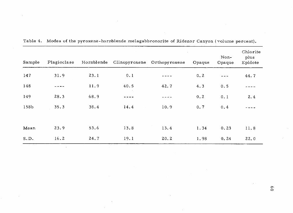
Table 4. Modes of the pyroxene-hornblende melagabbronorite of Ridenor Canyon (volume percent).
ChloriteNon- plus
Sample Plagioclase Hornblende Clinopyroxene Orthopyroxene Opaque Opaque Epidote
147 31.9 23.1 0.1 - - 0.2 44.7
148 11.9 40.5 42.7 4.3 0.5
149 28.3 68.9 - - 0.2 0.1 2.4
158b 35.3 38.4 14.4 10.9 0.7 0.4
Mean 23.9 53.6 13.8 13.4 1.34 0.23 11.8
S.D. 16.2 24.7 19.1 20.2 1.98 0.24 22.0
C

0.5 km
Figure 12. Sample location map of the pyroxene-hornblende melagabbronorite of Rideno Canyon.a-'

62
angles of poorly developed albite twins. Alteration to white mica
and to irregular patches of carbonate and epidote are cornmoi.
Hornblende is commonly brown and shows centers darkened
by clouds of opaque dust. One slide contained scattered aggregates
of anhedral brown hornblende. At the center of every aggregate
are several drop-shaped grains of iron ore. This is the sole
occurrence of iron ore in that slide. Another slide (location 148)
displays poikiolitic olive-green hornblende similar to the late
magmatic hornblende in the gabbronorite of Carney Butte. The
poikiolitic hornblende probably resulted from reaction between the
considerable pyroxene present and all of the plagioclase accounting
for the absence of plagioclase in that thin section.
Augite and hypersthene occur as small, anhedral grains and
are typically ernbayed except in the thin section containing the
poikiolitic hornblende where the pyroxene occurs as rounded grains.
The pyroxenes range from 0.2 to 1.5 mm in size in this slide and
their distribution as discrete grains in the poikiolitic hornblende is
suggestive of a cumulate texture (Figure 13).
Schillar structure is present in the hypersthene only. Other
exsolution features or oriented inclusions were not observed. Augite
alters more readily than the hypersthene to pale green patches of
tremolitefactinolite displaying fuzzy edges and to several grains of
a prismatic chlorite and blue-green hornblende.

Figure 13. Possible cumulate texture of augite and hypersthene inpoikiolitic hornblende. au = augite, hb = hornblende,hy = hypersthene.
63

64
Quartz, apatite, and zircon are very rare. Quartz was
observed as minute interstitial grains in one slide and is presumed
to be primary. One grain of subhedral apatite was found in a coarse-
grained vein of the gabbro, and only two or three grains of anhedral
zircon were found.
Iron ore occurs with small quantities of sulfide except in the
slide containing the poikiolitic hornblende where most of the ore is
a yellow sulfide, probably pyrite, and iron ore is rare. Both iron
ore and sulfide predate or are contemporaneous with the poikiolitic
hornblende, as judged by the absence of ore-filled cracks and
cleavages in the hornblende. Iron ore is associated almost
exclusively with isolated aggregates of brown hornblende in other
slides. In the one slide devoid of pyroxene and containing only
brown hornblende as the primary mafic mineral (location 149), the
iron ore is present as dusty bands in the hornblende. If mobilization
of the iron ore was caused in some way, possibly by later reheating,
the dust-like particles may have coalesced to form the drop-shaped
grains of iron ore seen in several other slides. Rims of hematite
and limonite surround some grains of iron ore.

Quartz-Pyroxene-Hornblende Gabbronoriteof Carney Butte
Field Characteristics
This gabbronorite is exposed throughout a northeast-trending
oval about 18 sq km in size.
The fresh rock is characterized by a medium-grained,
homogeneous texture which gives the rock a granular appearance.
Clear plagioclase and brownish hypersthene are distinctive. Black
hornblende and minor biotite are also present.
The rock is resistant to erosion and forms some of the
highest hills in this part of the Blue Mountains. Outcrops are corn-
i-non and are typically accompanied by piles of huge rounded boulders,
some as large as a house.
Weathering is extensive and in some places readily renders the
granular rock friable for several centimeters. Rust staining is
typical of the weathered rock.
Structures are few. A faint alignment of grains occurs in the
western quarter of the pluton in both hand specimen and in thin
section. The limited distribution of this feature and the absence of
cataclasis suggest that the alignment was caused by primary flow
within the magma. In addition, several xenoliths of a fine-grained,
hornblende-ri.ch rock were noted as well as a few rare veins of
hornblende.
65

66
Areas of brown, siliceous, rock occurs in the NW1 /4. sec.
22, T. 3 S, R. 31 E., andin the NE1/4. sec. 22, T. 3 S., R. 31 E.
These areas are as much as 200 m long and 100 m wide. Several
abandoned test pits were found in this silicified rock, Local people
report several attempts to mine gold in the Carney Butte area but
there are no active mines. The extensively leeched areas appear
similar to large altered xenoliths of meta sediment found in the
Alexander Creek plutoii.
The contact with the gabbro of Alexander Creek is transitional
across approximately 100 rn, There are no obvious features that
serve to define the contact in the field. Therefore, two mineralogical
criteria were used to locate the boundary between the two units: the
presence of hypersthene and the absence of quartz in the gabbronorite.
Contacts with the Columbia River Basalt are exposed in several
localities. A typical example is an outcrop in the NW1/4SW1/4 sec.
21, T. 3 S. , R. 31 E. The contact is sharp and the gabbronorite is
fresh and bears only slight reddish stains adjacent to the contact,
Petrography
This homogeneous pluton is characterized by rocks containing
two pyroxenes and poikiolitic olive.green hornblende. Unlike most
other plutons in the area, cataclasis is absent and alteration is
minimal. The texture is hypidiornorphic granular. Minerals include

67
plagioclase, hornblende, quartz, hypersthene, augite, biotite,
apatite, zircon, and iron ore. Secondary minerals are actinolite,
tremolite, cumrningtonite, chlorite, white mica, hematite, iron
ore, hornblende, and quartz. Most alteration is confined to slide
3l8a; white mica, secondary hornblende, quartz, hematite and iron
ore are the only alteration products in the other slides.
Modes are given in Table 5. Sample locations are indicated
on Figure 14.
Two generations of plagioclase occur: an earlier subhedral
plagioclase (An6248), rectangular and displaying good albite
twinning; and a less common later anhedral sodic plagioclase which
replaces portions of the larger crystals with embayments and
fracture fillings. The plagioclase exhibits occasional oscillatory
zoning. Normal zoning is also faintly visible in some of the earlier
plagioclase crystals. Inclusions of hypersthene, augite, apatite,
and iron ore are found in the central areas of some grains and these
inclusions themselves contain smaller inclusions of iron ore which
probably functioned as nuclei. Rare inclusions of horublende also
occur.
Myrmekite is present along several plagioclase-plagioclase
borders, but no potassium feldspar was noticed, though a minor
amount is probably present.

Table S. Modes of the quartz-pyroxene-hornblende gabbronorite of Carney Butte (volume percent).
aSample 271a is probably a xenolith of the melagabbronorite and is excluded from the mean.
Sample Quartz Plagioclase Biotite Hornblende ClinopyroxeneOrtho-
pyroxene OpaqueNon-
Opaque
265 0.7 61,1 15.7 5.8 14.8 1.6 0.3
267 0.1 67.2 5.4 7.4 16.8 2.8 0.3
270 1,1 62.2 12.8 7.3 14.3 2.1 0.2
27la 44.7 26.3 15.1 13.3 0.8
312 3.9 66.1 17.7 1.3 9.1 1.1 0.8
31 8b 2.5 61,1 24.7 0.3 9.6 1.4 0.5
320 8.4 55.9 3.7 27.1 0.1 3.3 1.1 0.3
327 8.2 S4,1 2.8 28.2 0.5 5.2 0.9 0.2
345 4.9 58.0 18.3 3.9 13.0 1.7 0.2
356 2.2 68.2 13.1 3.0 12.5 0.9 0.1
Me an 3.6 61.5 0.72 18.1 3.3 11.0 1.5 0.33
S.D. 3.1 5.0 1.45 7.4 3.0 4.5 0.53 0.19

318
1 km
Figure 14, Sample location map of the quartz-pyroxene-hornblende gabbronorite of Carney Butte.Diagonally ruled areas are Columbia River Basalt.

70
Hypersthene is strongly pleochroic from red to green. Some
grains display schillar structure parallel to {l00}and represent
exsolved Carich clinopyroxene (Figure 15) (Deer and others, 1963).
Parallel to the schillar in some grains are thin opaque rods. Per-
pendicular to these and parallel to {00l } are short, stubby, brown
laths (Figure 16). They are translucent but show no birefringence
and ftey occur in the augite also, parallel to {ooi}. Alteration of
hypersthene is minimal, but where present it occurs as a thin rim
of colorless amphibole (Figure 17), probably cummingtonite, or is
rimmed by a thin band of blue-green hornblende.
The augite is characterized by a pale green color. It contains
small inclusions of ore and exhibits occasional schillar which is
probably exsolved orthopyroxene. Twinning is common but herring-
bone structure was not observed. Borders among augite, hypersthene,
and plagioclase show no reaction and apparently are in equilibrium.
Alteration of the augite to hornblende is more pronounced than that
of hypersthene, but is still slight. The augite is variously replaced
by a pleochroic blue-green hornblende containing vermicular
inclusions of quartz.
The poikiolitic hornblende is typically olive green in color.
Long fingers of this mineral between grains of plagioclase, quartz,
and pyroxene indicate that the hornblende crystallized late, post-
dating quartz (Figure 18). Only the rare large flakes of biotite

Figure 15. Hypersthene showing schiller. au = augite, hy = hyper-sthene, hb = hornblende, io = iron ore, p1 = plagioclase.
Figure 16. Exsolution in hypersthene. Symbols same as above.
71

72
Figure 17. i-iypersthene rimmed by colorless cummingtonite transi-tional into hornblende. bi = biotite, hb = hornblende,hy = hy-persthene, io = iron ore, p1 = plagioclase,q = quartz.
Figure 18. Poikiolitic hornblende interstitial to all grains. Symbolssame as above.

73
postdate the hornblende. The amount of hornblende is not evenly
distributed throughout the rock, but bears a strong inverse relation-
ship to the amount of augite present and a less strong inverse cor-
relation to the amount of hypersthene. The hornblende is also more
abundant near the contact with the Alexander Creek rock. (See Table
5 and Figure 14.) These facts suggest that the poikiolitic hornblende
may have resulted through the conversion of augite and lesser amounts
of hypersthene by late magmatic solutions and that these solutions,
though probably indigenous to the gabbronorite, acquired heat and
mobility from the closely succeeding intrusion of the gabbro of
Alexander Creek. Because the hornblende freely penetrates around
grains, the gabbronorite, though consolidated, was still hot at the
time the hornblende crystallized.
Large irregular globules of iron ore accompany the hornblende
and are probably derived from the iron contained in the pyroxenes.
Areas of clear amphibole are commonly present around pyroxenes
at localities 320 and 327 but are rare in other slides. The clear
amphibole is probably tremolite where it surrounds augite and
cummingtonite where it rims the hypersthene. Both amphiboles are
intimately related to the hornblende and formed simultaneously with
it. The simultaneous formation of these clear amphiboles with the
associated hornblende is indicated by the simultaneous extinction of
distince areas of clear amphibole around separated and differently

74
oriented pyroxene grains included within one optically continuous
hornblende. Furthermore, where the clear amphibole surrounds a
single grain of pyroxene and is bordered by two or more grains of
hornblende, the clear amphibole extinguishes at different positions.
Rare large flakes of brown biotite are restricted to localities
318, 320 and 327, also the locations of the most abundant amounts
of clear amphibole. The biotite typically rims the green magmatic
hornblende. This occurrence of biotite may indicate the presence
of water and late-stage volatiles in more than usual amounts and
persisting lower temperatures.
Quartz is clear, unstained, and interstitial. Occasional dust
trails are the only inclusions. Grains are optically continuous though
separated by several millimeters. This suggests a quiescent environ-
ment at the time of crystallization.
Apatite is euhedral and commonly borders and is included in
the mafic minerals and more rarely in plagioclase. Most of the
apatite is colorless, though several grains of colored apatite
similar to that in the hornblendite were found.
Some iron ore precipitated early and served as nuclei for
apatite and pyroxene. A later crystallization of iron ore is associated
with the poikiolitic hornblende and is distinguished by its larger size
and interstitial character to pyroxene and plagioclase. Small
amounts of a yellow sulfide are intermixed with some of the iron ore.

75
Slide 271a is atypical of the pluton and may be a xenolith. The
hornblende in this slide is brown, nonpoikiolotic and in discrete
grains that replace scattered large crystals of both pyroxenes,
especially augite. The irregular shapes of the pyroxenes suggest
resorption and the fine r-grained, allotromorphic texture may indi-
cate recrystallization caused by later reheating. Both texture and
mineralogy are similar to portions of the melagabbronorite of
Ridenor Canyon.
Biotite -bearing, Quartz-Hornblende Gabbro of Alexander Creek
Field Characteristics
Exposures of this unit form an arcuate shaped area 0. 3 to 1
km wide. The gabbro forms the south, west, and northeast bound-
aries of the gabbronorite of Carney Butte and separates that unit
from the metasedimentary country rock. The total areal extent of
the gabbro is about 8 sq km.
The rock is variable. The fresh rock is typically medium or
coarse grained and contains black, stubby hornblende, white plagio-
clase, quartz, and scattered flakes of brown biotite. Near the
metasediment the rock is well foliated and contains l3ths of green
hornblende, white plagioclase, 10 to 15 percent quartz, and large
scattered flakes of brown biotite up to 1 cm across. As the rock

76
approaches the gabbronorite, the gabbro becomes progressively
medium grained, unfoliated, homogeneous and contains black horn-
blende, gray to clear plagioclase, small rare flakes of brown biotite
and 5 percent or less of quartz. Small brown grains of hypersthene
eventually appear and the quartz disappears marking the transition
from gabbro to gabbronorite.
Outcrops are rare and confined to road cuts and to the steep
slopes along Alexander and Snipe Creeks. The rock is intensely
weathered and commonly is very friable even to a depth of several
meters. The weathering bleaches the brown biotite, whitens the
plagioclase and disintegrates the hornblende. Boulders sometimes
develop a pink-colored rind several inches thick.
A well- to poorly-developed foliation occurs near the outer
border of the unit and is parallel to the outer margin in places.
Oriented xenoliths of hornfelsed country rock are common (Figure
19). Xenoliths of hornblendite were also observed (Figure 20). Other
xenoliths are exposed in road cuts along Highway 395 and appear as
brown, somewhat silicified rocks having a partially obscured foliation.
Additional intensely leeched and silicified areas occur in the Sl/4.
sec. 30, T. 3 S., R. 31 E. where the xenoliths form ridges several
feet high and 50 feet long. The ridges trend within 20 degrees of
north and rare streaks of biotite indicate a nearly vertical attitude.
These seem to be xenoliths of metasediment, but several slickensides

Figure 19. Oriented xenoliths (arrows) in the biotite-bearing, quartz-hornblende gabbro of Alexander Creek.
Figure 20. Xenolith of hornblendite in the Alexander Creek pluton.
77

78
and the presence of angular clasts in portions of the rock introdiice
the possibility that the ridges may be silicified fault zones.
Several pegrnatites are scattered throughout the unit and
contain quartz, white feldspar, muscovite books, black tourmaline,
and clear red garnets 5 mm in diameter. One of the largest of the
pegmatites is in the NE1/4SE1/4 sec. 14, T. 3 S., R. 31 E., at
the site of an abandoned uranium prospect. The pegrnatite is at
least 1 m wide although the lower contact is concealed. Several
hornblende-rich xenoliths, encircled by one or two halos of horn-
blende, were found at the pegmatite locality.
Contacts with adjacent units are exposed in several places.
The contact with the gabbronorite is gradational. Contacts with the
metasedimentary rocks are transitional for as much as 100 m and
are accompanied by numerous injections of the gabbro along planes
of foliation. The contact with the overlying Columbia River Basalt
is well exposed in a road cut along Highway 395, about 2 km north of
Battle Mountain State Park. This contact displays a reddish baked
zone about 0. 6 rn wide in the intensely weathered quartz gabbro
(Figure 21).
Petrog raphy
The three representative thin sections of rocks from this
heterogeneous pluton come from within 0. 5 km of the gabbronorite

Figure 21. Contact between the Columbia River Basalt and theAlexander Creek pluton showing a reddish baked zone.
79

80
of Carney Butte. All are characterized by a coarse-grained,hypidio-
rnorphic-granular texture, scattered brown biotite, and blue .green
hornblende. Cataclasis is absent from these three slides though
alignment of grains and undulatory extinction in quartz are common
near the outer margins of the pluton. Minerals include plagioclase,
hornblende, quartz, biotite, augite, apatite, zircon and iron ore with
alteration products of white mica, epidote, clinozoisite, chlorite,
hematite and limonite. Modes are given in Table 6; sample locations
are in Figure 22.
The plagioclase (An54 is very similar to that in the adjacent
gabbronorite of Carney Butte although less calcic in composition.
The same rectangular subhedral shape, well-developed albite twins,
faint normal and oscillatory zoning and general size are striking.
The later, more sic, plagioclase seems to be missing, however.
Thin sections from areas of numerous xenoliths, which includes
most of the pluton, contain plagioclase that is distinct in several ways
from the Irepresentative!! plagioclase: 1) the grains are smaller
and anhedral instead of subhedral; 2) patchy extinction and sodic
rims are pronounced; 3) the anorthite molecule is more abundant
and ranges from An75 59; 4) the grains are slightly aligned. In
addition, the large flakes of primary biotite are absent, though small,
secondary biotite appears along cleavages in hornblende.

Table 6. Modes of the biotite-bearing, quartz-hornblende gabbro of Alexander Creek (volumepercent).
aSamples 264b, 277a, 293a, and 316 are from areas containing abundant xenoliths and representcontamination of the gabbro. Samples 247 and 288 are border phases of the gabbro. All six samplesare excluded from the mean.
Sample Quartz Plagioclase Biotite Hornblende OpaqueNon-
Opaque
Chloriteplus
Epidote
a247 22.1 --- 79.6 0.9 0.1
260a 10.5 47.3 5.7 35.7 0.3 0.1 0.3
264b ---- 48.1 0.1 46.7 4.6 0.4 0.1
277a 0.1 53.3 0.3 41.9 4.1 0.2 -
288 ---- 37. 3 - 58.7 3. 7 0. 3 -
293a 0.1 71.0 --- 25.5 3.1 0.3 -
316 ---- 18.5 - 79.3 1.4 - 0.8
343 12.4 53.8 7.9 24.8 0.8 0.4 0.3
357a 15.7 50. 1 4. 7 28.2 0.6 0.4 -
Mean 12.9 50.4 6.1 29.6 0.58 0.29 0.19
S.D. 2.6 3.3 1.6 5.6 0.24 0.15 0.16

rnple locatbbronoritever Basalt
Figure 22. Sa ion map of the Alexander Creek pluton. Diagonally ruled areas representga (purple), metagabbro (green), hornblendite (light green), and ColumbiaRi uncolored). N)

83
Biotite is pie ochroic light brown to reddish brown in slide 357a,
but is dark brown to light brown in slide 260a. The reddish brown
pleochroism may represent more titanium in the biotite structure
(Deer and others, 1963). A slightly higher titanium content at 357a
is in accord with the chemical data. (See Table 8 .) Alterations to
spindles of a clear mineral (epidote or clinozoisite) are scattered
along cleavage planes in the biotite. Some chlorite is also present,
but no sphene was observed.
Hornblende is green or blue-green. The blue-green color is
especially apparent near grain boundaries indicating a slight zoning
of the hornblende. Some grains exhibit centers of colorless amphibole
that contain vermicular inclusions of quartz (Figure 23) derived from
former pyroxenes (Taubeneck, 1964b). Near the gabbronorite the
hornblende is poikiolitic but occurs as discrete grains farther away.
Quartz is also interstitial and similar to the lucid quartz in
the gabbronorite. Slight undulatory extinction in some grains marks
ne difference, however.
Apatite is clear and euhedral. Generally it occurs as
inclusions in biotite or hornblende, but it is also common in plagio-
clase and quartz.
Iron ore is intermixed with a yellow sulfide, probably pyrite.
The sulfide is much less abundant than the iron ore, but is present

84
Figure 23. Vermicular inclusions of quartz th hornblende indicatingthe former presence of pyroxene.

85
in all thin sections. The irregular shape is similar to that in the
gabbronorite and suggests a similar mode of origin.
Zircon is rare; only euhedral or subhedral grains were noted.
The mineralogy and texture of the gabbro are similar to that
of the adjacent gabbronorite though the quartz gabbro is coarser
grained and is significantly more felsic. The greatest similarity
between the two intrusions is apparent in the rocks along their com-
mon contact. As the outer margin is approached, effects of flow are
apparent in the alignment of grains and, the abundance of xenoliths,
notably of hornblendite and metagabbro. Reaction with and partial
assimilation of these xenoliths by deuteric solutions might be one
explanation for the patchy extinction in the plagioclase, the absence
of quartz, and the sodic rims of plagioclase that are typical of this
outer portion of the pluton.
Hornblende Trondhjemite of Johnson Creek
Field Characteristics
Outcrops of this intrusive occur mostly within a square-shaped
area of 0.6 sq km in the NWl/4 sec. 26, T. 2 S., R. 32 E.
The rock is homogeneous, medium grained, and light colored.
The light color results from less than 10 percent black hornblende
and brown biotite and from more than 90 percent white plagioclase

86
and quartz. Weathering imparts a light rust stain around the rnafic
minerals.
Outcrops are common and accompanied by huge round boulders.
Foliation is weak to absent. A number of xenoliths of the
hornblende -gneiss and the quartz-hornblende gabbro are present,
and three are large enough to be mapped. (See Figure 24.)
Contacts are concealed except along the border with the meta-
tonalite of California Gulch. This contact is exposed in a road cut
and appears as a zone of brown silicified rock about 0. 5 rn wide.
The older foliated rock of California Gulch is intensely altered, and
details of the contact are obscured. The contact with the adjoining
quartz-hornblende metagabbro is not exposed, but several small
dikes, apparently from the trondhjernite, penetrate the quartz-
hornblende metagabbro near the contact.
Petrography
Less than 10 percent mafic minerals and well-developed
oscillatory zoning in plagioclase distinguish the rocks of this pluton.
Minerals include plagioclase, hornblende, quartz, biotite, apatite,
zircon and iron ore. Alteration products are white mica, epidote,
clinozoisite, chlorite, and hematite. Modal data for one specimen
revealed 66. 0 percent plagioclase, 22. 5 percent quartz, 5. 6 percent
hornblende, 1.2 percent biotite, 0.60 percent opaques, 0.20 percent

87
Figure 24. Sample location map of the Johnson Creek pluton.Diagonally ruled areas represent Columbia River Basalt(uncolored) and hornblende gneiss (gray).

88
nonopaques, and 3. 6 percent chlorite plus epidote. The sample
location is shown in Figure 24. The texture is hypidiomorphic
granular and is distinguished by late stage cataclasis showing the
development of mortar texture.
Plagioclase occurs as large subhedral grains averaging 1 by
2 or 3 mm. Albite and pericline twins are common and give An45
as the percent anorthite. The twins are kinked and displaced in
some grains. The fractures are rehealed by plagioclase testifying
to the high temperature at the time of strain. Oscillatory zoning is
pronounced. More than 20 zones were counted in several grains.
Some zones are concentric about one, two or even three nuclei. The
centers display typically euhedral outlines (Figure 25). The nuclei
are defined by alteration to white mica, epidote and clinozoisite.
Sericitic alteration commonly defines one or two zones outward from
the center leaving the remaining zones to be detected by differences
in extinction positions. A few grains display several of these altered
bands, but a simultaneous extinction gives no indication of additional
zones. Presumably equilibration has occurred among the zones, but
the cause is not known.
Thin bands of oblong quartz crystals surround the plagioclase.
Larger quartz grains separate the plagioclase. Sutured borders
with other quartz grains and pronounced undulatory extinction
suggest that little recrystallization has taken place since cataclasis.

Figure 25. Oscillatory zoning in plagioclase in the hornblendetrondhjemite of Johnson Creek.
89

90
Hornblende is blue green, subhedral, and is terminated by
ragged edges, though euhedral inclusions occur in plagioclase. Iron
ore and euhedral apatite are present as inclusions in the hornblende.
Yellow epidote and chlorite are alteration products.
Strings of biotite weave in and out among the hornblende. All
crystals of biotite are partly altered to chlorite, epidote and a clear
mineral, possibly clinozoisite. The freshest biotite is a ltdirtyt!
greenish brown and has a ragged texture.
Euhedral zircon and apatite are common and are typically
associated with biotite, hornblende, and iron ore. Euhedral zircon
appears as inclusions in at least two apatite grains where the zircon
probably functioned as nuclei.
Primary iron ore is present as subhedral grains as much as
0. 5 mm in diameter. Secondary iron ore occurs along cleavage
planes in chlorite that has formed from biotite,
Granodiorite of Table Mountain
Field Characteristics
The exposure of this intrusive is confined to one low outcrop in
the NWl/4SWl/4 sec. 15, T. 3 S., R. 32 E. Additional information
as to the extent of this pluton is provided by float and intrusion of the

91
rock into the adjacent metavolcanic unit to the north. The total areal
extent is about 0. 2 sq km.
The fresh rock is light in color and consists mainly of white
plagioclase and lesser amounts of quartz. Biotite is the only obvious
mafic mineral, though hornblende is present in dikes that intrude the
hornbiende-rich meta.volcanjc unit. Mafic minerals total less than
10 percent of the rock.
The granodiorite is medium grained and slightly foliated in a
northwesterly direction. A faint compositional banding is parallel
to the foliation. Both structures are presumed to be local border
features of the pluton.
Only the contact with the metavolcanic unit is exposed. This
contact is marked by an abrupt termination of the prominent cliffs
of the metavolcanic unit and the beginning of a smooth slope devoid
of outcrops. At the edges of the cliffs many small straight and
irregular1y shaped unfoliated dikes of the granodiorite intrude the
metavolcanic rock and assimilate portions of it. Because the dikes
are unfoliated and cut across foliatiOn, the granodiorite postdates
the metamorphism of the metavolcanic unit.

Petrography
This is the only pluton that contains significant amounts of
potassium feldspar. The rock is further distinguished by the virtual
absence of iron ore, the absence of hornblende, and the presence of
significant amounts of muscovite.
A well-developed lepidoblastic texture accompanied by mortar
texture is visible around plagioclase and quartz. The slight cataclasis
is attributed to flowage of the magma near the margin. Smooth
grain boundaries of some smaller grains indicate partial recrystal-
lization.
Plagioclase, orthoclase, quartz, biotite, muscovite, apatite,
zircon, garnet, and iron ore are present with secondary alterations
to white mica, epidote, and hematite. Modes are presented in
Table 7; sample locations in Plate 1.
Plagiociase is present as large subrectangular grains that have
been abraded and partially aligned, and as small partially recrystal-
lized fragments of larger grains. The larger crystals exhibit
pronounced sodic rims and some show faint oscillatory zoning in
several rather wide bands. The smaller grains are unzoned. Calcic
cores are sharply defined by moderate alteration to scattered flakes
of white mica and plumes of pleochroic yellow epidote. Twinning is
rare and poorly developed. Only albite and carlsbad twins were noted
92

Table 7. Modes of the granodiorite of Table Mountain (volume percent).
Potassium Non-Sample feldspar Quartz Plagioclase Biotite Muscovite Opaque Opaque
136 6.3 46.2 41.0 3.3 2.9 0.1 0.1
l36a 2.3 52.0 41.0 2.0 2.6 0.1
Mean 4.33 49.1 41.0 2.66 2.75 0.05 0.1
S.D. 2.83 4.1 00.0 0.93 0.28 0.07 0.0

94
and are equally abundant. Anorthite composition was not determined
owing to the poorly developed twinning. The refractive index is
greater than that of quartz and the plagioclase is probably a calcic
oligoclase or an andesine.
Like plagioclase, orthoclase is also present as both large and
small grains. The large grains are about the same size (0. 5 by 1. 0
mm) as the plagioclase grains and show exsolution lamella of albite
under high power at the extinction position. One grain shows a faint
microcline grid. The small grains are interstitial to plagioclase and
quartz and react with plagioclase to form abundant myrmekite
(Figure 26).
Aligned flakes of muscovite and biotite are pressed between
and partially around larger grains of quartz and feldspar. The biotite
is pleochroic dark brown to light yellowish brown and in places is
intergrown with muscovite. Chlorite is absent. Inclusions of
euhedral zircon faintly color the micas.
Quartz occurs as clear, clean anhedral grains and exhibits
simultaneous extinction. Grains are typically oblong and present in
aggregates elongated in the direction of foliation. The fact that the
quartz is unstrained and yet occurs in a texture that was formed by
cataclasis indicates that it has undergone recrystallization. Quartz-
quartz boundaries are straight, but the presence of only a few triple

95
Figure 26. Myrmekite penetrating a large grain of potassium feld-spar in the granodiorite of Table Mountain.

96
junctions indicates that an equilibrium texture was not fully attained
(Spry, 1969).
Zircon is scarce. Grains are minute and either euhedral or
subhedral. They are most common as inclusions in laths of mica.
Apatite and iron ore are rare. Only three grains of subhedral
apatite were observed, and only two occurrences of iron ore. Both
minerals are associated with biotite. All other opaques are bright
red in reflected light indicating hematite. Most of the hematite
occurs in or along cleavage planes in the mica and is probably an
alteration of the iron ore.
One grain of garnet was found. It is about 0. 3 mm in diameter
and deeply embayed indicating formation under earlier, more stable
conditions.
Petrography of a Trondhjemite Dike
A trondjemite dike is partially exposed at location 297 (Plate 1)
where it has intruded the pelitic metasedimentary unit. The presence
of garnet and sillimanite testify to its reaction with the pelitic country
rock. A similar but not identical mineralogy suggests that the dike
may be an offshoot of the granodiorite of Table Mountain, about 5 km
to the southeast. In addition to garnet and sillimanite, quartz, plagio-
clase, biotite, zircon, white mica, hematite and iron ore were
observed. No potassium feldspar or hornblende was found. A modal

97
analysis revealed 68.8 percent plagioclase, 25.4 percent quartz,
4. 60 percent biotite, 0. 99 percent muscovite and garnet, 0. 27 percent
iron ore, and 0. 20 percent chlorite plus epidote.
Plagioclase displays both progressive normal and oscillatory
zoning. Extinction angles on albite twins give a composition of
andesine (An47), but refractive indices less than that of quartz
indicate albite or oligioclase margins. Minor alteration to white
mica occurs.
Grains of quartz are anhedral and show irregular quartz-
quartz boundaries. Undulatory extinction is rare, however, and
suggests that the quartz has undergone partial recrystallization.
Biotite is strongly pleochroic light brown to a deep reddish
brown. Crystals reach a maximum length of 0. 5 mm and appear to
be randomly oriented though a slight alignment is present in grains
of plagioclase. Fingers of green biotite are intergrown with the
brown biotite and represent alteration of brown biotite. Small
grains of iron ore are common in the green biotite.
Muscovite is typically embayed by quartz and in places exhibits
a gradual transformation to brown needles of sillimanite. Small
round garnets, no larger than 0. 5 mm in diameter, are also
associated with the sillimanite. Sillimanite mantles several of the
garnets.

98
Zircon is rare. Only three euhedral grains were found. Iron
ore is also rare and occurs as minute irregular grains.

CENOZOIC UNITS
Eocene Strata
Field Characteristics
This series of interbedded flows, sediments, and sills crops
out in the northeast part of the thesis area, principally along East
Birch Creek. The rocks are unmetamorphosed, overlie the pre-
Teriary igneous and metamorphic complex, and form an angular
unconformity with the overlying Columbia River Basalt. An early
or middle Eocene age has been established for these rocks on the
basis of leaf fossils (Wolfe, written communication, 1975). The
vertical section of the unit in this area is estimated to be about
420 m (1400 ft) (Pigg, 1961, p. 24). The total areal exposure is
about 5 sq km. This unit was referred to as the Clarno Formation
by Mendenhall (1909).
The unit consists of four major rock types: ande site porphyry,
porphyritic rhyolite, dacite porphyry (Hogenson, 1956; Pigg 1961),
and a sedimentary series ranging from carbonaceous shale to coarse-
grained arkose. A small mafic sill constitutes an additional but
minor fifth rock type.
The poor exposure and limited extent of the various rock types
prevented them from being individually mapped though a stratigraphic
99

column where best exposed at location 66 (Plate 1) is shown in
Figure 27.
Andesite Porphyry
Field Characteristics
The most widespread and common rock type is the andesite
porphyry. The porphyry extends from East Birch Creek where it
forms three distinct flows from 15 to 24 m thick to Stanley Creek
where it occurs as thin isolated exposures on the metatonalite of
California Gulch.
The rock is characterized by clear, rounded, quartz pheno-
crysts averaging about 1 cm in diameter and by white rectangular
feldspar up to 0. 8 by 1 cm. Smaller laths of black hornblende and
rare books of biotite several millimeters across are set in the
aphanitic groundmass. The fresh rock is a bluish gray, but
weathers readily to an orange to brown color. The quartz pheno-
crysts weather out and are abundant in the tilled fields and soil of
the area.
Vesicules and flow alignment are absent.
Petro raphy
Large subhedral quartz phenocrysts as much as 1 cm in
100

Columbia River Basalt
Andesite porphyry; brownish-gray; moderately weatheredand easily eroded.
Arkose; reddish-brown; medium-grained; thick bedded.
101
Figure 27. Stratigraphic column of Eocene rocks along East BirchCreek at location 66.
0
Porphyritic rhyolite (?);brown; moderately weathered;brittle and siliceous; formscliffs.
Andesite porphyry; gray;moderately weathered;forms cliffs.
Arkose; fine-grained at toptransitional into gray shaleand micaceous mudstone atbott om.
Andesite porphyry; bluish-gray;forms cliffs.
'0
V
0
0
#
U
U
_o.
El /ci

102
diameter are the distinguishing feature of the three flows. Quartz
is the only mineral retaining a fresh appearance in this extensively
altered rock (Figure 28). Large euhedral pherocrysts of twinned
plagioclase as much as 1 cm long, biotite up to 2 or 3 mm long
and rare hornblende are also present. Additional primary minerals
include apatite, zircon, an iron ore. Secondary minerals are
epidote, chlorite, sphene, leucoxene, white mica, carbonate,
hematite, limonite, and iron ore. The estimated abundance of
phenocrysts in the three slides examined ranges from 30 to 40 per
cent. Of this about 4 percent is quartz, 25 percent is plagioclase,
and 5 percent is biotite, making the rock an ande site porphyry
according to the classification of Travis (1955). However, because
the phenocrysts of quartz are so large a small increase in their
abundance would require reclassification to a dacite porphyry.
Although all of the thin sections examined revealed andesite porphyry,
dacitic flows are likely, and have been recorded by Hogenson (1956)
and Pigg (1961).
Phenocrysts are randomly oriented and set in an holocrystalline
groundmass. Location numbers for the three thin sections are 66
and 177 and are shown on Plate 1.
Plagioclase phenocrysts are almost entirely converted to
carbonate and white mica. Carbonate replaces over 50 percent of
many plagioclase crystals. The freshest sections display

Figure 28. Texture of the andesite porphyry showing intensealteration. bi=biotite, cacarbonate,plplagioclase, q=quartz.
103

104
spectacular oscillatory zoning. At least 60 delicate bands were
counted in one grain and about 50 in another.
Quartz is clear and unstrained. Although subhedral, several
long, narrow embayments appear in a few crystals and are filled
by the aphanitic groundmass. The only unaltered primary minerals
besides quartz appear as inclusions within the quartz where they
were protected from hydrothermal solutions. The inclusions are of
reddish brown biotite and of euhedral magnetite.
Biotite phenocrysts are typically altered to a mixture of
chlorite, carbonate, and white mica. Sphene and associated
leucoxene form bulges in the cleavage planes. Some grains are
converted entirely to white mica. Rarely, a dark brown pleochroism
is visible in the least altered grains. Numerous inclusions of
apatite and long, slender euhedral zircon occur. Zircon causes
distinctively visible pleochroic halos in mica.
Several elongate, euhedral pseudomorphs up to 3 mm long
and suggestive of the shape of hornblende were noticed, but are so
completely replaced by chlorite and carbonate that original cleavage
is obscured and positive identification is impossible. The presence
of rare laths of black hornblende in hand specimen suggests that
the pseudomorphs are probably hornblende.
Apatite is present as large subhedral grains up to 0. 5 mm
long. Iron ore is rare. Most has been converted to limonite or

leucoxene suggesting the occurrence of titaniferous magnetite.
Groundmass consists of plagioclase, quartz and scattered
grains of mica now completely converted to chlorite. The small
grain size of the groundmass, approximately 0. 03 mm, prevents
the notation of further detail.
Porphyritic Rhyolite
Field Characteristics
The best exposures of the porphyritic rhyolite occur on the
north side of East Birch Creek where it forms cliffs 9 to 12 m high
as part of a flow about 35 m thick (Figure 29). The rhyolite may
extend for about 2 km south of East Birch Creek, but its typically
altered character prevents positive identification.
The rock is characterized by small, round quartz grains about
1 to 2 mm in diameter and by phenocrysts of pink feldspar averaging
about 3 mm in diameter. Both the size and the abundance of the
phenocrysts are less than in the ande site porphyry. The pheno-
crysts are set in a siliceous, aphanitic groundmass that is most
often an orange-brown color. Mafic minerals are rare or absent.
The rock is usually so intensely altered that the texture is
obliterated except for the quartz phenocrysts.
No thin sections were examined so positive identification is
105

impossible, but Pigg (1961) cites the occurrence of porphyritic
rhyolite along the north side of East Birch Creek.
Sedimentary Strata
Field Characteristics
The sedimentary strata are exposed only in the northeast part
of the area and in several isolated outcrops along Pearson Creek.
The rock varies from black, fossiliferous, carbonaceous
shales, to gray mudstones and siltstones, to a light buff-to-brown,
medium-grained arkose which is the dominant lithology. The
arkose is characterized by numerous flakes of biotite, feldspar,
quartz, and black, siliceous lithic clasts all set in less than 10
percent siliceous matrix, cemented by silica.
Leaf fossils were collected from two localities and were
identified by Jack Wolfe of the United States Geological Survey at
Menlo Park. The fossils include:
Location 41: SW1/4SE1/4, sec. 30, T. 25., R. 33 E.,from a shale bed on the west side of Pearson Creek.
Anemia eocenica of Wolfe, 1968Glytostrobus sp.Sapindaceae, gen. indet.
106

Location 45: NEl/4SW1/4 sec. 19, T. 2 S., R. 33 E.,from silt and shale beds on the east side ofPearson Creek.
Anemia eocenica of Wolfe, 1968bus sp.
Alnus operia MacG,Vitis sp.
Species elsewhere in this area include (Hogenson, 1956):
Location: NW1/4NE1/4. sec. 12, T. ZS., R. 32E,, froma shale bed in the north wall of East Birch Creekcanyon.
erosa (Lesquereux) Knowltonand MaxonLastrea fischeri HeerEquisetum sp.Glyptostrobus dakotensis BrownSabalites sp.Betula sp.Quercus banksiaefolia NewberryNumerous other dictyledonous leaves.
Location: NE1/4NW1/4 sec. 31, T. 2 S., R. 33 E., from ashale bed on the west bank of Pearson Creek.
Aneimia sp.Lastrea fischeri HeerGlyptostrobus dakotensis BrownNumerous dicotyledonous leaves.
Anemia and Alnus occur in the lower Ravenian of the Puget
Group (late middle Eocene age), but both species also occur in the
lower Eocene. Sapindaceae occurs in the Roslyn Formation
(Fultonian Stage, i. e., early middle Eocene). The Pearson Creek
beds are thus of early or middle Eocene age. The assemblages
from the Clarno Formation near Mitchell, which are from the lower
107

108
part of the unit, represent both the Fultonian and lower Ravenian,
and it is possible that the Pearson Creek hlClarnou is equivalent
in age to the lower Clarno near Mitchell (Wolfe, written communica-
tion, 1975).
Other structures include rare cross-bedding that resembles
foreset beds. The cross-bedding is displayed on several low out-
crops of arkose that occur in the SE1/4SW1/4, sec. 13, T. 2 S.,
R. 32 E. (See Figure 30. ) An easterly source is indicated.
Slickensides were observed in several places, particularly in
a road cut in the SW1/4SW1/4. sec. 7, T. 2 S., R. 33 E. where
striations plunge approximately 25 degrees in a east-northeasterly
direction on a slickensided surface. Although fault gouge was not
found, several small fragments of gray mudstone appear as xeno-
liths in the arkose, and several of these are offset slightly. Quartz
veins cut the arkose and are unique to this locality.
Contacts between the sediments and the flows are generally
concealed, but where exposed they are sharp and exhibit a darkened
baked zone extending into the sediment for approximately 0. 5 m.
Petrography
The arkose is medium grained and appears rather clean in
thin section. About 7 percent matrix is present and consists of iron
ore and abundant limonite. Silica is the cementing agent. Minerals

Figure Z9 Outcrop pattern of rhyolitic and andesitic flowsalong East Birch Creek.
Figure 30. Truncated cross-bedding resembling foreset bedsin the arkose.
109

110
include plagioclase, quartz, potas sium feldspar, biotite, muscovite,
apatite, zircon, and garnet. Additional minerals reported by Pigg
(1961) include sillimanite, fluorite, monazite, staurolite, chlorite,
melillite, enstatite, hornblende, and andalusite. Chert and lithic
clasts also occur. The sample location, 66, is indicated on Plate 1.
Because only one thin section was examined, results probably
are not representative though the arkose is widespread and relatively
homogeneous.
None of the Z0 percent or so plagioclase grains shows
oscillatory zoning. Faint normal zoning was detected in less than
five grains. Alteration to white mica is moderate to extreme, and
pronounced patchy extinction is visible in some grains.
Most of the quartz shows simultaneous extinction, but in
some grains the extinction is undulatory. The clasts are angular
and visual estimates rate the average sphericity of the quartz
grains at 0. 7 and the roundness at 0. 3 (Figure 31) (Krumbein and
Sloss, 1963). Quartz comprises about 55 percent of the rock.
Potassium feldspar is present in amount of 5 percent or less. Some
grains are microperthite under high magnification and other grains
show a faint microcline grid (Figure 32), making the mineral
microperthitic microcline.
Muscovite amounts to 1 to 2 percent in grains up to 1 mm
long. Biotite is less common and is extensively altered. Several

111
small angular fragments of garnet were observed as were several
apatite grains. Two grains of a smokey-green mineral may also
be apatite. Euhedral zircons occur in quartz and larger, rounded
zircons are present as discrete grains. Lithic clasts comprise
about 8 percent of the rock. The clasts are dominantly quartz with
lesser amounts of plagioclase and muscovite. A strong foliation is
commonly present in the clasts.
The general mineralogy siggests an igneous or, more likely,
a metamorphic source terrain. The presence of staurolite in the
metasediment is the only reported in situ occurrence of staurolite
in northeastern Oregon (Taubeneck, oral communication, 1975),
and its presence in the arkose strongly suggests that the staurolite
was locally derived.
Mafic Sill
Field Characteristics
A sill about 6 m thick is exposed for 0. 4kminthe NE1/4NEl/4
sec. 23, T. 2 S., R. 32 E. The sill is intruded between a siliceous
volcanic rock, probably the porphyritic rhyolite and the overlying
arkose which is baked to a dark brown next to the contact. The
sill forms cliffs 2 m high, but is very brittle and crumbles readily
along numerous fractures and along planes of flow. The rock is

Figure 31 Angular quartz grains inarkose. Symbolsare defined below.
Figure 32. Texture of arkoe. ch=chert, mi=microcline,mu=muscovite, pl=plagioclase, q=quartz.
112

113
characterized by a black almost carbonaceous appearance and by
ovoids up to 0. 5 by 1. 5 cm elongated parallel to the contacts of the
sill. The elongate structures are composed of the same material
as the rest of the sill and are distinguishable because they easily
weather out of the rock and may be a feature caused by weathering.
The rock is completely aphyric and no grains are large enough to
be identified with a hand lens except scattered grains of a sulfide
mineral, probably pyrite.
Petrography
Pronounced flow banding and a unique orbicular structure
make this sill distinctive. The orbicular structure is the result of
ovoids of a brownish, nonbirefringent mineral which may be
chlorophaeite. Virtually the entire rock is composed of the same
brownish mineral. The ovoids vary considerably in size and are
strongly elongated parallel to the flow banding. Several concentric
brown rings are present in many of the ovoids but nonconcentric
rings also appear. Angular fragments of sulfide, biotite, and
clear areas of silica are included within the ovoids. Aggregates of
minute grains of iron ore are visible in some of the ovoids and also
appear along intervening shear planes. A typical ovoid is pictured
in Figure 33. The sample location is 87, shown on Plate 1.
The angular biotite included in the ovoids is pleochroic dark


115
brown; birefringence is masked by the strong coloration of the
mineral. The biotite has a maximum length of about 3 mm.
Transparent areas were identified under high magnification as
aggregates of either crystobalite or trydimite. Set among these
clear aggregates are usually one or two larger crystals of euhedral
green epidote, some as long as 0. 3 mm.
White mica, unidentified scattered grains, possibly of former
feldspar, and rare grains of zircon complete the list of minerals
identified.
Columbia River Basalt
Field Characteristics
The approximately 192 sq km of exposure make the Columbia
River Basalt by far the most extensive unit in the thesis area.
The basalt surrounds all of the older rocks except at the west border
of the thesis area where the metasedimentary unit continues west-
ward, In addition, several small outliers of basalt, less than 30 m
thick, rest on the gabbronorite of Carney Butte. The maximum
altitude of these outliers is 1338 m (4460 ft) compared to the 1470 m
(4900 ft) attained by the highest peaks of the intrusive. The pre-
Tertiary rocks are exposed as high as 1470 m (4900 ft) in the
gabbronorite and in the metavolcanic unit, but the basalt reaches a

116
maximum altitude of 1500 m (5219 ft) in the southeast part of the
area. Farther east, outside the thesis area, the basalt is continu-
ous across the Blue Mountains at altitudes up to 1500 m (5200 ft).
Individual flows range in thickness from 3 to 30 m and some
extend more than 16 km laterally (Hogenson, 1956). Hogenson
(1956, p. 19) describes a typical flow as follows:
The bottom few inches of each flow generally con-sists of fine-grained, glassy, fractured rock gradingupward into a coarser-grained rock which is separatedinto polygonal, usually hexagonal, columns by roughlyvertical cooling-contraction joints. These columns maybe a few inches to several feet in diameter in the bottomhalf of the flow but become progressively smaller andmore perfectly formed in the upper portion. The upperfew feet of the flow is commonly finer grained andvesicular or scoraceous.
Numerous springs issue from the porous interflow portions of
the basalt sequences and contribute to the frequent landslides in the
area.
The basalt is hard, dense, brittle, and displays a well-
developed conchoidal fracture. Exposures occur as prominent cliffs
and as conspicuous benches. The basalt weathers slowly developing
a thin soil layer that supports grasses rather than trees though
trees are abundant on the north slopes of the higher altitudes.
Most often the rock displays only a black, aphanitic ground-
mass devoid of grains large enough to identify without the aid of a
microscope. One flow, however, contains about 5 percent small

117
plagioclase phenocrysts. The phenocrysts average 0. 1 by 2 mm
and are evenly distributed throughout the rock. This porphyritic
flow commonly forms cliffs and tends to weather into short, black
spires about 20 cm high. The flow is exposed at an altitude of
1200 m (4000 ft) in sec. 17, T. 3 5., R. 31 E. and in the NW 1/4
sec. 12, T. 3 S., R. 31 E. Cobbles of the flow also occur in West
Birch Creek. The flow is sufficiently distinctive enough for use
as a marker unit.
A gray tuff bed about 3 m thick crops out in the NW 1/4 sec.
7, T. 2 S., R. 33 E., about 6 m above the contact with the Eocene
strata. The tuff also occurs in the talus of a large landslide in the
NE1/4 sec. 19, T. 2 S., R. 33 E., and may have been a contribut-
ing cause to the landslide. There are reports of leaf fossils in the
tuff (Hogenson, 1956) but none were found by the writer. Several
petrified logs and stumps are reported to occur in the basalt (or in
the interbeds ? ) by local residents.
Structures include northwest-trending faults and one or two
broad folds (Plate 1). No dikes were found.
A chemical analysis of a flow resting on weathered granite"
along Highway 395 near Battle Mountain State Park made by Nathan
3nd Fruchter (1974) revealed it to be low-Mg Yakima basalt,
probably from the Chief Joseph dike swarm to the east (Nathan
and Fruchter, 1974).

118
No large phenocrysts in any flows or unconformities between
the flows that would suggest the presence of Picture Gorge basalt
were found, anditispresumed that Yakima basalt (Waters, 1961)
is the only portion of the Columbia River Basalt in the thesis area.
Quaternary Sediments
Three deposits of Quaternary age were recognized. The
major deposit is the loessial Palouse Formation; the minor ones
are volcanic ash and alluvium.
The Palouse Formation is a widely distributed veneer of
unconsolidated wind-blown loessial silt derived in part from
Pleistocene lake-bed silts occurring in the lowlands. The bess
occurs throughout the Umatilla River drainage in depths which vary
from 0. 3 to 0. 6 m on the summit of the Blue Mountains to more
than 15 m in the Horse Heaven Hills about 48 km to the north
(Hogenson, 1956). Several meters of the bess are scattered,
chiefly along drainages, throughout the thesis area.
A few small patches of volcanic ash occur in talus slopes
and in minor terraces along the edges of streams. The ash is white
and homogeneous and shows a thick stratification indicating that it
has been reworked by water (Hogensen, 1956). Deposits are small
and generally less than 2 m thick. Pigg (1961) attributed the ash
to the Pliocene volcanism of Cascade volcanoes to the west, but

119
Taylor of Oregon State University (oral communication, 1975) says
that the ash is more likely from the eruption of Mount Mazama about
6600 years ago.
Streams in the area have typically steep gradients and flow
swiftly through narrow, steep-walled canyons having only very
small flood plains. Consequently, the Recent alluvium is repre-
sented by narrow ribbons of river gravels mixed in with reworked
bess and ash (Hogenson, 1956). Deposits of stream gravel as
high as 30 m above the current water level remain as scattered
terraces along some streams such as California Gulch and Bear
Creek.

CHEMISTRY
Chemical analyses and norms of 13 rocks representing seven
plutons are given in Table 8. Several average analyses of Nockolds
(1954, p. 1015-1022) for igneous rock types are presented in Table
9. Trace element analyses of six rock types are given in Table 10.
Sample locations are shown on Plate 1.
Rock names are based on the average of modal data according
to the recent I. U. G. S. classification (Streckeisen, 1973) and there-
fore vary somewhat from the classification used by Nockolds (1954,
p. 1008). For example, the chemical analysis of the hornblende
metatonalite of California Gulch compares more closely with the
analysis of Nockold's average diorite than with that of his average
tona lite.
The chemical data represent two major rock types: tonalites
and gabbros. In general, the tonalitic rocks are distinguished from
the gabbroic rocks by at least 1 percent less MO, less FeO and
CaO, and greater Si02
Samples 24 and 219 are trondhjemites (tonalites with less
tha 10 percent mafic minerals) and are distinguished from the
tonalites, samples 84a and 198, by at least 7 percent more Si02,
4 percent less FeO, 3 percent less MgO, 2 percent less CaO,
and about 1 percent more Na20.
120

ab c
99.6 99.71 100.29 99.50 99.48 99.58 99.20 100.03 99.68 99.86 100.34 100.90 99.12
NORMS
qu 39.48 26.34 14.88 13.98 11.28 6.78 3.60 6.54 4.80 4.56
or 1.11 2.22 1.11 1.11 3.89 3.89 2.78 1.67 1.11 1.67 1.67 2.22
ab 41.39 34.06 28.82 22.01 30.39 29.34 29.23 28.82 12.05 14.15 14.15 1.57
ne 5.11
an 12.79 26.41 28.63 32.53 28.08 27.24 30.30 31.97 38.36 42.53 43.09 8.34 42.53
di 1.36 2.07 9.12 11.24 8.56 11.68 11.68 13.41 22.29 20.67 20.24 45.15 22.18
hy 1.39 6.67 13.90 15.66 15.84 16.85 17.38 19.28 15.17 12.26 12.72 30.34
ol 1.56 11.05 15.67
Table 8. Chemical analyses ' and norms
24 219 84a 198 357a 260a 327 265 217b 106 106 dup. 148 149
Si02 76.0+.l 67,O+,l 60.O±1 57,5±.1 57.8±.1 56,8+l 545±J 532±.1 52O±i 51,8-4.1 51.8±.1 50.8±.1 44.0±.1
Al203 13.0+,2 16.7±.2 16.3±.2 16.4±.2 16.9-i-.2 16.4±.2 17.3±.2 17.6±2 16.6±.2 18.7±2 18.9+.2 3.4±.2 19.0+.2
FeO 1,5±.1 3.9-l-.1 7.6-f-.1 8.8±.l 6.7+,1 6.8+.1 7.4+.1 7.7±.1 9.8±4 7.3±,1 7.6±.1 11.9+.1 7.7±.1
MgO O,8±.1 1.6±.1 4.1±.1 4.4±.1 5.2+1 6.2±.1 6,2±.l 7.3±.1 6.0±.1 6.0±.1 6.0+.1 21.2±.1 10.4±.1
CaO 2.9+4 5.8+.l 8.O+.1 9.0±.l 7.8±.l 8.4±.1 9.0±.1 9.8+.1 13.2±.l 13.7±.1 13.7±.1 13.1±.1 14.1±.1
Na20 4.9±4 4.9.±.1 3.4±,1 2.6±.1 3.6±.1 3.5±.1 3.5±.1 3.4-i-.1 1.7±.1 1.7+.1 0.2-i-.1 1.8±.1
K20 021-i-,01 0.37+.01 O,2l+,Ol 0.22±.01 0.69±.01 0.65±.01 0.46±.01 0.24±,O1 0.18±.01 0.25±,01 0.24±.01 0.04±,01 0.40±.01
Ti02 0,32±,01 0.32±.01 0.67+,01 0.64±,01 0.81±.01 O.72+,Ol O.86+.Ol 0.72±.01 0.48±.01 0.34±.01 0.34±.01 0.26±.01 1.60±.01

Table 8, Continued.
24 219 84a 198 357a 260a 327 265 217b 106 106 dup. 148 149
Norms Cont.
Il 0.61 0.61 1.22 1.22 1.52 1.37 1.67 1.37 0.91 0.61 0.61 0.46 3.04
mt 0.70 1.62 2.55 3.02 2.09 2.32 2.55 2.55 3,25 3.02 3,25 3,94 2.55
98.83 100.00 100.23 100,77 101,65 99.47 99,30 100,63 99.68 99.71 100.29 100.85 99.16
a FeO, T102, Ca 0, K20, Al23 done by x-ray fluorescence; Ruth Lightfoot analyst.
Na20, Mg 0 done by atomic absorption; Edward Taylor, analyst.
Si 02 done by visible light spectra; Ruth Lightfoot, analyst.
bsample locations are shown in Plate 1,
CBecause only total iron was recorded, a suitable ratio of Fe203/FeO was needed in order to calculate the normative mineralogy.
Two ratios of Fe203/FeO were derived from a comparison to Nickolds' analyses of similar rocks and used; the ratios are 0.3 and 0,4.
24
219
84a, 198
357a, 260a
327, 265
217b, 106, 106 dup.
148, 149
Hornblende metatrodhjemite of Pearson Creek.
Horublende trondhjemite of Johnson Creek.
Hornblende metatonalite of California Gulch.
Biotite-be axing, quartz-hornblende gabbro of Alexander Creek.
Quartz_pyroxenehornblende gabbronorite of Carney Butte.
Quartz-hornblende metagabbro.
Pyroxene-hornblende me lagabbronorite of Ridenor Canyon.

Table 9. Chemical analyses of standard rock types (Nockolds, 1954).
A B C D E F
Si 02 66.2 51.9 50.5 50.3 48.4 48.0
Al203 15.6 16.4 4. 1 17.7 16. 8 17. 2
FeO 4.8 9.7 9.8 8.8 10.5 10.6
MgO 1.9 6.1 21.7 9.3 8.1 7.4
CaO 4.6 8.4 12.0 9.7 11.1 10.8
Na2 0 3.9 3.4 0.45 2.0 2.3 2.3
K20 1. 42 1.33 0. 21 0.63 0. 56 0. 53
TiO 0.62 1.50 0.53 0.89 1.32 1.55
99.04 98.73 99.29 99.32 99.08 98.38
A Average tonalite. D Average norite.
B Average diorite. E Average gabbro.
C Average pyroxenite. F Hornblende gabbro.

asample locations are shown on Plate 1.
b624a and 624b are samples from the same hand specimen. 624bb is a split of 624b,
CAu Ba, Ir, Nd, Ni, U, Yb, and Zr were sought but not found.
Table 10. Trace element analysesa
(ppm). Analyses done by the author,
622 632 900 627 604 624a1 624b 624bb AGV_ld BCR-1 GSP-1
Ce3 12.9+,6 9.8+,5 7,5+.4 3.8+.2 10.0+.5 12.4+,6 16.1+.8 16.8+.8 63 53 394
Co 2,0+4 8.4+,4 20 + 1 29 + 1 26 + 1 33 + 2 32 + 2 33 + 2 14.1 36 6.4
Cr 8,4+,6 13 +1 280 +20 112 + 6 9.0+.8 9,2+,9 7.8+.8 12.2 15.5 12.5
Dy 5.7+.5 2.1+.3 3.9+.4 0.7+.1 1.4+.3 2.5+,4 3.1+.4 2.9+.5 3.5 6.6 5.4
Eu 1.08+.08 0.65+.07 0.85+.08 0.34+.04 0.68+.03 0.77+.07 0.66+.07 0,80+.07 1.7 1.95 2.4
Hf 3.8+.2 2.5+,1 1.70+.09 0.16+,07 1.21+.07 1,29+,09 1.11+.09 1,19+.09 5.2 4,7d 15.9
La 3.2+,4 l.9+,3 1,5+.3 0.4+,2 2.6+3 2.2+.3 2.3+.3 2.3+.3 35 25,5 191
Lu 0.28+.04 0.15+.03 0.15+,03 0.28 0.53 0,23
Mn 280 + 20 710 + 30 1210+ 60 430 + 20 940 + 50 1320+ 60 1310+ 60 1300+ 60 7631406d
331
Sc 13.8+.7 8.4+.4 28 + 1 32 + 2 22 + 1 38 +2 38 + 2 38 + 2 13.4 32 7.1
Sm 2.0+4 0.98+.05 1,SO+,08 0.26+.01 0.89+.04 1.02+.05 1,02+,05 1.03+.05 5.9 6.95 27.1
Ta 0.22+.02 0.9 0.74 1.0
Th 1.05-t.05 0.34+.02 0.46+,02 0.44+.02 0.46+,02 0.70 0.96 1,3
Tb 1.41+.07 0.55+.03 0.36+.02 0.33+.02 0.38+.02 6.416,0d
104
V 14 + 2 64 + 4 230 +10 100 220 +10 410 +20 490 +20 430 +20 125 410 52.9

Table 10. Continued.
dvaiues for the rock standards AGV-1, GSP-1, and the indicated BCR-1 values are from Flanagan (1973); remainingBCR-1 values are from Laul and Schmitt (1973)
622 Hornblende metatrondhjemite of Pearson Creek.
632 Hornblende trondhjemite of Johnson Creek.
900 Hornble nde me ta tonalite of California Gulch.
627 9uartz-hornblende me tagabbro
604 Quartz-pyroxene_hornblende gabbronorite of Carney Butte.
624a, 624b, 624bb Metavolcanics (hornblende schist).

A general characteristic of all the rocks analyzed is the
consistently low K20 and T102, particularly of the plutons of the
earlier intrusive series.
Harker diagrams comparing Si02 to each of the major oxides
(Figure 34) reveal a general distinction between the Jurassic-
Cretaceous (?) intrusions and the older plutons of probable Perrnian-
Triassic age. The ratio of each major oxide to silica is less for
the older suite except for the FeO/Si02 ratios which are larger
than those of the younger rocks. Especially notable is the virtually
constant amount of K20 in the older rocks regardless of widely
differing amounts of Si02. Such consistently low K20 suggests a
source environment deficient in potassium as would be expected in
oceanic or mantle material.
Five areas are distinguished by plotting the data on an AFM
diagram (Figure 35). The areas appear to separate rock types as
well as the two age groups. Insufficient chemical analyses prohibit
a forecast of any definite chemical differentiation trend, though the
group of older rocks appears to follow an arc showing greater iron
enrichment than the trend of the younger rocks. Both suites of
rocks fall within the hypersthene rock series, though the older
suite lies near the border of the pigeonitic rock series (Kuno, l964)
Additional analyses of the Permian-Triassic (?) rocks would be
especially helpful in determining whether or not chemical
126

127
fractionation from a single source was a cause for the different
rock types of the older suite.
Figure 36 compares the data to chemical variation trends found
in zoned plutons of the Wallowa batholith (Taubeneck, 1967a). Both
suites of rocks fall along the trend of the Needle Point and Hurricane
Divide plutons though the younger suite of the thesis area appears to
conform more closely to the projection of the trend. The two
trondhjemitic rocks follow the trend of the Cornucopic tonalite as
would be expected of these silica-rich, potassium-poor rocks. The
data of the composite Bald Mountain batholith, Late Jurassic in age,
conforms to no existing trend but appears rather scattered. Addi-
tional analyses may fill gaps in the general arcuate trend of the
Bald Mountain data, though the scatter may also be attributable,
in part, to the conclusion that the plutons of the Bald Mountain
batholith are the products of independent magmas (Taubeneck, 1957).
The existing data show that the intrusions of the thesis area are
more variable in silica and more mafic than those of the Bald
Mountain suite. (Negative values of the quantity l/3Si (Fe+Z +
Fe+3 + Mg + K) occasionally result from the relatively low Si and
high Fe and Mg of the gabbroic rocks. The relative relationship
of the plotted points is unaffected.
The trace element data do not distinguish between the older
and younger rocks and are also insufficient to either conclusively

128
42 46 50 54 58 62 66 70 74 78 82 86
Si02
Figure 34. Harker Diagram of each major oxide versus silica.(x) Permian-Triassic (?) rocks; (El) = Late Jurassic-Middle Cretaceous (?) rocks.
1.00. 80. 60.40.20. 0
El
II I I
El
I I I I I I
El
I I I I I II1.6 -D
Ti021.41.21.00.8 0
I)0 0.
x
0
1)x El x
0.2.,-1 III I I I I I I I I I I I I I I I II I I
19 x
18 AlO17
16 -0E1
ElEic
El
23
15 -14 -13 -12

Figure 34. Continued.
42 46 50 54 58 62 66 70 74 78 82 86
129
10
8
6
4 9
FeO
2
0 I 4 I I I I I I I I I I I I I I I I I
12
10 MgO8
60*90
4
1)C-)
2 90 I I -t I I I I I I I I I I I I I Vi i i i
6
4 0 Na2O-4 E1D9D
2 -9 'I0 14-I I I I I I
18
16 -Dx
CaO
14
12 0910 Efl0
8 96
x4
2 LIII I I I I II I II II I III! I

1 30
Skaergaard differentiationtrend
Palisades Silldifferentiation trend
Fe 0
K20 + Na20 MgO
Figure 35. AFM diagram showing slight iron enrichment of Permian-Triassic (?) plutons (x) relative to Late Jurassic-MiddleCretaceous (?) plutons (c1).

1/2 (Al + Ca) + Na - K
131
1/3 Si - (Fe2 + Fe3 Fe2 + Fe3 + Mg + KMg + K)
Figure 36. Variation diagram comparing Permian-Trias sic (?) plutons(x) and Late Jurassic-Middle Cretaceous (?) plutons (El)of the thesis area and plutons of the Bald Mountain batholith(®) with chemical trends of the Cornucopia tonalite (A),Craig Mountain intrusion (B), Needle Point intrusion (C),and the Hurricane Divide intrusion (D) of the Wallowabatholith. (Sample 148 is excluded.)

132
support or deny the origin of either suite of plutons from a common
magma source.
Rare earth abundance patterns, normalized to chondrites,
are presented in Table 11 and Figure 37 and show a characteristic
flat pattern. All samples show positive Ce and Eu anomalies. The
Eu anomaly can be attributed tO the inclusion of Eu+2 in plagioclase.
The Ce anomaly remains unexplained and may be a systematic
error. Dysprosium also may be slightly systematically too high.
The positive Tb anomaly in 622 may be associated with the relatively
high Th present in that rock as an error in the correction of an
interferring Th peak, but more probably the high amount of Tb is
genuine.
Most samples of the thesis area show flat REE patterns
between the ratio of 4 and 12. It would be desirable to have more
data for the heavier rare earths, particularly Lu and Tb, to better
substantiate the flat pattern. The flat pattern shown by the thesis
rocks was observed by Montigny and others in the Grecian Pindos
ophiolitic complex and in other oceanic tholeiites and gabbros
(Montigny and others, 1973). The average pattern of rocks from
the thesis area excluding the quartz-hornblende metagabbro,
approximates the pattern of a spilite (sample .472) from the Pindos
ophiolite complex (Montigny and others, 1973).
The quartz-hornblende metagabbro is depleted in REE

Table 11. Rare earth abundance ratios (REE sample! REE chrondites).
622 632 627
aValues are from R A Schmitt (oral communication, 1975).
bVaiues are for +3 ions (Hf is + 4) in 6-fold co-ordination from Whittaker (1970).
CAithough not a rare earth, Hf abundances show a positive correlation with those of Lu by about a factor of five or lessin Miller's thesis (1974). Hafnium always exceeds lutetium The same relationship is presumed true here.
a b°A900 604 Chondrjtes Ionic Radius ,
Ce 14.2 10.8 8.2 4.2 11.0 13.6 17.7 18.5 0.91 1.09
Dy 19.0 7.0 13.0 2.3 4.7 8.3 10.3 9.7 0.30 0.99
Eu 15.0 8.9 11.6 4.7 9,3 10.6 9.0 11.0 0.037 1,03Hfc 19.0 12.5 8.5 0.8 6.0 6.4 5.6 6.0 0.2 0.79
La 9,4 5.6 4.4 1.2 7.6 6.5 6.8 6.8 0.34 1.13
Lu 8.2 4.4 0.034 0.94
Sm 10.3 5.0 7.7 1.3 4.6 5.2 5,2 5.3 0,195 1.04
Tb 22.3 7.2 -- 9.8 9.4 9.8 0,047 1.00

30
10
0. 5
Figure 37. Whole rock REE abundance patterns.
622
632
9006 24a
624b
627
La SmEu TbDyIonic radii1
Ce Hf

135
relative to the other rocks in the thesis area and contains less REE
than other typical gabbros (Haskin and others, 1966; Coles, 1973;
Masuda and Jibiki, 1973; Miller, 1974). The metagabbro correlates
within a factor of two in all elements with a gabbro at Jabal at Turf
(sample SAB 491) from southern Saudi Arabia along the Red Sea
(Miller, 1974). This Miocene gabbro is part of a layered gabbro
series from the marginal rift zone that marks the contact between
the coastal plain sedimentary rocks and the Precambrian basement.
The gabbros in this series represent intruded basaltic magmas buried
under the original surface rock and are thought to have undergone
considerable fractionation and differentiation (Miller, 1974). The
pattern of SAB 491 is lower by a factor of two than the rest of the
gabbros in the layered series. The anomaly is explained by the high
plagioclase content (60 - 70 percent) or the possibility of less trapped
liquid in the fractionating, cumulate rock. The n tagabbro of the
thesis area contains approximately 40 percent plagioclase (Table 1),
but shows no cumulate textures.
The metagabbro is also similar to but correlates less well with
a gabbro (sample A34) originating from the ocean floor and contained
in the Pindos ophiolitic complex (Montigny and others, 1973).
The REE abundance patterns for continental tonalitic and gab
broic rocks are enriched in the light rare earths such as La, Ce,
and Sm (Haskin and others, 1966) and form a sloping rather than

136
flat patterns. Therefore, the flat REE abundance pattern coupled
with a consistently low K20 content of the Permian-Triassic (?)
rocks suggests that these rocks originated from oceanic rather than
continental material. The Jurassic-Cretaceous (? ) rocks also show
generally low REE abundance patterns depleted in the light rare
earths. They presumably represent magmas originating in the same
general environment but with more continental affiliations.

METAMORPHIC GEOLOGY
Dynamic regional metamorphism of the green schist facies is
typical of the pre-Late Jurassic rocks of northeast Oregon (Gilluly,
1937; Proskta 1962, 1967); the thesis area is no exception. The
assemblage albite, chlorite, epidote, quartz, biotite is prevelant
in the metavolcanic greenstones farthest from the plutons and
suggests greenschist facies conditions. Thermal metamorphism up
to the si.11imanite - cordi.e rite-mus covite -almandine subfacie s of the
Abukuma-type facies series of Winkler (1967) is recorded in the
pelitic metasedimentary unit at its contacts with the quartz-.hornblende
rnetagabbro. Thermal aureoles are undoubtedly associated with the
subsequent plutons but are so obscured by poor exposure and the
effects of subsequent intrusions that their extent is virtually impos
sible to determine.
Thermal metamorphism proceeded at intermediate pressures
(2 to 5 kb) and depths (7 to 18 km) and is representative of Winklers
Abukuma-type facies series. Thermal metamorphism at intermediate
depths is indicated by the presence of sillimanite rather than kyanite,
which is stable at high pressures, and by the coexistence of muscovite
and sjlljmanite. The latter two minerals do not coexist in shallow-
seated contact metamorphism due to the higher inversion temperature
of andalusite to sillimanite at lower pressures (Winkler, 1967, p. 122)
137

138
Cordierite, common in the Abukuma-type facies series, was not
observed in the metasedimentary rock, but muscovite plus staurolite
were noted instead. The absence of cordierite and the presence of
staurolite is indicative of relatively large amounts of Fe and Al and
small amounts of Mg, Ca, and alkalies (Winkler, 1967, p. 65).
Thermal metamorphic effects are expressed most saliently in
the metasedimentary unit. In these pelitic rocks, metamorphic
grade varies from the green schist facies (A 1. 1 of Winkler), at about
400 m from Intrusive units, to the sillimanite-cordierite-muscovite
almandine subfacies (A 2.2 of Winkler), at approximately 150 m
from the biotite-bearing, quartz-hornblende gabbro of Alexander
Creek (location 300). The greens chist facies is indicated by the
assemblage: quartz, biotite, muscovite, sodic feldspar, and garnet
(probably spessartite). The occurence of quartz, biotite, plagio-
clase, muscovite, sillimanite, staurolite, and garnet (spessartite?)
characterizes the A 2. 2 subfacies in the metasedimentary rock and
marks the highest metamorphic grade recorded in the thesis area.
The same high-grade assemblage occurs in the metasediment
in xenoliths included within the quartz-hornblende metagabbro
(locations 161 and 166) and also at the contact with the metagabbro
(location 250). Sillimanite is more abundant and the metasediment
is coarser grained than at location 300 in all three of the above
locations. These effects are especially pronounced at location 250.

139
Further metamorphic influence of the older plutons is seen in the
metavolcanic unit by the replacement of chlorite by blue-green
amphibole at a minimum distance of 400 m from the quartz-horiblend
rnetagabbro. Chlorite and epidote, but no amphibole, occur in the
metavolcanic rock at 400 m from the contact of the small, isolated
hornblende metatrondhjemite of Pearson Creek, and testify to the
lower metamorphosing capacity of this pluton.
Thermal metamorphism of the quartz-and3lusite -plagioclase-
chlorite subfacies (A 1.2 of Winkler) is recorded in the quartz-
hornblende metagabbro by the coexistence of actinolite and hornblende
(Winkler, 1967). Metamorphic diopside (?) occurs as small euhedral
grains in a thin strip of quartz-hornblende metagabbro within l rn
of the contact with the hornblende metatonalite of California Gulch
in the NE1/4SE1/4 sec. 33, T. 2 S., R. 32 E. The occurrence of
diopside indicates a minimum gxade of A 2.1.
Small amounts of retrograde minerals, particularly chlorite,
are present in virtually all units. Three of the intrusive units display
a foliation that can be attributed to metamorphism. These are the
quartz -hornblende metagabbro, the se rpentinized peridotite of
Stanley Creek, and the hornblende metatonalite of California Gulch.
In addition, the effects of metamorphism are recorded in the
cataclastic textures and older associated rocks of the hornblende
metatrondhjemite of Pearson Creek and the hornblendite. The other

five plutons are also probably metamorphosed to various degrees
because most contain significant amounts of chlorite and epidote.
Exceptions are the quartz-pyroxene-hornblende gabbronorite of
Carney Butte and the granodiorite of Table Mountain in which these
minerals are rare.
Cenozoic rocks are unmetamorphosed.
140

STRUCTURAL GEOLOGY
Deformation within the thesis area can be divided into three
major episodes: 1) a probable Permian-Triassic period of intense
cataclasis of the metasedimentary and metavolcanic country rocks
as well as some of the plutons; 2) Mesozoic deformation accompanying
the emplacement of the Late Jurassic-Middle Cretaceous (?) plutons;
and 3) Cenozoic faulting and minor folding of the Columbia River
Basalt. These three episodes are responsible for a prevailing north-
east foliation having very little recognized folding in the earlier pre-
Tertiary rocks, an east-northeast elongation of several plutons,
and the Cenozoic evolution of the Blue Mountain anticline with the.
formation of scattered northwest-trending faults in the Columbia
River Basalt. Erosion of the thin cover of Columbia River Basalt
along the crest of the anticline has exposed the series of pre-Tertiary
rocks in many places (Figure 38).
Permian-Triassic Deformation
141
A pervasive east-to-northeast foliation characterizes the
country rocks and the Permian-Triassic (?) plutonic rocks in the
thesis area and also rocks of similar age throughout much of north-
eastern Oregon (Gilluly, 1937; Taubeneck, 1957). In the thesis area,
the foliation of this episode dips southeastward at moderate to steep

-if
'\\ \\
'%\ \\\ \\
I,4
uIITTUI
7.1 DI 7-J
0
Figure 38. Geologic cross section EFG of Plate 1. Symbols andcolors are defined on Plate 1. Altitudes are in feet.
6000
5000 TcrTc (?) P'Rc Pgn
4000 Tcr Tc (2) Tcr gn "Pgp3000
2000
6000
5000
4000
3000
2000

143
inclinations. The foliation is caused primarily by the alignment of
biotite and hornblende and is accompanied by partial to complete
recrystallization of quartz. Cleavage is parallel to the alignment
of grains.
In addition to the country rocks, three intrusive units display
this northeast foliation: the quartz-hornblende metagabbro, the
metatonatite, and the serpentinized peridotite (Figures 39 to 46).
This initial period of recorded deformation probably correlates
with the regional Permian-Triassic orogeny of eastern Oregon (Dott,
1961; Thayer and Brown, 1964; Thayer and Wagner, 1969). Support
for this correlation is the less intensely deformed Mesozoic plutons
which were subsequently emplaced in the thesis area and elsewhere
in northeast Oregon (Gilluly, 1937; Prostka, 1962, 1967).
Deformation Associated withIntrusive Activity
The second period of deformation is a general grouping of
effects caused by and accompanying the intrusion of the late Mesozoic
plutons. Strain during this period is recorded as foliated margins
parallel to the contacts in some plutons and as several low-amplitude
folds encompassing one or more units. Three folds having wave-
lengths of at leastseveralhundred meters were found in the E]./4.
sec. 12, T. 3 S., R. 31 E.; NWl/4SE1/4 sec. 33, T. ZS., R. 32 E

Figure 40.
Figure 41.
Stereoplot of foliation in the metasedimentary () andmetavolcanic (rj) units in the West Birch Creek area.(AN86E 47S; BN81E 49S)
Stereoplot of foliation in the metasedimentary unit inthe Bear Creek area showing postmetamorphicde for ma ti on.
Figure 42. Stereoplot of foliation in the hornblende gneiss fromStanley Creek to East Birch Creek. (A=N86E 21S)
Figure 43. Stereoplot of foliation in the metagabbro along WestBirch Creek. (A=N86W 49S)
Figure 44. Stereoplot of foliation in the metagabbro along StanleyCreek and California Gulch. (28 S52E)
Figure 45. Stereoplot of foliation in the metatonalite of CaliforniaGulch. (A=N65E 35S)
Figure 46. Composite of Figures 40, 42, 43, 44, and 45..(20 S62E) Contours are 1, 4, 7, and 10 percent.
144
Figures 39 to 46. Symbols:
0,. pole to foliation
lineation or foldpole to shear plane
A,B estimated average foliationhypothetical fold axis
Dashed lines represent the plane of A, B, or as indicated.Numbers at lower right of each figure indicate the number of
poles plotted.
Figure 39. Stereoplot of foliation in the metavolcanic unit alongPearson Creek. (A=N59E 71S)

145
22 42
Figure 39. Figure 40.
20 38
Figure 41. Figure 42.

146
26 15
Figure 43. Figure 44.
44 165
Figure 45. Figure 46.

147
and in sec. 34, T. 2 S., R. 32 E. All plunge 30 to 50 degrees
southward. Lineation of hornblende grains is parallel to the fold
axis at the second locality mentioned. Several much smaller folds
having wavelengths of several centimeters occur with quartz
boudins and mullions in the metasediment along Yellow Jacket Road
(Figure 47). Each of the four folds measured plunges 8 to 10 degrees
and their axes lie within 10 degrees of north or south. Because of
their small size and proximity to the Alexander Creek pluton, the
folding may have originated from the emplacement of that pluton.
Poles to foliation of the metasedimentary unit in the canyon of Bear
Creek form a random pattern (Figure 41) and further emphasize the
local deformation accompanying the intrusion of the adjoining Late
Jurassic-Middle Cretaceous (?) plutons. The southward plunging
folds and lineations are also attributed to the warping and local
recrystallization of the older fabric as the younger suite of plutons
shouldered aside the older rocks during emplacement.
The east to northeast elongation of several plutons is associated
with but not directly related to the deformation that occurred during
the emplacement of the intrusions. Planes of weakness along which
the plutons were intruded probably account for their elongated form
Structural control during emplacement is particularly evident in the
quartz -hornblende rnetagabbro. The metagabbro was emplaced along
the contact between the metasedimentary rock and the metavolcanic

148
rock, with the less resistant metasediment commonly included as
large xenoliths. White (1968) found that several plutons in the Seven
Devils Mountains of Idaho are elongated in a northeasterly direction.
Taubeneck (1957) also cites a general east-west elongation of plutons
associated with the Bald Mountain batholith 70 km to the south. Both
White and Taubeneck attribute the oblong forms to intrusion along
underlying parallel zones of weakness. A deep-seated zone of
weakness underlying the Blue Mountain anticline in the thesis area
may not only have been responsible for the form of some intrusions,
but also for their location along the axial ridge.
Cenozoic Deformation
The Blue Mountain anticline is the dominant structure produced
by Cenozoic deformation. Extending from the vicinity of Madras
and Prineville in west-central Oregon, this broad fold continues for
about 320 km in a northeasterly direction, terminating in the vicinity
of Lewiston, Idaho. The axis of the fold is indistinct throughout most
of its length, as is true in the thesis area. Figure 47 shows a good
cross section of the fold where it is not as broad as in many regions.
The anticline is structurally significant in several ways. The
axis not only forms a locus for many intrusions, but it also separates
the dominantly Basin and Range province to the south from the
gently folded Columbia Plateau to the north and west (Thayer and

Figure 47. Small isoclinal folds in the pelitic schist along YellowJacket Road.
Figure 48. Blue Mountain anticline.
149

150
Wagner, 1969). Taubeneck (1967b) concluded that the Blue Mountain
front, the boundary between the Blue Mountains and the Columbia
basin, is the logical boundary between oceanic crust to the northwest
and continental crust to the southeast. He also noted that no major
structural feature crosses the crest of the anticline. Fisher (1967)
reported that John Day tuffs thin as they approach the anticline
indicating a minimum age of late Oligocene or early Miocene for
the fold. Fisher also observed that the Blue Mountain anticline
reflects the older structural trends related to the Nevadan Orogeny
(Late Jurassic) and the trend of the "quartz diorite line" of Moore.
He further suggested that the Blue Mountain anticline is a mani-
festation of some undetermined, deep-seated, major earth feature.
In the thesis area, the structure of the southern limb is ill-
defined. It may be either folded or faulted. Walker (1973) shows
the northwest end of a northwest-trending fault in sec. 3, T. 4 S.,
R. 31 E. Refusal of permission to inspect this area prevented
verification of this fault. That the fault occurs at the base of a slope
marked by a 180 m drop through a distance of about 1 km makes the
presence of the fault probable. The northern limb of the anticline
is well exposed and its continuous form is visible in many places.
The large northeasterly faults shown by Walker (1973) along the
northern flank of the anticline were investigated but not confirmed.
Instead, two much smaller northeast-trending faults were found and

151
mark a "hinge line" along which the Columbia Basalt is slightly
crushed and is bent sharply upward from dips of 5 degrees or less
to dips of as much as 25 degrees. (See Figure 49.)
Cenozoic deformation in the Blue Mountain region occurred in
two episodes (Thayer and Wagner, 1969): the first during the early
Oligocene; the second in early middle Pliocene time. The early
Oligocene episode faulted and folded the Clarno Formation into
attitudes that dip as much as 60 degrees (Thayer and Wagner, 1969).
The Pliocene episode is marked by renewed uplift jn the Blue
Mountains and by broad, open folds and northwest-trending faults in
the Columbia River Basalt. This episode continued into middle-
to-late Pleistocene time (Hogenson, 1956).
In the thesis area, the first period of Tertiary deformation is
recorded in the tilt of Eocene strata at inclinations ranging from 18
to 37 degrees east-northeastward. No definite folding was recognized.
The later period of Cenozoic deformation is characterized by
several small northwest-trending faults in the basalt and by the
previously mentioned "hinge line" along the northwest flank of the
Blue Mountain anticline. The faults rarely show topographic expres-
sion and are recognized by poorly exposed gouge zones typically
cropping out near the bottom of gullies and canyons. The gouge zones
consist of crushed and angular fragments of basalt and often include
several slickensides. The zones vary in width from 2 to 9 m. As

152
the gouge is traced up slope, it is almost invariable Itlosti beneath
the regolith, though the debris is seldom over several inches deep.
Even fragments of gouge in the float are absent. This evidence
suggests that some of the faults were buried by subsequent flows
and that faulting was concurrent with the extrusion of the basalt. The
distinction of two Tertiary periods of deformation becomes somewhat
blurred with this suggestion that deformation occurred during the
Miocene extrusion of the basalt.
Most displacement effected by the faults is probably not more
than 15 rn. This is based on an estimate of about 15 m of displace-
ment on a fault occurring in the NE1/4 sec. 10, T. 2 S., R. 32 E.
(Figure 50) and on a fault and nearby fracture zone exposed in sec.
31, T. 4 S., R. 33 E. along Highway 244 several kilometers outside
the thesis area. Both faults are approximately vertical with the
upthrown side to the northeast. Oblique displacement of uncertain
magnitude is recorded on slickensides showing striae at an attitude
of 24° N 700 W. This fault is exposed in the bottom of a small
canyon in the NE1/4NW1/4 sec. 21, T. 2 S., R. 32 E. (See
Figure 51.)
Gentle warping of the basalt along east-northeast trends is
associated with the faulting but lies outside the thesis area (Hogensori,
1956).

Figure 49. Upturned basalt forming a "hinge line" along the north-west flank of the Blue Mountains.
Figure 50. Minor faulting in Columbia River Basalt.
153

Figure 51. Gouge zone in the Columbia River Basalt.
154

155
The cause of the last period of folding and faulting is uncertain.
The deformation associated with the Columbia River Basalt may
be related to isostatic adjustment caused by the weight of such vast
volumes of basalt and to subsidence associated with extrusion of the
flood basalts. Hogenson (1956, p. 37) states that,
As to the nature of the dominant deformation, it issignificant that a section of basalt about 2500 feetthick is exposed in the canyon of the Umatilla Riverat Gibbon in the Blue Mountains. The pre-erosionsurface of the basalt at Pendleton lies at an altitudeof about 1300 feet. Therefore, if the movementconsisted of uplifting the Blue Mountaths from thepredeformatibnal level of the Pendleton area, thelowermost flows now exposed at Gibbon must havebeen deposited at least 1000 feet below sea level.Since those flows do not show any sign of the pillowstructure, zeolite mineralization, or interfiow marinesediments that one might expect under conditions osubmarine extrusion, the logical conclusion is that thebasalt was deposited above sea level and the subsequentdeformation consisted of depressing the lowland3rea.
This conclusion of Hogenson's has yet to be reconciled with
the existance of the Blue Mountains as a topographic high before the
extrusion of the Miocene Columbia River Basalt.

GEOLOGIC HISTORY
The metasedimentary and metavolcanic units are the oldest
rocks in the thesis area and are interbedded on a large scale,
indicating that they are coeval. The units probably correlate with
parts of the Elkhorn Ridge Argillite and/or the Clover Creek Green-
stone (Walker, 1973) of Permian and Triassic age (Taubeneck, 1955b;
Bostwick and Koch, 1962; Beaulieu, 1973). This tentative
correlation is based on lithologic similarities, particularly to the
dark-gray, fine-grained, carbonaceous argillite of the Elkhorn Ridge
Argillite, and also to the chloritized and sheared keratophyres and
quartz keratophyres of the Clover Creek Greenstone.
The metasedimentary unit is a sialic rock. The abundant
aluminum indicated by the presence of staurolite and sillimanite in
the metasedimentary rock suggests a source abundant in feldspar.
The requirement for such a provenance is best met by a continental
terrain to the east.
The dacitic and probably andesitic metavolcanic rocks could
have come from the same continental environment, but more likely
originated from an accreted island arc formerly located somewhere
in the vicinity or to the west of the present-day Blue Mountains.
Because the metavolcanic rocks are interbedded with and coeval with
156

157
metasediments of probable continental origin, both rocks are
presumed to have been deposited in a back-arc environment,
The following five units are placed in the earlier episode of
intrusive activity because they are the only plutons that show the
effects of regional metamorphism in the thesis area, This intrusive
episode probably correlated with the Permian- Trias sic emplacement
of a peridotite, gabbro, quartz diorite, and albite granite magma
series in eastern Oregon (Thayer, 1963; Thayer and Brown, 1964).
The correlation is based primarily on petrologic similarities to the
Canyon Mountain complex.
The first plutonic rock to be emplaced was the serpentinized
peridotite of Stanley Creek. Unlike the other plutons of the thesis
area, the per idotite was probably tectonically emplaced, as is true
of most serpentinite bodies in eastern Oregon. Evidence for tectonic
emplacement is the small size of the unit, abrupt borders with
adjoining units, and the absence of associated ultramafic rock types
such as trocotolites or pyroxenites. Direct age relationships with
other units are absent except for a sill of metatonalite which intrudes
parallel to a weak foliation in the serpentinite.
The second and third plutons to be emplaced were the quartz-
hornblende rnetagabbro and the hornblende metatonalite of California
Gulch. The relative age of these two units is readily established by
numerous xenoiiths of rnetagabbro in the metatonalite.

158
Concurrent with the metagabbro is the formation of the horn-
blendite as a border phase of the metagabbro. Because the horn-
blendite commonly occurs along the contact between the metagabbro
and the sedimentary country rock, it was first thought that the
hornblendite formed primarily by a reaction of the bordering
intrusive and the pelitic schist. This possibility was later rejected
because of four facts: 1) the hornblendite shows a texture that is
transitional into the texture of the metagabbro; 2) the mineralogy of
the hornblendite most closely resembles that of the metagabbro;
3) the metasedimentary rock remains unaltered as near as 2 m from
the contact of the hornblendite; and 4) the hornblendite is most com-
monly associated with the metagabbro, at places excluding formation
from any other unit. It is now thought that the hornblendite resulted
when deuteric solutions of the metagabbro reacted with plagioclase
and pyroxene in the metagabbro to form hornblende. Excess silica
formed large quartz pods that commonly occur along the contact
with the metasediment.
The first episode of intrusions ended with the emplacement of
the hornblende metatrondhjemite of Pearson Creek. Direct field
relationships with other plutonic rocks are absent and the unit is
placed last in the older intrusive episode on the basis of its silicic
composition which accords with the normal mafic to felsic sequence
of intrusive series.

159
Contact metamorphism and deformation associated with
intrusion of these plutons formed the hornblende gneiss. Although
some gneiss probably formed during emplacement of later plutons,
most of the gneiss is associated with the earlier intrusives. The
gneiss bears a strong foliation that is subparallel to the foliation
of the intrusions and country rocks (Figure 42). Deformation caused
by the emplacement of the plutons probably accounts for the sub-
parallelism to the regional trend.
Cataclasis and regional greenschist-grade metamorphism of
probable Permian-Triassic age produced the dominant northeast
foliation in the earlier rocks.
Subsequent intrusions correlate well with a later episode of
regional intrusive activity typical of the Wallowa batholith 110 km
to the east and the Bald Mountain batholith about 70 km to the south-
east. Plutons of this episode date from the Late Jurassic to Middle
Cretaceous (Taubeneck, 1955a, 1959, 1964a; Larsen and others,
1958; Thayer, 1963; Thayer and Brown, 1964). This series of
intrusions began in the thesis area with the intrusion of the gabbro-
norites. There are no direct indicators of the relative ages of the
gabbroic and trondhjemitic units. The gabbronorites are presumed
to be earlier on the basis of a mafic to felsic sequence of similar
rocks in the Elkhorn Mountains about 70 km to the southeast
(Taubeneck, 1957).
160
Three facts suggest that the pyroxene-hornblende melagabbro-
norite of Ridenor Canyon initiated the intrusive series: 1) the mafic
mineralogy and composition of the rock; 2) the presence of actinolite
caused by later intrusions nearby; and 3) the likely inclusion of the
melagabbronorite as a xenolith (sample 27la) in the Carney Butte
pluton.
Succeeding the melagabbronorite was the quartz-pyroxene-
hornblende gabbronorite of Carney Butte. The undeformed texture
of the Carney Butte pluton, absence of metamorphic minerals, and
more felsic composition are the main indications of its age with
respect to the melagabbronorite.
Before the gabbronorite cooled but after all major minerals
including quartz had crystallized, the biotite-bearing, quartz-
hornblende gabbro forced its way between the country rock and the
gabbronorite. Heat from the pluton accelerated the conversion of
augite and hypersthene in the gabbronorite to hornblende and minor
amounts of tremolite and cummingtonite. Similar green poikiolitic
hornblende formed in the adjoining gabbro likewise penetrating
between and among grains of quartz, plagioclase, and pyroxene.
Limited exchange of deuteric solutions probably accounts for the
obscured contact so common between the gabbro and the gabbronorite.
A distribution similar to that shown by the gabbro and the
gabbronorite is recorded by the partial encirclement of the Willow

161
Lake norite by the Bald Mountain tonalite in the Elkhorn Mountains
(Taubeneck, 1957). In this instance and in other analogous situations
in northeast Oregon, the rock that encompasses the noritic unit is
usually quartz dioritic and the much larger of the two (Taubeneck,
oral communication, 1975). If this relationship holds true for the
thesis area, one could expect the Alexander Creek pluton to extend
considerably southeastward beneath the basalt.
The fourth pluton of this episode is the hornblende trondhjemite
of Johnson Creek as indicated by its felsic composition and cross-
cutting relationships to the metagabbro and metatonalite. The
straight northwest-trending contacts of this unit are atypical to the
northeast regional trend. Several large xenoliths also lie in a
northwesterly direction. These features and the presence of
moderate late stage cataclasis suggest that the present exposure
represents an arm of a main trondhjemite body concealed beneath
the basalt to the east that has extended northwestward wedging apart
the metatonalite.
The emplacement of the granodiorite of Table Mountain
terminated the Mesozoic intrusive activity in the thesis area. Again,
no direct age relationships with other plutons occur. The lack of
chlorite and epidote, the thin, undeformed dikes of the unit into
the metavolcanic rock, and the felsic composition support its assign-
ment as the youngest plutonic unit. These criteria strongly suggest

162
that the faint compositional banding and slight cataclasis present in
the granodiorite are local, marginal features.
The latter episode of intrusions was followed by a period of
uplift, unroofing, and erosion.
During the Eocene, erosional material was deposited under
fluvial conditions in the thesis area. Concurrent volcanism is
recorded by interbedded andesitic, dacitic, and rhyolitic flows. The
flows likely filled drainages to create lakes and ponds where
micaceous and carbonaceous lacustrine silts and clays were deposited
(Hogenson, 1956). Fossil leaves in the lucustrine beds indicate an
early or middle Eocene age for the sediment.
The source area for at least part of the sediments was located
to the east or southeast. This is indicated by westward dipping
foreset beds in the arkose and the predominance of sediments east-
ward, where they would be expected if a westward drainage were
dammed by the flows. An east or southeast source area is also
compatible with the Eocene topography as deduced by Axelrod from
early Tertiary floras (1968). Axelrod's topographic map shows a
north-trending plateau 1200 m (4000 ft) high in west central Idaho
with a northeast-trending contour line of 300 m (1000 ft) in the
vicinity of the thesis area.
The sediment is mostly of local origin. Evidence for this
conclusion is the angularity of grains; the abundance of mica; and

163
the presence of staurolite, unique to the thesis area. The inclusion
of local material in the sediments suggests that the concurrent
volcanism failed to cover oi thinly covered existing pre-Tertiary
exposures. This is in accord with at least 100 m of topographic
relief shown by the distribution of the Eocene strata, particularly of
the basal andesite porphyry. A topographic map (Rate 2) showing
the pre-Tertiary topography plus deformation was constructed from
the altitudes of the contact of the pre-Tertiary rocks with the Eocene
unit. The resulting pattern follows present day drainages. This is
partially the result of postdepositional deformation, but is also due
to existing topographic highs to the southeast. Three factors com-
bined to cause the distribution of the andesite porphyry along present
day drainages: 1) the extrusion of the flow onto an irregular topo-
graphy; 2) persisting topographic highs southeastward; and 3) post-
depositional deformation.
Erosion continued through the Oligocene accompanied by
deformation which tilted the strata as much as 37 degrees eastward.
The rising Blue Mountains probably shifted drainages slightly more
northward as streams continued to cut throughand erode the volcanic-
sedimentary sequence. The topography had again acquired several
hundred meters of relief before fissures opened during the Miocene
and extruded vast amounts of very fluid Columbia River Basalt. A
contour map constructed from the altitudes of the basal contact of

164
the Columbia River Basalt (Plate 3) shows drainage patterns that are
parallel or subparallel to the current drainage patterns A distinction
is the southward drainage of several streams such as Bear Creek
which drain northward today. The Miocene southward slope provides
independent evidence that the Blue Mountains were a topographic
high in the thesis area before the extrusion of the Columbia River
Basalt. The contour map also suggests that the basalt completely or
almost completely covered the pre-Tertiary rocks of the thesis area.
The Blue Mountains continued to rise during the extrusion and
concurrent faulting of the basalt and possibly represent a horst
partially covered by the basalt, Continued movement after volcanism
upturned the basalt along the northwest flank of the anticline to
produce a 'hinge line" in the basalt. Vulcanism ceased near the
end of Miocene time and was followed by deformation and erosion
throughout the Pliocene. Loess from Pleistocene glaciers to the
north covered the area and was reworked by later streams. Volcanic
ash from the eruption of Mount Mazama 6600 years ago also covered
the area and was reworked by streams and occurs today as scattered
deposits several meters thick along some stream courses. Stream
gravels deposited as much as 30 m above present stream levels
testify to the rapid erosion currently taking place.
IMPLICATIONS FOR PLATE TECTONICS
The chemistry and petrography of the Permian-Triassic (?)
plutons suggests that these rocks constitute a dismembered ophiolite
assemblage. Evidence supporting this hypothesis includes: 1) the
consistently low K20 among rocks of widely varying SiO2; 2) depletion
of light REE; and 3) correspondence in age and general petrologic
type to the Canyon Mountain complex (Thayer, 1963) which is inter-
preted as an ophiolite assemblage.
The details of the position of the thesis area in the plate tectonic
regime are uncertain, but it is suggested that the Permian-Triassic(?)
plutons represent magma originating from oceanic material in a
back-arc environment. All plutonic rocks were emplaced as magma
except the serpentinized peridotite which was probably tectonically
emplaced. Such an independent history of the ultramafic units from
the rest of the ophiolite assemblage has been recorded in the Canyon
Mountain and Red Mountain (California) ophiolite series by differing
87 86 .Sr /Sr ratios (Lanphere, 1973). A back-arc environment seems
to best explain the sialic metasediment which presumably originated
from the continental margin to the east, the coeval metavolcanic
unit which possibly represents island arc deposits, and the chemical
data indicative of oceanic source material. These postulated
relationships also are harmonious with an occurrence of Trias sic
165

166
blue schist near Mitchell in central Oregon. The schist may have
formed in the subduction zone in front of the arc.

REFERENCES CITED
Axeirod, D. F., 1968, Tertiary floras and topographic history of theSnake River Basin, Idaho: Geol. Soc. America Bull.,. v. 79,p. 713-734.
Beaulieu, J. D., 1972, Geologic formations of eastern Oregon:Oregon Dept. Geol. and Mm. Industries Bull. 73, 80 p.
Bostwick, D. A., and Koch, G. S., 1962, Permian and Triassicrocks of northeastern Oregon: Geol. Soc. America Bull.v. 73, p. 611-614.
Coles, D. G., 1973, Chemical compositional studies of marginalrift and plateau basalts from Saudi Arabia: Oregon StateUniversity, master's thesis, 97 p.
Deer, W. A., Howie, R. A., and Zussman, J., 1963, Rock-formingminerals: London, Longmans, Green and Co. LTD, v. 2 and3, 649 p.
Dott, R. H. Jr., 1961, Permo-Triassic diastrophism in the westernCordilleran region: Am. Jour. Sci.., v. 259, p. 561-582.
Fenneman, N. M., 1931, Physiography of the western United States:New York, McGraw-Hill, 543 p.
Fisher, R. V., 1967, Early Tertiary deformation in north-centralOregon: Am. Assoc. Petrol. Qeol. Bull., v. 51, no. 1,p. 111-123.
Flanagan, F. J., 1973, 1972 values for international geochemicalreference samples: Geochim. et Cosmochim. Acta, v. 37,p. 945-956.
Gilluly, James, 1937, Geology and mineral resources of the BakerQuadrangle, Oregon: U. S. Geol. Survey Bull. 879, 119 p.
Haskin, L. A., Frey, F. A., Schmitt, R. A., and Smith, R. H.,1966, Meteoric solar and terrestrial rare-earth distributions,in Physics and Chemistry of the Earth: New York, PergamonPress, v. 7, p. 167-321.
167

1 £8
Hogenson, G. M., 1956, Geology of the Umatilla River Basin area:Oregon State University, master's thesis, 54 p.
1964, Geology and ground water of the Umatilla RiverBasin, Oregon: U. S. Geol. Survey Water-Supply Paper 1620,162 p.
Krumbein, W. C., and Sloss, L. L., 1963, Stratigraphy andsedimentation: San Francisco, W. H. Freeman and Company,2nd ed., 660 p.
Kuno, Hisashi, 1964, Igneous rock series: chemistry of the earth'scrust, v. 2, p. 113-128.
Lanphere, M. A., 1973, Strontium isotopic relations in the CanyonMountain, Oregon and Red Mountain, California Ophiolites(abs.): Am. Geophys. Union Trans. (EOS), v. 54, no. 11,p. 1220.
Larsen, E. S. Jr., Gottfried, D., Jaffe, H. W., and Waring, C. L.,1958, Lead-alpha ages of the Mesozoic batholiths of westernNorth America: U. S. Geol. Survey Bull. 1070-B, p. 35-61.
Laul, J. C.,, and Schmitt, R. A., 1973, Chemical composition ofAppollo 15, 16, and 17 samples: Fourth Lunar Sci. Conf.Proc., Supp. 4, v. 2, p. 1349-1367.
Masuda, Akimasa, and Jibiki, Hisakazu, 1973, Rare-earth patternsof mid-Atlantic ridge gabbros: continental nature? : Geochem.Jour., v. 7, p. 55-65.
Mendenhall, W. C., 1909, A coal prospect on Willow Creek, MorrowCounty, Oregon: U. S. Geol. Survey Bull. 341, p. 406-408.
Miller, D. A., 1974, Chemical composition of layered gabbros andand mineral separates from the Red Sea area: Oregon StateUniversity, master's thesis, 102 p.
Montigny, R., Bougault, H., Bottinga, Y., and Allegre, C. J.,1973, Trace element geochemistry and genesis of the Pindosophiolite suite: Geochim. et Cosmochim. Acta, v. 37,p. 2135-2147.

169
Nathan, Simon, and Fruchter, J. 5., 1974, Geochemical andpaleomagnetic stratigraphy of the Picture Gorge and Yakimabasalts (Columbia River Group) in central Oregon: Geol. Soc.America Bull., v. 85, p. 63-76.
Nockolds, S. R., 1954, Average chemical composition of someigneous rocks: Geol. Soc. America Bull. , v. 65, p. 1007-1032.
Pigg, J. H., 1961, The Lower Tertiary sedimentary rocks in thePilot Rock and Heppner areas, Oregon: University of Oregon,master's thesis, 67p,
Prostka, H. J.., 1962, Geology of the Sparta Quadrangle, Oregon:Oregon Dept. Geol. and Mm. Industries Map GMS-1.
1967, Preliminary Geologic Map of the DurkeeQuadrangle, Oregon: Oregon Dept. Geol. and Mm, IndustriesMap GMS-3.
Streckeisen, A. L., 1973, Classification and nomenclature ofplutonic rocks - I. U. G. S. subcommission on systematics ofigneous rocks: Geotimes, October, p. 26-30.
Taubeneck, W. H., 1955a, Age of the Bald Mountain batholith,northeastern Oregon: Geol. Soc. America Bull., v. 29,p. 93-96.
195 Sb, The age of the Elkhorn Ridge Argillite, north-eastern Oregon: Northwest Sci. , v. 29, p. 97-100.
1957, Geology of the Elkhorn Mountains, northeasternOregon: Bald Mountain batholith: Geol. Soc. America Bull.,v. 68, p. 181-238.
1959, Age of granitic plutons in eastern Oregon: Geol.Soc. America Bull., v. 70, pt. 2, p. 1685.
l964a, Cornucopia stock, Wallowa Mountains, north-eastern Oregon: field relationships: Geol. Soc. AmericaBull., v. 75, p. 1093-1116.
1964b, Criteria for former presence of augite ingranitic rocks containing hornblende in Geol. Soc. AmericaAbs. 1963: Geol. Soc. America Spec. Paper 76, p. 295.

170
Taubeneck, W. H., 1967a, Petrology of Cornucopia tonalite unit,Cornucopia stock, Wallowa Mountains, northeast Oregon:Geol. Soc. America Spec. Paper 91, 56 p.
1967b, Reply: Jour. Geophys. Research, v. 72, no.p. 1415-1421.
Thayer, T. P., 1963, The Canyon Mountain Complex, Oregon, andthe Alpine mafic magma stem: U. S. Geol. Survey Prof.Paper 475-C, p. 82-85.
Thayer, T. P., and Brown, C. E., 1964, Pre-Tertiary orogenic andplutonic intrusive activity in central and northeastern Oregon:Geol. Soc. America Bull., v. 75, p. 1255-1262.
Thayer, T. P., and Wagner, N. S., 1969, Geology of the BlueMountain region, in Mineral and Water Resources of Oregon:Oregon Dept. Geol. and Mm, Industries Bull. 64, p. 68-73.
Tozer, C. F., 1955, The mode of occurrence of sillimanite in theGlen District, Co. Donegal: Ceol. Mag. v. 92, p. 310-3 19.
Travis, R. B., 1955, Classification of rocks: Colorado SchoolMines Quart., v. 50, no. 1, 98 p.
United States Department of Commerce, Climatoligical data, NationalOceanic and Atmo spheric Administration, Environmental DataService, Oregon, Annual summary 1973, v. 79, no. 13, 12 p.
Wagner, N. S., 1954, Preliminary report on the geology of thesouthern half of Umatilla County, Oregon: The Ore. -Bin,v. 16, no. 3, p. 13-17.
Walker, G. W., 1973, Reconnaissance geologic map of the PendletonQuadrangle, Oregon and Washington: U. S. Geol. Survey Misc.Geol. mv. Map 1-727.
Waters, A. C., 1961, Stratigraphic and lithologic variations in theColumbia River Basalt: Am. Jour,Sci., v. 259, p. 583-611.
White, W. H., 1968, Plutonic rocks of the southern Seven DevilsMountains, Idaho: Oregon State University, Ph. D. thesis,177 p.

171
Whittaker, E. J. W., and Muntus, R0, 1970, Ionic radii for use ingeochemistry: Geochim, et Cosmochim. Acta, v. 34,p. 945-956.
Winkler, H. G. F., 1967, Petrogenesis of metamorphic rocks:New York, Springer-Verlag New York Inc., 237 p.