Embed Size (px)
Citation preview
7. EARTHQUAKES.
7.1: Introduction.
An earthquake or a tremor is the result of a sudden release of energy in the earth's crust that creates seismic waves (http://en.wikipedia.org/wiki/Earthquake). Seismicity, of an area refers to the frequency, type and size of earthquakes experienced over a period of
time. Earthquakes are measured using observations from seismometers. The more numerous earthquakes smaller than magnitude 5 reported by national seismological observatories are measured mostly on the local magnitude scale, also referred to as the Richter scale (http://en.wikipedia.org/wiki/ Earthquake).
Magnitude 3 or lower earthquakes are weak and those of magnitude 7 and over potentially cause serious damage over larger areas, depending on their depth. The largest earthquakes in historic times have been of magnitude slightly over 9, although there is no limit to the possible magnitude. The most recent large earthquake of
magnitude 9.0 or larger was a 9.0 magnitude earthquake in Japan in 2011 (as of October 2012), and it was the largest Japanese earthquake since records began
(http://en.wikipedia.org/wiki/Earthquake).
At the Earth's surface, earthquakes manifest themselves by shaking and sometimes displacement of the ground. Earthquakes can also trigger landslides, and occasionally volcanic activity. Earthquakes are caused mostly by rupture of geological faults, but also by other events such as volcanic activity, landslides, mine blasts, and nuclear tests. An earthquake's point of initial rupture is called its focus or hypocenter. The epicenter is
the point at ground level directly above the hypocenter (http://en.wikipedia.org/wiki/Earthquake). Tectonic earthquakes occur anywhere in the
earth where there is sufficient stored elastic strain energy to drive fracture propagation along a fault plane. The sides of a fault move past each other smoothly only if there are
no irregularities along the fault surface that increase the frictional resistance. Most fault surfaces do have such irregularities and this leads to a form of stick-slip behavior (http://en.wikipedia.org/wiki/Earthquake). Once the fault has locked, continued
relative motion between the plates leads to increasing stress and therefore, stored strain energy in the volume around the fault surface. This continues until the stress has
risen sufficiently to break through the irregularity, suddenly allowing sliding over the locked portion of the fault, releasing the stored energy
(http://en.wikipedia.org/wiki/Earthquake).
This energy is released as a combination of radiated elastic strain seismic waves, frictional heating of the fault surface, and cracking of the rock, thus causing an
earthquake (http://en.wikipedia.org/wiki/Earthquake). Most of the earthquake's energy is used to power the earthquake fracture growth or is converted into heat generated by friction. Therefore, earthquakes lower the Earth's available elastic potential energy and
raise its temperature, though these changes are negligible compared to the conductive and convective flow of heat out from the Earth's deep interior (Spence and Sipkin 1989).
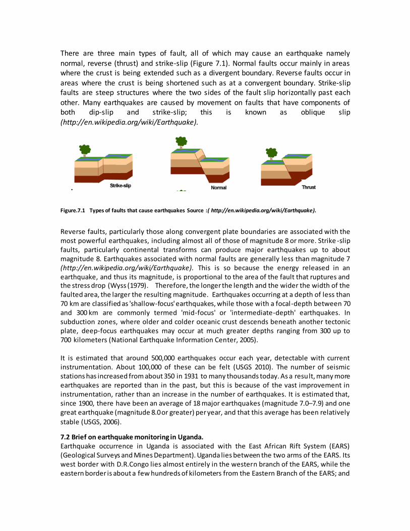
There are three main types of fault, all of which may cause an earthquake namely
normal, reverse (thrust) and strike-slip (Figure 7.1). Normal faults occur mainly in areas where the crust is being extended such as a divergent boundary. Reverse faults occur in
areas where the crust is being shortened such as at a convergent boundary. Strike-slip faults are steep structures where the two sides of the fault slip horizontally past each
other. Many earthquakes are caused by movement on faults that have components of both dip-slip and strike-slip; this is known as oblique slip (http://en.wikipedia.org/wiki/Earthquake).
.
Figure.7.1 Types of faults that cause earthquakes Source :( http://en.wikipedia.org/wiki/Earthquake).
Reverse faults, particularly those along convergent plate boundaries are associated with the most powerful earthquakes, including almost all of those of magnitude 8 or more. Strike -slip faults, particularly continental transforms can produce major earthquakes up to about magnitude 8. Earthquakes associated with normal faults are generally less than magnitude 7 (http://en.wikipedia.org/wiki/Earthquake). This is so because the energy released in an earthquake, and thus its magnitude, is proportional to the area of the fault that ruptures and the stress drop (Wyss (1979). Therefore, the longer the length and the wider the width of the faulted area, the larger the resulting magnitude. Earthquakes occurring at a depth of less than 70 km are classified as 'shallow-focus' earthquakes, while those with a focal-depth between 70 and 300 km are commonly termed 'mid-focus' or 'intermediate-depth' earthquakes. In subduction zones, where older and colder oceanic crust descends beneath another tectonic plate, deep-focus earthquakes may occur at much greater depths ranging from 300 up to 700 kilometers (National Earthquake Information Center, 2005).
It is estimated that around 500,000 earthquakes occur each year, detectable with current instrumentation. About 100,000 of these can be felt (USGS 2010). The number of seismic stations has increased from about 350 in 1931 to many thousands today. As a result, many more earthquakes are reported than in the past, but this is because of the vast improvement in instrumentation, rather than an increase in the number of earthquakes. It is estimated that, since 1900, there have been an average of 18 major earthquakes (magnitude 7.0–7.9) and one great earthquake (magnitude 8.0 or greater) per year, and that this average has been relatively
stable (USGS, 2006).
7.2 Brief on earthquake monitoring in Uganda. Earthquake occurrence in Uganda is associated with the East African Rift System (EARS) (Geological Surveys and Mines Department). Uganda lies between the two arms of the EARS. Its west border with D.R.Congo lies almost entirely in the western branch of the EARS, while the eastern border is about a few hundreds of kilometers from the Eastern Branch of the EARS; and
there is more seismic activity in the western than in the eastern branch. Other tectonic features
that have a great influence on earthquake occurrences in Uganda include:
(a) The Ruwenzori Mountains: The Ruwenzori massif and tectonic movements cause stress accumulation that is released along the border and boundary faults to the mountains. The faults
include: - Nyamwamba, Kicwamba, Bwamba, Kitimbi-Semuliki, Ruimi-wasa and Bunyoro –Toro.
(b) The Katonga Fault: This fault starts from foothills of the Ruwenzori Mountains, traverses Lake Victoria and connects to Kavirondo Gulf in western Kenya and Speke Gulf south of Lake
Victoria in Tanzania.
(c) Aswar Shear Zone: the shear zone is observed in Uganda from Nimule at Uganda –
Sudan Border and joins Mt Elgon on the eastern border with Kenya.
The tectonic setting mentioned above makes Uganda earthquake prone, and the tectonic movements of geological structures have been responsible for the occurrence of major
earthquakes in Uganda. The major earthquakes include the following:
On 9th July, 1912 the earthquake occurred in northern Uganda and had a magnitude of 6.7 on Richter scale. The epicentre was around Kitgum. There was partial destruction of buildings in northern Uganda;
On 2nd October, 1929 an earthquake occurred in Toro region western Uganda. It measured 5.9 on Richter scale and triggered landslides;
On 18th March, 1945 an earthquake occurred in Sembabule-Masaka region measuring 6.0 on Richter scale. This earthquake killed five people and destroyed buildings in Masaka Town;
On 20th March, 1966 an earthquake occurred in Toro region western Uganda. It measured 6.6 on Richter scale. This earthquake killed 150 and injured 1,300 people. It caused an economic loss estimated at US$ 1million (United Stated One Million Dollars);
On 7th September, 1990 an earthquake occurred around the Lake Victoria region. The epicentre was at Nakiwogo on the shores of Lake Victoria. It measured 5.0 on Richter scale. This earthquake destroyed semi-permanent buildings around Nakiwogo landing site;
On 9th October, 1991 an earthquake occurred in Lake Albert. The epicentre was around Butiaba. It measured 5.3 on Richter scale. The earthquake destroyed semi -permanent buildings within the environs of Butiaba;
On 5th February 1994 an earthquake occurred in Kisomoro (Kabarole District). It measured 6.2 on Richter scale. The earthquake killed 8 people and caused destruction of property estimated at US$ 61 million (United States Sixty One million Dollars).
7.3 History of earthquake monitoring in Uganda. Earthquake monitoring in Uganda started way back in 1918, with one analogue, long period, and single-component station. The station was operated by the then Geological Survey
Department at Entebbe
In the 1940’s, the operation of the seismic station was undertaken by the Department of Meteorology.
Operations of the station were later returned to the Geological Survey Mine Department in the 1960’s. The station operations completely came to stand still in the 1970’s due to economic
turmoil the country faced at that time.
Earthquake monitoring resumed in the early 1990’s after securing support from United Nations Education Scientific Cultural Organization (UNESCO). UNESCO provided funds that were used to purchase three analogue seismological stations that made the birth of the Uganda National Seismological Network.
7.4 Current status of the Uganda National Seismological Network The current network comprises of 4 digital broadband stations located in Entebbe - Wakiso District, Hoima- Hoima District, Kilembe Mines Ltd in Kasese District and at Kyahi near Mbarara
town – Mbarara District.
7.4.1 Entebbe Station
Entebbe station is being currently operated within the Department of Geological Survey and Mines Offices in Entebbe. Plans are underway to have the station transferred to a quitter place at Nakawuka, about 15 kilometers from Entebbe town, where a seismic vault has been
constructed.
7.4.2 Kilembe Station
Kilembe station is located within the premises of Kilembe Mines Ltd, it has been in operation since the early 1990’s. The station started with an analogue recording system, since then it has
gone through major upgrades from analogue to the digital recording mode.
7.4.3 Hoima station
Hoima station is located at Katasiha site, about 2 kilometers from Hoima town along the Hoima – Butiaba road. Like the Entebbe and Kilembe stations, Hoima station has been in operation since the early 1990’s. The station has been upgraded from analogue, single component short period station to a digital broadband recording mode. Recently a permanent Global Positioning System (GPS) was installed at this station. Both the seismic and GPS data will be used for crustal
deformation studies in the Albertine Graben.
7.4.4 Mbarara station
This station is located at Kyahi forest reserve about 13 kilometers from Mbarara town. The station was installed in 1999 with support from the Incorporated Research Institutions in Seismology through the University of California San Diego, USA. The station has also been upgraded to International Monitoring Standards. This station serves as an Auxiliary station to the international monitoring division of the Preparatory Commission for Comprehensive Nuclear
Test Ban Treaty organization (CTBTO).
7.5 Data uses and users In a global perspective, parties interested in use of earthquake data include the following: oil companies, structural engineers, insurance companies, mining companies, CTBTO, academic and research institutions, The data is utilized for proper land use planning for settlement and guiding the drilling for oil and gas in the country, monitoring of extraction, oil and gas, groundwater,
earthquake insurance purposes, structural designs, research and nuclear test verification.
On research front, earthquake data has been used to compute earthquake parameters which help to discriminate their source mechanisms, depth, fault length and rupture and also to determine seismic models, energy release, and magnitude so as to be able to produce seismic
hazard maps and building code used in planning for settlements and land use.
7.7 Regional and international collaborating Institutions.
The International Programs in Physical Sciences, (IPPS), Uppsala University Sweden. The IPPS has offered funding for several trainings in seismic data handling to Ugandans after the re -birth of the National Seismological Network. The IPPS has also provided spare parts to keep the
stations running.
7.7.1 East and Southern African Regional Seismological Working Group (ESARSWG).
This is a group of nine (9) member countries in East and Southern Africa with a uniting objective that centers on sharing and exchanging earthquake data and promoting research. The nine (9) countries in this group are, Ethiopia, Eritrea, Kenya, Malawi, Mozambique, Tanzania, Uganda,
Zambia and Zimbabwe.
7.7.2 Incorporated research institutions in Seismology (IRIS) through the University of
California San Diego, USA.
These institutions helped in the Establishment of Mbarara Global Seismographic station, at Kyahi forest reserve, near Mbarara town. In addition, they are providing spare parts for routine maintenance of the station.
7.7.3 The preparatory Commission for the Comprehensive Nuclear Test Ban Treaty
Organization. (CTBTO).
CTBTO has strengthened the Uganda National Data Center (NDC-N180) by providing high performance server, a V-SAT, and other Global communication infrastructure equipment (GCI). This has enabled the Uganda Seismic Network to access earthquake data received and archived
by the International Data center, a division within the CTBTO.
Over the years CTBTO sponsored members of the Uganda National Data Center to attend
several workshops, seminars and other training courses related to CTBTO verification regime.
7.8 Way forward and recommendations The current developments taking place in Uganda, i.e. the construction industry, dams, roads, proposed oil refinery and nuclear power plants, are prone to destruction by earthquakes. Therefore, a comprehensive seismic hazard assessment MUST be carried out at particular sites
of interest during development.
The current network of only four stations is not sufficient to accurately record and locate most of the earthquakes with lower magnitudes in earthquake prone zones and the entire country at large. It is therefore strongly recommended to increase the number of stations to at least 20 so
that all seismically active faults are clearly mapped and monitored.
The first group of Seismologists/Geophysicists who were trained in the 1990’s are either retired or deceased. The few available scientists in this field are poorly remunerated which has resulted in brain drain out of this country. It is also recommended that the working conditions and emoluments of scientists in this field be improved so that earthquake research in Uganda can be
tremendously improved.
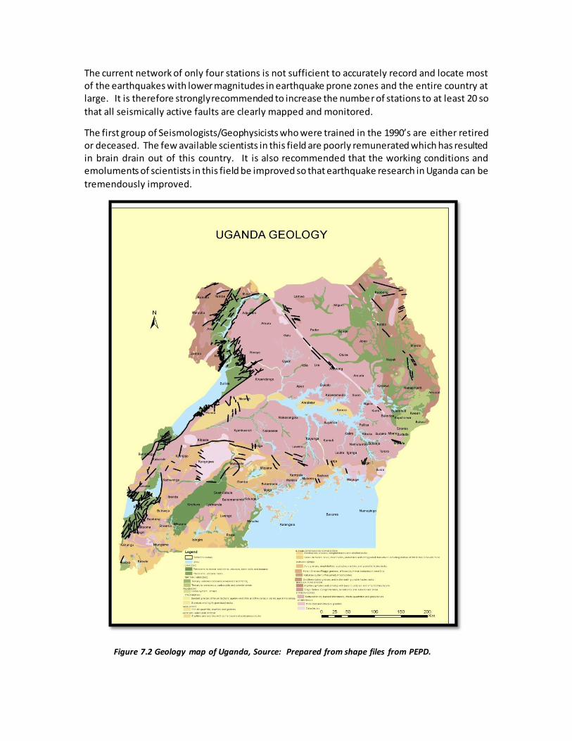
Figure 7.2 Geology map of Uganda, Source: Prepared from shape files from PEPD.
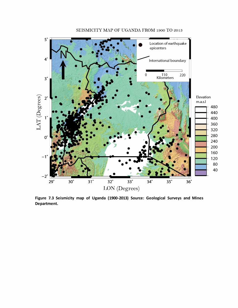
Figure 7.3 Seismicity map of Uganda (1900-2013) Source: Geological Surveys and Mines
Department.
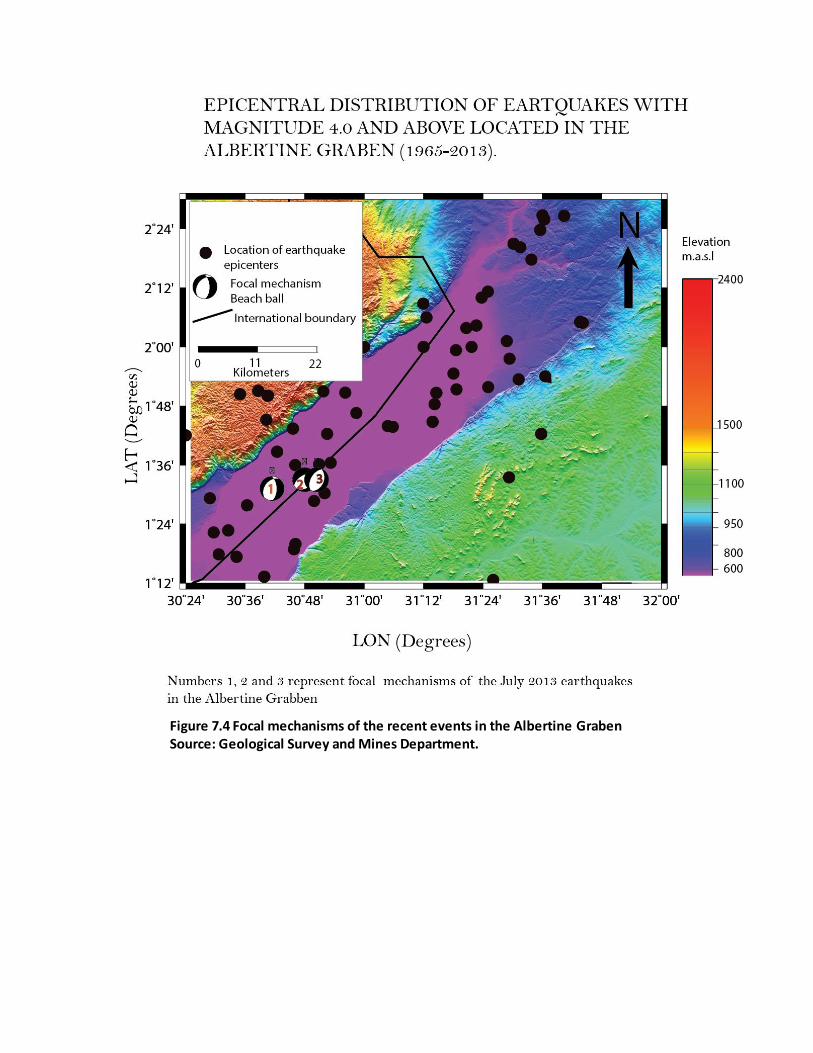
Figure 7.4 Focal mechanisms of the recent events in the Albertine Graben Source: Geological Survey and Mines Department.
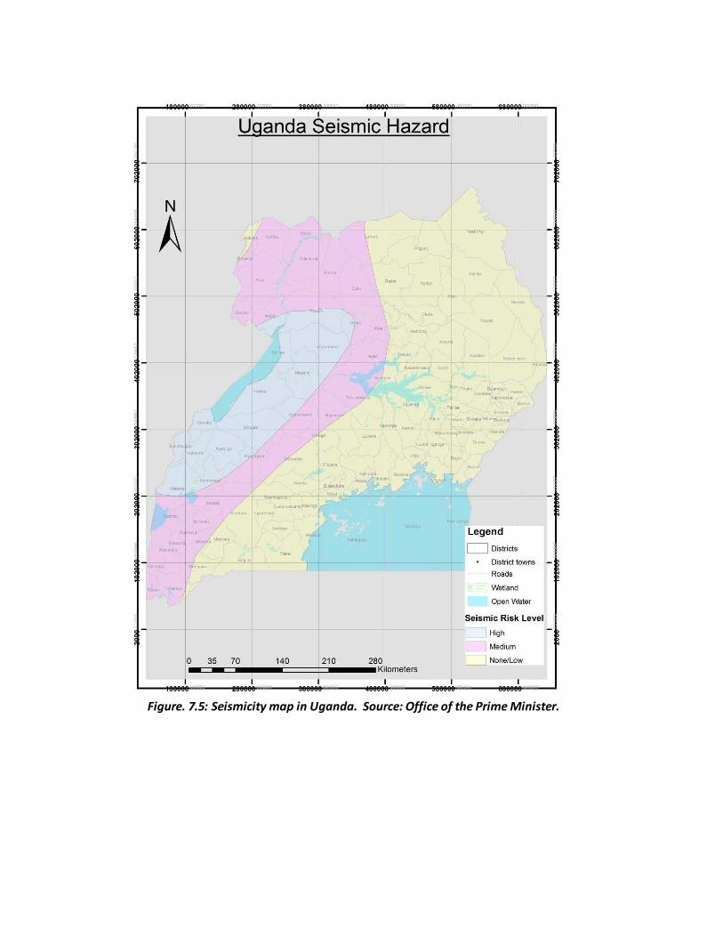
Figure. 7.5: Seismicity map in Uganda. Source: Office of the Prime Minister.


![On the influence of fault bends on the growth of sub ...authors.library.caltech.edu/50846/1/jgrb13702.pdf · 1. Introduction [2] Earthquakes generally result from a sudden rupture](https://img.pdfslide.us/doc/110x75/5f787eefc652ef0b7f10507f/on-the-influence-of-fault-bends-on-the-growth-of-sub-1-introduction-2-earthquakes.jpg)