Embed Size (px)
Citation preview
SRK Consulting
BSD Deepening EIR Page 76
JONS/REUT 367079_Transnet_Draft Berth Deepening EIA for public review February 2007
7 Assessment of Environmental Impacts 7.1 Introduction
During the Scoping process, potential environmental impacts associated with the proposed
deepening of the Ben Schoeman basin, and associated upgrade to Berth 601, 602, 603 and 604 have
been identified.
The specialist studies undertaken to address these issues listed in chapter 6 of this report included:
• Integrated Marine Assessment including:
• Shoreline Stability;
• Sediment movement associated with dredging and dredge disposal;
• Marine Ecology and Toxicology;
• Noise, Shock and Vibration Assessment;
• Traffic Impact Assessment;
• Visual Impact Assessment; and
• Marine Archaeology Assessment.
Proposed Terms of Reference for each of the specialist studies, based on the project description
provided in Chapter 3 were included in the Revised Plan of Study for EIA, as approved by DEAT.
Each of the specialist studies, presented in this chapter, assessed impacts associated with the upgrade
to berths, cranes and dredging activities at the Ben Schoeman Dock, and where appropriate, the
impacts of disposal of dredge spoil at each of the two potential dredge disposal sites identified. All
specialists were required to rate the significance of anticipated impacts and to recommend practical
mitigation measures, where appropriate.
The specialist studies have been collated in a separate Supplementary Volume of Specialist Reports,
which accompanies this Draft EIR.
7.2 Impact Rating Methodology
7.2.1 Impact Rating Procedure
Each specialist provided a description of the baseline conditions at the site as well as the description
and assessment of the potential impacts on the environment.
The assessment of impacts was based on the professional judgment of the specialists, fieldwork and
desk-top analysis. The significance of potential impacts that may result from the proposed project
were determined in order to assist decision-making by DEAT.
The significance of an impact is defined as a combination of the consequence of the impact
occurring and the probability that the impact will occur.
The criteria used to determine the consequence of an impact are presented in Table 7-1 below.

SRK Consulting
BSD Deepening EIR Page 77
JONS/REUT 367079_Transnet_Draft Berth Deepening EIA for public review February 2007
Table 7-1: Criteria used to determine the consequen ce of the impact
Rating Definition of Rating Score
A. Extent – the area in which the impact will be experienced
None 0
Local Confined to project or study area or part thereof (e.g. site) 1
Regional The region, which may be defined in various ways, e.g. cadastral, catchment, topographic
2
(Inter)national Nationally or beyond 3
B. Intensity – the magnitude or size of the impact
None 0
Low Wider (off site) natural and/or social functions and processes are negligibly altered 1
Medium Wider (off site) natural and/or social functions and processes continue albeit in a modified way
2
High Wider (off site) natural and/or social functions or processes are severely altered 3
C. Duration – the time frame for which the impact will be experienced
None 0
Short-term Up to 2 years 1
Medium-term 2 to 15 years 2
Long-term More than 15 years 3
The combined score of these three criteria corresponds to a Consequence Rating, as set out in Table
7-2:
Table 7-2: Method used to determine the consequence score
Combined Score (A+B+C) 0 – 2 3 – 4 5 6 7 8 – 9
Consequence Rating Not significant Very low Low Medium High Very high
Once the consequence was derived, the probability of the impact occurring was considered, using the
probability classifications presented in Table 7-3 below.
Table 7-3: Probability classification
Probability of impact – the likelihood of the impact occurring
Improbable < 40% chance of occurring
Possible 40% - 70% chance of occurring
Probable > 70% - 90% chance of occurring
Definite > 90% chance of occurring
The overall significance of impacts was determined by considering consequence and probability
using the rating system prescribed in Table 7-4.

SRK Consulting
BSD Deepening EIR Page 78
JONS/REUT 367079_Transnet_Draft Berth Deepening EIA for public review February 2007
Table 7-4: Impact significance ratings
Significance Rating Consequence Probability
Very Low & Improbable Insignificant
Very Low & Possible
Very Low & Probable
Very Low & Definite
Low & Improbable
Very Low
Low & Possible
Low & Probable
Low & Definite
Medium & Improbable
Low
Medium & Possible
Medium & Probable
Medium & Definite
High & Improbable
Medium
High & Possible
High & Probable
High & Definite
Very High & Improbable
High
Very High & Possible
Very High & Probable Very High
Very High & Definite
Finally the impacts were also considered in terms of their status (positive or negative impact) and the
confidence in the ascribed impact significance rating. The prescribed system for considering impacts
status and confidence (in assessment) is laid out in Table 7-5 below.
Table 7-5: Impact status and confidence classificat ion
Status of impact
+ ve (positive – a ‘benefit’)
– ve (negative – a ‘cost’)
Indication whether the impact is adverse (negative) or beneficial (positive).
Neutral
Confidence of assessment
Low
Medium
The degree of confidence in predictions based on available information, SRK’s judgment and/or specialist knowledge.
High
The impact significance rating should be considered by DEAT in their decision-making process
based on the implications of ratings ascribed below:
• Insignificant : the potential impact is negligible and will not have an influence on the decision
regarding the proposed activity/development.
• Very Low: the potential impact should not have any meaningful influence on the decision
regarding the proposed activity/development.
• Low: the potential impact may not have any meaningful influence on the decision regarding the
proposed activity/development.
• Medium: the potential impact should influence the decision regarding the proposed
activity/development.
• High: the potential impact will affect the decision regarding the proposed activity/development.
SRK Consulting
BSD Deepening EIR Page 79
JONS/REUT 367079_Transnet_Draft Berth Deepening EIA for public review February 2007
• Very High: The proposed activity should only be approved under special circumstances.
Specialists were required to recommend mitigation measures, and rate impacts both without and with
implementation of the mitigation measures recommended.
Mitigation measures are either:
• Essential: must be implemented and are non negotiable; or
• Optional: should be considered, and sound reasons provided by Transnet if not implemented.
As the implementation of “optional” mitigation measures cannot be assumed, the rating of impacts
with mitigation assumes only the implementation of essential mitigation measures.
7.2.2 Cumulative and Indirect Impacts
Where appropriate, specialists were required to assess cumulative and indirect impacts. In most
cases these assessments were qualitative and descriptive.
7.2.3 Integration of Studies into the EIA
The completed specialist studies and their findings have been integrated into the Draft EIR. The key
findings of each specialist were evaluated in relation to each other to provide an overall and
integrated assessment of the project impacts.
SRK has considered the suite of potential impacts in a holistic manner and in certain instances, based
on independent professional judgment and this integrated approach, has altered impact significance
ratings. Where this has been done it has been indicated in the relevant section of the report.
7.3 Potential Marine Impacts
7.3.1 Marine Impact Study Introduction and Terms of Reference
This section of the report has been based on the Integrated Marine Study undertaken by CSIR and
attached as Appendix C1. This Integrated Marine Study is based on three detailed specialist studies
including:
• Specialist study on Sediment Toxicology and Marine Ecology, undertaken by Lwandle
Technologies (Pty) Ltd (Appendix C2);
• Specialist study on Shoreline Dynamics in Table Bay, undertaken by the CSIR (Appendix C3);
and
• Specialist study on Dredging and Disposal of Dredge Spoil, undertaken by the CSIR (Appendix
C4).
Each of these individual specialist studies have undergone external specialist review, and relevant
comments by reviewers, as well as responses to the comments, as provided by CSIR included in
Appendix C5. Where appropriate, responses to comments by reviewers have been addressed in the
final specialist reports used for the purposes of this EIA.

SRK Consulting
BSD Deepening EIR Page 80
JONS/REUT 367079_Transnet_Draft Berth Deepening EIA for public review February 2007
Integrated Marine Study:
The approach to the Integrated Marine Study was as follows:
• A preliminary characterisation was undertaken of the physical and biogeochemical properties of
the material to be dredged from the Ben Schoeman Dock. Based on this characterisation,
available literature and other information such as bathymetric charts, a screening of potential
dredge disposal sites was undertaken and two sites identified (as required by the project brief).
Field surveys were then planned to characterise the physical, biogeochemical and ecological
characteristics and significance of these proposed dredge disposal sites;
• The field survey was undertaken over a period of three days (31 August 2006 to 2 September
2006) and included a bathymetric survey, a side-scan sonar survey and sampling of the
sediments at the seabed. The sampling was undertaken based on the geophysical characteristics
of the seabed and habitats inferred from the side-scan sonar survey;
• Sediment samples from the disposal sites were characterised in terms of their physical properties
(grain size analysis), biogeochemical properties (trace metals) and benthos. Simultaneously, the
existing geotechnical cores from the Ben Schoeman Dock were sub-sampled and analysed to
ascertain the trace metal loads in the deeper sediments to be dredged from the Ben Schoeman
Dock. (The characteristics of the surface sediments were already known from previous CSIR
survey within the Port of Cape Town.);
• An assessment of potential impacts in the marine environment was undertaken based on:
− the quantities and characterisation of the sediments to be dredged;
− the characterisation of the proposed dredge disposal sites,
− consideration of potential environmental effects of dredging and dredge disposal activities,
and
− the sensitive ecosystems and existing beneficial uses of regions likely to suffer impacts,
A simulation modelling approach was used to predict the behaviour and distributions of suspended
sediments, associated contaminants and discharged sediments associated with the proposed dredging
of the Ben Schoeman Dock basin. Modelling considered:
• each of the three dredging options;
• disposal at each of the two potential dredge disposal sites; and
• disposal of dredge spoil under summer and under winter conditions.
The approach used in the assessment of marine impacts has been to select the apparent worst case
scenarios and to evaluate the associated impacts. The approach is thus essentially conservative.
Included is this conservative approach is the modelling and assessment of marine impacts with the
assumption that volumes of spoil dredged from the harbour are 10%25 larger than stated in the
project description (Table 3-2). This is a safety margin to ensure a robust EIA description should
25 This is a factor of safety as the exact volume of material to be removed cannot be accurately estimated, and
does not relate to the “bulking” of sediments once brought to the water surface.

SRK Consulting
BSD Deepening EIR Page 81
JONS/REUT 367079_Transnet_Draft Berth Deepening EIA for public review February 2007
there be over dredging. The specific terms of reference for each of the individual marine-related
specialist studies were as follows:
Sediment Toxicology and Marine Ecology:
• Assess the dredge sediment properties in terms of particle size distributions, contaminant
concentrations, and toxic condition. The data for this will be drawn from the CSIR sediment
property surveys and previous investigations commissioned by the NPA. These will be
supplemented by analyses to confirm the vertical distribution of chemical properties such as
metals in the sediments to be dredged. These supplemental analyses will require access to and
sub-samples (mid-depth and full depth of proposed dredging) of the drilled cores in the Ben
Schoeman Dock. The analyses will comprise assessment of total metals in the samples as well as
grain size analyses;
• Identify areas that may be at risk from the proposed activities. For dredge spoil disposal this will
require access to the results of the dredge spoil simulation modelling to be conducted as part of
the EIA by CSIR;
• Identify the biological communities that may be at risk from the proposed operations. This will
be based on information sourced during the container terminal expansion EIA and the recent
SEA conducted for the port as well as the proposed fieldwork;
• Qualify the risks that the proposed operations may pose in terms of accepted water and sediment
quality guidelines. This will be based on the recently (2006) compiled water quality guidelines
for the BCLME programme. These Guidelines are based on up-to-date international best
practice, Australian and New Zealand practice, DWAF water quality guidelines for RSA coastal
waters and work published in the scientific literature;
• If water/sediment quality guidelines are exceeded, quantify the risks in terms of the proportions
of biological populations under threat and qualify these in terms of ecological consequences;
• Where required, identify the need for mitigation and suggest methods to achieve this;
• Devise a practical monitoring programme that will, firstly, allow real time control of project
activities to reduce environmental risks and, secondly, facilitate a qualitative determination of
actual versus predicted project impacts;
• Conform to any relevant guidelines for specialist studies issued by the DEA&DP.
Shoreline Dynamics:
• Confirm whether disposal of dredge spoil at depths of 40 - 70 m or 70 - 100 m have any
significant impact on shoreline stability (erosion/accretion) in Table Bay using a review of
recent literature;
• If the study indicates a likely impact on shoreline stability, undertake the contingency study as
outlined in the contract documentation26; and
26 The outcome of the initial literature survey and screening study indicated that the contingency study as
proposed was not necessary, provided that specific requirements in terms of the nature of the dredge disposal
could be fulfilled by the dredging contractor.
SRK Consulting
BSD Deepening EIR Page 82
JONS/REUT 367079_Transnet_Draft Berth Deepening EIA for public review February 2007
• Conform to any relevant guidelines for specialist studies issued by the DEA&DP.
Dredging and Disposal of Dredge Spoil:
• Identify likely dredging methods and options of transporting dredged material from the BSD to
the marine disposal site;
• Estimate the likely duration of dredging operations as well as seasonal and daily dredging
schedules;
• Locate and characterise two sites at between 40m to 70m and 70m to 100m of depth,
respectively, that would be suitable for the disposal of dredge spoil using preliminary side-scan
and bathymetric survey techniques as well as sampling of sediment;27
• Produce a model of the disposal of dredge material at the following disposal sites:
• Deep water (between 40m and 70m) dredge disposal; and
• Deep water (between 70m and 100m) dredge disposal;
• If required, assess concerns regarding the disposal of the non LC-compliant portion of the spoil
material to a suitable land-based waste facility and the associated transport and processing
requirements (e.g. dewatering of the spoil etc); and
• Conform to any relevant guidelines for specialist studies issued by the DEA&DP.
In the case of the marine study, much of the work undertaken was aimed at identifying suitable
dredge methodologies, dredge disposal sites, and obtaining baseline information, based on which an
assessment of the marine (and other) impacts could be undertaken.
7.3.2 Marine Baseline Information
A detailed description of the marine environment has been provided in the integrated marine report
(and associated specialist reports) as well as in Chapter 5 of this EIR. Baseline information relevant
to the impacts on the marine environment has been summarised in this section for ease of reference.
Important components of the marine ecosystem in Table Bay are the habitats within the bay, the
benthos, the Table Bay pelagic communities, the Table Bay harbour communities, seabirds and
marine mammals.
Important resources and recreational fisheries in Table Bay include:
• Three important commercial abalone zones;
• White mussel (D. Serra) that are harvested recreationally for bait and human consumption;
• Commercial line fisheries for Hottentot, Snoek and other species including Long Fin Tuna, Chub
Mackerel and Chokka.
27 Note that although the original requirement was to identify one of the sites at 70 to 100m depth, the suitable
site identified during the side scan sonar ranges from 65 to 75m depth. This is not considered problematic in
any way, and the identification of this site has been discussed in detail with MCM.
SRK Consulting
BSD Deepening EIR Page 83
JONS/REUT 367079_Transnet_Draft Berth Deepening EIA for public review February 2007
In terms of biogeography and unique biodiversity resources, the rocky shore and sandy beach
communities (with the exception of dense white mussel beds at Bloubergstrand), the benthic
communities and the pelagic fish and marine mammals occurring in Table Bay are typical of the
West Coast and not unique to Table Bay. Table Bay therefore cannot be classified as a locally,
regionally or internationally important biodiversity resource. The only strong exception to the above
statement are the seabirds of the area (especially the African Penguin and the Bank Cormorant
whose population size, endemism and conservation classification make these seabirds significant
biodiversity resources).
Existing beneficial uses in Table Bay include:
• Marine Protected and Conservation Areas (i.e. the Table Bay Rock Lobster Sanctuary, the Table
Mountain National Park Marine Protected Area and Robben Island which is a provincial nature
reserve with no formal Marine Protected Area, however the sea area within a 1 nautical mile
radius of Robben Island can be considered to be environmentally sensitive because of its
conservation importance to African Penguins and Bank Cormorants;
• Marine outfalls (Green Point pipeline and Chevron/Caltex pipeline);
• Used and disused sea cables with landfalls at Milnerton and Melkbosstrand and from Granger
Bay and Murrays Harbour and the Port of Cape Town;
• Vessel navigation and anchorages;
• Recreational activities (surfing, sailing, kite-surfing, swimming, fishing, etc).
• Tourism (e.g. Victoria and Alfred waterfront)
• The Two Oceans Aquarium that is located in the Victoria and Alfred Basin.
Biological species diversity and numbers in the harbour are generally low, due to the disturbed
nature of the harbour environment. Benthos inhabiting the sediments appear to be limited, if not
completely absent due to the existing high pollutant levels in the basin, associated with current
activities and stormwater inlets.
Dredge disposal Site 1 has a higher benthic biomass and biomass richness than Site 2. Although Site
2 has a lower biomass, it has a higher diversity in benthic macrofauna, due to the higher diversity of
habitats represented on this site.
Dredge disposal Site 1 is situated approximately 13km offshore of the nearest beach in Table Bay.
The nearest beach to the south is Clifton, situated approximately 6km to the south-east of this site.
Dredge disposal Site 2 is situated approximately 9km away from the nearest sandy beach in Table
Bay. Clifton beach is once again the closest sandy beach to the south, situated about 5km from this
site.
The beaches that could be affected by a mound of sediment disposed offshore are those which lie in
the path of the waves that may conceivably be disturbed by the mound. Figure 7-1 below indicates
the typical distribution of wave heights and directions offshore of Table Bay. This indicates that
waves from disposal Site 2 move towards to the shoreline in Table Bay ~9km away. Although
Camps Bay and Clifton beaches are about 5km away, they are positioned such that they are not on
the path of the waves moving from the disposal sites under most conditions. The exception would be

SRK Consulting
BSD Deepening EIR Page 84
JONS/REUT 367079_Transnet_Draft Berth Deepening EIA for public review February 2007
rare northerly wind-generated waves, although these waves generally have short periods and
therefore would be unaffected by small bathymetry changes at depths of about 40m and more.
Figure 7-1: Typical distribution of wave heights an d directions in Table Bay
SRK Consulting
BSD Deepening EIR Page 85
JONS/REUT 367079_Transnet_Draft Berth Deepening EIA for public review February 2007
7.3.3 Marine Impact Assessment
Impacts assessed in this section of the report have been broadly divided as follows:
• Impacts on the harbour environment, largely related with dredging activities;
• Impacts on dredge spoil disposal sites, and surrounding areas, largely related to the disposal of
dredge spoil; and
• Impacts on existing activities in Table Bay.
Potential Impacts on the Harbour
The following potential impacts associated with the dredging operation in the harbour were rated as
being insignificant and thus not requiring mitigation. They have thus not been discussed in further
detail in this report28:
• Remobilisation of contaminants in dredged sediments disrupting ecological processes and/or
compromising biological organisms;
• Reductions in dissolved oxygen concentrations due to introduction of organic matter previously
held in the sediments to the water column affecting biogeochemical processes;
• Release of nutrients previously held in pore waters in the sediments to the water column
promoting eutrophication;
• Altered seawater quality through, e.g., remobilised contaminants in the dredged sediment
affecting other beneficial uses of the harbour environment;
• The effects of noise from the dredging activities on biological organisms in the harbour;
• The effects of dredging activities on endangered seabirds; and
• Mortality to harbour biota from shock waves generated by small parcel blasting to remove rock.
Potential impacts on the harbour environment associated with the dredging operation which have
been assessed further in this report include:
• Removal/destruction of biological communities in the dredge target areas;
• Effects of turbid plumes generated by dredging on organisms inhabiting harbour sediments and
structures;
• Settlement of material suspended during dredging and alteration of sediment characteristics and
associated biological communities;
• Importation of alien species by dredgers and associated ecological effects; and
• Effects of turbidity on endangered coastal seabirds (specifically the African Penguin.
28 Details of the nature and assessment of these impacts are provided in the integrated marine report, and
supporting specialist studies.
SRK Consulting
BSD Deepening EIR Page 86
JONS/REUT 367079_Transnet_Draft Berth Deepening EIA for public review February 2007
Potential Impacts on Dredge Disposal Sites
The following potential ecological impacts associated with the disposal of the dredge spoil to the
designated dredge disposal site were rated as being insignificant and have not been assessed further
in this report:
• Potential erosion of the shoreline as a result of dumping of the dredge material.
• Toxic effects of trace metal contaminated dredge spoil on benthos at the dredge spoil dump site
and its immediately adjacent area and disruption to ecological processes;
• Effects of turbidity from dredge spoil on habitats adjacent in dump area(s);
• Reductions in water column oxygen concentration in spoil dump area(s) and effects on
biological communities; and
• Inundation of intertidal shores in the adjacent marine protected areas.
Potential impacts on the dredge disposal sites, and surrounding areas, as a result of the disposal of dredge soil, which have been assessed further in this report include:
• Deposition of discharge sediment and effects on benthic macrofauna;
• Alteration of benthic biological communities through toxins associated with dredge spoil;
• Effects of turbidity generated by dredge spoil disposal on habitats adjacent to the dredge spoil
disposal sites;
• Effects on water quality in the Table Mountain National Park MPA (and other MPA’s) and
resulting effects on biota as a result of sediment plumes; and
• Introduction of alien species to dredge disposal sites.
Potential Impacts on existing activities in Table Bay
Two possible impacts of dredging activities and the disposal of dredge material on other existing
activities in Table Bay, as assessed in this report include:
• Deposition of sediments in existing dredge areas and/or navigation channels; and
• Interference with existing shipping.
Although a potential impact on the Two Oceans Aquarium has been identified due to the seawater
intake being positioned in the Victoria and Alfred basin, the Two Oceans Aquarium has established
emergency procedures to cope with unsuitable quality intake water. These include running the
aquarium system in recirculation mode and/or obtaining seawater from an alternative location such
as Granger Bay and using road tankers to transport the water to the aquarium. Therefore, although
unlikely to be required, the Two Oceans Aquarium does have procedures in place that would protect
it from compromised water quality in the region of its seawater intakes. This potential impact is thus
considered to be of low significance and has not been assessed further in this report.
Potential marine impacts are described and assessed in more detail in the following sub-sections
(both without and with the implementation of the mitigation measures listed in Section 7.3.5)
SRK Consulting
BSD Deepening EIR Page 87
JONS/REUT 367079_Transnet_Draft Berth Deepening EIA for public review February 2007
7.3.3.1 Impacts on harbour environment
Although various dredge scenarios are being considered, the impacts of dredging on the harbour
environment are expected to be similar in each case, and where they may differ, the worst case
scenario has been assessed for each potential impact.
Impact 1: Removal of biological communities in the dredge target areas
During the proposed dredging, approximately 1.23 million m3 of material (which includes hard and
soft rock) will be dredged from the port. This material will have marine biota associated with them
which will be removed along with the dredge spoil. There is a marked gradient within the port in
biofouling organisms on harbour structures, biomass declining rapidly with distance from the
harbour entrance. There are no reported surveys on spatial distributions of benthos in the sediments
but spot sampling in Duncan Dock, Victoria Basin and Alfred Dock showed a complete absence of
fauna (CMS 1995a). This was attributed to anoxic sediments and hydrocarbon pollution. Such a
severe situation is not expected for Ben Schoeman Dock Basin sediments, but it is likely that the soft
sediment benthos is impoverished.
As a result of dredging operations sediments and their associated organisms will be physically
removed from the seabed along the path of the dredger during dredging. An area of approximately
1.1 km2 within the harbour will be affected. The majority of the benthic organisms are likely to die
or be removed from the dredge area, although the overall numbers of organisms affected is expected
to be low.
Due to the local extent of the impact (limited to the harbour area), and the fact that it will occur in
what can essentially be considered an artificial habitat, the significance of this impact is considered
to be very low, and no mitigation measures are considered necessary or feasible. An assessment of
this impact “with mitigation” has thus not been provided below.
Table 7-6: Significance of the potential removal of biological communities in the dredge target areas
Extent Intensity Duration Consequence Probability Significance Status Confidence
Without mitigation
Local 1
Medium 2
Short-term 1
Very low 4
Definite VERY LOW -ve High
With mitigation
n/a n/a n/a n/a n/a n/a n/a n/a
The significance of the potential removal of biological communities in the dredge areas is therefore
rated as very low.
Impact 2: Effects of turbid (sediment) plumes generated by dredging on organisms inhabiting
harbour sediments and structures
Dredging activities characteristically generate turbid plumes of suspended sediment. High suspended
solid concentrations can exert negative effects on organisms through light attenuation
(phytoplankton and algae), interference with filter feeding (zooplankton, mussels, oysters,
barnacles), damage to gills and respiratory processes (mussels, oysters, abalone, fish), reduction of
visibility reducing foraging success (cormorants, penguins, predatory fish) but also assisting predator
avoidance in fish (Clark 1997a), etc.

SRK Consulting
BSD Deepening EIR Page 88
JONS/REUT 367079_Transnet_Draft Berth Deepening EIA for public review February 2007
The South African Water Quality Guidelines for the Natural Environment (DWAF, 2005) provide an
upper limit for dissolved trace metals as well as a guideline for suspended sediments in the water
column. The relevant guidelines are summarised in Table 7-7 below.
Table 7-7: South African Water Quality Guidelines f or the water column
Constituent Upper Limit
The following target values apply to marine waters outside of a specific sacrificial zone:
Colour/turbidity/clarity
Should not be more than 35 Hazen units above ambient concentrations (colour) Should not reduce the depth of the euphotic zone by more than 10 % of ambient levels measured at a suitable control site (turbidity)
Suspended solids Should not be increased by more than 10 % of ambient concentrations. This is largely based on aesthetic impacts.
Dissolved oxygen Dissolved oxygen should not fall below 5 mg/l (99 % of the time) and below 6 mg/l (95 % of the time)
Ammonium, Nitrate, Nitrite, Phosphate, Silicate
Waters should not contain concentrations of dissolved nutrients that are capable of causing excessive or nuisance growth of algae or other aquatic plants or reducing dissolved oxygen concentrations below the target range indicated for Dissolved oxygen (see above)
Ammonia 20 µg N per litre (as NH3) or 600 µg N per litre (as NH3 plus NH4+)
Arsenic (As) 12 µg/l
Cadmium (Cd) 4 µg/l
Chromium (Cr) 8 µg/l
Copper (Cu) 5 µg/l
Lead (Pb) 12 µg/l
Mercury (Hg) 0.3 µg/l
Nickel (Ni) 25 µg/l
Zinc (Zn) 25 µg/l
Source: CSIR (2006b)
Due to the fact that the harbour is an environment which is already disturbed, and would not have
water quality found under natural conditions the following water quality guidelines and suspended
sediment limits that were developed for already disturbed ecosystems, are considered applicable:
• Australian and New Zealand Environment Conservation Council (ANZECC) water quality
guidelines (2000) for a moderately to highly disturbed or polluted system (aiming to protect 80%
of species with a 95% certainty). These guidelines specify higher limits for trace metals, as
shown in Table 7-8 below.

SRK Consulting
BSD Deepening EIR Page 89
JONS/REUT 367079_Transnet_Draft Berth Deepening EIA for public review February 2007
Table 7-8: ANZECC water quality guidelines
Constituent Upper Limit
Cadmium (Cd) 36 µg/l
Chromium (Cr) 85 µg/l
Copper (Cu) 8 µg/l
Lead (Pb) 12 µg/l
Nickel (Ni) 560 µg/l
Zinc (Zn) 43 µg/l
Source: CSIR (2006b)
• Guidelines for suspended sediment concentrations in the water column from dredging activities
at the West Coast of southern Africa developed by Embecon (2004). Embecon suggest that total
suspended sediment concentrations below 100 mg/l represent limited risks for biota; and
• Guidelines for sediment with comparable levels of contamination to those in the BSD quoted by
Geffard et al. (2002) (quoted in Lwandle 2006a), which indicate that significant toxicity effects
may only be generated at 2000 mg/l suspended sediment.
The suspended sediment concentrations thresholds applicable to the harbour are those of
EMBECOM (2004) These identify exposures to 20mg/l for continuous periods of three days or
longer as the lower threshold of possible adverse ecological effects. Probable adverse effects may be
generated in exposures to 80mg/l but 100mg/l concentrations have proven negative impacts. This
assessment utilises 20mg/l suspended sediment as a low risk threshold and 100mg/l as the upper
permissible limit.
The limited assessments of total suspended sediment concentrations that have been made in Cape
Town harbour indicate that ambient levels are relatively high (average 30mg/l). It is inferred that
both the biofouling community on the harbour walls and benthos in the sediment have
accommodated this.
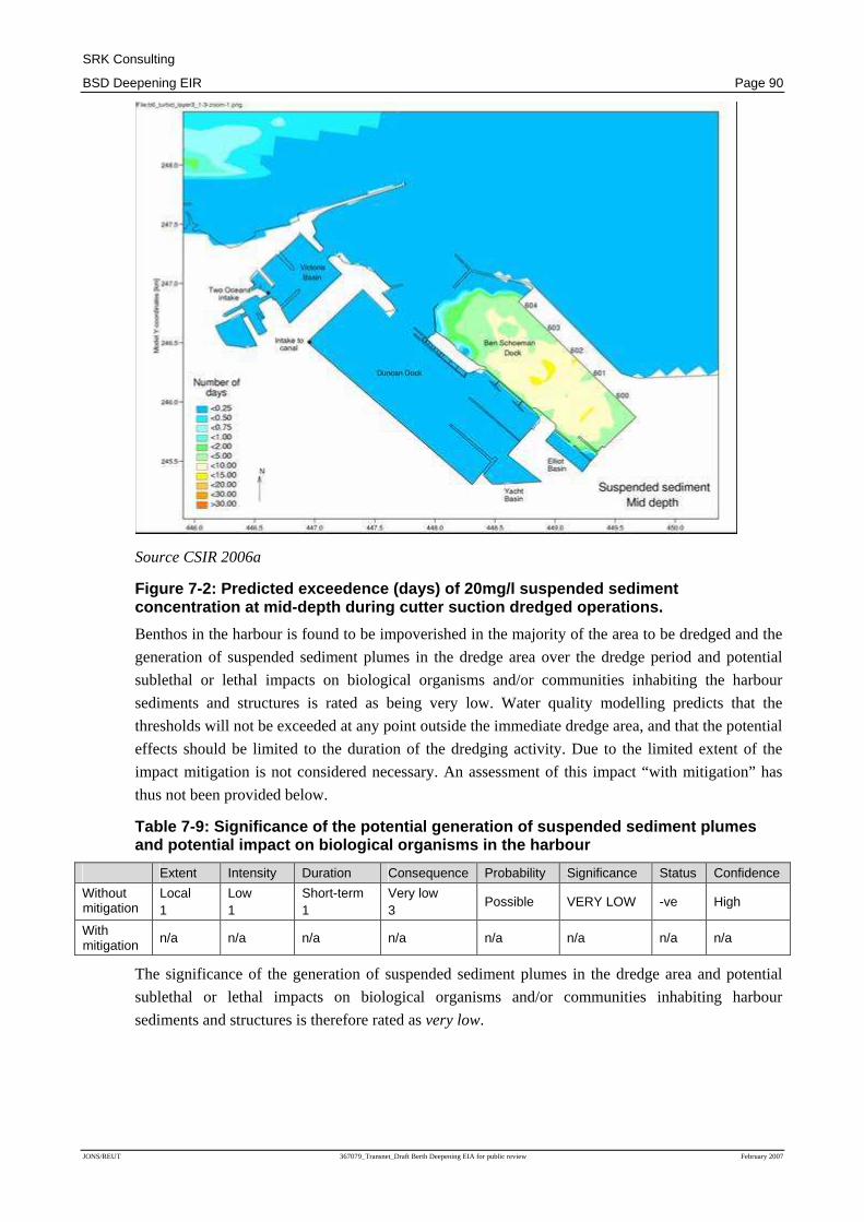
The worst case scenario in terms of exceedance of the 20mg/l suspended sediment threshold
demonstrated by the simulation modelling of turbidity plumes generated by the proposed dredging
(CSIR 2006c) is illustrated in Figure 7.229. This is expected to be caused by the cutter suction
dredger at mid-depth. The figure shows that the turbidity plumes should be contained within the Ben
Schoeman Dock and that the 20mg/l threshold may be exceeded for 5-10 days of the period
modelled (90 days). The biota within the Ben Schoeman Dock may be exposed to suspended
concentrations of ~50mg/l for 5-10 days during the dredging period. This is half the critical level
identified by EMBECOM (2004).
29 Note that in this and all subsequent turbidity modelling figures referred to in this report, the number of days
for which relevant sediment levels are exceeded related to the cumulative total of time during which these
levels are exceeded within a 90 day period.
SRK Consulting
BSD Deepening EIR Page 90
JONS/REUT 367079_Transnet_Draft Berth Deepening EIA for public review February 2007
Source CSIR 2006a
Figure 7-2: Predicted exceedence (days) of 20mg/l s uspended sediment concentration at mid-depth during cutter suction dr edged operations.
Benthos in the harbour is found to be impoverished in the majority of the area to be dredged and the
generation of suspended sediment plumes in the dredge area over the dredge period and potential
sublethal or lethal impacts on biological organisms and/or communities inhabiting the harbour
sediments and structures is rated as being very low. Water quality modelling predicts that the
thresholds will not be exceeded at any point outside the immediate dredge area, and that the potential
effects should be limited to the duration of the dredging activity. Due to the limited extent of the
impact mitigation is not considered necessary. An assessment of this impact “with mitigation” has
thus not been provided below.
Table 7-9: Significance of the potential generation of suspended sediment plumes and potential impact on biological organisms in the harbour
Extent Intensity Duration Consequence Probability Significance Status Confidence
Without mitigation
Local 1
Low 1
Short-term 1
Very low 3
Possible VERY LOW -ve High
With mitigation
n/a n/a n/a n/a n/a n/a n/a n/a
The significance of the generation of suspended sediment plumes in the dredge area and potential
sublethal or lethal impacts on biological organisms and/or communities inhabiting harbour
sediments and structures is therefore rated as very low.

SRK Consulting
BSD Deepening EIR Page 91
JONS/REUT 367079_Transnet_Draft Berth Deepening EIA for public review February 2007
Impact 3: Settlement of material suspended during dredging and alteration of sediment
characteristics and effects on sediment biota and ecological processes
The harbour is by design a quiet water area and it is likely that the majority of the fines in dredge
hopper overwash and those suspended by dredge head turbulence will resettle in the harbour. This
may lead to inundation of sediment biota adjacent to the dredge areas, possibly altering community
structure and/or disrupting ecological processes (e.g. by smothering benthos in the harbour
sediments).
As stated previously the harbour sediment community is relatively impoverished and may be kept
that way by pollution and physical disturbance (e.g. sediment suspension) by shipping and
stormwater outfalls into the harbour. Benthic macrofauna have been shown to survive short term
inundation and examples of bivalve molluscs and gastropods have been found to migrate vertically
up to 16cm when inundated with sand; with some amphipods, crabs and polycheates migrating
vertically up to 30cm. Therefore given the generally slow sedimentation rates of fine particles, the
probable non-unique biological community that is present and the ability of benthic macrofauna to
survive relatively rapid sedimentation events, the maximum inundation depths predicted by
simulation modelling of 5-10cm, significant disruption of the benthos in the harbour area is not
expected.
Due to the low significance of this impact, mitigation measures are not considered necessary. An
assessment of this impact “with mitigation” has thus not been provided below.
Table 7-10: Significance of potential settlement of suspended sediments and the effects on sediment biota and ecological processes.
Extent Intensity Duration Consequence Probability Significance Status Confidence
Without mitigation
Local 1
Low 1
Short-term 1
Very low 3
Definite VERY LOW -ve High
With mitigation n/a n/a n/a n/a n/a n/a n/a n/a
The significance of the potential settlement of suspended sediment and the effects on sediment biota
and ecological processes is therefore rated as very low.
Impact 4: Importation of alien species by dredgers and associated ecological effects
Dredgers may transport alien biota in ballast water, in residual sediment in their hoppers or even
attached as biofouling organisms on their hulls. The release of alien species into the Port of Cape
Town by dredgers carries the risks of allowing the establishment of populations and potential
competitive exclusion (food, space, nutrients) of indigenous species. In the worst case such imports
may lead to the development of invasive populations with the capacity to severely disrupt and
modify communities and ecological processes.
Despite a long history of international shipping passing through South African ports there are only
16 confirmed cases of alien species becoming established in the country's coastal waters and/or
ports. The best known of these is the Mediterranean mussel Mytilus galloprovincialis, currently the
mainstay of the local mussel farming industry, the ascidian Ciona intestinalis, a biofouling organism
common in harbours, and the European shore-crab Carcinus maenas. Other alien species that have
or may exert deleterious effects on ecological processes or industries dependent on these include the
harmful algal bloom dinoflaggelate species Alexandrium tamarense and Gymnodinium cf. mikimotoi

SRK Consulting
BSD Deepening EIR Page 92
JONS/REUT 367079_Transnet_Draft Berth Deepening EIA for public review February 2007
and the brown microalgae Aureococcus anophagefferens. In addition to these, 22 species are
classified as 'cryptogenic', i.e. organisms with wide distributions suspected of being alien.
The mussel and ascidian can be regarded as invasive in that they have replaced or displaced
indigenous fauna and have economic implications. The other species have small, restricted
populations. This notwithstanding, the Port of Cape Town is known to support established
communities of ~ 5 alien species, and is also known to be inhabited by a range of cryptogenic
species that have become established but do not possess large populations.
The impact of the import and release of alien species by dredgers and their establishment in habitats
within the harbour area is considered to be of a local-to-regional extent, with a possible extension to
national significance. Impacts would be long term to permanent as, once established, it is unlikely
that alien species would be obliterated by natural processes of competition, predation etc. The
probability and thus the significance of this impact occurring can be mitigated through the
application of the applicable ballast water management protocols stipulated in the International
Maritime Organisation (IMO) International Convention for the Control and Management of Ship’s
Ballast Water and Sediments, which have been shown to reduce viable organisms by 95%. Although
the probability of the impacts occurring would be reduced, it must be noted that ballast water
treatment measures would not address the risk resulting from residual sediments in these vessels.
Rigorous flushing and washing of both dredger and barge hoppers may constrain the risks here but it
is not clear how this can be achieved.
Table 7-11: Significance of the potential importati on of alien species by dredgers and associated ecological effects in the harbour
Extent Intensity Duration Consequence Probability Significance Status Confidence
Without mitigation
Regional 2
Medium 2
Long-term 3
High 7
Probable HIGH -ve Medium
With mitigation
Regional 2
Medium 2
Long-term 3
High 7
Improbable LOW -ve Medium
The significance of the potential importation of alien species by dredgers and the associated
ecological effects, assuming the implementation of mitigation measures, therefore rated as low.
Note: Although the prescribed impact rating methodology results in a medium significance rating
with mitigation, based on the experience and opinion of the specialists and EIA consultant, this
impact is considered to be of low significance, primarily due to the existing risk posed by the large
number of vessels entering the port from international waters.
7.3.3.2 Impacts on Dredge Spoil Disposal Sites
In most cases, the impacts of the disposal of dredge spoil material on the dredge spoil site will differ
for Site 1 and Site 2, and separate impact ratings have been provided for each site, to facilitate a
comparative assessment of the suitability of each of the dredge disposal sites, in Chapter 8.
Impact 5: Deposition of discharged sediment and effects on benthic macrofauna
The discharge of ~1.23 million m3 of dredge spoil to the dredge spoil disposal site will inundate the
resident benthos, possibly disrupting community structure and ecological processes at the site. The
identified dump sites are approximately 3 km x 2 km in size which should result in an average
inundation depth of 0.3m (30cm). Most of the major faunal classes in the benthos have been shown
to be able to withstand such burial depths and once the dumped sediment has stabilised, it is likely

SRK Consulting
BSD Deepening EIR Page 93
JONS/REUT 367079_Transnet_Draft Berth Deepening EIA for public review February 2007
that fauna will both migrate into the spoil dump area and recruit to it with a relatively short recovery
period.
However, due to the spoil dumping practices followed by dredgers and/or barges carrying dredge
spoil it is considered to be highly unlikely that an even distribution of dumped dredge spoil will be
achieved. It is possible that there could be unevenness leading to mound heights that exceed 0.3 m.
It is anticipated that localised mounds with peaks of up to 0.6 to 0.7 m could occur due to the nature
of the proposed dredge spoil dumping and the difficulty in obtaining an even distribution of
sediments over the dump-site. This could cause higher mortality levels in the benthos, in localized
areas. Recovery periods should however be equally short.
The two potential dredge spoil disposal sites differ in sediment properties and in benthos community
structure. Consequently the potential impact of sediment deposition on the benthos is evaluated
separately for each site.
Site 1
Site 1 is characterised by a more or less uniform fine sand sediment and a high similarity in benthos
community structure across the site. The 'worst case' average deposition pattern which would result
from dredge spoil discharge during the use of a cutter suction dredger (based on simulation
modelling undertaken by CSIR, 2006), would result in the bulk of the deposition occurring on the
designated disposal site. The surrounding area, including the northern edge of the Table Mountain
Marine Protected Area (MPA) is however also expected to receive dispersed sediment. Average
depositional thickness is predicted to be low outside of the disposal site, however, ranging from
1cm-5cm. Most of the affected area within the MPA will have deposition <1cm in thickness, as
indicated in Figure 7-3 below.

SRK Consulting
BSD Deepening EIR Page 94
JONS/REUT 367079_Transnet_Draft Berth Deepening EIA for public review February 2007
Source: CSIR 2006
Figure 7-3: Predicted mean thickness of deposition at dump Site 1 for the cutter suction dredger
The deposition of dredge spoil at Site 1 may thus smother benthos on the dredge spoil site and
adjacent areas, resulting in benthos mortality and disrupting ecological processes. These impacts
would occur on a local scale, and be restricted to within a 5km radius of the centre of the spoil site.
Although some organisms may burrow to the surface after being covered by sediment, burial depths
may prevent this on the disposal site itself. Biomass at the disposal site would thus be reduced and
the community structure altered. Deposition depths outside the dump site are insignificant and there
should be limited effects on the benthos inhabiting these areas.
The spatial extent of the impacts is expected to be relatively small compared to the amount of similar
habitat in Table Bay. In addition, the impacts are expected to be short-lived, with rapid
recolonisation (1-3 years) as most of the sediment being dumped is similar to that already in the area.

SRK Consulting
BSD Deepening EIR Page 95
JONS/REUT 367079_Transnet_Draft Berth Deepening EIA for public review February 2007
It is recommended (see Section 7.7.5) that during sediment discharge, sediment is deposited in thin
layers, which would decrease the mortality of benthos, and could make this impact insignificant. As
this is however not an essential mitigation measure, and the implementation cannot be guaranteed,
the reduced significance of the impact has not been reflected in the assessment table below.
Table 7-12: Significance of the potential effects o f sediment deposition on benthic macrofauna at dredge disposal Site 1
Extent Intensity Duration Consequence Probability Significance Status Confidence
Without mitigation
Local 1
Medium 2
Short-term 1
Very Low 4
Probable VERY LOW -ve High
With mitigation n/a n/a n/a n/a n/a n/a n/a n/a
The significance of the potential effects of sediment deposition on benthic macrofauna at dredge
disposal Site 1 is therefore rated as very low.
Site 2
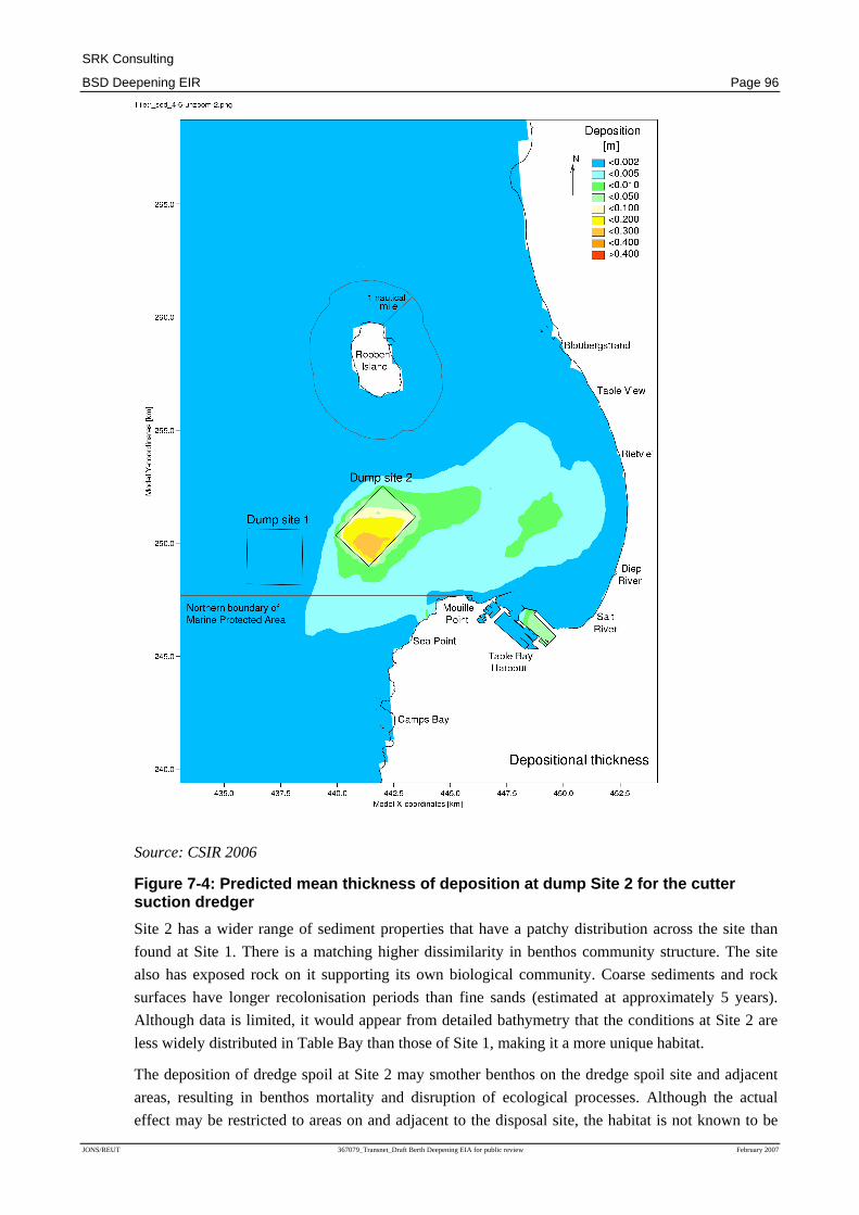
The 'worst case' average deposition pattern which would once again result from dredge spoil
discharge during the use of a cutter suction dredger (based on simulation modelling undertaken by
CSIR, 2006), at Site 2, is depicted in Figure 7-4. Similar to Site 1, the bulk of the discharged
sediment is contained within the designated disposal site. However, there is an extensive area outside
the disposal site where deposition of sediment occurs, albeit in shallow layers (<1cm thick). Some of
this deposition extends into the coast adjacent and south of Mouille Point, in the Table Mountain
National Park MPA.
SRK Consulting
BSD Deepening EIR Page 96
JONS/REUT 367079_Transnet_Draft Berth Deepening EIA for public review February 2007
Source: CSIR 2006
Figure 7-4: Predicted mean thickness of deposition at dump Site 2 for the cutter suction dredger
Site 2 has a wider range of sediment properties that have a patchy distribution across the site than
found at Site 1. There is a matching higher dissimilarity in benthos community structure. The site
also has exposed rock on it supporting its own biological community. Coarse sediments and rock
surfaces have longer recolonisation periods than fine sands (estimated at approximately 5 years).
Although data is limited, it would appear from detailed bathymetry that the conditions at Site 2 are
less widely distributed in Table Bay than those of Site 1, making it a more unique habitat.
The deposition of dredge spoil at Site 2 may smother benthos on the dredge spoil site and adjacent
areas, resulting in benthos mortality and disruption of ecological processes. Although the actual
effect may be restricted to areas on and adjacent to the disposal site, the habitat is not known to be

SRK Consulting
BSD Deepening EIR Page 97
JONS/REUT 367079_Transnet_Draft Berth Deepening EIA for public review February 2007
widely distributed in Table Bay and/or the wider region. The fact that deposition will extend into
Table Bay may also affect low relief emergent rock surfaces evident in detailed bathymetric charts of
the area. As a result the impact would be considered to be of regional significance.
Although some organisms may burrow to the surface, burial depths may prevent this on the dump
site itself. This would result in a reduction in biomass and the community structure being altered.
Deposition depths outside of the dump site are insignificant but the seafloor in this area may be rock
rather than sand, and deposition of sediment may thus alter the biological structure on these surfaces.
The duration of these impacts would be medium term, with rocky environments requiring a recovery
time of approximately 5 years.
As no mitigation can be recommended to reduce the significance of these impacts, other than not
making use of this site for disposal of dredge spoil, no assessment of the impact with mitigation has
been provided.
Table 7-13: Significance of the potential effects o f sediment deposition on benthic macrofauna at dredge disposal Site 2
Extent Intensity Duration Consequence Probability Significance Status Confidence
Without mitigation Regional
2 Medium 2
Medium-term 2
Medium 6
Probable MEDIUM -ve High
With mitigation n/a n/a n/a n/a n/a n/a n/a n/a
The significance of the potential effects of sediment deposition on benthic macrofauna at dredge
disposal Site 2 is therefore rated as medium.
Impact 6: Alteration of benthic biological communities through toxins associated with dredge
spoil
The dredge spoil is characterised by trace metal concentrations higher than the London Convention
special care (action level) thresholds and threshold effect levels (TEL), although they do not exceed
the prohibition thresholds (i.e. levels above which they may not be disposed of at sea). Dredge spoil
therefore has the potential to alter benthos community structure on the site used for spoil disposal
and immediately adjacent areas, as a result of the contamination of the sediments.
The toxicity potential of the dumped sediments depends on the bioavailability of trace metals which
are expected to be limited due to probable adsorption to iron (ferric) and manganese (manganous)
hydroxides present in the now oxic sediments (and based on elutriation tests undertaken). Trace
metals should thus remain in the particulate phase.
If the sediment is sufficiently toxic to cause adverse effects, the toxicity is likely to be relatively
rapidly dissipated by wave generated resuspension and advection of silt and clay sized particles
away from the dump site area (having a dilution effect, and thus reducing the possibility of toxic
effects). Re-deposition of these sediments away from the dump site should be sufficiently small to
mitigate any latent toxicity. Therefore any toxic effects on biota in and adjacent to the dump site
should be worked out of the community within a few generations.
The probability of toxic effects occurring are considered to be low, as there is only a single instance
of a trace metal in the sediments to be dredged exceeding the probable effect level (PEL), and this
SRK Consulting
BSD Deepening EIR Page 98
JONS/REUT 367079_Transnet_Draft Berth Deepening EIA for public review February 2007
should be reduced below this threshold once disposed of through dilution with less contaminated
sediments and the spoil dumping process.
Because of differing benthos community structure in the two potential dredge disposal sites
implications of potential toxic effects would differ, and the significance of the potential impact on
these two sites have therefore been assessed separately.
Site 1
As the sediment deposition at Site 1 will largely be limited to the immediate area of the dump site, as
indicated in Figure 7-2 the extent of the potential toxic effects on benthic biological communities
impacts would be local. The significance of this impact is considered to be very low, due to the
spatial and temporal extent of any effect being small relative to the amount of similar habitat in
Table Bay and no mitigation measures are considered necessary or feasible. No assessment of this
impact with mitigation has thus been provided.
Table 7-14: Significance of the potential alteratio n of benthic biological communities through toxins in dredge spoil at Site 1
Extent Intensity Duration Consequence Probability Significance Status Confidence
Without mitigation
Local 1
Low 1
Short-term 1
Very Low 3
Improbable VERY LOW -ve High
With mitigation
n/a n/a n/a n/a n/a n/a n/a n/a
The significance of the potential alternation of benthic biological communities through toxins in
dredge spoil at dredge disposal Site 1 is therefore rated as very low.
Note: Although the prescribed impact rating methodology results in a significance rating of
“insignificant”, based on the experience and opinion of the specialists and EIA consultant, this
impact is considered to be of very low significance.
Site 2
The significance of this impact at Site 2 is considered to be higher than at Site 1. Although the actual
effect may be restricted to the areas in and adjacent to the dredge disposal site, the habitat existing at
this site may not be widely distributed in Table Bay and/or the wider region, and the influence of this
impact occurring may thus be considered regional.
There is a potential biodiversity “loss” due to the possible uniqueness of the habitat in Table Bay and
the fact that only part of the area has sediment similar to that proposed for dumping. As no
mitigation, other than not making use of this site for disposal of dredge spoil, can be recommended
to reduce the significance of these impacts, no assessment of the impact with mitigation has been
provided.
Table 7-15: Significance of the potential alteratio n of benthic biological communities through toxins in dredge spoil at Site 2
Extent Intensity Duration Consequence Probability Significance Status Confidence
Without mitigation
Regional 2
Low 1
Short-term 1
Very Low 4
Improbable LOW -ve High
With mitigation
n/a n/a n/a n/a n/a n/a n/a n/a
The significance of the potential alternation of benthic biological communities through toxins in
dredge spoil at dredge disposal Site 2 is therefore rated as low.

SRK Consulting
BSD Deepening EIR Page 99
JONS/REUT 367079_Transnet_Draft Berth Deepening EIA for public review February 2007
Note: Although the prescribed impact rating methodology results in a significance rating of
“insignificant”, based on the experience and opinion of the specialists and EIA consultant, this
impact is considered to be of low significance.
Impact 7: Effects of turbidity generated by the dredge spoil dumping on habitats adjacent to the
dredge spoil dump area(s)
The suspended sediment concentrations thresholds applicable to the dredge spoil dump sites are
those of EMBECOM (2004). These identify exposures to 20mg/l for continuous periods of three
days or longer as the lower threshold of possible adverse ecological effects. Probable adverse effects
may be generated in exposures to 80mg/l but 100mg/l concentrations have proven negative impacts.
This assessment utilises 20mg/l suspended sediment as a low risk threshold and 100mg/l as the
upper permissible limit.
Simulation modelling of suspended sediment distributions in the surface layers of the water column
show that levels >20mg/l do not extend beyond the borders of either of the dredge spoil dump sites
for any of the dredging scenarios tested.
This is not the case for the bottom layer as shown in Figures 7.5 and 7.6. These are the 'worst case'
predictions and apply to the winter “combination cutter suction dredger and backhoe” scenario.
(Scenarios for “combination Trailing suction hopper dredger and backhoe” dredging operations are
slightly less severe but those for backhoe only dredging much smaller due to lower spoil dump
rates.)

SRK Consulting
BSD Deepening EIR Page 100
JONS/REUT 367079_Transnet_Draft Berth Deepening EIA for public review February 2007
Source: CSIR 2006a
Figure 7-5: Predicted exceedance (days) of 20mg/l o f suspended sediment within the bottom layer of the greater study area for the dred ge spoil dumped at Site 1 (worst case scenario)
Figure 7.5 indicates that turbid water near the sea floor may invade large areas of Table Bay; mostly
within a ~5km radius of the centre of disposal Site 1 but there is also a patch of longer exceedances
of the 20mg/l threshold in inner Table Bay, north of the harbour entrance. Exceedances in these
areas are predicted to be >15<30 days indicating a strong likelihood that exposure durations may be

SRK Consulting
BSD Deepening EIR Page 101
JONS/REUT 367079_Transnet_Draft Berth Deepening EIA for public review February 2007
longer than three days. There is therefore a possibility of deleterious impacts within these areas. The
number of days when the threshold is exceeded outside of these areas is low (2-5 days) and durations
in excess of 3 days are considered to be unlikely with a low probability of deleterious effects.
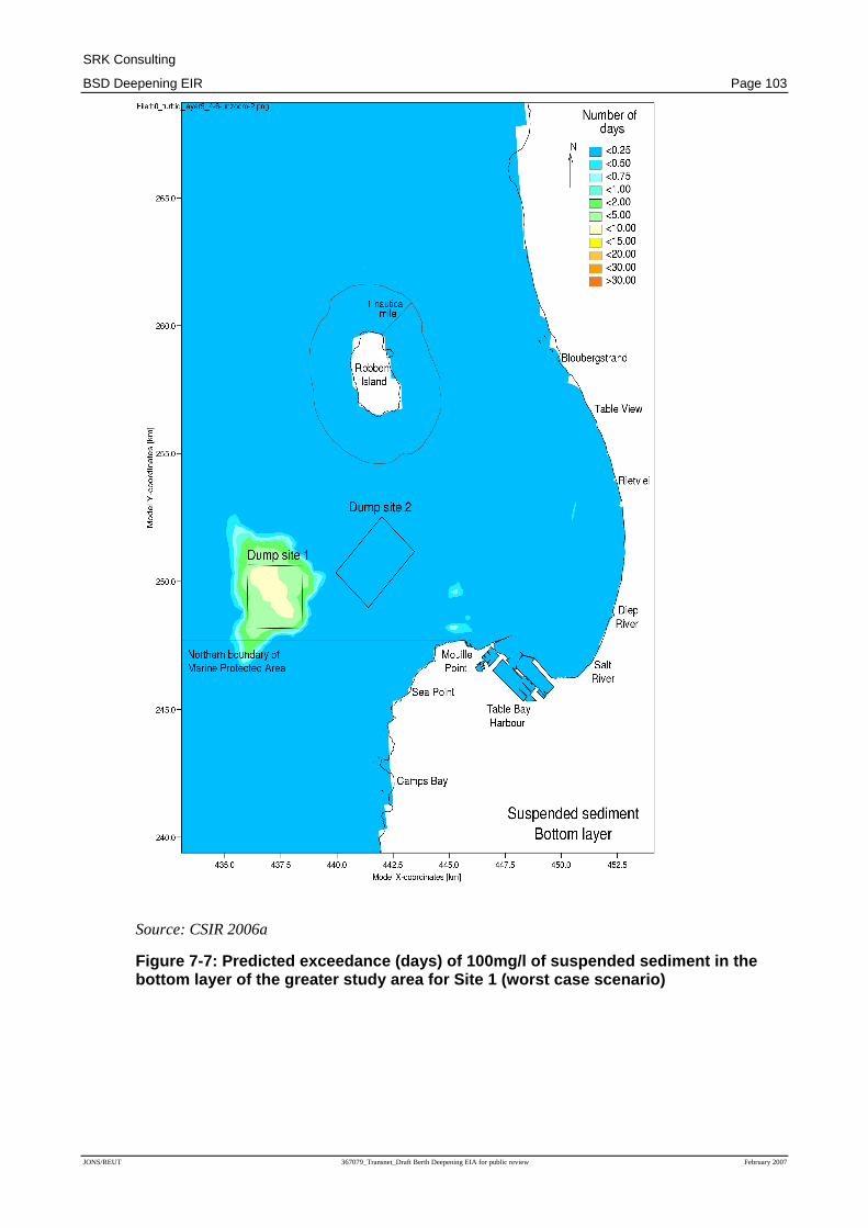
Sediments disposed of at dredge disposal Site 2 have a far greater area of impact and higher days of
exceedance than at disposal Site 1, as indicated in Figure 7.6.
Source: CSIR 2006a
Figure 7-6: Predicted exceedance (days) of 20mg/l o f suspended sediment within the bottom layer of the greater study area for the dred ge spoil dumped at Site 2 (worst case scenario)

SRK Consulting
BSD Deepening EIR Page 102
JONS/REUT 367079_Transnet_Draft Berth Deepening EIA for public review February 2007
The simulation modelling predicts that a large proportion of the Table Bay seabed, and associated
biota, will be exposed to suspended sediment concentrations >20mg/l for >30 days. According to the
adopted thresholds of possible adverse ecological effects, disposal of dredge spoil at Site 2 under this
scenario therefore has negative implications for an appreciable proportion of the Table Bay benthos.
Whereas exceedance of the 20mg/l suspended sediment threshold for dredge spoil dumping at both
dump sites is extensive in Table Bay, that for the 100mg/l limit is not, being largely contained within
the site boundaries. However, the area affected is larger for Site 2 than for Site 1 (Figures 7.7 and
7.8) which is probably a function of depth differences. Therefore the areas of probable adverse
ecological effects of suspended sediments on benthos are mainly limited to the specific dump sites
and may be exerted on biota already compromised by inundation (as discussed above). However,
Site 2 has a larger area of probable effects associated with it, extending northwards towards Robben
Island.
SRK Consulting
BSD Deepening EIR Page 103
JONS/REUT 367079_Transnet_Draft Berth Deepening EIA for public review February 2007
Source: CSIR 2006a
Figure 7-7: Predicted exceedance (days) of 100mg/l of suspended sediment in the bottom layer of the greater study area for Site 1 ( worst case scenario)

SRK Consulting
BSD Deepening EIR Page 104
JONS/REUT 367079_Transnet_Draft Berth Deepening EIA for public review February 2007
Source: CSIR 2006a
Figure 7-8: Predicted exceedance (days) of 100mg/l of suspended sediment in the bottom layer of the greater study area for Site 2 ( worst case scenario)
Due to the apparent differences in areal scales of potential impacts of suspended sediments the two
dredge spoil dump sites are assessed separately.
Site 1
The negative effects of turbid plumes as a result of dredge spoil disposal at Site 1 would be local,
largely restricted to within an approximately 5km radius of the centre of the spoil dump site but with

SRK Consulting
BSD Deepening EIR Page 105
JONS/REUT 367079_Transnet_Draft Berth Deepening EIA for public review February 2007
an isolated patch of longer exceedances immediately north of the harbour entrance. Durations of
exceedances of concentrations above the 20mg/l threshold outside of these areas are probably <3
days and concentrations >100mg/l are predicted to be restricted to the dump site and immediately
adjacent areas.
The effects of turbidity on habitats is expected to be short-lived, with recovery commencing on
completion of the dredging programme, and largely attained within 1-3 years. Due to the small
spatial extent of the effects relative to the amount of similar habitat in Table Bay and the expected
rapid recolonisation, this impact is considered to be insignificant, and no mitigation is required.
Table 7-16: Significance of the potential effects o f turbidity from dredge spoil disposal on habitats adjacent to Site 1
Extent Intensity Duration Consequence Probability Significance Status Confidence
Without mitigation
Local 1
Low 1
Short-term 1
Very Low 3
Possible INSIGNIFICANT -ve High
With mitigation
n/a n/a n/a n/a n/a n/a n/a n/a
The significance of the potential effects of turbidity from the disposal of dredge spoil on habitats
surrounding the dredge disposal Site 1 is therefore rated as insignificant.
Site 2
The negative effects of turbid plumes as a result of dredge spoil disposal at Site 1 would be
Regional; as a large proportion of the Table Bay sea floor will be exposed to suspended sediment
concentrations above 20mg/l for periods exceeding the set three days of continuous exposure limit
and concentrations >100mg/l are predicted to affect the seabed north of the dump site itself.
The effects may lead to temporary shifts in community structure, which may have implications for
biodiversity because of the diversity of habitats that may be affected.
The impact is considered to be of medium significance, as the potential spatial extent of the impact is
large relative to the known distributions of habitat types and Table Bay itself. However,
recolonisation should be rapid. No viable essential mitigation measures have been identified to
reduce the significance of this impact (other than not making use of this disposal site), and no
assessment with mitigation has been provided.
Table 7-17: Significance of the potential effects o f turbidity from dredge spoil disposal on habitats adjacent to Site 2
Extent Intensity Duration Consequence Probability Significance Status Confidence
Without mitigation
Regional 2
Medium 2
Short-term 1
Low 5
Probable MEDIUM -ve Medium
With mitigation n/a n/a n/a n/a n/a n/a n/a n/a
The significance of the potential effects of turbidity from the disposal of dredge spoil on habitats
surrounding the dredge disposal Site 2 is therefore rated as medium.
Note: Although the prescribed impact rating methodology results in a low significance rating, based
on the experience and opinion of the specialists and EIA consultant, this impact is considered to be
of medium significance.

SRK Consulting
BSD Deepening EIR Page 106
JONS/REUT 367079_Transnet_Draft Berth Deepening EIA for public review February 2007
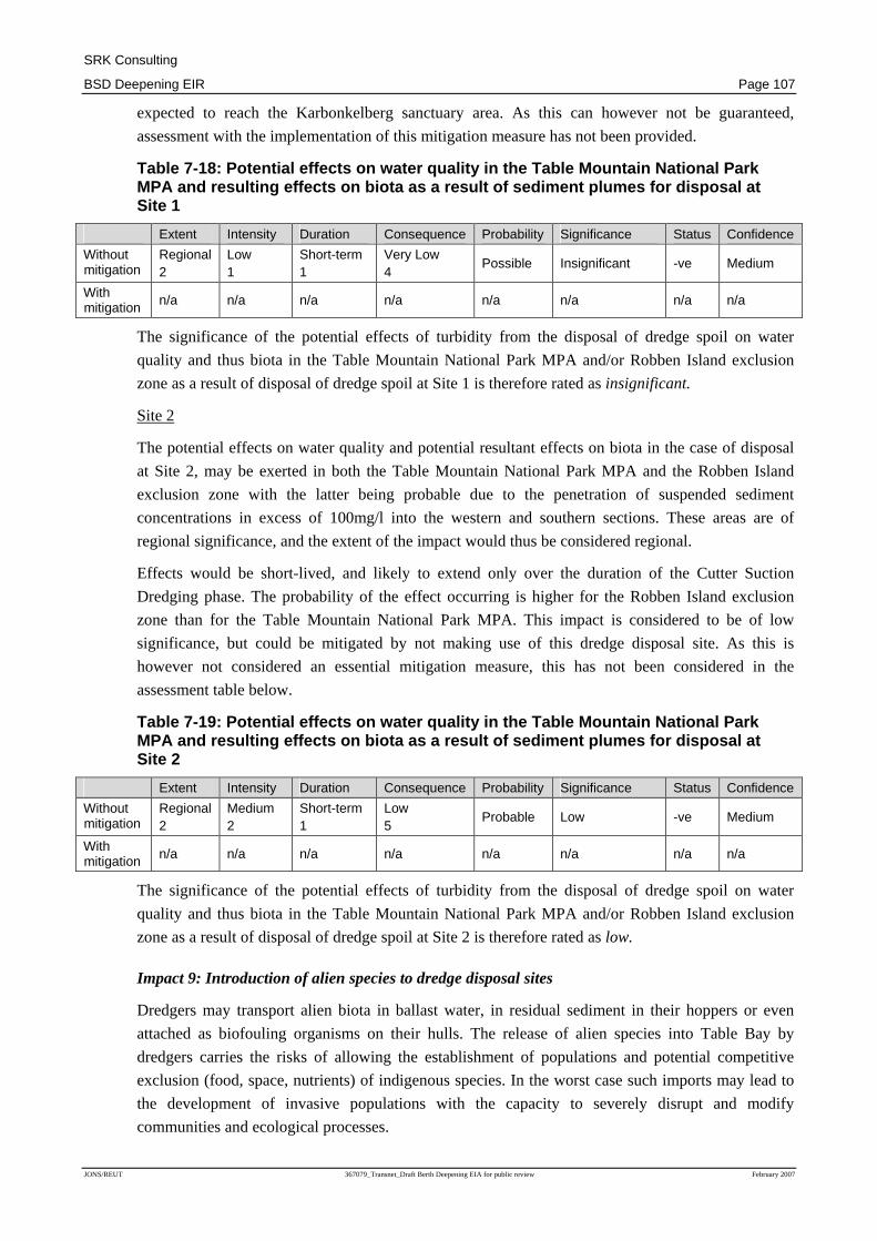
Impact 8: Effects on water quality in the Table Mountain National Park Marine Protected Area
and resulting effects on biota as a result of sediment plumes
Simulation modelling of the generation of sediment plumes as a result of the disposal of dredge spoil
indicate that in the worst case scenario (winter making use of the cutter suction dredger), suspended
sediment concentrations greater than the 20mg/l possible effect threshold may invade the bottom
waters of the Table Mountain National Park MPA and the Robben Island exclusion zone, as
indicated in Figures 7-5 and Figure 7-6 respectively.
Suspended sediment concentrations >100mg/l (the probable effect level) are predicted not to extend
into the Table Mountain National Park MPA for sediments discharged at dredge disposal Site 1 for
longer than a day30 (Figure 7.7) but may well do so for spoil discharged at Site 2 (Figure 7.8) with
respect to the Robben Island exclusion zone. This is not expected to occur for Cutter Suction
Dredger operations in summer or for any of the other dredging scenarios tested.
The predicted 'worst case' simulated time series of bottom water suspended sediment concentrations
at 0.5 km and 1 km south of the northern boundary of the MPA for both dredge spoil disposal sites
show that, for disposal at Site 1, there are two occurrences of suspended sediment concentrations in
excess of 20mg/l that have durations in excess of three days immediately south of the dump site. The
durations are similar at the 0.5 km and 1 km locations but peak concentrations are higher deeper into
the MPA. Exceedances southwest of Site 2 are marginal and short lived. The maximum exposure
period in the simulations appears to be ~seven days.
For dredge disposal at Site 2, there will be less frequent occurrences of suspended sediment
concentrations >20mg/l and none of these are predicted to have durations in excess of three days.
For disposal at either of the sites, suspended sediment concentrations >20mg/l are predicted to
extend into the Karbonkelberg sanctuary area within the Table Mountain National Park MPA
(Figures 7.5 and 7.6). However, the number of days of exceedance is low at less than two days for
Site 1 and less than five days for Site 2. The three day duration threshold will not be transgressed for
the latter dump site.
The potential impact of high suspended sediment concentration water invading the Table Mountain
National Park MPA and/or the Robben Island exclusion zone for the two dredge spoil disposal sites
is assessed separately for the dump sites below.
Site 1
Although the potential effects on water quality in the Table Mountain National Park MPA and/or
Robben Island exclusion zone, and potential resultant effects on biota would be limited to the
northern area of the Table Mountain National Park MPA, these would be considered of regional
extent, due to the regional importance of the MPA.
Effects would be short-lived, and likely to extend only over the duration of the Cutter Suction
Dredging phase. This impact is thus considered to be insignificant. Undertaking dredging with
Cutter Suction Dredgers during summer would however reduce the impacts, as the penetration of
>20mg/l suspended sediment load into the Table Mountain National Park MPA is reduced, and is not
30 It should be noted that durations of sediment plumes are related to total duration associated with multiple
sediment disposal events within a 90 day period.
SRK Consulting
BSD Deepening EIR Page 107
JONS/REUT 367079_Transnet_Draft Berth Deepening EIA for public review February 2007
expected to reach the Karbonkelberg sanctuary area. As this can however not be guaranteed,
assessment with the implementation of this mitigation measure has not been provided.
Table 7-18: Potential effects on water quality in t he Table Mountain National Park MPA and resulting effects on biota as a result of s ediment plumes for disposal at Site 1
Extent Intensity Duration Consequence Probability Significance Status Confidence
Without mitigation
Regional 2
Low 1
Short-term 1
Very Low 4
Possible Insignificant -ve Medium
With mitigation n/a n/a n/a n/a n/a n/a n/a n/a
The significance of the potential effects of turbidity from the disposal of dredge spoil on water
quality and thus biota in the Table Mountain National Park MPA and/or Robben Island exclusion
zone as a result of disposal of dredge spoil at Site 1 is therefore rated as insignificant.
Site 2
The potential effects on water quality and potential resultant effects on biota in the case of disposal
at Site 2, may be exerted in both the Table Mountain National Park MPA and the Robben Island
exclusion zone with the latter being probable due to the penetration of suspended sediment
concentrations in excess of 100mg/l into the western and southern sections. These areas are of
regional significance, and the extent of the impact would thus be considered regional.
Effects would be short-lived, and likely to extend only over the duration of the Cutter Suction
Dredging phase. The probability of the effect occurring is higher for the Robben Island exclusion
zone than for the Table Mountain National Park MPA. This impact is considered to be of low
significance, but could be mitigated by not making use of this dredge disposal site. As this is
however not considered an essential mitigation measure, this has not been considered in the
assessment table below.
Table 7-19: Potential effects on water quality in t he Table Mountain National Park MPA and resulting effects on biota as a result of s ediment plumes for disposal at Site 2
Extent Intensity Duration Consequence Probability Significance Status Confidence
Without mitigation
Regional 2
Medium 2
Short-term 1
Low 5
Probable Low -ve Medium
With mitigation n/a n/a n/a n/a n/a n/a n/a n/a
The significance of the potential effects of turbidity from the disposal of dredge spoil on water
quality and thus biota in the Table Mountain National Park MPA and/or Robben Island exclusion
zone as a result of disposal of dredge spoil at Site 2 is therefore rated as low.
Impact 9: Introduction of alien species to dredge disposal sites
Dredgers may transport alien biota in ballast water, in residual sediment in their hoppers or even
attached as biofouling organisms on their hulls. The release of alien species into Table Bay by
dredgers carries the risks of allowing the establishment of populations and potential competitive
exclusion (food, space, nutrients) of indigenous species. In the worst case such imports may lead to
the development of invasive populations with the capacity to severely disrupt and modify
communities and ecological processes.

SRK Consulting
BSD Deepening EIR Page 108
JONS/REUT 367079_Transnet_Draft Berth Deepening EIA for public review February 2007
The potential exists for importing alien species to the dredge disposal site, although this risk should
be limited to the first spoil dump events. After these any alien species that may have been in the
hoppers should have been released. There is an existing risk of this occurring due to current vessels
entering Table Bay, however the existing risk may not be specifically linked to the proposed dredge
disposal sites.
The import and release of alien species by dredgers and their establishment at and/or adjacent to the
dredge spoil disposal area would have a similar effect at either of the two sites being considered, and
a single assessment is thus valid for both sites.
This impact, should it occur, would be considered to be of local to regional (within Table Bay) and
possibly national significance. Once established it is unlikely that alien species would be obliterated
by natural processes of competition, predation etc, and the impact would thus be expected to have
long-term to permanent effects.
The probability of this impact occurring (although not the significance) can be reduced through the
application of the applicable ballast water management protocols stipulated in the IMO International
Convention for the Control and Management of Ship’s Ballast Water and Sediments, which have
been shown to reduce viable organisms by 95%, as well as the relevant requirements of NPA’s
Ballast Water Management Plan. Although the probability of the impacts occurring would be
reduced, it must be noted that ballast water treatment measures would not address the risk resulting
from residual sediments in these vessels. Rigorous flushing and washing of both dredger and barge
hoppers may constrain the risks here but it is not clear how this can be achieved.
Table 7-20: Significance of the potential importati on of alien species by dredgers and associated ecological effects at dredge disposal si tes
Extent Intensity Duration Consequence Probability Significance Status Confidence
Without mitigation
Regional 2
Medium 2
Long-term 3
High 7
Possible MEDIUM -ve Medium
With mitigation
Regional 2
Medium 2
Long-term 3
High 7
Improbable MEDIUM -ve Medium
The significance of the potential importation of alien species by dredgers and associated ecological
effects at the dredge disposal site is therefore rated as medium.
Impact 10: Effects of turbidity generated during dredge spoil dumping on endangered coastal
seabirds, specifically the African Penguin Spheniscus demersus
The African Penguin (included in the red data list of endangered species) forages in the areas of the
proposed dredge spoil dump sites and there is a breeding colony on Robben Island. A marked
decline in the global breeding population size from ~22 000 pairs in 1987 – 2001 to ~11 000 pairs in
2003 – 2006 has occurred recently. This has placed the African Penguin population in a precarious
situation in terms of its survival in the wild and potential disturbances on penguins therefore have to
be strictly guarded against.
Penguins are visual hunters and reduced visibility in the upper water column can reduce foraging
success, although it is unknown at what level turbidity begins to influence foraging. However, for
the purposes of this assessment a lower concentration limit of 10mg/l total suspended solids above
background in surface waters, i.e. the concentration at which the associated plume becomes visible is
considered to be the threshold which begins to interfere with penguin foraging.

SRK Consulting
BSD Deepening EIR Page 109
JONS/REUT 367079_Transnet_Draft Berth Deepening EIA for public review February 2007
The predicted 'worst cases' for upper water column turbidity for the proposed dredge spoil disposal
at both dump sites indicate that 10mg/l suspended sediment concentrations will be exceeded for <5
days in the immediate vicinity of the dump sites and an area immediately north of Mouille Point.
These are small proportions of the proposed dredging period and the water surface in Table Bay.
Elevated turbidity levels are likely to be of short duration, but possible deleterious effects on the
local penguin population level could be long term to permanent due to the small population size. It
should however be noted that there are no explicit links between turbidity, foraging success and
population level effects and the level of confidence for the evaluation of this impact is thus low. In
such a case, however the precautionary approach needs to be taken.
Due to the small area affected in the case of disposal at either of the two potential dredge disposal
sites as well as the expected turbid plume dissipation rates the significance of this impact is rated as
low without mitigation. Essential under any interpretation of the application of the precautionary
principle embodied in NEMA and the Biodiversity Conservation Act of 2002, it is recommended
that care is taken to ensure that there is no chronic build up of turbidity in the area of the dredge
disposal site through allowing sufficient time for turbidity to disperse between dump events.
The implementation of this mitigation measure would reduce the intensity of the impact, thus
reducing the significance of the impact to very low. As the exact requirements in this regard cannot
be provided based on current information and the implementation of this mitigation measure cannot
be guaranteed, the assessment of this impact with mitigation has not been presented in the table
below.
Table 7-21: Significance of the potential effects o f turbidity during dredge spoil dumping on endangered coastal seabirds
Extent Intensity Duration Consequence Probability Significance Status Confidence
Without mitigation
Local 1
Medium 3
Short-term 1
Low 5
Improbable LOW -ve Low
With mitigation
n/a n/a n/a n/a n/a n/a n/a n/a
The significance of the potential effects of turbidity resulting during the disposal of dredge spoil at
either of the dredge spoil disposal sites on endangered coastal seabird, especially the African
Penguin, foraging in the area is thus rated as low.
Note: Although the prescribed impact rating methodology results in a very low significance rating,
based on the experience and opinion of the specialists and EIA consultant, as well as implementation
of the precautionary principle this impact is considered to be of low significance.
Impact 11: Potential erosion of shoreline as a result of dumping of dredge material
The potential effects of the project on shoreline stability in Table Bay would be limited to those
associated with disposal of the dredge spoil at the selected disposal site. Dredging activities are
contained within the Ben Schoeman Dock and are not expected to affect the local wave conditions or
shoreline of Table Bay.
The disposal of dredge spoil from the Ben Schoeman Dock at either of the potential dredge disposal
sites would result in changes to the character of the sea bed at the disposal site, including the depth,
depending on the height of the sediment mound created. Although initially assumed that a mound of
approximately 0.3m average height would result from the dredge spoil disposal, it is recognized that

SRK Consulting
BSD Deepening EIR Page 110
JONS/REUT 367079_Transnet_Draft Berth Deepening EIA for public review February 2007
given the uneven distribution of the dredge material, it is possible that there could be unevenness
leading to mound heights that exceed 0.3 m. It is anticipated that localised mounds with peaks of up
to 0.6 to 0.7 m could occur due to the nature of the proposed dredge spoil dumping and the difficulty
in obtaining an even distribution of sediments over the dump-site. This is unlikely to cause
problems if these are isolated and not too extensive.
A mound of material of this height could affect the shoreline as a result of the effect of wave
refraction. Variation in the bathymetry of the sea bed close to the shore, such as that which would
result from a mound of disposed material can affect both the height and direction of the waves
reaching the shoreline. Such changes in wave conditions could cause changes in the rate of
longshore sand transport, thus potentially affecting the average shoreline position, through erosion or
accumulation of sand on a seasonal basis or even on a longer timescale.
The dimensions of the mound would determine the effect of the wave refraction, while the longevity
of the mound would determine how long any wave refraction effects persist. Due to the distance of
the potential dredge disposal sites from the shoreline, it is not expected that disposed material would
affect the shoreline by serving as a source of sand.
Refraction effects resulting from a local change in bathymetry of the seabed diminish with distance.
Previous studies indicate that e.g. erosion in the order of 0.5m may be induced at a distance of up to
4km from the dredge dump site but would be negligible at a distance of 9km from the dump site.
Site 1
The results of an analysis of the potential effects of dredge disposal on the sandy beaches in Table
Bay indicated that minor erosion (on average 0.5m) could result from a sediment mound with a
height of 0.3m above the sea bed.
The effects of a mound in 40m depth (with an average elevation of 0.3m) were found (as described
below) for Site 2 to cause negligible shoreline erosion, and it can be inferred that a similar mound
dumped at a depth of ~65m would also have a negligible effect since the effects of refraction
diminish with water depth. Changes to longshore sediment transport that consequently could affect
shoreline stability (i.e. result in minor shoreline erosion and/or accretion) is much less likely for the
greater water depths at Site 1 than for the shallower Site 2.
As no impact is expected in the case of dredge spoil disposal at Site 1, no mitigation is considered
necessary.
Table 7-22: Significance of the potential erosion o f the shoreline as a result of dredge disposal at Site 1
Extent Intensity Duration Consequence Probability Significance Status Confidence
Without mitigation
None 0
None 0
None 0
Not Significant Improbable INSIGNIFICANT neutral High
With mitigation n/a n/a n/a n/a n/a n/a n/a n/a
The significance of the potential erosion of the shoreline as a result of dredge disposal at Site 1 is
thus rated as insignificant.

SRK Consulting
BSD Deepening EIR Page 111
JONS/REUT 367079_Transnet_Draft Berth Deepening EIA for public review February 2007
Site 2
The results of an analysis of the potential effects of dredge disposal on the sandy beaches in Table
Bay indicated that minor erosion (on average 0.5m) could result from a sediment mound with a
height of 0.3m above the sea bed.
However, recognizing that Site 2, at a depth of ~40m is about 9km from the sandy erodible
shoreline, the decay of wave refraction effects over this distance would result in negligible (i.e. in the
order of centimeters at most) erosion effects on the shoreline.
In the case of any effects occurring, these would be on a local scale, and considered to be of low
intensity with natural functions and processes on the beach, in terms of amenity, protection afforded
to property and structures and functioning of dune and beach ecosystems negligibly altered.
Any potential impacts which could occur would be expected to be of medium term duration. Any
minute shoreline erosion would become virtually non-existence within 2-15 years as a result of
erosion of the mound.
It should be noted that the assessment of this impact assumes an average conservative mound height
of 0.3m, although the possibility of isolated peaks is recognised. Isolated peaks in mound height
above this elevation are unlikely to affect wave conditions, provided that these peaks are limited in
number and size.
Mitigation of possible erosion, which would be in the order of centimeters if it occurred, would not
be considered essential. The only practical means of mitigation would be the periodic supply of
sand to the beach. It is very likely that sufficient sand of suitable size characteristics would be
available to mitigate a minor erosion effect if desired, thus eliminating the impact. As this mitigation
can however not be guaranteed, the assessment of this impact with mitigation has not been presented
in the table below.
Table 7-23: Significance of the potential erosion o f the shoreline as a result of dredge disposal at Site 2
Extent Intensity Duration Consequence Probability Significance Status Confidence
Without mitigation Local
1 Low 1
Medium-term 2
Very Low 4
Possible INSIGNIFICANT -ve High
With mitigation
n/a n/a n/a n/a n/a n/a n/a n/a
The significance of the potential erosion of the shoreline as a result of dredge disposal at Site 2 is
thus rated as insignificant.
7.3.3.3 Impacts on existing uses in Table Bay
Impact 12: Potential deposition of sediments from dredging operations in existing dredge areas
and/or navigation channels
There is a concern that the dredge material disposed of at the dredge disposal sites may be
transported into the bay and be deposited in existing dredge areas and/or navigation channels, thus
requiring a degree of maintenance dredging to maintain channel depths. The model results however
indicate this impact to be small and greatly reduced in winter, when little or no sediments are
predicted to settle in the entrance channel to the Port of Cape Town.

SRK Consulting
BSD Deepening EIR Page 112
JONS/REUT 367079_Transnet_Draft Berth Deepening EIA for public review February 2007
Model simulations of the movement of sediments in the Port during dredging and around the
potential dredge disposal sites as a result of disposal of dredged material indicate that deposition in
the outer extremity of the port entrance channel does not exceed 1cm in the case of disposal of
dredge spoil at Site 1 and 5cm for disposal at Site 2.
Closer to the harbour entrance sedimentation does not exceed 0.5cm for disposal at Site 1 and 1cm
for disposal at Site 2. These are however considered to be conservative estimates (i.e. are expected to
be lower than estimated). As the sediments will continue to the redistributed for an extended period
of time, the duration of this impact is considered to be medium term.
Although long term changes to navigation channels and dredge areas within the bay cannot be
accurately estimated based on the short simulations (resulting in low to medium confidence), the
probability of substantial movement of materials other than muds towards the port entrance channel
is greatly reduced for Site 1 compared to Site 2, although the impact ratings would be considered
similar. A single assessment table, applicable to both disposal sites has thus been provided.
No mitigation measures can be implemented for this potential impact, other than maintenance
dredging of the potentially affected areas, if considered necessary. As such dredging is not
considered essential, or proposed as part of the current project, an assessment assuming the
implementation of this mitigation measure has not been provided.
Table 7-24: Significance of the potential depositio n of sediments from the dredging operations in existing dredge areas and/or navigati on channels
Extent Intensity Duration Consequence Probability Significance Status Confidence
Without mitigation
Local 1
Medium 2
Medium-term 2
Low 5
Probable LOW -ve Low to medium
With mitigation
n/a n/a n/a n/a n/a n/a n/a n/a
The significance of the potential deposition of sediments from the dredging operations in existing
dredge areas and/or navigation channels is thus rated as low.
Impact 13: Interference with existing shipping
During the intensive dredging operations, between 8 to 10 hopper barge loads per day will be
moving between the dredger in the harbour and the dredge disposal site.
As a result of the increase number of barges moving between the port and the dredge spoil site, there
is a risk that this would interfere with existing shipping traffic entering and exiting the port, as well
as increase the risk of collision between vessels. Furthermore there is a remote possibility that there
may be break-down (e.g. stuck hopper doors) that would result in the hopper barges occupying the
navigational channels and entrance to the port and, in so doing, interfere with other ships making use
of the port.
The potential impact is local in scale; however, should there be a collision of vessels, the
consequences could be regional. Consultations with the South African Maritime Safety Association
and the Port Captain have indicated that the proposed dump sites, while carrying some risk in terms
of shipping (particularly in the case of dredgers or hopper barges breaking down) are acceptable and
that the associated risks can be managed.

SRK Consulting
BSD Deepening EIR Page 113
JONS/REUT 367079_Transnet_Draft Berth Deepening EIA for public review February 2007
Existing port shipping management systems should allow for the movement of vessels to be suitably
managed, resulting in an impact of very low, which would be limited to the duration of the dredge
operations. No mitigation would be required to reduce this impact, and an assessment with
mitigation has thus not been provided in the table below.
Table 7-25: Significance of the potential interfere nce with existing shipping
Extent Intensity Duration Consequence Probability Significance Status Confidence
Without mitigation
Local 1
Low 1
Short-term 1
Very Low 3
Definite VERY LOW -ve High
With mitigation
n/a n/a n/a n/a n/a n/a n/a n/a
The significance of the potential interference with existing shipping is thus rated as very low.
7.3.4 Cumulative Impacts on the Marine Environment
The proposed dredging operations will take place in a high shipping traffic working port that
receives contaminants from ship operations, bunkering, urban stormwater flows and ship repairs
amongst other sources. The port can therefore not be considered as a 'pristine' environment in any
sense and it probably does not have any functional ecological links with Table Bay, aside from
providing rock lobster habitat on the outer port structures. Therefore disturbances associated with the
proposed dredging within the port are considered to be unlikely to exert any cumulative effects on
the already compromised ecological functioning of the harbour, or in Table Bay. Further, possible
cumulative effects on the natural environment associated with increased shipping in the Table Bay
area are likely to be negligible and not discernible within the range of effects already generated by
the high shipping traffic. None of these possible effects are considered further here.
Table Bay receives effluent from stormwater flows and rivers draining the urban catchment of Cape
Town, the Chevron/Caltex outfall at Milnerton and the Green Point and Robben Island outfalls that
discharge primarily domestic effluent. Despite the pollution loads any ecological effects in the
subtidal areas of Table Bay would appear to be limited as evidenced by environmental surveys
conducted for the Chevron/Caltex outfall and the benthos community distributions determined in this
assessment (above). Transferring contaminated sediment from the proposed dredge area to one of the
candidate dredge spoil dump sites would add to this pollution load. Effects may be expressed at the
dredge spoil dump site through long term (> 5 years) modification of benthos community structure
or in the build up of contaminants in important components of the local benthic food chain such as
mussels. The system-wide ecological consequences of this remain unknown, however and cannot be
assessed with any degree of confidence.
7.3.5 Recommended Mitigation Measures: Potential Ma rine Impacts
Essential mitigation measures include:
1. Apply the relevant ballast water management protocols stipulated in the IMO International
Convention for the Control and Management of Ship's Ballast Water and Sediments as well as
NPA requirements for ballast water management, with verification of application; and
2. Dispose of dredged material in such a way that an average mound elevation of 0.3m is achieved
in order to prevent unexpected wave refraction effects occurring, particularly at Site 2.

SRK Consulting
BSD Deepening EIR Page 114
JONS/REUT 367079_Transnet_Draft Berth Deepening EIA for public review February 2007
3. Include specifications of turbidity levels not to be exceeded at the entrance/exit to Ben
Schoeman Dock in the Environmental Management Plan and Dredge Tender documents.
Recommended levels are likely to range from 80 to 100mg/l, but will need to be both reasonable
and sufficiently conservative to mitigate specific predicted environmental impacts. It is best left
to the dredge operators to select appropriate mitigation measures to meet these specifications,
rather than specifying these in the Environmental Management Plan. The EMP should however
make allowance for monitoring of these levels.
Optional mitigation measures include:
1. Lure seals, marine mammals and marine birds out of Ben Schoeman Dock to sea during blasting
periods.
2. Should a Cutter Suction Dredger be chosen, undertake dredging during summer rather than
winter;
3. Ensure that sediments are deposited in thin layers when discharged at the sediment disposal site,
in an attempt to achieve a fairly even sediment distribution, rather than mounds, to reduce
mortality of benthos;
4. Prevent the chronic build up of turbidity in the area of the dredge disposal site through allowing
sufficient time for turbidity to disperse between dump events, thus reducing impacts on penguin
populations foraging in the area;
5. Dispose of dredge spoil at Site 1 rather than Site 2;
6. In the case of Site 2 being selected as the dredge disposal site, undertake a limited wave
modelling study for this site, to confirm the effect of uneven dumping on the wave climate is
sufficiently limited to prevent changes in shoreline stability;
7. Reassess the potential impacts on the marine environment in the case of dredge technology,
nature of operations or durations being significantly different to those assessed in the specialist
study (based on current project description provided in Chapter 3);
8. Confirm the potential remobilization of toxins with additional (more comprehensive) elutriation
analyses of the sediments targeted to be dredged, prior to dredging;
9. If possible, find a beneficial use for rock to be removed from the basin;
10. Obtain an appropriate environmental baseline for the potential impacts from dredging operations
(e.g. water quality at the Two Oceans Aquarium intake). The baseline should specifically be
obtained for “indicator” trace metals (copper and zinc) and suspended sediments (and possibly
nutrient, particularly ammonium levels). These quantities are to be appropriately monitored at
the Two Oceans Aquarium during the dredging operations;
11. In the case of water quality at the intake point not being suitable for use by the aquarium and
attributable to dredging or dredge disposal activities, the implementation of mitigation measures
(e.g. running of a closed system, or obtaining seawater from elsewhere) should be considered;
Optional monitoring with respect to marine impacts include:
1. Utilise survey data gained on the candidate dump sites to track changes associated with dredge
spoil dumping over a realistic time span to show rates of benthos recovery and provide
information on dumped dredge spoil behaviour. Opportunities for this have not been created in

SRK Consulting
BSD Deepening EIR Page 115
JONS/REUT 367079_Transnet_Draft Berth Deepening EIA for public review February 2007
the past and the baseline data set will be an invaluable tool in understanding the effects and
implications of the marine disposal of dredge spoil on South Africa's inner continental shelf.
2. Undertake further simulation modeling analyses of the life cycles and distributions of dredge
spoil dump site surface layer turbidity plumes throughout the various phases of the dredging
programme. In terms of the possible effects on African Penguins foraging in Table Bay, this may
lead to mitigation solutions based on timing of the various phases of dredging and spoil
dumping. Although the evaluation of the predicted effects on penguins yielded a low
significance rating, public perceptions merit serious attention being given to efforts to ameliorate
any possible impacts.
3. Monitor beneficial use areas of the V&A waterfront such as filter performance levels at the Two
Oceans Aquarium and through real time monitoring (instrumented buoy and telecommunication
system) located near the entrance to the harbour. The buoy system would also allow real time
control of the dredging operations in terms of limiting exceedances of critical suspended
sediment concentrations such as those envisaged in EMBECON (2004).
4. Operate a mussel watch programme (through DEAT/MCM) that incorporates sampling points
around the Port of Cape Town. Sampling intervals in this programme are six months. During the
dredging period it is recommended that monthly coverage is requested to show short term
effects, if any, of remobilised contaminants in filter feeders. This monitoring can be augmented
by suspension of mussels adjacent to the selected dredge spoil dump site to confirm that
released or remobilised contaminants are below any level of concern.
5. Utilise the monitoring of the proposed dredging operation, together with supplementary
measurements, to better constrain uncertainties in the model predictions. In particular,
measurements supporting the more accurate specification of critical shear stresses of deposition,
critical shear stresses of erosion and re-suspension rates at the seabed, should be taken.
7.4 Potential Noise, Shock and Vibration Impacts
7.4.1 Noise, Shock and Vibration Study Introduction , Terms of Reference and Methodology
This section of the report is based on the Noise and Vibration Impact Assessment, attached as
Appendix D, which was undertaken by Demos Dracoulides and Associates (DDA).
The purpose of the Noise and Vibration Impact Assessment was to estimate the noise emissions and
vibration associated with the proposed construction and dredging operations and assess the
associated impacts on the adjacent areas and communities.
• Specific terms of reference for the noise and vibration study were to:
• Identify the most significant sources of noise vibration and shock during the construction and
operation of the proposed project (including frequency and nature of these noises);
• Identify the main receptors for noise impacts (e.g. surrounding communities and businesses);
• Analyse noise impacts on the ambient (current) noise environment;
• Assess the impacts of vibration and shock on existing port infrastructure;

SRK Consulting
BSD Deepening EIR Page 116
JONS/REUT 367079_Transnet_Draft Berth Deepening EIA for public review February 2007
• Assess the cumulative impacts of noise associated with simultaneous construction activities from
the BSD and berth upgrade; and
• Provide general recommendations for the mitigation of the noise and vibration impacts.
The approach for the noise study incorporated the measurement of daytime and night-time ambient
noise at six locations, five within the perimeter of the port and one in the adjacent Zonnebloem
residential area, since it has a direct line of sight with the BSD, where the construction activities will
take place.
The noise levels within and around the port area, due to all the construction equipment and
operations, were estimated with the use of the internationally accepted MITHRA prediction software
package. The determination of the sound power levels for the various equipment to be used during
the construction operations were based on:
• the latest update of the equipment database included in the British Standard 5228: Part 1: 1984
“Noise Control on Construction and Open Sites Part 1: Code of Practice for Basic Information
and Procedures for Noise Control” and
• measurements taken by the consultants at various construction sites.
The impact of noise in the areas surrounding the site was assessed in terms of the difference between
the existing measured or typical noise levels in that area and the predicted levels for the
construction/dredging activities. This difference was assessed in accordance with the guidelines
provided in the SANS Code of Practice 10103:2004 “The measurement and rating of environmental
noise with respect to annoyance and to speech communication”, as well as the noise regulations
applicable to the Western Cape (DEAT, 1998). The latter regulations define noise as ‘disturbing’ if
it causes the ambient noise level to increase by 7 dBA or more over an area’s typical noise level, as
designated in SANS 10103 or as otherwise designated by the local authority.
As a worst-case scenario, it was assumed that equipment utilised for the quay wall extension and
berth deepening and the dredging of the basin will operate simultaneously. In addition to the main
construction operations, the noise from material handling at the Contractors’ Yard31 was also taken
into consideration.
The assessment of impacts associated with vibrations related to blasting and other construction
activities such as piling was more qualitative. Potential impacts associated with underwater blasting
as a result of ground vibrations, watershock (an explosive shock wave with a steep leading edge,
followed by a number of secondary pulses caused by the expansion and collapse of the explosion gas
bubble), explosion gas bubble and airblast were taken into consideration in the report entitled
Removal of Rock in the Port of Cape Town (Szendrei et al, 2006) which investigated the different
methods of breaking rock, and determine the need for blasting. These potential impacts informed the
proposed blasting regime (as described in Section 3.2.2) based on which the impacts of blasting have
been assessed.
31 For the purposes of the noise impact assessment it was assumed that the Contractors Yard will be situated on
the Culemborg Site.
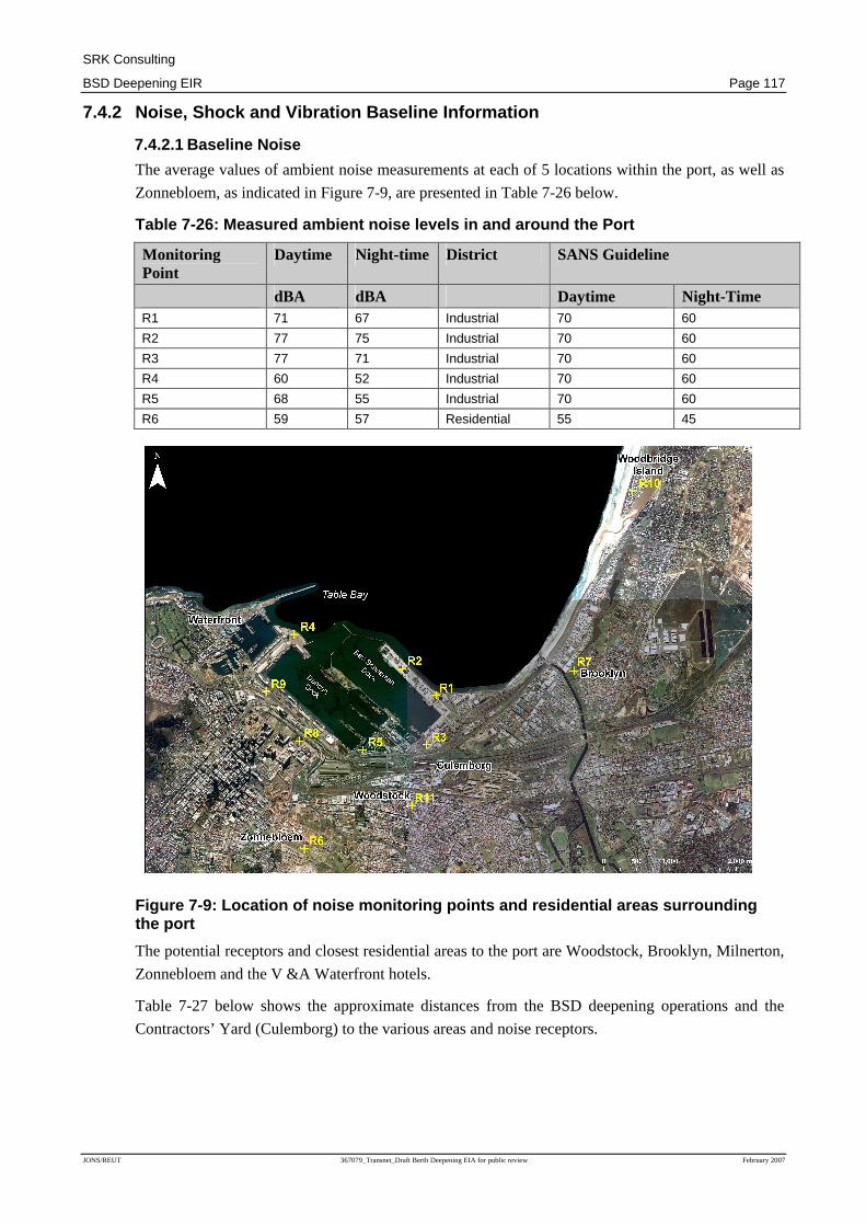
SRK Consulting
BSD Deepening EIR Page 117
JONS/REUT 367079_Transnet_Draft Berth Deepening EIA for public review February 2007
7.4.2 Noise, Shock and Vibration Baseline Informati on
7.4.2.1 Baseline Noise
The average values of ambient noise measurements at each of 5 locations within the port, as well as
Zonnebloem, as indicated in Figure 7-9, are presented in Table 7-26 below.
Table 7-26: Measured ambient noise levels in and ar ound the Port
Monitoring Point
Daytime Night-time District SANS Guideline
dBA dBA Daytime Night-Time R1 71 67 Industrial 70 60
R2 77 75 Industrial 70 60
R3 77 71 Industrial 70 60
R4 60 52 Industrial 70 60
R5 68 55 Industrial 70 60
R6 59 57 Residential 55 45
Figure 7-9: Location of noise monitoring points and residential areas surrounding the port
The potential receptors and closest residential areas to the port are Woodstock, Brooklyn, Milnerton,
Zonnebloem and the V &A Waterfront hotels.
Table 7-27 below shows the approximate distances from the BSD deepening operations and the
Contractors’ Yard (Culemborg) to the various areas and noise receptors.

SRK Consulting
BSD Deepening EIR Page 118
JONS/REUT 367079_Transnet_Draft Berth Deepening EIA for public review February 2007
Table 7-27: Distances of residential areas surround ing the port from the construction area
Area Land Use Distance (m) SANS Guideline
BSD Culemborg Daytime Night-Time
Woodstock Commercial / Residential 1,500 700 60 50
Brooklyn Residential 2,500 2,700 55 45
Zonnebloem Residential 2,550 2,250 55 45
Milnerton Residential 4,000 4,750 55 45
Woodbridge island Residential 4,500 5,200 55 45
V & A Waterfront Commercial / Residential 1,500 3,200 60 50
To the south of the port is the commercial and residential area of Woodstock. The distances from the
BSD and the Contractors’ Yard are 1.5 km and 0.7 km respectively. There are a variety of industries
in the area. The noise environment is dominated by local traffic on the main road network, rail
traffic as well as by industrial and commercial sources. The area can be characterised as ‘Urban
district with some workshops, with business premises, and with main roads’. In accordance with
SANS, the typical recommended ambient noise levels during the daytime and night-time are 60 dBA
and 50 dBA respectively.
The residential area of Brooklyn is situated approximately 2.5 km east of the proposed construction
operations. Brooklyn is shielded from the construction operations by the Paarden Eiland industrial
area. It is expected that the industrial buildings in Paarden Eiland will shield most of the noise from
the dredging operations. The current noise environment in this area is dominated by the N1
highway, Koeberg Road and Marine Drive traffic. According to the procedures specified in SANS
10103, the Brooklyn area can be described as an ‘Urban’ district, with typical daytime and night-
time noise levels of 55 dBA and 45 dBA respectively.
The Zonnebloem residential area is in direct line of sight to the BSD area. This means that the
construction operations could potentially have a negative impact on noise levels under certain
meteorological conditions. The area, however, is situated quite far from the port (approximately
2.5 km) and the current noise levels in Zonnebloem are quite high, i.e. exceeding the SANS
guideline for an ‘Urban’ district (see position R6 in Table 7-24). The noise levels in this area are
consistently around 58 dBA throughout the day- and night-time. The main contributors to these high
noise levels are local traffic, as well as traffic along the N1 and N2 highways and the existing port
operations.
Milnerton and Woodbridge Island residential areas are situated more than 4 km north-east of the
port. The present ambient noise climate is dominated by the waves breaking on the beach, as well as
traffic on Milner Drive and the local road network. Current noise levels are likely to exceed the
SANS guideline for an ‘Urban’ district.
The distance between the V & A Waterfront and the northern section of the BSD is approximately
1.5 km. There are a number of port buildings that could shield most of the Waterfront area from the
noise emissions of the dredging operations. Noise emissions from the current port activities, the
central business district and traffic on the local road network dominate the noise environment. The
area can be characterised as ‘Urban district with some workshops, with business premises, and with
main roads’, and is expected to have noise levels of 60 dBA and 50 dBA during day-time and night-
SRK Consulting
BSD Deepening EIR Page 119
JONS/REUT 367079_Transnet_Draft Berth Deepening EIA for public review February 2007
time respectively. This is also confirmed by the noise measurements performed at Point 4 (Figure 7-
9).
From Table 7-26 it is also evident that the highest noise levels were recorded in close proximity to
the current operations around the BSD, i.e. points R1 to R3. The existing noise environment in the
general port area is dominated by:
• The loading and offloading operations at the Duncan and Ben Schoeman Docks;
• Traffic along Duncan Road and Marine Drive;
• Traffic along the N1 and N2 highways; and
• Commercial activities in the Central Business District (CBD).
7.4.2.2 Baseline Vibrations
Unlike baseline noise levels, baseline vibration levels are almost always zero, or so small as to be
insignificant, and generally immeasurable. Unlike the assessment of noise impacts, which are related
to the change in noise levels, the assessment of vibrations is made on the actual predicted or
measured absolute vibration values, which is the parameter that causes disturbance to humans or
potential damage to buildings and marine animals. The baseline environment is therefore assumed to
be pristine, i.e. completely free of shock and vibration before construction and/or blasting
commences, and carrying out baseline measurements is not necessary or usual. Vibrations from
natural and normal activities, including container offloading, crane and ship movements, are small
compared to the energy of blasting.
7.4.3 Noise, Shock and Vibration Impact Assessment
Key impacts assessed in this section are:
• Potential Increase in noise levels; and
• Potential impacts of shock and vibration resulting from blasting.
These potential impacts are described and assessed in more detail in the following sub-sections (both
without and with the implementation of the mitigation measures listed in Section 7.4.4).
Impact 1: Potential Increase in Noise
The proposed dredging and construction activities in and around the Ben Schoeman Dock will
require the use of a variety of vehicles and equipment that could result in an impact on the noise
levels in the area. These would include dredge equipment and barges associated with the disposal of
dredge spoil, pile driver(s), pneumatic drills, concrete batching plants, as well as large trucks
transporting construction materials.
The impact of noise has been assessed in terms of the difference between the ambient (existing)
noise levels in the area and the predicted levels for the construction activities. While it is
acknowledged that existing port activities already generate noise it should be noted that since the
decibel (dB) scale used to measure noise levels is logarithmic rather than linear, two sources
producing the same level of noise would not result in the amount of noise being double in the case of
both producing noise simultaneously.

SRK Consulting
BSD Deepening EIR Page 120
JONS/REUT 367079_Transnet_Draft Berth Deepening EIA for public review February 2007
The human ear is not equally receptive to all frequencies of sound. The A-weighting of sound levels
is a method used to approximate how the human ear would perceive a sound, mostly by reducing the
contribution from lower frequencies by a specified amount. The unit for the A-weighted sound
levels is dBA.
Table 7-28 below provides an approximation of the resulting noise levels if the difference between
the levels of two sources is 1 to 10 or more decibels. For example, by removing a noise source that
individually generates 6 dBA below the ambient noise level, the resulting noise level reduction
would be 1 dB.
Table 7-28: Adding and subtracting noise levels
Difference between the two sound levels (dBA)
Quantity to be added to or subtracted from the higher level (dBA)
0 3
1 2.5
2 2.1
3 1.8
4 1.5
5 1.2
6 1
7 0.8
8 0.6
9 0.5
10 or more 0
Small changes in ambient sound levels will not be able to be detected by the human ear. Most
people will not notice a difference in loudness of sound levels of less than 3 dBA, which is a two-
fold change in the sound energy. A 10-dBA change in sound levels would be perceived as doubling
of sound loudness.
Figures 7-10 and 7-11 show the predicted noise contours around the proposed work areas during
daytime and night-time conditions, during the construction period, based on the noise levels
associated with the equipment to be used.

SRK Consulting
BSD Deepening EIR Page 121
JONS/REUT 367079_Transnet_Draft Berth Deepening EIA for public review February 2007
40
40
40
40
40
40
40
40
45
45
45
45
45
45
45
50
50
50
50
50
50
55
55
55
55
5560
60
60
65
65
65
70
75
R11
R9
R8
R7
R6
R5
R4
R3
R2
R1
N
0 1000m
dBA
BROOKLYN
WOODSTOCK
Source: DDA, 2006
Figure 7-10: Daytime noise contours during construc tion
As indicated on Figure 7-10, the 70 dBA noise contour, which represents the industrial district
guideline, was found to be contained within the site’s boundaries for the BSD deepening and the
Contractors’ Yard during the day. The 45 dBA zone which represents the night-time guideline noise
level for residential areas, extended approximately 0.9 km from the main construction area and to the
south reached the northern section of Woodstock. Areas such as Brooklyn, Zonnebloem and the
Waterfront are beyond the 40 dBA zone. This means that based on the measured and adopted
guideline noise levels in these areas, the difference between the construction generated noise and the
existing ambient noise is greater than 9 dBA. Therefore, the noise contribution from the
construction activities will be well below 1 dBA. (as indicated in Table 7-24 above)
Figure 7-11 indicates the relevant noise contours for the night-time conditions. It can be seen that
these conditions improve sound propagation, thus producing noise zones that extend further from the
construction area. In addition, there are more stringent guidelines regarding the night-time period.

SRK Consulting
BSD Deepening EIR Page 122
JONS/REUT 367079_Transnet_Draft Berth Deepening EIA for public review February 2007
40
40
40
40
40
40
40
40
40
40
45
45
45
45
45
45
45
45
50
50 50
50
5050
55
55
55
55
60
60
60
65
65
65
70
75
R11
R9
R8
R7
R6
R5
R4
R3
R2
R1
N
0 1000m
dBA
BROOKLYN
WOODSTOCK
Source: DDA, 2006
Figure 7-11: Night-time noise contours during const ruction
The 60 dBA contour, which represents the night-time guideline for industrial districts, was found to
be contained within the port while the 45 dBA zone extended half way towards (but did not reach)
Brooklyn. The Contractors’ Yard under night-time conditions generated a 60 dBA zone that
extended beyond its boundaries, but was, however, contained within the surrounding industrial area.
The 50 dBA contour just reached the Woodstock area.
Table 7-29 below indicates predicted construction noise levels at several discrete receptors, the
positions of which are indicated on Figure 7-9. As can be seen, the noise levels were well below the
guideline for day-time and night-time periods (i.e. lower than the guideline by approximately 6 dBA
or more). The only exceptions were at the BSD quay (R1, R2 and R3) and in the Woodstock area
(R11), where the noise level exceeded the night-time guideline (R1) or was marginally lower (R2,
R3 and R11).

SRK Consulting
BSD Deepening EIR Page 123
JONS/REUT 367079_Transnet_Draft Berth Deepening EIA for public review February 2007
Table 7-29: Calculated noise levels at discrete rec eptors
Receptor Location SANS District Modelled (day) dBA
Guideline dBA
Modelled (night) dBA
Guideline dBA
R1 Port Admin building Industrial 64.4 70 64.8 60
R2 BSD quay Industrial 56.1 70 59.1 60
R3 Weighing bridge Industrial 55.8 70 57.3 60
R4 NPA building area Industrial 34.3 70 38.2 60
R5 Yacht club Industrial 43.2 70 47.2 60
R6 Zonnebloem Urban 36.4 55 39.3 45
R7 Brooklyn Urban 34.4 55 38.8 45
R8 Central CBD 36.7 65 41.1 55
R9 Waterfront Urban with
business 34.0 60 38.7 50
R10 Woodbridge Island Urban 23.6 55 26.7 45
R11 Woodstock Urban with
business 46.7 60 49.2 50
As indicated by the noise measurements (see Table 7-26, point R2), the existing levels at the BSD
quay range between 70 dBA and 77 dBA and are currently well above the SANS guideline. This
means that the expected noise increase in these locations attributed to the construction operations
would be approximately 1 dBA. Since the BSD quay falls within the project site, all impacts here
can be regarded as occupational (a limited number of people [workers] exposed over a limited
period) rather than environmental and different standards will apply.
In the Woodstock area the night-time noise contribution of the construction activities is expected to
be 3 dBA if the noise level in the area is around the SANS guideline of 50 dBA, and 1 dBA or less if
the area’s existing noise level is higher than the guideline. The second scenario is considered to be
most probable, since the existing noise environment in the area is currently impacted by heavy
traffic, commercial and industrial activities.
The modelling of noise associated with the proposed project thus indicates that during dredging and
construction activities, the noise impact will be area specific. Neither the daytime guideline noise
level of 70 dBA or the night time guideline level of 60dBA applicable to industrial districts would be
exceeded outside the site boundaries.
The dredging and construction activities at BSD will thus have a negligible effect on the existing
noise levels in the nearby residential areas, i.e. well below 1 dBA. The community in the nearest
residential area of Woodstock is expected to have no observed reaction since the noise increase will
not be noticeable. The same applies to Zonnebloem and Woodbridge Island.
In terms of the SANS guidelines, a change in noise levels of 3dBA or less would be only slightly
noticeable, and would be considered to be a very low noise impacts, which would result in little to
no community response. Due to the low noise impact that is expected to result, no essential
mitigation of noise impacts is required, and an assessment of the noise impact “with mitigation” has
thus not been provided. Recommendations have, however, been made in section 7.4.4 of measures
that could be implemented to reduce noise levels.

SRK Consulting
BSD Deepening EIR Page 124
JONS/REUT 367079_Transnet_Draft Berth Deepening EIA for public review February 2007
Table 7-30: Significance of the potential noise imp acts
Extent Intensity Duration Consequence Probability Significance Status Confidence
Without mitigation
Local 1
Low 1
Short-term 1
Very Low 3
Definite VERY LOW -ve High
With mitigation
n/a n/a n/a n/a n/a n/a n/a n/a
The significance of the potential noise impacts associated with dredging and construction activities
is thus rated as very low.
Impact 2: Shock and vibration as a result of blasting
Shock and vibrations resulting from the blasting of rock in the harbour as well as piling could have
an effect on humans, structures surrounding the area in which blasting is to take place, as well as
marine animals. The impacts on marine ecology have been addressed in the integrated marine study,
and found to be insignificant and are therefore not addressed further in this section of the report.
Unlike most other construction related impacts, blasting is an infrequent event which affects the
environment for only a very short time, usually seconds. For that reason the impact of blasting is
usually low even if the instantaneous vibration level is significant either from the point of view of
human reaction or building response. Vibrations from pile driving operations, which may be far
longer in duration, are not significant at distances of 50m or more, even if the piles are large and
impact driving methods are used.
Humans are extremely sensitive to low levels of vibration and can detect levels of ground vibration
of less than 0.1 mm/s, which is less than 1/100th of the levels which could cause even minor cosmetic
damage to a normal building. Complaints and annoyance regarding ground vibration are therefore
much more likely to be determined by human perception than by noticing minor structural damage.
However, these effects, and the startling effect of sudden impulses of both sound and vibration are
often perceived as intrusion of privacy and could be a source of considerable annoyance to the local
community.
Both an acoustic pulse transferred to the air from the water and ground surfaces and ground vibration
can give rise to secondary noise in a building, such as the rattling of windows and other loose objects
which are in a state of neutral equilibrium. This is often experienced as a far more threatening
occurrence than it really is. An additional complication is that a blast will generally contain
frequencies below those which can be detected by the human ear i.e. below 20Hz. These low
frequencies also contain sufficient energy to give rise to secondary noise, just as with ground
vibration, making it characteristically difficult to differentiate between the effects and the perception
of airborne sound and ground-transmitted vibration.
Blasting operations are unlikely to have any damaging effect on humans, if these blasting operations
are designed and carried out with due regard to good blasting practice.
There is wide agreement in the industry that the Peak Particle Velocity (PPV) is the parameter which
best correlates with observed damage to structures caused by vibration and is widely applied in
assessments. The first observable damage to structures, the forming of hairline cracks in plaster,
begins at a PPV of about 25mm/s. The US Bureau of Mines recommends twice this value, 50mm/s,
as the limit for residential property. Minor structural damage can occur at values in excess of
100mm/s, and serious damage occurs at values in excess of 200mm/s, according to a range of

SRK Consulting
BSD Deepening EIR Page 125
JONS/REUT 367079_Transnet_Draft Berth Deepening EIA for public review February 2007
authors (Lear, 1992). Effects on temporary structures are likely to occur at values which are lower
than for masonry structures, though the high variability in the type and construction quality of such
structures renders reliable prediction of these values difficult.
The maximum threshold values of PPV for different types of structures, as recommended by African
Explosives Limited are presented in Table 7-29.
Table 7-31: Recommended maximum threshold values o f peak particle velocity for different types of structure.
Blasting Situation Recommended maximum level (mm/s)
Heavily reinforced concrete structures 120
Property owned by the concern performing blasting operations where minor plaster cracks are acceptable
84
Private property in reasonable repair where public concern is not an important consideration
50
Private property if public concern is important or if blasting is conducted on a regular and frequent basis
10
The PPV for a ground blast is related to the distance from the charge, the mass of the explosive, as
well as two site-specific constants. The first relating to the efficiency of excitation of the ground by a
given charge, and depends on local geology, explosive coupling efficiency, resonance effects,
ground condition and water content; the second expresses attenuation of the PPV over distance.
These relationships enable the size of the charge to be determined so that the PPV at a specified
distance can be kept below a predefined limit. Typically it is recommended in the first instance that a
set of test blasts should be considered before operations begin to determine the site specific constants
for the site and calculate actual PPVs at sensitive buildings, so that levels can be controlled by
competent blast design.
The nature and magnitude of the response to vibration from underwater blasting operations will
depend critically on the blasting regime chosen, the nature of the rock to be blasted, the size and
depth of the charge, the type of explosive, local topography and geology, and the detonation
sequence. The closest dwellings around the site are at distances of approximately 1.5 km from the
nearest point of blasting and are therefore too distant to be affected in any way by the vibration from
blasting operations. Neither is ground vibration from blasting operations likely to have any
damaging effect on humans or buildings on the dock, if these blasting operations are designed and
carried out with due regard to good blasting practice and with the desire to obtain cost-effective
results in operational terms.
Due to the low significance of the impacts resulting from blasting and vibrations, no essential
mitigation is required, and an assessment of the impact “with mitigation” has thus not been provided.
Prior notification of blasting activities at predetermined times on stated days, would however
contribute significantly to the minimisation of the perceived impact of blasting on the surrounding
community.

SRK Consulting
BSD Deepening EIR Page 126
JONS/REUT 367079_Transnet_Draft Berth Deepening EIA for public review February 2007
Table 7-32: Significance of the potential impacts o f blasting and vibrations
Extent Intensity Duration Consequence Probability Significance Status Confidence
Without mitigation
Local 1
Low 1
Short-term 1
Very Low 3
Definite VERY LOW -ve High
With mitigation
n/a n/a n/a n/a n/a n/a n/a n/a
The significance of the potential impacts associated with blasting and vibrations is thus rated as very
low.
7.4.4 Recommended Mitigation Measures: Potential No ise and Vibration Impacts
No essential mitigation measures are required for the management of noise and vibration impacts.
Optional mitigation measures include:
1. Maintain construction equipment and ensure that silencer systems function efficiently at all
times;
2. Position stockpiled materials so as to provide screening and reduce noise from specific
construction operations beyond the site boundaries;
3. Notify occupants of surrounding areas, as well as divers of proposed blasting activities at
predetermined times on stated days;
4. Carefully design the blasting regime to reduce the levels of ground borne vibration;
5. Design and carry out blasting operations with due regard to good blasting practice. This would
include:
− Calculating the charge size and timing delay to keep ground vibration levels below pre-
determined acceptable values;
− Correct stemming of blast holes to reduce noise and vibration generation and improve
blasting efficiency; and
− Monitoring of ground vibration and human response by an independent third party entity to
ensure that agreed levels are in fact acceptable to the occupants of surrounding areas and are
being adhered to, and to modify the blasting design if required to reduce impacts.
6. Undertake a set of test blasts prior to the start of the main blasting operations, in order to
determine the two site-specific coefficients which would allow for the calculation of the actual
peak particle velocity at sensitive buildings, so that levels can be controlled by competent blast
design.
7. Undertake biannual noise monitoring along the site’s boundaries during the construction period
in order to ensure conformity with the regulations and indicate relevant corrective measures to
be implemented. The measurements should be performed in accordance with procedures
stipulated in the South African National Standard (SANS) Code of Practice: SANS 10103:2004.

SRK Consulting
BSD Deepening EIR Page 127
JONS/REUT 367079_Transnet_Draft Berth Deepening EIA for public review February 2007
7.5 Potential Traffic Impacts
7.5.1 Traffic Study Introduction, Terms of Referenc e and Methodology
This section is based on the Traffic Baseline and Impact Assessment, undertaken by HHO Africa,
which is attached as Appendix E. The purpose of the study is to describe the existing traffic flows on
the main routes servicing the Port of Cape Town, in particular the Marine Drive/ Paarden Eiland/
Container Road intersection and to assess the impact of the construction traffic generated by the
berth deepening activities on these traffic flows.
The Terms of Reference for the traffic study are listed below:
• Assess anticipated weekday peak and off peak hour construction traffic demand through
consultation with berth deepening consulting engineers (and hazardous waste specialists if
disposal of contaminated sediment is required)32;
• Predict weekday peak and off peak hour traffic flows at the critical Marine Drive intersections in
the vicinity of the container terminal for the construction phase, by superimposing the berth
deepening construction traffic on the background traffic flows;
• Analyse the critical Marine Drive intersections in the vicinity of the container terminal during
the weekday peak and off peak hours, for the construction phase, using capacity analysis
techniques;
• Assess the operation and impact of the proposed Contractors’ Yard (Culemborg site) access on
Duncan Road; and
• Conform to any relevant guidelines for specialist studies issued by the DEA&DP.
The baseline study of current traffic flows was conducted using “worst case” traffic statistics from
the weekday morning – AM (07h00-09h00), midday (11h00-12h00) and evening –PM (16h00-
18h00) peak times, along Marine Drive, Duncan Road and the N1 Freeway. The data for the impact
assessment incorporated planning information for proposed future roads that may impact the Port, as
well as data on the proposed construction activities at the Port such as access routes for construction
vehicles, the quantity of materials to be delivered to the Contractors’ Yard and time frames for
construction activities.
For the purpose of this assessment, the performance criteria in Table 7-32 below have been used to
assess the Level of Service (LOS), for signalised and unsignalised intersections respectively.
32 As there is no contaminated sediment as a result of the dredging operations which will need to be disposed of
at a land-based disposal site, no consultation with hazardous waste specialists was undertaken.

SRK Consulting
BSD Deepening EIR Page 128
JONS/REUT 367079_Transnet_Draft Berth Deepening EIA for public review February 2007
Table 7-33: Level of Service indicators for interse ctions
Average Delay (seconds/vehicle) Level of Service (LOS)
Signalised Intersections
Unsignalised Intersections
A 0 – 10 0 – 10
B 10 – 20 10 – 15
C 20 – 35 15 – 25
D 35 – 55 25 – 35
E 55 – 80 35 – 50
F >80 > 50
7.5.2 Traffic Study Baseline Information
The port is currently served by a number of key roads and rail lines, as indicated on Figure 7-12.
Figure 7-12: Primary routes and rail lines serving the Port of Cape Town
7.5.2.1 Existing road based traffic
The primary routes serving the port, as well as the existing traffic conditions have been described in
detail in Chapter 5, and relevant baseline traffic conditions summarised below.
SRK Consulting
BSD Deepening EIR Page 129
JONS/REUT 367079_Transnet_Draft Berth Deepening EIA for public review February 2007
Marine Drive
Peak hour flows along Marine Drive are predominantly southbound in the mornings (AM peak hour)
and northbound in the afternoons (PM peak hour), although the flows in the opposite (non-peak)
direction are also significant.
During the weekday AM peak hour, the southbound flow on Marine Drive, north of Container Road,
is approximately 2 100 vehicles per hour (veh/hr). The inability of the Marine Drive interchange to
accommodate more than ± 1 850 veh/hr on the Marine Drive onramp to the City results in queue
backup through the Marine Drive/ Container Road/ Paarden Eiland Road intersection and hence over
utilisation of this intersection. Northbound flows on Marine Drive are somewhat lower and are
unimpeded by traffic.
During the midday peak hour, the northbound and southbound flows are approximately 1 250 to
1 550 veh/hr north of Container Road, and approximately 1 550 to 1 700 veh/hr south of Container
Road. There is some spare capacity on Marine Drive during this peak hour, which also broadly
reflects conditions between commuter peak periods (i.e. 09h00 - 16h00). However, increasing levels
of congestion have lately been experienced during this period, as congestion starts to extend beyond
the normal commuter peak periods. Furthermore, the Marine Drive/ Container Road/ Paarden Eiland
Road intersection operates at a high LOS i.e. traffic experiences minimal delays during this peak
period.
During the PM peak hour, the northbound flow on Marine Drive is close to 2 500 veh/hr south of
Container Road, and ± 2 750 veh/hr north of this road. These flows are approaching capacity
conditions and the northbound carriageway cannot accommodate significant flow increases. It is
also noted that the southbound flow is high, especially south of Container Road (2 000 veh/hr).
Duncan Road
Peak hour flows on Duncan Road also reflect commuter patterns related to accessing the CBD as this
route is used as a “rat-run” for traffic wishing to bypass congestion at the Marine Drive interchange
with the N1. Flows are at present considerably lower than in 2003, when a previous survey was
done, due to the stricter controls in force at the access points to the Port.
During the weekday AM peak hour, the major southbound flow on Duncan Road is approximately
400 veh/hr, whereas during the weekday PM peak hour, the major northbound flow is approximately
750 veh/hr. Weekday peak hour two-way flows on Duncan Road are less than the capacity of a two
lane road of 2 000 veh/hr (two-way flow). The flows during all peak hours considered are
significantly lower than capacity.
Traffic conditions applicable to construction vehicles
The traffic conditions which construction vehicles accessing the Contractors’ Yard will experience
during a typical working day can be summarised as follows:
• During the AM peak period (06h30 – 09h00), there are high levels of congestion along Marine
Drive in the southbound direction, lower levels of congestion in the northbound direction, but
significant delays accessing Marine Drive via the N1 Freeway.
• During the inter-peak period (09h00 – 16h00), there are lower levels of congestion along Marine
Drive in north- and southbound directions, although due to “peak extension” and general traffic
growth, these levels are steadily being raised.
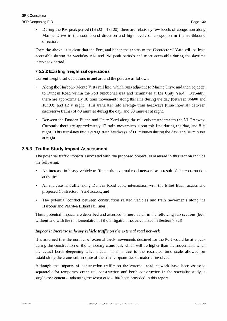
SRK Consulting
BSD Deepening EIR Page 130
JONS/REUT 367079_Transnet_Draft Berth Deepening EIA for public review February 2007
• During the PM peak period (16h00 – 18h00), there are relatively low levels of congestion along
Marine Drive in the southbound direction and high levels of congestion in the northbound
direction.
From the above, it is clear that the Port, and hence the access to the Contractors’ Yard will be least
accessible during the weekday AM and PM peak periods and more accessible during the daytime
inter-peak period.
7.5.2.2 Existing freight rail operations
Current freight rail operations in and around the port are as follows:
• Along the Harbour/ Monte Vista rail line, which runs adjacent to Marine Drive and then adjacent
to Duncan Road within the Port functional area and terminates at the Unity Yard. Currently,
there are approximately 18 train movements along this line during the day (between 06h00 and
18h00), and 12 at night. This translates into average train headways (time intervals between
successive trains) of 40 minutes during the day, and 60 minutes at night.
• Between the Paarden Eiland and Unity Yard along the rail culvert underneath the N1 Freeway.
Currently there are approximately 12 train movements along this line during the day, and 8 at
night. This translates into average train headways of 60 minutes during the day, and 90 minutes
at night.
7.5.3 Traffic Study Impact Assessment
The potential traffic impacts associated with the proposed project, as assessed in this section include
the following:
• An increase in heavy vehicle traffic on the external road network as a result of the construction
activities;
• An increase in traffic along Duncan Road at its intersection with the Elliot Basin access and
proposed Contractors’ Yard access; and
• The potential conflict between construction related vehicles and train movements along the
Harbour and Paarden Eiland rail lines.
These potential impacts are described and assessed in more detail in the following sub-sections (both
without and with the implementation of the mitigation measures listed in Section 7.5.4)
Impact 1: Increase in heavy vehicle traffic on the external road network
It is assumed that the number of external truck movements destined for the Port would be at a peak
during the construction of the temporary crane rail, which will be higher than the movements when
the actual berth deepening takes place. This is due to the restricted time scale allowed for
establishing the crane rail, in spite of the smaller quantities of material involved.
Although the impacts of construction traffic on the external road network have been assessed
separately for temporary crane rail construction and berth construction in the specialist study, a
single assessment - indicating the worst case - has been provided in this report.
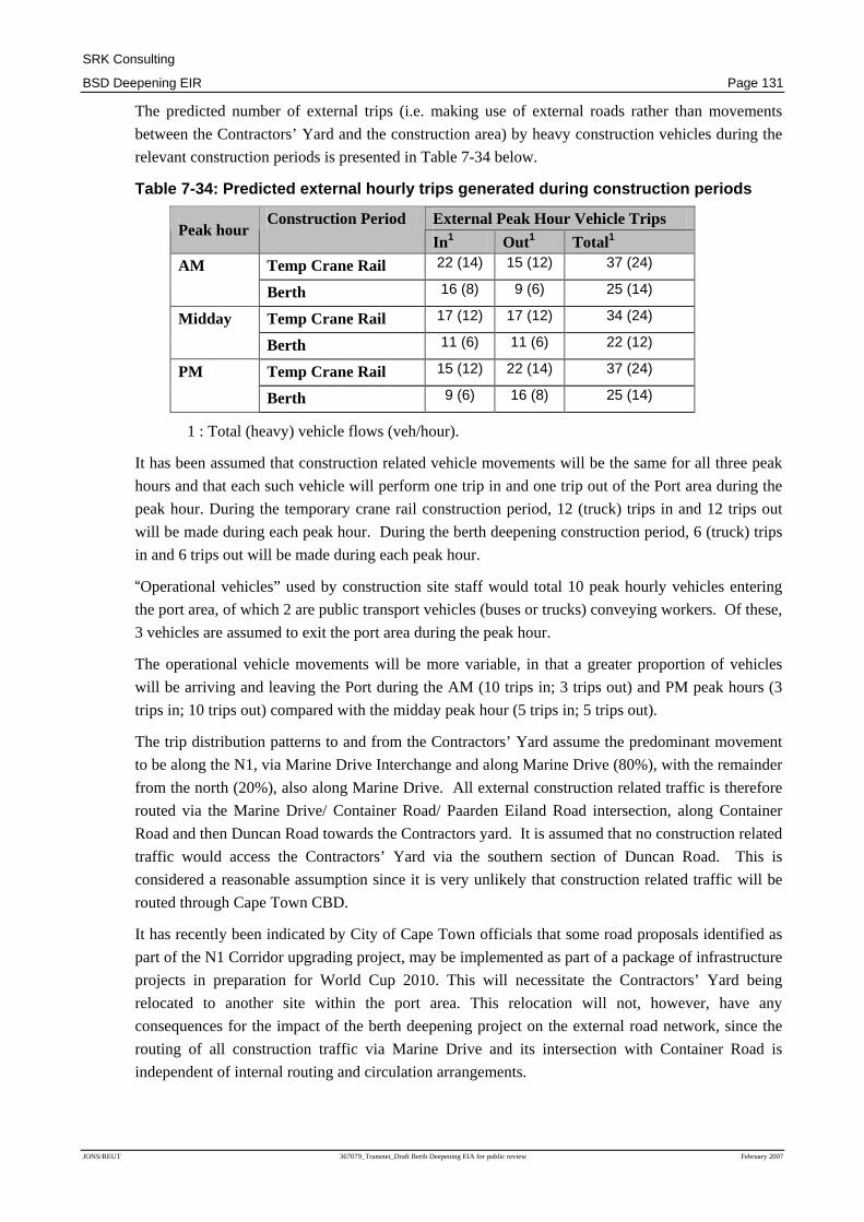
SRK Consulting
BSD Deepening EIR Page 131
JONS/REUT 367079_Transnet_Draft Berth Deepening EIA for public review February 2007
The predicted number of external trips (i.e. making use of external roads rather than movements
between the Contractors’ Yard and the construction area) by heavy construction vehicles during the
relevant construction periods is presented in Table 7-34 below.
Table 7-34: Predicted external hourly trips generat ed during construction periods
External Peak Hour Vehicle Trips Peak hour
Construction Period
In 1 Out1 Total1
Temp Crane Rail 22 (14) 15 (12) 37 (24) AM
Berth 16 (8) 9 (6) 25 (14)
Temp Crane Rail 17 (12) 17 (12) 34 (24) Midday
Berth 11 (6) 11 (6) 22 (12)
Temp Crane Rail 15 (12) 22 (14) 37 (24) PM
Berth 9 (6) 16 (8) 25 (14)
1 : Total (heavy) vehicle flows (veh/hour).
It has been assumed that construction related vehicle movements will be the same for all three peak
hours and that each such vehicle will perform one trip in and one trip out of the Port area during the
peak hour. During the temporary crane rail construction period, 12 (truck) trips in and 12 trips out
will be made during each peak hour. During the berth deepening construction period, 6 (truck) trips
in and 6 trips out will be made during each peak hour.
“Operational vehicles” used by construction site staff would total 10 peak hourly vehicles entering
the port area, of which 2 are public transport vehicles (buses or trucks) conveying workers. Of these,
3 vehicles are assumed to exit the port area during the peak hour.
The operational vehicle movements will be more variable, in that a greater proportion of vehicles
will be arriving and leaving the Port during the AM (10 trips in; 3 trips out) and PM peak hours (3
trips in; 10 trips out) compared with the midday peak hour (5 trips in; 5 trips out).
The trip distribution patterns to and from the Contractors’ Yard assume the predominant movement
to be along the N1, via Marine Drive Interchange and along Marine Drive (80%), with the remainder
from the north (20%), also along Marine Drive. All external construction related traffic is therefore
routed via the Marine Drive/ Container Road/ Paarden Eiland Road intersection, along Container
Road and then Duncan Road towards the Contractors yard. It is assumed that no construction related
traffic would access the Contractors’ Yard via the southern section of Duncan Road. This is
considered a reasonable assumption since it is very unlikely that construction related traffic will be
routed through Cape Town CBD.
It has recently been indicated by City of Cape Town officials that some road proposals identified as
part of the N1 Corridor upgrading project, may be implemented as part of a package of infrastructure
projects in preparation for World Cup 2010. This will necessitate the Contractors’ Yard being
relocated to another site within the port area. This relocation will not, however, have any
consequences for the impact of the berth deepening project on the external road network, since the
routing of all construction traffic via Marine Drive and its intersection with Container Road is
independent of internal routing and circulation arrangements.

SRK Consulting
BSD Deepening EIR Page 132
JONS/REUT 367079_Transnet_Draft Berth Deepening EIA for public review February 2007
The impact of traffic generated by the berth deepening construction project, superimposed on
existing commuter traffic, has been assessed by analysing the performance in terms of LOS of the
following two intersections in the vicinity of the container terminal:
• Marine Drive/Paarden Eiland/Container Road Signalised Intersection; and
• Interchange Ramp from N1 to Marine Drive Unsignalised Intersection
Marine Drive/Paarden Eiland/Container Road Intersection
At present, this intersection operates at reasonable levels of service (LOS C) during both the
weekday AM and PM peak hours, and at a high level of service (LOS B) during the midday peak
hour. However, the analysis does not truly reflect the operation of this intersection during the AM
peak hour due to backup from the city-bound N1 onramp at the Marine Drive interchange. During
the PM peak hour, the effective metering of traffic from the N1 due to congestion on the N1, allows
it to function at the indicated level of service.
For the construction scenario, the performance of the intersection will deteriorate only marginally
during all peak hours considered. The levels of service will not change and the effective impact on
the intersection during both the crane rail and berth deepening construction periods will be
negligible.
Marine Drive/ Northbound Ramp Intersection
At present, the critical northbound through-movement at this intersection operates at a high level of
service (LOS A) during the weekday AM peak hour, at an acceptable level of service (LOS D)
during the midday peak hour, and at a very low level of service (LOS F) during the PM peak hour.
For the construction scenario, the northbound through movement at the intersection will continue to
operate at similar levels of service to the current situation. It should however be noted that delays
experienced under congested conditions increase exponentially as demand increases.
The increased heavy vehicle traffic flows in and out of the Port will thus result in marginally higher
levels of utilization of intersections and routes in the vicinity of the site (notably along Marine
Drive), which are currently unable to absorb traffic growth during peak periods. Port and
metropolitan traffic will experience some increased traffic delay during commuter peak periods.
Although traffic associated with the temporary rail construction is expected to be higher than for the
berth construction, the increase would still be fairly minor and would be for only a short period of
time. In the case of the berth construction, the increase in traffic would occur for a longer period of
time.
The impact of increased traffic on the external road system can be mitigated to a degree by
scheduling the bulk arrivals and departures of trucks conveying construction materials to outside
peak commuter periods, thereby facilitating movement of construction vehicles to and from the Port
area.
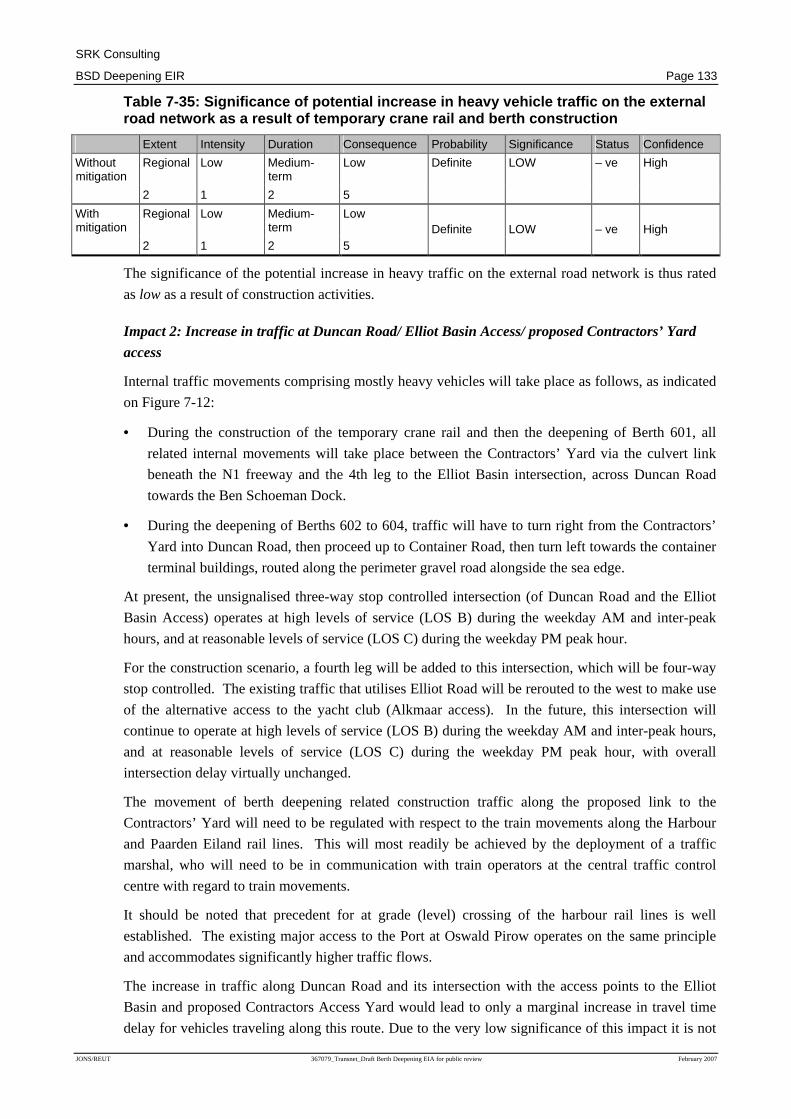
SRK Consulting
BSD Deepening EIR Page 133
JONS/REUT 367079_Transnet_Draft Berth Deepening EIA for public review February 2007
Table 7-35: Significance of potential increase in h eavy vehicle traffic on the external road network as a result of temporary crane rail an d berth construction
Extent Intensity Duration Consequence Probability Significance Status Confidence
Regional Low Medium-term
Low Without mitigation
2 1 2 5
Definite LOW – ve High
Regional Low Medium-term
Low With mitigation
2 1 2 5 Definite LOW – ve High
The significance of the potential increase in heavy traffic on the external road network is thus rated
as low as a result of construction activities.
Impact 2: Increase in traffic at Duncan Road/ Elliot Basin Access/ proposed Contractors’ Yard
access
Internal traffic movements comprising mostly heavy vehicles will take place as follows, as indicated
on Figure 7-12:
• During the construction of the temporary crane rail and then the deepening of Berth 601, all
related internal movements will take place between the Contractors’ Yard via the culvert link
beneath the N1 freeway and the 4th leg to the Elliot Basin intersection, across Duncan Road
towards the Ben Schoeman Dock.
• During the deepening of Berths 602 to 604, traffic will have to turn right from the Contractors’
Yard into Duncan Road, then proceed up to Container Road, then turn left towards the container
terminal buildings, routed along the perimeter gravel road alongside the sea edge.
At present, the unsignalised three-way stop controlled intersection (of Duncan Road and the Elliot
Basin Access) operates at high levels of service (LOS B) during the weekday AM and inter-peak
hours, and at reasonable levels of service (LOS C) during the weekday PM peak hour.
For the construction scenario, a fourth leg will be added to this intersection, which will be four-way
stop controlled. The existing traffic that utilises Elliot Road will be rerouted to the west to make use
of the alternative access to the yacht club (Alkmaar access). In the future, this intersection will
continue to operate at high levels of service (LOS B) during the weekday AM and inter-peak hours,
and at reasonable levels of service (LOS C) during the weekday PM peak hour, with overall
intersection delay virtually unchanged.
The movement of berth deepening related construction traffic along the proposed link to the
Contractors’ Yard will need to be regulated with respect to the train movements along the Harbour
and Paarden Eiland rail lines. This will most readily be achieved by the deployment of a traffic
marshal, who will need to be in communication with train operators at the central traffic control
centre with regard to train movements.
It should be noted that precedent for at grade (level) crossing of the harbour rail lines is well
established. The existing major access to the Port at Oswald Pirow operates on the same principle
and accommodates significantly higher traffic flows.
The increase in traffic along Duncan Road and its intersection with the access points to the Elliot
Basin and proposed Contractors Access Yard would lead to only a marginal increase in travel time
delay for vehicles traveling along this route. Due to the very low significance of this impact it is not

SRK Consulting
BSD Deepening EIR Page 134
JONS/REUT 367079_Transnet_Draft Berth Deepening EIA for public review February 2007
considered necessary to implement mitigation measures and an assessment “with mitigation” has not
been provided in the table below.
Table 7-36: Significance of potential increase in h eavy vehicle traffic on the internal road network
Extent Intensity Duration Consequence Probability Significance Status Confidence
Local Low Medium-term
Very Low Without mitigation
1 1 2 4
Definite VERY LOW – ve High
With mitigation n/a n/a n/a n/a n/a n/a n/a n/a
The significance of the potential increase in heavy traffic on the internal road network is thus rated
as very low.
Impact 3: Potential conflict between construction and train movements
The Contractors’ Yard, situated on the Culemborg site, will be accessed via the culvert beneath the
N1 Freeway. This requires that a temporary gravel road be constructed along the western barrel of
the culvert and pre-cast concrete slabs be placed across the railway lines on exit from the culvert.
This will not impact on freight rail operations significantly, since a rail line is only operational along
the eastern barrel of the rail culvert. Traffic movements crossing rail lines will need to be regulated
to take account of freight train movements. A traffic marshal in communication with train operators
at the central train control centre will ensure this regulation. A four-way stop controlled intersection
is proposed at the intersection of the Contractors’ Yard access road and Duncan Road.
The alignment of the proposed Contractors’ Yard access road across the Harbour and Paarden Eiland
rail lines, creates a potential conflict point between construction-related vehicles and trains. The
nature of the impact is such that a traffic marshal will need to be deployed at this point, who will
need to be in communication with train and signal operators at the central traffic control centre.
It is not considered necessary to introduce additional mitigation measures to address the above
impact, given its very low significance, the deployment of a traffic marshal is considered an essential
mitigation measure, although this would not result in a decrease in the impact rating.
Table 7-37: Significance of potential conflict betw een construction traffic and train movements
Extent Intensity Duration Consequence Probability Significance Status Confidence
Local Low Medium-term
Very Low Without mitigation
1 1 2 4
Definite VERY LOW – ve High
n/a n/a n/a n/a With mitigation
n/a n/a n/a n/a
The significance of the potential conflict between construction traffic and train movements is thus
rated as very low.
SRK Consulting
BSD Deepening EIR Page 135
JONS/REUT 367079_Transnet_Draft Berth Deepening EIA for public review February 2007
7.5.4 Recommended Mitigation Measures: Potential Tr affic Impacts
Essential mitigation measures include:
1. Schedule the bulk of arrivals and departures of truck conveying construction material during the
commuter inter-peak periods (between 09h00 and 16h00 and 18h00 – 06h30);
2. Implement a stop control at the Contractors’ Yard access road approach to Duncan Road; and
3. Deploy a traffic marshal at the crossing of the access road from the Contractors yard with the
Harbour and Paarden Eiland rail lines. The traffic marshal is to maintain communication with
the train and signal operators at the central traffic control centre.
7.6 Potential Visual Impacts
7.6.1 Visual Study Introduction, Terms of Reference and Methodology
This section is based on the Visual Baseline and Impact Assessment, undertaken by SRK
Consulting, which is attached as Appendix F.
The specialist visual assessment seeks to give insight into the visual character and quality of the
area, its visual absorption capacity and the potential significance of the visual impacts created by the
proposed project in order to evaluate these impacts from a visual perspective.
The Terms of Reference for the visual specialist study were as follows:
• Provide an overview of existing visual conditions in the affected environment;
• Identify potentially affected parties and viewpoints;
• Identify the sources of the visual impacts, (including dredging activities);
• Where required, identify the need for mitigation and suggest methods to achieve this; and
• Conform to any relevant guidelines for specialist studies issued by the DEA&DP.
The magnitude or intensity of the visual impacts for the activities at the port and the alternative
dredge disposal sites was determined through analysis and synthesis of the following factors:
• Visibility and viewing distance;
• Visual absorption capacity;
• Landscape / townscape integrity; and
• Sensitivity of viewers.
Assessment of the visual impacts associated with the dredging activities has also been informed by
the Integrated Marine Impact Assessment undertaken by the CSIR, which included modelling of the
distribution of sediments/plumes in the ocean.
7.6.2 Visual Study Baseline Information
The Port of Cape Town has a unique sense of place or strongly defined visual character. This is
created by the activities of the working harbour, with the associated visual elements such as the
stacks of containers, gantry cranes and shipping vessels. This is complemented by the backdrop of
the surrounding visually appealing mountains and sea. Overall the sense of place is one of a working

SRK Consulting
BSD Deepening EIR Page 136
JONS/REUT 367079_Transnet_Draft Berth Deepening EIA for public review February 2007
harbour in a visually appealing context, which creates a visual character that is industrial but
congruent with its surrounds.
The Visual Absorption Capacity (VAC) is the potential of an area to conceal a proposed
development, or absorb visual impacts. The VAC of the BSD is considered to be high due to the
existing highly urbanised (industrial) nature of the site and the screening provided by the buildings
and structures in the harbour and surrounds (particularly the CBD).
Additionally, the background conditions of the sea in the bay absorb much of the visual impact
generated by the sediment plumes. Sediments entering the sea from river estuaries naturally result in
visible plumes, and there is naturally occurring suspended sediment concentration in the surf-zone.
These factors, together with reflected light and the colour of the sea, contribute to the VAC of the
sea
Cape Town has a number of points that offer scenic views of the city and surrounding areas,
including the Port of Cape Town, several multi-storey hotels located within the Cape Town CBD
and in close vicinity to the V&A Waterfront, elevated natural features including Table Mountain and
Signal Hill, which are popular tourist attractions, transport routes on the slopes of Table Mountain
(e.g. N2 and De Waal Drive) as well as residential areas and recreational areas along the eastern
shoreline of Table Bay. There is generally a very low-to-low visibility from the affected viewpoints
due to typically low angles from view points relative to sea level or long distances to the affected
area.
7.6.3 Visual Study Impact Assessment
Potential visual impacts associated with the proposed deepening of the Ben Schoeman Dock and
upgrade to the berths include impacts as a result of:
• Dredging and disposal and associated sediment plumes;
• Berth deck construction activities; and
• New crane installations.
Potential visual impacts are described and assessed in more detail in the following sub-sections, both
without and with the implementation of the mitigation measures listed in Section 7.6.4.
Impact 1: Visual impacts of dredging and disposal and associated sediment plumes
The visual impact of the sediment plumes is caused by suspension of fine sediment in surface water
during dredging and the disposal of dredge spoil. The visibility of the suspended sediment, in the
form of a plume, depends on a number of factors such as the:
• Colour of the suspended sediment;
• Concentration of the suspended sediment;
• Background concentration of sediment in the water, which may vary seasonally;
• The state of the sea;
• Angle of the sun (light conditions); and
• Elevation of the viewer.

SRK Consulting
BSD Deepening EIR Page 137
JONS/REUT 367079_Transnet_Draft Berth Deepening EIA for public review February 2007
Currently, natural sediment plumes are regularly experienced in Table Bay. These plumes result
from the river inflows from the Salt and Diep Rivers and from sediment entrained in the surfzone.
They vary in colour and the darker sediments entering the Bay from the Salt River closer to the Port
are significantly less visible than the lighter sediments entering the Bay from the Diep River further
north.
It is anticipated that the sediments dredged from the BSD will be dark-coloured mud. The plumes
resulting during dredging and disposal of dredge spoil will therefore consist of dark sediment against
the background of the darker blue water.
Sediment plumes become visible at suspended sediment concentrations of between 9 and 13 mg/l,
with a significantly more visible plume occurring at a concentration of 23 mg/l. Based on
background conditions for Table Bay it is assumed that sediment concentrations are likely to become
visible at about 10 mg/l. (CSIR, 2006a)
The plumes in the BSD will be temporary, generated only during dredging activities. Sediment
plumes as a result of dredged material being flushed out of the port and accumulating in the quieter
regions of the bay are only likely to be visible for a total of 2 to 5 days out of a 90 day period and are
likely to occur close to the shore (near Mouille Point). The dark plumes in the BSD will have low
visibility against the dark blue background of the water.
Plumes created at the disposal sites will only occur when dredged material is dumped. The plumes
will only be visible for a short duration and are expected to be visible for a cumulative total of 2 to 5
days in a 90 day period. Various scenarios for disposal are being considered (based on various
dredge options available) and the scenarios with a greater number of dumps per day will therefore
have a marginally greater visual impact.
The impact, although negligible, is greatest for the “combination cutter suction dredger and backhoe
dredger” operation due to the greater number of hopper barge dumps assumed per day for these
scenarios. The creation of sediment plumes is predicted to be greatest in winter, however the spatial
extent of plumes in winter is likely to be masked by the generally higher turbidity expected during
this season.
The plumes are only likely to be visible from certain elevated positions such as Table Mountain,
Signal Hill and certain view points from the N2 and De Waal Drive. Even then, the visibility of the
plumes is expected to be limited by the following factors:
• The relatively low angle of the viewer relative to the water surface from most of these view
points (the closer the viewer is to sea level the less visible the plume will be);
• The relatively short period of time most viewers are expected to spend at any given viewpoint;
• The relatively short period of time the plumes are expected to be visible;
• The distance of most view points from the affected areas (2.5 km +); and
• The occasional natural occurrence of sediment plumes along the Table Bay coastline, indicating
that the dredging plume would not be a highly unusual phenomenon for the area.
As such, the significance of the visual impact of the dredging and dumping activities is considered to
be very low and no essential mitigation of this impact is required. Assessment of this impact “with
mitigation” is thus not provided in the table below.

SRK Consulting
BSD Deepening EIR Page 138
JONS/REUT 367079_Transnet_Draft Berth Deepening EIA for public review February 2007
Table 7-38: Significance of the potential visual im pact of dredge plume
Extent Intensity Duration Consequence Probability Significance Status Confidence
Local Low Short term Very Low Without mitigation 1 1 1 3
Probable Very Low -ve Medium- High
With mitigation n/a n/a n/a n/a n/a n/a n/a n/a
The significance of the potential visual impacts of sediment plumes resulting from dredging and the
disposal of dredge spoil is thus rated as very low.
Impact 2: Visual impacts of berth deck construction activities
The extension of the berth deck involves the dredging of a scour protection trench, the driving of
piles into the sea bed to support the deck extension and the construction of a concrete deck
extension, casting the concrete in situ or using pre-cast concrete. Visual impacts at the BSD will be
mainly related to these construction activities, as well as machinery and material moving on the site.
In addition, storage of construction materials, concrete batching and welding activities are proposed
to take place on the 1.8 ha Contractors’ Yard south of the BSD. This site is surrounded by industrial
infrastructure of the BSD and the Woodstock industrial area and not easily accessible or visible to
the public.
The impact on the visibility of the construction areas is expected to be limited by:
• The current visual context and industrial nature of the area, which will visually absorb additional
construction machinery and activities at the BSD and the Contractors’ Yard;
• The fact that vessels of different sizes are already using the BSD, so that additional dredging-
related vessels would not be highly noticeable;
• The relatively short period of time most viewers are expected to spend at any given viewpoint;
• The distance of most tourist view points from the BSD (2.5 km +); and
• The temporary nature of the construction activities.
Some mitigation measures to reduce the negative visual impacts of construction are suggested in
Section 7.6.4. However these are not expected to significantly reduce the visual impact and the very
low rating therefore remains the same.
Table 7-39: Significance of the potential visual im pact of construction activities
Extent Intensity Duration Consequence Probability Significance Status Confidence
Local Low Short term Very Low Without mitigation 1 1 1 3
Probable Very Low -ve High
Local Low Short term Very Low With mitigation 1 1 1 3
Probable Very Low -ve High
The significance of the potential visual impact of the berth construction activities, assuming the
implementation of mitigation measures, is thus rated as very low.

SRK Consulting
BSD Deepening EIR Page 139
JONS/REUT 367079_Transnet_Draft Berth Deepening EIA for public review February 2007
Impact 3: Visual impact of new crane installations
The BSD currently accommodates four Demag and two Noell ship to shore cranes, which are located
on rails running parallel to the edge of berths 601 – 604. The cranes are mobile and can be moved on
the rails along the berths as required to load and load containers onto and from vessels moored along
the berths.
Initially, the four Demag cranes will be replaced by six new cranes, resulting in a total of eight
working cranes. The intention is to eventually replace these existing cranes with up to a total of 12
new cranes , dependent on demand. The approximate dimensions of the existing and proposed cranes
are indicated in Table 7-39.
Table 7-40: Approximate dimensions of cranes
Crane Approximate Height (with jib in upright position)
Approximate Length
Demag 75 m 90 m
Noell 92 m 105 m
Proposed new cranes 99 m 105 m
Source: Transnet
The main visual impact from the new cranes would thus result from their greater height (7 m higher
than Noell cranes and 24 m higher than Demag cranes) and potentially from the increased number of
cranes. They are therefore likely to have increased visibility from a number of viewpoints, including
certain points along De Waal Drive and the N2, from Table Mountain and some of the surrounding
hotels.
The visual impact of the newly installed cranes is however expected to be limited due to:
• The existing industrial nature of the site, which includes crane installations both at the BSD and
Duncan Dock, which is located much closer to viewers, so that the installation of new cranes -
even though higher - at the BSD will not significantly alter the existing visual environment;
• The distance of most tourist view points from the BSD (2.5 km +); and
• The relatively short period of time most viewers are expected to spend at any given viewpoint.
Some mitigation measures to reduce the negative impacts of the new crane installations are
suggested in Section 7.6.4. However these are not expected to significantly reduce the visual impact
and the rating therefore remains the same.
Table 7-41: Significance of the potential visual im pact from new cranes
Extent Intensity Duration Consequence Probability Significance Status Confidence
Local Low Long term Low Without mitigation 1 1 3 5
Probable Low -ve High
Local Low Long term Low With mitigation 1 1 3 5
Probable Low -ve High
The significance of the potential visual impact of the new cranes, assuming the implementation of
mitigation measures, is thus rated as low.

SRK Consulting
BSD Deepening EIR Page 140
JONS/REUT 367079_Transnet_Draft Berth Deepening EIA for public review February 2007
7.6.4 Recommended Mitigation Measures: Potential Vi sual Impacts
No Essential mitigation measures are required to reduce the visual impacts associated with the
project.
Optional mitigation measures include:
1. Consider the visual impacts of sediment plumes in selection of the most suitable dredge method.
2. Limit the area used for construction activities including the associated storage of waste,
materials and equipment;
3. Ensure that rubble and waste material are removed regularly from the site;
4. Store construction equipment and material in an orderly manner on a designated site;
5. Unless considered a safety risk, paint cranes a colour that will be least visible against the skyline
(grey/blue); and
6. Monitor and react to complaints about plumes generated by project activities. .
7.7 Potential Maritime Archaeological Impacts
7.7.1 Maritime Archaeology Study Introduction, Term s of Reference and Methodology
This section is based on the Maritime Archaeology Baseline and Impact Assessment, undertaken by
Bruno Werz, which is attached as Appendix G. The purpose of the study was to identify the
underwater heritage resources that may be present in the study area, and to assess the impact of the
proposed project on these resources.
The Terms of Reference for the assessment were as follows:
• Review existing studies at the Port of Cape Town, e.g. the Strategic Environmental Assessment
of the Port of Cape Town and the Container Terminal Expansion, to identify maritime
archaeological features in the vicinity of the proposed activities;
• Review legal requirements in terms of heritage legislation relevant to this EIA;
• Identify potential maritime archaeological issues related to the proposed project;
• Consult with the South African Heritage Resources Agency (SAHRA) to confirm the approach
and findings of the review as well as compliance with relevant heritage legislation;
• Where required, identify the need for mitigation and suggest methods to achieve this;
• Devise a practical monitoring programme that will, firstly, allow real time control of project
activities to reduce environmental risks and, secondly, facilitate a qualitative determination of
actual versus predicted project impacts; and
• Conform to any relevant guidelines for specialist studies issued by the DEA&DP.
Determination of the potential existence of material of archeological, cultural or historical value
within the areas to be affected by the project included a desk top analysis of relevant literature,
databases and archival documents; the interpretation of cartographic material; as well as interviews
with oceanographers, geologists and archaeologists from the University of Cape Town and the South

SRK Consulting
BSD Deepening EIR Page 141
JONS/REUT 367079_Transnet_Draft Berth Deepening EIA for public review February 2007
African Museum regarding wind and current patterns in the bay, beach morphology, prehistoric
material onshore and historical sites within the harbour area.
7.7.2 Maritime Archaeology Study Baseline Informati on
Details of the maritime archaeological material previously encountered in Table Bay has been
described in detail in Section 5.2.4.
Available information does not allow for the accurate prediction of the exact location, nature, current
state and extent of the underwater cultural resource that may be encountered during the proposed
works, and the assessment undertaken and proposed mitigation measures have been based on the
potential for material to be uncovered, based on what is known to exist in the broader region.
Due to previous dredging operations in the Ben Schoeman Dock, it is likely that much of the
material that may have occurred in this area has been disturbed and removed. The possibility
(although small) however exists that some such material may still exist in some areas.
7.7.3 Maritime Archaeology Study Impact Assessment
In the case of material of archaeological value existing in the Ben Schoeman Dock, the potential
impact of the proposed project would be the disturbance of such archaeological sites and the
resulting damage to and dispersal of cultural material, mainly as a result of blasting and dredging
activities.
The potential impact is described and assessed in more detail in the following table, both without
and with the implementation of the mitigation measures listed in Section 7.7.4
Impact 1: Impact on Marine Archaeology
The proposed deepening of the Ben Schoeman Dock includes dredging of a layer of material
approximately 4.8m thick from the area of Berth 600, 2.7m near Berth 601 and 1.5m from the
western section (berths 602-604).
An estimated volume of 86,956m³ of hard rock is present in the area, which will require blasting
making use of multiple small charges. Although blasting may damage archaeological material should
it occur in the area, the impact will be less than in the case of indiscriminate blasting.
Various dredging options are being considered, although the nature of the dredge equipment that will
be used cannot yet be finalised and the assessment of the impacts of dredging on archaeological
material that may occur in the area has thus assumed a worst case scenario.
From an archaeological point of view, a dredger with relatively limited capacity would reduce the
damage that may be caused, especially to larger items, such as parts of a shipwreck’s hull. A dredge
operation which would allow dredged material to be expelled onto an exposed surface, would allow
for the option of visually monitoring at least part of the removed deposits. This visual control,
combined with the option to temporarily stop dredging activities to recover cultural material,
represents the most important mitigating factors from an archaeological perspective for this specific
project.
The use of a TSHD does not seem to offer such opportunity. In the case of the use of a backhoe
dredger, this will facilitate temporarily movement to another area should archaeological material be

SRK Consulting
BSD Deepening EIR Page 142
JONS/REUT 367079_Transnet_Draft Berth Deepening EIA for public review February 2007
found. In this way, dredging can continue while there is an option to survey specific areas elsewhere
for more archaeological material.
In terms of the disposal of dredged material, the use of the shallower of the two potential sites (Site 2)
would be considered more favourable than the deeper site (Site 1) from an archaeological perspective
(not marine ecology perspective). This would allow a limited chance that objects or materials of
archaeological value to still be recovered following disposal. This would be seriously hampered in the
case of disposal at Site 1, due to the need for specialized diving equipment in order to recover such
materials.
The potential impact on marine cultural resources is considered to be of high intensity, due to the
uncertainty of the existence of material that may exist in the basin (and thus application of the
precautionary principle). In the case of such material being present, disturbance as a result of blasting
and dredging activities is inevitable. As this material will be permanently lost if suitable measures are
not taken to recover and record the position and existence of the find, the rating of this impact without
mitigation is considered medium.
The extent of the impact which could occur relates specifically to the physical remains of the
underwater cultural heritage that may be present in the basin. The extent is thus considered local,
although this does not take into consideration the non-tangible values that can be attributed to this
heritage. If, for example, parts of a 19th century British shipwreck are uncovered, its attributed value
to the history and culture of South Africa and Britain is not taken into consideration, but merely the
fact that it is located in the BSB.
Making allowance for intervention and monitoring by a suitably qualified maritime archaeologist
during dredging activities would allow for the significance of this impact to be reduced, as any
material which may be encountered could be recorded and recovered where considered necessary.
Table 7-42: Significance of potential impact on mar ine archaeology
Extent Intensity Duration Consequence Probability Significance Status Confidence
Local High Long-term High Without mitigation 1 3 3 7
Possible MEDIUM – ve High??
Local Low Long-term Low With mitigation 1 1 3 5
Possible LOW – ve High
The significance of the potential impact on archaeological material that may be present in the Ben
Schoeman Dock, assuming the implementation of mitigation measures, is thus rated as low.
Note: Although the specialist has rated the probability of this impact occurring (without mitigation)
as probable, resulting in a high significance rating, based on the opinion of the EIA consultant, with
more holistic view of the overall impacts, this probability rating has been reduced to possible,
resulting in a medium significance (without mitigation). This is based on the fact that the area to be
dredged has been extensively dredged in the past, and much of the cultural resource which may have
occurred is likely to have been disturbed in the past.

SRK Consulting
BSD Deepening EIR Page 143
JONS/REUT 367079_Transnet_Draft Berth Deepening EIA for public review February 2007
7.7.4 Mitigation measures: Maritime Archaeological Impact
Essential mitigation measures include:
1. Where applicable, take the recommendations of the Maritime Archaeologist into account when
planning and conducting blasting and dredge operations to minimize impacts on the potential
cultural resource;
2. Inform both NPA and SAHRA of the exact location and extent of the dredge disposal site;
3. Ensure that all contractors and subcontractors are made aware of the potential existence of
underwater heritage resources, and instructed on the correct procedure for preserving the
integrity thereof. Also instruct sub-contractors to monitor dredging activities (through visual
inspection of at least part of the dredge material brought to the surface before being deposited at
the disposal site, where possible) for any cultural material that may be uncovered. In the case of
material being uncovered, a qualified archaeologist is to be notified immediately and the
material secured and kept for inspection;
4. Ensure that monitoring is particularly vigilant during dredging of the area from Berth 603
westwards;
5. Formally inform SAHRA in writing of the planned development;
6. Retain a suitably qualified archaeologist as a consultant for the duration of the dredging
operations to provide advice to the Contractor as and when required. This person may have to:
liaise with SAHRA and the client / dredger operators; pay ad hoc site visits to monitor blasting
and dredging activities; secure the necessary licences and permits from the Controller of
Customs and Excise and the SAHRA; and render assistance should any cultural material be
dredged up;
7. Provide assistance should the maritime archaeologist deem it necessary to undertake an
underwater survey and/or remove material. This may include support from NPA divers and
others;
8. Make provisions for essential mitigating activities related to underwater cultural material that
may be recovered. This would include:
− making funds available for monitoring activities to be undertaken by the project’s maritime
archaeologist if required;
− funding for potential limited underwater fieldwork if required;
− funding for the basic preservation and documentation of dredged up material if required; and
− allocation of a suitable area where recovered material may be temporarily stored and treated
if required; and
9. Allow for any valuable material recovered during dredging to be adequately stored and
preserved. Excavation and recovery can only be done after a licence from the Department of
Customs and Excise has been issued and a permit from the SAHRA has been obtained.

SRK Consulting
BSD Deepening EIR Page 144
JONS/REUT 367079_Transnet_Draft Berth Deepening EIA for public review February 2007
Optional mitigation measures are:
1. Where practicable and cost effective, preferably make use of a backhoe dredger, which allows
for visual monitoring of the dredge spoil before it is removed. This is especially the case in the
archaeologically sensitive area from berth 603 towards the entrance channel; and
2. Preferably dispose of dredge spoil in an area that will allow future recovery of heritage
resources. It should be noted that either of the proposed dredge disposal sites would allow for
this, although the associated costs would be higher for a deeper site.