Embed Size (px)
Citation preview

1 Third International Symposium 2016 l Partnership for Technology in Peacekeeping
7-11 November 2016 l Seoul City Hall, Seoul, Korea
Third InternationalSymposium
2016
Partnership for Technology in PeacekeepingInformation and Communications Technology DivisionUnited Nations Department of Field Support

2 Third International Symposium 2016 l Partnership for Technology in Peacekeeping
3 Third International Symposium 2016 l Partnership for Technology in Peacekeeping
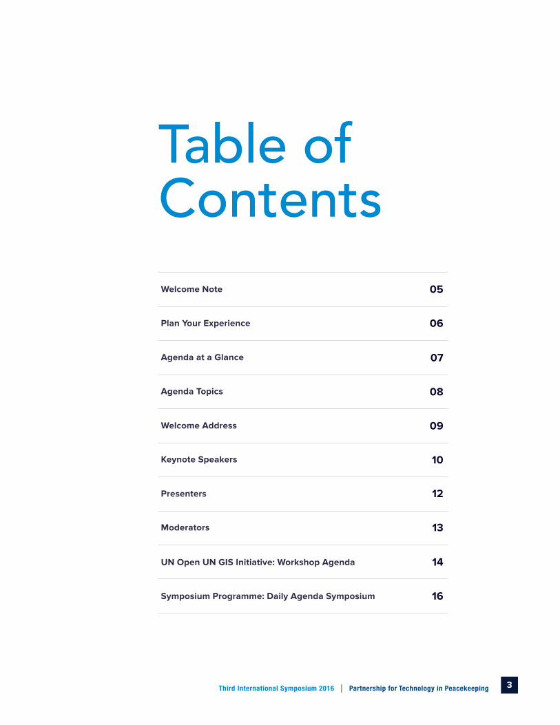
Welcome Note 05
Plan Your Experience 06
Agenda at a Glance
Agenda Topics
Welcome Address
Keynote Speakers
Presenters
Moderators
Symposium Programme: Daily Agenda Symposium
UN Open UN GIS Initiative: Workshop Agenda
Table of Contents
07
08
09
10
12
13
14
16

4 Third International Symposium 2016 l Partnership for Technology in PeacekeepingSeoul City Hall, Seoul, South Korea
5 Third International Symposium 2016 l Partnership for Technology in Peacekeeping
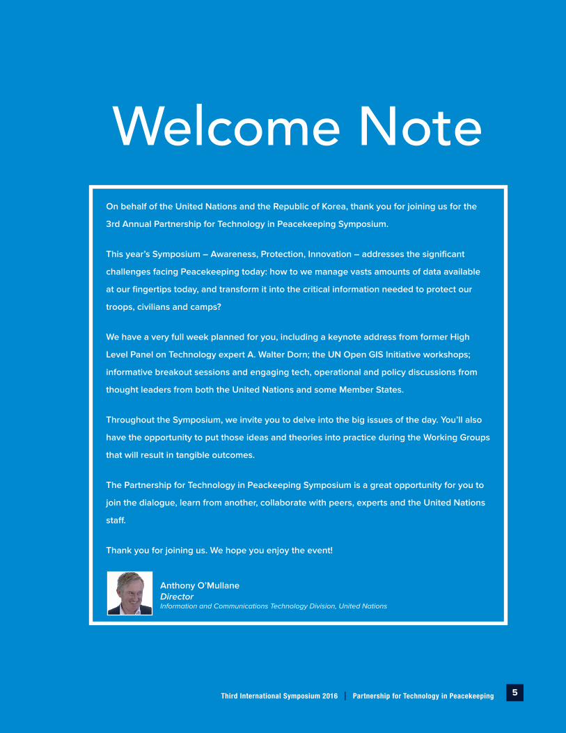
On behalf of the United Nations and the Republic of Korea, thank you for joining us for the
3rd Annual Partnership for Technology in Peacekeeping Symposium.
This year’s Symposium – Awareness, Protection, Innovation – addresses the significant
challenges facing Peacekeeping today: how to we manage vasts amounts of data available
at our fingertips today, and transform it into the critical information needed to protect our
troops, civilians and camps?
We have a very full week planned for you, including a keynote address from former High
Level Panel on Technology expert A. Walter Dorn; the UN Open GIS Initiative workshops;
informative breakout sessions and engaging tech, operational and policy discussions from
thought leaders from both the United Nations and some Member States.
Throughout the Symposium, we invite you to delve into the big issues of the day. You’ll also
have the opportunity to put those ideas and theories into practice during the Working Groups
that will result in tangible outcomes.
The Partnership for Technology in Peackeeping Symposium is a great opportunity for you to
join the dialogue, learn from another, collaborate with peers, experts and the United Nations
staff.
Thank you for joining us. We hope you enjoy the event!
Anthony O’Mullane Director Information and Communications Technology Division, United Nations
Welcome Note

6 Third International Symposium 2016 l Partnership for Technology in Peacekeeping
We have three in-depth Topics and the United Nations Open GIS Initiative that will provide you with the opportunity to dive in. We’ve divided each topic into four Break-out Sessions that cover important areas that you, as technical professionals, will focus on.
Some sections of this agenda focus on the nontechnical aspects of peacekeeping technology such as training, coaching, guidance, leadership development, planning, testing and evaluating. We welcome new ideas that challenge conventional thinking, represent new approaches, and reflect emerging trends and emerging technology. We invite you to participate fully.
Build Your Agenda Based on Your Specific Needs and Areas of Interest
l Focus on the strategic insight that supports the development or implementation of an actionable plan.
Interact with Colleagues from Other Member States and UN Staff
l Moderated discussions are for exchanging ideas and best practices with your peers with a focus on the reality and challenges in peacekeeping today.
l Breakout-Sessions and Power Networking/Coffee breaks offer small scale and interactive opportunities to drill down on specific topics.
Sponsor or Engage in a Project and/or Initiative
l Walk away with actionable ideas for the topics, projects and initiatives that you are most interested in.
Focused Content. New Ways of Thinking.
Plan Your Experience
7 Third International Symposium 2016 l Partnership for Technology in Peacekeeping
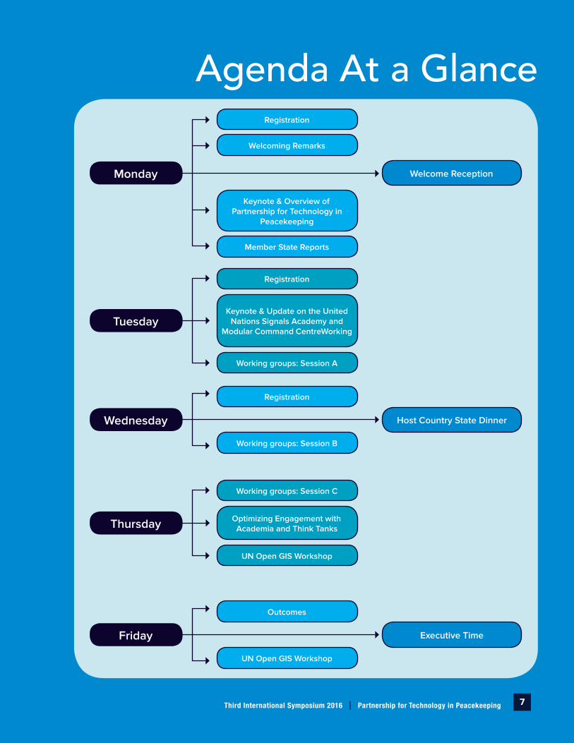
Agenda At a GlanceRegistration
Welcoming Remarks
Keynote & Overview of Partnership for Technology in
Peacekeeping
Member State Reports
Monday Welcome Reception
Tuesday
Registration
Keynote & Update on the United Nations Signals Academy and
Modular Command CentreWorking
Working groups: Session A
Wednesday Host Country State Dinner
Registration
Working groups: Session B
Thursday
Working groups: Session C
Optimizing Engagement with Academia and Think Tanks
UN Open GIS Workshop
Friday Executive Time
Outcomes
UN Open GIS Workshop

8 Third International Symposium 2016 l Partnership for Technology in Peacekeeping
Agenda TopicsGeospatial Information Services and Situational Awareness
Enabling Geospatial Information Services (GIS) with the best available data for modelling and simulation, while setting a framework to control its dissemination to improve situational awareness and understanding of the operational environment, will provide peacekeeping with greater analysis at the service of decision making.
Protection Technologies: Sensors, Security and Reconnaissance
Increasingly, highly sensitive information needs to be collected, classified, correlated and shared in UN peace operations. Policies, procedures and platforms must be developed that protect and manage such information.
Innovation in Information and Communication Technologies
Applying innovative thinking to your challenges as a leader is one step in creating an innovative, organizational response to change and challenge. But developing a culture of innovation, where others throughout the organization apply innovative thinking to solve problems and develop new products and services, requires additional training. When direction, alignment, and commitment are created around innovation, organizations emerge as more productive and more innovative.
Optimizing Engagement with Academic and Research Institutions
Combining existing research and development with academic and UN Peacekeeping expertise to forge a strong partnership is the way to advance next generation technological innovations that serve peacekeeping and sustainable development.
United Nations Open GIS Initiative
ComItaturia ndandelit officae perfers perroriberum dolores a qui cus dunt et eum fuga. Ciame veliqui as eos earunt etur aut aut expe nestibusa quasperit officaesedi illuptam ut quia porem imincte mporios dellacea si dolorenimus volendiam aperspe rferia nos neceariate. Ces adit eos sit et aut aut ame nimil id quat ea peror abore pa velliam, eos rentioreped mos es dolut re sus adipsa cusdant.
9 Third International Symposium 2016 l Partnership for Technology in Peacekeeping
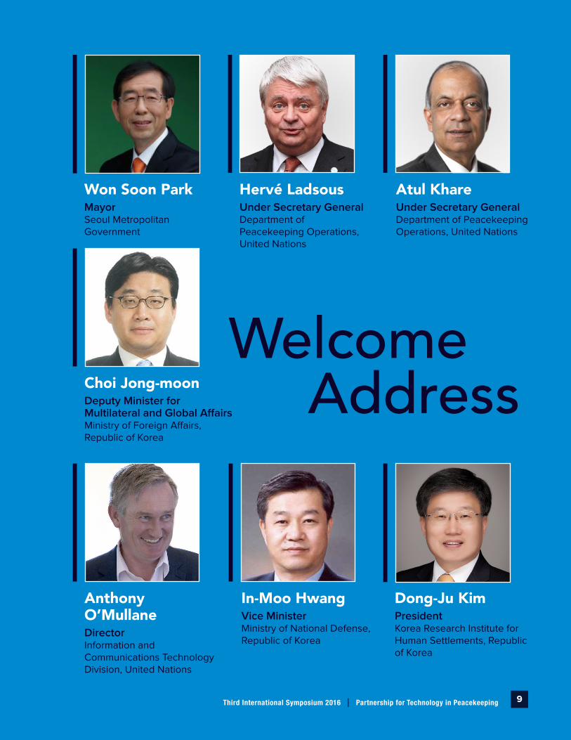
Welcome Address
Won Soon ParkMayorSeoul Metropolitan Government
Atul KhareUnder Secretary GeneralDepartment of Peacekeeping Operations, United Nations
Hervé LadsousUnder Secretary GeneralDepartment of Peacekeeping Operations, United Nations
In-Moo HwangVice MinisterMinistry of National Defense, Republic of Korea
Anthony O’MullaneDirectorInformation and Communications Technology Division, United Nations
Dong-Ju KimPresidentKorea Research Institute for Human Settlements, Republic of Korea
Choi Jong-moonDeputy Minister for Multilateral and Global AffairsMinistry of Foreign Affairs, Republic of Korea

10 Third International Symposium 2016 l Partnership for Technology in Peacekeeping
Walter Dorn PhD.Professor of Defense StudiesRoyal Military College of Canada and the Canadian Armed Forces College, Givernment of Canada
Ki-Joune LiProfessor, OpenGDS and Co-Chair UN Open GIS Initiative
Raey-Ho ParkDirector GeneralInformation Planning, Office of Planning and Coordination, Ministry of National Defense, Republic of Korea
Walter Dorn is Professor of Defence Studies at the Royal Military College of Canada (RMC) and the Canadian Forces College (CFC). He holds a Ph.D. in Chemistry from the Univ. of Toronto. He addressed parliamentary bodies on several continents and drafted a parliamentary declaration on the ratification and implementation of the treaty that was signed by over a thousand parliamentarians. A former member of the United Nations Expert Panel on Technology and Innovation in UN Peacekeeping, Dr. Dorn has written several books, including Keeping Watch: Monitoring, Technology, and Innovation in UN Peace Operations, and most recently edited the volume, Air Power in UN Operations: Wings for Peace.
Mr. Raey-Ho Park is the Director General for Information Planning in the Office of Planning and Coordination in the Ministry of National Defense. Within the Ministry, he has served as Commander, Defense Command and Communication Command and Chief of the Information Communication Division, Republic of Korea headquarters.
Ki-Joune Li is a professor of Computer Science and Engineering at Pusan National University, South Korea. He received his Bachelor and Master of Science degrees in computer sciences from Seoul National University, in 1984 and 1986, and PhD in spatial databases from INSA de Lyon, France in 1992. Since then, he has been working on GIS and spatial databases and 2007 launched an ambitious multi-national project called ISA (Indoor Spatial Awareness) for indoor spatial information modeling. Since 2016, he has been leading the UN Open GIS initiative as a co-chair, which aims at developing and providing open source geospatial software to the UN. He is a directive board member of SSTD Endowment.
Keynote SpeakersKeynote Speakers

11 Third International Symposium 2016 l Partnership for Technology in Peacekeeping
Keynote Speakers Keynote Speakers
Kyoung-Soo EomChief UNGIS and Co-Chair UN Open GIS Initiative
Juan A. Hurtado Science and Technology AdvisorUS Southern Command and Co-Chair UN Open GIS Initiative
HaeKyong Kang PhD.Research FellowKorea Reasearch Institute for Human Settlements, Republic of Korea
Mr. Kyoung-Soo Eom has been serving as Chief of the Geospatial Information Section (formerly UN Cartographic Section) since 2005 in the United Nations. He has over 30 years of technical and management experience in the public and private sectors as well as military service.
Prior to his work with the United Nations, Mr. Eom worked for LG-CNS (formerly LG-EDS Systems, a System Integration Company) in Seoul, Korea as General Manager and Project Manager. He also served in the Korean Army as the Chief of Combined Terrain Analysis Team of Korea-USA Combined Force Command in Seoul.
Mr. Hurtado is the Science and Technology Advisor, Headquarters United States Southern Command, Miami, Florida. He serves as the principal advisor in scientific and technical matters to support security and stability in a geographical area comprised of 32 countries from Central and South America, and the Caribbean. He leads efforts for the formulation of materiel solutions to operational needs, demonstrations of technology in operational scenarios, coordination for rapid system development, and the integration of mature technical capability into field activities
In addition, Mr. Hurtado leads the Science, Technology and Experimentation Division, Theater Engagement Directorate, composed of science advisors and operational managers to conduct research and development, innovation, joint experimentation and oversees the Counter Improvised Explosive Device activities. Mr. Hurtado became the Science and Technology Advisor in July 2002.
Dr. HaeKyong Kang is Research Fellow for Korea Research Institute for Human Settlements supervised by Prime Minister’s office and funded by the republic of Korean government. She is the program manager of OpenGDS Research and Development Group responsible for developing open source GIS software, supervising 80 researchers from 9 organizations. She is a member of UN OpenGIS Initiative which aims to develop open source GIS solutions for UN missions like peacekeeping operation.
12 Third International Symposium 2016 l Partnership for Technology in Peacekeeping
Pres
ente
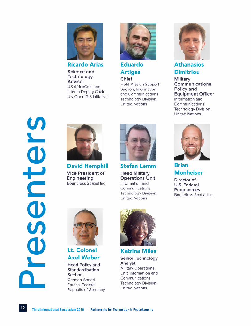
rsEduardo ArtigasChiefField Mission Support Section, Information and Communications Technology Division, United Nations
Ricardo AriasScience and Technology AdvisorUS AfricaCom and Interim Deputy Chair, UN Open GIS Initiative
Athanasios DimitriouMilitary Communications Policy and Equipment OfficerInformation and Communications Technology Division, United Nations
Lt. Colonel Axel WeberHead Policy and Standardisation SectionGerman Armed Forces, Federal Republic of Germany
Stefan LemmHead Military Operations UnitInformation and Communications Technology Division, United Nations
Katrina MilesSenior Technology AnalystMilitary Operations Unit, Information and Communications Technology Division, United Nations
Brian MonheiserDirector of U.S. Federal Programmes Boundless Spatial Inc.
David HemphillVice President of EngineeringBoundless Spatial Inc.

13 Third International Symposium 2016 l Partnership for Technology in Peacekeeping
Suzanne ShanahanActing Deputy DirectorInformation and Communications Technology Division, United Nations
Dirk DruetPolitical Affairs Officer (Policy and Planning)Department of Policy Evaluation and Training, United Nations
Gooshik ChoiICT Lead Architectinformation and Communications Technology Division, United Nations
Widmark ValmeChief of Communications and Information TechnologiesMINUSCA, United Nations
Allan CanonizadoChief of Communications and Information TechnologiesMINUSMA, United Nations
Working
Groups
Ricardo AriasScience and Technology Advisor
US AfricaCom and Interim Deputy Chair, UN Open GIS Initiative
Maria A. BrovelliProfessor
OSGeo and Politecnico di Milano and Chair of UN Open GIS Spiral-II Capacity Building
Dimitri Dello Buono PhD.Chief of Information Management
Head of geoSDI Laboratory, Italy
Massimiliano CannataProfessor
OSGeo and Univ. of Applied Sciences & Arts of Southern Switzerland
Younghoon ChoiDirector-General for IT
Seoul Metropolitan Government
Guillaume CrilouxChief Geo Analysis
UN GIS
Diego GonzalezGIS Officer
UNGSC
Juan A. HurtadoScience and Technology Advisor
US Southern Command and Co-Chair, UN Open GIS Initiative
Joon-Seok Kim PhD.Open GDS
Pusan National University, Republic of Korea
Brian MonheiserDirector
US Defense and Intelligence Programmes, Boundless Spatial Inc.
Kais ZouabiChief GIS
UNIFIL, United NationsUN
Ope
n G
IS
Initi
ativ
e
Moderators

14 Third International Symposium 2016 l Partnership for Technology in Peacekeeping
Monday 07.11.201609:00 – 09:30 Arrival of Participants and Registration
09:30 – 10:00
SESSION *OG-1: OPENING AND WELCOMING
Moderator: Mr. Kyoung-Soo Eom, Chief UNGIS and Co-Chair UN Open GIS
Welcome Remarks: Mr. Anthony O’Mullane, Director of Information and Communications Technology Division, United Nations and Dr. Dong-Ju Kim, President, Korea Research Institute for Human Settlements (KRIHS)
10:00 – 10:15 Networking Coffee Break (15 mins)
10:15 - 12:00
SESSION OG-2: UN OPEN GIS VISION AND ROADMAP
Moderator: Mr. Kyoung-Soo Eom, Chief UNGIS and Co-Chair UN Open GIS
Keynote Presentation: Prof. Ki-Joune Li, OpenGDS and Co-Chair UN Open GIS, Mr. Juan A. Hurtado, Science & Technology Advisor, US Southern Command, Co-Chair UN Open GIS and Mr. Ricardo Arias, Science & Technology Advisor, US Africa Command, Interim Deputy Chair UN Open GIS
Panel Discussion: Prof. Maria A. Brovelli, Politecnico di Milano and Chair of UN Open GIS Spiral-II, Dr. Dimitri Dello Buono, Head of geoSDI Laboratory, Italy, Prof. Massimiliano Cannata, OSGeo and Univ. of Applied Sciences & Arts of Southern Switzerland, Mr. Bong-Yeon Cho, Director, Geospatial Information Division, Seoul Metropolitan Government, Ms. Andrea Leong, Senior Policy Officer, Singapore, Mr. David Memphill, Vice President, Boundless, Dr. Seok-Joon Kim, Vice President, KT, Mr. Kais Zouabi, Chief GIS, UNIFIL and Mr. Guillaume Criloux, Chief Geo Analysis, UNGIS
Tuesday 08.11.2016
14:00 - 16:30
SESSION *JO-1: WORKING GROUP - GEOSPATIAL INFORMATION AND SITUATIONAL AWARENESS
Operational requirements and challenges for UN peacekeeping operations, and review and progress update as well as lessons learned for the activities in 2016
Moderator: Ms. Suzanne Shanahan, Deputy Director of ICTD/DFS/UN and Mr. Kyoung-Soo Eom, Chief UNGIS and Co-Chair UN Open GIS
Keynote Presentation: Mr. Guillaume Criloux, Chief Geo Analysis, UNGIS
Panel Discussion: Mr. Juan A. Hurtado, Science & Technology Advisor, US Southern Command, Co-Chair UN Open GIS, Brigadier General, Syed Mazhar Hussain, Ministry of Defense, Pakistan, Prof. Ki-Joune Li, OpenGDS and Co-Chair UN Open GIS, Dr. Dimitri Dello Buono, Head of geoSDI Laboratory, Italy, Prof. Maria A. Brovelli, Politecnico di Milano and Chair of UN Open GIS Spiral-II, Dr. HaeKyong Kang, OpenGDS and UN Open GIS Secretariat, Mr. Ricardo Arias, Science & Technology Advisor, US Africa Command, Interim Deputy Chair UN Open GIS, Mr. Kais Zouabi, Chief GIS, UNIFIL and Mr. Timur Obukhov, GIS Officer, UNGIS
16:00 – 16:30 Networking Coffee Break (30 mins)
16:30 - 18:00[CONTINUE] SESSION *JO-1: WORKING GROUP - GEOSPATIAL INFORMATION AND SITUATIONAL AWARENESS
Operational requirements and challenges for UN peacekeeping operations, and review and progress update as well as lessons learned for the activities in 2016
*OG Session: UN Open GIS Initiative Session, JO Session: Joint Session within the UN Symposium Programme
Jointly Organized with the Third UN Symposium on Partnership for Technology in Peacekeeping
UN Open GIS Initiative: Workshop Agenda

15 Third International Symposium 2016 l Partnership for Technology in Peacekeeping
Wednesday 09.11.2016
08:30 – 10:45
SESSION JO-2: WORKING GROUP - GEOSPATIAL INFORMATION AND SITUATIONAL AWARENESS
Identify areas of interest as new initiative to improve situational awareness and geospatial information services (operational & geospatial data collection, mobile data collection/ validation, web application, Internet of Things (IoT), open GIS solutions, etc.)
Moderator: Ms. Suzanne Shanahan, Deputy Director of ICTD/DFS/UN and Mr. Kyoung-Soo Eom, Chief UNGIS and Co-Chair UN Open GIS
Keynote Presentation: Dr. Dimitri Dello Buono, Head of geoSDI Laboratory, Italy and Mr. David Memphill, Vice President, Boundless
Panel Discussion: Mr. Younghoon Choi, Director-General for IT, Seoul Metropolitan Government, Ms. Andrea Leong, Senior Policy Officer, Singapore, Mr. Ricardo Arias, Science & Technology Advisor, US Africa Command, Interim Deputy Chair UN Open GIS, Prof. Maria A. Brovelli, Politecnico di Milano and Chair of UN Open GIS Spiral-II, Prof. Youngok Kang, OpenGDS and Ewha Womens University and Lt. Commander. Jean-Antoine Pompei, Ministry of Defense, France
10:45 – 11:00 Networking Coffee Break (15 mins)
11:00 - 12:00 Working Group Summary Session (Plenary Room)
Thursday 10.11. 2016
08:00 – 11:00
SESSION JO-3: WORKING GROUP - GEOSPATIAL INFORMATION AND SITUATIONAL AWARENESS
Operational requirements and challenges for UN peacekeeping operations, and review and progress update as well as lessons learned for the activities in 2016
Moderator: Ms. Suzanne Shanahan, Deputy Director of ICTD/DFS/UN and Mr. Kyoung-Soo Eom, Chief UNGIS and Co-Chair UN Open GIS
Keynote Presentation: Prof. Ki-Joune Li, OpenGDS and Co-Chair UN Open GIS
Panel Discussion: Brigadier General, Syed Mazhar Hussain, Ministry of Defense, Pakistan, Mr. Juan A. Hurtado, Science & Technology Advisor, US Southern Command, Co-Chair UN Open GIS, Dr. Dimitri Dello Buono, Head of geoSDI Laboratory, Italy, Lt. Commander. Jean-Antoine Pompei, Ministry of Defense, France, Ms. Andrea Leong, Senior Policy Officer, Singapore, Mr. Ricardo Arias, Science & Technology Advisor, US Africa Command, Interim Deputy Chair UN Open GIS, Prof. Maria A. Brovelli, Politecnico di Milano and Chair of UN Open GIS Spiral-II, Dr. HaeKyong Kang, OpenGDS and UN Open GIS Secretariat, Mr. Seok-Joon Kim, Vice President, KT, Mr. David Memphill, Vice President, Boundless, Mr. Guillaume Criloux, Chief Geo Analysis, UNGIS and Mr. Timur Obukhov, GIS Officer, UNGIS
11:00 - 12:00 Power Networking Coffee Break (60 mins)
12:00 – 13:30 Lunch Break (90 mins)
16:00 - 18:00
SESSION OG-3: UN OPEN GIS SPIRAL REPORT
Moderator: Mr. Juan A. Hurtado, Science & Technology Advisor, US SouthCom and Co-Chair UN Open GIS
Spiral-1 (GeoPortal): Mr. Ricardo Arias, Science & Technology Advisor, US Africa Command, Interim Deputy Chair UN Open GIS and Mr. David Memphill, Vice President, Boundless
Spiral-2 (CB/Training): Prof. Maria A. Brovelli, Politecnico di Milano and Chair of UN Open GIS Spiral-II and Mr. Diego Gonzalez, GIS Officer, UNGSC
Spiral-3 (GeoAnalysis): Dr. Hae-Kyong Kang, OpenGDS and UN Open GIS Secretariat
Spiral-4 (Field Data Collection): Prof. Ki-Joune Li, OpenGDS and UN Open GIS Co-Chair
UN Open GIS Architecture: Dr. Joon-Seok Kim, OpenGDS, Pusan National University, Korea
Friday 11.11.201608:00 - 09:00 Working Group Summary Session (Plenary Room)
13:00 – 15:30
SESSION OG-4: DISCUSSION ON UN OPEN GIS ARCHITECTURE AND SPIRALS
Moderator: Prof. Ki-Joune Li, OpenGDS and Co-Chair UN Open GIS
Panel Discussion: Mr. David Memphill, Vice President, Boundless, Prof. Ki-Joune Li, OpenGDS and Co-Chair UN Open GIS, Dr. Dimitri Dello Buono, Head of geoSDI Laboratory, Italy, Dr. Seok-Joon Kim, Vice President, KT, Mr. Sanghee Shin, CEO Gaia3D, Mr. Kais Zouabi, Chief GIS, UNIFIL, Mr. Guillaume Criloux, Chief Geo Analysis, UNGIS and Dr. Joon-Seok Kim, OpenGDS, Pusan National University, Korea
15:30 – 16:00 Networking Coffee Break (30 mins)
16:00 - 17:30
SESSION OG-4: FUTURE PLAN, REVIEW AND CLOSING
Moderator: Mr. Kyoung-Soo Eom, Chief UNGIS and Co-Chair UN Open GIS
Summary Presentation: Prof. Ki-Joune Li, OpenGDS and Co-Chair UN Open GIS
Panel Discussion: Mr. Juan A. Hurtado, Science & Technology Advisor, US Southern Command, Co-Chair UN Open GIS, Dr. Dimitri Dello Buono, Head of geoSDI Laboratory, Italy, Brigadier General, Syed Mazhar Hussain, Ministry of Defense, Pakistan, Mr. Ricardo Arias, Science & Technology Advisor, US Africa Command, Interim Deputy Chair UN Open GIS, Prof. Maria A. Brovelli, Politecnico di Milano and Chair of UN Open GIS Spiral-II, Ms. Andrea Leong, Senior Policy Officer, Singapore, Dr. Seok-Joon Kim, Vice President, KT, Mr. David Memphill, Vice President, Boundless, Lt. Commander. Jean-Antoine Pompei, Ministry of Defense, France, Dr. HaeKyong Kang, OpenGDS and UN Open GIS Secretariat, Mr. Kais Zouabi, Chief GIS, UNIFIL, Mr. Guillaume Criloux, Chief Geo Analysis, UNGIS and Mr. Timur Obukhov, GIS Officer, UNGIS

16 Third International Symposium 2016 l Partnership for Technology in Peacekeeping
Monday 07.11.2016 09:00 – 12:00 Registration/Check-in (ongoing)
09:00 – 12:00United Nations Open GIS Workshop Meeting (UN Open GIS participants only)
Kyoung-Soo Eom, Prof. Ki-Joune Li and Juan A. Hurtado, Moderator
10:00 – 11:00 Moderators Meeting (Moderators only)
13:00 – 13:05 General Welcome – Won Soon Park , Mayor, Seoul Metropolitan Government, Republic of Korea
13:05 – 13:15Welcome/Symposium Opening Remarks – Anthony O’Mullane, Director, Information and Communications Technology Division, UN
13:15 – 13:20 Host Country Welcoming Remarks I – In-Moo Hwang, Vice Minister of National Defense, Republic of Korea
13:20 – 13:25Host Country Welcoming Remarks II – Choi Jong-moon, Deputy Minister for Multilateral and Global Affairs, Ministry of Foreign Affairs, Republic of Korea
13:25 – 13:30Host Country Welcoming Remarks III – Dong-Ju Kim, President of Korea Research Institute for Human Settlements, Republic of Korea
13:30– 14:00Welcoming Remarks Video – Under Secretary General Hervé Ladsous, United Nations Department of Peacekeeping Operations; and Under Secretary General Atul Khare, United Nations Department of Field Support
14:00 – 14:30 Group Photo (15 mins) and Networking Coffee Break (15 mins)
14:30 – 15:00Keynote : ‘ROK MND ICT Policy’ – Raey-Ho Park, Director General General for Information Planning, Office of Planning & Coordination, Ministry of National Defense, Republic of Korea
15:00 – 15:30Overview of Partnership on Technology for Peacekeeping – Eduardo Artigas, Chief of Field Mission Support Section, Information and Communications Technology Division, United Nations
15:30 – 16:00Multi-National Partnership Report: UN Open GIS Initiative – Kyoung-Soo Eom, Chief of GIS, Information and Communications Technology Division, United Nations
16:00 – 17:30Member State Reports: Working Through Partnerships – Project Process, Experience and Lessons Learned with a brief introduction by – Eduardo Artigas
16:00 – 16:15 France – “Protection and Security Technology Services Project”
16:15 – 16:30 Networking Coffee Break (15 mins)
16:30 – 16:50 Israel – Israel and UN Peacekeeping: Technology for Peacekeeping Partnership
16:50 – 17:10Korea – GIS and Mobile Access Network Technogy for Peacekeeping Partnership – HaeKyong Kang, Research Fellow, Korea Research Institute for Human Settlements and Sangkwon Ahn, Director, Mobile Access Network Technology Dept., KT
17:30 – 17:50 United States – Juan A. Hurtado, Science & Technology Advisor, US South Command and Co-Chair of UN Open GIS
17:50- 18:00Logistics I – Program – Katrina Miles, Senior Technology Analyst, Information Communications and Technology Division, UN
Logistics II – Local Info – HaeKyong Kang, PhD. Research Fellow, Korea Research Institute for Human Settlements, Republic of Korea
19:00 – 21:00 Welcome Reception – Hosted by Republic of Korea, President Hotel Mozart Suite
Symposium Programme: Daily Agenda

17 Third International Symposium 2016 l Partnership for Technology in Peacekeeping
Tuesday 08.11.2016 07:00 – 08:00 Registration/Check-in (ongoing)
08:00 - 09:00Keynote/Q&A – “United Nations Peacekeeping: Toward Smart Tech Operations” — A. Walter Dorn, PhD. Professor of Defense Studies at the Royal Military College of Canada and the Canadian Forces College, Government of Canada.
09:00 – 09:45Update on the United Nations Signals Academy and Modular Command Centre/ Q&A — Athanasios Dimitriou, Information and Communications Technology Division, United Nations, and Lt. Colonel Axel Weber, Head Policy and Standardisation Section, German Armed Forces
09:45 – 10:00 Networking Coffee Break (15 mins)
10:00 – 10:30Methodologies and Mechanisms of the Engagement Process: Trust Funds, Letters of Assist and In-Kind Support – Eduardo Artigas, and Kyoung-Soo Eom
11:15 – 11:30Reality and Current Challenges for Technology in Peacekeeping: Introduction to Working Groups/ — Stefan Lemm, Head Military Operations Unit, Information Communications and Technology Division, United Nations
11:30 – 14:00 Lunch Break (150 mins) and Short Tour
14:00 – 17:00
Working GroupsSession A:(I) Geospatial Information and Situational Awareness – Kyoung-Soo Eom and Suzanne Shanahan, Acting Deputy Director, Information and Communications Technology Division, United Nations, Moderators
(II) Protection Technologies: Sensors, Surveillance, and Reconnaissance – Dirk Druet, Political Affairs Officer (Policy Planning), Department of Policy Evaluation and Training, United Nations, Moderators
A. Walter Dorn, Subject Matter Expert
(III) Innovation in Information and Communications Technologies – Gyooshik Choi, ICT Architect, Information and Communications Technology Division, United Nations and Eduardo Artigas, Moderators
LtCol Axel Weber, Subject Matter Expert
15:00 – 15:30 Networking Coffee Break (15 mins)
Wednesday 09.11.2016
08:30 – 10:45
Working GroupsSession B:(I) Geospatial Information and Situational Awareness – Kyoung-Soo Eom and Suzanne Shanahan, Moderators
(II) Protection Technologies: Sensors, Surveillance, and Reconnaissance – Dirk Druet and Widmark Valme, Chief of Communications and Information Technologies, MINUSCA, United Nations, Moderators
A. Walter Dorn, Subject Matter Expert
(III) Innovation in Information and Communications Technologies – Gyooshik Choi and Allan Canonizado, Chief of Communications and Information Technologies, MINUSMA, United Nations, Moderators
LtCol Axel Weber, Subject Matter Expert
10:45 – 11:00 Networking Coffee Break (15 mins)
11:00 – 12:00 Working Groups Summary Session (Plenary Room)
12:00 – 14:00 Lunch Break (60 mins)
End of UN Events for the Day
14:00 – 17:30 Korea National Activities: Technology Fair1. Adoption of Open Source GIS System(PostGIS) – Keundong Kim, Rockplace.2. Open Source Software, values and implications – Seukhun Ju, KT DS3. Open Source and Cloud for GIS – Jinyoung Yeom, Open Source Consulting. Inc.4. Soft Power of Fourth Industrial Revolution – Jong Lok Yoon, President, National IT Industry Promotion
Agency5. A University Research: Deep Learning based Automatic Target Recognition for Intelligence, Surveillance,
and Reconnaissance – Munchurl Kim, professor, KAIST6. Military – IoT for Korea Army Training Cente – Hyun-Moo Choi, SB system7. The Convergence Technology of ICBMS Security System – Young In Kim, Hanyang University8. ICBM Creative Defense in War 4.0 – Byungwan Jo, Hanyang University9. UAV(Drone) based Open Source Mapping Solution – Impyeong lee, University of Seoul
18:00 – 20:00 Host Country State Dinner - Sam Chung Gak International Conference Centre (Business Formal)
20:00 Return to Hotels

18 Third International Symposium 2016 l Partnership for Technology in Peacekeeping
Thursday 10.11.2016
08:00 – 11:00
Working GroupsSession C:(I) Geospatial Information and Situational Awareness – Kyoung-Soo Eom and Suzanne Shanahan, Moderators
(II) Protection Technologies: Sensors, Surveillance, and Reconnaissance – Dirk Druet and Allan Canonizado, Moderators
A. Walter Dorn, Subject Matter Expert
(III) Innovation in Information and Communications Technologies – Gyooshik Choi and Widmarlk Valme, Moderators
LtCol Axel Weber, Subject Matter Expert
9:45 – 10:00 Networking Coffee Break (15 mins)
11:00 – 12:00 Power Networking Coffe Break (60 mins)
12:00 – 13:30 Lunch Break (90 mins)
13:30 – 16:00
Working Groups: Session D:(II) Protection Technologies: Sensors, Surveillance, and Reconnaissance – Dirk Druet and Widmark Valme, Moderators
A. Walter Dorn, Subject Matter Expert
(III) Innovation in Information and Communications Technologies – Gyooshik Choi and Eduardo Artigas, Moderators
Lt Col Axel Weber, Subject Matter Expert
(IV) Optimizing Engagement with Academia anf Think Tanks – Suzanne Shanahan, Moderator
UN Open GIS Workshop – Kyoung-Soo Eom, Prof. Ki-Joune Li and Ricardo Arias, Moderator
Friday 11.11.201608:00 – 9:00 Working Groups Summary Session (Plenary Room)
09:00 - 09:30 Symposium Recap and Goals – Stefan Lemm
9:30 - 11:00 Outcomes: Possible Projects/Area of Cooperation – Dr. Hae-Kyong Kang
11:00 - 11:30 Networking Coffee Break (15 mins)
11:30-12:00 Next Steps for Partnership Engagements – Eduardo Artigas, and Kyoung-Soo Eom
12:30- 12:40Farewell Speech l – Young-Hoon Choi, Director, Information and Communications Technology Division, Seoul Metropolitan Government, Republic of Korea
12:40- 12:50 Farewell Speech ll – J.Y. Kang, Director, Ministry of Foreign Affairs, Republic of Korea
12:50- 13:00 Closing Remarks – Anthony O’Mullane, Director, Information and Communications Technology Division, United Nations
13:00 – 17:00 UN Open GIS Workshop – Kyoung-Soo Eom, Prof. Ki-Joune Li and Juan A. Hurtado, Moderators
13:00 - 17:00 Executive Time
14:00-17:00 War Memorial Museum of Korea and Performance, Hosted by Republic of Korea
14:00 - 14:30 Bus from Seoul City Hall to War Memorial of Korea
14:30 – 16:30 Watching Performance at Peace Plaza (1h), War Memorial Museum United Nations Exhibit (Exhibition Room 3F)
16:30 – 17:00 Back to Seoul City Hall
17:00 End of Symposium


Third United Nations Symposium on Partnership for Technology in Peacekeeping
For Information on the Symposium Contact:
Katrina Miles 212 963 4939 [email protected]