Embed Size (px)
Citation preview
Multiquip Quarries ABN: 44 101 930 714
Environmental Assessment
for the
Modified “Ardmore Park” Quarry Project
Via Bungonia, NSW
July 2008

R. W. CORKERY & CO. PTY. LIMITED
Multiquip Quarries ABN: 44 101 930 714
Environmental Assessment
for the
Modified “Ardmore Park” Quarry Project
Via Bungonia, NSW
Prepared for: CEAL Limited T/as Multiquip Quarries ABN: 44 101 930 714 PO Box 4 AUSTRAL NSW 2171
Telephone: (02) 9606 9011 Facsimile: (02) 9606 0557 Email: [email protected]
Prepared by: R.W. Corkery & Co Pty. Limited Geological & Environmental Consultants ABN: 31 002 033 712 Brooklyn Office: 1st Floor, 12 Dangar Road PO Box 239 BROOKLYN NSW 2083 Telephone: (02) 9985 8511 Facsimile: (02) 9985 8208 Email: [email protected]
Orange Office: Suite 15, 256 Anson Street ORANGE NSW 2800 Telephone: (02) 6362 5411 Facsimile: (02) 6361 3622 Email: [email protected]
July 2008 Ref No. 625/04
MULTIQUIP QUARRIES - ii - ENVIRONMENTAL ASSESSMENT Modified “Ardmore Park” Quarry Project Copyright Report No. 625/04
R. W. CORKERY & CO. PTY. LIMITED
This Copyright is included for the protection of this document
COPYRIGHT
© R.W. Corkery & Co. Pty. Limited 2008 and
© Multiquip Quarries 2008
All intellectual property and copyright reserved.
Apart from any fair dealing for the purpose of private study, research, criticism or review, as permitted under the Copyright Act, 1968, no part of this report may be reproduced, transmitted, stored in a retrieval system or adapted in any form or by any means (electronic, mechanical, photocopying, recording or otherwise) without written permission. Enquiries should be addressed to R.W. Corkery & Co. Pty. Limited.
ENVIRONMENTAL ASSESSMENTDeclaration FormReport No. 625/04
(a) EA prepared by:name:qualifications:
address:
- ii¡. MULTIQUIP QUARRIESModified "Ardmore Park" Quany Project
Declaration Formfor the submission of an Environmental Assessment (EA) prepared in accordance with
the Environmental Planning andAssessment Act 1979 (Part 3A - Section 75).
Robert William Corkery
M.Appl.Sc, B,Appl.Sc(Hons)
Level 1, 12 Dangar Road
BROOKLYN NSW 2083(b) Project Approval application by:
applicant name:
applicant address:
(c) Address/land detailsProject Síte: 5152 Oallen Ford Road - Lot 24, DP 1001312
Public Roads; Oallen Ford Road, Mountain Ash Road, Jerrara Road
Bungonia By-pass: Lot 2, DP 735523, Lot 82, DP 750022, Lots 7005 & 7006, DP I 002591(d) Project OutlineThe modified "Ardmore Park" Quarry would incorporate an extraction area of approximately 46.8ha,with additional disturbance associated with the construction of processing areas, watermanagement structures and an internal road network increasing the overall area of disturbance to61.Oha. The basalt is sufficiently friable such that no blasting would be required to break / fracturethe rock for removal, with the sand and basalt extracted by ripping, excavating and loading. Theripped and removed raw materials would then be transferred to either a crushing and screeningplant (basalt), mobile dry screening plant (sand) or washing plant (sand) for processing.
Multiquip is seeking project approval to produce up to 400 000tpa of sand and hard rock products,the exact proportion of each to be determined based on the extraction sequence and marketdemand. All quarry products would be despatched by road and Multiquip would upgrade thosepublic roads to be used to meet the desired standard of Council (3.5m pavement width with a 0.5msealed shoulder) and construct a private by-pass road of Bungonia Village to the same standard.
Multiquíp also proposes to import through the backloading of trucks delivering quarry products,Virgin Excavated Natural Material (VENM), typically comprising clay and shale excavated atconstruction sites, to assist in the rehabilitation of the final landform. lt is anticipated that for theinitial 4 to 5 years of the project, VENM importation would be limited to 20 000tpa, increasing to upto 130 000tpa during the final years of the project life.
EnvironmentalAssessment: The assessment of environmental impacts of this Project includes the matters
referred to in Director-General's Requirements provided to the Proponent on23 January 2008 under Section 75F of lhe Environmental Planning andAssessment Act 1979.
(e) Declaration: l, Robert William Corkery, hereby declare that I have overseen the preparationof the contents of this assessment and to the best of myknowledge:o it has addressed the Director-General's requirements as
provided by the Department of Planning on 23 January 2008;o the assessment contains all available information that is
relevant to the environmental assessment of the Project; ando the information contained in the document is neither false nor
misleading.Signature:Name:
Multiquip Quarries
PO Box 4
AUSTRAL NSW 2171
o^rc, 22 dr,-L-x 2noÔT@
R. w. ..RKERY & co. PrY. LrMrrED
MULTIQUIP QUARRIES - iv - ENVIRONMENTAL ASSESSMENT Modified “Ardmore Park” Quarry Project Report No. 625/04
R. W. CORKERY & CO. PTY. LIMITED
This page has intentionally been left blank
ENVIRONMENTAL ASSESSMENT - v - MULTIQUIP QUARRIES Contents Modified “Ardmore Park” Quarry Project Report No. 625/04
CONTENTS Page Page
R. W. CORKERY & CO. PTY. LIMITED
DECLARATION FORM...............................................iii
SUMMARY............................................................... xvii
SECTION 1 – INTRODUCTION
1.1 SCOPE .........................................................1-3
1.2 DOCUMENT FORMAT .................................1-3
1.3 THE PROPONENT .......................................1-6
1.4 BACKGROUND TO THE PROJECT.............1-7
1.5 OUTLINE OF THE PROJECT.......................1-8 1.5.1 Objectives .......................................1-8 1.5.2 Need for the Project ........................1-8 1.5.3 The Application Areas.....................1-9
1.5.3.1 Project Site.....................1-9 1.5.3.2 Transport Route ...........1-11
1.5.4 Overview of the Project.................1-11 1.5.5 Approvals Required ......................1-13
1.6 SUSTAINABLE DEVELOPMENT PRINCIPLES...............................................1-13 1.6.1 Introduction ...................................1-13 1.6.2 Background...................................1-13 1.6.3 Approach to Sustainable
Development Principles ................1-14 1.6.3.1 Introduction ..................1-14 1.6.3.2 The Precautionary
Principle .......................1-14 1.6.3.3 Social Equity: Intra-
and Inter-Generational Equity......1-15
1.6.3.4 Conservation of Biological Diversity and Ecological Integrity ........................1-15
1.6.3.5 Promotion of Improved Valuation, Pricing and Incentive Mechanisms.................1-15
1.6.4 Ecologically Sustainable Use of Natural Resources ....................1-16
1.6.5 Multiquip’s Approach to Sustainable Development Principles ......................................1-16
1.7 ENVIRONMENTAL MANAGEMENT AND DOCUMENTATION............................1-16 1.7.1 Environmental Management
and Documentation.......................1-16 1.7.2 Environmental Documentation......1-17
1.8 MANAGEMENT OF INVESTIGATIONS......................................1-18
SECTION 2 – PROJECT SITE OPERATIONS
2.1 PROJECT SITE LAYOUT.............................2-3
2.2 RESOURCES ...............................................2-3 2.2.1 Introduction .....................................2-3 2.2.2 Sand................................................2-3
2.2.2.1 Exploration Drilling Results ...........................2-3
2.2.2.2 Laboratory Testing and Petrological Studies ...........................2-6
2.2.2.3 Sand Resources.............2-9 2.2.3 Basalt ............................................2-10
2.2.3.1 Exploration Drilling Results .........................2-10
2.2.3.2 Laboratory Testing and Petrological Studies .........................2-10
2.2.3.3 Basalt Resources .........2-11
2.3 DESIGN OF THE PROPOSED EXTRACTION AREAS................................2-12 2.3.1 Introduction ...................................2-12 2.3.2 Geological Factors ........................2-12 2.3.3 Environmental Factors ..................2-13 2.3.4 Design Features within the
Extraction Areas............................2-13 2.3.4.1 Sand Extraction Area ...2-13 2.3.4.2 Basalt Extraction Area..2-15
2.4 SITE ESTABLISHMENT .............................2-15 2.4.1 Introduction ...................................2-15 2.4.2 Preparatory Activities ....................2-15 2.4.3 Project Site Entrance and
Internal Roads...............................2-16 2.4.4 Hardstand Areas ...........................2-18 2.4.5 Acoustic Bund Walls .....................2-18 2.4.6 Water Storage and Settling
Dams.............................................2-19
2.5 EXTRACTION OPERATIONS.....................2-19 2.5.1 Introduction ...................................2-19 2.5.2 Extraction Area Design .................2-20 2.5.3 Vegetation Clearing.......................2-20 2.5.4 Topsoil Stripping and
Stockpiling.....................................2-21 2.5.5 Overburden Removal ....................2-22 2.5.6 Sand Extraction.............................2-22
2.5.6.1 Extraction Methods.......2-22 2.5.6.2 Extraction Sequence ....2-23 2.5.6.3 Extraction Rate.............2-27
2.5.7 Basalt Extraction ...........................2-29 2.5.7.1 Extraction Methods.......2-29 2.5.7.2 Extraction Plan .............2-30 2.5.7.3 Extraction Rate.............2-30
2.5.8 Mobile Equipment .........................2-30
2.6 PROCESSING OPERATIONS, PRODUCTS AND STOCKPILES ................2-30 2.6.1 Introduction ...................................2-30 2.6.2 Sand Products...............................2-31
2.6.2.1 Introduction ..................2-31 2.6.2.2 Dry Processing Plant....2-31
MULTIQUIP QUARRIES - vi - ENVIRONMENTAL ASSESSMENT Modified “Ardmore Park” Quarry Project Contents
Report No. 625/04
CONTENTS Page Page
R. W. CORKERY & CO. PTY. LIMITED
2.6.2.3 Sand Washing Plant .... 2-32 2.6.2.4 Water Requirements .... 2-34 2.6.2.5 Annual Production
Rates............................ 2-35 2.6.2.6 Product Stockpiling ...... 2-35
2.6.3 Basalt Products............................. 2-35 2.6.3.1 Introduction .................. 2-35 2.6.3.2 Processing Plant
Layout and Design ....... 2-35 2.6.3.3 Annual Production
Rates............................ 2-37 2.6.3.4 Product and By-
product Material Stockpiling.................... 2-38
2.7 ON-SITE TRANSPORTATION ................... 2-38 2.7.1 Site Access Road.......................... 2-38 2.7.2 Internal Road Network .................. 2-42
2.8 INFRASTRUCTURE AND SERVICES.................................................. 2-44 2.8.1 Infrastructure................................. 2-44
2.8.1.1 Administration .............. 2-44 2.8.1.2 Quarry Services Area... 2-44
2.8.2 Services ........................................ 2-46 2.8.2.1 Power........................... 2-46 2.8.2.2 Communications .......... 2-46 2.8.2.3 Water Supply ............... 2-46 2.8.2.4 Fuels and Lubricants.... 2-46 2.8.2.5 Sewage and Effluent
Disposal ....................... 2-47
2.9 HOURS OF OPERATION AND PROJECT LIFE........................................... 2-47 2.9.1 Hours of Operation........................ 2-47 2.9.2 Project Life.................................... 2-47
2.10 BY-PRODUCTS AND WASTE MANAGEMENT .......................................... 2-47 2.10.1 Introduction ................................... 2-47 2.10.2 By-products................................... 2-48
2.10.2.1 Overburden .................. 2-48 2.10.2.2 Clay Material ................ 2-49 2.10.2.3 Oversize and Reject
Material ........................ 2-49 2.10.2.4 Silt Management .......... 2-49
2.10.3 Non-Production Wastes ................ 2-50 2.10.3.1 Domestic Wastes and
Maintenance Consumables ............... 2-50
2.10.3.2 Waste Oils and Grease ......................... 2-50
2.10.3.3 Sewage........................ 2-51 2.10.4 Importation of Excavated
Material for Rehabilitation Activities........................................ 2-51
2.11 EMPLOYMENT........................................... 2-52
2.12 REHABILITATION ...................................... 2-52 2.12.1 Rehabilitation and Final Land
Use Objectives.............................. 2-52 2.12.2 Final Landform.............................. 2-53 2.12.3 Final Land Use.............................. 2-54
2.12.4 Rehabilitation Procedures.............2-54
2.12.4.1 Introduction ..................2-54 2.12.4.2 Construction Sites ........2-54 2.12.4.3 Quarry Perimeter..........2-54 2.12.4.4 Silt Cells .......................2-57 2.12.4.5 Quarry Floor and
Benches .......................2-58 2.12.4.6 Acoustic Bund Walls ....2-58 2.12.4.7 Infrastructure................2-58 2.12.4.8 Rehabilitation
Monitoring ....................2-59 2.12.4.9 Management of
Weeds and Ongoing Rehabilitation ...............2-59
2.12.5 Rehabilitation Funding ..................2-59
2.13 ALTERNATIVES ASSESSMENT................2-59 2.13.1 Introduction ...................................2-59 2.13.2 Development of Sand Quarry
Only...............................................2-60 2.13.3 Development of Hard Rock
Quarry Only...................................2-60 2.13.4 Alternative Transport Options .......2-61
2.13.4.1 Introduction ..................2-61 2.13.4.2 The Use of Existing
Roads Only ..................2-61 2.13.4.3 Road/Rail Transport
Option ..........................2-65 2.13.4.4 Conclusion ...................2-66 2.13.4.5 Public / Private Road
Transport Option ..........2-66
SECTION 3 – TRANSPORT OPERATIONS
3.1 TRANSPORT ROUTE SELECTION .............3-3 3.1.1 Introduction .....................................3-3 3.1.2 Land Ownership
Considerations ................................3-3 3.1.3 Road Alignment
Consideration..................................3-7 3.1.3.1 Public Roads..................3-7 3.1.3.2 Bungonia By-pass ..........3-8
3.1.4 Environmental Considerations ........3-9
3.2 TRANSPORT ROUTE DESIGN AND CONSTRUCTION / ROAD UPGRADING ACTIVITIES..........................3-10 3.2.1 Introduction ...................................3-10 3.2.2 Jerrara Road.................................3-11
3.2.2.1 Introduction ..................3-11 3.2.2.2 Marulan South Road -
Jerrara Road Intersection...................3-18
3.2.2.3 Pavement Width and Alignment .....................3-18
3.2.2.4 Watercourse Crossings .....................3-19
3.2.2.5 Vegetation Disturbance..................3-19
ENVIRONMENTAL ASSESSMENT - vii - MULTIQUIP QUARRIES Contents Modified “Ardmore Park” Quarry Project Report No. 625/04
CONTENTS Page Page
R. W. CORKERY & CO. PTY. LIMITED
3.2.3 Mountain Ash Road ......................3-20 3.2.3.1 Introduction ..................3-20 3.2.3.2 Jerrara Road –
Mountain Ash Road Intersection ..................3-21
3.2.3.3 Pavement Width and Alignment .....................3-21
3.2.3.4 Watercourse Crossings .....................3-21
3.2.3.5 Vegetation disturbance ..................3-22
3.2.4 Proposed Bungonia By-pass.........3-22 3.2.4.1 Introduction ..................3-22 3.2.4.2 Mountain Ash Road –
Bungonia By-pass Intersection ..................3-22
3.2.4.3 Road Construction .......3-23 3.2.4.4 Watercourse
Crossings - General .....3-23 3.2.4.5 Watercourse
Crossings – Bungonia Creek Crossing ............3-24
3.2.4.6 Vegetation Disturbance..................3-25
3.2.5 Oallen Ford Road..........................3-25 3.2.5.1 Introduction ..................3-25 3.2.5.2 Bungonia By-pass –
Oallen Ford Road Intersection ..................3-25
3.2.5.3 Pavement Width...........3-26 3.2.5.4 Watercourse
Crossings .....................3-26 3.2.5.5 Vegetation
disturbance ..................3-26 3.2.6 Project Site Entrance ....................3-27 3.2.7 Construction Schedule..................3-27
3.3 VEHICLE TYPES AND TRAFFIC LEVELS ......................................................3-33 3.3.1 Vehicle Types ...............................3-33 3.3.2 Traffic Levels and Operational
Hours ............................................3-33
3.4 ROAD MAINTENANCE...............................3-34
3.5 VEGETATION OFFSET STRATEGY..........3-34
3.6 BUNGONIA BY-PASS DECOMMISSIONING .................................3-35 3.6.1 Introduction ...................................3-35 3.6.2 Bungonia By-pass
Rehabilitation ................................3-35 3.6.2.1 Introduction ..................3-35 3.6.2.2 Road Surface on
Lot 2, DP 735523 and Lot 82, DP 1117175 .....3-36
3.6.2.3 Bungonia Creek Crossing.......................3-36
SECTION 4 – ISSUE IDENTIFICATION
AND PRIORITISATION
4.1 INTRODUCTION...........................................4-3
4.2 ISSUE IDENTIFICATION ..............................4-3 4.2.1 Introduction .....................................4-3 4.2.2 2005 Development
Application.......................................4-3 4.2.2.1 Minister’s
Determination.................4-3 4.2.2.2 Court Determination .......4-4
4.2.3 Consultation ....................................4-4 4.2.3.1 Consultation with
Surrounding Landowners and the Local Community............4-4
4.2.3.2 Consultation with Government Agencies....4-5
4.2.4 Review of Planning Issues and Environmental Guidelines ........4-9 4.2.4.1 Introduction ....................4-9 4.2.4.2 State Planning Issues.....4-9 4.2.4.3 Regional Planning
Issues and Strategies...4-12 4.2.4.4 Local Planning Issues ..4-13 4.2.4.5 Environmental
Guidelines ....................4-14 4.2.5 Summary of Environmental
Issues and Impacts .......................4-14
4.3 ANALYSIS OF ENVIRONMENTAL RISK AND ISSUE PRIORITISATION..........4-14 4.3.1 Analysis of Environmental
Risk ...............................................4-14 4.3.2 Issue Prioritisation.........................4-24
SECTION 5 – ENVIRONMENTAL SAFEGUARDS AND IMPACTS – PROJECT SITE OPERATIONS
5.1 BACKGROUND INFORMATION ..................5-3 5.1.1 Topography.....................................5-3
5.1.1.1 Regional Topography.....5-3 5.1.1.2 Local Topography...........5-3 5.1.1.3 Project Site
Topography ....................5-3 5.1.2 Geology...........................................5-7
5.1.2.1 Introduction ....................5-7 5.1.2.2 Regional and Local
Geology..........................5-7 5.1.2.3 Project Site Geology.......5-9
5.1.3 Meteorology ....................................5-9 5.1.3.1 Introduction ....................5-9 5.1.3.2 Source of Data ...............5-9 5.1.3.3 Temperature.................5-11 5.1.3.4 Rainfall .........................5-12 5.1.3.5 Wind .............................5-13 5.1.3.6 Temperature
Inversions.....................5-13 5.1.4 Land Ownership, Surrounding
Residences and Land Use ............5-16 5.1.4.1 Introduction ..................5-16 5.1.4.2 The Project Site............5-16 5.1.4.3 Land Surrounding the
Project Site...................5-16
MULTIQUIP QUARRIES - viii - ENVIRONMENTAL ASSESSMENT Modified “Ardmore Park” Quarry Project Contents
Report No. 625/04
CONTENTS Page Page
R. W. CORKERY & CO. PTY. LIMITED
5.2 WATER RESOURCES ............................... 5-19 5.2.1 Introduction ................................... 5-19 5.2.2 Existing Hydrological Setting
and Conditions.............................. 5-19 5.2.2.1 Regional Setting and
Drainage ...................... 5-19 5.2.2.2 Local and Project Site
Drainage ...................... 5-21 5.2.2.3 Surface Water Quality.. 5-21
5.2.3 Existing Hydrogeological Setting and Conditions.................. 5-23 5.2.3.1 Introduction .................. 5-23 5.2.3.2 Hydrogeological
Setting.......................... 5-23 5.2.3.3 Groundwater Levels..... 5-24 5.2.3.4 Hydraulic Gradient
and Groundwater Movement .................... 5-26
5.2.3.5 Groundwater and Surface Water Interaction .................... 5-28
5.2.3.6 Groundwater Quality .... 5-29 5.2.4 Water Use and Availability ............ 5-32
5.2.4.1 Surface Water .............. 5-32 5.2.4.2 Groundwater ................ 5-34
5.2.5 Water Resource Management ...... 5-34 5.2.5.1 Surface Water .............. 5-34 5.2.5.2 Groundwater ................ 5-40
5.2.6 Assessment of Impacts................. 5-42 5.2.6.1 Potential Sources of
Water Contamination ... 5-42 5.2.6.2 Criteria and
Methodology for Surface Water Impact Assessment ................. 5-42
5.2.6.3 Criteria for Groundwater Impact Assessment ................. 5-45
5.2.6.4 Impacts on Surface Water ........................... 5-46
5.2.6.5 Impacts on Groundwater ................ 5-52
5.2.6.6 Impacts on Water Resource Availability and Utilisation .............. 5-58
5.2.7 Water Balance .............................. 5-59 5.2.7.1 Water Availability ......... 5-59 5.2.7.2 Water Consumption ..... 5-59 5.2.7.3 Water Balance
Impacts ........................ 5-60 5.2.8 Monitoring ..................................... 5-61
5.3 NOISE AND VIBRATION............................ 5-61 5.3.1 Introduction ................................... 5-61 5.3.2 Existing Noise Climate .................. 5-62 5.3.3 Environmental Noise Control
General Objectives ....................... 5-64 5.3.4 Environmental Noise Criteria ........ 5-65
5.3.4.1 Introduction .................. 5-65 5.3.4.2 Construction Noise
Criteria ......................... 5-65 5.3.4.3 Operational Noise
Design Criteria ............. 5-66
5.3.5 Design and Operational Safeguards....................................5-66
5.3.6 Assessment of Impacts .................5-68 5.3.6.1 Introduction ..................5-68 5.3.6.2 Assessment
Methodology.................5-69 5.3.6.3 Results .........................5-70 5.3.6.4 Discussion....................5-74 5.3.6.5 Cumulative Noise
Impacts ........................5-74 5.3.7 Monitoring .....................................5-74
5.4 AIR QUALITY..............................................5-75 5.4.1 Introduction ...................................5-75 5.4.2 Existing Air Quality........................5-76
5.4.2.1 Introduction ..................5-76 5.4.2.2 Particulate Matter .........5-77 5.4.2.3 Dust Deposition............5-77
5.4.3 Air Quality Goals ...........................5-79 5.4.3.1 Goals Applicable to
PM10 and PM2.5 ............5-79 5.4.3.2 Goals Applicable to
Total Suspended Particulate Matter .........5-80
5.4.3.3 Goals Applicable to Deposited Dust.............5-80
5.4.3.4 Project Site Air Quality Goals................5-80
5.4.4 Potential Sources and Quantities of Air Contaminants................................5-81 5.4.4.1 Particulate Emissions...5-81 5.4.4.2 Vehicle Exhaust
Emissions.....................5-81 5.4.5 Impact Assessment
Methodology .................................5-81 5.4.5.1 Dust and Particulate
Matter Modelling...........5-81 5.4.5.2 Greenhouse Gas
Assessment..................5-85 5.4.6 Safeguards and Management
Procedures....................................5-86 5.4.7 Assessment of Impacts .................5-87
5.4.7.1 Dust Deposition............5-87 5.4.7.2 PM10 .............................5-87 5.4.7.3 PM2.5 ............................5-90 5.4.7.4 Crystalline Silica...........5-91 5.4.7.5 Odour ...........................5-92 5.4.7.6 Greenhouse Gas
Emissions.....................5-92 5.4.7.7 Cumulative Impacts......5-93 5.4.7.8 Conclusion ...................5-93
5.4.8 Monitoring .....................................5-94
5.5 FLORA AND FAUNA ..................................5-94 5.5.1 Introduction ...................................5-94 5.5.2 Flora..............................................5-95
5.5.2.1 Introduction ..................5-95 5.5.2.2 Survey Methods ...........5-95 5.5.2.3 Results .........................5-97 5.5.2.4 Conservation
Significance................5-100
ENVIRONMENTAL ASSESSMENT - ix - MULTIQUIP QUARRIES Contents Modified “Ardmore Park” Quarry Project Report No. 625/04
CONTENTS Page Page
R. W. CORKERY & CO. PTY. LIMITED
5.5.3 Fauna..........................................5-101
5.5.3.1 Introduction ................5-101 5.5.3.2 Survey Methods .........5-101 5.5.3.3 Survey Methods .........5-101 5.5.3.4 Results .......................5-104 5.5.3.5 Conservation
Significance................5-105 5.5.4 Operational Safeguards and
Mitigation Measures....................5-106 5.5.5 Assessment of Impacts...............5-107
5.5.5.1 Threatened Species Conservation Act Considerations ...........5-107
5.5.5.2 Environment Protection and Conservation Act Considerations ...........5-109
5.5.5.3 SEPP 44 Considerations ...........5-109
5.5.5.4 Draft Guidelines for Threatened Species Assessment (DEC/DPI, 2005) Considerations ...........5-109
5.5.6 Conclusion ..................................5-110
5.6 ABORIGINAL HERITAGE.........................5-111 5.6.1 Introduction .................................5-111 5.6.2 Previous Investigations ...............5-111 5.6.3 Investigation Methods .................5-112
5.6.3.1 Introduction ................5-112 5.6.3.2 Stage 1 (Background
Research) ..................5-112 5.6.3.3 Stage 2 (Predictive
Modelling) ..................5-112 5.6.3.4 Stage 3 (Field Work) ..5-112 5.6.3.5 Stage 4 (Assessment
of Results)..................5-114 5.6.4 Summary of Results....................5-114 5.6.5 Assessment of Significance ........5-115
5.6.5.1 Introduction ................5-115 5.6.5.2 Aboriginal Cultural /
Social Significance.....5-115 5.6.5.3 Scientific
(Archaeological) Significance................5-115
5.6.6 Safeguards..................................5-116 5.6.7 Assessment of Impacts...............5-116
5.7 EUROPEAN HERITAGE...........................5-116 5.7.1 Introduction .................................5-116 5.7.2 Historic Record of the
“Ardmore Park” Property.............5-117 5.7.3 Recorded European Heritage .....5-117
5.7.3.1 Introduction ................5-117 5.7.3.2 NSW Heritage Act
and NSW State Heritage Register .......5-118
5.7.3.3 Mulwaree LEP 1995 and Mulwaree Draft Heritage Inventory......5-118
5.7.3.4 Draft Goulburn Mulwaree LEP............5-118
5.7.3.5 National Trust NSW....5-119 5.7.3.6 Register of the
National Estate...........5-120 5.7.3.7 Summary of Identified
Heritage Sites.............5-120 5.7.4 Consideration of Heritage
Significance.................................5-120 5.7.4.1 Definition of
Significance................5-120 5.7.4.2 The Project Site..........5-120 5.7.4.3 The Village of
Bungonia ....................5-121 5.7.4.4 Other Identified Sites
of the Locality .............5-121 5.7.5 Safeguards..................................5-121 5.7.6 Assessment of Impact.................5-122
5.7.6.1 Potential Impacts Associated with Project Site Operations..................5-122
5.7.6.2 Direct Impacts of Project Site Operations..................5-122
5.7.6.3 Impact on Historically Significant Locations ..5-122
5.8 VISIBILITY ................................................5-123 5.8.1 Introduction .................................5-123 5.8.2 Existing Visual Amenity...............5-123 5.8.3 Visual Controls ............................5-123 5.8.4 Visibility of the Project Site
Operations...................................5-124 5.8.5 Assessment of Impacts ...............5-126
5.9 SOILS AND LAND CAPABILITY...............5-126 5.9.1 Introduction .................................5-126 5.9.2 Regional Setting..........................5-127
5.9.2.1 Soil Landscapes.........5-127 5.9.2.2 Land Capability /
Agricultural Suitability....................5-127
5.9.3 Project Site Soils and Characteristics ............................5-130 5.9.3.1 Soil Units ....................5-130 5.9.3.2 Soil Chemical
Attributes ....................5-132 5.9.3.3 Soil Physical
Attributes ....................5-132 5.9.3.4 Potential for Acid
Sulphate Soils ............5-133 5.9.3.5 Potential for
Contaminated Soils ....5-133 5.9.4 Soil Management Controls..........5-134
5.9.4.1 Introduction ................5-134 5.9.4.2 Soil Stripping
Controls......................5-134 5.9.4.3 Soil Stockpiling
Controls......................5-135 5.9.4.4 Soil Erosion and
Sediment Controls......5-135 5.9.4.5 Soil Respreading
Controls......................5-135 5.9.5 Assessment of Impacts ...............5-135
MULTIQUIP QUARRIES - x - ENVIRONMENTAL ASSESSMENT Modified “Ardmore Park” Quarry Project Contents
Report No. 625/04
CONTENTS Page Page
R. W. CORKERY & CO. PTY. LIMITED
5.10 BUSHFIRE HAZARD ................................ 5-136 5.10.1 Introduction ................................. 5-136 5.10.2 Assessment of Bushfire
Hazard ........................................ 5-136 5.10.2.1 Vegetation.................. 5-136 5.10.2.2 Slope Classification.... 5-137 5.10.2.3 Hazard Assessment... 5-137
5.10.3 Safeguards and Controls ............ 5-137 5.10.4 Assessment of Impact................. 5-138
5.11 REHABILITATION, FINAL LANDFORM AND LAND USE .................. 5-138 5.11.1 Introduction ................................. 5-138 5.11.2 Management of Rehabilitation .... 5-139
5.11.2.1 Funding Progressive and Final Rehabilitation ............. 5-139
5.11.2.2 Ongoing Maintenance of the Final Landform.................... 5-139
5.11.3 Impact on Existing and Future Land Use Objectives................... 5-140 5.11.3.1 Existing Land Use
Objectives .................. 5-140 5.11.3.2 Future Land Use
Objectives .................. 5-141
5.12 SOCIO-ECONOMIC SETTING................. 5-141 5.12.1 Existing Socio-economic
Setting......................................... 5-141 5.12.1.1 Introduction ................ 5-141 5.12.1.2 Local Setting .............. 5-142 5.12.1.3 Employment ............... 5-143
5.12.2 Community Structure and Values......................................... 5-143
5.12.3 Assessment of Impacts............... 5-145 5.12.3.1 Socio-economic
Benefits of the Project........................ 5-145
5.12.3.2 Socio-economic Costs of the Project.............. 5-146
5.12.3.3 Conclusion ................. 5-146
SECTION 6 – ENVIRONMENTAL SAFEGUARDS AND IMPACTS – TRANSPORT OPERATIONS
6.1 BACKGROUND INFORMATION .................. 6-3 6.1.1 Information Common to the
Project Site ..................................... 6-3 6.1.2 Topography and Drainage .............. 6-3
6.1.2.1 Jerrara Road.................. 6-3 6.1.2.2 Mountain Ash Road ....... 6-5 6.1.2.3 Proposed Bungonia
Bypass ........................... 6-5 6.1.2.4 Oallen Ford Road........... 6-6
6.1.3 Adjoining Land Ownership, Residences and Land Uses ............ 6-6 6.1.3.1 Jerrara Road and
Mountain Ash Road ....... 6-6 6.1.3.2 Bungonia Bypass ........... 6-9
6.1.3.3 Oallen Ford Road...........6-9 6.1.3.4 Bungonia Village ..........6-11
6.2 TRAFFIC.....................................................6-11 6.2.1 Introduction ...................................6-11 6.2.2 Existing Conditions .......................6-12
6.2.2.1 Local Road Network.....6-12 6.2.2.2 Road Condition ............6-12 6.2.2.3 Traffic Types and
Level ............................6-14 6.2.3 Relevant Standards and
Assessment Methodology.............6-16 6.2.3.1 Road Design and
Assessment Standards.....................6-16
6.2.3.2 Assessment Methodology.................6-18
6.2.4 Proposed Road Upgrades, Operational Safeguards and Management Procedures..............6-20 6.2.4.1 Proposed Road
Upgrades and Construction (Summary) ...................6-20
6.2.4.2 Operational Safeguards and Management Procedures...................6-21
6.2.5 Assessment of Impacts .................6-22 6.2.5.1 Intersection Design
and Performance..........6-22 6.2.5.2 Carriageway Width.......6-24 6.2.5.3 Bridges and Culverts....6-24 6.2.5.4 Road Geometry............6-25 6.2.5.5 Traffic Facilities and
Speed Limit ..................6-25 6.2.5.6 Weather Conditions......6-25 6.2.5.7 School Bus...................6-26 6.2.5.8 Staged Increase in
Truck Movements.........6-26 6.2.6 Conclusion ....................................6-28
6.3 DRAINAGE AND WATER RESOURCES .............................................6-28 6.3.1 Existing Conditions .......................6-28
6.3.1.1 Public Road Network....6-28 6.3.1.2 Proposed Bungonia
Bypass .........................6-29 6.3.2 Assessment Objectives and
Methodology .................................6-30 6.3.2.1 Objectives ....................6-30 6.3.2.2 Methodology.................6-30
6.3.3 Road and Drainage Design Features, Operational Safeguards and Controls and Offset Measures............................6-31 6.3.3.1 Specific Design
Features of Drainage Line Crossings .............6-31
6.3.3.2 General Drainage Line Crossing Design Features.......................6-32
6.3.4 Fill Batters .....................................6-34
ENVIRONMENTAL ASSESSMENT - xi - MULTIQUIP QUARRIES Contents Modified “Ardmore Park” Quarry Project Report No. 625/04
CONTENTS Page Page
R. W. CORKERY & CO. PTY. LIMITED
6.3.5 Table Drains..................................6-35 6.3.5.1 Operational
Safeguards and Controls........................6-35
6.3.5.2 Vegetation Offset Measures .....................6-37
6.3.6 Assessment of Impacts.................6-38
6.4 NOISE AND VIBRATION ............................6-39 6.4.1 Existing Noise Environment ..........6-39 6.4.2 Assessment Criteria......................6-40
6.4.2.1 Noise............................6-40 6.4.2.2 Vibration.......................6-42
6.4.3 Assessment Methodology.............6-42 6.4.3.1 Noise............................6-42 6.4.3.2 Vibration.......................6-46
6.4.4 Operations Safeguards and Management Procedures..............6-46
6.4.5 Assessment of Impact...................6-47 6.4.5.1 Noise............................6-47 6.4.5.2 Vibration.......................6-49
6.5 AIR QUALITY..............................................6-50 6.5.1 Introduction ...................................6-50 6.5.2 Dust Management Plan ................6-50
6.5.2.1 Objectives ....................6-50 6.5.2.2 Dust Generating
Activities.......................6-50 6.5.2.3 Management
Safeguards and Mitigation Measures .....6-53
6.5.2.4 Monitoring, Responsibilities and Complaints Handling ....6-54
6.5.3 Assessment of Impact...................6-54 6.5.4 Greenhouse Gas Assessment ......6-55
6.6 ECOLOGICAL CONSIDERATIONS............6-55 6.6.1 Local Setting, Field Survey
Results and Conservation Significance...................................6-55 6.6.1.1 Flora.............................6-55 6.6.1.2 Fauna...........................6-62
6.6.2 Operational Safeguards, Mitigation Measures and Offset Strategies ...........................6-64
6.6.3 Assessment of Impacts.................6-64 6.6.4 Conclusion ....................................6-65
6.7 ABORIGINAL HERITAGE CONSIDERATIONS....................................6-65 6.7.1 Introduction ...................................6-65 6.7.2 Investigation Methods ...................6-65
6.7.2.1 Introduction ..................6-65 6.7.2.2 Stage 1 (Background
Research) ....................6-65 6.7.2.3 Stage 2 (Predictive
Modelling) ....................6-66 6.7.2.4 Stage 3 (Field Work) ....6-66 6.7.2.5 Stage 4 (Assessment
of Results)....................6-66 6.7.2.6 Assessment of
Results .........................6-66
6.7.3 Assessment of Significance ..........6-69 6.7.4 Safeguards....................................6-71 6.7.5 Assessment of Impacts .................6-71
6.8 NON-ABORIGINAL HERITAGE CONSIDERATIONS....................................6-71 6.8.1 Introduction ...................................6-71 6.8.2 Recorded Non-European
Heritage ........................................6-72 6.8.3 Heritage Items of the
Transport Route ............................6-72 6.8.4 Safeguards....................................6-73 6.8.5 Assessment of Impacts .................6-73
SECTION 7 – DRAFT STATEMENT OF
COMMITMENTS
Tabulated Draft Statement of Commitments SECTION 8 – PROJECT EVALUATION
AND CONCLUSIONS
8.1 INTRODUCTION...........................................8-3
8.2 EVALUATION OF THE PROJECT................8-3 8.2.1 Residual Environmental Risk
and Impacts.....................................8-3 8.2.2 Ecological Sustainable
Development ...................................8-8 8.2.1.1 Introduction ....................8-8 8.2.1.2 The Precautionary
Principle .........................8-8 8.2.1.3 Social Equity ................8-11 8.2.1.4 Conservation of
Biological Diversity and Ecological Integrity ........................8-13
8.2.1.5 Improved Valuation and Pricing of Environmental Resources ....................8-15
8.2.1.6 Conclusion ...................8-15 8.2.3 Local Amenity Considerations.......8-16
8.2.3.1 Introduction ..................8-16 8.2.3.2 Amenity Related
Issues...........................8-18 8.2.3.3 Impacts on Issues
Influencing Local Amenity ........................8-19
8.3 JUSTIFICATION OF THE PROJECT..........8-25 8.3.1 Introduction ...................................8-25 8.3.2 Biophysical Considerations ...........8-25
8.3.2.1 Introduction ..................8-25 8.3.2.2 Project Site
Operations....................8-26 8.3.2.3 Transport Operations ...8-29
8.3.3 Socio-economic Considerations ..............................8-31 8.3.3.1 Economic
Considerations .............8-31 8.3.3.2 Social Considerations...8-32
MULTIQUIP QUARRIES - xii - ENVIRONMENTAL ASSESSMENT Modified “Ardmore Park” Quarry Project Contents
Report No. 625/04
CONTENTS Page Page
R. W. CORKERY & CO. PTY. LIMITED
8.3.4 Site Suitability Considerations ...... 8-33 8.3.5 Planning Considerations ............... 8-34 8.3.6 Local Amenity Considerations ...... 8-36 8.3.7 Consequences of not
Proceeding with the Project .......... 8-38
8.4 CONCLUSION ............................................ 8-39
SECTION 9 – REFERENCES
SECTION 10 – GLOSSARY
APPENDICES
Appendix 1 Project Application ...........................A1-1
Appendix 2 Director-General’s Requirements and Environmental Issues ...............A2-1
Appendix 3 Land and Environment Court Hearing 10245 Synopsis..................A3-1
Appendix 4 SEPP 33 Risk Screening .................A4-1
Appendix 5 Gary Shiels & Associates Pty Ltd (2007) - Heritage Assessment for Development Application (DA 10-1-2005) ............................................A5-1
Appendix 6 Correspondence Received from the Department of Lands and Goulburn Rural Lands Protection Board in Relation to Land Owner Consent to the Project Application...A6-1
FIGURES
Figure 1.1 Regional Setting ................................ 1-4
Figure 1.2 Local Setting (Project Site and Bungonia Village Bypass)................ 1-10
Figure 1.3 Proposed Transport Route .............. 1-12
Figure 2.1 Project Site Layout............................. 2-4
Figure 2.2 Resource Exploration ........................ 2-5
Figure 2.3 Southern Sand Extraction Area ......... 2-7
Figure 2.4 Basalt and Central Sand Extraction Area .................................. 2-8
Figure 2.5 Typical Extraction Sections.............. 2-14
Figure 2.6 Site Establishment ........................... 2-17
Figure 2.7 Indicative Extraction Sequence Southern Sand Extraction Area ....... 2-24
Figure 2.8 Indicative Silt Cell Development ...... 2-25
Figure 2.9 Extraction Sequence (Basalt and Central Sand Extraction Area) ......... 2-28
Figure 2.10 Basalt Extraction Method................. 2-29
Figure 2.11 Sand Washing Plant ........................ 2-33
Figure 2.12 Basalt Processing Area – Mobile Crushing Plant ................................. 2-36
Figure 2.13 Basalt Processing Area – Permanent Plant ..............................2-39
Figure 2.14 Additional Product Stockpile Areas..2-40
Figure 2.15 Site Access Road – Oallen Ford Road Intersection.............................2-41
Figure 2.16 Internal Road Network .....................2-43
Figure 2.17 Administration and Quarry Services Area ..................................2-45
Figure 2.18 Final Landform.................................2-55
Figure 2.19 Alternative Public Road Only Transport Routes .............................2-62
Figure 2.20 Alternative Road/Rail Transport Routes .............................................2-67
Figure 2.21 Alternative Public Road/Private Road Transport Routes....................2-69
Figure 3.1 Modified Transport Route ..................3-4
Figure 3.2 Bungonia By-pass Road ....................3-5
Figure 3.3 Public Road Upgrade - Jerrara Road (Representative Section)........3-12
Figure 3.4 Public Road Upgrade – Mountain Ash Road .........................................3-13
Figure 3.5 Bungonia By-pass Road ..................3-15
Figure 3.6 Bungonia Creek Crossing ................3-16
Figure 3.7 Vegetation Offset Strategy...............3-17
Figure 5.1 Regional Topography.........................5-4
Figure 5.2 Local Topography ..............................5-5
Figure 5.3 Project Site Topography ....................5-6
Figure 5.4 Local Geology....................................5-8
Figure 5.5 Stratigraphic Sequence....................5-10
Figure 5.6 Rainfall Comparison – Goulburn/Bungonia..........................5-12
Figure 5.7 Goulburn Airport Weather Station Wind Roses (2002 To 2006) ............5-14
Figure 5.8 TAPM Generated Wind Roses.........5-15
Figure 5.9 Land Ownership Surrounding the Project Site ......................................5-17
Figure 5.10 Regional Drainage ...........................5-20
Figure 5.11 Local Topography and Drainage......5-22
Figure 5.12 Groundwater Bores and Springs......5-25
Figure 5.13 Groundwater Flow............................5-27
Figure 5.14 Piper Diagram..................................5-33
Figure 5.15 Surface Water Management ............5-35
Figure 5.16 Noise Assessment Locations...........5-63
Figure 5.17 Noise Control Design Features........5-67

ENVIRONMENTAL ASSESSMENT - xiii - MULTIQUIP QUARRIES Contents Modified “Ardmore Park” Quarry Project Report No. 625/04
CONTENTS Page Page
R. W. CORKERY & CO. PTY. LIMITED
Figure 5.18 Modelled Scenarios .........................5-71
Figure 5.19 Air Quality Assessment PM10 Monitoring Results ...........................5-78
Figure 5.20 Operational Scenarios .....................5-83
Figure 5.21 Predicted Deposited Dust Contours ..........................................5-88
Figure 5.22 Predicted 24-Hour Maximum PM10 Contours ..........................................5-89
Figure 5.23 Vegetation Communities..................5-99
Figure 5.24 Revegetation..................................5-108
Figure 5.25 Survey Results...............................5-113
Figure 5.26 Local and Distant Views of the Project Site ...................................5-125
Figure 5.27 Soil Landscapes and Soil Sampling Locations .......................5-128
Figure 5.28 Soil Units........................................5-131
Figure 6.1 Local Topography and Drainage........6-4
Figure 6.2 Land Ownership Surrounding the Proposed Transport Route.................6-7
Figure 6.3 Local / Regional Road Network .......6-10
Figure 6.4 Roadside Drainage of the Proposed Transport Route...............6-33
Figure 6.5 Bungonia By-pass Construction Scenarios.........................................6-45
Figure 6.6 Relative Dust and PM10 Generation of Construction Activities...........................................6-52
Figure 6.7 Vegetation along the Proposed Transport Route...............................6-57
Figure 6.8 Identified Sites of Aboriginal Artefacts...........................................6-67
Figure 6.9 Identified Sites of Aboriginal Artefacts (Bungonia By-pass) ..........6-70
PLATES Plate 3.1 Product Transport Truck and
Trailer...............................................3-33
Plate 6.1 Oallen Ford Road Plate 6.2 Mountain Ash Road (6km from Bungonia) ........................................6-13
Plate 6.2 Mountain Ash Road (6km from Bungonia) ........................................6-13
Plate 6.3 Jerrara Road (3km from Hume Highway) Plate 6.4 Jerrara Road (1km from Hume Highway) ..............6-13
Plate 6.4 Jerrara Road (1km from Hume Highway)..........................................6-13
Plate 6.5 Marulan South Road Intersection with Hume Highway .........................6-13
TABLES
Table 2.1 Quality Analyses of the Sand Resource............................................2-9
Table 2.2 Sand Resources ................................2-9
Table 2.3 Quantitative Tests and Australian Standards.........................................2-10
Table 2.4 Basalt Quality Test Results ..............2-11
Table 2.5 Basalt Resource Classification and Representation.................................2-12
Table 2.6 Mobile Equipment ............................2-31
Table 2.7 Material Stockpiles...........................2-38
Table 2.8 “Ardmore Park” Quarry Operational Employment..................2-52
Table 2.9 Revegetation Species ......................2-57
Table 2.10 Transport Route Assessment...........2-65
Table 3.1 Proposed Non-standard Road Upgrades – Jerrara Road.................3-18
Table 3.2 Proposed Improvements to Existing Watercourse Crossings - Jerrara Road....................................3-20
Table 3.3 Proposed Design of Drainage Line and Watercourse Crossings (Bungonia By-pass Road)................3-24
Table 3.4 Proposed Non-standard Road Upgrades – Oallen Ford Road .........3-26
Table 4.1 Risk Sources and Potential Environmental Impacts.....................4-15
Table 4.2 Qualitative Likelihood Rating............4-19
Table 4.3 Qualitative Consequence Rating......4-19
Table 4.4 Environmental Risk Rating...............4-20
Table 4.5 Analysis of Unmitigated Environmental Risk ..........................4-21
Table 5.1 Mean Monthly Meteorological Data..5-11
Table 5.2 Pasture Improvement.......................5-16
Table 5.3 Proximity of Surrounding Residences ......................................5-18
Table 5.4 Groundwater Level Measurements ..5-26
Table 5.5 Springs in Close Proximity to Project Site.......................................5-28
Table 5.6 Fractured Basement Rock Aquifer Groundwater ....................................5-30
Table 5.7 Alluvial and Basalt Aquifer Groundwater ....................................5-30
Table 5.8 Groundwater of the Southern Sand Resource and “Inverary Park” Spring .....................................5-31
MULTIQUIP QUARRIES - xiv - ENVIRONMENTAL ASSESSMENT Modified “Ardmore Park” Quarry Project Contents
Report No. 625/04
CONTENTS Page Page
R. W. CORKERY & CO. PTY. LIMITED
Table 5.9 Groundwater Type Characterisation............................... 5-32
Table 5.10 Groundwater Quality Criteria ........... 5-45
Table 5.11 Results of MUSIC Modelling in Average and Wet Rainfall Years...... 5-46
Table 5.12 Results of MUSIC Modelling in Average and Wet Rainfall Years...... 5-47
Table 5.13 Results of MUSIC Modelling in Average and Wet Rainfall Years...... 5-48
Table 5.14 Results of MUSIC Modelling in Average and Wet Rainfall Years...... 5-48
Table 5.15 Results of MUSIC Modelling in Average and Wet Rainfall Years...... 5-49
Table 5.16 Average Year Water Balance .......... 5-50
Table 5.17 Baseline Conditions of Existing Monitoring Bores.............................. 5-53
Table 5.18 Summary of Drawdown Measured in Monitoring Bores.......................... 5-53
Table 5.19 Distance Drawdown Predictions – Test Bore BHAP6 ............................ 5-53
Table 5.20 Estimates of Aquifer Recharge from Precipitation............................. 5-55
Table 5.21 Water Re-Use for Dust Suppression..................................... 5-60
Table 5.22 Water Re-Use for Sand Washing..... 5-60
Table 5.23 Summary of Existing Ambient Noise Levels .................................... 5-62
Table 5.24 Operator-attended Background Noise Survey Results ...................... 5-64
Table 5.25 Sound Power Levels........................ 5-68
Table 5.26 Modelled Scenarios ......................... 5-69
Table 5.27 Assessment of Criteria Exceedance..................................... 5-70
Table 5.28 Predicted Construction Noise Levels .............................................. 5-70
Table 5.29 Predicted Operational Noise Levels ............................................. 5-73
Table 5.30 Background Air Quality Environment for Assessment Purposes ......................................... 5-79
Table 5.31 DEC Goals for Allowable Dust Deposition........................................ 5-80
Table 5.32 Details of Closest Residences ......... 5-82
Table 5.33 Ambient and Predicted Incremental Dust Deposition at Nearest Residences ........................ 5-87
Table 5.34 PM10 Concentrations at Nearest Residences – Maximum 24-Hour Average ...........................................5-90
Table 5.35 PM10 Concentrations at Nearest Residences – Maximum Annual Average ...........................................5-91
Table 5.36 Predicted Greenhouse Gas Emissions ........................................5-93
Table 5.37 Threatened Plant Species Known to Occur in the Region .....................5-96
Table 5.38 Threatened Fauna Species Known to Occur in the Region ...................5-102
Table 5.39 Fauna Species Recorded ..............5-105
Table 5.41 Environmental Heritage Items of Bungonia Village and Surrounds ...5-119
Table 5.42 Visibility of the Project Site Operations from Surrounding Residences ....................................5-124
Table 5.43 Rural Land Capability.....................5-129
Table 5.44 Soil Units within the Project Site ....5-130
Table 5.45 Bushfire Hazard Assessment.........5-137
Table 5.46 Bushfire Hazard – Activities and Controls .........................................5-138
Table 5.47 2006 Census Data Summary.........5-142
Table 5.48 Age Characteristics / Age Group (Percentage) ..................................5-142
Table 5.49 Employment by Industry ................5-143
Table 6.1 Proximity of Surrounding Residences ........................................6-6
Table 6.2 Structural Results (Granular Pavement) .......................................6-14
Table 6.3 Traffic Count Results (9 February 2006 to 15 February 2006) ..............6-15
Table 6.4 Current and Projected Two-Way Daily Traffic Flows,...........................6-16
Table 6.5 Lane Widths for Two Lane Two Way Rural Roads.............................6-16
Table 6.6 Shoulder Widths for Two Lane Two Way Rural Roads .....................6-17
Table 6.7 Level of Service Criteria for Intersections ....................................6-18
Table 6.8 INTANAL Analysis of Mountain Ash Road - Jerarra Road Intersection ......................................6-23
Table 6.9 Current (Average) and Projected (Average) Two-way Hourly Traffic Flows on Jerrara Road, 10km south of Hume Highway...................6-27
ENVIRONMENTAL ASSESSMENT - xv - MULTIQUIP QUARRIES Contents Modified “Ardmore Park” Quarry Project Report No. 625/04
CONTENTS Page Page
R. W. CORKERY & CO. PTY. LIMITED
Table 6.10 Specific Design Requirements for Specific Crossings along the Transport Route...............................6-32
Table 6.11 Limitations to Access during Road Construction / Upgrade Works.........6-36
Table 6.12 Maximum Acceptable C-Factors at Nominated Times during the Road Construction / Upgrade Works.........6-37
Table 6.13 Results of MUSIC Modelling in Average Rainfall Years ....................6-39
Table 6.14 Results of MUSIC Modelling in Higher than Average Rainfall Years ...............................................6-39
Table 6.15 DECC Environmental Criteria for Road Traffic Noise ...........................6-40
Table 6.16 Continuous Vibration Criteria ...........6-42
Table 6.17 Existing and Projected Maximum Two-Way Hourly Traffic Flows on Oallen Ford Road ............................6-43
Table 6.18 Existing and Projected Maximum Two-Way Hourly Traffic Flows on Jerrara Road....................................6-44
Table 6.19 Existing LAeq(1hour) Traffic Noise Levels on Oallen Ford Road and Jerrara Road....................................6-47
Table 6.20 Future Maximum LAeq(1hour) Traffic Noise Levels on Oallen Ford Road and Jerrara Road.............................6-48
Table 6.21 Predicted Construction Noise Levels ..............................................6-49
Table 6.22 Predicted Operational Noise Levels ..............................................6-49
Table 6.23 General Truck Generated Peak Component Vibration Levels............6-49
Table 6.24 Identified Sites of Aboriginal Artefacts...........................................6-69
Table 6.25 European Heritage Sites..................6-72
Table 7.1 Draft Statement of Commitments for Project Site Operations and Management......................................7-3
Table 7.2 Draft Statement of Commitments for Transport Operations and Management....................................7-13
Table 8.1 Analysis of Risk .................................8-3
Table 8.2 Application of SEPP (Mining, Petroleum Production and Extractive Industries) 2007 ..............8-35
MULTIQUIP QUARRIES - xvi - ENVIRONMENTAL ASSESSMENT Modified “Ardmore Park” Quarry Project Contents Report No. 625/04
R. W. CORKERY & CO. PTY. LIMITED
This page has intentionally been left blank

ENVIRONMENTAL ASSESSMENT - xvii - MULTIQUIP QUARRIES Summary Modified “Ardmore Park” Quarry Project Report No. 625/04
R. W. CORKERY & CO. PTY. LIMITED
INTRODUCTION This Environmental Assessment has been prepared by R.W. Corkery & Co. Pty. Limited to support an application for project approval (application number MP 07_0155) by Multiquip Quarries (“Multiquip”) for the development and operation of a sand and hard rock quarry to be known as the modified “Ardmore Park” Quarry Project (“the Project”). The project represents a modified proposal following the consideration and refusal of an initial development application (in 2005), a decision which was upheld in the NSW Land and Environment Court on 19 June 2007 by Justice Jagot J (Hearing 10245 of 2006).
The area which is the subject of the application for project approval (the “Project Site”) is located approximately 4km south of the village of Bungonia and 25km southeast of Goulburn in the Southern Tablelands of New South Wales (see Figure A). Figure A also presents the proposed transport route for quarry products between the Project Site and the Hume Highway. The transport route incorporates approximately 3.7km of Oallen Ford Road, 0.15km of Mountain Ash Road and 14.7km of Jerrara Road, along with a 1.8km section of private road to be constructed to allow for the by-passing of the village of Bungonia.
The Project is recognised as a “Major Project” in accordance with State Environmental Planning Policy (Major Projects) 2005 for which the Minister for Planning is the approval authority.
This summary presents an overview of the modified “Ardmore Park” Quarry Project and the predicted impacts associated with operations both on the Project Site and as part of product transportation.
Figure A BACKGROUND TO THE MODIFIED “ARDMORE PARK” QUARRY PROJECT Development on “Ardmore Park” was initially intended as a poultry farm, however, following an investigation of the availability of groundwater resources to supply the proposed poultry farm, a significant sand and basalt resource was identified on the property. Further exploratory drilling and resource analysis confirmed the presence of commercially recoverable quantities of sand and basalt of a quality satisfactory for use in the manufacture of concrete and for road construction activities.
Based on the results of the exploratory drilling and resource analysis, the application for the poultry farm was not pursued. Further resource definition and environmental studies were commenced
Summary
MULTIQUIP QUARRIES - xviii - ENVIRONMENTAL ASSESSMENT Modified “Ardmore Park” Quarry Project Summary Report No. 625/04
R. W. CORKERY & CO. PTY. LIMITED
culminating in a development application being lodged with the then Department of Infrastructure, Planning and Natural Resources (DIPNR) in January 2005 to develop and operate the “Ardmore Park” Quarry. The Minister for Planning refused that development application with the decision was upheld in the NSW Land and Environment Court on 19 June 2007 by Justice Jagot J (Hearing 10245 of 2006). Justice Jagot J focussed on two principal issues when forming her opinion to refuse development consent, namely:
(i) the proposed transport route through Bungonia Village would undermine important aspects of the amenity of the village; and
(ii) the environmental impacts of the upgrading of Jerrara Road were not adequately covered.
To ensure a modified application for the Project adequately addressed the issues highlighted by Justice Jagot J, Multiquip reviewed the transportation component of the Project and has provided for:
• a private by-pass road of Bungonia; and
• the upgrading of the public roads of the proposed transport route to the desired road standard of Goulburn Mulwaree Council.
PLANNING CONTEXT The Project would be developed and operated in accordance with a number of State and regional planning instruments, namely:
• State Environmental Planning Policies (SEPPs) 33, 44 and SEPP (Mining, Petroleum Production and Extractive Industries) 2007; and
• Drinking Water Catchments Regional Environmental Plan (REP) No. 1.
The Project is a permissible land use on the Project Site as defined in the Mulwaree Local Environmental Plan 1995.
THE PROPONENT For the purposes of this document, the Proponent of the Project is Multiquip Quarries. Multiquip Quarries is the trading name of CEAL Limited (ABN 44 101 930 714).
The Company directors of Multiquip, a publicly owned Company, are also directors of S & L Mikosic, a transport company, and Multiquip Pty Ltd, an engineering company. S & L Mikosic currently operate a fleet of ten semi-trailers and five B–double semi-trailers for the transportation of stock feed, eggs, sand and other raw materials. Operating for approximately 27 years, S & L Mikosic transport products in the Sydney area, north to Tamworth, south to Goulburn and west to Wellington.
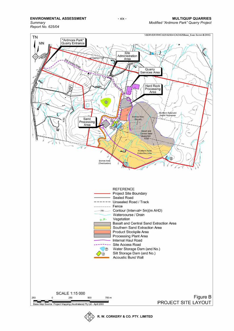
PROJECT SITE OPERATIONS Project Site Layout and Activities The proposed layout of the Project Site is presented in Figure B, and if approved, would involve the following component activities. • A site establishment phase during
which an acoustic bund wall, Project Site roads, buildings, fixed plant and hardstands would be constructed.
• Installation of a range of services, structures and transportable buildings.
• Extraction of sand and hard rock resources from an area of 46.8ha.
• Processing of the sand (by both dry screening and washing) and basalt within designated processing areas.
• Stockpiling of quarry products within a three-tiered hardstand area.
ENVIRONMENTAL ASSESSMENT - xix - MULTIQUIP QUARRIES Summary Modified “Ardmore Park” Quarry Project Report No. 625/04
R. W. CORKERY & CO. PTY. LIMITED
Figure B – Project Site Layout (A4/colour)
MULTIQUIP QUARRIES - xx - ENVIRONMENTAL ASSESSMENT Modified “Ardmore Park” Quarry Project Summary Report No. 625/04
R. W. CORKERY & CO. PTY. LIMITED
• Placement of silt produced through the sand washing plant in silt cells constructed within the completed sections of the extraction area.
• Importation of Virgin Excavated Natural Material (VENM) to provide additional material to backfill completed sections of the extraction area and enable the creation of a final landform with an elevation and slopes consistent with those of the pre-Project environment.
• Progressive rehabilitation of the final landform through final profiling, soil replacement and revegetation with both pasture and native woodland vegetation.
The transportation of quarry products from the Project Site to markets in Sydney, South Coast, Canberra and Goulburn, and activities associated with the upgrading, construction and maintenance of the transport route are considered separately under the heading “Transport Operations”. The Resources An assessment of the Project Site geology in conjunction with an exploration drilling program identified a sand resource near the surface in the southern section of the Project Site, which continues beneath a relatively thick sequence of basalt within the central and northern sections of the Project Site. The sand resource targeted for extraction has been estimated as 6.3 million tonnes and the basalt (hard rock) resource estimated as 9 million tonnes (92% of which would be suitable for the production of quality construction or road building materials). Extraction Area Design Based on the location and quantity of the sand and basalt resources, Multiquip proposes to extract both resources concurrently, initially within two separate extraction areas but ultimately combining to
form a single extraction area. The factors influencing the extraction area design are summarised as follows. Geological Factors The geometry of the resources themselves dictate the maximum depth of extraction, with a silty clay layer below the sand resource defining the ultimate quarry floor. The thickness of the basalt and sand layers thin noticeably to the south and west, providing a natural limit of extraction in these directions. To the east, an increasing stripping ratio limits the potential for extraction beyond the defined extraction area while to the north and northeast, it is recognised that the resources continue, however, the extraction area boundary is limited by the extent of exploration undertaken to date. Environmental Factors Aspects of visibility, the presence of native vegetation, identified items of Aboriginal heritage significance and the location of the Project Site within the Sydney drinking water catchment all influenced the overall design of the proposed quarry.
Site Establishment A 4 to 6 month site establishment phase would be undertaken in conjunction with initial extraction activities. This phase would include construction or installation of internal roads, bund walls, water storages and management structures, hardstand areas, processing plants, Project Site buildings and a weigh bridge, the locations of which are identified on Figure B. Notably, a revised location of the Project Site entrance has required the re-alignment of the Site Access Road from the existing property access road.
During the site establishment phase, and for a limited period following this phase, basalt extracted would be crushed using a mobile crushing plant.
ENVIRONMENTAL ASSESSMENT - xxi - MULTIQUIP QUARRIES Summary Modified “Ardmore Park” Quarry Project Report No. 625/04
R. W. CORKERY & CO. PTY. LIMITED
Extraction Operations The extraction areas have been designed to enable extraction to occur to various depths based on the naturally varying base levels and thickness of the sand and basalt resources. Extraction activities would involve the sequential removal of the vegetation, soil and overburden followed by the extraction of the sand and basalt resources. Vegetation Removal Clearing of vegetation would be undertaken on a progressive campaign basis, with the extent of clearing undertaken in each campaign sufficient for the subsequent year of quarry development. A bulldozer would be used to clear the isolated trees with grass and other groundcover removed with the topsoil during soil removal activities. Soil Removal Bulldozers would be used to strip the topsoil and subsoil from all areas of the Project Site to be disturbed. Wherever possible, the stripped soil would be transferred directly to completed areas of the final landform for respreading. Where this is not possible, the topsoil and subsoil would be stockpiled separately and at locations away from, or protected from, natural or constructed drainage lines. Overburden / Interburden Removal Minimal quantities of predominantly weathered basalt overburden are present over the recoverable sand and basalt resources. This material would be ripped prior to loading to trucks for use in the construction of bund walls, silt cells, internal roads and ultimately in the backfilling of the quarry to create the final landform. Southern Sand Extraction The quarry has been designed to maximise the recovery of sand, be free-draining and provide optimum capacity for silt storage and consolidation. The quarry design parameters would comprise 70o operational
quarry faces which would be reduced to 45o and 30o for the final faces on the completed quarry. Final benches, approximately 5m wide, would be developed at approximately 8m - 10m intervals.
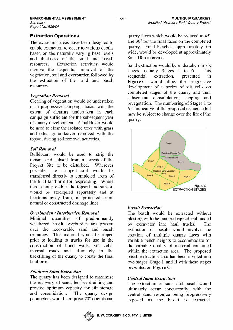
Sand extraction would be undertaken in six stages, namely Stages 1 to 6. This sequential extraction, presented in Figure C, would allow the progressive development of a series of silt cells on completed stages of the quarry and their subsequent consolidation, capping and revegetation. The numbering of Stages 1 to 6 is indicative of the proposed sequence but may be subject to change over the life of the quarry.
Figure C Basalt Extraction The basalt would be extracted without blasting with the material ripped and loaded by excavator into haul trucks. The extraction of basalt would involve the creation of multiple quarry faces with variable bench heights to accommodate for the variable quality of material contained within the extraction area. The proposed basalt extraction area has been divided into two stages, Stage I, and II with these stages presented on Figure C. Central Sand Extraction The extraction of sand and basalt would ultimately occur concurrently, with the central sand resource being progressively exposed as the basalt is extracted.
MULTIQUIP QUARRIES - xxii - ENVIRONMENTAL ASSESSMENT Modified “Ardmore Park” Quarry Project Summary Report No. 625/04
R. W. CORKERY & CO. PTY. LIMITED
Extraction of the central sand resource would generally progress southwards and eastwards with the exact sequence of extraction ultimately dictated and limited by the progression of the basalt extraction. Products and Processing Operations While extraction operations for the sand and basalt resources would be ultimately combined, the processing operations would remain independent for the life of the proposed quarry. Sand Products and Processing The principal sand product that would be produced at the “Ardmore Park” Quarry would be for use in the manufacture of concrete. Based upon a review of laboratory analyses and an initial market assessment, it is anticipated 30% of the sand extracted would only require dry screening through a mobile plant consisting of a vibrating screen and conveyor. The mobile plant would be located within the extraction area and repositioned as required to minimise haul distances for quarry mobile plant.
The remaining 70% would be processed through a sand washing plant, to be located on a hardstand area immediately west of the Southern Sand Extraction Area. This plant would incorporate a vibrating screen, silt pump, dewatering screen and radial stacker. The water requirements would vary annually depending on the amount of sand washed but would not exceed 84ML per year or 270kL per day.
Silt and waste water from the sand washing plant would be pumped to silt cells which would be constructed on the floor of the completed extraction stages. This water, after being allowed to clarify, would be reused through the sand washing plant with each silt cell eventually consolidated, capped and revegetated.
Hard Rock Products and Processing Two main hard rock products would be produced, namely: • aggregate material used in the
manufacture of concrete and asphalt; and
• road base or road construction materials.
The hard rock processing plant, incorporating a primary, secondary and several tertiary crushers, variously sized screens, conveyors and stockpile areas, would be located on a hardstand area. All noise and dust generating components would be enclosed leaving small openings for the plant conveyors and staff access. The bulk of the undersize material produced would be used in construction and/or capping of silt cells or blending with the sand resource to produce proprietary products suited to individual customer requirements. Production Rates The annual production rate of sand and hard rock products would typically vary in response to market conditions, however, the combined production of sand and basalt would not exceed 400 000tpa. Notably, a number of the sand products will incorporate a proportion of the<5mm basalt fines. Product Stockpiling Sand products would be predominantly stockpiled adjacent to or beneath the radial stacking conveyor within the Sand Processing Area or in temporary stockpiles on the quarry floor. Additional stockpiles may be maintained within the product despatch road loop to ensure a sufficient quantity of the various sand products remain available, even during periods when basalt is the primary resource being extracted.
ENVIRONMENTAL ASSESSMENT - xxiii - MULTIQUIP QUARRIES Summary Modified “Ardmore Park” Quarry Project Report No. 625/04
R. W. CORKERY & CO. PTY. LIMITED
The hard rock products would be stockpiled within a three tiered stockpile area to the immediate south of the hard rock processing plant, providing for up to 30 000t of stockpiled products. On-site Transportation In order to accommodate the new Project Site entrance, a new section of road would be constructed between Oallen Ford Road and the existing “Ardmore Park” access road, generally following the 845m AHD contour.
An internal road network would be maintained with the roads designated as either:
(i) the transport route for road registered trucks transporting products from the quarry;
(ii) long-term internal haul roads between the active extraction activities and processing plants; or
(iii)internal access roads for the movement of light vehicles, earthmoving equipment and internal haulage of raw materials predominantly within the extraction areas.
Infrastructure and Services The Project would require the development of, or modification to existing, infrastructure and services. Infrastructure to be constructed erected or modified would include: • the sand and hard rock processing
plants;
• a quarry services area including a workshop, fuel storage and parking area; and
• a site administration area including the modification of the “Ardmore Park” residence and shearer’s quarters to provide technical offices and meal
rooms and the erection of demountable buildings for shower and ablution facilities.
Services to be installed or upgraded to the “Ardmore Park” property include the following.
• Power - to be sourced from the existing service and on-site diesel generators.
• Communications – to utilise the existing phone lines to the property, supplemented by mobile and 2-way communications.
• Potable Water – to be sourced predominantly from rainwater captured and stored in tanks and supplemented from commercial sources.
• Fuel – to be stored in an above ground 20 000L tank within the quarry services area.
• Sewage – the proposed quarry would use a combination of the existing “Ardmore Park” septic system and a new biocycle sewage treatment system.
Employment The operation of the proposed “Ardmore Park” Quarry would require the progressive employment of up to 10 persons on the Project Site and an additional 16 truck drivers. Hours of Operation and Project Life The proposed hours of operation for all project-related activities are as follows.
• Monday to Friday − 7:00am to 6:00pm.
• Saturday − 7:00am to 1:00pm.
• Operations on public holidays would be excluded.
MULTIQUIP QUARRIES - xxiv - ENVIRONMENTAL ASSESSMENT Modified “Ardmore Park” Quarry Project Summary Report No. 625/04
R. W. CORKERY & CO. PTY. LIMITED
When necessary, general maintenance to the processing plants and mobile equipment may be undertaken outside these hours.
The life of the Project is based on the production of up to 400 000t of sand and hard rock per year from the estimated sand and hard rock resources of 6.3Mt and 9Mt respectively. Assuming maximum production for 75% of years and 75% production for the remaining years, the approximate life of the identified resources within the extraction area would be at least 30 years. Waste and VENM Management The principal wastes that would be generated by the Project Site operations can be categorized as production by-products and non-production wastes. Production by-products such as overburden, oversize material and fines produced by the processing plants would be used in the construction of bund walls, water storage dams and other Project Site infrastructure, the construction and capping of silt cells, blending to create sand products to meet particular specifications and ultimately in the creation of the final landform.
Non-production wastes would include general domestic-type wastes from the on-site buildings, routine maintenance consumables, and oils and grease. Domestic-type wastes and waste fuel and oils would be collected and disposed of by a licenced waste disposal contractor(s) with recyclable materials separated where possible.
In order to assist in the backfilling of the void created within the extraction area void and to create a final landform similar to that of the pre-Project environment, Multiquip proposes to import increasing quantities of Virgin Excavated Natural material (VENM) to the Project Site. Multiquip estimates that 5 650 000m3 of material would be required to backfill and rehabilitate the extraction area of which approximately 3 250 000m3
would be provided by the production by-products. During the first four to five years of the Project, it is anticipated that up to 20 000tpa of VENM would be required to provide a cover of approximately 2m over the completed silt cells (prior to respreading of overburden and soil). Therefore, in order to create the proposed final landform, Multiquip would increase VENM importation would increase to 40 000tpa between years 5 and 15, and up to 70 000tpa for the remaining years of the Project.
All VENM would be backloaded by product delivery trucks, thereby not increasing the number of truck movements generated by the Project
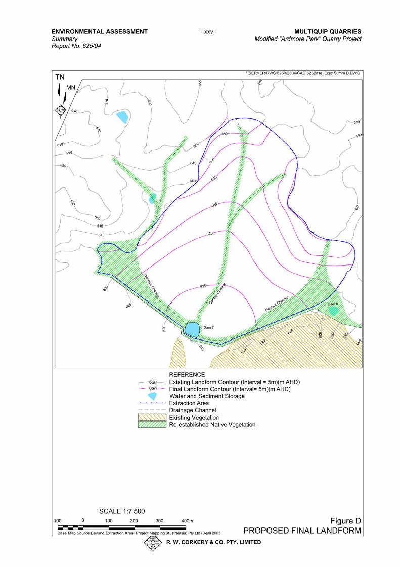
Rehabilitation and Final Land Use Multiquip proposes to create a final landform that replicates the gently undulating topography of the existing Project Site environment (see Figure D). The final landform would be free-draining to the south with dams constructed for the storage and clarification of water retained to assist in the Project Site’s suitability for future agricultural activities. Rehabilitation would be undertaken progressively over the life of the proposed quarry.
Rehabilitation procedures for the proposed quarry extension would be in accordance with local and NSW government agency requirements. The open areas of the final landform would be revegetated with grass and pasture species, with native trees planted around the edges of the dams and drainage lines and adjacent to the undisturbed native bushland to the southeast of the Project Site. The quarry perimeter and benches would be revegetated with native tree and shrub species to assist in the stabilisation of these areas and improving the visual amenity of the final landform.
ENVIRONMENTAL ASSESSMENT - xxv - MULTIQUIP QUARRIES Summary Modified “Ardmore Park” Quarry Project Report No. 625/04
R. W. CORKERY & CO. PTY. LIMITED
Figure D – Proposed Final Landform (A4/colour)
MULTIQUIP QUARRIES - xxvi - ENVIRONMENTAL ASSESSMENT Modified “Ardmore Park” Quarry Project Summary Report No. 625/04
R. W. CORKERY & CO. PTY. LIMITED
Figure D presents a conceptual illustration of the proposed final landform. This landform assumes the importation of the proposed 2 400 000m3 of VENM to the Project Site over the life of the Project.
TRANSPORT OPERATIONS As part of the modified project, Multiquip has committed to transporting all quarry products using truck and trailer style vehicles between the Project Site and the Hume Highway via Oallen Ford Road (3.8km), a private by-pass route around Bungonia Village (1.8km), Mountain Ash Road (0.15km) and Jerrara Road (14.7km), where they would be distributed to the north to markets in Sydney, South Coast, Canberra, Goulburn and surrounding areas.
Figure E displays the transport route from the Project Site to the Hume Highway with an inset displaying the alignment of the proposed Bungonia Village By-pass, which commences approximately 0.5km south of Bungonia Village, traverses private land (Lot 2, DP 735523 and Lot 82, DP 1117175), Bungonia Creek (via a new bridge) and Crown land (within a 20m wide corridor located on the western boundary of the Crown land) before joining Mountain Ash Road, 250m west of its intersection with Jerrara Road. In order to gain a better understanding of the existing road alignment and possible road improvements necessary to facilitate safe and low impact use by quarry trucks, Multiquip commenced a comprehensive survey of all sections of the roads that would be used by quarry trucks. The survey information was considered by Multiquip and Council and, based on a review of the detailed survey information and discussions held during an inspection of the three public roads, the following assessments were made.
(i) The existing pavement width generally varied between 6.0m and 7.0m.
(ii) With limited exceptions, a formed gravel shoulder is present on either side of the sealed pavement which increases the road width to 8m.
(iii) While the pavement width was identified as less than the minimum desired standard of Council (8m), the existing alignment was considered to be close to optimal.
In order to minimise the impact of heavy vehicle movements on the local public road network, Multiquip proposes to undertake a series of road upgrade works over the public sections of the transport route, ie. Jerrara Road, Mountain Ash Road and Oallen Ford Road. These upgrades would include the following works.
(i) Widening the sealed pavement of public sections of road to provide an 8.0m sealed carriageway (3.5m lane + 0.5m shoulder).
(ii) Constructing new intersections between public roads with the Site Access Road and Bungonia By-pass to the minimum standard recommended by the RTA’s Road Design Guide.
(iii) Upgrading selected water course crossings to ensure the safe pass-by of vehicles. Give Way signage would be erected until such time as the recommended upgrades are completed.
The Bungonia By-pass would be designed and constructed with a 6m sealed surface (5m of sealed lane pavement and 0.5m of sealed shoulder either side of the lanes) and would include a single lane bridge crossing of Bungonia Creek. The proposed alignment of the Bungonia By-pass would:
• provide a sufficient buffer to Bungonia Village;
• minimise the length of the by-pass; and
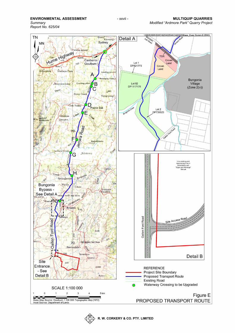
ENVIRONMENTAL ASSESSMENT - xxvii - MULTIQUIP QUARRIES Summary Modified “Ardmore Park” Quarry Project Report No. 625/04
R. W. CORKERY & CO. PTY. LIMITED
Figure E – The Proposed Transport Route (A4/colour)
MULTIQUIP QUARRIES - xxviii - ENVIRONMENTAL ASSESSMENT Modified “Ardmore Park” Quarry Project Summary Report No. 625/04
R. W. CORKERY & CO. PTY. LIMITED
• traverse land which Multiquip can obtain ownership, or negotiate usage rights.
To further minimise the potential impact of the proposed transport operations, Multiquip has committed to a four stage construction schedule for the proposed transport route. The volume of traffic generated by the Project would be linked to the successful completion of each stage as follows.
Stage 1: Bungonia By-pass and Intersections
Stage 1 would be commenced immediately on receipt of project approval and would be undertaken in conjunction with site establishment activities on the Project Site. The main activities of Stage 1 would include:
• the construction of the Project Site entrance with Oallen Ford Road;
• the construction of the Bungonia By-pass;
• the construction and upgrading of the intersections of transport route; and
• the installation of “Give Way” signs on the southbound approach to selected watercourse crossings.
On completion of Stage 1 road works, the transportation of quarry products would commence but be limited to 10 truck loads per day.
Stage 2: Pavement Widening and Public Road Upgrades
Stage 2 road works would include: • the widening of the sealed pavement
of the public roads to a width of 8.0m;
• the rehabilitation of those sections of pavement identified as having a pavement life of less than 10 years; and
• the completion of centreline and edge marking over the entire length of the transport route.
On successful completion of the proposed works, the number of truckloads would increase to the maximum 28 per day.
Stage 3: Water Course Crossing Upgrades
While the road widening works are undertaken, Multiquip would also upgrade selected watercourse crossings to a standard which would allow the safe pass-by of vehicles. On completion of these works, it is proposed to increase product transportation to the maximum level, ie. 44 truck loads per day.
Stage 4: General Maintenance
Multiquip would provide for, through section 94 contributions to Goulburn Mulwaree Council, the maintenance and remediation of the transport route throughout the life of the quarry. Stage 4 works would be ongoing throughout the life of the quarry.
Multiquip would use a modern, well maintained fleet of heavy vehicles fitted with the most up-to-date emission control technology. These vehicles, which would typically be “truck and trailer” style vehicles with a maximum Gross Carriage Mass (GCM) of approximately 50t, would be inspected regularly and drivers would be expected to follow a strict code of conduct. All heavy vehicles would also be equipped with GPS tracking equipment to ensure driver compliance with speed limits along the transport route to and from the Highway.
Multiquip anticipates that trucks would be despatched from and arrive at the Project Site at the rate of between 0 and 14 movements per hour, with a maximum of four truck movements every 15 minutes.
ENVIRONMENTAL ASSESSMENT - xxix - MULTIQUIP QUARRIES Summary Modified “Ardmore Park” Quarry Project Report No. 625/04
R. W. CORKERY & CO. PTY. LIMITED
To restrict access of non Project-related vehicles, Multiquip would install a set of automatic gates at each end. The gates would be opened using a swipe card system, with each contracted truck driver issued with a card on their initial entry to the Project Site. In order to ensure that new drivers traveling to the Project Site are able to use the Bungonia By-pass, an intercom system would be installed, with the gates able to be opened remotely from the Project Site weighbridge or office.
ISSUE IDENTIFICATION AND PRIORITISATION In order to undertake a comprehensive Environmental Assessment of the Project, appropriate emphasis needs to be placed on those issues likely to be of greatest significance to the local environment, neighbouring landowners and the wider community. These issues (and their potential impacts) were identified through a review of consultation undertaken as part of the previous development application, submissions to the original development applications, proceedings of a Land and Environment Court hearing (Hearing 10245 of 2006) and, more recently, consultation with the local Council and NSW government agencies.
Based on the environmental issues raised throughout the consultation and review process, a review of the Project design and local environmental features was undertaken to identify risk sources and potential environmental impacts for each environmental issue. An analysis of risk for each potential environmental impact was then completed, with a risk rating assigned to each impact based on likelihood and consequence of occurrence in the absence of any mitigation measures. Through a review of the allocated risk ratings and the frequency with which each issue was identified, the relative priority of each issue
was determined, with this priority used to provide an order of assessment and depth of coverage within the Environmental Assessment.
Based on the issues identified and the risk ratings allocated, the following order of priority has been determined.
1. Traffic.
2. Water Resources.
3. Noise and Vibration.
4. Air Quality.
5. Flora and Fauna.
6. Heritage.
7. Visual Amenity.
8. Soils and Land Capability.
9. Rehabilitation, Final Landform and Land use.
It is recognised that the potential impact of the Project on local ‘amenity’ has been identified as a major issue by the local community. Noting that impact on local amenity is subjective and is therefore difficult to definitively assess, an evaluation of all tangible and intangible contributors to local amenity values has been included in this Environmental Assessment, and a conclusion as to the likely impact on amenity presented.
ENVIRONMENTAL SAFEGUARDS AND IMPACTS The components and features of the existing environment within and around the Project Site have been studied in detail to understand how the proposed operations within the Project Site and associated transport operations can best be designed to avoid or minimise impacts on the surrounding environment. A brief overview of the main components of the surrounding environment and the assessed level of impact is set out below.
MULTIQUIP QUARRIES - xxx - ENVIRONMENTAL ASSESSMENT Modified “Ardmore Park” Quarry Project Summary Report No. 625/04
R. W. CORKERY & CO. PTY. LIMITED
Traffic and Transport The Project Site is located with a surrounding local road network servicing predominantly light vehicle traffic generated by local residents travelling to and from the major centre of Goulburn or the Hume Highway. Traffic counts undertaken on these roads between 2004 and 2006 indicate that local public roads currently carry less than 400 vehicles per day (vpd) (more on the weekends and less mid-week) with heavy vehicles making up approximately 10% of total traffic. It is noted that a significant increase in this volume of traffic is very unlikely to occur in the foreseeable future.
Based on the existing traffic levels on the roads to be incorporated into the proposed transport route, and the proposed traffic generation of the Project, it is anticipated that average daily traffic would not exceed 500vpd. Considering this predicted level of traffic, a restricted truck speed limit of 80km/hr, and the proposed road construction and upgrading works, the potential impact of the transport operations are as follows.
Intersection Design and Performance The proposed intersections to be constructed or upgraded were reviewed against the recommended standard for lane and shoulder width, acceleration / deceleration lanes and SISD of the RTA’s Road Design Guide. An INTANAL intersection analysis for the peak hours of daily traffic, eg. 8:00am to 9:00am, 3:30pm to 4:30pm was also undertaken and results compared to the level of service (LOS) indicators nominated by the RTA’s Guide to Traffic Generating Developments.
For all intersections of the transport route, it was concluded that the minimum SISD, and acceleration / deceleration turning lane width and length met the recommendations of the Road Design Guide. The results of
the INTANAL intersection analysis indicated a LOS A, ie. good operation with a delay of <14s, for each intersection.
Carriageway Width The proposed road upgrading and construction works were reviewed against the Road Design Guide recommendations for lane and shoulder widths and the draft DCP standards of Goulburn Mulwaree Shire Council.
Considering the Proponent has committed to upgrading the public roads of the proposed transport route to meet the Road Design Guide recommendations for traffic of 500 to 2 000vpd, ie. lane width of 3.5m with 0.5m shoulder on both sides, the carriageway width would be more than adequate for the proposed level of traffic proposed.
Bridges and Culverts The Road Design Guide recommends a carriageway width of 6.0m plus 1.0m shoulders, ie. the total width between either the kerb edges or the barrier faces to be 8.0m, for traffic flows up to 500vpd.
A survey of the public roads of the proposed transport route commissioned by the Proponent identified eight bridge or culvert crossings of watercourses requiring specific upgrade requirements in order to meet this standard. Multiquip has committed to undertaking these upgrades as part of the Stage 3 road works, and as such would ensure that the recommended standard is achieved.
Other impacts of the proposed transport operations on other traffic related issues including: road geometry; road conditions in extreme weather conditions, and local school bus services have been considered. In each case, the proposed operations would not have an adverse effect and would potentially improve existing conditions through the proposed road upgrades.
ENVIRONMENTAL ASSESSMENT - xxxi - MULTIQUIP QUARRIES Summary Modified “Ardmore Park” Quarry Project Report No. 625/04
R. W. CORKERY & CO. PTY. LIMITED
Surface Water Project Site Operations The Project Site is located within the Sydney drinking water catchment with surface water flows reporting to both the Bungonia Creek and Nerrimunga River sub-catchments of the Shoalhaven River. In order to ensure the proposed operations had a neutral or beneficial impact on water quality, Multiquip has included a number of water diversionary, settlement and storage structures around the proposed areas of disturbance.
Assuming the construction and maintenance of these structures, the MUSIC model was run to determine the water quality of each active component of the Project Site operations, eg. processing areas, extraction area, before and following commencement of the Project. The modelling results indicated that in each case, the impact of the proposed operations would have a neutral or beneficial impact on water quality.
The proposed Project Site operations would also change the hydrological nature of the local catchments by creating impervious surfaces and reducing the infiltration rate on the hardstand and other impervious surfaces created. The MUSIC model was used to estimate the available runoff, pre- and post-Project Site operations. The results of the modelling suggested that downstream flows could be maintained at approximately current rates while capturing up to 38.5ML of water which could be used for operational or environmental purposes. Transport Operations The impact of the proposed transport operations on local surface water was also investigated. In summary.
• Roadside drainage is inconsistent, with erosion evident at a number of locations. The proposed drainage crossing design measures to be progressively implemented as part of the upgrading and construction works
would reduce the prevalence of this uncontrolled sheet flow and thereby lead to an improvement in erosion and sediment control over the length of the transport route.
• The proposed Bungonia Creek Crossing would be constructed with minimal impact on the existing waterway by spanning the bridge in two spans of 11m. By requiring only a single circular pile and headstock within the creek itself, the disturbance to the aquatic corridor would be minimised. In addition, box culverts on either side of the crossing would maintain the terrestrial corridor.
• Assuming the establishment of at least 5ha of native vegetation as part of progressive Project Site rehabilitation, MUSIC modelling completed by SMM (2008) confirms that the proposed transport operations would have, at worst, a neutral impact on local water quality.
Groundwater Four types of aquifers are recognised within the local area.
1. Hard rock (“basalt”) aquifers associated with the Tertiary basalt.
2. Alluvial aquifers associated with alluvial deposits beneath the base of the basalt.
3. Basement rock (“fractured”) aquifers associated with geological discontinuities of the basement rocks underlying the basalt.
4. Basement rock (“karstic”) aquifers associated with the limestone units (karst) hosted by basement sedimentary rocks.
The proposed production bore that would supply groundwater to the sand washing plant would draw water from a fractured aquifer within the basement rocks. A 46-hour pump test and analysis of
MULTIQUIP QUARRIES - xxxii - ENVIRONMENTAL ASSESSMENT Modified “Ardmore Park” Quarry Project Summary Report No. 625/04
R. W. CORKERY & CO. PTY. LIMITED
drawdown and recovery in this and surrounding bores indicated that the proposed rate of pumping to supply the water requirements to the proposed quarry would be unlikely to significantly impact on the groundwater of this aquifer or surrounding aquifers.
A hydrogeological investigation undertaken determined that whilst insignificant quantities of water would be held in the basalt to be extracted, the extraction of sand would result in the removal of between 6ML to 25ML of groundwater from the identified upper alluvial aquifer each year (0.9% and 3.6% of the total groundwater storage in the combined sand resource). However, based on conservative estimates of annual recharge, it is suggested that this volume of groundwater would represent between 8.1% and 42.0% of annual recharge. It is concluded that the saturated unconsolidated sand mass would rapidly equilibrate and there would be minimal impact on the overall groundwater resource.
The potential impact of the proposed sand extraction on local spring flows was also investigated. Based on groundwater flows, and the distinct chemical characteristics of the various water sources of groundwater, it was determined that the groundwater within the sand resource to be extracted and that in several identified springs in the area are separate. Therefore, the extraction of the sand resource would be unlikely to significantly impact on the production of water from these springs.
Notwithstanding these assessments, Multiquip has committed to a comprehensive monitoring program of groundwater availability and quality. In the event that monitoring indicates surrounding groundwater users have been adversely impacted as a result of the Project, compensation would be negotiated.
Noise Project Site Operations The existing sources of noise around the Project Site are typical of a rural environment. Rating background noise levels were therefore assumed to be no greater than 30dB(A).
The criteria for noise generated by the Project have been established as:
• an LAeq(15min) 10dB(A) above the assumed background levels during the construction phase; and
• an LAeq(15min) 5dB(A) above the assumed background levels for the proposed Project Site operations.
Following the incorporation of noise controls including the location of noise-generating activities to maximise natural shielding through the existing topography and the enclosure of various hard rock processing plant components, no exceedances of these noise criteria were predicted.
Notwithstanding the predicted compliance with all noise criteria, Multiquip would monitor noise levels and maintain dialogue with the potentially affected residents to ensure that the noise-related impacts are minimised and all practical noise reducing controls are incorporated into the operation of the proposed quarry.
Transport Operations
The assessment of noise associated with the proposed transportation operations considers the noise generated by traffic on the existing public road network against the requirements of the NSW Environmental Criteria for Road Traffic Noise (ECTRN), as well as the noise generated by the operation and construction of the private Bungonia By-pass against the relevant sections of the DEC Environmental Noise Control Manual and the Industrial Noise Policy.
ENVIRONMENTAL ASSESSMENT - xxxiii - MULTIQUIP QUARRIES Summary Modified “Ardmore Park” Quarry Project Report No. 625/04
R. W. CORKERY & CO. PTY. LIMITED
Road Traffic Noise on Public Roads
Transport operations would be restricted to daytime hours only. As such the appropriate traffic noise criterion (as defined by the ECTRN) is an LAeq(1hour) of 55dB(A).
Based on attended noise measurements taken for the laden and unladen trucks, known offset distances of residences to the proposed transport route, measured existing traffic levels and predicted maximum hourly traffic generated by the Project, the LAeq(1hour) noise emissions of the proposed transport operations at the residences located along the proposed transport route were calculated.
The calculated noise levels would easily comply with the ECTRN noise criterion, the highest predicted noise level being 49dB(A) at a 35m offset from Jerrara Road.
Bungonia By-pass Noise
Background noise measurements recorded in 2004, established a background noise level (LAeq) of 43dB(A) within the village of Bungonia. A background noise level at residences situated on the outskirts of the village was assumed to be 35dB(A).
Based on the established background noise levels, and a construction period of less than 4 weeks (adjacent to any given receiver), the criteria for noise generated by the construction and operation of the Bungonia By-pass have been established as:
• an LAeq(15min) 20dB(A) above the assumed background levels during the construction phase; and
• an LAeq(15min) 5dB(A) above the assumed background levels for the proposed transport operations.
Noise modelling completed for two worst-case construction scenarios and an operational scenario (at maximum traffic levels) has demonstrated that the noise received at the closest residences to the
Bungonia By-pass would be 6dB(A) and 8dB(A) below the nominated criteria for the construction and operational scenarios respectively. These noise levels would result in a very minor, if not imperceptible change to local noise levels.
Air Quality The air quality assessment concluded that the adoption of air quality control measures including dust suppression, enclosure of various processing plant components, progressive rehabilitation and minimisation of clearing in advance of operational activities would ensure any increases to PM2.5, PM10, and dust deposition would satisfy DECC and other government agency environmental and health criteria.
No adverse impacts associated with respirable crystalline silica dust are likely to affect the residents surrounding the Project Site and there would be no significant generation of odour as a result of the Project.
Flora and Fauna Project Site Operations The majority of the “Ardmore Park” property has been cleared for grazing with the dominant vegetation communities being grassland with occasional trees. Two areas of remnant native forest occur within the Project Site in areas that would not be cleared. Small clumps and rows of pines and planted trees are also present on the Project Site.
No threatened species or populations were identified on the Project Site although the native vegetation remnants identified within the Grassland with Occasional Trees community are potentially a remnant of the endangered White Box Yellow Box Blakely’s Red Gum Woodland community that is likely to have been present on the Project Site prior to clearing. Two
MULTIQUIP QUARRIES - xxxiv - ENVIRONMENTAL ASSESSMENT Modified “Ardmore Park” Quarry Project Summary Report No. 625/04
R. W. CORKERY & CO. PTY. LIMITED
threatened bird species, the Speckled Warbler and the Diamond Firetail, were identified on the Project Site.
Seven-part tests of significance were completed for the threatened community and species and it was concluded that the Project Site operations would be unlikely to impact on these community/species, given that disturbance on the Project Site would be largely limited to previously cleared areas. The revegetation of selected areas of the Project Site with native woodland vegetation would more than compensate for the temporary disturbance attributable to the extraction activities.
Transport Operations A ribbon of remnant native vegetation exists within the corridor of the proposed transport route over the majority of its length. This includes two small sections of woodland considered a remnant of the endangered White Box Yellow Box Blakely’s Red Gum Woodland community. Two threatened species of microchiropteran bat were also identified within the proposed transport route corridor.
Seven part tests of significance were completed for the threatened community and species and it was concluded that the transport operations would be unlikely to impact on these community/species, given the minimal clearing required over the length of the transport route.
Cultural Heritage Project Site Operations An assessment of the Aboriginal heritage of the Project Site identified two isolated artefact scatters to the north of the proposed area of disturbance. These scatters, together with one previously identified nearby, would not be affected by the Project Site operations. It was noted, however, that the soils over the southern sand resource have the potential to contain sub-surface deposits of artefacts of Aboriginal heritage
significance. Whilst not necessarily a constraint on the operation, the appropriate permit and investigations would be obtained and undertaken prior to commencement of extraction over the southern sand resource and any identified artefacts recorded and managed appropriately.
No items of European heritage significance, including any evidence of the “Old Argyle Road” identified on a number of old maps as traversing the Project Site (GSA Planning (2007), were identified on the Project Site. All known heritage sites occur in excess of 700m from the Project Site and would not be impacted by the proposed operations.
Transport Operations An assessment of Aboriginal heritage of the proposed transport route identified six Aboriginal artefacts or artefact scatters and one Potential Archaeological Deposit (PAD) within or adjacent to the proposed transport route corridor. With the exception of the PAD, all sites would be avoided by the alignment of the transport route. Whilst not necessarily a constraint on the operation, the appropriate permit and investigations would be obtained and undertaken prior to commencement of road construction over the PAD and any identified artefacts recorded and managed appropriately.
The proposed by-pass of Bungonia would ensure that the heritage value of the many registered heritage sites within the village would remain unaffected. The proposed alignment would, however, pass within 50m of “the Parsonage”, a single storey, Georgian vernicular stone and cedar building, constructed in 1840 (circa) and listed under the draft Goulburn Mulwaree LEP. It was concluded, however, that assuming the appropriate safeguards are adhered to during road construction, the proposed transport operations would not have an adverse impact on this or any other item of European heritage significance.
ENVIRONMENTAL ASSESSMENT - xxxv - MULTIQUIP QUARRIES Summary Modified “Ardmore Park” Quarry Project Report No. 625/04
R. W. CORKERY & CO. PTY. LIMITED
Visibility A number of residences surrounding the Project Site would have views of varying distance and obscurity of the proposed activities. The majority of these would be screened naturally by the local topography and vegetation with a vegetated bund to be constructed around the western and southern perimeter of activities assisting in further reducing the impact on the visual amenity of neighbouring residences. The increase in heavy vehicle movements along local roads would also have a minor impact on visual amenity although neither impact is considered unacceptable.
Socio-economic Setting Through a program of consultation, it has been determined that the local community places a high degree of value on the aesthetic value of their surroundings, with the generation of income from the local area a secondary consideration for many residents. The Project would undoubtedly create employment and provide a small boost for the local government area of Goulburn Mulwaree as a whole, however, it is not considered that this would be at an unacceptable cost to the amenity and/or land values of those living in close proximity to either the Project Site or proposed transport route. PROJECT EVALUATION The modified “Ardmore Park” Quarry Project has been evaluated and justified principally through consideration of its potential impacts on the environment and potential benefits to the local and wider community.
An evaluation of the Project has been undertaken by firstly reassessing the risks posed to the local environment by Project-related activities following the implementation of all operational controls, safeguards and/or mitigation measures, and
secondly through consideration of the principles of ecologically sustainable development.
Residual Environmental Risk and Impacts With the implementation of the proposed operational controls, safeguards and/or mitigation measures, the residual risk posed by each possible environmental incident or impact was reduced from its original level, and with limited exception, classified as either moderate or low, and therefore acceptable.
Principles of Ecologically Sustainable Development The design of the Project has addressed each of the sustainable development principles, and on balance, it is concluded that the modified “Ardmore Park” Quarry Project achieves a sustainable outcome for the local and wider environment.
Impacts on Issues Influencing Local Amenity Justice Jagot J referred to amenity as “… a wide and flexible concept embracing such matter as the character of a place and the attributes of a place which a community values as important contributors to its character…”
On the basis of this description, issues influencing the ‘amenity’ of a place may include both tangible impacts on the local setting, ie. those impacts on the biophysical environment which can be measured, as well as more intangible elements, ie. impact on aspects of the local setting which are not easily quantified or directly measured.
A comprehensive list of tangible and intangible impacts on the local rural and village communities was prepared, with particular reference to the issues raised by the local communities during Hearing 10245 of the Land and Environment Court. Each issue was evaluated and residual impacts on either the Bungonia village
MULTIQUIP QUARRIES - xxxvi - ENVIRONMENTAL ASSESSMENT Modified “Ardmore Park” Quarry Project Summary Report No. 625/04
R. W. CORKERY & CO. PTY. LIMITED
community or surrounding rural community reviewed. On the basis of this evaluation, the following was concluded in relation to impacts on local amenity.
Amenity of Bungonia (Zone 2(v))
Notably, the Project in its entirety, including all transport operations, is located outside of Bungonia Village. Impacts attributable to the Project which may influence local amenity are predicted to be limited to:
• occasional noise associated with the construction of the by-pass road (which would be well below the nominated criteria);
• an increase in the number of heavy vehicles encountered on roads of the transport route (although this would be mitigated by the marked improvement in the standard, function and therefore safety of these same roads); and
• ongoing contribution from the Proponent to community based activities or requirements.
The Project has been evaluated as being highly likely to meet the objectives of the zone 2(v) and unlikely to result in any significant change to the amenity of Bungonia village.
Amenity of the Rural Zone (Zone 1(a)) The Project would have only minor impacts on a limited number of land owners and residents located immediately surrounding the Project Site or fronting onto the proposed transport route. These impacts would all comply with nominated environmental criteria (where available) with impacts either mitigated or offset by the commitments of the Proponent.
Importantly, the Project would not adversely affect the viability of existing land users in the local area and wider region nor would it encourage the use of surrounding lands for industrial or higher
intensity development. It is therefore considered complementary to existing rural activities.
The Project has been evaluated as being consistent with the objectives of the 1(a) zone and it is therefore considered highly unlikely that the Project would have an adverse impact on the amenity of a reasonable person residing in the local area or region within the 1(a) zone.
PROJECT JUSTIFICATION AND CONCLUSION The modified “Ardmore Park” Quarry Project has been designed to, as much as possible, address the issues of concern to the community and all levels of government. Should the Project proceed there would be some limited impacts on the local biophysical and (to a lesser extent) socio-economic environment. These impacts can be justified, however, when considering the following.
• The Project provides for the recovery of valuable sand and hard rock resources which are significant in the planning of resources available to the Sydney, South Coast, Canberra and local Goulburn markets.
• The Project would be significant in generating employment opportunities and boosting the local economies of Goulburn and the Shire of Goulburn Mulwaree.
• The Project would contribute to the improvement and maintenance of infrastructure (roads) in the local area.
• The rehabilitated final landform, created by the deposition, consolidation and capping of silt materials with limited quantities of imported virgin excavated natural materials, overburden, subsoil and topsoil, would be constructed to sustain long term agricultural or horticultural activity and manage all
ENVIRONMENTAL ASSESSMENT - xxxvii - MULTIQUIP QUARRIES Summary Modified “Ardmore Park” Quarry Project Report No. 625/04
R. W. CORKERY & CO. PTY. LIMITED
components of the local environment, particularly water management, air quality and soil issues.
• It has been demonstrated that the Project would have minimal impacts on the local amenity of Bungonia village and the surrounding rural community.
• The Project has addressed the issue of public road suitability for the level of transport proposed through the progressive upgrading of the sections of road to be incorporated into the transport route.
• The Project would satisfy sustainable development principles.

MULTIQUIP QUARRIES - xxxviii - ENVIRONMENTAL ASSESSMENT Modified “Ardmore Park” Quarry Project Summary Report No. 625/04
R. W. CORKERY & CO. PTY. LIMITED
This page has intentionally been left blank