Embed Size (px)
Citation preview

6.12 Microsculpturing of Solutional Rocky LandformsJ Lundberg, Carleton University, Ottawa, ON, Canada
r 2013 Elsevier Inc. All rights reserved.
6.12.1 Introduction 1226.12.1.1 Significance 1226.12.1.2 Basic Controls on Formation 1226.12.2 Major Karren Forms 1226.12.2.1 Solution Pits/Basins 1226.12.2.2 Rainpits 1236.12.2.3 Solution Pans (Kamenitzas) 1236.12.2.4 Solution Bevels (Ausgleichsflachen) 1246.12.2.5 Trittkarren (Heelprint Karren), Trichterkarren (Funnel Karren), and Lame Dentates (Sharpened Toothed
Edges) 1246.12.2.6 Microrills (Rillensteine) 1256.12.2.7 Rillenkarren (Solution Flutes) 1256.12.2.8 Rinnenkarren 1266.12.2.9 Decantation Runnels and Flutings, and Wandkarren (Wall Karren) 1276.12.2.10 Rundkarren 1286.12.2.11 Splitkarren, Grikes (Kluftkarren), Cutters, and Clints (Flachkarren) 1286.12.2.12 Subcutaneous Karren (Bodenkarren) 1306.12.2.13 Karren Wells 1306.12.2.14 Cavernous Karren/Subsoil Pits (Kavernosen Karren) 1316.12.2.15 Solution Notches (Korrosionskehlen) and Subcutaneous Half-Bells 1316.12.2.16 Solution Pipes (Geologische Orgeln) 1326.12.2.17 Spitzkarren 1326.12.2.18 Pinnacles 1326.12.3 Karren Assemblages 1326.12.4 Classification 1356.12.4.1 Classification Based on Physical and Chemical Properties of Solvent and Solute 1356.12.4.2 Important Karren Regions 1356.12.5 The Future 137References 137
GlossaryAggressivity This is the potential of a fluid to be corrosive
to the material under discussion. Aggressive water is not yet
saturated with a chemical (such as limestone) and can thus
dissolve more of that chemical.
Condensation corrosion This is the weathering/
dissolution of rock surfaces caused where vapor (commonly
water) condenses directly onto rock surfaces, causing
corrosion if the condensate is aggressive.
Eogenetic rock Young rocks that have not been buried by
later sediments, largely uncompacted, commonly poorly
cemented, and of high primary porosity.
Epikarst This is the network of intersecting fissures and
cavities from surface weathering on the upper surface of a
karst landscape that delivers surface water to the
underground drainage system, typically a few centimeters to
tens of meters deep.
Hortonian channel A channel that forms where rainfall
exceeds infiltration capacity and overland flow is focused
into a channel.
Hydraulic gradient This is the gradient of the water table,
a higher water table giving a steeper hydraulic gradient,
especially toward the edges of scarps.
Osage Rivers/streams that fail to meander within a
meandering valley.
Underfit River that appears to be too small for its present
valley.
Treatise on Geomorphology, Volume 6 http://dx.doi.org/10.1016/B978-0-12-374739-6.00129-9 121
Lundberg, J., 2013. Microsculpturing of solutional rocky landforms. In:
Shroder, J. (Editor in Chief), Frumkin, A. (Ed.), Treatise on
Geomorphology. Academic Press, San Diego, CA, vol. 6, Karst
Geomorphology, pp. 121–138.

Abstract
Karren (small-scale dissolutional features) have a great variety of forms and are known by a huge suite of terms. Bare rock
forms are sharper and more gravitomorphic than subcutaneous forms, where rock-fracture control may dominate. Fourcontrols operate: (1) physical properties of the solvent (fluid flow, surface tension, and percolation); (2) chemical properties
of the solvent (unmodified rainwater, enhanced aggressivity, and reduced aggressivity); (3) chemical properties of the solute
(rock solubility); and (4) physical properties of the solute (fractures and rock texture). Large expanses of bare rock karren
are called karren fields, the more famous including China’s ‘Stone Forest’, Madagascar’s ‘Tsingy’, and Mulu’s ‘Pinnacles’.
6.12.1 Introduction
Microsculpturing refers to the small-scale, usually o2-m scale,
dissolutional features of rock surfaces that are generally
known by the German term ‘karren’ (less often by the
French term ‘lapies’). Most are the result of dissolution alone
(sometimes mediated by biological activity) but direct bio-
logical action may be most important for some features.
Although most characteristic of the soluble carbonates
and evaporites, they do develop on less-soluble rocks in
suitable conditions. There are no easily definable limits: kar-
ren grade into landforms as the scale increases and grade into
surface texture at the microscale. Large area of sculpted bare
rock, commonly with many and complex types, are termed
‘karrenfields’.
This section covers karren features of freshwater surface
environments (microsculpturing of marine and cave en-
vironments is covered elsewhere in this volume). The section
is also limited to those features presumed to be largely solu-
tional in origin – microsculpted features from other processes,
such as alveoli/tafoni, are not included here. This section
is arranged with a brief presentation of the basic controls,
followed by a description of the major forms, and karren
assemblages. This is all put together in the final section which
is the classification.
6.12.1.1 Significance
Because the term ‘karren’ can be applied to any small-scale
dissolutional feature, they are the most widespread karst
landform and in the field it is often the karren that are
the first-noticed indicators of the presence of soluble rocks.
Karrenfields are important hydrologically because they are the
access routes through which groundwaters are recharged. They
preserve valuable information about conditions in the recent
past (e.g., newly revealed subsoil karren may indicate soil
erosion rates), in the more distant past (e.g., karren type may
indicate a different climatic regime – most commonly tropical
forms in a now-temperate region), and in the very distant past
(e.g., paleo-karren indicate subaerial exposure and thus paleo-
sea level). In some areas, the extraordinary, dramatic, bizarre
landscapes of karren act as a significant tourist attraction
(e.g., the Stone Forest of Southern China, and the Pinnacles of
Mulu, Sarawak).
6.12.1.2 Basic Controls on Formation
Microsculptural features are related to very small scale, very
local conditions of hydrology, physics, chemistry, and
biology (see Bogli, 1980, 1981; Jennings, 1985; Gines, 2004;
Trudgill, 1985; White, 1988; Ford and Williams, 1989). The
environmental setting can be very important, generally in re-
lation to the presence of a vegetation cover or a soil cover, as is
the type of material being eroded. Some are exposed only to
subaerial erosion (better known because visible), and some
only to subcutaneous erosion (under a cover of soil/sedi-
ments/vegetation – being invisible, these are commonly less
well known). However, in the field, most features have had a
more complex history with some periods of burial and some
of exposure.
The various factors that govern the development and form
of karren in a complex web of interactions include:
• rock factors – lithological variations (the small scale:
chemistry, crystallography, depositional fabric, etc.) and
structural variations (the larger scale: sedimentary structure,
bed thickness, orientation, dip, joint frequency and orien-
tation, etc.) – this may include inheritance of morphology
from previous geomorphological regimes such as glaciation;
• hydrological factors – how water impinges on rock
(e.g., raindrops vs. sheet flow vs. channeled flow vs. wet
overburden) and chemical properties (e.g., biogenic-CO2
enhancement, stored, and decanted water; water from
snow vs. rainfall vs. sea spray vs. dew, etc.);
• biological factors – both direct (e.g., boring) and indirect
(e.g., biochemical action); and
• environmental factors – climate, aspect, situation (tem-
perature averages and ranges, precipitation averages and
ranges, intensity, temporal distribution, physical form –
e.g., snow, dew – wind direction and intensity, etc.) – this
may also include inheritance from previous climates.
6.12.2 Major Karren Forms
This section describes the most common karren forms, with
the more frequently used names (see Sweeting, 1972; Jakucs,
1977; White, 1988; Ford and Williams, 1989; Fornos and
Gines, 1996; Gines et al., 2009). Nomenclature remains
problematic – because Bogli was so influential in early studies
of karren, many of the German terms have been adopted
worldwide (Bogli, 1951, 1960, 1980, 1981) – however, because
of differences in language and real differences in forms ob-
served in different regions, we still find many local terms. Even
within English, differences commonly exist between US terms
and others. In the account below, some have been grouped if
they cannot logically be separated into distinct forms.
6.12.2.1 Solution Pits/Basins
Of varying dimensions from cm to dm scale, roughly circular
in plan, round bottomed in section, pits may stand alone or
122 Microsculpturing of Solutional Rocky Landforms

develop in clusters on bare rock or under an acidic soil cover
or under dripping vegetation. Many are clearly associated with
organic activity, but many are not. Pits are commonly reported
from arid areas and are likely related to bacterial corrosion.
Sometimes pits align along joints or along glacial striations.
Pits commonly are part of a hierarchy of forms, the surfaces
inside many of the larger karren features being etched with
small pits – especially on the edges of water surfaces where
cyanobacteria colonize. At the extreme end of complexity of
solution, pitting is the karren of eogenetic rocks such as those
of young carbonate islands. This is usually a pseudo-random,
almost three-dimensional assemblage of pits of many sizes, in
hierarchies of small pits making up bigger pits, the whole
extremely rough to the touch, popularly known as ‘moonrock’
(Figure 1).
A unique form of lacustrine pitting develops at the edge of
some freshwater lakes in the region of oscillating water levels.
The more exposed is the simplest, with shallow round
pits (Figure 2). The pits are of variable size but rarely bigger
than 5 cm in diameter. A little further offshore, the pits
become more complex, penetrating the rock surface by some
15–20 cm but branching, curving, and coiling in vermiform
manner, each ‘worm’ being about the size of a human finger.
Another extraordinary lacustrine form has been described
from Ireland (Gines et al., 2009), developed on the undersides
of bedding planes where rising waters, saturated with respect
to calcite, trap pockets of air under rock ledges. Condensation
corrosion within these isolated pockets then carves perfectly
circular cigar-shaped tubes upwards into the base of the bed.
These tubes (‘Rohrenkarren’) are generally up to B5 cm in
diameter and up to B30-cm deep.
6.12.2.2 Rainpits
These are distinct from general solution pits in that they only
form at bare rock crests, and they never occur alone. They
completely pack the surface in a mini-polygonal network, the
inter-pit knife-edged cusps commonly meeting in little sharp
spikes. Rainpits give way downslope to rillenkarren. They form
from the direct action of raindrop impact and, thus, are gen-
etically associated with rillenkarren (below). In addition, they
have the same parabolic cross section as rillenkarren and the
same order of magnitude at 1–4 cm diameter.
6.12.2.3 Solution Pans (Kamenitzas)
Kamenitzas are circular in plan but flat bottomed (Figure 3),
commonly with a sharp change of slope from the horizontal
floor to the riser, or even an undercut, and shallow compared
to their diameter. They develop only on bare rock, on flat to
gently sloping surfaces, where water does not readily drain
away and organic material can easily be trapped. The flat floor
is usually lined with a thin film of organic or other material,
Figure 2 Lacustrine pits in the Amabel dolostones at the water’sedge, Bruce Peninsula, Canada (the case is 30-cm long). Pits indeeper water are deeper and more vermiform.
Figure 1 A typical multipitted rock surface from Bonaire,Netherlands Antilles, with pits of various sizes forming a generallyrough surface (notebook is B15-cm long).
Microsculpturing of Solutional Rocky Landforms 123

which apparently armors the floor and directs corrosion to the
walls. When the walls are intact, the pan will fill with water
during rainfall. However, many have an overflow channel,
which is a type of shallow decantation runnel (below). Although
not controlled by rock features, if a kamenitza encounters a joint
it may become elongate, tear-shaped, or it may drain. Kame-
nitzas can be up to several meters deep and wide (e.g., some are
42-m deep in Chillagoe, Australia – but in this complicated
setting these may have become flat-floored pans only as a
modification of inherited subcutaneous forms), usually some
10–100 cm in diameter and a few cm to a few dm in depth.
Coalescence of adjacent pans produces pans of complex form.
Development seems to be variable. In many cases, the first
stage is of coalescing pits that are each developing downwards
and laterally. In other cases, the kamenitza may develop by
lateral corrosion of an existing depression (perhaps inherited
from covered conditions). Once it has started, the flat floor
appears to continue development essentially as a dissolutional
bevel (below) created by back migration of the walls.
6.12.2.4 Solution Bevels (Ausgleichsflachen)
A solution bevel is a plane of relatively smooth bare rock
that has no relationship to lithological control, where sheet
erosion is presumed to occur but no channeled erosion
(Figure 4). Bevels are distinct from other smooth flat faces,
such as glacially planed surfaces, because they are the product
of dissolution. They can form as remnant from backcutting of
walls (they are a micro-scale version of the arid region pedi-
ments that are presumed to develop by lateral planation) such
as the walls of kamenitzas, or trittkarren (below). Bevels also
develop where the water film is too thick to allow direct im-
pact of raindrops onto the rock surface and not thick enough
to allow separation into channeled flow (see example of
rillenkarren below). The bevels created from lateral planation
are usually close to horizontal, but those associated with ril-
lenkarren can slope up to about 701 in the downstream
direction. Sometimes gently sloping surfaces develop a series
of bevels en echelon, the ranks of wide, low steps providing
easy footing up the slope. They do not have any characteristic
size, but, because sheet flow is apparently necessary for their
continuation, the size must be limited by hydrodynamic
conditions to maintain the intact sheet.
A subclass of solution bevel appears to be the landscape-
scale ‘corrosion terraces’ or ‘mega-ausgleichsflachen’ that are
common in high-altitude glacio-karst regions. These have
the characteristics of a normal solution bevel with a backwall
of at least 10 cm, but are many meters wide. It becomes more
problematic to envisage an unbroken sheet flow of these di-
mensions, but easy to envisage if sheet flow is maintained
between rock and snow. Similar huge solution bevels are
reported from the Madre de Dios karst of Patagonia where
strong winds prevent flow from separating into channels
(Gines et al., 2009).
6.12.2.5 Trittkarren (Heelprint Karren), Trichterkarren(Funnel Karren), and Lame Dentates (SharpenedToothed Edges)
These features are associated with solution bevels, have no
association with rock structural features, and appear to be
most common in regions with winter snow cover. Trittkarren
Figure 4 A series of solution bevels associated with parallel retreatof trittkarren, on marbles of Glomdal, Norway (notebook is B20-cmlong). These can be seen emerging from their winter cover of snow.The forms appear to completely disregard both the joints (vertical)and the metamorphic texture.
Figure 3 Looking straight down into kamenitzas from Chillagoe,Australia (black rectangles on ruler¼ 10 cm). The interpan surfacedisplays the generally pitted–rilled surface that is ubiquitous on barekarst rock. The walls of the pans are themselves made of pits andare undercut in pans that drain enough that they no longer fill to thebrim and dissolution is then concentrated at the base of the wall.
124 Microsculpturing of Solutional Rocky Landforms

(Figure 5) form on relatively gently sloping bare-rock surfaces
where a semi-circular, nearly vertical, backwall retreats into the
slope creating the heelprint-shaped bevel. The change of slope
from the floor to the backwall can be sharp and rounded
as well. Typical dimensions are 10–40 cm in diameter and
3–20-cm deep at the backwall. They may be isolated but more
commonly occur in groups. Some with wide headwalls,
elongate plan but small openings like a bottleneck, appear
to be transitional to kamenitzas that have drained. Where
adjacent trittkarren coalesce the shared riser remains only as a
rib protruding from the headwall (as in Figure 4). On the
margins of grikes trittkarren may form a series of steps.
Trittkarren form under shallow sheets of turbulent flowing
water. They may be initiated from flow detachment and re-
attachment over a small preexisting step (as in formation of
scallops). They are most commonly reported in association
with winter snow cover and have been attributed to micro-
snowdrift formation – however, the occurrence of suites of
wide, low trittkarren on the west coast of the rarely snowy
Burren, Ireland (untested impressions suggest they are limited
to the wind-swept Atlantic edge) complicates the issue. De-
velopment varies with slope: on low slopes both the tread and
the backwall develop in tandem, the backwall reaching
1–2 cm in height and the tread a few dm in length (as in
Figure 5). For steeper slopes (10–301), the riser will be several
cm and the tread 10–20 cm. The backwall develops faster than
the floor. On the steepest slopes, the riser will be several dm
whereas the tread will be 1–2-cm wide (Figure 6). These look
as if a large beaver has been gnawing on the rock.
Trichterkarren are deep armchair to funnel-shaped forms
on steeper slopes, usually on edges draining into grikes. The
backwall is the dominant feature and the floor area minor.
Although they also generally have a circular to semi-circular
plan, here the form is not so geometrically clean as the tritt-
karren, the floor is not commonly flat, and the walls are more
funnel-shaped than vertical. They are likely developed from a
normal trittkarren where the floor has been overdeepened into
a channel.
A form that appears to be related, in that it is also associ-
ated with melting snow and sheet flow, is the Lame Dentate or
sharpened, toothed edge. These develop only on steep slopes
(4501) where snow melt dissolves most of the surface of the
rock face in a relatively smooth sheet, but leaving emergent a
suite of parallel ridges, elongate downslope (that look very
much like tiny versions of crag and tail glacial flutes with the
sharp-edged crag upslope and the tail streaming out down-
slope, or suites of tiny elongate rock drumlins/flutes). This
form suggests that sheet flow is constrained between the snow
and the rock face.
6.12.2.6 Microrills (Rillensteine)
Rillensteine (Figure 7) are packed suites of tiny dissolution
channels B1–2-mm wide and round bottomed in section,
sharp edged, and up to B10 cm in length. In plan view, they
range from parallel (on steeper slopes), to anastomosing, to
tightly sinuous (on more gentle slopes). They are essentially
gravitomorphic forms, largely unaffected by rock structure.
They develop in many different climatic regimes – especially
the more arid ones – but are expressed only on very fine-
grained to aphanitic rock and where downslope flow of
very thin films of water is modified by capillary tension from
evaporation and, possibly, wind. Detailed studies show that
the more complex examples are not true linear forms but are
rather alignments of microdepressions (Gines et al., 2009).
6.12.2.7 Rillenkarren (Solution Flutes)
Rillenkarren are suites of parallel channels that form at the
crest of a bare-rock slope and develop downslope from the
crest (Figure 8), but they become extinguished downslope. In
Figure 6 Trittkarren on steep slope, marble, Norway (Bruntoncompass for scale). These do not have a clear flat tread surface thatis distinct from the riser.
Figure 5 Small, simple trittkarren on low slope, marble, Norway(case is B30-cm long).
Microsculpturing of Solutional Rocky Landforms 125

this they are significantly different from normal fluvial
drainage channels that develop toward the base of a slope and
extend upslope by headward erosion (i.e., normal Hortonian
channels). Where rillenkarren develop to either side of a
ridged crest, their back-to-back intersection describes a her-
ringbone pattern along the crest. On a more rounded crest,
they splay out in a more complex pattern. Rillenkarren do not
exist singly – they are always packed together with knife-edged
separators and, in places, mini-pinnacled separators. In cross
section, they are parabolic (Figure 9). In long section, given
sufficient uninterrupted rock face, they will peter out, yielding
to a smooth, nonchanneled ausgleichsflache.
Rillenkarren are gravity controlled and best developed on
moderate slopes. On quasi-horizontal slopes the form that
develops from direct raindrop impact is the rain pit. On steep
slopes, only the thinnest of flows remains attached. Detach-
ment of flow interrupts the fluting process and cockling
(sharp-edged rib-like ripples) develops transverse to the flow,
breaking up the flute form, giving a rough box-like texture.
Rillenkarren size varies with rock type, smaller on gypsum
than limestone. Dimensions on limestone are 1.770.27-cm
wide, 0.4470.18-cm deep, and 1977-cm long. Depth and
length vary, but width is remarkably constant world wide –
any rill that is outside of the range 1.3–2.1 cm is probably not
simple rillenkarren.
Many simulations have been done with gypsum blocks and
artificial rain to elucidate the mode of development (e.g., Glew
and Ford, 1980). The formation of rillenkarren is linked to the
impact of direct raindrops on the rock surface where the film
of runoff is still shallow enough that the kinetically energetic
drops cut through it. The bevel forms where runoff depth is
greater than the critical depth that can be penetrated by rain
drops. Many of the morphological features support this model
of development: rillenkarren depth and length relate directly
with temperature and length increases with slope.
6.12.2.8 Rinnenkarren
Rinnenkarren (the closest English equivalent, ‘solution run-
nels’, seems to be used widely for a variety of channels, those
formed on bare rock or under soil) are gravity-controlled
Hortonian channels that develop on bare rock as the sheet of
runoff becomes deep enough to separate into channels, the
equivalent of normal fluvial gullies on nonkarst hillsides. The
angle with the surface is sharp, and the cross section is usually
a rounded ‘U’. The essential feature is that they increase in
depth downslope as discharge increases. Rinnenkarren tend to
merge downslope in a dendritic network, but on steep slopes
they remain quasi-parallel (Figure 10). Typical examples are a
few decimeters wide and deep, and tens of meters long. There
is no limit to width and length but, in most cases, they are
Figure 7 Meandering rillensteine on limestone, Vancouver Island,Canada.
Figure 8 Looking down on rillenkarren developed on both sides of acrest (Brunton compass for scale), Surprise Valley, British Columbia,Canada. The rills give way downslope to the smooth ausgleichsflache,the solution bevel.
126 Microsculpturing of Solutional Rocky Landforms

limited by the available area of unmodified rock surface.
Most end in grikes or drain into rundkarren (below). They can
extend upslope by headward erosion.
Although by definition rinnenkarren form on bare rock, in
the field many are complex, with histories of changing vege-
tation cover (e.g., as grazing pressure increases or decreases).
Larger rinnenkarren may have scallops (transverse erosional
ripples) in the channel where flow separates and reattaches.
The sides of some may become modified by rillenkarren.
Some rinnenkarren may develop channels within channels
(smaller channel incised into base of bigger channel), or long
sections with basins and steps. Any karren form can get
blocked by clumps of vegetation or build up of organic matter.
In this case, local dissolution is enhanced and the form may
become undercut. In the case of an undercut channel this is
called hohlkarren and is a common feature of rinnenkarren
or emergent rundkarren. Rinnenkarren with a square cross
section are of complex origin, for example, the flutes that
form where rillenkarren amalgamate (seen on Figure 9 above,
marked with a white X).
On gentle slopes any runnel may meander. From the lit-
erature, it is not clear that meanderkarren should be given
a separate category. It appears that rinnenkarren (bare rock
forms), decantation runnels (half-covered forms), or rund-
karren (covered forms) may meander given suitable slope
(B7–141 is optimum) and flow conditions. To be called
meanderkarren, a runnel should have sinuosity and an
asymmetric cross section, with a talweg that crosses from side
to side (i.e., normal features of a fluvial meandering channel).
Some become deeply entrenched, leaving hanging terraces,
narrow necks, and isolated rock spurs. If the discharge changes
then meanderkarren can show similar patterns of misfit
as normal rivers (e.g., manifestly underfit and Osage-type
underfit).
6.12.2.9 Decantation Runnels and Flutings, andWandkarren (Wall Karren)
The descriptive terms ‘runnel’ and ‘flute’ refer to any gutter-like
drainage channel. The runnels and flutes described above are
formed of simple rainwater. If the solvent has been modified
by storage such that it gains aggressivity, then the dissolution
potential is maximal on emergence, on first contact with the
rock, and decreases with flow. Thus, the decantation form gets
shallower downslope. The source of modified solute may be as
small as a leaf or a clump of organic matter/vegetation, or it
may be as big as a soil cover or a bedding plane. If the solvent
emerges as a point source, then a decantation runnel forms
(Figure 11). If it emerges as a sheet, then a parallel suite of
decantation flutings forms (Figure 12). There is no limit on
the size of decantation forms but most are o20-cm wide and
Figure 10 Exceptionally long rinnenkarren on the 451 slopes ofHutton Roof Crags, Lancashire, UK.
Figure 9 The sharp-edged parabolic cross section of rillenkarren,here developed on salt, Cardona, Spain. The white X marks the flat-bottomed larger flute (from amalgamation of several rills) that is acomplex rinnenkarren.
Microsculpturing of Solutional Rocky Landforms 127

extinguish in o10 m. On gentler slopes, the channels may
meander.
A type of runnel that is not clearly of distinct genesis is the
Wandkarren or Wall karren. These develop where water flows
down vertical slopes. They are parallel to each other, and have
a semi-circular cross section. There is no limitation on size, but
typically they are some cm to dm in width and less deep than
wide. They are generally best developed on the edge of a scarp,
or the sides of a karren well. Because they cannot acquire any
more solvent, they peter out downslope as the solvent gets
exhausted. In this respect, they are typical decantation forms.
It can easily be seen from Figure 12 that the removal of the
soil reservoir would leave typical wall karren.
6.12.2.10 Rundkarren
A channel that forms under a cover of thick vegetation or soil
(and exposed through soil erosion) will generally show
smooth-rounded surfaces everywhere. The channel gets deeper
downslope (as with all normal Hortonian channels). There is
no inherent limit on size – they simply get larger with time
and more acid conditions – but they are usually B2–50-cm
wide and up to 50-cm deep. As with rinnenkarren, they will
tend to stay parallel on steeper slopes (Figure 13), or converge
into a dendritic or centripetal pattern (Figure 14). Rundkarren
are in some cases smooth on emergence from a soil cover,
gradually getting more lichen covered and sharpened by
subaerial dissolution. Because rundkarren form under the soil,
and thus flow does not separate or cavitate, they can develop
on vertical walls (as in Figure 20 below).
6.12.2.11 Splitkarren, Grikes (Kluftkarren), Cutters, andClints (Flachkarren)
Fractures in bedrock (usually tectonic joints and usually in
parallel series that intersect to form a geometric grid pattern,
but sometimes veins or stylolites), acting as lines of preferred
dissolution, become deepened and widened over time. The
resultant network of ‘canyons’ is a fundamental part of
the epikarst system that diffusely feeds recharge waters into the
karst. The most commonly used term for the canyon is ‘grike’,
and for the remnant flat-topped intercanyon plateau, ‘clint’.
Lithological control is exerted largely by susceptibility of the
rock to regular fracture patterns – for example, neither chalks
nor eogenetic rocks of young carbonate islands typically
show grike and clint forms – and by rock response to stress
Figure 12 Suite of decantation flutings developed beneath a shelf ofsoil in Glomdal, Norway, showing the characteristic shallowingdownslope form.
Figure 11 A gently meandering decantation runnel emergent from apoint source; in this case, a kamenitza, Gait Barrows, Lancashire, UK(the case is B30-cm long).
Figure 13 Parallel rundkarren in marble of northern Norway,emergent from the soil, and now being sharpened by subaerialdissolution.
128 Microsculpturing of Solutional Rocky Landforms
fields – for example, intersection angles in plan view are
typically 601, 901, and 1201, joints are usually perpendicular
to bedding planes, joint density is inversely proportional to
bed thickness, and not all joints propagate through many
beds. Grike (and clint) development is, thus, under rock
control as expressed over time.
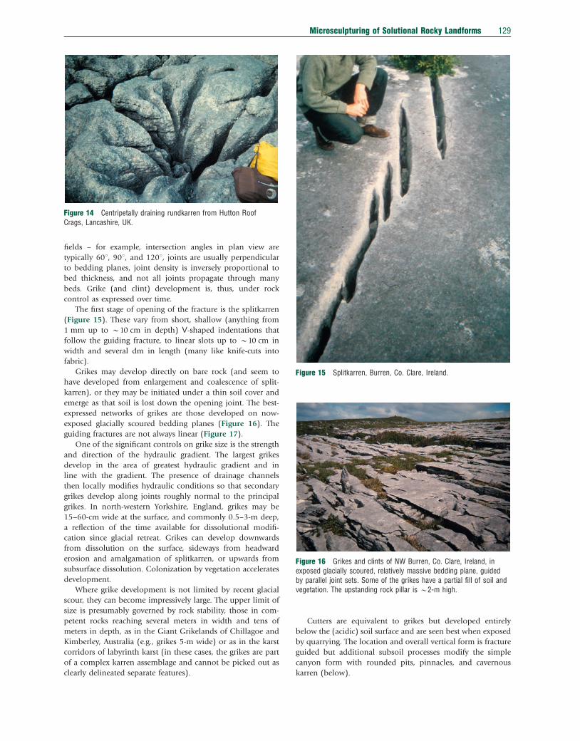
The first stage of opening of the fracture is the splitkarren
(Figure 15). These vary from short, shallow (anything from
1 mm up to B10 cm in depth) V-shaped indentations that
follow the guiding fracture, to linear slots up to B10 cm in
width and several dm in length (many like knife-cuts into
fabric).
Grikes may develop directly on bare rock (and seem to
have developed from enlargement and coalescence of split-
karren), or they may be initiated under a thin soil cover and
emerge as that soil is lost down the opening joint. The best-
expressed networks of grikes are those developed on now-
exposed glacially scoured bedding planes (Figure 16). The
guiding fractures are not always linear (Figure 17).
One of the significant controls on grike size is the strength
and direction of the hydraulic gradient. The largest grikes
develop in the area of greatest hydraulic gradient and in
line with the gradient. The presence of drainage channels
then locally modifies hydraulic conditions so that secondary
grikes develop along joints roughly normal to the principal
grikes. In north-western Yorkshire, England, grikes may be
15–60-cm wide at the surface, and commonly 0.5–3-m deep,
a reflection of the time available for dissolutional modifi-
cation since glacial retreat. Grikes can develop downwards
from dissolution on the surface, sideways from headward
erosion and amalgamation of splitkarren, or upwards from
subsurface dissolution. Colonization by vegetation accelerates
development.
Where grike development is not limited by recent glacial
scour, they can become impressively large. The upper limit of
size is presumably governed by rock stability, those in com-
petent rocks reaching several meters in width and tens of
meters in depth, as in the Giant Grikelands of Chillagoe and
Kimberley, Australia (e.g., grikes 5-m wide) or as in the karst
corridors of labyrinth karst (in these cases, the grikes are part
of a complex karren assemblage and cannot be picked out as
clearly delineated separate features).
Cutters are equivalent to grikes but developed entirely
below the (acidic) soil surface and are seen best when exposed
by quarrying. The location and overall vertical form is fracture
guided but additional subsoil processes modify the simple
canyon form with rounded pits, pinnacles, and cavernous
karren (below).
Figure 15 Splitkarren, Burren, Co. Clare, Ireland.
Figure 14 Centripetally draining rundkarren from Hutton RoofCrags, Lancashire, UK.
Figure 16 Grikes and clints of NW Burren, Co. Clare, Ireland, inexposed glacially scoured, relatively massive bedding plane, guidedby parallel joint sets. Some of the grikes have a partial fill of soil andvegetation. The upstanding rock pillar is B2-m high.
Microsculpturing of Solutional Rocky Landforms 129

The positive form left by the development of grikes is the
clint, the shape of which in plan view depends on the pattern
of guiding joints (Figure 18). With moderately thick beds and
wide joint spacing, clints are large and may harbor solution
pans. With increasing joint frequency, the clints become
smaller (and the grikes correspondingly shorter). With thinner
beds, the clints are likely to become broken up and disinte-
grate into a rubbly surface called ‘shillow’ or ‘clitter’.
6.12.2.12 Subcutaneous Karren (Bodenkarren)
Dissolution underneath a cover (usually of acidic soil, but it
can be of sediment or organic material – hence the advantage
of using the general term ‘subcutaneous’ in favor of ‘subsoil’)
gives a fundamentally different control compared with dis-
solution on a bare-rock surface. Obvious differences are the
continuous wet conditions, the maintenance of wetness over
the whole rock surface, the capillary forces that govern flow
between cover and rock, and the absence of open sheet or
channel flow. Dissolution under a cover can be several times
higher than on an open surface – partly because there is more
time of contact for reactions, but mainly because biogenic
acidification of solvent can be magnified (this is extreme
under hot, humid tropical climates – see Folk et al. (1973)).
Morphology is still governed by gravity (water still tends to
flow downwards) and lithological factors (fractures still tend
to govern location of maximum dissolution) but all the re-
sultant forms are modified by the subcutaneous conditions.
The simplest difference between subaerial and subcutaneous
dissolution is apparent from the smooth cuspate, arcuate, and
roundly runneled surfaces exposed by recent soil erosion in
contrast to the more selectively corroded, angular, sharply
etched subaerial surfaces. The result of dissolution by perco-
lation water depends on how the flow impinges on the rock,
and on the hydraulic gradient. Percolation water moving as a
sheet along the contact of high-angle rock and soil creates
smooth undulating surfaces, and sometimes subsoil ripples
(Figure 19). More focused percolation moves in channels
to create rundkarren. More diffuse percolation and a lower
hydraulic gradient produces cavernous karren.
6.12.2.13 Karren Wells
Karren wells are shafts in the epikarst that connect to small
caves, and form typically where several rundkarren merge
(Figure 20). They vary greatly in size and, although commonly
vertical, can be inclined. These are generally produced at the
junction of two or more joints, but sometimes by over-
deepening of kamenitzas to intersect the underlying bedding
planes. They may form on bare surfaces but are more likely
formed under soil (and exposed by soil erosion).
Figure 17 Curved grikes and complex clints on stromatoliticdolostones of Grand Rapids, Manitoba, Canada.
Figure 18 The jointing pattern on Hutton Roof Crags, Lancashire,UK, creates diamond-shaped clints on the 451 dipping slope (the clintsurfaces are decorated with rinnenkarren).
130 Microsculpturing of Solutional Rocky Landforms

6.12.2.14 Cavernous Karren/Subsoil Pits (KavernosenKarren)
Less-focused percolation produces a generalized rounded pit-
ting called ‘cavernous karren’ that sometimes makes a kind of
bone yard or spongework of interconnecting pits. (When
emergent, these forms may be confused with tafoni of surface
alveolar weathering.) Where percolation waters sit on a flat
surface they may carve rounded basins (‘subsoil cups’ or
‘covered kamenitzas’).
Some of the subcutaneous features are similar, and prob-
ably form in a similar manner, to cave paragenetic features,
when sediment forces flow against the rock face. On rock
faces, small anastomizing networks develop. Features of
paragenesis can also develop on underhangs, including para-
genetic-like pendants or scallops, and subsoil notches.
The relative relief in subcutaneous karren gets more ex-
aggerated the higher the acidity, gentle cusps giving way to
deep runnels and pipes in the most acid conditions. Although
subcutaneous corrosion can attack the rock from many dir-
ections, vertical downcutting of the joints is still most likely,
creating cutters and leaving interjoint positive forms that are
commonly rounded pinnacles (Figure 21).
6.12.2.15 Solution Notches (Korrosionskehlen) andSubcutaneous Half-Bells
Corrosion notches (Figure 22) form where aggressive water or
an acidic soil lies in contact with an emergent cliff face. The
upper edge is sharp but the lower edge rounded and the form
is unrelated to bedding plane corrosion. Some may be
only shallow horizontal recesses, but some swamp notches are
extremely deep – for example, the notches from valley-bottom
Figure 19 Subsoil ripples on side of an emergent block, Chillagoe,Australia. The line demarcating the former soil level is clear, the rockabove sharply etched and below smooth.
Figure 20 Vertical rundkarren around a deep karren well thatconnects into a cave system, Yorkshire, UK.
Figure 21 Rounded subcutaneous karren and cutter emergent froma terra rossa cover, exposed in a road cut, Istria, Croatia. Theemergent forms are rounded pinnacles.
Microsculpturing of Solutional Rocky Landforms 131

wetlands in the Inuvik region of Nunavit, Canada, cut more
than 1-m deep horizontally into the dolostones, but only
about 20-cm high (Ford and Williams, 1989).
Subcutaneous half-bells are akin to solution notches. They
also form just below the surface of the soil, but they develop
from focused flow where a subaerial channel delivers water to
the soil at a rate that exceeds the normal percolation rate. The
solvent, thus, remains in the soil upper horizons, carving a
rounded grotto, wider at the top and tapering with depth.
6.12.2.16 Solution Pipes (Geologische Orgeln)
Unfortunately, some publications use the term ‘solution pipe’ as
synonymous with karren well, whereas, as the discussion below
shows, solution pipes, being essentially eogenetic and synge-
netic in origin, are fundamentally distinct from karren wells.
Solution pipes are smoothly cylindrical pipes/chimneys in
soft, poorly cemented, porous rock, such as calcarenites
(Figure 23). They are invariably vertical, regardless of sedi-
mentary dip. They vary in size but are typically 0.5-m wide
(ranging from 0.2 to 1 m) and 2–5-m deep (but can be up to
20-m deep). They can be isolated but are commonly in widely
spaced sets. They commonly have cemented rims and linings
and are filled, generally with the overlying material, perhaps
sands, perhaps terra rossa. Some pipes are filled with a
modified version of the host material, preserving ‘ghost’ im-
ages of original sedimentary structures. The most significant
feature is that solution pipes form in rocks such as young
calcarenites that have high primary porosity, are commonly
quite heterogeneous, and have not undergone significant
diagenesis. Pipe formation is syngenetic in that it occurs by
concurrent dissolution and precipitation, at the same time as
sediment is being cemented into rock. Focused vertical vadose
water percolating through the porous sediments dissolves
calcareous material and then reprecipitates it at the pipe edge
to form the linings and rims.
6.12.2.17 Spitzkarren
Spitzkarren are small to medium sized, pointed, and vaguely
horn-shaped or pyramidal remnant features. There is no
unique mechanism for formation. On bare rock, they may
result from backcutting of several sets of rillenkarren around
a boss leaving a spike. Under a vegetation cover, they may be
carved by biokarstic pitting of the surrounding surfaces. Some
of the spikiest spitzkarren is produced by biokarstic processes
in low-lying swampy environments on eogenetic rock. The
spikiness is partly from the irregular biological action, but also
from the inhomogeneous rock. If it is clearly of biokarstic
origin, then spitzkarren is generally called by the general term
for karren carved by action of plants – ‘phytokarren’. In the
example shown in Figure 24, the spikes are the result of en-
hanced dissolution from mixed salt–fresh water (sea spray and
rain) driven by on-shore trade winds.
6.12.2.18 Pinnacles
Pinnacles are also spiky pointed features, but at a much larger
scale (e.g., the pinnacles of Mulu may be 50-m high) and of
more complex origin. Pinnacles are the residual positive forms
left after downcutting of grikes, cutters, and subcutaneous
runnels. They may themselves have clusters of smaller spitz-
karren on top, as well as rinnenkarren and wandkarren on the
sides (Figure 25). Pinnacles have a complex history of at least
two stages of development, the first as rounded subcutaneous
forms and the second as emergent subaerially sharpened
forms (Figure 26). To some extent, the very process of dis-
solution of grikes itself causes the downward migration of the
soil surface and the emergence of the positive forms. However,
the tallest pinnacles are associated with uplift or lowering of
base level. The largest pinnacles are in thickly bedded, mas-
sive, strong, chemically pure rocks with well-spaced joints.
6.12.3 Karren Assemblages
The account above may give the impression that karren can be
neatly categorized and described. In reality, the features are
commonly very complex, many of them polygenetic in origin.
At the landscape scale, they may be part of a large area of bare
Figure 22 Corrosion notch at the foot of a formerly subsoil pinnacle(left of the person’s foot), which itself shows the emergentrundkarren now sharpened by subaerial corrosion, New Zealand.
Figure 23 Solution pipes in coarse-grained poorly lithified beachdeposits Punta Higuero, Puerto Rico, exposed by cliff fall. Twogenerations of pipes can be seen (lying on their sides, the biggerones highlighted with white arrows), each created as the overlyingmaterial was being deposited.
132 Microsculpturing of Solutional Rocky Landforms

rock with assemblages of karren of many types, called kar-
renfields. Although the variety of individual karren features
displayed in any one karrenfield may appear to be over-
whelming, in reality certain features tend to occur together in
assemblages. These are only briefly discussed below, being
further developed in other sections of this volume.
Karrenfields developed on laterally scoured bedding planes
that have been dissolutionally modified into clints and grikes
are called pavements (Williams, 1960; Figures 10 and 16). The
lateral scour is most commonly caused by glacial action but
any mechanism such as rapid lateral retreat of slopes may
leave behind a pavement (examples of this can be seen in
Chillagoe, Queensland, Australia). Suites of pavements on
several bedding planes, separated by scarps, usually fit into
two basic types depending on relationship of topographic
slope and regional dip. This may be in cuestas or in steps
(the German terms for these – Shichtreppenkarst and
Schichtrippenkarst, respectively – being unfortunately similar
and confusable). Pavements from glacial scour are best de-
veloped where stratal dip is oriented in the direction of ice
movement. The karren of pavements include clints, grikes,
rillenkarren, rinnenkarren, karren wells, and trittkarren.
The overall structure of the clints and grikes reflects the
overall geological structure, the patterns of tension, fractures,
etc. Some of the grikes on the outer edges of scarps may be
caused by pressure release. If glacial scour was not complete,
some may inherit preglacial karstification.
Recent studies of the pavements of England and Ireland
(Gines et al., 2009) suggest that some are more polygenetic
than expected. Many are partly exhumed paleokarsts that have
resisted glacial scour, especially on the inner edges of scars
(Figure 27).
The end product of pavement development may be a
generally degraded surface of rock rubble and vegetation
patches. If grikes enlarge with minimal modification of the
clint, then the end result is a ‘ruiniform’ karrenfield of
weathered stacks (Figure 28). The ruiniform landscape of
the Venetian Prealps has been called ‘Rock Cities’; in this
case, the clint surface is made up of cherty nodular impure
micritic limestone that is resistant to dissolution. The less-
resistant underlying beds lead to development of mushroom
forms.
Some of the most spectacular karrenfields in the world
are towers or dissected plateaus, made up of pinnacles, giant
grikes, kamenitzas, and other karren. These are treated in
detail by Knez (see Chapter 6.13).
The karren fields of the west coast of Patagonia, Chile are
unique because the forms are dominated by the extraordinarily
Figure 24 Spitzkarren on eogenetic limestone of Bonaire,Netherlands Antilles. Here, the spikes are angled in the direction ofthe prevailing wind and carved by the enhanced aggressivity of mixedsea spray and rain, driven by strong winds.
Figure 25 A small outcrop of pinnacle karst, Laguna Guaniguilla,Puerto Rico. The field of view is about 2-m high.
Microsculpturing of Solutional Rocky Landforms 133

high rainfall and extreme windiness (Gines et al., 2009).
These are the best examples in the world of hydro-aeolian
dissolution and new forms are being found on every exped-
ition. Everything here is magnified – the rinnenkarren and
wandkarren are giant, 100–300-m high, some canyon-like
forms 4–8-m deep and 1-m wide; the meanderkarren have
amplitudes of several meters; and overall postglacial surface
lowering is 80–170 cm. The force of the wind often overrides
gravity, creating wind-oriented forms rather than gravito-
morphic forms. In the case of Patagonia, the obstacle marks
that develop on the lee side of protruberences (elongate
wedges dubbed ‘Rock Comets’, essentially crag and tail fea-
tures similar to the Lame Dentates mentioned above, but on
horizontal slopes rather than vertical) are decimeters in size.
Figure 29 shows tiny wind-oriented obstacle marks developed
in a very different situation, on dolostones of Dodo region in
subarctic Canada.
Another type of karren assemblage is the nival karrenfield.
These occur in arctic and alpine regions with significant
winter snow cover. Trittkarren, trichterkarren, and sharpened
edges have been taken as diagnostic of dissolution under
a snow cover. They certainly are more common in areas of
snow, but the presence of similar forms in wet and windy
but non-snowy environments does rather give the lie to this
assertion.
Figure 26 Rounded pinnacles emergent from under a soil cover, WeeJasper, Australia. The surfaces more recently soil covered are stillsmooth, those less recently covered have been sharpened byrillenkarren (Australia has some of the biggest rillenkarren in the world).
Figure 27 Scar Close, Yorkshire. The inner edge of the pavementstill shows the circular solution pipes (each circular depression isabout 1 m in diameter) of the partly glacially truncated paleokarst.The outer part of the pavement has more normal rectangular clintsand grikes.
Figure 28 Example from Scar Close, Lancashire of pavementdegraded into the beginning of a ruiniform landscape. The wallsexposed above the soil are up to B1-m high.
Figure 29 Tiny wind-oriented obstacle marks in dolostones of theDodo region, subarctic Canada (lens filter is 5 cm in diameter).
134 Microsculpturing of Solutional Rocky Landforms

6.12.4 Classification
Classification is challenging because of the great number of
forms, many of which are gradational to other forms and
of various sizes. Also, challenging is the great variety of
terminologies from different studies, in different languages,
for forms that may turn out to be identical. The simplest
classification is by morphometry and size – but that is only
descriptive and has only moderate genetic implication. Clas-
sification by genetic factors is preferable but prone to error if
the genetic mechanisms are not fully known (and inferring
process on the basis of form alone may be dangerous). So, we
are generally left with classification schemes that are partially
morphometric and partly genetic (see examples in Ford and
Lundberg (1987), Ford and Williams (1989), Fornos and
Gines (1996), and Gines et al. (2009)).
Morphometry divides features according to basic form –
circular or linear (with tacit implications about the nature and
duration of the rock-solvent contact) – and according to size –
micro, meso, macro, etc. Size depends on the dimension
chosen, so size is usually indicated based on the smallest di-
mension. Micro forms are o1 cm (e.g., rillensteine and some
pits). Small forms are 41 cm but o1 m, and include the
majority of karren forms. Large forms are 41 m (e.g., clints
and pinnacles). An indication of whether the form is negative
(erosional) or positive (remnant) is not of much value be-
cause only clints, spitzkarren and pinnacles are positive.
The most basic of genetic divisions is according to extent of
cover – bare (or ‘free’) karren, partly covered (‘half-free’), and
completely covered – again with tacit implications about
the process. Simple hydrodynamic controls are most likely
expressed on bare karren, where solvent may remain in con-
tact with rock for only a short time (‘hydrodynamic’ means the
way that fluid flows, or the forces, energy, and pressure of
liquid in motion). Bare karren is the most likely to show the
effects of microclimates (such as differential drying and varied
microbiological colonization) and, thus, most likely to show
the sharp etching of distinct differential corrosion. For covered
karren (which is generally subdivided according to nature of
cover into acidic cover – which yields karren – vs. carbonate
cover – which yields no karren), the solvent is in contact with
the whole rock surface for longer and is itself acidified by
biogenic CO2. Here, hydrodynamic controls are subdominant
to lithological and hydraulic controls.
Although the distinction between bare and covered is very
useful, it does not acknowledge explicitly the underlying,
more basic controls on the dissolution process. For this rea-
son, classification according to hydrodynamic control versus
lithological control is preferable, although it does ignore
chemical controls. Further categorization according to the
behavior of the solutional agent is useful. Adding a
polygenetic category acknowledges the generally non-simple
nature of most karren.
6.12.4.1 Classification Based on Physical and ChemicalProperties of Solvent and Solute
Dissolution can only take place where rock and solvent meet,
so the movement of that solvent is clearly an important
control (i.e., hydrodynamics). The forces, energy, and pressure
of fluid in motion includes direct raindrop impact (rillenkar-
ren and rainpits), sheet flow on a surface (solution bevels in
their various forms), and open channel flow (rinnenkarren
and variants thereof). Aeolian control is exerted here in how it
forces fluid to flow (perhaps constraining flow as a sheet when
it would normally separate into channels, or perhaps in-
hibiting free gravitational drainage). Surface tension (perhaps
augmented by rapid evaporation) may serve to hinder flow
(rillensteine).
The presence of a cover also hinders free flow. It either
forces flow to the very narrow contact zone between the cover
and the rock (subcutaneous scallops) or it forces flow to move
by percolation in the interparticle pore spaces and channels.
Percolation and capillary flow serve to keep the covered rock
surfaces in long-term contact with the solvent. A biological
cover (even on the microscopic scale) and a snow cover also
serves in this way (although the snow cover acts for only some
of the time).
The chemical properties of that solvent are the next most
important control (i.e., aggressivity). Simple rainwater has
little dissolutional potential. Modifications of the solvent in-
clude enhancement of aggressivity (e.g., by absorption of CO2,
from soil, by contact with biological material, or from snow),
or reduction of aggressivity (by contact with soluble material).
Looking at the chemical and physical properties of the
solute (the material to be dissolved) provides the third level
of control. Of the rock factors, rock chemistry is important in
that it must be soluble, or at least some part of it such as
interclast cement (which explains why nonkarst rocks such as
some sandstones may display dissolutional karren features).
The extent of lithification is important in that eogenetic rocks
dissolve perfectly well but do not develop neat karren features.
Rock homogeneity generally governs the regularity of the
karren and certain karren (mainly rillensteine) will only be
expressed on the finest-grained rocks.
The most important of the rock features is fracture control.
This is the biggest control of the largest forms because it acts
most strongly under a cover and the largest of the karrenfields
generally form initially under a cover. Thus, fracture control
governs, grikes, clints, cutters, and pinnacles.
These four main controls govern the processes of karren
formation. Obviously, other factors may be important to the
final morphology. Many are of polygenetic origin, several of
these basic controls operating at different times in different
ways. Many karren features are inherited from another land-
scapes such as glacial scour forms or paleokarst forms. The
classification scheme presented here (Figure 30) is an attempt
to present the forms with the practically useful descriptions of
form and size but also to include all the known genetic factors.
6.12.4.2 Important Karren Regions
The list of important karren regions is, of course, limited by
what has been published, what is accessible, and what has
been explored by karst geomorphologists. It is highly likely
that important karren regions in more remote regions will
come to light in future years. There is generally a bias toward
English-language reports and toward well-studied regions,
Microsculpturing of Solutional Rocky Landforms 135

(a)
(b)
Figu
re30
The
clas
sific
atio
nsc
hem
e.(a
)S
umm
ary
ofth
em
ajor
cont
rols
onka
rren
form
atio
nan
dth
esy
mbo
lsus
edto
indi
cate
each
.Th
ele
gend
expl
ains
the
sym
bols
arou
ndea
chof
the
karr
enfo
rms:
size
issh
own
byth
eco
lor
ofth
ere
ctan
gle
show
ing
the
nam
e;co
ver
byth
esq
uare
toth
ele
ftof
this
box,
rock
cond
ition
sby
the
squa
reto
the
righ
t,et
c.In
som
eca
ses,
two
sym
bols
for
the
sam
efe
atur
ear
ein
clud
edbe
caus
ebo
thar
eeq
ually
impo
rtan
t(e
.g.,
the
fluid
chem
istr
ym
ight
bebo
thst
ored
wat
eran
dbi
olog
ical
lym
odifi
edw
ater
).(b
)Th
eka
rren
form
sar
rang
edac
cord
ing
tore
latio
nshi
ps.
Thes
ear
ear
rang
edac
cord
ing
toth
em
ost
impo
rtan
tco
ntro
l.S
ome
karr
enlie
sole
lyw
ithin
one
cont
rol.
Oth
ers
have
atle
ast
two
maj
orco
ntro
ls–
indi
cate
dby
the
over
lapp
ing
colo
rs.
Of
the
hydr
odyn
amic
ally
cont
rolle
dfo
rms
(pal
ebl
ue),
thos
eim
pact
edby
snow
/ice
mel
tar
ea
clas
sto
them
selv
es(s
light
lyda
rker
blue
)bu
tw
ithin
the
hydr
odyn
amic
form
s.Th
efr
actu
re-c
ontr
olle
dfo
rms
(yel
low
)ov
erla
pw
ithth
esu
bcut
aneo
usfo
rms
(pal
eor
ange
),w
hich
them
selv
esov
erla
pw
ithth
ehy
drod
ynam
ical
lyco
ntro
lled
form
s.Th
eco
mpl
ex/p
olyg
enet
icfo
rms
(pin
k)ov
erla
pw
ithhy
drod
ynam
ical
lyco
ntro
lled
form
s.Th
em
anife
stly
biol
ogic
ally
med
iate
dfo
rms
dono
tov
erla
pw
ithan
yot
hers
.
136 Microsculpturing of Solutional Rocky Landforms

such as Europe (see Fornos and Gines, 1996; Gines et al.,
2009). For this short review, the list below cannot be
exhaustive.
The most important karren regions are always also im-
portant karst regions (e.g., the Mulu karst of Sarawak) – but
many important karst regions have poorly developed karren
(e.g., the sinkhole plain of Kentucky). In western Europe,
Ireland’s Burren and NW England have excellent clint and
grike pavements. The European Alps have many widespread
and varied suites of karren, such as central Switzerland, the
Italian Dolomites and the Austrian Dachstein, as does the
Classical Karst region of Slovenia and Croatia. In the Medi-
terranean area, the Pyrenees, and the island of Mallorca have
beautiful karrenfields. Surprisingly, some areas of extensive
tropical karst have unexceptional karren, for example, the
Caribbean islands (and this is probably governed largely by
the lithology of the young rocks), whereas others have
extremely impressive karren, such as the Tsingy regions
of Madagascar, northern Australia’s Chillagoe and Kimberley
regions, South-East Asia’s Sarawak region, Mt. Kaijende of
New Guinea, and south China’s Yunnan province. Temperate
regions with impressive karren include parts of New South
Wales, Australia, and New Zealand’s Mt. Owen and Arthur
region (Kahurangi National Park). Madre de Dios Island,
Patagonia has recently come to light as one of the more
interesting karren regions where wind is an important control
on morphology. Although most subarctic and arctic regions
do not display good karren, there are a few, such as Dodo and
Nahanni, Canada, where frost action is not dominant and
karren can still occur. Although the vast majority of karren
fields are developed on carbonate or evaporite rocks (tradi-
tionally viewed as the ‘soluble’ rocks), some sizable examples
occur on quartzites (e.g., Transvaal, South Africa) and on
sandstone (e.g., the Tepuis of Venezuela).
6.12.5 The Future
Modeling and biokarst are probably the two ‘hottest’ topics in
the field of microsculpturing of solutional rocky landforms.
Future directions for research may address some of these
questions:
• What is the connection between process and form?
• Can modeling, either physical (such as plaster block ex-
periments) or mathematical (such as computer modeling),
elucidate process?
• Can field studies be tailored to isolate environmental
controls (such as rainfall intensity vs. quantity)?
• Can the application of statistical methods improve our
understanding of significant differences?
• Can we use principles of ecology to elucidate karren–
environment relationships, and karren development?
• To what extent is organic activity an inherent process
in karren formation (i.e., in all karren and not simply
biokarst)? Can this be quantified?
• What is the explicit mechanism by which biological action
affects corrosion/denudation?
References
Bogli, A., 1951. Probleme der Karrenbildung. Geographica Helvetica 3, 191–204.Bogli, A., 1960. Kalklosung und Karrenbildung. Zeitschrift fur Geomorphologie
Supplement 2, 4–21.Bogli, A., 1980. Karst Hydrology and Physical Speleology. Springer, Berlin, 284 pp.Bogli, A., 1981. Solution of limestone and karren formation. In: Sweeting, M.M.
(Ed.), Karst Geomorphology. Benchmark Papers in Geology 59. Hutchinson RossPublishing Company, Stroudsberg, PA, pp. 64–89.
Folk, R.L., Roberts, H.H., Moore, C.H., 1973. Black phytokarst from Hell, CaymanIslands, British West Indies. Geological Society of America Bulletin 84,2351–2360.
Ford, D.C., Lundberg, J., 1987. A review of dissolutional rills in limestone andother soluble rocks. Catena Supplement 8, 119–140.
Ford, D.C., Williams, P., 1989. Karst Geomorphology and Hydrology. Unwin Hyman,London, 601 pp.
Fornos, J.J., Gines, A. (Eds.), 1996. Karren Landforms. Servei de Publicacions,Universitat de les Illes Balears, Palma de Mallorca, 450 pp.
Gines, A., 2004. Karren. In: Gunn, J. (Ed.), Encyclopedia of Caves and KarstScience. Fitzroy Dearborn, New York, NY and London, pp. 470–473.
Gines, A., Knez, M., Slabe, T., Dreybrodt, W. (Eds.), 2009. Karst Rock FeaturesKarren Sculpturing. Carstologia 9, Zalozba ZRC/ZRC Publishing, Ljubljana,pp. 562.
Glew, J.R., Ford, D.C., 1980. A simulation study of the development of rillenkarren.Earth Surface Processes and Landforms 5, 25–36.
Jakucs, L., 1977. Morphogenetics of Karst Regions. Adam Hilger, Bristol, 284 pp.Jennings, J.N., 1985. Karst Geomorphology. Basil Blackwell, Oxford.Sweeting, M.M., 1972. Karst Landforms. Macmillan, London.Trudgill, S.T., 1985. Limestone Geomorphology. Longman, London and New York,
NY, 196 pp.White, W.B., 1988. Geomorphology and Hydrology of Carbonate Terrains. Oxford
University Press, Oxford.Williams, P.W., 1960. Limestone Pavements. Transactions of the Institute of British
Geographers 40, 155–172.
Relevant Websites
http://www.doc.govt.nzDepartment of Conservation; Natural sites of high priority for immediate WorldHeritage listing.
http://www.fotopedia.comfotopedia; Ankarana Reserve; South China Karst.
http://www.gsi.ieGeological Survey of Ireland; The Karst of Ireland.
http://www.ijs.speleo.itInternational Journal of Speleology; IJS Photo Gallery.
http://www.limestone-pavements.org.ukLimestone Pavement Conservation.
http://www.limestone-pavements.org.ukLimestone Pavement Conservation; Geology.
http://bioref.lastdragon.org/habitats/LimestonePavement.htmlLimestone Pavement; Images of British & Irish biodiversity.
http://www.malaysiasite.nlMALAYSIA; The Pinnacles: the famous Pinnacles of Mulu National Park.
http://www.world-heritage-tour.orgPatrimonium-mundi.org: UNESCO world heritage site in panophotographiesimmersive and interactive panoramic images; Earth; Asia, China.
http://science.jrank.orgScience Encyclopedia; Karren.
http://www.ee.usyd.edu.auThe University of Sydney: Electrical and Information Engineering; SydneyUniversity Speleological Society.
http://www.travel-images.comTravel Images: The Global Image Bank; Images of Madagascar.
http://zuzutop.comzuzu.com; The Fascinating Stone Forest on Madagascar.
Microsculpturing of Solutional Rocky Landforms 137

Biographical Sketch
Joyce Lundberg was educated in Trinity College, Dublin, Australia National University, Canberra (MSc), Bristol
University (PGCE), and McMaster University, Hamilton (PhD). After a short career teaching high school biology,
music, and art in England and Kenya, she joined the faculty of Carleton University in 1990. Her research interests
include field-based studies and lab-based (mainly geochronology) studies of karst geomorphology (both arctic
and tropical), speleology, cave paleontology, sea-level change, and paleoclimatology. Of late, she has become
interested in zoogeomorphology in caves.
138 Microsculpturing of Solutional Rocky Landforms