Embed Size (px)
Citation preview
Late Bronze Age and Early IronAge settlement and boundariesAlthough numerous, the monuments of theMiddle Bronze Age and earlier, discussed inthe previous chapters, represent a very smallproportion of the cropmarked and soilmarkfeatures mapped by the project. Themajority of cropmarks and soilmarks, and ahandful of surviving earthworks, areprobably the remains of settlements datingfrom the Late Bronze Age to the Romanperiod. However, as most are undated, thisevidence may include a proportion of so farunrecognised earlier or later features.
After the increasingly prolific monumentbuilding of the Neolithic and Early toMiddle Bronze Age, the Late Bronze Ageappears to signal a return to relatively lowlevels of archaeological visibility, from theair as well as on the ground. Ritual orfunereal landscapes, which dominate ourknowledge of earlier periods, are known inthe Middle and Late Bronze Age only fromthe chance discovery of a few cremationcemeteries (Chapman 1999, 7). As with theearlier periods, Late Bronze Age and EarlyIron Age settlement evidence is sparse,relatively ephemeral and, at favoured sites,often overwhelmed by the more abundantcropmarks of later activity. Nevertheless it ispossible that some elements of Late BronzeAge and Early Iron Age landscapes can befound among the wealth apparently latercropmarks recorded in the project.
Open settlement
The project has generated a significant,although undoubtedly very incomplete,record of later prehistoric open settlement inNorthamptonshire. This contrasts with theexperience of other Midlands NMP projects,which have reported an absence of any airphoto evidence of unenclosed round houses(Winton 1998, 53; Deegan 1999, 41).During reconnaissance it can be very difficultto detect ephemeral settlement remains that
are not enclosed or associated with moresubstantial ditches, and so unenclosedsettlement is probably under-represented inthe aerial photographic record for the county.
The excavation record for Late BronzeAge and Early Iron Age open settlement inNorthamptonshire is slim, but does indicateconsiderable diversity. The site at GreatOakley consisted of just two huts or shelters ofprobable Early Iron Age date, which werepossibly associated with nearby iron smelting(Jackson 1982). In contrast, Early and MiddleIron Age open settlements at Crick developedinto extensive and long-lived sites: Long Doleand Crick Covert were subsequently enclosed,but the settlement at the Lodge remainedunenclosed into the Late Iron Age (Chapman1995). On Rainsborough Hill, Newbottle,sparse remains of an open settlement werefound on the site of a later hillfort (Avery et al1967). None of these examples of Early IronAge open settlement, or others excavated atWeekley Hall Wood and Wilby Way, had beenrecorded from the air.
Almost all of the round houses identifiedby the project are represented by circular orsub-circular gullies, and very few post-defined structures have been identifiedwhere gullies are not also present. Based onthe excavated evidence, Jackson suggestedthat the gullied form, although possiblyinfluenced by geological conditions, was‘rarely found before the Middle Iron Age’(1979b, 14). If Jackson is correct, then theEarly Iron Age house is largelyunrepresented in the air photographic recordfor the county and, while some of the manyMiddle to Late Iron Age open settlementshad earlier origins, it is probably a veryincomplete record of Late Bronze Age andEarly Iron Age open settlement as a whole.
Late Bronze Age and Early IronAge hillforts
The earliest defended sites are the small, LateBronze Age ringwork at Thrapston, whichcovers less than 1ha, and the large, undated,
81
6Late Bronze Age, Iron Age and
Roman settlements and landscapesby Alison Deegan
contour fort at Borough Hill, Daventry,which encloses some 52ha (Jackson 1996–7,152; Hull 2001). The small, sub-rectangular,defended enclosure at Thenford may also beearly, as may the initial defences at Hunsburyand Rainsborough, Arbury Camp (alsoknown as Arbury Banks) at ChippingWarden, and Arbury Hill, Badby (Jackson1993–4, 16–20; Kidd 1999, 20). RCHMEdismissed the latter as a natural feature, butthe archaeological interpretation was recentlyrevived by Kidd (RCHME 1981, 8–9; Kidd1999, 20). Kidd also suggested that the large,undated curvilinear enclosure on WardenHill, Chipping Warden, was an Iron Agehillfort (1999, 20. Field-walking in this areahas not retrieved any Iron Age material but asubstantial Neolithic flint scatter wasrecovered from a neighbouring field (D Hallpers comm.). It is suggested here that theenclosure was built in the Neolithic, but thetrackway or boundary that skirts the inside ofthe enclosure is probably of later date (seeChapter 4, Fig 4.2: 5).
Land boundaries andcommunications
The earliest known ditched land divisionscome from excavations on the floor of theNene Valley. At Grendon a smallarrangement of ditches may have predated adouble-ditched ring ditch of probableBronze Age date, and at Stanwick andRaunds the 2nd-millenium stock-controlgullies, ditches and trackways appear to havebeen planned with reference to the existingBronze Age monuments (Jackson 1997, 5;Healy et al 2007, 191–6). At Wollaston,extensive open-area investigations haveunravelled the development of land divisiondefined by pit alignments, and ditches andfarmsteads, which were first identifiedthrough aerial reconnaissance (Meadows1995, 44). Here the valley floor appears to have been cleared of woodland during the Bronze Age, then maintained as open grassland, and ultimately divided upinto large rectangular blocks of land. The earliest boundaries were demarcated by pit alignments, many of which weresubsequently re-defined by ditches. Thisframework persisted through the Iron Age,when small, enclosed farmsteads were builtat the corners of the land parcels; some ofthese settlements, or their successors, werestill occupied in the Roman period.
The most striking feature, known fromexcavated and aerial data, is a pit alignment
that runs along the valley for more than 2km(Fig 6.1), parallel to, and approximately550m south east of a tributary of the Nene,together with traces of a second parallelalignment 230m farther south-east, at theedge of the valley floor. A series of shorterboundaries traverse the valley floor, from itsedge to the tributary, intersecting the mainpit alignment at right angles. Together thesedivide the valley floor into relatively regularrectangular blocks, suggesting a significantelement of planning. There are other pitalignments that run diagonally across theorientation of the main alignment, whichmay relate to an earlier and abandonedphase of land division, as they are notrespected by the later settlement enclosures.
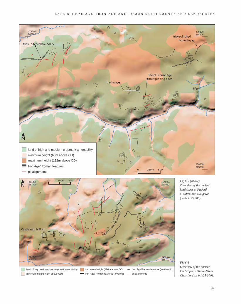
Pit alignments occur in many other partsof the county (see Panel 1 and Fig 6.2).Some of these pit alignments are arranged incoherent rectilinear systems, often associatedwith single and double-ditched boundaries,which are similar to the orderly land divisionseen at Wollaston. The most extensive andcoherent examples are in the south-west ofthe county, at Newbottle (Fig 6.3); to thenorth of Northampton, in the parishes ofHarlestone, Church Brampton and ChapelBrampton, and near by in Pitsford, Moultonand Boughton (Figs 6.4 and 6.5); Stowe-Nine-Churches (Fig 6.6) and at Ketton inRutland (Fig 6.7). Inevitably the cropmarksdisappear as they cross onto the lesspermeable geologies, and, as the geology ofthe county can change significantly overshort distances, most of our evidence forthese landscapes is regrettably disjointed.However, the distribution of long lengths ofsingle pit alignments in between thesefragmentary arrangement hints that thelandscapes defined by pit alignments werefar more extensive and represent a dramaticphase of land division in late Bronze Ageand/or Early Iron Age Northamptonshire(see Fig 6.2).
This phase of landscape developmentextended into some, but probably not all,areas of poorer agricultural land on the lesspermeable geologies. Evidence for pitalignments is absent from the boulder-clay-capped plateaux of Rockingham Forest andthe Nene–Ouse watershed. Thoughcropmarks do show surprisingly well on thelatter, experience, particularly fromreconnaissance, would suggest that thedefinition of the cropmarks there isgenerally insufficient to distinguish chains ofpits from continuous ditches. There are pitalignments on the clays of the Nene–Avon
M A P P I N G A N C I E N T L A N D S C A P E S I N N O RT H A M P T O N S H I R E
82
Fig 6.1 (opposite)Schematised and simplifiedoverview of the air photo,geophysical survey andexcavation evidence of theancient landscapes atWollaston (geophysicalsurvey and excavationevidence reproduced with thekind permission of North-amptonshire Archaeology)(scale 1:15 000).
L AT E B R O N Z E A G E , I R O N A G E A N D R O M A N S E T T L E M E N T S A N D L A N D S C A P E S
83
N
0 150m 300
land below 50m OD
land 51-60m
land 61-70m
land 71-80m
land 81-90m
palaeochannel
area of geophysical survey
limits of excavation
excavated feature
geophysical anomaly
cropmark/soilmark feature
cropmark/soilmark pit alignment
excavated pit alignment
River Nene
488000,262000
490300,262000
490300,265200
510000,305000
450000,305000
450000,230000
510000,230000
N
2
1
3
4
5
6
8
9
7
10
11
undated or later hillfort
land of high and medium cropmark amenability in Northamptonshire
parallel or perpendicular arrangement of pit alignments
other single pit alignments
hillfort with possible LBA-EIA origins
hillfort with possible LBA-EIA origins
0 5km 10
Fig 6. 3
Fig 6. 5
Fig 6.4
Fig 6.5
Fig 6. 7
Fig 6.1
M A P P I N G A N C I E N T L A N D S C A P E S I N N O RT H A M P T O N S H I R E
84
Fig 6.2 Distribution of pit alignments and known and possible hillforts: 1 Newbottle (Rainsborough); 2 Thenford; 3 Chipping Warden (Arbury Banks or Camp); 4 Badby (Arbury Hill); 5 Farthingstone(Castle Yard); 6 Daventry (Borough Hill); 7 Guilsborough; 8 Northampton (Hunsbury); 9 Hartwell (Egg Rings); 10 Irthlingborough (Crow Hill); 11 Thrapston) (scale 1:400 000).
Fig 6.3 (opposite)Overview of the ancient landscapesat Newbottle and environs andviewshed from Rainsborough hillfort(scale 1:25 000).
L AT E B R O N Z E A G E , I R O N A G E A N D R O M A N S E T T L E M E N T S A N D L A N D S C A P E S
85
land
vis
ible
from
hill
fort
min
imum
hei
ght (
90m
abo
ve O
D)
max
imum
hei
ght (
172m
abo
ve O
D)
built
or
quar
ried
land
Iron
Age
/ Rom
an fe
atur
es
mod
ern
paris
h bo
unda
ry
pit a
lignm
ents
N
4572
00,
2343
00
4520
00,
2342
00
4520
00,
2383
00
02
50
m5
00
fun
nel
led
en
tran
ce
larg
e ov
al e
ncl
osu
re
sett
lem
ent
site
of C
rou
gh
ton
Ro
man
vill
a
Rai
nsb
oro
ug
h
hill
fort
site
of
op
en s
ettl
emen
t
larg
e p
it c
lust
er
watershed at Naseby, while excavations atCrick revealed other clayland examples,suggesting that pit alignment land divisionsmay well have extended onto the highestground in the north-west of the county(Kidd 1999, 5). Long pit alignments are
also largely absent from the basin drained bythe River Tove, although here it may bebecause the areas of permeable geology arewidely dispersed among heavier soils.
A significant element in the prehistoriclandscapes at Stowe-Nine-Churches, the
M A P P I N G A N C I E N T L A N D S C A P E S I N N O RT H A M P T O N S H I R E
86
Nland of high and medium cropmark amenability
minimum height (52m above OD)
maximum height (163m above OD)
Iron Age/ Roman features
pit alignments
469400,262400
473400,262400
funnelled entrance?
trackway
473400,266900
0 250m 500
triple-ditched boundary
Fig 6.4 Overview of the ancientlandscapes at Harlestone,Church Brampton andChapel Brampton (scale 1:25 000).
L AT E B R O N Z E A G E , I R O N A G E A N D R O M A N S E T T L E M E N T S A N D L A N D S C A P E S
87
land of high and medium cropmark amenability
minimum height (60m above OD)
maximum height (132m above OD)
Iron Age/ Roman features
pit alignments
474200,268200
478200,268200
478200,265200
N
site of Bronze Age multiple ring ditch
0 250m 500
triple-ditched boundary
triple-ditched boundary
trackway
N461300,257400
464500,257400
461300,255700
464500,255700
Castle Yard hillfort
0 250m 500
triple-d
itche
d bo
unda
ry
land of high and medium cropmark amenability
minimum height (63m above OD)
maximum height (180m above OD)
Iron Age/ Roman features (levelled)
Iron Age/Roman features (earthwork)
pit alignments
Fig 6.5 (above)Overview of the ancientlandscapes at Pitsford,Moulton and Boughton(scale 1:25 000).
Fig 6.6 Overview of the ancientlandscapes at Stowe-Nine-Churches (scale 1:25 000).
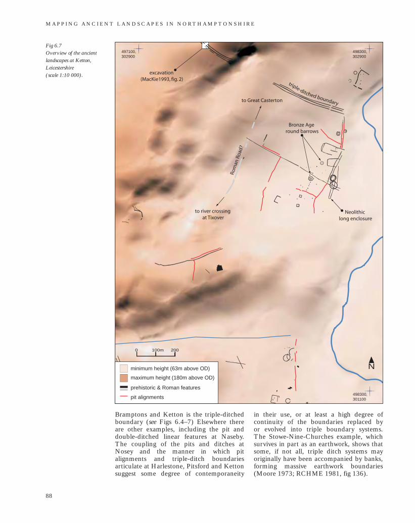
Bramptons and Ketton is the triple-ditchedboundary (see Figs 6.4–7) Elsewhere thereare other examples, including the pit anddouble-ditched linear features at Naseby.The coupling of the pits and ditches atNosey and the manner in which pitalignments and triple-ditch boundariesarticulate at Harlestone, Pitsford and Kettonsuggest some degree of contemporaneity
in their use, or at least a high degree ofcontinuity of the boundaries replaced by or evolved into triple boundary systems. The Stowe-Nine-Churches example, whichsurvives in part as an earthwork, shows thatsome, if not all, triple ditch systems mayoriginally have been accompanied by banks,forming massive earthwork boundaries(Moore 1973; RCHME 1981, fig 136).
M A P P I N G A N C I E N T L A N D S C A P E S I N N O RT H A M P T O N S H I R E
88
Fig 6.7 Overview of the ancientlandscapes at Ketton,Leicestershire (scale 1:10 000).
N
498300,301100
498300,302900
497100,301100
497100,302900
0 100m 200
excavation (MacKie1993, fig. 2)
Bronze Age round barrows
Neolithic long enclosure
Rom
an R
oad?
minimum height (63m above OD)
maximum height (180m above OD)
prehistoric & Roman features
pit alignments
to river crossing at Tixover
to Great Casterton
triple-ditched boundary
Pit alignments yield little dateableevidence. For example, the Wollaston pitalignments were initially dated on theevidence of a single sherd of Early Iron Agepottery although they were alsodemonstrably earlier than the WollastonMiddle to Late Iron Age farms (Meadows1995, 44). However, sufficient absolute andrelative dates are now available fromexcavated sites to suggest that the regular,oblong pits that form most of the cropmarkalignments probably date from the LateBronze Age or Early Iron Age (see Panel 1).
Multi-bank and ditch boundaries alsotend to lack dating evidence. Although sitesin other counties have produced varieddates, a Late Bronze Age to Middle IronAge date is suggested by excavations at theKetton (Mackie 1993, 7; Boutwood 1998,38–9). The function or symbolism of theseboundaries, and the pit alignments inparticular, is still much debated (forexample Wilson 1978; MPP 1989; Pollard1996; Waddington 1997; Thomas 2003).However from the Northamptonshireevidence it may be reasonable to concludethat, in this region at least, such boundarieswere part of a large-scale and planneddivision of land initiated during the LateBronze Age or Early Iron Age, of which only small, disjointed fragments are visiblefrom the air.
Discussion
The evidence from Wollaston indicates thatthe pit-defined boundaries were built in alandscape that had been cleared in theBronze Age and subsequently maintained asgrassland. Interestingly, no Neolithic orBronze Age monuments were reported inthe area, but there was tentative evidence forsome Neolithic activity (Meadows 1995);Kidd has also remarked on the absence ofLate Bronze Age and Early Iron Agesettlement evidence from the Wollaston area(1999, 5). However, at Ketton the sites ofprobable Bronze Age round barrows arefound on land divided by pit alignments andditches, although interestingly the possibleNeolithic long enclosure may have beendeliberately avoided by some boundaries(see Fig 6.7). At Pitsford a pit alignment wascut through the centre of a possible multi-ditched barrow (see Fig 6.5).
The Early Iron Age open settlement atGreat Oakley, Corby, was sited on boulderclay in the Rockingham Forest area,apparently well beyond any known area of
planned landscape (Jackson 1982). Incontrast, at Weekley Hall Wood, opensettlement lay within an area that at sometime was divided by a near-parallelarrangement of boundaries. These landdivisions consisted of a north–south alignedLate Bronze Age or Early Iron Age double-ditched linear boundary and, 200–300m tothe north-east, a pit alignment. The pitalignment was also associated with aperpendicular ditch. Early Iron Agesettlement remains were found near boththe double-ditched linear and the area of thepit alignment (Jackson 1976b). The pitalignment was not securely dated, andalthough some pits produced Early Iron Agepottery the excavator, using comparisonsfrom other counties, favoured a later date.
The settlement and later hillfort atRainsborough, Newbottle, were situatedwithin an extensive landscape of long, linearboundaries (see Fig 6.3), which hints at aplanned layout of regular rectilinear blocks,although central to the area is a large sub-oval enclosure defined by single and doubleditches. This large enclosure encompasses a small valley and appears to have beenentered through a broad funnelling trackwayor drove road to the north-east, where theland is highest. Other boundaries of morerectilinear form radiate from the circuit of this enclosure, suggesting that it predates their imposition. It may be highlysignificant that part of the enclosure circuitis followed by the parish boundary (seechapter 7). There has been relatively little modern development in this area and,as a consequence, few excavations, so none of the elements of this landscape havebeen dated except the hillfort and the earlieropen settlement. Although on currentcropmark evidence it appears that the site of the hillfort was slightly peripheral to this system, it did have a good commandover this landscape and, in particular, a full view of the large curvilinear enclosure (see Fig 6.3).
The photographic evidence for the large funnel-entranced enclosure was slowly gathered through years of repeatreconnaissance in this area. It is possiblethat there are other examples in the countythat are either are unrecognised so far, ortoo poorly understood; the convergence ofthe multi-ditch boundary and trackway on atributary of the Nene at Harlestone may beone such example (see Fig 6.4), andfragmentary evidence of another funnelledentrance, later largely filled by settlement,
L AT E B R O N Z E A G E , I R O N A G E A N D R O M A N S E T T L E M E N T S A N D L A N D S C A P E S
89
may exist at Chapel Brampton (see Fig 6.12:5). Other possible examples have beententatively identified, not from aerial data,but rather fossilised in later medieval andpost-medieval landscapes. This is a themesubject to ongoing research (see Chapter 7and Foard et al 2005, 25).
For the most part, there is no tangiblerelationship between the known hillforts andthe planned landscapes. Castle Yard is againseemingly peripheral to a well-demarcatedsystem of pit alignments and otherboundaries; the sequence of development isunknown, but, as the hillfort is dated to theMiddle Iron Age, it is possible that it wasbuilt sometime after these divisions werefirst laid down. The hillfort’s rectilinear planmay reflect a pre-existing rectilinear patternof land division (see Fig 6.6). The rectilinearplan of other hillforts, such as Irthling-borough and Guilsborough, may also proveto have originated in this way.
The evidence from excavations alonemay imply that the Late Bronze Age andEarly Iron Age population was very low andwidely dispersed. The NorthamptonshireNMP does not contradict this with evidenceof hitherto unsuspected settlements, butdoes suggest a population of sufficient sizeand level of organisation to take into handlarge tracts of land. The population maywell have been low but still mobile, perhapsengaged largely in pastoral, rather thanarable, farming.
Rural settlement in theMiddle to Late Iron Age andRoman period
Open settlement
Based on Jackson’s observation that mostring-gullied huts were built in the MiddleIron Age or later, most such housesrecorded by the project are attributed tothese periods. The construction of post-built houses did continue throughout theIron Age; remains of this type have beenfound preserved under villas atDeanshanger, and Alderstone Field, Ashley,but they were not visible on the airphotographs consulted. (RCHME 1982,41; Taylor and Dix 1985).
Hundreds of hut circles have beenrecorded from air photographs, but because it is difficult to identify opensettlement among the cropmarks of
complex multi-period landscapes, manymore are likely to have gone unseen orunrecognised. The enclosure of previouslyopen sites, or the expansion of settlementsbeyond their earlier bounds, creates aparticular problem when the chronologicaldetails are unknown.
The small settlement at Wakerleyconsisted of a sequence of huts, up to sevenin total, arranged to the north of a largepolygonal enclosure (Jackson and Ambrose1978, fig 4). In a later phase the area of thehuts was enclosed by a massive ditch, butthe excavators suggest that by that timeperhaps only one was in use, and that thiswas abandoned soon afterwards (Jacksonand Ambrose 1978, 124; cf Gwilt 1997,163–4). Similarly, at Twywell one or twostructures were built within a palisadedenclosure; the palisade was later replaced bya ditch, but subsequent settlementdeveloped outside the confines of theenclosure (Jackson 1975).
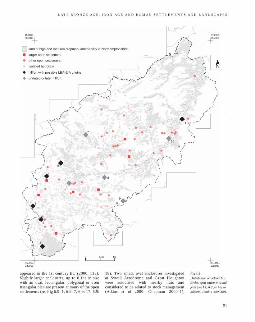
The project has revealed a dispersedpattern of single hut circles, but again this isundoubtedly incomplete (Fig 6.8). Somemay be the mistaken ring ditches of roundbarrows; others may be the only visibleindications of larger unseen settlements, butDawson has noted similar singular sites inthe Ouse Valley, such as Biddenham, whichco-existed with the larger open settlements(2000, 115). The Northamptonshireexamples are scattered throughout most ofthe county, although they appear to beabsent north-east of Harpers Brook and inthe area between the Nene–Avon watershedand the River Avon; both are areas wherecropmarked sites are fewer and sparser (seechapter 3, Fig 3.1). Where such sites arespatially associated with otherwise unrelatedfeatures, it is unlikely that they will havebeen recognised as potential isolatedsettlements.
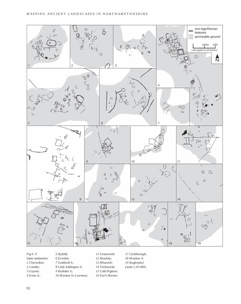
The open settlements mainly compriseloose groups of hut circles, together with smallrectilinear, polygonal or curvilinear enclosuresand clusters of pits (Fig 6.9). Small, square orrectilinear enclosures, often no larger than hutcircles, are a particularly common feature atthese sites (for example in Fig 6.9: 1, 6.9: 5,6.9: 12). Shaw and Blinkhorn have suggestedthat the examples investigated at Top Lodge,Ringstead, may have been building enclosuresor stock pens (1992, 5). Features of similarplan and scale have been excavated in theOuse Valley and found to be stone-filledgullies, which Dawson has suggested are theremains of a new type of house structure that
M A P P I N G A N C I E N T L A N D S C A P E S I N N O RT H A M P T O N S H I R E
90
appeared in the 1st century BC (2000, 115).Slightly larger enclosures, up to 0.1ha in sizewith an oval, rectangular, polygonal or eventriangular plan are present at many of the opensettlements (see Fig 6.9: 1, 6.9: 7, 6.9: 17, 6.9:
18). Two small, oval enclosures investigated at Sywell Aerodrome and Great Houghtonwere associated with nearby huts andconsidered to be related to stock management(Atkins et al 2000; Chapman 2000–1).
L AT E B R O N Z E A G E , I R O N A G E A N D R O M A N S E T T L E M E N T S A N D L A N D S C A P E S
91
Fig 6.8 Distribution of isolated hutcircles, open settlements andforts (see Fig 6.2 for key tohillforts) (scale 1:400 000).
510000,305000
450000,305000
450000,230000
510000,230000
N
2
1
3
4
5
6
8
9
7
10
11
land of high and medium cropmark amenability in Northamptonshire
larger open settlement
other open settlement
hillfort with possible LBA-EIA origins
undated or later hillfort
isolated hut circle
0 5km 10
M A P P I N G A N C I E N T L A N D S C A P E S I N N O RT H A M P T O N S H I R E
92
1 2 3
4
5 6 7
8
9 10 11
12 13 14
15 16 17 18 19
permeable ground
Iron Age/Roman features
N
100m0 200
scale applies to all extracts
Fig 6. 9 Open settlements:1 Charwelton; 2 Catesby; 3 Gayton; 4 Ecton A;
5 Byfield; 6 Everdon; 7 Scaldwell A; 8 Little Addington A; 9 Rushden A; 10 Marston St Lawrence;
11 Greatworth; 12 Brackley; 13 Blisworth; 14 Titchmarsh; 15 Cold Higham; 16 Earl’s Barton;
17 Litchborough; 18 Moulton A; 19 Bugbrooke) (scale 1:10 000).
A second, perhaps slightly earlier enclosure at Great Houghton yielded evidence fordomestic activity and iron working, but alsocontained a pit group with a crouchedinhumation (Chapman 2000–1, 31).
Similar small enclosures also occur inloosely-grouped clusters where evidence ofround houses is absent (see Fig 6.9: 14)Some of these may also be the remains ofopen settlements with dwelling structuresthat remain hidden, either because their ringgullies are too slight to produce cropmarksin the local ground conditions, or have beenploughed out, or perhaps because they weresolely post-built structures without anytrench or eaves drip.
Pits appear at many of the opensettlements, but their apparent absence atsome may be due in no small part to theunderlying soils and geology, and is notnecessarily an accurate reflection of theburied archaeology. Large pit clusters wererecorded adjacent to the open settlements atMarston St Lawrence, Brackley, Blisworthand Cold Higham (see Fig 6.9: 10, 6.9: 12,6.9: 13 and 6.9: 15). There are othersignificant clusters at Staverton (see Fig6.16: 5) and at Farthinghoe (see Fig 6.3).These groups of pits, often tightly-clustered,were long considered to be receptacles forgrain storage, and thus an indication of the relative importance of arable cultivationto the settlement’s economy (for exampleKeighley 1981, 119–20). Interestinglythough, many of the settlements with pitclusters are located on rather smallexposures of permeable geology and aresurrounded by heavier clay soils that at thetime would have been more conducive topastoral than to arable farming. Generalisedinterpretations of pits as storage or refusereceptacles have been disputed by Hill(1992), and the ritualistic elements of pit deposits in the county are beginning tobe recognised as a result of work at Great Houghton and Twywell (Chapman2000–1, 31).
At Great Doddington, the massive ditchof the D-shaped enclosure appeared to cutacross at least one hut circle in theunexcavated section, and close by, at Wilby Way, Wellingborough, opensettlement was detected during excavationsof the long-lived settlement (Windell 1981,66; Thomas and Enright 2003). At EctonA, Rushden A, and Marston St Lawrencethere is clearly some degree of overlapbetween enclosures and hut circles, but atCharwelton, Little Addington A, and Cold
Higham the arrangement of features doesnot preclude coexistence or contempor-aneous use, although it does not prove iteither (compare Fig 6.9: 4, 6.9: 9, 6.9: 10with 6.9: 1, 6.9: 8 and 6.9: 15).
There are great differences in the size ofthe cropmarked unenclosed settlements;they range from 0.5ha to almost 20ha, butcomparison based on size alone is unlikelyto have much archaeological significance.One of the larger cropmark complexes withevidence of unenclosed settlement runsalong a low spur in the parishes of Sywelland Ecton (see Fig 6.9: 4). The spur isbounded on two sides by minor streams andit gently descends south-eastward towardsthe River Nene. This was an area of denseprehistoric activity and the evidence for theopen settlement is intermingled with earliermonuments and later enclosures and fields.A small area of settlement has beenexcavated and dated to the 4th–2ndcenturies BC (Atkins et al 2000). However,even the most extensive sites may be theresult of ‘short distance settlement drift’ ofone or more foci, and may have actuallysupported a much smaller community atany one time than the total hut count wouldsuggest (Jackson 1975, 66).
The cropmark evidence is furthercomplicated by the differences in cropresponse to buried features in differentlocations. The analyses in chapter 3identified the areas where cropmarks coulddevelop most readily, but this does notmean that all cropmarks in these areas willdevelop with equal clarity and detail, letalone be photographed when showing attheir optimum. The NMP process does notrecord the quality of the cropmarks and,while this can only ever be a subjectiveappraisal, this may have been useful whencomparing the presence or absence offeatures between sites. Thus, while theappearance of the sites at Byfield andScaldwell A is very different, the rather faintand ill-defined cropmarks of the latter maybelie a site of greater complexity and size(compare Fig 6.9: 5 with 6.9: 7).
Substantial open settlements occur morefrequently in the south-east of the county onthe watersheds between the Nene, Tove(Great Ouse tributary) and Cherwell (seeFig 6.8). Other, apparently smaller sites arescattered between the Brampton Arm of theNene and the River Ise, on the slopes ofminor valleys and across the Ironstoneupper ground, as defined by PhysiographicModel of the county (Northamptonshire
L AT E B R O N Z E A G E , I R O N A G E A N D R O M A N S E T T L E M E N T S A N D L A N D S C A P E S
93
Archaeology 2003). Open settlements aremore sparsely distributed along the NeneValley floor and sides, although otherexamples may have been concealed by thesuperimposed cropmarks of unrelatedenclosures and field boundaries that are sodensely distributed across the permeablegeologies in this zone.
At Byfield and Blisworth pit alignmentsrun along the edge of the visible settlementremains but at Ecton A, Rushden A,Greatworth, and Thorpe Mandeville longlinear boundaries appear to act as the focus of the settlement (compare Fig 6.9: 5,6.9: 13 with 6.9: 4, 6.9: 9, 6.9: 11 and Fig 6.10: 7).
The same juxtaposition of pit alignmentand open settlement was found under the villa at Wootton Fields but unfortunatelythe nature of the relationship could not be tested (NA 1999b). Assuming that thesuggested chronology is correct, thesearrangements indicate that, althoughperhaps originally intended as peripheralmarkers, the pit alignments and ditches later became the focus of activity andsettlement.
Hillforts
The defences of the Crow Hill, Irthling-borough, and Castle Yard, Farthingstone,hillforts may have been constructed in theMiddle Iron Age (Knight 1986–7, 39; Kidd 1999). Both are of sub-rectangularplan and about 2.5ha in size. The recentlyrecognised hillfort at Guilsborough, whichsurvived only as a very low earthwork andwas not visible from the air, is of a similarplan and may be of this period, as may any of the undated possible hillforts atArbury Camp, Arbury Hill, and unusualEgg Rings enclosure at Salcey (Woodfield1980; Pattison and Oswald 1993–4).
The defences of the Hunsbury,Rainsborough and Guilsborough hillfortswere probably remodelled at times in theMiddle Iron Age, but only Crow Hill has produced evidence for Late Iron Agehillfort strengthening (Kidd 1999, 6 and 8).
The majority of the known and possiblehillforts were built on the higher ground in the west of the county and, although theyare clearly not all contemporary, they arerelatively evenly distributed there (see Fig6.8). The hillforts at Arbury Hill, CastleYard, Hunsbury and Crow Hill are eachsituated in elevated positions overlookingthe Nene Valley.
Land division and boundaries
The land parcels established on the valleyfloor at Wollaston in the Late Bronze Ageand Early Iron Age continued in usethrough the Middle and Late Iron Age(Meadows 1995). At Gretton, a hoard ofcurrency bars was buried near theintersection of a pit alignment and ditch,probably in the last century BC (Jackson1974). Although the pits and ditch have notbeen securely dated, the insertion of thehoard into the edge of one of the pitssuggests that these boundaries wereprobably visible in the landscape at the time of burial.
It is likely that the systems of landdivision recorded in many other parts of the county also persisted through to theRoman period, but this is not to suggestthat, once established, there was stasis in the planned landscapes. The maintenanceand development of pit and ditch-definedboundaries from the Early Iron Age and the subsequent millennium is an intriguingissue and one not yet fully resolved by excavation.
On Briar Hill an alignment of regularoblong pits had cut the line of an earlyboundary. This consisted of two, presumedcontemporary, rows of smaller, morecircular pits, some of which may have heldtimber uprights (Jackson 1974, 15). Thelater Briar Hill pit alignment and theGretton example appeared to have beendeliberately back-filled, in the case of thelatter possibly within a year of construction(Jackson 1974).
It has already been noted that the grid-like arrangement at Wollaston may havebeen preceded by an earlier system on a different alignment (see above). Minorrearrangements of the pit alignmentsobserved during excavations in theneighbouring parish of Grendon may havebeen a response to changing groundconditions and, in particular, increasingwetness from a rising water table (Jackson1997, 9–10).
At Wollaston some of the pit alignmentswere re-cut by ditches or replaced byhedges, and it was noted that the usualdetritus of occupation, including charcoaland pot sherds, was absent from the pit fills (Meadows 1995; Kidd 1999). Thesterility of fills is a frequent observation,and, while this may often reflect rapid back-filling, it does not preclude a long historythat was interspersed with events of
M A P P I N G A N C I E N T L A N D S C A P E S I N N O RT H A M P T O N S H I R E
94
scrupulous cleaning or re-cutting of the pits.Clearly the apparent transience of theexcavated pit alignments is incongruouswith both the considerable labour requiredfor their construction and the impact theyhad on the pattern of subsequent settlement(see below).
At Harlestone, Pitsford, and Kettonelements of these rectilinear frameworkswere further formalised with thedevelopment of well-established trackwaysand, later, perhaps roads, which bearevidence of considerable compaction oreven hard surfacing, although these eventsare untested and undated (see Figs 6.4, 6.5and 6.7).
However, there are, in certain parts ofthe county, boundaries or trackways that donot conform to the regular rectilinearcharacteristics of the apparently plannedlandscapes. These display a degree ofsinuosity that sets them apart from thetrackways seen at Harlestone, Pitsford andfar exceeds any influence the often rathergentle local topography may have had. The most extensive example is a double-ditched feature that meandered for nearlythree kilometres across boulder clay andOxford Clay through the parish ofTitchmarsh. Another is the broad-ditchedlinear feature that descended from theboulder-clay-capped plateau down toHarper’s Brook through Brigstock (see Fig6.13: 1). Inevitably, dating of these longlinear features is lacking, and in many casesit is not clear if the features are boundariesor ditched trackways. Recent photographyof a sinuous double-ditched trackway atStrixton shows it was defined in parts by pits, which may indicate an Early IronAge date (see Fig 6.13: 2).
Enclosed settlement
A record of nearly 5,000 possible Iron Ageand Roman period enclosures demonstratesthe expansion in enclosure building duringthe Middle and Late Iron Age. However, thepersistence of open occupation at leastthrough the Middle Iron Age, as atGeddington and Twywell, and probably upto the last century BC, as at GreatHoughton, Sywell, Ecton and Wakerley,suggests that there was not a complete shiftto enclosed settlement (Jackson 1975,1979a; Jackson and Ambrose 1978; Atkinset al 2000; Chapman 2000–1).
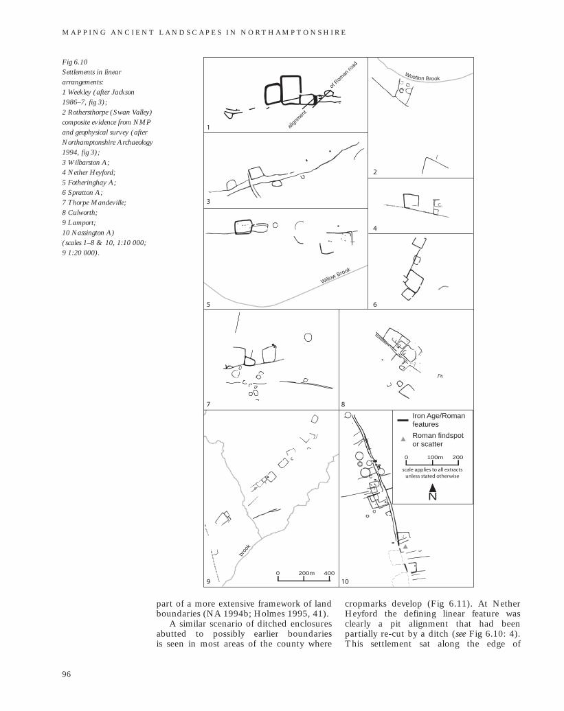
The rural landscape of Iron Age andRoman Northamptonshire was apparently
characterised by both single enclosures andgroups of varying complexity and longevity,although not all would have containedsettlement. Enclosure B at Wakerley wascontemporary with the open settlement, butapparently never occupied, and when it wasreinstated during the Roman period it wasthe focus of agricultural and industrialactivity (Jackson and Ambrose 1978).Enclosures probably served a range offunctions, including stock management,agricultural processing, industrial and craftactivities; doubtless their function changedand developed over time, but in most casesthey do indicate nearby occupation.
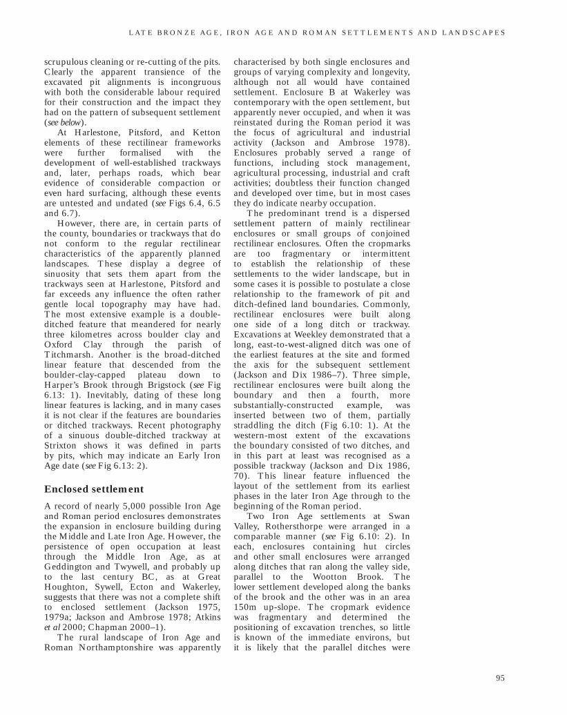
The predominant trend is a dispersedsettlement pattern of mainly rectilinearenclosures or small groups of conjoinedrectilinear enclosures. Often the cropmarksare too fragmentary or intermittent to establish the relationship of thesesettlements to the wider landscape, but insome cases it is possible to postulate a closerelationship to the framework of pit andditch-defined land boundaries. Commonly,rectilinear enclosures were built along one side of a long ditch or trackway.Excavations at Weekley demonstrated that along, east-to-west-aligned ditch was one ofthe earliest features at the site and formedthe axis for the subsequent settlement(Jackson and Dix 1986–7). Three simple,rectilinear enclosures were built along theboundary and then a fourth, moresubstantially-constructed example, wasinserted between two of them, partiallystraddling the ditch (Fig 6.10: 1). At thewestern-most extent of the excavations the boundary consisted of two ditches, andin this part at least was recognised as apossible trackway (Jackson and Dix 1986,70). This linear feature influenced thelayout of the settlement from its earliestphases in the later Iron Age through to thebeginning of the Roman period.
Two Iron Age settlements at SwanValley, Rothersthorpe were arranged in acomparable manner (see Fig 6.10: 2). Ineach, enclosures containing hut circles and other small enclosures were arrangedalong ditches that ran along the valley side,parallel to the Wootton Brook. The lower settlement developed along the banksof the brook and the other was in an area150m up-slope. The cropmark evidence was fragmentary and determined thepositioning of excavation trenches, so littleis known of the immediate environs, but it is likely that the parallel ditches were
L AT E B R O N Z E A G E , I R O N A G E A N D R O M A N S E T T L E M E N T S A N D L A N D S C A P E S
95
part of a more extensive framework of landboundaries (NA 1994b; Holmes 1995, 41).
A similar scenario of ditched enclosuresabutted to possibly earlier boundaries is seen in most areas of the county where
cropmarks develop (Fig 6.11). At NetherHeyford the defining linear feature wasclearly a pit alignment that had beenpartially re-cut by a ditch (see Fig 6.10: 4).This settlement sat along the edge of
M A P P I N G A N C I E N T L A N D S C A P E S I N N O RT H A M P T O N S H I R E
96
Fig 6.10 Settlements in lineararrangements: 1 Weekley (after Jackson1986–7, fig 3); 2 Rothersthorpe (Swan Valley)composite evidence from NMPand geophysical survey (afterNorthamptonshire Archaeology1994, fig 3); 3 Wilbarston A; 4 Nether Heyford; 5 Fotheringhay A; 6 Spratton A; 7 Thorpe Mandeville; 8 Culworth; 9 Lamport; 10 Nassington A) (scales 1–8 & 10, 1:10 000; 9 1:20 000).
Wootton Brook
Willow Brook
broo
k
1
2
3
4
5 6
9 10
7 8
align
men
t
of R
oman
road
200m0 400
N
100m0 200
scale applies to all extracts unless stated otherwise
Roman findspot or scatter
Iron Age/Roman features
the valley floor with the river to the north. A similar arrangement of small,rectilinear enclosures developed on the same orientation 1km to the south-west,and on the north side of the river the
same trend was observed in a second pitalignment and the positioning of otherditches and enclosures.
The string of enclosures at Lamportmaintained a common orientation over a
L AT E B R O N Z E A G E , I R O N A G E A N D R O M A N S E T T L E M E N T S A N D L A N D S C A P E S
97
510000,305000
450000,305000
450000,230000
510000,230000
N
2
1
3
4
5
6
8
9
7
10
11
land of high and medium cropmark amenability in Northamptonshire
settlement in grid-like arrangement
settlement in sinuous linear arrangement
hillfort with possible LBA-LIA origins
other settlements (including those too incomplete to classify)
settlement in straight linear arrangement
0 5km 10Fig 6.11 Distribution of settlementsarranged in a regular linear orgrid-like pattern and thoseassociated with more sinuousand irregular boundaries ortrackways(scale 1:400 000)(see Fig 6.2 for key to hillforts).
M A P P I N G A N C I E N T L A N D S C A P E S I N N O RT H A M P T O N S H I R E
98
land 21-30m above OD
land 31-40m
land 41-50m
land 51-60m
land 61-70m
land 71-80m
land 81-90m
land 91-100m
land 101-110m
land 111-120m
land 121-130m
N200m0 400
scale applies to all extracts
Roman findspot or scatter
Iron Age findspot or scatter
Iron Age/Roman features
pit alignment
1 2
7
5 4 3
12
8
6
9
10 11
distance of more than 1km, and perhapsover a long period of development, althoughno axial boundary was visible (see Fig 6.10:9). These remains lie on Upper Lias Clay,and the enclosure ditches produced ratherfaint cropmarks. The alignment of thesettlement continued northwards in a longtrackway that climbed up onto theNorthamptonshire Sand and Ironstone.
A possible settlement at Wilbarston Adeveloped in small rectilinear enclosureseither side of a broad track or droveway (seeFig 6.10: 3). The trackway ran along theedge of the boulder-clay-capped plateau andoverlooked a tributary of the River Welland.On the valley side below and parallel to this,the fragmentary remains of a pit and ditch-defined series of land units were visible.
On Thenford Hill, Thorpe Mandeville,three rectilinear enclosures abut the northside of an east-to-west-aligned ditch (see Fig6.10: 7). A second ditch or trackway, of nearparallel orientation defined the southernlimit of a narrow strip of land and wasperhaps the focus for the unenclosedsettlement. The hillfort was constructed onthe southern edge of the same hilltop.
At Wollaston it was the intersectionsbetween the boundaries that appear to havebeen the focus of settlement (see Fig 6.1).Farmsteads were built into the corners ofthe land parcels laid out some centuriesbefore. The result was a community of small settlements dispersed across a grid ofland boundaries on the valley floor. AtHardwick Park, Wellingborough, in an areanow covered by housing, excavatorsrevealed an orderly series of enclosuresoverlooking a stream (Foster et al 1977).The enclosures are thought to have beenstockyards, and occupation evidence wasidentified in small enclosures built into thecorners of one such yard.
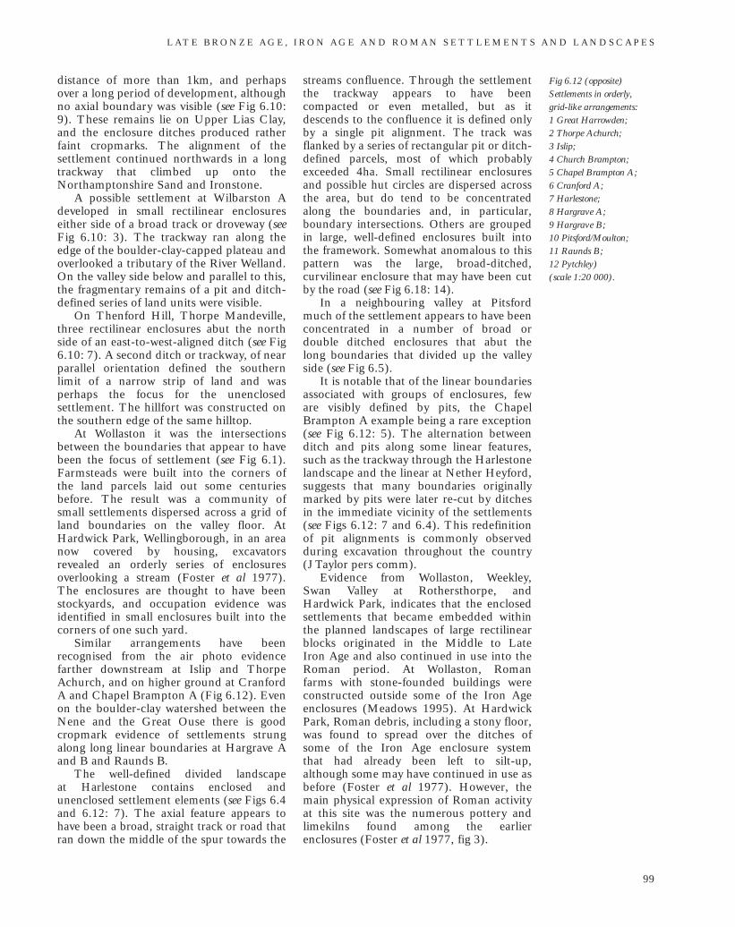
Similar arrangements have beenrecognised from the air photo evidencefarther downstream at Islip and ThorpeAchurch, and on higher ground at CranfordA and Chapel Brampton A (Fig 6.12). Evenon the boulder-clay watershed between theNene and the Great Ouse there is good cropmark evidence of settlements strungalong long linear boundaries at Hargrave Aand B and Raunds B.
The well-defined divided landscape at Harlestone contains enclosed andunenclosed settlement elements (see Figs 6.4and 6.12: 7). The axial feature appears tohave been a broad, straight track or road thatran down the middle of the spur towards the
streams confluence. Through the settlementthe trackway appears to have beencompacted or even metalled, but as itdescends to the confluence it is defined onlyby a single pit alignment. The track wasflanked by a series of rectangular pit or ditch-defined parcels, most of which probablyexceeded 4ha. Small rectilinear enclosuresand possible hut circles are dispersed acrossthe area, but do tend to be concentratedalong the boundaries and, in particular,boundary intersections. Others are groupedin large, well-defined enclosures built intothe framework. Somewhat anomalous to thispattern was the large, broad-ditched,curvilinear enclosure that may have been cutby the road (see Fig 6.18: 14).
In a neighbouring valley at Pitsfordmuch of the settlement appears to have beenconcentrated in a number of broad ordouble ditched enclosures that abut the long boundaries that divided up the valleyside (see Fig 6.5).
It is notable that of the linear boundariesassociated with groups of enclosures, feware visibly defined by pits, the ChapelBrampton A example being a rare exception(see Fig 6.12: 5). The alternation betweenditch and pits along some linear features,such as the trackway through the Harlestonelandscape and the linear at Nether Heyford,suggests that many boundaries originallymarked by pits were later re-cut by ditchesin the immediate vicinity of the settlements(see Figs 6.12: 7 and 6.4). This redefinitionof pit alignments is commonly observedduring excavation throughout the country (J Taylor pers comm).
Evidence from Wollaston, Weekley,Swan Valley at Rothersthorpe, andHardwick Park, indicates that the enclosedsettlements that became embedded withinthe planned landscapes of large rectilinearblocks originated in the Middle to Late Iron Age and also continued in use into theRoman period. At Wollaston, Roman farms with stone-founded buildings wereconstructed outside some of the Iron Ageenclosures (Meadows 1995). At HardwickPark, Roman debris, including a stony floor,was found to spread over the ditches ofsome of the Iron Age enclosure system that had already been left to silt-up,although some may have continued in use asbefore (Foster et al 1977). However, themain physical expression of Roman activityat this site was the numerous pottery andlimekilns found among the earlierenclosures (Foster et al 1977, fig 3).
L AT E B R O N Z E A G E , I R O N A G E A N D R O M A N S E T T L E M E N T S A N D L A N D S C A P E S
99
Fig 6.12 (opposite)Settlements in orderly, grid-like arrangements: 1 Great Harrowden; 2 Thorpe Achurch; 3 Islip; 4 Church Brampton; 5 Chapel Brampton A; 6 Cranford A; 7 Harlestone; 8 Hargrave A; 9 Hargrave B; 10 Pitsford/Moulton; 11 Raunds B; 12 Pytchley) (scale 1:20 000).
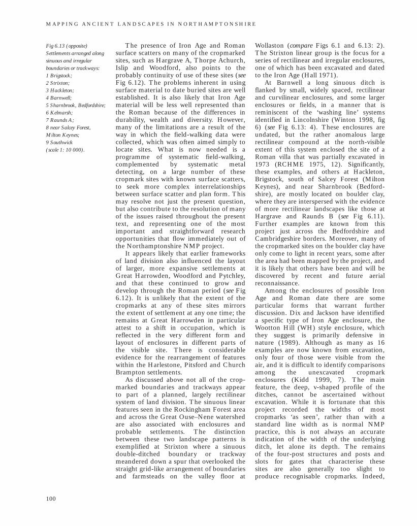
The presence of Iron Age and Romansurface scatters on many of the cropmarkedsites, such as Hargrave A, Thorpe Achurch,Islip and Woodford, also points to theprobably continuity of use of these sites (seeFig 6.12). The problems inherent in usingsurface material to date buried sites are wellestablished. It is also likely that Iron Agematerial will be less well represented thanthe Roman because of the differences indurability, wealth and diversity. However,many of the limitations are a result of theway in which the field-walking data werecollected, which was often aimed simply tolocate sites. What is now needed is aprogramme of systematic field-walking,complemented by systematic metaldetecting, on a large number of thesecropmark sites with known surface scatters,to seek more complex interrelationshipsbetween surface scatter and plan form. Thismay resolve not just the present question,but also contribute to the resolution of manyof the issues raised throughout the presenttext, and representing one of the mostimportant and straightforward researchopportunities that flow immediately out ofthe Northamptonshire NMP project.
It appears likely that earlier frameworksof land division also influenced the layout of larger, more expansive settlements atGreat Harrowden, Woodford and Pytchley,and that these continued to grow anddevelop through the Roman period (see Fig6.12). It is unlikely that the extent of thecropmarks at any of these sites mirrors the extent of settlement at any one time; theremains at Great Harrowden in particularattest to a shift in occupation, which isreflected in the very different form andlayout of enclosures in different parts of the visible site. There is considerableevidence for the rearrangement of featureswithin the Harlestone, Pitsford and ChurchBrampton settlements.
As discussed above not all of the crop-marked boundaries and trackways appear to part of a planned, largely rectilinearsystem of land division. The sinuous linearfeatures seen in the Rockingham Forest areaand across the Great Ouse–Nene watershedare also associated with enclosures andprobable settlements. The distinctionbetween these two landscape patterns isexemplified at Strixton where a sinuousdouble-ditched boundary or trackwaymeandered down a spur that overlooked thestraight grid-like arrangement of boundariesand farmsteads on the valley floor at
Wollaston (compare Figs 6.1 and 6.13: 2).The Strixton linear group is the focus for aseries of rectilinear and irregular enclosures,one of which has been excavated and datedto the Iron Age (Hall 1971).
At Barnwell a long sinuous ditch isflanked by small, widely spaced, rectilinearand curvilinear enclosures, and some largerenclosures or fields, in a manner that isreminiscent of the ‘washing line’ systemsidentified in Lincolnshire (Winton 1998, fig6) (see Fig 6.13: 4). These enclosures areundated, but the rather anomalous largerectilinear compound at the north-visibleextent of this system enclosed the site of aRoman villa that was partially excavated in1973 (RCHME 1975, 12). Significantly,these examples, and others at Hackleton,Brigstock, south of Salcey Forest (MiltonKeynes), and near Sharnbrook (Bedford-shire), are mostly located on boulder clay,where they are interspersed with the evidenceof more rectilinear landscapes like those atHargrave and Raunds B (see Fig 6.11).Further examples are known from this project just across the Bedfordshire andCambridgeshire borders. Moreover, many ofthe cropmarked sites on the boulder clay haveonly come to light in recent years, some afterthe area had been mapped by the project, andit is likely that others have been and will bediscovered by recent and future aerialreconnaissance.
Among the enclosures of possible IronAge and Roman date there are someparticular forms that warrant furtherdiscussion. Dix and Jackson have identifieda specific type of Iron Age enclosure, theWootton Hill (WH) style enclosure, whichthey suggest is primarily defensive in nature (1989). Although as many as 16examples are now known from excavation,only four of those were visible from the air, and it is difficult to identify comparisonsamong the unexcavated cropmarkenclosures (Kidd 1999, 7). The mainfeature, the deep, v-shaped profile of theditches, cannot be ascertained withoutexcavation. While it is fortunate that thisproject recorded the widths of mostcropmarks ‘as seen’, rather than with astandard line width as is normal NMPpractice, this is not always an accurateindication of the width of the underlyingditch, let alone its depth. The remains of the four-post structures and posts andslots for gates that characterise these sites are also generally too slight to produce recognisable cropmarks. Indeed,
M A P P I N G A N C I E N T L A N D S C A P E S I N N O RT H A M P T O N S H I R E
100
Fig 6.13 (opposite)Settlements arranged alongsinuous and irregularboundaries or trackways: 1 Brigstock; 2 Strixton; 3 Hackleton; 4 Barnwell; 5 Sharnbrook, Bedfordshire; 6 Kelmarsh; 7 Raunds A; 8 near Salcey Forest,Milton Keynes; 9 Southwick (scale 1: 10 000).
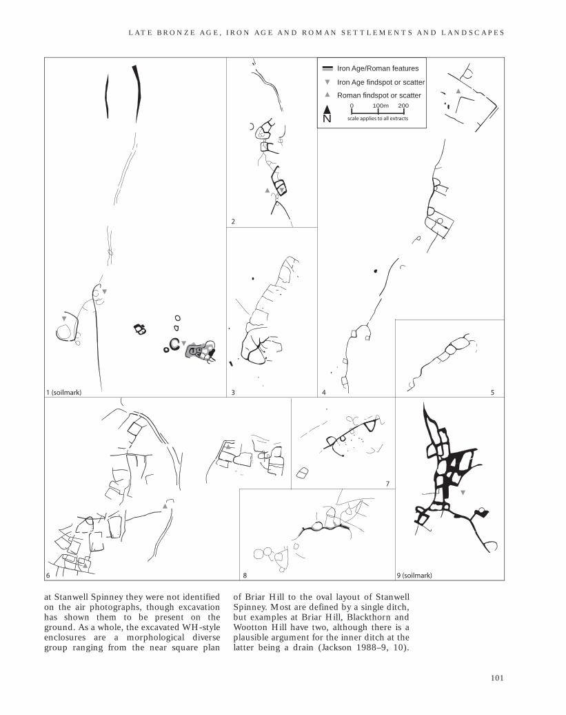
at Stanwell Spinney they were not identifiedon the air photographs, though excavationhas shown them to be present on theground. As a whole, the excavated WH-styleenclosures are a morphological diversegroup ranging from the near square plan
of Briar Hill to the oval layout of StanwellSpinney. Most are defined by a single ditch,but examples at Briar Hill, Blackthorn andWootton Hill have two, although there is aplausible argument for the inner ditch at thelatter being a drain (Jackson 1988–9, 10).
L AT E B R O N Z E A G E , I R O N A G E A N D R O M A N S E T T L E M E N T S A N D L A N D S C A P E S
101
1 (soilmark)
2
3 5
6
7
4
8 9 (soilmark)
N100m0 200
scale applies to all extracts
Iron Age findspot or scatter
Roman findspot or scatter
Iron Age/Roman features
Moreover if, as is suggested by Dix andJackson (1989, 166), the WH-styleenclosures were specifically a defensiveresponse to the situation in the area between100 BC to 100 AD, then any furthercandidates for this type must of be of thisdate and un-excavated enclosures simplycannot be dated with such accuracy, if at all.
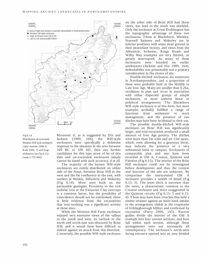
The majority of the known WH-styleenclosures are evenly distributed on eitherside of the Nene, between Briar Hill in thewest and the Ise confluence in the east, withoutliers at Weekly, Aldwincle and Wakerley(Fig 6.14). Most were built on thepermeable geologies. Proximity to the richnodular iron at the Estuarine Clay outcropsis a common factor, but the possibility ofcoincidence should not be overlooked; thereis little evidence from the excavations that iron-working was a significant activityat these sites.
While the Wootton Hill Farm enclosureenjoyed very extensive views of the valleys to the south and west, its outlook to thenorth and north-east was obscured by BriarHill, and it would have been difficult todefend against an attack from this direction.Conversely, the possible WH-style enclosure
on the other side of Briar Hill had thoseviews, but land to the south was shielded.Only the enclosure at Great Doddington hasthe topographic advantage of these twoenclosures. Those at Blackthorn, Weekley,Stanwell Spinney and Wakerley are ininferior positions with some dead ground intheir immediate vicinity, and views from theAldwincle, Irchester, Kings Heath andWilby Way examples are very limited, orgreatly interrupted. As many of theseenclosures were founded on earliersettlements (Jackson and Dix 1989, 164),defendability was presumably not a primaryconsideration in the choice of site.
Double-ditched enclosures are numerousin Northamptonshire, and a proportion ofthese were probably built in the Middle toLate Iron Age. Many are smaller than 0.2ha,rectilinear in plan and occur in associationwith either dispersed groups of simpleenclosures, or more ordered linear orpolyfocal arrangements. The BlackthornWH-style enclosure is of this form, but mostexamples probably fulfilled a range offunctions from settlement to stockmanagement, and the presence of twoditches may have been incidental to their use.
The possible double-ditched WH-styleenclosure on Briar Hill was significantlylarger, and trial excavation produced a smallamount of Iron Age pottery. The ditcheswere more than 2m wide and set 13m apart,which, even allowing for a generous berm,may indicate the presence of a verysubstantial bank or rampart. Enclosures ofcomparable plan and size have beenrecorded at Old A, Creaton, Quinton andFinedon (Fig 6.15). The interior of the BriarHill enclosure could not be investigatedbefore development and thus the contextand function of the site are unknown. Bycomparison the unexcavated Old Aenclosure provides a wealth of detail (Fig6.15: 3). The inner ditch is narrower thanthe outer, a characteristic common to theCreaton enclosure and more exaggerated inthe Quinton circuits (Fig 6.15: 5 and 6.15:4). These may have been trenches that held atimber retainer against an inner bank similarto the arrangement visible in the cropmarksof Irthlingborough hillfort and confirmed byexcavation (Parry 2006, 145). Narrowgullies divide the interior of the Old Aexample into four uneven sections, and hutsfall within each section, although thesearrangements were not necessarily allcontemporary. The enclosure’s north-westfacing entrance opened into an area divided
M A P P I N G A N C I E N T L A N D S C A P E S I N N O RT H A M P T O N S H I R E
102
Fig 6.14 Distribution of excavatedWootton Hill style enclosures(after Jackson 1998–9, Kidd 1999, 7) and largeenclosures (see Fig 6.15)(scale 1:725 000).
510000,305000
450000,305000
450000,230000
510000,230000
N
0 5km 10
large enclosure (see Fig 6.15)
land of high and medium cropmark amenability in NorthamptonshireWootton Hill style enclosure
LBA to LIA and possible hillfort
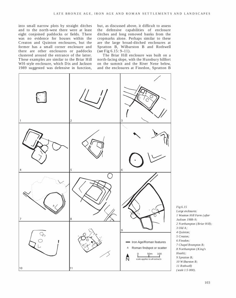
into small narrow plots by straight ditchesand to the north-west there were at leasteight conjoined paddocks or fields. Therewas no evidence for houses within theCreaton and Quinton enclosures, but theformer has a small corner enclosure andthere are other enclosures or paddocksclustered around the entrance of the latter.These examples are similar to the Briar HillWH-style enclosure, which Dix and Jackson1989 suggested was defensive in function,
but, as discussed above, it difficult to assessthe defensive capabilities of enclosureditches and long removed banks from thecropmarks alone. Perhaps similar to theseare the large broad-ditched enclosures atSpratton B, Wilbarston B and Rothwell (see Fig 6.15: 9–11).
The Briar Hill enclosure was built on anorth-facing slope, with the Hunsbury hillforton the summit and the River Nene below,and the enclosures at Finedon, Spratton B
L AT E B R O N Z E A G E , I R O N A G E A N D R O M A N S E T T L E M E N T S A N D L A N D S C A P E S
103
Fig 6.15 Large enclosures: 1 Wootton Hill Farm (afterJackson 1988–9; 2 Northampton (Briar Hill); 3 Old A; 4 Quinton; 5 Creaton; 6 Finedon; 7 Chapel Brampton B; 8 Northampton (King’sHeath); 9 Spratton B; 10 Wilbarston B; 11 Rothwell) (scale 1:5 000).
1 2 3
4 5 6
9
10
7 8
11
N50m0 100
scale applies to all extracts
Roman findspot or scatter
Iron Age/Roman features
and Rothwell likewise occupy mid-to-top-of-slope positions. Each of the examplesat Old A, Quinton and Creaton wereconstructed in low-lying positions, butwithin 500m of a major stream and
with water courses on three sides.Only the Chapel Brampton B enclosure
has produced surface finds, but this may be due simply to a lack of field-walking atthe other sites.
M A P P I N G A N C I E N T L A N D S C A P E S I N N O RT H A M P T O N S H I R E
104
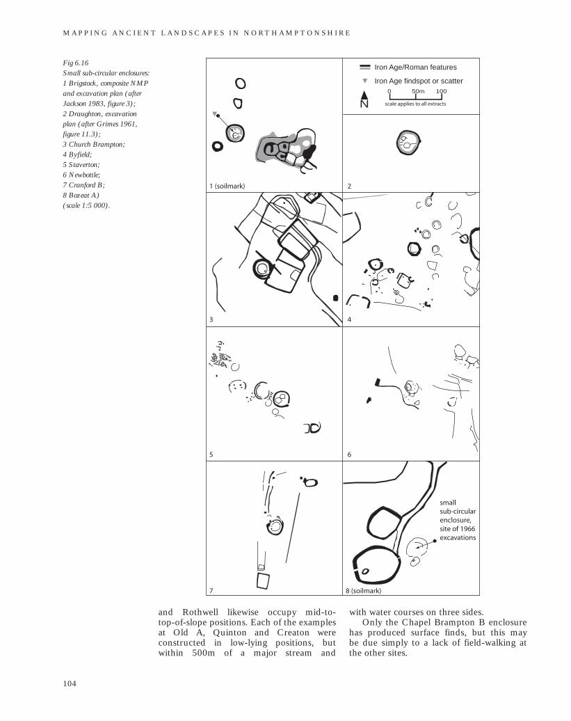
Fig 6.16 Small sub-circular enclosures: 1 Brigstock, composite NMPand excavation plan (afterJackson 1983, figure 3); 2 Draughton, excavation plan (after Grimes 1961, figure 11.3); 3 Church Brampton; 4 Byfield; 5 Staverton; 6 Newbottle; 7 Cranford B; 8 Bozeat A) (scale 1:5 000).
1 (soilmark) 2
3 4
5 6
7 8 (soilmark)
N50m0 100
scale applies to all extracts
Iron Age findspot or scatter
Iron Age/Roman features
small sub-circular enclosure, site of 1966 excavations
In their discussion of the Wootton HillFarm and other defended enclosures, Dixand Jackson also alluded to the possibledefensive nature of two small, sub-circularenclosures at Draughton and Brigstock(1989, fig 10.3). The MonumentsProtection Programme description for theWH-style enclosure specifically excludesthese two sites, and the excavator of theDraughton enclosure conceded that it didnot hold a strong defensive position (Grimes1961, 21; MPP 1989a). Both enclosureshave been dated to the Iron Age and werecharacterised by broad ditches andsubstantial internal banks (Grimes 1961;Jackson 1983) (Fig 6.16). Space within theenclosures was limited; at Draughton,0.07ha and Brigstock just 0.04ha. Bothenclosures contained one substantial hutand possibly other smaller huts or shelters,some of which may have preceded theenclosures. Both were built on boulder clay,and survived as earthworks into the 20thcentury. The Draughton enclosure wasdestroyed during the construction of awartime airfield and the Brigstock examplewas visible as the soilmark of a recentlydenuded earthwork. The Brigstock examplelay within 30m of a tight clusteredarrangement of curvilinear enclosures, butalthough these are probably of Iron Age datethey have not been fully investigated and therelative chronology of the two sites isunknown (Jackson 1983, 18–19).
Similar to the Draughton example arethe sub-circular enclosure and its internalhut circle that were excavated at Bozeat A(see Fig 6.16: 8). The enclosure ditch was2.4m wide but only 0.9m deep, althoughsoilmarks at this site suggested that it tooonce had an internal bank (Hall 1971,SP8656/005). The internal area was againvery small. The settlement was part of agroup of recently-levelled enclosures, tracksand boundaries on the boundaries of EastonMaudit and Bozeat parishes, and amongwhich there may be other comparable sites(see Fig 6.16).
Beyond this area there were few directcomparisons, and evidence for the presenceof banks is generally unforthcoming fromlong-levelled, cropmarked sites. At ChurchBrampton, Byfield, Staverton and CranfordB there are enclosures of similar size andplan with broad ditches, each with one or more internal hut (see Fig 6.16: 3–7).The Cranford B example had a small,rectangular annex outside the broad ditch,an arrangement that is mirrored at
Newbottle (Fig 6.16: 6). The narrow circuitof the Newbottle example suggests that itwas enclosed by a palisade trench ratherthan by a ditch and bank.
Although these small sub-circularenclosures are characterised by defensive-scale boundaries it is far from clear thatdefence was their primary function. None isin a particularly strong position and theirsmall size would have left them easilysurrounded by attackers. The economy atBrigstock is thought to have centred onsheep farming and associated crafts (Jackson1983), but there would have been littlespace to harbour livestock within theseenclosures in the face of an external threat.Grimes has suggested that the Draughtonenclosure was the dwelling of iron workerswho kept their raw materials close at hand(1961). Although there was little to indicateit in the material retrieved from theexcavated examples, these sites may havebeen the expression of the different, perhapselevated status and standing of a smallfamily group. It may be of furthersignificance that several of the exampleswhere located close by other, largersettlements.
Thirty metres east of the small sub-circular enclosure at Brigstock lie the remainsof a tight cluster of small sub-circular andcurvilinear enclosures of possible Iron Agedate (Brigstock B) (Jackson 1983, 19). A recently-denuded earthwork, the well-defined soilmarks suggest the presence ofinternal banks and small internal areas (Fig 6.17: 1). Similar clusters have beenrecorded 8km to the north-east at Benefieldand in the south of the county at EastonMaudit (see Fig 6.17: 5 and 6.17: 3).Unfortunately, bank material rarely survivesin areas with a long ploughing history, so other direct comparisons are difficult tomake. However, the accreted arrangement ofsmall curvilinear enclosures is reflected insettlements at Great Houghton, Loddington,Finedon and Old B (see Fig 6.17: 2, 6.17: 4,6.17: 6 and 6.17: 9.). Trial excavations of thecluster of curvilinear enclosures at Bozeat Bhave confirmed the presence of Late Iron Age to Roman period activity in the area, but interestingly also Early to Middle Saxonremains (see Fig 6.17: 7). The nature of theelements that were visible from the air has yet to be fully revealed, but geophysicalsurvey has confirmed their presence, as well as an unseen extensive system of smallfields and paddocks and enclosures in thearea to the south.
L AT E B R O N Z E A G E , I R O N A G E A N D R O M A N S E T T L E M E N T S A N D L A N D S C A P E S
105
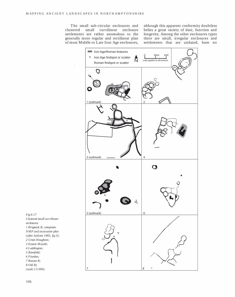
The small sub-circular enclosures andclustered small curvilinear enclosuresettlements are rather anomalous to thegenerally more regular and rectilinear planof most Middle to Late Iron Age enclosures,
although this apparent conformity doubtlessbelies a great variety of date, function andlongevity. Among the other enclosures typesthere are small, irregular enclosures andsettlements that are undated, have no
M A P P I N G A N C I E N T L A N D S C A P E S I N N O RT H A M P T O N S H I R E
106
Fig 6.17 Clustered small curvilinearenclosures: 1 Brigstock B, compositeNMP and excavation plan(after Jackson 1983, fig 3); 2 Great Houghton; 3 Easton Maudit; 4 Loddington; 5 Benefield; 6 Finedon; 7 Bozeat B; 8 Old B) (scale 1:5 000).
1 (soilmark) 2
3 (soilmark) 4
5 (soilmark) 6
7 8
N50m0 100
scale applies to all extracts Iron Age findspot or scatter
Roman findspot or scatter
Iron Age/Roman features
1
2 3 4
5 6 7 8
9 10 11 12
13 14
16
15
N50m0 100
scale applies to all extracts
Iron Age findspot or scatter
Roman findspot or scatter
Iron Age/Roman features
L AT E B R O N Z E A G E , I R O N A G E A N D R O M A N S E T T L E M E N T S A N D L A N D S C A P E S
107
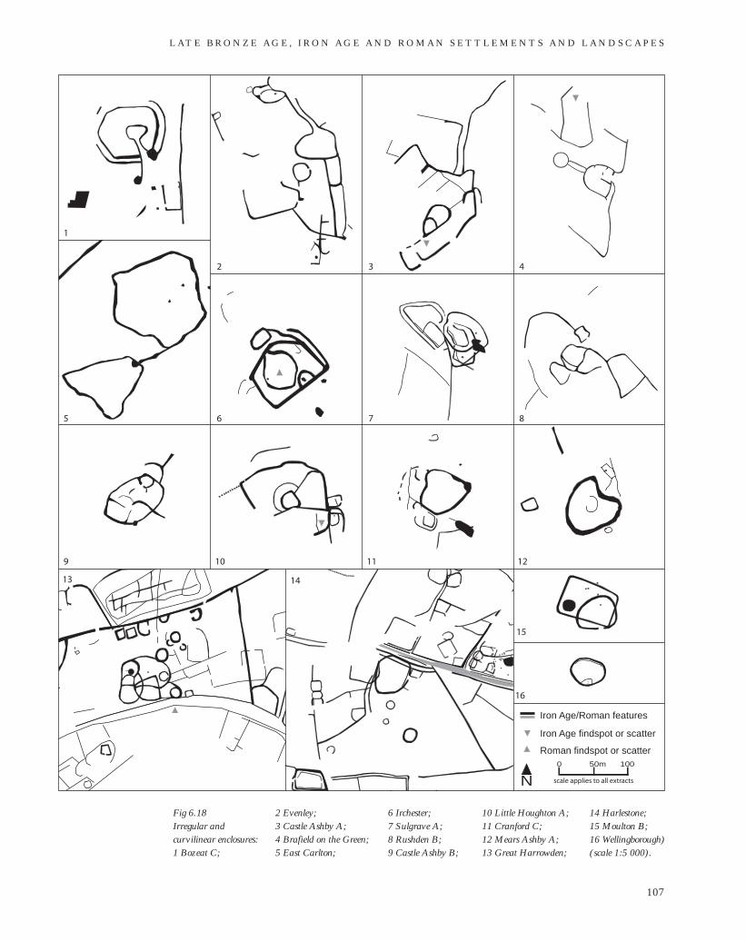
Fig 6.18 Irregular andcurvilinear enclosures: 1 Bozeat C;
2 Evenley; 3 Castle Ashby A; 4 Brafield on the Green; 5 East Carlton;
10 Little Houghton A; 11 Cranford C; 12 Mears Ashby A; 13 Great Harrowden;
6 Irchester; 7 Sulgrave A; 8 Rushden B; 9 Castle Ashby B;
14 Harlestone; 15 Moulton B; 16 Wellingborough) (scale 1:5 000).
excavated parallels and generally resistclassification. Settlements at Bozeat C,Evenly, Castle Ashby A, Brafield, Irchesterand Sulgrave A each contain a diverse rangeof enclosures and other elements, but thecommon presence of a funnel-like entranceor track invites their comparison withMiddle to Late Iron Age banjo enclosures(Fig 6.18: 1–4 and 6.18: 7).
Groups at Great Harrowden, Harlestoneand Moulton B are united by the commonjuxtaposition of the curvilinear enclosureagainst a landscape of otherwise rectilineararrangements (see Fig 6.18: 13–15). It isinteresting to note that each appears to bean early development of each site. TheWellingborough curvilinear enclosure isdistinguished by the presence of a possibleinternal palisade trench (see Fig 6.18: 16).The distinctive lobed plan of the CranfordC and Mears Ashby A enclosures is alsoseen in an element of the linear settlement atStrixton (see Figs 6.18: 11–12 and 6.13: 2).Such irregularity may arise from thepresence of unseen constraints rather than achoice of style, and so any coincidence ofplan form may be meaningless.
Farming and industry
Understanding of the nature and characterof later prehistoric farming in North-amptonshire is not particularly well-developed, and is limited to the evidence ofa few key sites (see Kidd 1999, 9).
The evidence from sites along the NeneValley floor and sides – Wollaston, Raunds,Blackthorn and Wilby Way – is consistentwith a landscape that was cleared ofwoodland by the Bronze Age and remainedopen through the Iron Age. (Williams andMcCarthy 1974; Meadows 1995; Thomasand Enright 2003; Campbell and Robinson2007). Environmental evidence of theconditions on the higher ground, theboulder clay-capped plateaux and Liasupper ground, is sparse.
Farmers in the Iron Age settlements atWollaston and Stanwick are thought to haveengaged in a mix of pastoral and arablecultivation (Robinson 1992, 205; Meadows1995, 44). The valley-side settlement atTwywell may have cultivated some crops,but the predominant activity was probablypastoralism complemented by associatedcrafts, such as weaving and possibly dyeing(Jackson 1975, 66). Beyond the valley andup onto the boulder clay, Jackson observedthat the soil was fertile but thin and, with
underlying clay, would have been difficult toplough; and that, again, the economy of thesettlement was focussed on sheep rearingand the processing of wool (1983, 21).
The small rectilinear and curvilinearenclosures, interpreted by some as animalpens, are ubiquitous at the known opensettlements and common at most other IronAge settlements, and may attest to thesignificance of pastoralism at this time.
The management of the livestock in thewider landscape is more difficult toreconcile with landscapes revealed by theproject. The pit-defined and ordered landparcels laid down in the Late Bronze Ageand Early Iron Age are unlikely to have beenthe sole agent in the containment of stock,not least because the pit alignments wouldhave been a permeable and thus ineffectivebarrier. It has been suggested that the large,sub-oval area at Newbottle, with itsfunnelled uphill exit, may have been a largecattle corral, and it is interesting that thisfeature appears to be embedded within themore regular rectilinear landscape (see Fig6.3). The funnel-like entrances of theenclosures at Bozeat C, Evenley, CastleAshby A, Brafield, Irchester and Sulgrave Amay also point to the importance ofcontrolling stock movement at these sites.
On the valley floor at Grendon a systemof undated spade-dug trenches, possibly forgrowing grape-vines, appears to be havebeen contained by the arrangement of pitalignments (Jackson 1997). In generalthough, it is perhaps unlikely that landparcels thus defined were conceived asindividual fields. It is possible that they weresubdivided by more ephemeral features,such as hedgerows or fences, marking thedivisions of ownership and to protect cropsfrom animals, both wild and domesticated.
It has been argued that the density ofIron Age settlement, the predominance ofsheep over pigs and deer, and the presenceof quernstones in the claylands aroundBrigstock indicate an open landscape withthe possibility of cereal production (Jackson1983, 22). However, there is insufficientevidence to support or refute this inference.Robinson has noted that although theboulder clay areas of both the RockinghamForest area and the Nene-Ouse watershedwere occupied at this time, this affected nomajor changes on the Nene floodplain in themanner that extensive ploughing was to doin the Late Saxon and medieval periods,when arable expansion over most of theboulder clay plateaux is well documented
M A P P I N G A N C I E N T L A N D S C A P E S I N N O RT H A M P T O N S H I R E
108
(1992, 206). The absence of any indicationof a major alluviation event on the valleyfloor at this time suggests that ploughingand cultivation on the boulder-clay-capped watersheds were minimal, and that astable ground surface was maintained bypermanent grassland and, in some areas,woodland as the following industrialevidence implies.
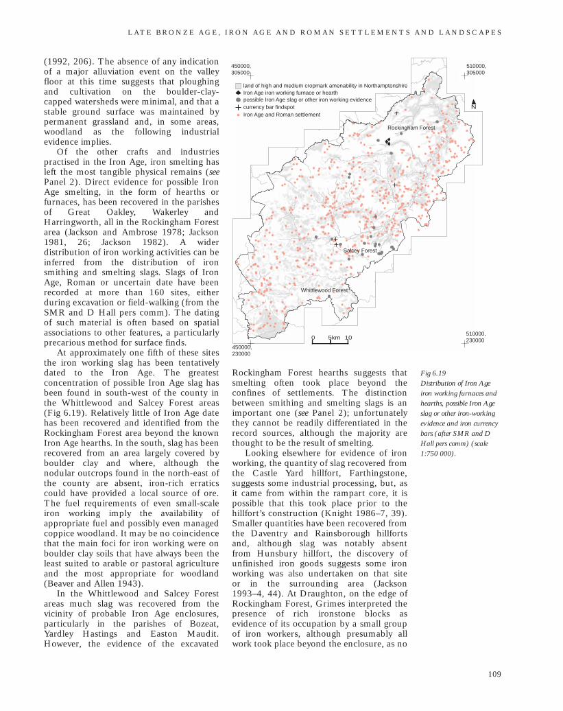
Of the other crafts and industriespractised in the Iron Age, iron smelting hasleft the most tangible physical remains (seePanel 2). Direct evidence for possible IronAge smelting, in the form of hearths orfurnaces, has been recovered in the parishesof Great Oakley, Wakerley andHarringworth, all in the Rockingham Forestarea (Jackson and Ambrose 1978; Jackson1981, 26; Jackson 1982). A widerdistribution of iron working activities can beinferred from the distribution of ironsmithing and smelting slags. Slags of IronAge, Roman or uncertain date have beenrecorded at more than 160 sites, eitherduring excavation or field-walking (from theSMR and D Hall pers comm). The datingof such material is often based on spatialassociations to other features, a particularlyprecarious method for surface finds.
At approximately one fifth of these sitesthe iron working slag has been tentativelydated to the Iron Age. The greatestconcentration of possible Iron Age slag hasbeen found in south-west of the county inthe Whittlewood and Salcey Forest areas(Fig 6.19). Relatively little of Iron Age datehas been recovered and identified from theRockingham Forest area beyond the knownIron Age hearths. In the south, slag has beenrecovered from an area largely covered byboulder clay and where, although thenodular outcrops found in the north-east ofthe county are absent, iron-rich erraticscould have provided a local source of ore.The fuel requirements of even small-scaleiron working imply the availability ofappropriate fuel and possibly even managedcoppice woodland. It may be no coincidencethat the main foci for iron working were onboulder clay soils that have always been theleast suited to arable or pastoral agricultureand the most appropriate for woodland(Beaver and Allen 1943).
In the Whittlewood and Salcey Forestareas much slag was recovered from thevicinity of probable Iron Age enclosures,particularly in the parishes of Bozeat,Yardley Hastings and Easton Maudit.However, the evidence of the excavated
Rockingham Forest hearths suggests thatsmelting often took place beyond theconfines of settlements. The distinctionbetween smithing and smelting slags is animportant one (see Panel 2); unfortunatelythey cannot be readily differentiated in therecord sources, although the majority arethought to be the result of smelting.
Looking elsewhere for evidence of ironworking, the quantity of slag recovered fromthe Castle Yard hillfort, Farthingstone,suggests some industrial processing, but, asit came from within the rampart core, it ispossible that this took place prior to thehillfort’s construction (Knight 1986–7, 39).Smaller quantities have been recovered fromthe Daventry and Rainsborough hillfortsand, although slag was notably absent from Hunsbury hillfort, the discovery ofunfinished iron goods suggests some ironworking was also undertaken on that site or in the surrounding area (Jackson 1993–4, 44). At Draughton, on the edge ofRockingham Forest, Grimes interpreted thepresence of rich ironstone blocks asevidence of its occupation by a small groupof iron workers, although presumably allwork took place beyond the enclosure, as no
L AT E B R O N Z E A G E , I R O N A G E A N D R O M A N S E T T L E M E N T S A N D L A N D S C A P E S
109
Fig 6.19 Distribution of Iron Ageiron working furnaces andhearths, possible Iron Ageslag or other iron-workingevidence and iron currencybars (after SMR and DHall pers comm) (scale1:750 000).
510000,305000
450000,305000
450000,230000
510000,230000
N
0 5km 10
land of high and medium cropmark amenability in NorthamptonshireIron Age iron working furnace or hearthpossible Iron Age slag or other iron working evidencecurrency bar findspot
Iron Age and Roman settlement
Rockingham Forest
Whittlewood Forest
Salcey Forest
ignorant of the likely degradation to ironwork that burial would cause (Hingley1990). He suggests that in the context ofburial (or, as in the Orton Meadow example,watery deposition), often of bars that weredeliberately broken or bent, these acts withthe bars fulfilled some symbolic function.This alternative interpretation should notdetract from the significance of these objectsbeing available in the county, and thatperhaps processed iron was sufficientlyabundant that substantial quantities could,as Hingley puts it, be ‘decommissioned’.
Discussion
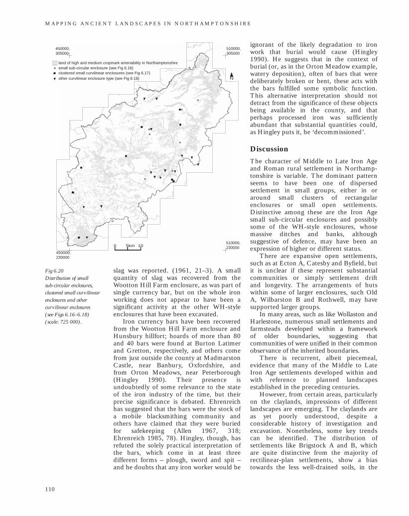
The character of Middle to Late Iron Ageand Roman rural settlement in Northamp-tonshire is variable. The dominant patternseems to have been one of dispersedsettlement in small groups, either in oraround small clusters of rectangularenclosures or small open settlements.Distinctive among these are the Iron Agesmall sub-circular enclosures and possiblysome of the WH-style enclosures, whosemassive ditches and banks, althoughsuggestive of defence, may have been anexpression of higher or different status.
There are expansive open settlements,such as at Ecton A, Catesby and Byfield, butit is unclear if these represent substantialcommunities or simply settlement drift and longevity. The arrangements of hutswithin some of larger enclosures, such OldA, Wilbarston B and Rothwell, may havesupported larger groups.
In many areas, such as like Wollaston andHarlestone, numerous small settlements andfarmsteads developed within a framework of older boundaries, suggesting thatcommunities of were unified in their commonobservance of the inherited boundaries.
There is recurrent, albeit piecemeal,evidence that many of the Middle to LateIron Age settlements developed within andwith reference to planned landscapesestablished in the preceding centuries.
However, from certain areas, particularlyon the claylands, impressions of differentlandscapes are emerging. The claylands areas yet poorly understood, despite aconsiderable history of investigation andexcavation. Nonetheless, some key trendscan be identified. The distribution ofsettlements like Brigstock A and B, whichare quite distinctive from the majority ofrectilinear-plan settlements, show a biastowards the less well-drained soils, in the
M A P P I N G A N C I E N T L A N D S C A P E S I N N O RT H A M P T O N S H I R E
110
510000,305000
450000,305000
450000,230000
510000,230000
N
0 5km 10
clustered small curvilinear enclosures (see Fig 6.17)
land of high and medium cropmark amenability in Northamptonshiresmall sub-circular enclosure (see Fig 6.16)
other curvilinear enclosure type (see Fig 6.18)
slag was reported. (1961, 21–3). A smallquantity of slag was recovered from theWootton Hill Farm enclosure, as was part ofsingle currency bar, but on the whole ironworking does not appear to have been asignificant activity at the other WH-styleenclosures that have been excavated.
Iron currency bars have been recoveredfrom the Wootton Hill Farm enclosure andHunsbury hillfort; hoards of more than 80and 40 bars were found at Burton Latimerand Gretton, respectively, and others comefrom just outside the county at MadmarstonCastle, near Banbury, Oxfordshire, and from Orton Meadows, near Peterborough(Hingley 1990). Their presence isundoubtedly of some relevance to the stateof the iron industry of the time, but theirprecise significance is debated. Ehrenreichhas suggested that the bars were the stock ofa mobile blacksmithing community andothers have claimed that they were buriedfor safekeeping (Allen 1967, 318;Ehrenreich 1985, 78). Hingley, though, hasrefuted the solely practical interpretation ofthe bars, which come in at least threedifferent forms – plough, sword and spit –and he doubts that any iron worker would be
Fig 6.20 Distribution of small sub-circular enclosures,clustered small curvilinearenclosures and othercurvilinear enclosures (see Figs 6.16–6.18)(scale: 725 000).
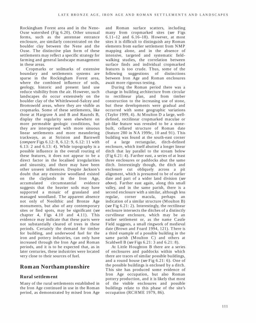
Rockingham Forest area and in the Nene-Ouse watershed (Fig 6.20). Other unusualforms, such as the antennae entranceenclosure, are similarly concentrated on theboulder clay between the Nene and theOuse. The distinctive plan form of thesesettlements may reflect a specific strategy forfarming and general landscape managementin these areas.
Cropmarks or soilmarks of extensiveboundary and settlements systems aresparse in the Rockingham Forest area,where the combined influence of soils,geology, historic and present land usereduce visibility from the air. However, suchlandscapes do occur extensively on theboulder clay of the Whittlewood-Salcey andBromswold areas, where they are visible ascropmarks. Some of these settlements, likethose at Hargrave A and B and Raunds B,display the regularity seen elsewhere onmore permeable geologic conditions, butthey are interspersed with more sinuouslinear settlements and more meanderingtrackways, as at Strixton and Barnwell(compare Figs 6.12: 8, 6.12: 9, 6.12: 11 with6.13: 2 and 6.13: 4). While topography is apossible influence in the overall routing ofthese features, it does not appear to be adirect factor in the localised irregularitiesand sinuosity, and there may have beenother unseen influences. Despite Jackson’sdoubt that any extensive woodland existedon the claylands in the Iron Age,accumulated circumstantial evidencesuggests that the heavier soils may havesupported a mosaic of grassland andmanaged woodland. The apparent absencenot only of Neolithic and Bronze Agemonuments, but also of any contemporarysites or find spots, may be significant (seechapter 4, Figs 4.10 and 4.11). Thisevidence may indicate that these parts werenot substantially cleared of trees in theseperiods. Certainly the demand for timberfor building, and underwood fuel for theiron and pottery industries, can only haveincreased through the Iron Age and Romanperiods, and it is to be expected that, as inlater centuries, these industries were locatedvery close to their sources of fuel.
Roman Northamptonshire
Rural settlementMany of the rural settlements established inthe Iron Age continued in use in the Romanperiod, as demonstrated by mixed Iron Age
and Roman surface scatters, including many from cropmarked sites (see Figs6.11–12 and 6.16–18). However, at mostsites it is difficult to distinguish any Romanelements from earlier settlement from NMPmapping alone, and in the absence ofintensive, targeted and systematic field-walking studies, the correlation betweensurface finds and individual cropmarkedfeatures is too crude. Thus, some of thefollowing suggestions of distinctionsbetween Iron Age and Roman enclosuresawait more rigorous testing.
During the Roman period there was achange in building architecture from circularto rectilinear plan, and from timberconstruction to the increasing use of stone,but these developments were gradual andoccurred with some geographic variations(Taylor 1999, 4). At Moulton D a large, well-defined, rectilinear cropmarked maculae orpit-like feature was revealed to be a stone-built, cellared structure of Roman date(feature 280 in NA 1999c, 10 and 91). Thisbuilding was found at the south-east cornerof a large rectangular, ditch-definedenclosure, which itself abutted a longer linearditch that lay parallel to the stream below(Fig 6.21: 4). Farther east, a series of at leastthree enclosures or paddocks abut the sameditch. Interestingly though, the ditch andenclosure cut obliquely across a pitalignment, which is presumed to be of earlierdate and part of a wider land division (seeabove). Farther east again, along this smallvalley, and in the same parish, there is asecond enclosure with a similar, although lessregular, corner macula, perhaps anindication of a similar structure (Moulton B)(see Fig 6.21: 2). Interestingly, the rectilinearenclosure intersects the ditches of a distinctlycurvilinear enclosure, which may be anearlier settlement or, as the name CastleField suggests, a small ringwork of medievaldate (Brown and Foard 1994, 121). There isa third example of a possible building in thesame parish (Moulton C) and others atScaldwell B (see Figs 6.21: 3 and 6.21: 8).
At Little Houghton B there are a seriesof enclosures and paddocks within whichthere are traces of similar possible buildings,and a round house (see Fig 6.21: 6). One ofthe possible buildings is enclosed by a ditch.This site has produced some evidence ofIron Age occupation, but also Romanpottery production, and it is likely that mostof the visible enclosures and possiblebuildings relate to this phase of the site’soccupation (RCHME 1979, 86).
L AT E B R O N Z E A G E , I R O N A G E A N D R O M A N S E T T L E M E N T S A N D L A N D S C A P E S
111
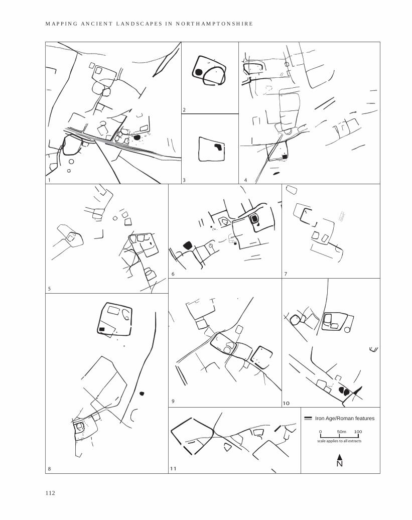
M A P P I N G A N C I E N T L A N D S C A P E S I N N O RT H A M P T O N S H I R E
112
N
50m0 100
scale applies to all extracts
Iron Age/Roman features
1
2
3 4
5
6 7
8
9
11
10
Roman pottery production is also inevidence at a settlement at Long Buckby,where the cropmarks have revealed adispersed arrangement of fields andenclosures, and of smaller rectilinearenclosures, across the hillside (see Fig 6.21:10). There is a similar poly-focal settlementless than 2km east at East Haddon (see Fig6.21: 5). Common to these, and to othersettlements at Harlestone, Wollaston andHarpole, are the small rectilinear enclosuresinserted at the edges or corners of rectilinearor polygonal enclosures. At present there areno known excavated correlates for thesefeatures, so any interpretation or dating issupposition. Certainly these enclosures aretoo large to be the actual foundationtrenches of buildings, but they may havebeen dug to separate rectangular-planbuildings of either timber or stone fromother activities and/or livestock. It may besignificant that the Wollaston examples lieso close to the villa building.
The nature of continuity at sites of IronAge settlement is undoubtedly complex. AtWakerley, during the Roman period, activitycontinued and indeed increased around the large Iron Age enclosure that lay southof the largely unenclosed settlement(Jackson and Ambrose 1978). Theenclosure was re-defined and extended, and became the focus for corn-drying,pottery firing and iron-working. An aisledbarn was built within the enclosure, butmost occupation appears to have shifted,presumably beyond the area of investigation,possibly to a nearby villa. A similar scenariowas played out at Weekley, with the additionthat a Roman Road was cut oblique acrossthe dominant alignment that had soinfluenced the development of the Late IronAge settlement (Jackson and Dix 1986–7)(see Fig 6.10: 1).
Even at Great Doddington, where thegreat ditches of the enclosure were infilled inthe Roman period, the presence ofRomano-British debris in the ditch fillsindicates the likelihood of contemporarysettlement near by (Windell 1981).
Villas
At the time of writing there were 93 knownor suspected villas in the county. Much ofthe evidence has been collated from theexisting records and publications in acountry-wide survey by Scott (1980,139–49). The location information in thispublication is very coarse, and so wherever
possible SMR data have been used to moreaccurately locate the known sites for thisdiscussion. There may be an over-estimation of the number of villas becauseinterpretation is based solely on surfacefinds of building materials.
This project has recorded possibleevidence for 34 of these villas. In 22 casesthe foundations or robber trenches offormer buildings were visible from the air,and in four of those they were surroundedby a large enclosure or compound (Fig6.22). The evidence for the villa structuresthemselves indicates considerable variabilityin architecture and size. Compounds,enclosures or ditches have been recorded atthe sites of the other 11, but it is possiblethat these relate to other periods ofoccupation on the same site (Fig 6.23). The enclosures recorded at Thurning,Nassington B and Sulgrave B may also havebeen built around villas, but no evidence ofany internal structures at these sites has yetcome to light. Taylor has noted thatenclosure of villa sites occurred relativelylate (Taylor 1999, 3).
The known and potential villas aredensely concentrated along the River Neneand the valleys of minor tributaries, inplaces the distance between neighbouringsites is no more that 1km to 2km, althoughof course not all were necessarily con-temporaneous (Fig 6.24). There is a muchmore sparse distribution on the Lias clays inthe north and west of the county, but thereis a considerable presence on the boulderclays of both the Rockingham Forest areaand the Nene-Ouse watershed. Theconcentration in the north-eastern part ofRockingham Forest may, in part, reflect theproximity of the major Roman town ofDurobrivae, while management of thesubstantial iron industry by villa estatesmight also have played its part in generatingthis distribution.
Roman stone buildings of circular planhave been excavated at Ringstead, Overstoneand Thorplands, and are visible at the villasites of Cotterstock, Great Doddington,Stoke Bruene and Blather-wycke, and at the small town of Titchmarsh. The nature of the evidence at Thorplands, a settlement of ‘reasonable prosperity’ engaged in animal husbandry and small-scale ironworking, suggests that the circular stonebuilding was not in itself a dwelling of highstatus (Hunter and Mynard 1977, 108). In the other examples, the spatial relationship between the circular buildings
L AT E B R O N Z E A G E , I R O N A G E A N D R O M A N S E T T L E M E N T S A N D L A N D S C A P E S
113
Fig 6.21 (opposite)Possible Roman elementsamong Iron Age andRoman rural settlement: 1 Harlestone; 2 Moulton B; 3 Moulton C; 4 Moulton D; 5 East Haddon; 6 Little Houghton B; 7 Wollaston; 8 Scaldwell B; 9 Harpole; 10 Long Buckby; 11 Holdenby) (scale 1:5 000).
M A P P I N G A N C I E N T L A N D S C A P E S I N N O RT H A M P T O N S H I R E
114
25m0 50
scale applies to all extracts, photograph not to scale
1 2 3
4 5 6
7
8
excavated stonework
limit of excavation
N25m0 50
scale applies to all extracts, photograph not to scale
Iron Age/Roman features(extracts 1-5 & 8)
Fig 6.22 (above)Villa structures: 1 Wollaston; 2 Little Addington B; 3 Fotheringhay B;
Fig 6.23 (opposite)Large rectilinear enclosuresat known and possiblevilla sites (SMR; Scott1980; D Hall pers comm): 1 Barnwell;
4 Wakerley; 5 Great Doddington; 6 Stanwick; 7 Cotterstock; 8 Blatherwycke) (scale 1:2 500).
2 Hemington; 3 Thurning; 4 King’s Cliffe; 5 Nassington B; 6 Mears Ashby B; 7 Glapthorn;
8 Sulgrave B; 9 Clopton; 10 Thenford; 11 Higham Ferrers) (scale 1:5 000).
and main villa ranges is a close one, andappears to be the results of contemporaneityrather than succession. The possibility thatsome were temples in the manner of theBrigstock shrines has already been mooted(Williams 1976, 112).
Nucleated settlements
Excavations of the villas and theirimmediate environs at Higham Ferrers,Stanwick and Cosgrove have revealednucleation of Roman settlement on these
L AT E B R O N Z E A G E , I R O N A G E A N D R O M A N S E T T L E M E N T S A N D L A N D S C A P E S
115
1 2 3
5 6 7 8
4
9 10 11
N50m0 100
scale applies to all extracts
approximate location of villa structure
Roman findspot or scatter
Iron Age/Roman features
M A P P I N G A N C I E N T L A N D S C A P E S I N N O RT H A M P T O N S H I R E
116
Fig 6.24 Distribution of Romantowns, nucleated settlements,villas and the layout of theroad network (for roads see
to Cave’s Inn (TRIPONTIUM)
to Bicester
to Godmanchester
(DUROVIGNUTUM)
to Leicester
(RATAE CORIELTAVORUM)
to Olney
510000,305000
450000,305000
450000,230000
510000,230000
N
2
1
3 4
5
6
8
9
7
10
11
17
15
14
13
16
12
land of high and medium cropmark amenability
Roman town
possible Roman nucleated settlement
Roman villa with NMP evidence
Roman villa from other sources
known and possible Roman road alignments
NMP evidence for other possible Roman roads
NMP evidence for RCHME Roman road alignments
0 5km 10
A
B
C D
E
F
G
H
I
J
K
18
Ermine Street
to
MAGIOVINIUM
Table 1): 1 Blacklands, KingsSutton; 2 Brackley; 3 BlackGrounds, Chipping Warden;4 Towcester; 5 Whilton Lodge(Bannaventa); 6 Duston;
7 Little Houghton; 8 Irchester; 9 LittleHarrowden; 10 HighamFerrers; 11 Stanwick,Raunds; 12 Kettering;
13 Woodford Huxloe; 14 Titchmarsh (town); 15 north of Titchmarshvillage (?nucleatedsettlement); 16 Ashton;
17 Laxton; 18 Waternewton(Durobrivae) (D Hall perscomm; RCHME 1975, 1979,1981, 1985; Scott 1980;SMR) (scale 1:400 000).
high-status settlements. Although the villastructures at Higham Ferrers and Stanwickwere visible on air photographs, there waslittle to distinguish the surrounding featuresfrom the more common fragments of LateIron Age or Roman rural settlement.
A combination of surface finds andcropmark evidence around the villas atBlack Grounds, in Chipping Warden, andWoodford Huxloe, in Woodford, suggeststhat they may also have been the focus ofassociated settlements. Large quantities ofRoman finds have been recovered from thearea around Black Grounds, indicating thatit was a larger settlement than the rathersparse cropmarks suggest (RCHME 1982,29). South-west of the second Woodfordvilla there is a linear arrangement of tightlyclustered enclosures, boundaries and pitsvisible over an area of approximately 4.5ha.
Complex cropmarks at Little Harrowdenand north of Titchmarsh village mayrepresent similar concentrations ofpopulation, but there is no supportingevidence from surface finds of the status oreven the likely date of these remains. Littleis known about the complex buildings andenclosures at Little Harrowden. These weremapped from infra-red photography and theprints were not available for review at thetime of writing. However, the example northof Titchmarsh village is much clearer andmay be associated with a possible templesite, which is 0.5km to the south-west, in thedirection of the small town at Titchmarsh(see below).
RCHME suggested that the crop marks recorded at Little Houghton B (see Fig 6.21: 6) were part of a ‘semi-urbanised or at least very densely occupiedsettlement’ (1979, xiv), but this interp-retation appears not to be supported by theNMP evidence, the surface scatter orrelated evidence in the SMR. Excavation ofa large cemetery and buildings attest to thepresence of a nucleated settlement at the industrial-scale iron works at Laxton,but there is no evidence for this visible onthe air photographs consulted (Jackson1998–9, 159).
Small towns
Aerial photography has revealed details of theplan and layouts of the Roman small towns atWhilton Lodge (Bannaventa), Irchester,Titchmarsh and Ashton, and some featuresat Blacklands at King’s Sutton (Figs 6.25 and6.26). No information was recorded from the
air photographs for the small towns ofBrackley, Duston, Towcester (Lactodorum)and Kettering. This is because Duston andKettering were largely quarried and built overin the late 19th and early 20th centuries, andTowcester’s Roman levels are maskedbecause the site was refortified as a LateSaxon burh and developed into a medievaland modern town.
At Bannaventa air photographs haverevealed the plan of an expansive settlementthat developed at the junction betweenWatling Street and a spur road that led to thesmall town at Duston (see Fig 6.26: 2). Onlythe western side of the town is well defined,whereas the section east of Watling Street,which was partly quarried in the 1970s, is barely visible. The dominant features are the ditches of the town’s defences, which appear to cut across other elements.
L AT E B R O N Z E A G E , I R O N A G E A N D R O M A N S E T T L E M E N T S A N D L A N D S C A P E S
117
Fig 6.25 View of cropmarks andparchmarks at IrchesterRoman town, looking east(NCC photographSP9166/307 10th July1994 NCC copyright).
Possible buildings have been detected alongthe road some 650m south of the town.
The majority of the town at Irchester isvisible on air photos in exceptional detail(see Fig 6.25). The town core occupies amodern field unit of some 7ha with a highdensity of buildings, enclosures and streets,but other more dispersed elements arevisible in neighbouring fields up to 300maway. The town appears to have beenplanned along a series of streets branchingfrom the main north–south road, althoughsome elements may predate the final roadlayout. More than 200 possible buildings orstructures are visible within the town. Roadscan be clearly seen leaving the settlementheading west to Duston, north to Ketteringvia a causeway across the floodplain, andeast to Titchmarsh. A fourth road is knownfrom fieldwork to extend southward toDungee Corner and possibly beyond toOlney in Buckinghamshire.
The visible remains at Titchmarsh arerather more fragmentary and dominated bya complex, dendritic pattern of roads (seeFig 6.26: 1). A handful of buildings frontthe road that leads to Leicester, a roadvisible 300m to the north-west as acauseway crossing the valley floor. Less than200m south-west, a second concentration ofstructures is visible, focussed on thejunction of several minor roads. These
structures are arranged within a rectangularcompound and may represent the remainsof a mansio or perhaps a temple complex (JTaylor pers comm); 100m to the south-westthe air photographs have recorded four sidesof a pentagonal or hexagonal structure:another possible temple.
The town of Ashton is located close tothe river but over 1.5km from the presumedline of the Roman road that ran betweenWaternewton (Durobrivae) and Titchmarsh.Unlike Titchmarsh and Irchester, there arefew structural remains visible on the airphotographs at this site, the principleelements being large, superimposedrectilinear enclosures, sub-divided by anetwork of metalled roads, and with a highdensity of large pits (see Fig 6.26: 4).However, extensive excavation hasdemonstrated buildings lining the mainnorth-east–south-west road, immediatelysouth-east of the cropmarks mapped here.
At Ashton, Titchmarsh and probablyIrchester, the plan form thus appears to bebased upon a main through-road lined withstructures, but with the majority of thesettlement focussed around a loop roadrunning off the main route and back again.In the case of Irchester, only this core areawas enclosed by defences.
By contrast the visible elements atBlacklands, Kings Sutton, in the far south-west of the county do not distinguishthemselves as the remains of a town andcould perhaps be mistaken for a smallerroad-side settlement, although thedistinction between the two may be largelyartificial in any case (J Taylor pers comm.)(see Fig 6.25: 4).
Roman roads
This project has recorded more then 50sections of possible road from airphotographs, some as earthworks, butmainly as cropmarks, parchmarks or soilmarks. The majority are undated and, although many are believed to beRoman, few can be securely attributed tothis period. Some, such as the embank-ments at Laxton and Fineshade, can bedemonstrated to be of post-medieval date by reference to contemporary maps (AHRC Project digital archive). It has not been possible to undertake detailedhistoric map work of potential road-like features as part of the NMP, so adetailed reconstruction of the Romannetwork must await the analysis phase
M A P P I N G A N C I E N T L A N D S C A P E S I N N O RT H A M P T O N S H I R E
118
Fig 6.26 Roman towns: 1 Titchmarsh; 2 Blacklands, Kings Sutton; 3 Ashton; 4 Whilton Lodge(Bannaventa) (scale 1:10 000).
1 2
4 3
N100m0 200
scale applies to all extracts
Iron Age/Roman features to Leicester
to Cave’s Inn
to Towcester
to Godmanchester
to Duston
to Brackley?
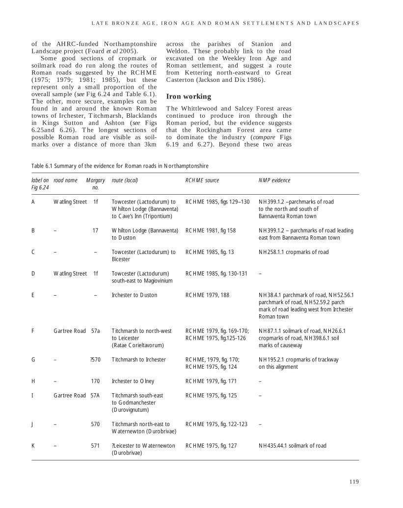
of the AHRC-funded NorthamptonshireLandscape project (Foard et al 2005).
Some good sections of cropmark orsoilmark road do run along the routes ofRoman roads suggested by the RCHME(1975; 1979; 1981; 1985), but theserepresent only a small proportion of theoverall sample (see Fig 6.24 and Table 6.1).The other, more secure, examples can befound in and around the known Romantowns of Irchester, Titchmarsh, Blacklandsin Kings Sutton and Ashton (see Figs6.25and 6.26). The longest sections ofpossible Roman road are visible as soil-marks over a distance of more than 3km
across the parishes of Stanion and Weldon. These probably link to the roadexcavated on the Weekley Iron Age andRoman settlement, and suggest a route from Kettering north-eastward to GreatCasterton (Jackson and Dix 1986).
Iron working
The Whittlewood and Salcey Forest areascontinued to produce iron through theRoman period, but the evidence suggeststhat the Rockingham Forest area came to dominate the industry (compare Figs 6.19 and 6.27). Beyond these two areas
L AT E B R O N Z E A G E , I R O N A G E A N D R O M A N S E T T L E M E N T S A N D L A N D S C A P E S
119
Table 6.1 Summary of the evidence for Roman roads in Northamptonshire
label on road name Margary route (local) RCHME source NMP evidenceFig 6.24 no.
A Watling Street 1f Towcester (Lactodurum) to RCHME 1985, figs 129–130 NH399.1.2 –parchmarks of road Whilton Lodge (Bannaventa) to the north and south of to Cave’s Inn (Tripontium) Bannaventa Roman town
B – 17 Whilton Lodge (Bannaventa) RCHME 1981, fig 158 NH399.1.2 – parchmarks of road leading to Duston east from Bannaventa Roman town
C – – Towcester (Lactodurum) to RCHME 1985, fig. 13 NH258.1.1 cropmarks of roadBicester
D Watling Street 1f Towcester (Lactodurum) RCHME 1985, fig. 130-131 –south-east to Magiovinium
E – – Irchester to Duston RCHME 1979, 188 NH38.4.1 parchmark of road, NH52.56.1 parchmark of road, NH52.59.2 parch mark of road leading west from Irchester Roman town
F Gartree Road 57a Titchmarsh to north-west RCHME 1979, fig. 169-170; NH87.1.1 soilmark of road, NH26.6.1 to Leicester RCHME 1975, fig.125-126 cropmarks of road, NH398.6.1 soil (Ratae Corieltavorum) marks of causeway
G – ?570 Titchmarsh to Irchester RCHME, 1979, fig. 170; NH195.2.1 cropmarks of trackway RCHME 1975, fig. 124 on this alignment
H – 170 Irchester to Olney RCHME 1979, fig. 171 –
I Gartree Road 57A Titchmarsh south-east RCHME 1975, fig. 125 –to Godmanchester (Durovignutum)
J – 570 Titchmarsh north-east to RCHME 1975, fig. 122-123 –Waternewton (Durobrivae)
K – 571 ?Leicester to Waternewton RCHME 1975, fig. 127 NH435.44.1 soilmark of road(Durobrivae)
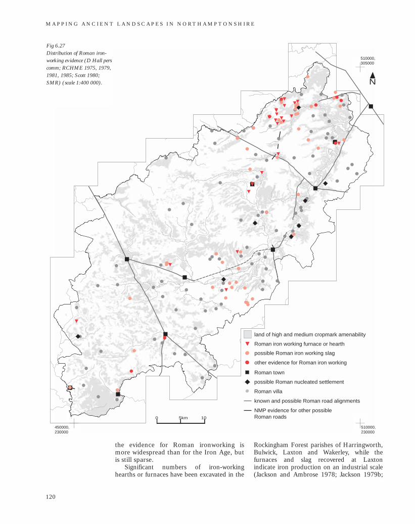
510000,305000
450000,305000
450000,230000
510000,230000
N
land of high and medium cropmark amenability
Roman iron working furnace or hearth
possible Roman iron working slag
Roman town
Roman villa
known and possible Roman road alignments
NMP evidence for other possible Roman roads
possible Roman nucleated settlement
other evidence for Roman iron working
0 5km 10
the evidence for Roman ironworking is more widespread than for the Iron Age, butis still sparse.
Significant numbers of iron-workinghearths or furnaces have been excavated in the
Rockingham Forest parishes of Harringworth,Bulwick, Laxton and Wakerley, while thefurnaces and slag recovered at Laxton indicate iron production on an industrial scale(Jackson and Ambrose 1978; Jackson 1979b;
M A P P I N G A N C I E N T L A N D S C A P E S I N N O RT H A M P T O N S H I R E
120
Fig 6.27Distribution of Roman iron-working evidence (D Hall perscomm; RCHME 1975, 1979,1981, 1985; Scott 1980;SMR) (scale 1:400 000).
Jackson 1981; Jackson 1998–9;). Finds of slagare also common elsewhere in these andneighbouring parishes. In this area the evidencefor iron working is strung along the sides of the minor valleys, where the thin bands ofnodular ironstone are accessible below theUpper Estuarine Series formations. The upperground is covered with a blanket of boulderclay, which again is the most likely source of thecharcoal fuel. As the demand for ironincreased, so must the need for intensivemanagement of the woodland to support anexpanding charcoal industry.
Evidence for charcoal-burning hearths iscommon in the Rockingham Forest area,and although it is accepted that the majorityrelate to medieval or later production,among these there may be earlier, Iron Ageand Roman survivors, for the methods ofproduction were probably similar (seechapter 7; Foard 2001a, 85).
Evidence for Roman period iron workinghas been recovered from the small towns ofKettering and Ashton, both on the fringes ofthe Rockingham Forest area, and fromBlacklands, King’s Sutton, in the far south-westof the county. Kettering and Ashton are part ofa wider group of small towns in Leicestershire,Rutland and south Lincolnshire that wereassociated with Roman iron production andworking (Schrufer-Kolb 1999). Condron hassuggested that Ashton was a specialisedsmithing centre that could have out-suppliedthe local demand (1997, 10).
There is evidence of iron working in oraround several of the Rockingham Forestvillas: Great Weldon, Cottingham, Gretton,Harringworth, Blatherwyke and KingsCliffe. Ironworking slag has also beenrecovered from villas at Brafield, BurtonLatimer, Brackley, Harpole and Thorp-lands, and an iron-smelting furnace wasfound at the villa at Piddington. Whereasthe evidence from some sites, such as GreatWeldon, is securely stratified, for most sitesthe finds are from field-walking and theassociation does not therefore prove thatiron-working activity was contemporarywith the occupation of the villas, althoughthis is likely.
Iron working does not appear to havebeen a major activity within non-villa rural settlements of the period. There isrelatively little correlation between thedistribution of the highly numerouscropmarked enclosure and complexes andthat of iron-working evidence. This may bebecause investigations, particularly those ofan antiquarian nature, were biased towards
the villas or because resolution of find-spot recording is too coarse. However, it is interesting to note that there was noknown nearby settlement to the furnacesdiscovered at Bulwick and Gretton, and that those at Wakerley were not directlyassociated with any contemporary domesticoccupation. Indeed at Wakerley, while kilnsfor corn drying and pottery firing lay mainlywithin the Roman enclosure, the smeltinghearths were constructed outside theenclosure ditch (Jackson and Ambrose1978, figs 1 and 25).
Many of the Roman iron-working sites inthe Rockingham Forest area are well placedto exploit the road network that providedlinks to the major centres of populationwithin the county and large urban centresbeyond, particularly Durobrivae.
DiscussionAlthough there is considerable evidence forcontinuity of Iron Age settlements into theRoman period this was often accompaniedby a change in use or adjustment of thesettlement layout. At Harlestone andHoldenby possible Roman enclosures werebuilt slightly against the grain of the earlier pit alignments, as was observed atMoulton D (see Fig 6.21: 1, 6.21: 11 and6.21: 4). It is worth reiterating that most pitalignments in the close vicinity of Iron Agesettlement appear to have been re-cut byditches. That these examples survived aspits and were not re-cut may suggest thatthey were beyond the focus of earliersettlement; by the end of the Iron Age andbeginning of Roman period their presencemay have been undetectable. Excavationshowed that the enclosure around the villaat Wootton Fields cut across a pit alignmentand the remains of unenclosed settlement(NA 1999b).
Excavations at Ashley, Weekley,Ringstead, and Wakerley have suggestedthat areas of older settlement werefrequently re-used for a range of craft,industry and agricultural activities, but thatthe site of the main villa range was slightlyremoved (Jackson and Ambrose 1978;Jackson 1980; Taylor and Dix 1980; Jacksonand Dix 1986–7). A localised shift ofsettlement was also noted at Wollaston(Meadows 1995). While this may reflect theincreasing status of the occupants of theoriginal settlement, it might alternativelyreflect the displacement of the earlierinhabitants.
L AT E B R O N Z E A G E , I R O N A G E A N D R O M A N S E T T L E M E N T S A N D L A N D S C A P E S
121
Dix and Jackson considered theproximity of villa sites to the defendedenclosures at Wootton Hill Farm andWeekley to be indicative of the growingstatus of the latter (1989, 164). Certainlythe WH-style enclosures at Blackthorn andGreat Doddington are also within 700m of sites of possible Roman buildings, butgiven the relative density of villas in theareas of these enclosures, such longer-distance correlations are perhaps betterattributed to coincidence.
ConclusionAlthough the aerial photographic evidencefor the Iron Age and Roman landscape is extensive and widespread, despite theefforts of carefully-targeted reconnaissanceand intensive analysis the recovered patternis still highly fragmented. It may be that this reflects the reality of the North-amptonshire landscape during this period,and that it lacked the type of contiguous
articulated landscapes seen in other parts ofEngland, as on the North Nottinghamshiresandstones and the Yorkshire Wolds.Through the various datasets available tothis study it has been possible to definewhere cropmark and soilmark evidencemight be present, and hence where thepresence or absence is significant. The nextstage should be to identify those areas wheresurvival might be expected. Paradoxicallythese will probably be the areas wherevisibility from the air is acknowledged to bepoor: the unploughed zones, longstandingwoodland and under alluvial deposits on thevalley floors. Once mapped, these zonesmight be prioritised for other intrusive andnon-intrusive invest-igations, which could beeither research-led or achieved through theplanning process in response to developmentthreats. One clear path for investigation, as discussed earlier, would be for asystematic, intensive field-walking prog-ramme to complement the data and to testand elaborate the analysis presented here.
M A P P I N G A N C I E N T L A N D S C A P E S I N N O RT H A M P T O N S H I R E
122
Panel 6.1 Pit alignmentsThe pit alignments excavated in Englandand Scotland have yielded a broad range ofdates, from the Neolithic to the Romanperiod. It has been suggested that whilealignments of oval-plan pits may have had along period of currency the morerectangular or oblong-shaped features,characterised by straight sides and flatbottoms are often Late Bronze Age toMiddle Iron Age in date (MPP 1989).
Both forms are present inNorthamptonshire. Pits of variable butpredominantly round or oval shape were cutalong the northern edge of the Briar Hillcausewayed enclosure and, althoughundated, were considered by Bamford to beof possible Neolithic date (1985, 49).Approximately 500m to the south-east,farther up Briar Hill, there were two close-set alignments of small, round- to oval-planpits, which had subsequently been cut bysubstantially larger rectilinear pits along thesame path. Again there was no datingevidence, but it was suggested as a multi-phase part of the surrounding Iron Age landscape (Jackson 1974, 24). Pitsexcavated at Grendon, Gretton andWollaston, Ringstead, like the laterboundary at Briar Hill, are characterised by
their regular oblong shape, size and spacing.In 1974 there were 25 pit alignments
known in the county, mainly from aerialphotography, but very few had beenexcavated (Jackson 1974, 44, fig 1). Threedecades later the project has mapped some144 pit alignments as either single featuresor elements of more complex systems, whilea rapid survey of mapping from laterphotography not yet integrated into theNMP dataset has revealed yet more, giving atotal of more than 36km of pit alignments inthe county. The geographic range has alsobeen extended with some areas previouslydevoid of evidence, such as that betweenAldwincle and Grendon, now well endowedwith examples (see Fig 6.2; cf Jackson1974). The majority of them, in partprobably owing to the biases of recovery, lieon permeable geology. They are mostnumerous on Northampton Sand andIronstone (44 examples, averaging 1 per 4.2km2) and Great Ooolite Limestone (26; 1per 4 km2), but the density is highest on theterrace gravels (1 per 2.6 km2). Surprisinglynearly a quarter of all pit alignmentsappeared or extended onto less permeablegeologies, mainly the Upper Lias Clay, andalthough in some cases the resolution of thegeological data on which these analyses arebased may be too coarse, excavation atCrick suggests that pit alignments are
L AT E B R O N Z E A G E , I R O N A G E A N D R O M A N S E T T L E M E N T S A N D L A N D S C A P E S
123
indeed present in some areas of clay soils(Kidd 1999, 5).
It was recognised early in the project thatthe general shape of each pit was potentiallysignificant and, in a departure fromstandard NMP recording practice, the pitshape was represented in the mapping. Overthree-quarters of the alignments mappedconsist of pits that are oblong orrectangular, with the remainder unknown or possibly round. The oblong orrectangular pits are generally less than 2.5mlong and less than 1.8m wide, although theycan range from rather elongated slots tonear square features. The longer axis of eachpit is always in line with the overallorientation of the alignment and the spaces
between pits are rarely longer than the pitsthemselves. The alignments of oblong pits are characterised by a high degree ofregularity in pit size, shape and spacing,although many make abrupt changes indirect or take curving paths; and some showpossible groupings of pits and minorrealignments between groups that may beindications of gangwork. These character-istics are consistent with Late Bronze Age to Early Iron Age excavated examples and thus they are also assumed to be of thisdate. However, excavation has repeatedlydemonstrated that these boundaries aremore complex in form and developmentthan the simple cropmark evidence would suggest.
Panel 6.2 An Overview of the Evidencefor Iron Working in the IronAge and Roman Period
Iron working in this period comprised twodistinct processes: smelting and smithing.Iron first had to be separated from theparent ore. The furnace technologydeveloped during the Iron Age and Romanperiod was insufficient to take iron to itsmelting point of 1534°C. Without achievingmelting point, impurities in iron are lessreadily expelled and richer ores arerequired, but this was not necessarilydetrimental to the finished object’s function(Salter and Ehrenreich 1984, 146). Then,unlike bronze, which could be cast inmoulds, objects in iron had to be forged andcomplex items rivetted or hammer welded(Salter and Ehrenreich 1984).
The raw materials for iron smelting andsmithing were readily available in Iron Ageand Roman Northamptonshire. TheNorthampton Sand and Ironstone outcropswidely in central Northamptonshire, but,although exploited on a massive scale in the19th and 20th centuries, it is not clear ifthese ores were sufficiently rich forsuccessful Iron Age and Roman smelting.The hardpan formed in sandstone bychemical leaching of the iron may haveprovided a more concentrated deposit(Salter and Ehrenreich 1984). Analternative source is the narrow band ofnodular ironstone that outcrops beneath theUpper Estuarine Series in the north-east of
the county, which can also be reached byquarrying. Evidence for iron ore extractionof this period is rather scarce in theexcavation record and all but absent in theNMP record. At Great Oakley, scoopsthought to be prospecting for ironstoneerratics in the boulder clay may have beenassociated with two Early Iron Agestructures (Jackson 1982), and at BulwickRoman quarry pits would have accessed theunderlying nodular ore (Jackson 1979b).There are many small hollows and pitsvisible on the air photographs, but it wouldbe near impossible to distinguish those thatwere excavated for other purposes. Bellamyet al noted an association between thenaturally-occurring pits in the UpperEstuarine Series along the edge of theexposed Lincolnshire Limestone and thepresence of slag finds from all periods(2000, 108). They suggest that the nodularironstone may have been quarried along thehorizontal beds from where it was exposedin the walls of these natural shafts (Bellamyet al 2000, fig. 3). While this formationsurvives best in woodland, the NMP hasrecorded a narrow swathe of swallow holesas earthworks and soilmarks across theparishes of Harringworth, Laxton andDuddington. These are in an area rich withthe evidence of early iron working, not leastthe industrial-scale complex of Romanfurnaces and slag heaps at Laxton (Jackson1998–9), less than 1km to the south-east. Itseems unlikely that, if nodular ironstonebeds were exposed in these shafts, such aneasily accessible and rich source would nothave been exploited to supply this
burgeoning industry. Clay for furnaceconstruction was widely available, and againits extraction leaves little identifiable trace.
The third major ingredient for ironsmelting and other working is fuel. Salterand Ehrenreich estimate that, in theconditions obtained by Iron Age andRoman smelting, 90kg of fuel was requiredto process 20kg of ore into 1kg of iron(1984, 146–7). Moreover, although woodwas sufficient for ore roasting, the hotterprocesses would have required charcoal. On Cleere’s estimations the ratio of woodinput to charcoal output is 7:1 (1976, 240).In terms of the economics of resourceavailability, then, the supply of prepared fuel would appear to be a significant
consideration in the siting of iron smeltingactivity. Importantly, to give optimumairflow the charcoal particle size is crucial,and best obtained from wood of managed,that is coppiced, trees, where this factorcould be controlled by the duration leftbetween cropping (Salter and Ehrenreich1984, 149). Managed woodland of thisperiod is almost invisible in thearchaeological record, but must have been asignificant element of the Iron Age andRoman landscapes.
While the sites of iron production arerarely identifiable from the air, the impactthe developing iron had on the landscape as a consequence of improved tooltechnology is inescapable.
M A P P I N G A N C I E N T L A N D S C A P E S I N N O RT H A M P T O N S H I R E
124
125
7The contribution of aerial
photography to Anglo-Saxon studiesby Glenn Foard and Alison Deegan
Introduction
In the study of the post-Roman landscape ofNorthamptonshire, archaeological evidenceis complemented by documentary and place-name evidence, although even by the LateAnglo-Saxon period this is still a minorcontribution compared to that fromarchaeological investigations. Of the latter,aerial archaeology is, however, perceived tohave a very limited contribution to thisperiod. The Lincolnshire NMP projectyielded little positive evidence of Anglo-Saxon settlement, other than that excavatedat Riby Crossroads (Steedman 1994;Boutwood 1998, 58), while an earlier projectin the Yorkshire Wolds identified just a fewsites where groups of pits were interpreted aspossible sunken-featured buildings (SFBs),and by association the groups of curvilinearenclosures in which they are found, as thepossible remains of Anglo-Saxon settlement(Stoertz 1997, 17 and 59). Of the county-based resource assessments that informed theRegional Research Framework (RRF) for theEast Midlands, only the Northamptonshireassessment discussed the contribution ofaerial photography to the Anglo-Saxonresource (Foard 2001b, 1, 6, 9, 27), whilemention of this remote-sensing technique isentirely absent from the main regionaloverview RRF chapter on the Anglo-Saxonperiod (Vince 2004). However, sites asdiverse as the palace at Yeavering, North-umberland and the rural farmstead atCatholme, Staffordshire, both of which wererecorded by air photographs, demonstratethat aerial photography does have a part toplay in the identification and understandingof some Anglo-Saxon settlement (Hope-Taylor 1977; Losco-Bradley et al 2002). Thepresent chapter assesses the degree to whichthis potential has been realised by aerialarchaeology in Northamptonshire and whatavenues there may be for further exploitationof this dataset.
The archaeology of the Anglo-Saxonperiod in Northamptonshire has been
subject to intensive study over the last 30years: through field-walking surveys; inlarge-scale research projects involving fieldsurvey and excavation at Raunds and in theWhittlewood area; in other large- and small-scale excavations and related fieldworkrequired through the planning process; aswell as through analysis of place-names andof the very slim documentary record of theperiod and through back projection fromevidence in post-Norman conquest sources.The archaeological investigations have beenparticularly effective because there isreasonably good ceramic evidence in theregion throughout most of the 5th to 11thcenturies, even if there are some problemswith the detail of dating within thisevidence. As a result, unlike many othercounties, there is extensive stratified andsurface scatter evidence against which theaerial archaeology evidence can be assessed(Brown and Foard 1998; Brown and Foard2004). The county’s aerial reconnaissanceprogramme since 1976, and the NMPproject, were also conducted with the issuesof Anglo-Saxon activity clearly in mind.Northamptonshire is thus an ideal areawithin which to assess the potentialcontribution of aerial archaeology to theunderstanding of the Anglo-Saxon period.
Evidence from archaeological surveyField-walking has identified by far thelargest number of sites of Anglo-Saxonsettlement in the county (Brown and Foard2004). The sites excavated at Brixworth,Upton and Higham Ferrers were foundbeneath scatters of Anglo-Saxon artefacts.Shaw observed that the Brixworth andUpton scatters were both relatively meagre:the former produced just 37 sherds andthose were recovered over a number of visits(Shaw 1993–4). The quantity of scattersand find spots producing Anglo-Saxonmaterial is considerable and well distributedacross the county. Even if some of these
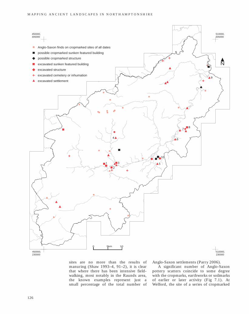
510000,305000
450000,305000
450000,230000
510000,230000
N
1
6
8
Anglo-Saxon finds on cropmarked sites of all dates
possible cropmarked sunken featured building
possible cropmarked structure
excavated sunken featured building
excavated structure
excavated cemetery or inhumation
excavated settlement
0 5km 10
7
3
2
4
5
9
10
sites are no more than the results ofmanuring (Shaw 1993–4, 91–2), it is clearthat where there has been intensive field-walking, most notably in the Raunds area,the known examples represent just a small percentage of the total number of
Anglo-Saxon settlements (Parry 2006).A significant number of Anglo-Saxon
pottery scatters coincide to some degreewith the cropmarks, earthworks or soilmarksof earlier or later activity (Fig 7.1). AtWelford, the site of a series of cropmarked
M A P P I N G A N C I E N T L A N D S C A P E S I N N O RT H A M P T O N S H I R E
126
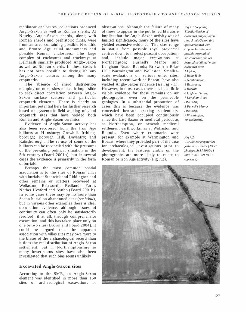
rectilinear enclosures, collections producedAnglo-Saxon as well as Roman sherds. AtNaseby Anglo-Saxon sherds, along withRoman sherds and prehistoric flints, werefrom an area containing possible Neolithicand Bronze Age ritual monuments andpossible Roman enclosures. The largecomplex of enclosures and trackways atKelmarsh similarly produced Anglo-Saxonas well as Roman sherds. In these cases ithas not been possible to distinguish anyAnglo-Saxon features among the manycropmarks.
The absence of sherd distributionmapping on most sites makes it impossibleto seek direct correlation between Anglo-Saxon surface scatters and particularcropmark elements. There is clearly animportant potential here for further researchbased on systematic field-walking of goodcropmark sites that have yielded bothRoman and Anglo-Saxon ceramics.
Evidence of Anglo-Saxon activity hasalso been recovered from the Iron Agehillforts at Hunsbury; Crowhill, Irthling-borough; Borough Hill, Daventry; andRainsborough. The re-use of some of thehillforts can be reconciled with the pressuresof the prevailing political situation in the 5th century (Foard 2001b), but in severalcases the evidence is primarily in the form of burials.
Perhaps the most common spatialassociation is to the sites of Roman villaswith burials at Stanwick and Piddington andother remains or scatters recovered atWollaston, Brixworth, Redlands Farm,Nether Heyford and Aynho (Foard 2001b).In some cases these may be no more thanSaxon burial on abandoned sites (see below),but in various other examples there is clearoccupation evidence, although issues ofcontinuity can often only be satisfactorilyresolved, if at all, through comprehensiveexcavation, and this has taken place only onone or two sites (Brown and Foard 2004). Itcould be argued that the apparentassociation with villas sites may owe more tothe biases of the archaeological record thanit does the real distribution of Anglo-Saxonsettlement, but in Northamptonshire somany lower-status sites have also beeninvestigated that such bias seems unlikely.
Excavated Anglo-Saxon sites
According to the SMR, an Anglo-Saxonelement was identified in more than 150sites of archaeological excavations or
observations. Although the failure of manyof these to appear in the published literatureimplies that the Anglo-Saxon activity was oflimited significance, many of the sites haveyielded extensive evidence. The sites rangein status from possible royal provincialcentres down to modest peasant occupation,and, include major excavations atNorthampton; Furnell’s Manor andLangham Road, Raunds; Brixworth; BriarHill; Warmington and Wollaston. Smaller-scale evaluations on various other sites,including recent work at Bozeat, have alsoyielded Anglo-Saxon evidence (see Fig 7.1).However, in most cases there has been littlevisible evidence for these remains on airphotographs, even on the permeablegeologies. In a substantial proportion ofcases this is because the evidence wasconcealed beneath existing settlements,which have been occupied continuouslysince the Late Saxon or medieval period, asat Northampton, or beneath medievalsettlement earthworks, as at Wollaston andRaunds. Even where cropmarks werepresent, for example at Warmington andBozeat, where they provided part of the casefor archaeological investigations prior todevelopment, the features visible on thephotographs are more likely to relate toRoman or Iron Age activity (Fig 7.2).
T H E C O N T R I B U T I O N O F A E R I A L P H O T O G R A P H Y T O A N G L O - S A X O N S T U D I E S
127
Fig 7.1 (opposite)The distribution ofexcavated Anglo-Saxonsites, Anglo-Saxon findspots associated withcropmarked sites andpossible cropmarkedstructures and sunkenfeatured buildings (mainexcavated sites: 1 Upton; 2 Briar Hill; 3 Northampton; 4 Brixworth; 5 Bozeat; 6 Higham Ferrers; 7 Langham Road(Raunds); 8 Furnell’s Manor(Raunds); 9 Warmington; 10 Wollaston).
Fig 7.2 Curvilinear cropmarkedfeatures at Bozeat (NCCphotograph SP8960/1130th June 1989 NCCcopyright).
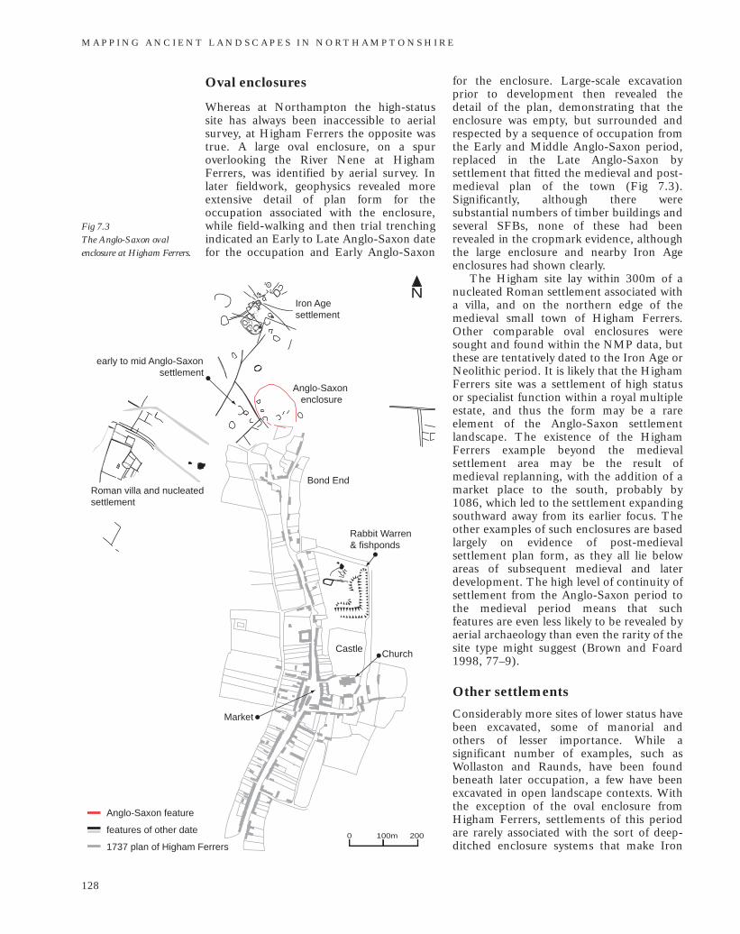
Oval enclosures
Whereas at Northampton the high-statussite has always been inaccessible to aerialsurvey, at Higham Ferrers the opposite wastrue. A large oval enclosure, on a spuroverlooking the River Nene at HighamFerrers, was identified by aerial survey. Inlater fieldwork, geophysics revealed moreextensive detail of plan form for theoccupation associated with the enclosure,while field-walking and then trial trenchingindicated an Early to Late Anglo-Saxon datefor the occupation and Early Anglo-Saxon
for the enclosure. Large-scale excavationprior to development then revealed thedetail of the plan, demonstrating that theenclosure was empty, but surrounded andrespected by a sequence of occupation fromthe Early and Middle Anglo-Saxon period,replaced in the Late Anglo-Saxon bysettlement that fitted the medieval and post-medieval plan of the town (Fig 7.3).Significantly, although there weresubstantial numbers of timber buildings andseveral SFBs, none of these had beenrevealed in the cropmark evidence, althoughthe large enclosure and nearby Iron Ageenclosures had shown clearly.
The Higham site lay within 300m of anucleated Roman settlement associated witha villa, and on the northern edge of themedieval small town of Higham Ferrers.Other comparable oval enclosures weresought and found within the NMP data, butthese are tentatively dated to the Iron Age orNeolithic period. It is likely that the HighamFerrers site was a settlement of high statusor specialist function within a royal multipleestate, and thus the form may be a rareelement of the Anglo-Saxon settlementlandscape. The existence of the HighamFerrers example beyond the medievalsettlement area may be the result ofmedieval replanning, with the addition of amarket place to the south, probably by1086, which led to the settlement expandingsouthward away from its earlier focus. Theother examples of such enclosures are basedlargely on evidence of post-medievalsettlement plan form, as they all lie belowareas of subsequent medieval and laterdevelopment. The high level of continuity ofsettlement from the Anglo-Saxon period tothe medieval period means that suchfeatures are even less likely to be revealed byaerial archaeology than even the rarity of thesite type might suggest (Brown and Foard1998, 77–9).
Other settlements
Considerably more sites of lower status havebeen excavated, some of manorial andothers of lesser importance. While asignificant number of examples, such asWollaston and Raunds, have been foundbeneath later occupation, a few have beenexcavated in open landscape contexts. Withthe exception of the oval enclosure fromHigham Ferrers, settlements of this periodare rarely associated with the sort of deep-ditched enclosure systems that make Iron
M A P P I N G A N C I E N T L A N D S C A P E S I N N O RT H A M P T O N S H I R E
128
Fig 7.3 The Anglo-Saxon ovalenclosure at Higham Ferrers.
Bond End
Castle Church
Market
Roman villa and nucleated settlement
Iron Age settlement
Anglo-Saxon enclosure
N
100m0 200
Anglo-Saxon feature
features of other date
1737 plan of Higham Ferrers
early to mid Anglo-Saxon settlement
Rabbit Warren & fishponds
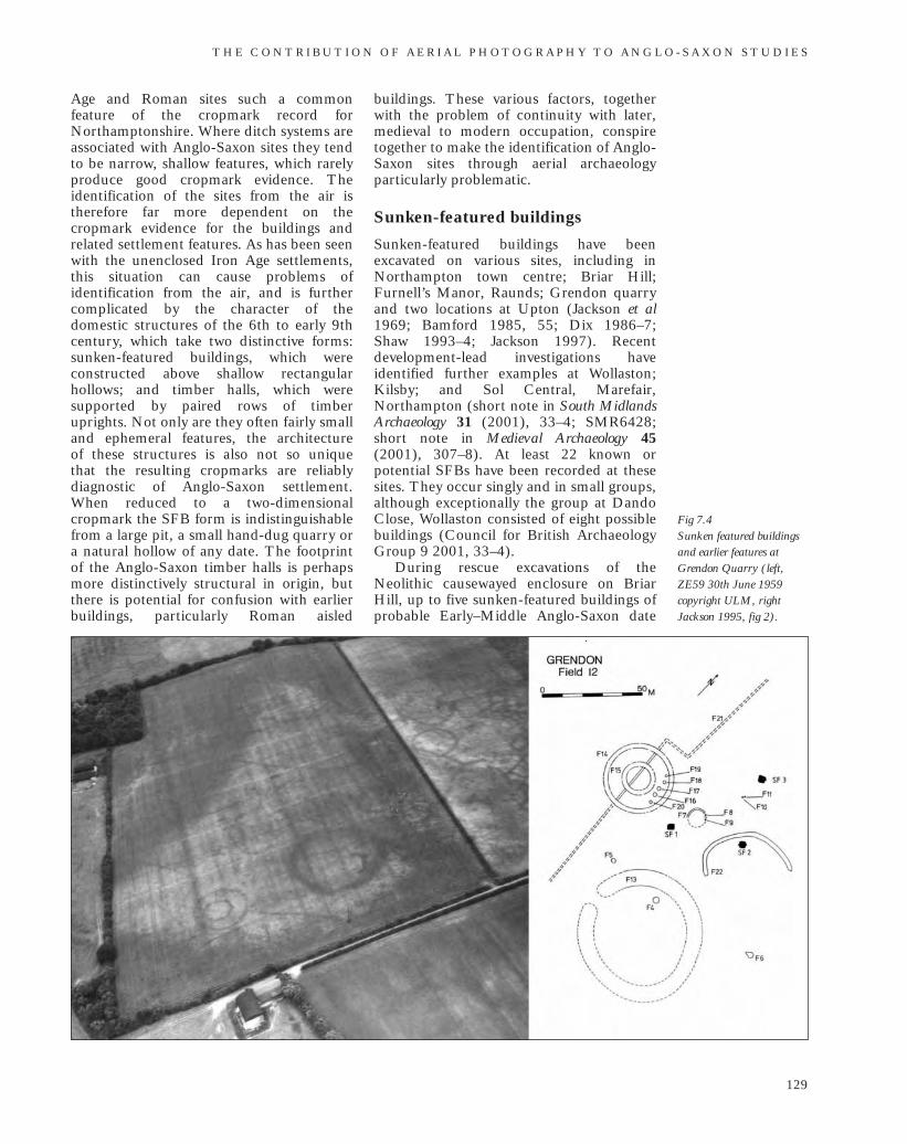
Age and Roman sites such a commonfeature of the cropmark record forNorthamptonshire. Where ditch systems areassociated with Anglo-Saxon sites they tendto be narrow, shallow features, which rarelyproduce good cropmark evidence. Theidentification of the sites from the air istherefore far more dependent on thecropmark evidence for the buildings andrelated settlement features. As has been seenwith the unenclosed Iron Age settlements,this situation can cause problems ofidentification from the air, and is furthercomplicated by the character of thedomestic structures of the 6th to early 9thcentury, which take two distinctive forms:sunken-featured buildings, which wereconstructed above shallow rectangularhollows; and timber halls, which weresupported by paired rows of timberuprights. Not only are they often fairly smalland ephemeral features, the architecture of these structures is also not so unique that the resulting cropmarks are reliablydiagnostic of Anglo-Saxon settlement.When reduced to a two-dimensionalcropmark the SFB form is indistinguishablefrom a large pit, a small hand-dug quarry ora natural hollow of any date. The footprintof the Anglo-Saxon timber halls is perhapsmore distinctively structural in origin, butthere is potential for confusion with earlierbuildings, particularly Roman aisled
buildings. These various factors, togetherwith the problem of continuity with later,medieval to modern occupation, conspiretogether to make the identification of Anglo-Saxon sites through aerial archaeologyparticularly problematic.
Sunken-featured buildings
Sunken-featured buildings have beenexcavated on various sites, including inNorthampton town centre; Briar Hill;Furnell’s Manor, Raunds; Grendon quarryand two locations at Upton (Jackson et al1969; Bamford 1985, 55; Dix 1986–7;Shaw 1993–4; Jackson 1997). Recentdevelopment-lead investigations haveidentified further examples at Wollaston;Kilsby; and Sol Central, Marefair,Northampton (short note in South MidlandsArchaeology 31 (2001), 33–4; SMR6428;short note in Medieval Archaeology 45(2001), 307–8). At least 22 known orpotential SFBs have been recorded at thesesites. They occur singly and in small groups,although exceptionally the group at DandoClose, Wollaston consisted of eight possiblebuildings (Council for British ArchaeologyGroup 9 2001, 33–4).
During rescue excavations of theNeolithic causewayed enclosure on BriarHill, up to five sunken-featured buildings ofprobable Early–Middle Anglo-Saxon date
T H E C O N T R I B U T I O N O F A E R I A L P H O T O G R A P H Y T O A N G L O - S A X O N S T U D I E S
129
Fig 7.4 Sunken featured buildingsand earlier features atGrendon Quarry (left,ZE59 30th June 1959copyright ULM, rightJackson 1995, fig 2).
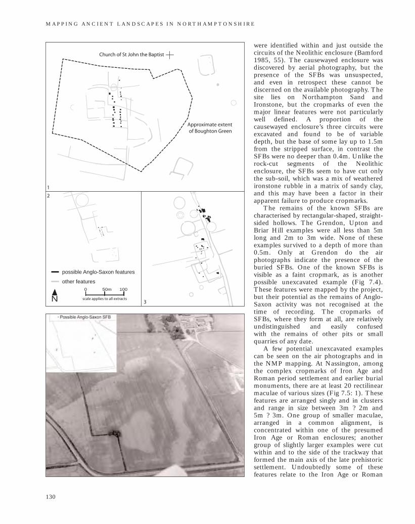
were identified within and just outside thecircuits of the Neolithic enclosure (Bamford1985, 55). The causewayed enclosure wasdiscovered by aerial photography, but thepresence of the SFBs was unsuspected, and even in retrospect these cannot bediscerned on the available photography. Thesite lies on Northampton Sand andIronstone, but the cropmarks of even themajor linear features were not particularlywell defined. A proportion of thecausewayed enclosure’s three circuits wereexcavated and found to be of variable depth, but the base of some lay up to 1.5mfrom the stripped surface, in contrast theSFBs were no deeper than 0.4m. Unlike therock-cut segments of the Neolithicenclosure, the SFBs seem to have cut onlythe sub-soil, which was a mix of weatheredironstone rubble in a matrix of sandy clay,and this may have been a factor in theirapparent failure to produce cropmarks.
The remains of the known SFBs arecharacterised by rectangular-shaped, straight-sided hollows. The Grendon, Upton andBriar Hill examples were all less than 5mlong and 2m to 3m wide. None of theseexamples survived to a depth of more than0.5m. Only at Grendon do the airphotographs indicate the presence of theburied SFBs. One of the known SFBs isvisible as a faint cropmark, as is anotherpossible unexcavated example (Fig 7.4).These features were mapped by the project,but their potential as the remains of Anglo-Saxon activity was not recognised at thetime of recording. The cropmarks of SFBs, where they form at all, are relativelyundistinguished and easily confused with the remains of other pits or smallquarries of any date.
A few potential unexcavated examplescan be seen on the air photographs and inthe NMP mapping. At Nassington, amongthe complex cropmarks of Iron Age andRoman period settlement and earlier burialmonuments, there are at least 20 rectilinearmaculae of various sizes (Fig 7.5: 1). Thesefeatures are arranged singly and in clustersand range in size between 3m ? 2m and 5m ? 3m. One group of smaller maculae,arranged in a common alignment, isconcentrated within one of the presumedIron Age or Roman enclosures; anothergroup of slightly larger examples were cutwithin and to the side of the trackway thatformed the main axis of the late prehistoricsettlement. Undoubtedly some of thesefeatures relate to the Iron Age or Roman
M A P P I N G A N C I E N T L A N D S C A P E S I N N O RT H A M P T O N S H I R E
130
N50m0 100
scale applies to all extracts
other features
possible Anglo-Saxon features
1
2
3
Approximate extent of Boughton Green
Church of St John the Baptist
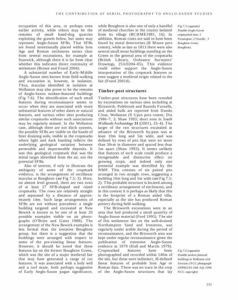
Fig 7.5 (opposite)Possible Anglo-Saxoncropmarked sites: 1Nassington; 2 Oundle; 3Boughton Green,Boughton).
occupation of this area, or perhaps evenearlier activity, while others may be theremains of small hand-dug quarriesexploiting the gravels below, but some mayrepresent Anglo-Saxon SFBs. That SFBsare found intentionally placed within IronAge and Roman enclosures seems clearfrom several excavations, for example atStanwick, although there it is far from clearwhether this indicates direct continuity ofsettlement (Brown and Foard 2004).
A substantial number of Early–MiddleAnglo-Saxon sites known from field-walkingand excavation is, however, in isolation.Thus, maculae identified in isolation atWollaston may also prove to be the remainsof Anglo-Saxon sunken-featured buildings(Fig 7.6). The identification of such smallfeatures during reconnaissance seems tooccur when they are associated with moresubstantial features of other dates or naturalfeatures, and various other sites producingsimilar cropmarks without such associationsmay be regularly missed. In the Wollastoncase, although there are not ditch systems,the possible SFBs are visible on the bands offreer draining soils, visible in the cropmarkswhere light and dark banding reflects theunderlying geological variation betweenpermeable and impermeable deposits. Itwas this geological cropmark that was theinitial target identified from the air, not thepotential SFBs.
Also of interest, if only to illustrate theambiguity of some of the cropmarkevidence, is the arrangement of rectilinearmaculae at Boughton (see Fig 7.5: 3). Here,on almost level ground, there are two rowsof at least 27 SFB-shaped and -sizedcropmarks. The rows are relatively straightand separated by a distance of approx-imately 14m. Such large arrangements ofSFBs are not without precedent: a singlebuilding targeted and excavated at NewBewick is known to be one of at least 20possible examples visible on air photo-graphs (O’Brien and Gates 1988). Thearrangement of the New Bewick examples isless formal than the tentative Boughtongroup, but there is a suggestion that thebuildings were arranged with respect tosome of the pre-existing linear features.However, it should be noted that thesefeatures lay on the former Boughton Green,which was the site of a major medieval fairthat may have generated a range of cutfeatures. It was associated with a holy welland a turf maze, both perhaps suggestive of Early Anglo-Saxon pagan significance,
while Boughton is also one of only a handfulof medieval churches in the county isolatedfrom its village (RCHME1981, 16). Inaddition, Roman coins are said to have beenfound by metal detectorists (R Moore perscomm), while as late as 1813 there were alsoseveral small stone buildings standing on theGreen in the general area of the cropmarks(British Library, Ordnance Surveyors’Drawings, 253c0204–05). This evidencecould either support the Anglo-Saxoninterpretation of the cropmark features oreven suggest a medieval origin related to thefair (Foard 2001d).
Timber-post structures
Timber-post structures have been revealedby excavations on various sites including atBrixworth, Polebrook and Raunds Furnells,and aisled halls are reported from DandoClose, Wollaston (S Upex pers comm; Dix1986–7, 3; Shaw 1993; short note in SouthMidlands Archaeology 31 (2001), 33–4). Thelarger of the two structures excavated inadvance of the Brixworth by-pass was atleast 10m long and 5m wide, and wasdefined by rows of pits that were no morethan 30cm in diameter and spaced less than1m apart (Shaw 1993). It seems unlikelythat features of such scale could produce arecognisable and distinctive effect ongrowing crops, and indeed only onepotential example was identified by theNMP. This consists of six paired pitsarranged in two straight rows, suggesting abuilding 16m long and 5m wide (see Fig 7.5:2). This probable structure is located amonga rectilinear arrangement of enclosures, andin this context it is perhaps as likely that thisis the footprint of a Roman aisled villa,especially as the site has produced Romanpottery during field-walking.
The Brixworth excavations were in anarea that had produced a small quantity ofAnglo-Saxon material (Ford 1995). The siteof this settlement lies on the well-drainedNorthampton Sand and Ironstone, wasregularly under arable during the period ofreconnaissance, and the Brixworth area waskept under regular reconnaissance given thepublication of extensive Anglo-Saxonevidence in 1979 (Hall and Martin 1979).Cropmarked features have beenphotographed and recorded within 140m ofthe site, but these were indistinct, ill-definedlinear features of probable Iron Age orRoman date. There was no trace in the cropof the Anglo-Saxon structures that lay
T H E C O N T R I B U T I O N O F A E R I A L P H O T O G R A P H Y T O A N G L O - S A X O N S T U D I E S
131
Fig 7.6 (opposite)Possible sunken featuredbuildings at Wollaston andStrixton (NCC photographSP8962/43 19th July 1996NCC copyright)
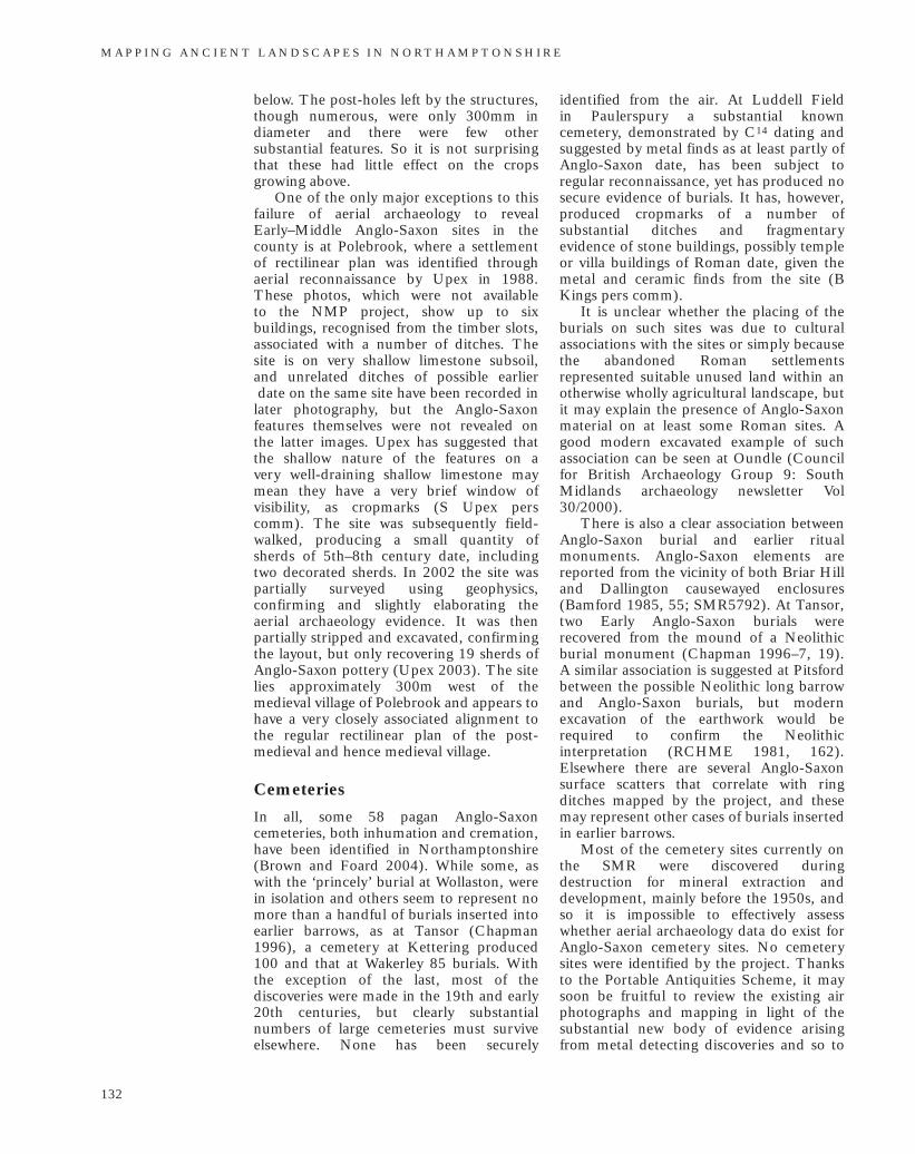
below. The post-holes left by the structures,though numerous, were only 300mm indiameter and there were few othersubstantial features. So it is not surprisingthat these had little effect on the cropsgrowing above.
One of the only major exceptions to thisfailure of aerial archaeology to revealEarly–Middle Anglo-Saxon sites in thecounty is at Polebrook, where a settlementof rectilinear plan was identified throughaerial reconnaissance by Upex in 1988.These photos, which were not available to the NMP project, show up to sixbuildings, recognised from the timber slots,associated with a number of ditches. Thesite is on very shallow limestone subsoil, and unrelated ditches of possible earlierdate on the same site have been recorded in
later photography, but the Anglo-Saxonfeatures themselves were not revealed on the latter images. Upex has suggested thatthe shallow nature of the features on a very well-draining shallow limestone maymean they have a very brief window ofvisibility, as cropmarks (S Upex perscomm). The site was subsequently field-walked, producing a small quantity ofsherds of 5th–8th century date, includingtwo decorated sherds. In 2002 the site waspartially surveyed using geophysics,confirming and slightly elaborating theaerial archaeology evidence. It was thenpartially stripped and excavated, confirmingthe layout, but only recovering 19 sherds ofAnglo-Saxon pottery (Upex 2003). The sitelies approximately 300m west of themedieval village of Polebrook and appears tohave a very closely associated alignment tothe regular rectilinear plan of the post-medieval and hence medieval village.
Cemeteries
In all, some 58 pagan Anglo-Saxoncemeteries, both inhumation and cremation,have been identified in Northamptonshire(Brown and Foard 2004). While some, aswith the ‘princely’ burial at Wollaston, werein isolation and others seem to represent nomore than a handful of burials inserted intoearlier barrows, as at Tansor (Chapman1996), a cemetery at Kettering produced100 and that at Wakerley 85 burials. Withthe exception of the last, most of thediscoveries were made in the 19th and early20th centuries, but clearly substantialnumbers of large cemeteries must surviveelsewhere. None has been securely
identified from the air. At Luddell Field in Paulerspury a substantial knowncemetery, demonstrated by C14 dating andsuggested by metal finds as at least partly ofAnglo-Saxon date, has been subject toregular reconnaissance, yet has produced nosecure evidence of burials. It has, however,produced cropmarks of a number ofsubstantial ditches and fragmentaryevidence of stone buildings, possibly templeor villa buildings of Roman date, given themetal and ceramic finds from the site (BKings pers comm).
It is unclear whether the placing of theburials on such sites was due to culturalassociations with the sites or simply becausethe abandoned Roman settlementsrepresented suitable unused land within anotherwise wholly agricultural landscape, butit may explain the presence of Anglo-Saxonmaterial on at least some Roman sites. Agood modern excavated example of suchassociation can be seen at Oundle (Councilfor British Archaeology Group 9: SouthMidlands archaeology newsletter Vol30/2000).
There is also a clear association betweenAnglo-Saxon burial and earlier ritualmonuments. Anglo-Saxon elements arereported from the vicinity of both Briar Hilland Dallington causewayed enclosures(Bamford 1985, 55; SMR5792). At Tansor,two Early Anglo-Saxon burials wererecovered from the mound of a Neolithicburial monument (Chapman 1996–7, 19).A similar association is suggested at Pitsfordbetween the possible Neolithic long barrowand Anglo-Saxon burials, but modernexcavation of the earthwork would berequired to confirm the Neolithicinterpretation (RCHME 1981, 162).Elsewhere there are several Anglo-Saxonsurface scatters that correlate with ringditches mapped by the project, and thesemay represent other cases of burials insertedin earlier barrows.
Most of the cemetery sites currently onthe SMR were discovered duringdestruction for mineral extraction anddevelopment, mainly before the 1950s, andso it is impossible to effectively assesswhether aerial archaeology data do exist forAnglo-Saxon cemetery sites. No cemeterysites were identified by the project. Thanksto the Portable Antiquities Scheme, it maysoon be fruitful to review the existing airphotographs and mapping in light of thesubstantial new body of evidence arisingfrom metal detecting discoveries and so to
M A P P I N G A N C I E N T L A N D S C A P E S I N N O RT H A M P T O N S H I R E
132
investigate the associations between findsand cropmarks, and perhaps even to focusnew reconnaissance on likely cemetery sites.
In light of this situation, it may soon be possible to review the existing aerialphotography and mapping to seek assoc-iations with cropmark sites, or even toconduct new, targeted reconnaissance ofprobable cemetery sites.
Continuity or discontinuitybetween Roman and medievallandscapesA major research theme in landscape studiesconcerns the degree to which there wascontinuity between the Early–MiddleAnglo-Saxon and the preceding Romanlandscape, and when and within whatframework the medieval open field systemwas laid out. While it now seems clear thatin Northamptonshire the medieval openfield system originated in large part in amajor Late Anglo-Saxon replanning of the landscape, it is still uncertain how early some elements of the system began tobe created, or indeed what skeleton itinherited from the earlier landscape (Brownand Foard 1998).
The Anglo-Saxon landscape has alwaysbeen invisible. It is unclear whether this was because Roman systems continued inuse and hence there was no need for large-scale new land division, or because theland management did not involve thedigging of major deep ditched boundaries,as was certainly true in the settlementsthemselves. But there are ways in which theproblem can be addressed, and aerialarchaeology has a major contribution tomake in the investigation of this criticaltransition from the ‘Celtic’ to the ‘English’landscape. This is because it can providedetailed and extensive, if often fragmentary,evidence for the layout of that Celticlandscape. However, the value of this datacan only be fully realised once the large-scale patterning of the medieval open fieldlandscape is also available in GIS, to overlayupon the ‘Celtic’ dataset provided throughthe NMP. Only then will it be possible torecognise the fine detail of continuity ordiscontinuity between the two.
This key issue cannot therefore beaddressed here and must await the results ofthe ongoing AHRC funded project(2005–9) to map and analyse the historiclandscape of Northamptonshire (Foard et al2005). All that can be considered here are
associations with the basic mapping oftownship boundaries prepared in GIS frompost-medieval mapping by Hall and Foard(Foard 2001c).
Some authors have suggested thatmedieval townships in general have veryancient origins (Taylor 1983, 104–5 and124). In specific cases there is equivocalevidence that some of the medievaltownships do indeed owe their origins, inpart at least, to the administrative ortenurial arrangement of the Romanlandscape (Foard 2001b, 5–6). It has beenargued that the presence of Roman villas atthe centre of townships is evidence thattownship origins lay in the estates of formervillas. An assessment of the location of allthe known villas suggests that in fact at leasthalf lie on or close to township boundaries.Many township boundaries follow naturalwater courses and many villas were sitedclose to water sources, so it could be arguedthat any such association is coincidental.However, ‘dry’ township boundaries alsopass through or close by known and possiblevillas, as at Overstone (SMR 2064),Wakerley (SMR site 5644), Yarwell (2729),Mileoak (734), Weekley (3910),Wellingborough (3636), Kettering (3957),Geddington (2571) and Gretton (3064). Ineffect, the areas that had been occupied bythese villas seem to have become ratherperipheral by the medieval period. Thisassociation is not restricted to the villa sites,for many township boundaries cut acrossthe location of other Iron Age opensettlements, and across Iron Age andRoman enclosed rural settlements.
In reality, however, if the argument hasany validity, the associations are likely to befar more complex, as for example has beensuggested for the massive Cotterstock villa.This lies in the centre of a large area ofintercommoned land between the townshipsof Cotterstock and Glapthorn (Foard1988). At present it does, however, seemthat there is actually a high level ofdiscontinuity between the two landscapes.But the detailed investigation of this themelies outside the scope of the present study.
By far the clearest association betweenthe township pattern and the underlyingCeltic landscape is seen at Charlton, wherethere is a probable Iron Age boundarysystem representing a massive ovalenclosure, with an apparent drove leadingnorth out of it, ditched boundaries radiatingout from it and with at least one Iron Age or Roman settlement set on its periphery
T H E C O N T R I B U T I O N O F A E R I A L P H O T O G R A P H Y T O A N G L O - S A X O N S T U D I E S
133
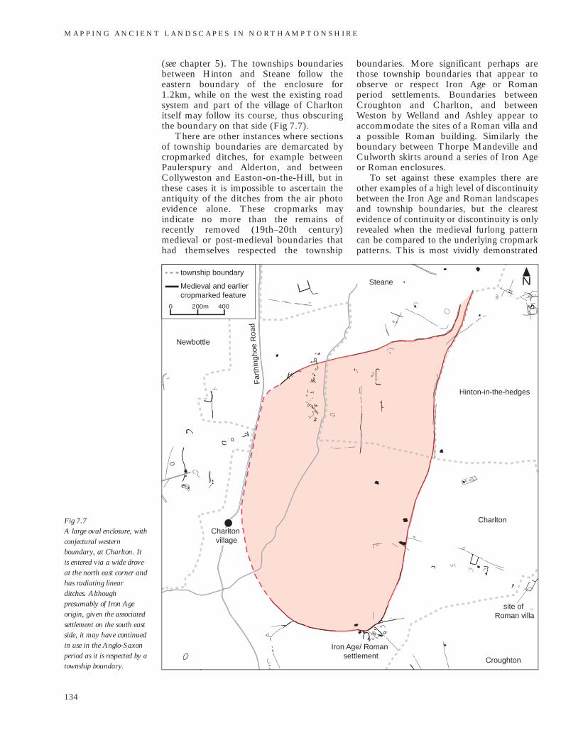
M A P P I N G A N C I E N T L A N D S C A P E S I N N O RT H A M P T O N S H I R E
134
Fig 7.7 A large oval enclosure, withconjectural westernboundary, at Charlton. Itis entered via a wide droveat the north east corner andhas radiating linearditches. Althoughpresumably of Iron Ageorigin, given the associatedsettlement on the south eastside, it may have continuedin use in the Anglo-Saxonperiod as it is respected by atownship boundary.
Newbottle
Charlton
Hinton-in-the-hedges
Steane
Croughton
Far
thin
ghoe
Roa
d
Charlton village
Iron Age/ Roman settlement
site of Roman villa
N
200m0 400
township boundary
Medieval and earlier cropmarked feature
(see chapter 5). The townships boundariesbetween Hinton and Steane follow theeastern boundary of the enclosure for1.2km, while on the west the existing roadsystem and part of the village of Charltonitself may follow its course, thus obscuringthe boundary on that side (Fig 7.7).
There are other instances where sectionsof township boundaries are demarcated bycropmarked ditches, for example betweenPaulerspury and Alderton, and betweenCollyweston and Easton-on-the-Hill, but inthese cases it is impossible to ascertain theantiquity of the ditches from the air photoevidence alone. These cropmarks mayindicate no more than the remains ofrecently removed (19th–20th century)medieval or post-medieval boundaries thathad themselves respected the township
boundaries. More significant perhaps arethose township boundaries that appear toobserve or respect Iron Age or Romanperiod settlements. Boundaries betweenCroughton and Charlton, and betweenWeston by Welland and Ashley appear toaccommodate the sites of a Roman villa anda possible Roman building. Similarly theboundary between Thorpe Mandeville andCulworth skirts around a series of Iron Ageor Roman enclosures.
To set against these examples there areother examples of a high level of discontinuitybetween the Iron Age and Roman landscapesand township boundaries, but the clearestevidence of continuity or discontinuity is onlyrevealed when the medieval furlong patterncan be compared to the underlying cropmarkpatterns. This is most vividly demonstrated

at Faxton where complete discontinuitybetween the two systems is demonstrated (Fig7.8). When such comparison is undertakenon a countywide scale using the NMP data, it is likely that some tracts of land will show high levels of discontinuity while others will show continuity, thus perhapsrevealing a great deal about the nature of theAnglo-Saxon landscape.
Discussion and conclusionAerial survey has produced only limitedevidence for the physical remains of Anglo-Saxon settlement and burial sites. It is likelythat intensive and targeted research,particularly through well-recordedsystematic field-walking of cropmark sitesand by reassessment of cropmark evidence
on Anglo-Saxon cemetery and other sitesindicated by metal detecting finds, wouldimprove this situation. However, given theoften ephemeral nature of Anglo-Saxonevidence where it has been revealed throughexcavation, one cannot expect anythingcomparable to the results aerial archaeologyhas yielded for the Iron Age and Romanlandscape of Northamptonshire. Ironically,however, it is perhaps through the latter thataerial data may deliver by far the greatestcontribution to the study of the Anglo-Saxon landscape, by making it possible tocompare on a large scale the Iron Age /Roman landscape and the open field furlongpattern that was laid out in the Late Saxonperiod, enabling a detailed exploration ofissues of continuity and discontinuitybetween AD 400 and 1000.
T H E C O N T R I B U T I O N O F A E R I A L P H O T O G R A P H Y T O A N G L O - S A X O N S T U D I E S
135
Fig 7.8 Discontinuity between theIron Age/Roman boundarysystem and the pattern ofmedieval furlongs atFaxton. (NCC photographSP7874/018 1st August1986 NCC copyright)