Embed Size (px)
Citation preview
9 0 M U E L L E R D E S I G N B O O K • N O V E M B E R 2 0 0 4 C H A P T E R F I V E : O P E N S P A C E A N D R E C R E A T I O N 9 1
5O P E N S PAC E A N D R E C R E AT I O N
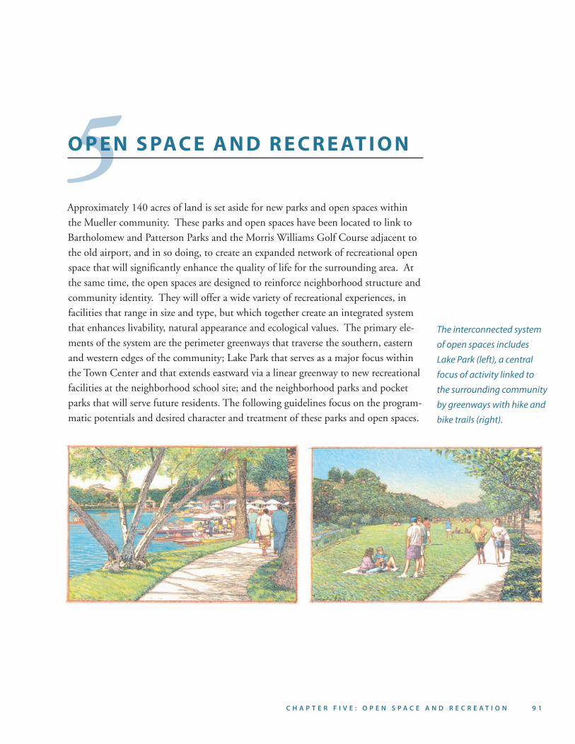
Approximately 140 acres of land is set aside for new parks and open spaces within the Mueller community. These parks and open spaces have been located to link to Bartholomew and Patterson Parks and the Morris Williams Golf Course adjacent to the old airport, and in so doing, to create an expanded network of recreational open space that will significantly enhance the quality of life for the surrounding area. At the same time, the open spaces are designed to reinforce neighborhood structure and community identity. They will offer a wide variety of recreational experiences, in facilities that range in size and type, but which together create an integrated system that enhances livability, natural appearance and ecological values. The primary ele-ments of the system are the perimeter greenways that traverse the southern, eastern and western edges of the community; Lake Park that serves as a major focus within the Town Center and that extends eastward via a linear greenway to new recreational facilities at the neighborhood school site; and the neighborhood parks and pocket parks that will serve future residents. The following guidelines focus on the program-matic potentials and desired character and treatment of these parks and open spaces.
The interconnected system
of open spaces includes
Lake Park (left), a central
focus of activity linked to
the surrounding community
by greenways with hike and
bike trails (right).
9 2 M U E L L E R D E S I G N B O O K • N O V E M B E R 2 0 0 4 C H A P T E R F I V E : O P E N S P A C E A N D R E C R E A T I O N 9 3
9 2 M U E L L E R D E S I G N B O O K • N O V E M B E R 2 0 0 4 C H A P T E R F I V E : O P E N S P A C E A N D R E C R E A T I O N 9 3
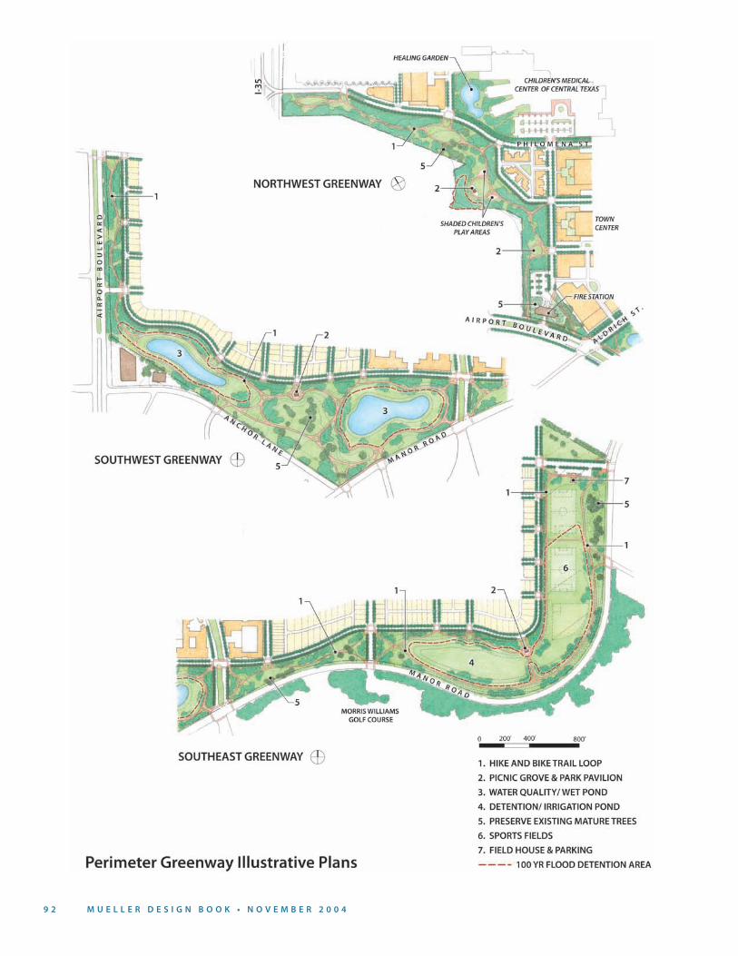
5.1 P E R I M E T E R G R E E N WAYS
The perimeter greenways total approximately 75 acres of land and have been devel-oped as broad greenswards that provide a strong visual edge and linear progression of recreational activities. They are predominantly green open spaces composed of a series of clearings or “outdoor rooms” defined by large trees. The perimeter greenways also play an important environmental and ecological role, detaining and filtering stormwater before it re-enters the natural creek systems of the area. The greenways include three major assemblages, each with its own role and character. The greenway to the northwest adjoins the Children’s Hospital campus as well as the existing Delwood II neighborhood. Within this perimeter greenway are a number of mature trees to be preserved and an existing stormwater detention area. In addition to serving larger greenway purposes related to linear recreation and storm drainage, this greenway is also envisioned as an amenity for the hospital and adjacent residents. It provides for children’s play areas and family picnic grounds, provides a landscape screen to the fire station parking lot and links directly across Aldrich Street to Lake Park. The greenway to the southwest also connects to Lake Park and is notable for its stands of existing trees which will remain. Wet ponds are located within this widened greenway which is the terminus of a number of streets from the new neigh-borhood to the north. The southeastern greenway, adjacent to Morris Williams Golf Course, features a detention irrigation pond and playfields in the detention meadows.
Linkages. A relatively unbroken continuity of open space will be created within the perimeter greenway with strong linkages to existing parks (i.e., Patterson Park, Morris Williams Golf Course and Bartholomew Park) as well as planned neighborhood parks. The pattern of roadways within the Mueller community will be designed to enhance accessibility to the perimeter greenway and to make it more visible to surrounding areas.
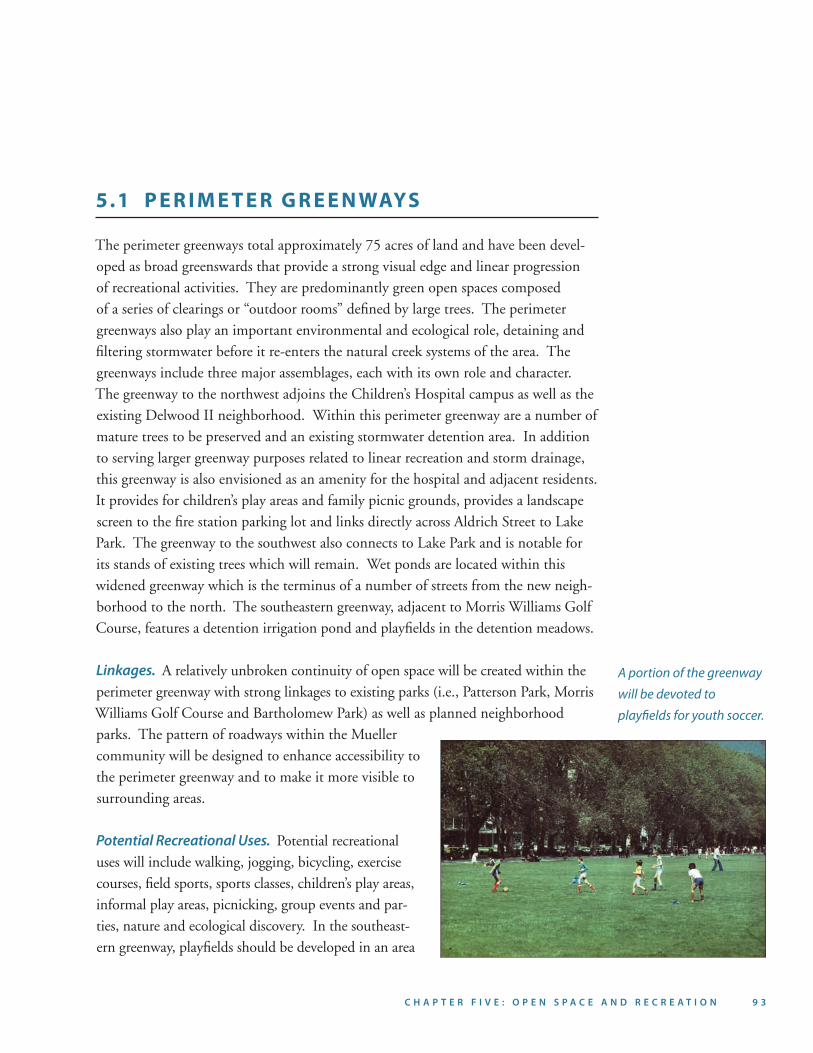
Potential Recreational Uses. Potential recreational uses will include walking, jogging, bicycling, exercise courses, field sports, sports classes, children’s play areas, informal play areas, picnicking, group events and par-ties, nature and ecological discovery. In the southeast-ern greenway, playfields should be developed in an area
A portion of the greenway
will be devoted to
playfields for youth soccer.
9 4 M U E L L E R D E S I G N B O O K • N O V E M B E R 2 0 0 4 C H A P T E R F I V E : O P E N S P A C E A N D R E C R E A T I O N 9 5
of approximately 20 acres for multi-use playfields (pri-marily soccer) as well as playgrounds and group picnic facilities. The playfields are intended for youth league practice fields. Small, well-landscaped and screened parking lots of less than 50 cars each should be provided to serve the users of the fields. The recommended park-ing ratio for playfields is 25 spaces per field. The fields will not be lighted.
Trail System: A continuous hike/bike trail of a width of no less than 10 feet will be developed with an acces-sible gradient along its length. The hike/bike trail will
become the backbone for recreational experiences within the perimeter greenway, tying together the entire greenway system and recreational experiences within it. The hike/bike trail should connect to secondary paths (of a minimum six-foot width) and where possible, a looping route should be incorporated into each of the three greenway segments, creating smaller systems that can be used independently from the larger overall system. Consideration should be given to the provision of safe con-nections for cyclists and pedestrians between adjacent parks and neighborhoods and the greenway system. Trail access points should be clearly marked, providing infor-mation, seating, “parcourse” exercise equipment, shade and drinking water. These trailheads should also be large enough for groups to gather.
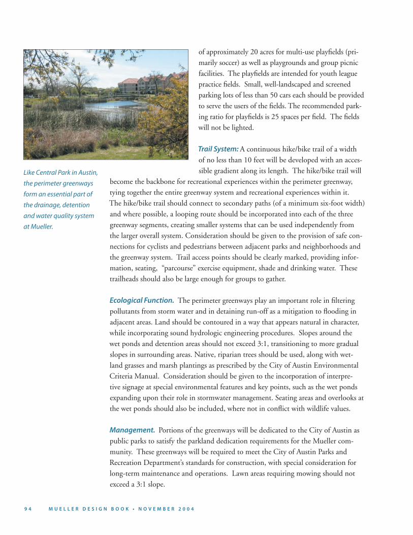
Ecological Function. The perimeter greenways play an important role in filtering pollutants from storm water and in detaining run-off as a mitigation to flooding in adjacent areas. Land should be contoured in a way that appears natural in character, while incorporating sound hydrologic engineering procedures. Slopes around the wet ponds and detention areas should not exceed 3:1, transitioning to more gradual slopes in surrounding areas. Native, riparian trees should be used, along with wet-land grasses and marsh plantings as prescribed by the City of Austin Environmental Criteria Manual. Consideration should be given to the incorporation of interpre-tive signage at special environmental features and key points, such as the wet ponds expanding upon their role in stormwater management. Seating areas and overlooks at the wet ponds should also be included, where not in conflict with wildlife values.
Management. Portions of the greenways will be dedicated to the City of Austin as public parks to satisfy the parkland dedication requirements for the Mueller com-munity. These greenways will be required to meet the City of Austin Parks and Recreation Department’s standards for construction, with special consideration for long-term maintenance and operations. Lawn areas requiring mowing should not exceed a 3:1 slope.
Like Central Park in Austin,
the perimeter greenways
form an essential part of
the drainage, detention
and water quality system
at Mueller.
9 4 M U E L L E R D E S I G N B O O K • N O V E M B E R 2 0 0 4 C H A P T E R F I V E : O P E N S P A C E A N D R E C R E A T I O N 9 5
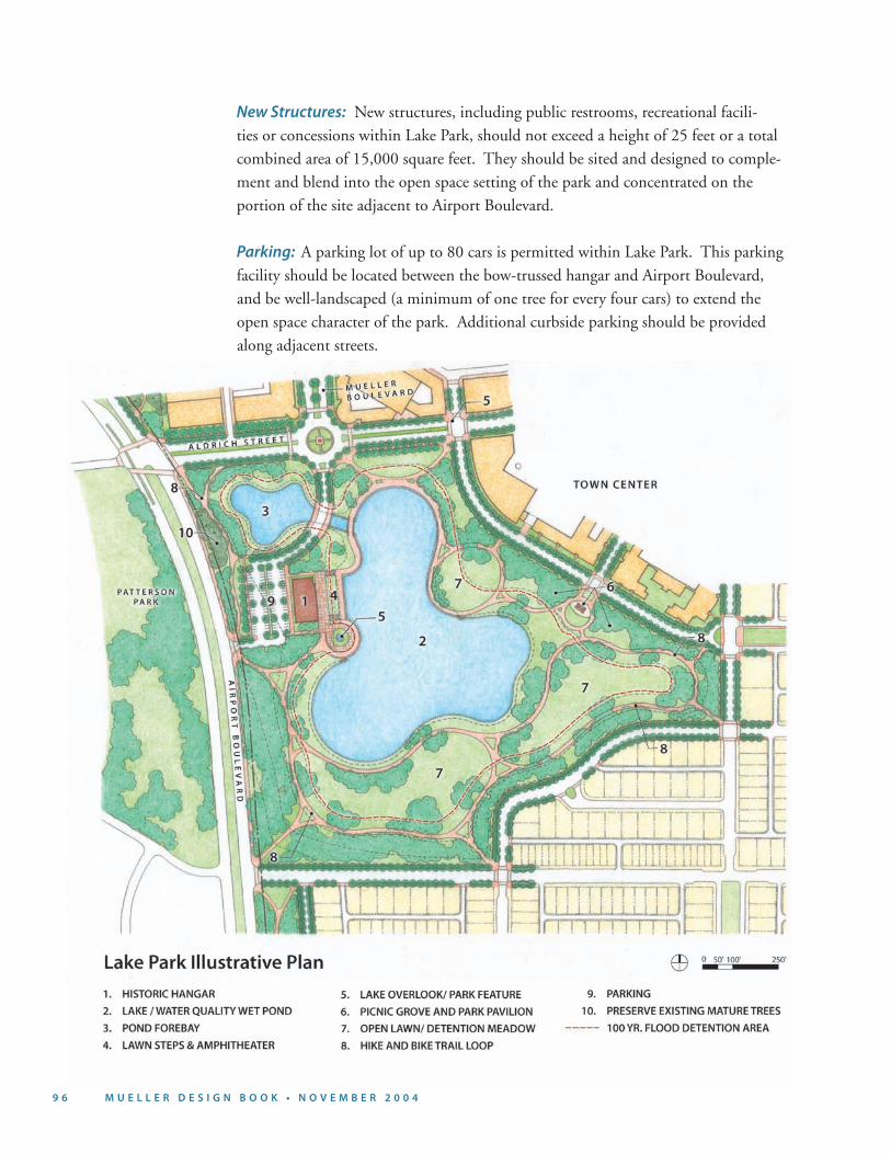
5.2 L A K E PA R K
Lake Park, approximately 30 acres in size, is designed as an integral extension of the greenway system and as a central focus and amenity for the entire community. It is envisioned as a major destination for recreational users jogging, hiking and bicycling through the greenway. Located along Airport Boulevard, Lake Park will provide an important “front door” to the Mueller community, establishing a new identity for the site and an attractive visual setting for the Town Center. Lake Park offers views from the center of the new community to the downtown Austin skyline, the Capitol dome and the UT tower.
Landscape Character: Lake Park should have a predominantly naturalistic character, with open meadows defined by canopy trees surrounding the lake. The edges around the lake should provide opportunities for people to promenade along and overlook the water. A promenade edge with a low bulkhead wall should be provided along the more urbanized edge of the lake adjacent to the Town Center.
Potential Recreational Uses: Lake Park will be designed for a variety of uses, such as community celebrations, concerts, outdoor theater and performances, special events, weddings, parties, outdoor dining, art fairs, festivals, farmers’ markets, jog-ging, walking, boat/bicycle rental concessions, paddleboats, model boat sailing and canoeing. A natural amphitheater should be designed with a sloping grade into and along the banks of the lake; performances could be staged at the edge of the lake and/or from a floating stage within the water body. A boathouse (potentially located within the bow-trussed hangar) should be incorporated within the park to provide a boat and bicycle rental concession.
Bow-Trussed Hangar: The bow-trussed hangar structure should be studied to deter-mine the feasibility of retaining it as a landmark within the park for community use, a publicly oriented commercial-recreational use and/or as a sales and information centr for Mueller.
Hike/Bike Trail: The hike/bike trail will extend through Lake Park, linking the northwest and southwest portions of the perimeter greenway as well as providing a looping route within the park itself. The trail should be lit with full-cut off and fully-shielded path lights.
9 6 M U E L L E R D E S I G N B O O K • N O V E M B E R 2 0 0 4 C H A P T E R F I V E : O P E N S P A C E A N D R E C R E A T I O N 9 7
New Structures: New structures, including public restrooms, recreational facili-ties or concessions within Lake Park, should not exceed a height of 25 feet or a total combined area of 15,000 square feet. They should be sited and designed to comple-ment and blend into the open space setting of the park and concentrated on the portion of the site adjacent to Airport Boulevard.
Parking: A parking lot of up to 80 cars is permitted within Lake Park. This parking facility should be located between the bow-trussed hangar and Airport Boulevard, and be well-landscaped (a minimum of one tree for every four cars) to extend the open space character of the park. Additional curbside parking should be provided along adjacent streets.
9 6 M U E L L E R D E S I G N B O O K • N O V E M B E R 2 0 0 4 C H A P T E R F I V E : O P E N S P A C E A N D R E C R E A T I O N 9 7
5.3 S C H O O L A N D R E C R E AT I O N A L A R E A
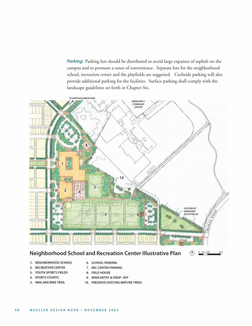
At the eastern end of the Mueller community, a new neighborhood school and joint use recreational center is to be built on a site of approximately 20 acres to accommo-date recreational fields that are open and accessible to the public.
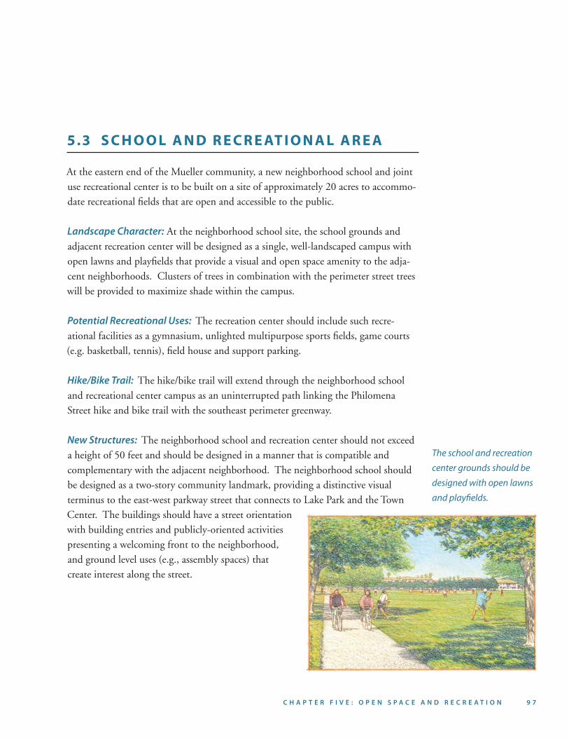
Landscape Character: At the neighborhood school site, the school grounds and adjacent recreation center will be designed as a single, well-landscaped campus with open lawns and playfields that provide a visual and open space amenity to the adja-cent neighborhoods. Clusters of trees in combination with the perimeter street trees will be provided to maximize shade within the campus.
Potential Recreational Uses: The recreation center should include such recre-ational facilities as a gymnasium, unlighted multipurpose sports fields, game courts (e.g. basketball, tennis), field house and support parking.
Hike/Bike Trail: The hike/bike trail will extend through the neighborhood school and recreational center campus as an uninterrupted path linking the Philomena Street hike and bike trail with the southeast perimeter greenway.
New Structures: The neighborhood school and recreation center should not exceed a height of 50 feet and should be designed in a manner that is compatible and complementary with the adjacent neighborhood. The neighborhood school should be designed as a two-story community landmark, providing a distinctive visual terminus to the east-west parkway street that connects to Lake Park and the Town Center. The buildings should have a street orientation with building entries and publicly-oriented activities presenting a welcoming front to the neighborhood, and ground level uses (e.g., assembly spaces) that create interest along the street.
The school and recreation
center grounds should be
designed with open lawns
and playfields.
9 8 M U E L L E R D E S I G N B O O K • N O V E M B E R 2 0 0 4 C H A P T E R F I V E : O P E N S P A C E A N D R E C R E A T I O N 9 9
Parking: Parking lots should be distributed to avoid large expanses of asphalt on the campus and to promote a sense of convenience. Separate lots for the neighborhood school, recreation center and the playfields are suggested. Curbside parking will also provide additional parking for the facilities. Surface parking shall comply with the landscape guidelines set forth in Chapter Six.
9 8 M U E L L E R D E S I G N B O O K • N O V E M B E R 2 0 0 4 C H A P T E R F I V E : O P E N S P A C E A N D R E C R E A T I O N 9 9
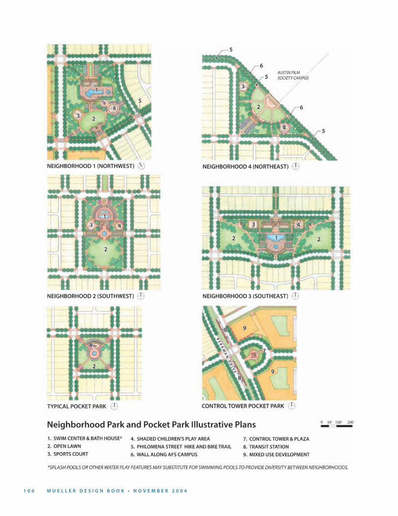
5.4 NEIGHBORHOOD PARKS AND POCKET PARKS
Neighborhood parks of approximately two to three acres in size are planned as the principal focus and gathering space for each of Mueller’s four neighborhoods. These parks will typically include a variety of active and passive recreational facilities, and will require careful site planning to maintain a predominantly green, verdant character with no more than fifty percent impervious cover.
A series of smaller pocket parks of approximately one-quarter to one acre in size are also planned within each neighborhood. These pocket parks are located so as to ensure that all residents are within 600 feet of a park and configured to create a focus for neighbor-hood subareas. These parks, like the neighborhood parks, should be designed to serve the special recreational interests of the community and reflect the demographic char-acteristics of each neighborhood. It is important that these small parks be designed as simple and flexible open spaces suitable for a wide range of informal use.
Potential Recreational Uses: Neighborhood parks will be designed to provide for a variety of activities, such as: swimming, multi-use play lawns, picnicking, children’s play, neighborhood gatherings, etc. Pocket parks will be designed to provide for a variety of activities, such as children’s play areas, formal and informal seating areas, neighborhood festivals and gatherings.
Landscape Character: Street tree plantings will continue at the park edges as a structuring element. Within the parks, more informal massing of shade and orna-mental trees will be incorporated and additional shade, if necessary, should be provided within pool deck areas and over playscapes by using shade structures. An open lawn area will be maintained within each park to encourage spontaneous play and allow for neighborhood gatherings.
Parking: Since the neighborhood and pocket parks are easily accessible by foot, park-ing will be limited to on-street, curbside parking along the edges of the open space.
Lighting: Night lighting should be provided both within the parks and at their perimeters for safety and surveillance. Sport courts should be lighted to extend the time that they can be used. Sharp cutoff fixtures are required to minimize glare to neighboring residents and to avoid light pollution.
1 0 0 M U E L L E R D E S I G N B O O K • N O V E M B E R 2 0 0 4 C H A P T E R F I V E : O P E N S P A C E A N D R E C R E A T I O N 1 0 1
1 0 0 M U E L L E R D E S I G N B O O K • N O V E M B E R 2 0 0 4 C H A P T E R F I V E : O P E N S P A C E A N D R E C R E A T I O N 1 0 1
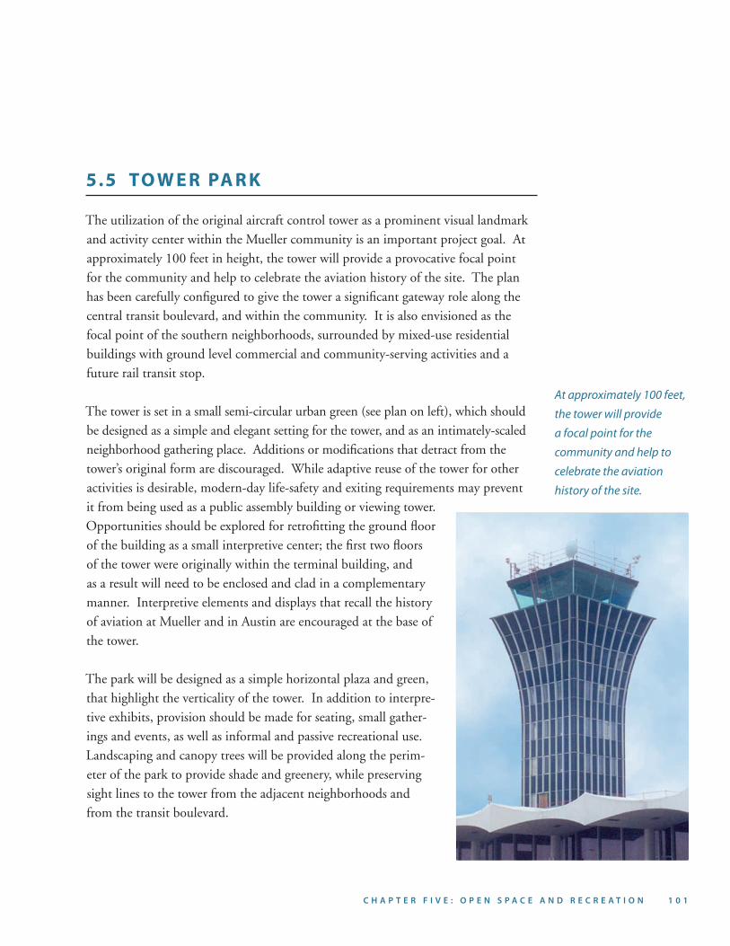
At approximately 100 feet,
the tower will provide
a focal point for the
community and help to
celebrate the aviation
history of the site.
5.5 TO W E R PA R K
The utilization of the original aircraft control tower as a prominent visual landmark and activity center within the Mueller community is an important project goal. At approximately 100 feet in height, the tower will provide a provocative focal point for the community and help to celebrate the aviation history of the site. The plan has been carefully configured to give the tower a significant gateway role along the central transit boulevard, and within the community. It is also envisioned as the focal point of the southern neighborhoods, surrounded by mixed-use residential buildings with ground level commercial and community-serving activities and a future rail transit stop.
The tower is set in a small semi-circular urban green (see plan on left), which should be designed as a simple and elegant setting for the tower, and as an intimately-scaled neighborhood gathering place. Additions or modifications that detract from the tower’s original form are discouraged. While adaptive reuse of the tower for other activities is desirable, modern-day life-safety and exiting requirements may prevent it from being used as a public assembly building or viewing tower. Opportunities should be explored for retrofitting the ground floor of the building as a small interpretive center; the first two floors of the tower were originally within the terminal building, and as a result will need to be enclosed and clad in a complementary manner. Interpretive elements and displays that recall the history of aviation at Mueller and in Austin are encouraged at the base of the tower.
The park will be designed as a simple horizontal plaza and green, that highlight the verticality of the tower. In addition to interpre-tive exhibits, provision should be made for seating, small gather-ings and events, as well as informal and passive recreational use. Landscaping and canopy trees will be provided along the perim-eter of the park to provide shade and greenery, while preserving sight lines to the tower from the adjacent neighborhoods and from the transit boulevard.
1 0 2 M U E L L E R D E S I G N B O O K • N O V E M B E R 2 0 0 4 C H A P T E R S I X : L A N D S C A P E A N D S T R E E T S C A P E 1 0 3
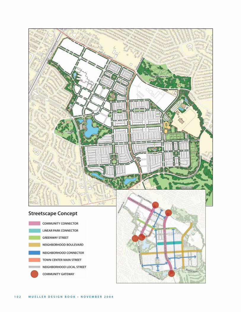
Streetscape Concept