Embed Size (px)
Citation preview

5E Lesson 5 Plate Boundary Manipulation- Science
Name: Jeanette Fehr Date: July 20, 2011
Content Area: Earth Sci. Grade Level(s): 9+ Topic(s): Plate Tectonics
Standards (SOL)
Earth Science SOL StandardES.1c,fES.7a,bES.5a,b,c rock
Objectives (UKD’s)
Students should be able to:1) Use provided manipulative to demonstrate knowledge and understanding
of plate movement found along tectonic boundaries2) Model the geologic features corresponding to different plate boundary
movement 3) Using appropriate hand gestures develop a memorable way to
differentiate between the three types of plate boundaries. (--not limited to just hands…)
Materials & Resources
The amount of materials needed will depend on the number of student packets made. (Suggestion 16 packets for paired groups or 32+ for individuals)*The list below is a suggestion per packet:
1) 1 Copy paper box (great for storing these packets)2) 1 Gallon-size Ziploc bag 3) 2 pieces of blue felt = ocean crusts4) 1 piece of blue felt (fold in half and make cuts in the middle as if a cat
clawed the center)= ocean rift valley5) 2 pieces of brown or beige felt = continental crusts6) 1 piece of beige felt (fold in half and make cuts in the middle as if a cat
clawed the center)= continental rift valley7) 1 piece of pink felt = Asthenosphere / Lithosphere (optional)8) 1/3 piece of red felt (cut whole felt sheet lengthwise in thirds—some
pieces have red metallic threads woven through) = lava9) red rocks or craft beads = lava/ volcanic mountains/ volcanic islands10)1 red pipe cleaner = lava/ volcanic mountains/ volcanic islands11) 8-10 brown or beige pebbles

*Colored shower curtains from a General Dollar Store can be used instead of felt, but they it takes more time to cut them down to desk-size and they don’t last as long
~~~~~Materials needed for one of the extensions
1. sandwich cookies, individual Twizzler packs, or sugar wafers2. napkins
Haxby, Bill http://www.earthinstitute.columbia.edu/news/2004/images/2003-10- 11103ridge1.jpg Retrieved July 20, 2011
http://abyss.uoregon.edu/~js/images/plate_tectonics.gif Retrieved July 20, 2011
http://apo.cssmi.qc.ca/album/Texte_anglais/slides/oceanic_continental_convergence.jpg Retrieved July 22, 2011
http://bp1.blogger.com/_YnH2v0VU2m8/RdvLcPsMU0I/AAAAAAAAACQ/OgMofgbs7J8/s1600-h/slide0022_image014.jpg Retrieved July 22, 2011
http://4.bp.blogspot.com/_LoJv_ervCa4/SamZfgiV2I/AAAAAAAAANM/TwL0G4ixeCo/s400/Himalayan+Mts.JPG Retrieved July 22, 2011
http://clasticdetritus.files.wordpress.com/2008/11/bathy-aleutian.jpg Retrieved July 22, 2011
http://earthsciencetravels.files.wordpress.com/2011/04/transform.jpg Retrieved July 20, 2011
http://fc00.deviantart.net/fs28/i/2008/055/8/5/Himalaya__Mountains_5_by_CitizenFresh.jpg Retrieved July 22, 2011 http://media-1.web.britannica.com/eb-media/71/3171-003-6F4C69C0.gif Retrieved July 20, 2011
http://platetectonics.pwnet.org/img/pinatubo.jpg Retrieved July 22, 2011
http://pubs.usgs.gov/gip/dynamic/graphics/San_Andreas.gif Retrieved July 20, 2011http://sdsugeology.blogspot.com/2007_02_01_archive.html Retrieved July 22, 2011
http://skywalker.cochise.edu/wellerr/students/california-falling/project_files/image020.jpg Retrieved July 22, 2011
http://upload.wikimedia.org/wikipedia/commons/thumb/a/ab/Iceland_Mid-Atlantic_Ridge_Fig16.gif/200px-Iceland_Mid-Atlantic_Ridge_Fig16.gif Retrieved July 20, 2011
http://www.alfilodelocutre.net/FOTOGRAFIAS/galeria/aconcagua.jpg Retrieved July 22, 2011
http://www.bing.com/images/search?q=convergent+plate+boundary&view=detail&id=DF5AD74CD616CC12B44D3A7AAA8A9235D6E3DD20&first=0&FORM=IDFRIR Retrieved July 22, 2011
http://www.ck12.org/ck12/images?id=309255 Retrieved July 22, 2011
http://www.ck12.org/ck12/images?id=309254 Retrieved July 22, 2011

http://www.daleeasley.com/resources/Essays/EastAfricanRift.html Retrieved July 22, 2011http://www.enotes.com/topic/Submarine_earthquake Retrieved July 22, 2011
http://www.platetectonics.com/oceanfloors/images/Africa-South_America_4.jpg Retrieved July 20, 2011
http://www.travelblog.org/Photos/1831621 Retrieved July 22, 2011
http://www.williamjosephgallery.com/images/Artworks/WoodjpgEmailReady/Wood%203666-Fire%20and%20Ice-Cascade%20Range-Oregon-Mountains%20Volcano%203.JPG Retrieved July 22, 2011
http://www.wolaver.org/Space/Cleveland_volcano.jpg Retrieved July 22, 2011
This activity was something I thought-up in desperation to make some abstract concepts come to life in student’s hands. The pieces are large enough that the teacher can pretty much observe all the students simultaneously.
Safety Considerations
The only possible hazard in this activity would be the small red craft beads. If they fall on the floor & not recovered, someone could potentially slip when walking.~~*Prior to using the edible extension activity, determine if students have allergies to milk or wheat products. This activity is not recommended for those students. Sometimes their favorite snack can be substituted.
Engage – Time Estimate 5+ minutes
I have a tee-shirt with plate boundaries that I wear for this activity (overtop professional clothes).
Think-Pair-Share with seat/shoulder buddy: What are the three major types of plate boundaries & what crustal motions are associated with each type? What major rock is associated with the ocean crust? What rock is associated with the inner mountain cores? What creates volcanism?
Explore – Time Estimate 10-15 minutesActivities, labs, sequence, scripts, questions: include lesson design components here as well as groupings or cooperative learning strategies, and details of the science concepts involved in the lesson.
Using slide #2 Lesson 5 Plate Manipulations PowerPoint, tell the students that they are going to use the objects in the Ziploc bag to represent tectonic plate boundaries, the movement, and geologic features that are associated with the

boundaries.Review the color code found in the key & note that some of the shades
they have on their desk may be a little different.The PowerPoint provides a ‘scripted direction beginning on slide #3
followed by two possible outcomes students may provide with their manipulative (answers are not limited to those provided, students can be creative with their supplies; just the basics answers provided.)
1) Stay together as a class and create:2) Demonstrate a Transform Fault Boundary on land
Where can we find an example of this type of boundary?San Andreas Fault, CA
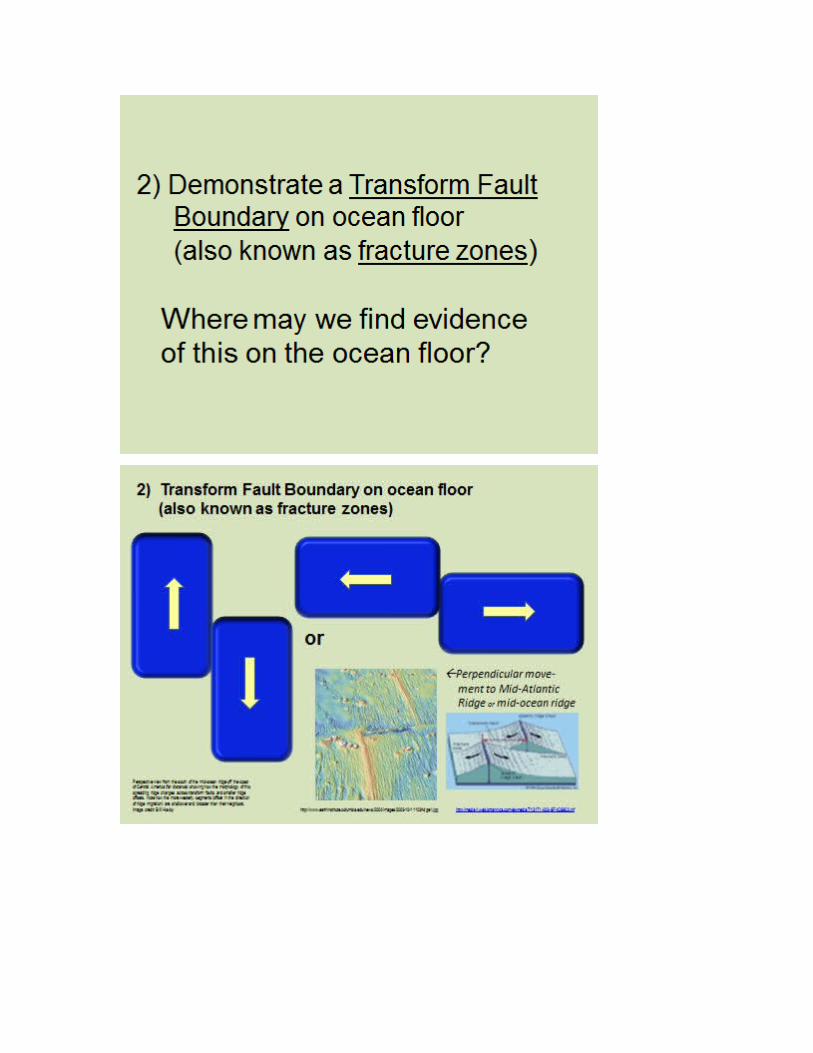
3) 2) Demonstrate a Transform Fault Boundary on ocean floor (also called fracture zones). Where may we find evidence of this on the ocean floor?
Perpendicular movement to ocean ridges 4) Demonstrate a Divergent Boundary on the ocean floor
Where would we see evidence of this on the ocean floor? Mid-Atlantic Ridge
5) Demonstrate a Divergent B boundary on land?Where would we see evidence of this in USA? How about Africa?
Death Valley, USA & East African Rift, Africa 6) Demonstrate a Continental-Continental Convergent Boundary
Where in the world is there continuous evidence of convergent boundaries interacting?
Himalayas 7) Demonstrate a Oceanic-Continental Convergent Boundary
Where in the USA can we find evidence of Oceanic-Continental Convergence? Other locations? Juan de Fuca Plate-North American Plate Nazca Plate—South American Plate
Explain -- Time Estimate 10-15 minutes
Teachers should circulate around the classroom & observe the students working the manipulatives. One of the tricky spots for kids is the oceanic conversions involving subduction. This is a great opportunity to work-in the density differences from the rock chapter. The denser basaltic ocean more is subducted beneath overlying granitic continental crust. Sometimes they will misplace the ‘red volcanoes’; the volcanoes should be place on the overriding plate, not the subducted one. Oceanic-oceanic convergence should have more of a volcanic island arc-shape to it.
Extend -- Time Estimate 15-20 minutes
Students will be asked to work with a friend or seat partner to develop a memorable way to differentiate between the three types of plate boundaries using appropriate hand gestures. This is not to limit them to just hands; they can develop a rap song, a poem…anything that will help them remember the motions associated with the movements along plate boundaries. (If the hands can simulate the motions, then they have a ‘quite, mini activity’ to reflect upon when they see a related SOL question).
Additional questions about the rock types can be added throughout the slides. Where would metamorphic rock be found in an oceanic-convergences? Explain why there is volcanism near subduction zones. Explain what causes volcanoes along the subduction zones to be more explosive than volcanoes along divergent boundaries?
Students can also be offered edible manipulatives: sandwich cookies, individual Twizzler packs, sugar wafers. Use the same directions as in Explore section above.
The students can be asked to sketch and label the different plate boundaries using their favorite cookie(s) or candy bars, or sometimes snack food.
Evaluate -- Time Estimate 10-15 minutes
How will you know students' met the objectives? The pieces are large enough that a teacher can observe all the students
simultaneously especially when circulating around the class.When the students share the creative activity with their hands and explain
to the class what each motion represents, teachers can asses if the students have properly made the connection bring the abstract concepts to life.
Estimate 20-30 minutesA summative assessment can be give to assess students’ understanding
of the concepts. This should not be done on the same day.
Plans for Diversity Student(s): Category/Characteristics: Accommodations:
Students who have a stronger understanding of plate movement may be paired with those students with a weaker understanding, students who are easily frustrated, or who may have an attention deficiency.
Students stronger with scientific terminology and vocabulary usage may be pair with students with lower reading skills or ELL students.
Some students may still need a ‘re-teaching’. Students ‘connect with

food’; it makes their experience more meaningful and memorable. Teachers can have students work with the snack of their choice, two magazines, two comic books, etc. and follow some of the basics of the script. The students can use their selected items to demonstrate the motions along the plate boundaries.
Connections
This lesson supports the Unit on Plate Tectonics especially the chapters discussing the specific plate boundaries. It also scaffolds in the rock chapter differentiating between composition and densities of the oceanic and continental crust. Animations & diagrams are super, but there is no substitute for the tactile learning that can connect the abstract concepts to something that is familiar to students. Hence the food products; students in general have a special connection to food.
In our scope and sequence, we are expected to cover plate tectonics during the second quarter; it follows the unit on rocks, weathering & erosion. It can be reflected upon in future chapters relating to geologic history and Virginia geology taught during third quarter or during the oceanography unit taught fourth quarter.