Embed Size (px)
Citation preview
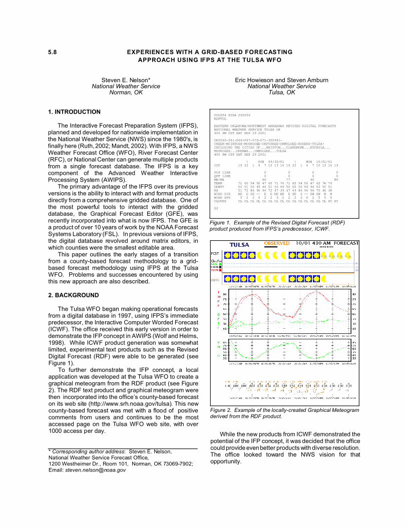
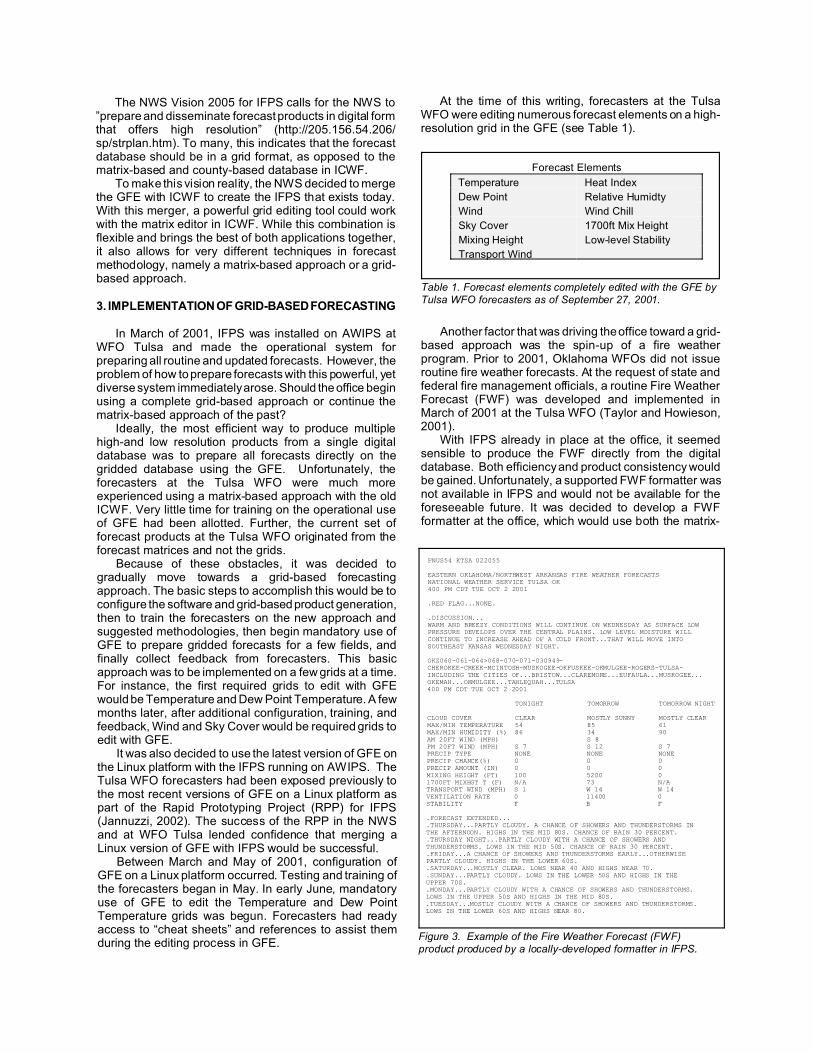
Figure 2. Example of the locally-created Graphical Meteogramderived from the RDF product.
FOUS54 KTSA 292056RDFTUL
EASTERN OKLAHOMA/NORTHWEST ARKANSAS REVISED DIGITAL FORECASTSNATIONAL WEATHER SERVICE TULSA OK400 PM CDT SAT SEP 29 2001
OKZ060-061-064>067-070-071-300941-CREEK-MCINTOSH-MUSKOGEE-OKFUSKEE-OKMULGEE-ROGERS-TULSA-INCLUDING THE CITIES OF...BRISTOW...CLAREMORE...EUFAULA...MUSKOGEE...OKEMAH...OKMULGEE...TULSA400 PM CDT SAT SEP 29 2001
\ SUN 09/30/01 \ MON 10/01/01CDT 19 22 1 4 7 10 13 16 19 22 1 4 7 10 13 16 19
POP 12HR 0 0 0 0QPF 12HR 0 0 0 0MN/MX 46 77 46 80TEMP 71 60 54 50 47 60 71 76 71 60 54 50 47 62 74 79DEWPT 52 51 50 49 46 51 50 49 50 50 50 49 46 52 52 51RH 51 72 86 96 96 72 47 39 47 69 86 96 96 70 46 38WIND DIR NE E SE -- E E NE NE E SE S -- SW SW W WWIND SPD 5 2 2 0 2 2 5 2 2 2 2 0 2 5 5 5CLOUDS CL CL CL CL CL CL CL CL CL CL CL CL CL CL CL SC SC
$$
Figure 1. Example of the Revised Digital Forecast (RDF) product produced from IFPS’s predecessor, ICWF.
5.8 EXPERIENCES WITH A GRID-BASED FORECASTING
APPROACH USING IFPS AT THE TULSA WFO
Steven E. Nelson*National Weather Service
Norman, OK
Eric Howieson and Steven AmburnNational Weather Service
Tulsa, OK
1. INTRODUCTION
The Interactive Forecast Preparation System (IFPS),planned and developed for nationwide implementation inthe National Weather Service (NWS) since the 1980's, isfinally here (Ruth, 2002; Mandt, 2002). With IFPS, a NWSWeather Forecast Office (WFO), River Forecast Center(RFC), or National Center can generate multiple productsfrom a single forecast database. The IFPS is a keycomponent of the Advanced Weather InteractiveProcessing System (AWIPS).
The primary advantage of the IFPS over its previousversions is the ability to interact with and format productsdirectly from a comprehensive gridded database. One ofthe most powerful tools to interact with the griddeddatabase, the Graphical Forecast Editor (GFE), wasrecently incorporated into what is now IFPS. The GFE isa product of over 10 years of work by the NOAA ForecastSystems Laboratory (FSL). In previous versions of IFPS,the digital database revolved around matrix editors, inwhich counties were the smallest editable area.
This paper outlines the early stages of a transitionfrom a county-based forecast methodology to a grid-based forecast methodology using IFPS at the TulsaWFO. Problems and successes encountered by usingthis new approach are also described.
2. BACKGROUND
The Tulsa WFO began making operational forecastsfrom a digital database in 1997, using IFPS’s immediatepredecessor, the Interactive Computer Worded Forecast(ICWF). The office received this early version in order todemonstrate the IFP concept in AWIPS (Wolf and Helms,1998). While ICWF product generation was somewhatlimited, experimental text products such as the RevisedDigital Forecast (RDF) were able to be generated (seeFigure 1).
To further demonstrate the IFP concept, a localapplication was developed at the Tulsa WFO to create agraphical meteogram from the RDF product (see Figure2). The RDF text product and graphical meteogram werethen incorporated into the office’s county-based forecaston its web site (http://www.srh.noaa.gov/tulsa). This newcounty-based forecast was met with a flood of positivecomments from users and continues to be the mostaccessed page on the Tulsa WFO web site, with over1000 access per day.
* Corresponding author address: Steven E. Nelson, National Weather Service Forecast Office, 1200 Westheimer Dr., Room 101, Norman, OK 73069-7902; Email: [email protected]
While the new products from ICWF demonstrated thepotential of the IFP concept, it was decided that the officecould provide even better products with diverse resolution.The office looked toward the NWS vision for thatopportunity.
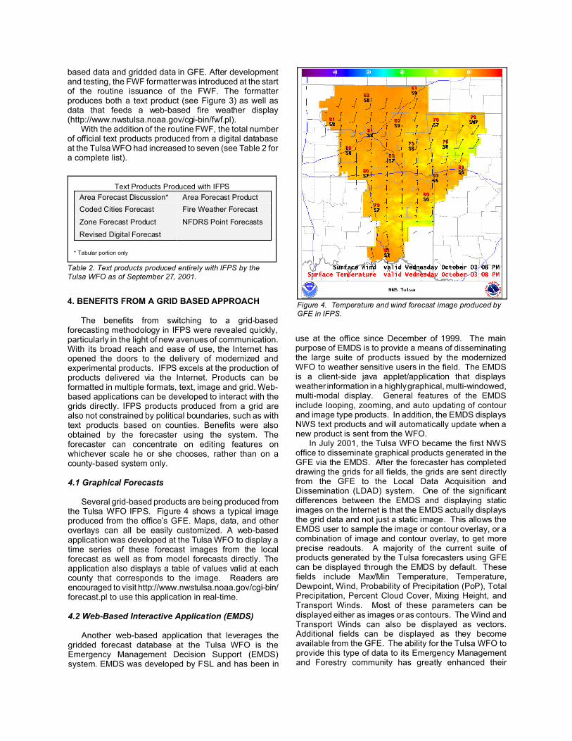
FNUS54 KTSA 022055
EASTERN OKLAHOMA/NORTHWEST ARKANSAS FIRE WEATHER FORECASTSNATIONAL WEATHER SERVICE TULSA OK400 PM CDT TUE OCT 2 2001
.RED FLAG...NONE.
.DISCUSSION...WARM AND BREEZY CONDITIONS WILL CONTINUE ON WEDNESDAY AS SURFACE LOW PRESSURE DEVELOPS OVER THE CENTRAL PLAINS. LOW LEVEL MOISTURE WILL CONTINUE TO INCREASE AHEAD OF A COLD FRONT...THAT WILL MOVE INTO SOUTHEAST KANSAS WEDNESDAY NIGHT.
OKZ060-061-064>068-070-071-030949-CHEROKEE-CREEK-MCINTOSH-MUSKOGEE-OKFUSKEE-OKMULGEE-ROGERS-TULSA-INCLUDING THE CITIES OF...BRISTOW...CLAREMORE...EUFAULA...MUSKOGEE...OKEMAH...OKMULGEE...TAHLEQUAH...TULSA400 PM CDT TUE OCT 2 2001
TONIGHT TOMORROW TOMORROW NIGHT
CLOUD COVER CLEAR MOSTLY SUNNY MOSTLY CLEAR MAX/MIN TEMPERATURE 54 85 61 MAX/MIN HUMIDITY (%) 86 34 90 AM 20FT WIND (MPH) S 8 PM 20FT WIND (MPH) S 7 S 12 S 7 PRECIP TYPE NONE NONE NONE PRECIP CHANCE(%) 0 0 0 PRECIP AMOUNT (IN) 0 0 0 MIXING HEIGHT (FT) 100 5200 0 1700FT MIXHGT T (F) N/A 73 N/A TRANSPORT WIND (MPH) S 1 W 14 W 14 VENTILATION RATE 0 11400 0 STABILITY F B F .FORECAST EXTENDED....THURSDAY...PARTLY CLOUDY. A CHANCE OF SHOWERS AND THUNDERSTORMS IN THE AFTERNOON. HIGHS IN THE MID 80S. CHANCE OF RAIN 30 PERCENT. .THURSDAY NIGHT...PARTLY CLOUDY WITH A CHANCE OF SHOWERS AND THUNDERSTORMS. LOWS IN THE MID 50S. CHANCE OF RAIN 30 PERCENT. .FRIDAY...A CHANCE OF SHOWERS AND THUNDERSTORMS EARLY...OTHERWISE PARTLY CLOUDY. HIGHS IN THE LOWER 60S. .SATURDAY...MOSTLY CLEAR. LOWS NEAR 40 AND HIGHS NEAR 70. .SUNDAY...PARTLY CLOUDY. LOWS IN THE LOWER 50S AND HIGHS IN THE UPPER 70S. .MONDAY...PARTLY CLOUDY WITH A CHANCE OF SHOWERS AND THUNDERSTORMS. LOWS IN THE UPPER 50S AND HIGHS IN THE MID 80S. .TUESDAY...MOSTLY CLOUDY WITH A CHANCE OF SHOWERS AND THUNDERSTORMS. LOWS IN THE LOWER 60S AND HIGHS NEAR 80.
Figure 3. Example of the Fire Weather Forecast (FWF) product produced by a locally-developed formatter in IFPS.
Forecast Elements
Temperature Heat Index
Dew Point Relative Humidty
Wind Wind Chill
Sky Cover 1700ft Mix Height
Mixing Height Low-level Stability
Transport Wind
Table 1. Forecast elements completely edited with the GFE byTulsa WFO forecasters as of September 27, 2001.
The NWS Vision 2005 for IFPS calls for the NWS to”prepare and disseminate forecast products in digital formthat offers high resolution” (http://205.156.54.206/sp/strplan.htm). To many, this indicates that the forecastdatabase should be in a grid format, as opposed to thematrix-based and county-based database in ICWF.
To make this vision reality, the NWS decided to mergethe GFE with ICWF to create the IFPS that exists today.With this merger, a powerful grid editing tool could workwith the matrix editor in ICWF. While this combination isflexible and brings the best of both applications together,it also allows for very different techniques in forecastmethodology, namely a matrix-based approach or a grid-based approach.
3. IMPLEMENTATION OF GRID-BASED FORECASTING
In March of 2001, IFPS was installed on AWIPS atWFO Tulsa and made the operational system forpreparing all routine and updated forecasts. However, theproblem of how to prepare forecasts with this powerful, yetdiverse system immediately arose. Should the office beginusing a complete grid-based approach or continue thematrix-based approach of the past?
Ideally, the most efficient way to produce multiplehigh-and low resolution products from a single digitaldatabase was to prepare all forecasts directly on thegridded database using the GFE. Unfortunately, theforecasters at the Tulsa WFO were much moreexperienced using a matrix-based approach with the oldICWF. Very little time for training on the operational useof GFE had been allotted. Further, the current set offorecast products at the Tulsa WFO originated from theforecast matrices and not the grids.
Because of these obstacles, it was decided togradually move towards a grid-based forecastingapproach. The basic steps to accomplish this would be toconfigure the software and grid-based product generation,then to train the forecasters on the new approach andsuggested methodologies, then begin mandatory use ofGFE to prepare gridded forecasts for a few fields, andfinally collect feedback from forecasters. This basicapproach was to be implemented on a few grids at a time.For instance, the first required grids to edit with GFEwould be Temperature and Dew Point Temperature. A fewmonths later, after additional configuration, training, andfeedback, Wind and Sky Cover would be required grids toedit with GFE.
It was also decided to use the latest version of GFE onthe Linux platform with the IFPS running on AWIPS. TheTulsa WFO forecasters had been exposed previously tothe most recent versions of GFE on a Linux platform aspart of the Rapid Prototyping Project (RPP) for IFPS(Jannuzzi, 2002). The success of the RPP in the NWSand at WFO Tulsa lended confidence that merging aLinux version of GFE with IFPS would be successful.
Between March and May of 2001, configuration ofGFE on a Linux platform occurred. Testing and training ofthe forecasters began in May. In early June, mandatoryuse of GFE to edit the Temperature and Dew PointTemperature grids was begun. Forecasters had readyaccess to “cheat sheets” and references to assist themduring the editing process in GFE.
At the time of this writing, forecasters at the TulsaWFO were editing numerous forecast elements on a high-resolution grid in the GFE (see Table 1).
Another factor that was driving the office toward a grid-based approach was the spin-up of a fire weatherprogram. Prior to 2001, Oklahoma WFOs did not issueroutine fire weather forecasts. At the request of state andfederal fire management officials, a routine Fire WeatherForecast (FWF) was developed and implemented inMarch of 2001 at the Tulsa WFO (Taylor and Howieson,2001).
With IFPS already in place at the office, it seemedsensible to produce the FWF directly from the digitaldatabase. Both efficiency and product consistency wouldbe gained. Unfortunately, a supported FWF formatter wasnot available in IFPS and would not be available for theforeseeable future. It was decided to develop a FWFformatter at the office, which would use both the matrix-
Text Products Produced with IFPS
Area Forecast Discussion* Area Forecast Product
Coded Cities Forecast Fire Weather Forecast
Zone Forecast Product NFDRS Point Forecasts
Revised Digital Forecast
* Tabular portion only
Table 2. Text products produced entirely with IFPS by theTulsa WFO as of September 27, 2001.
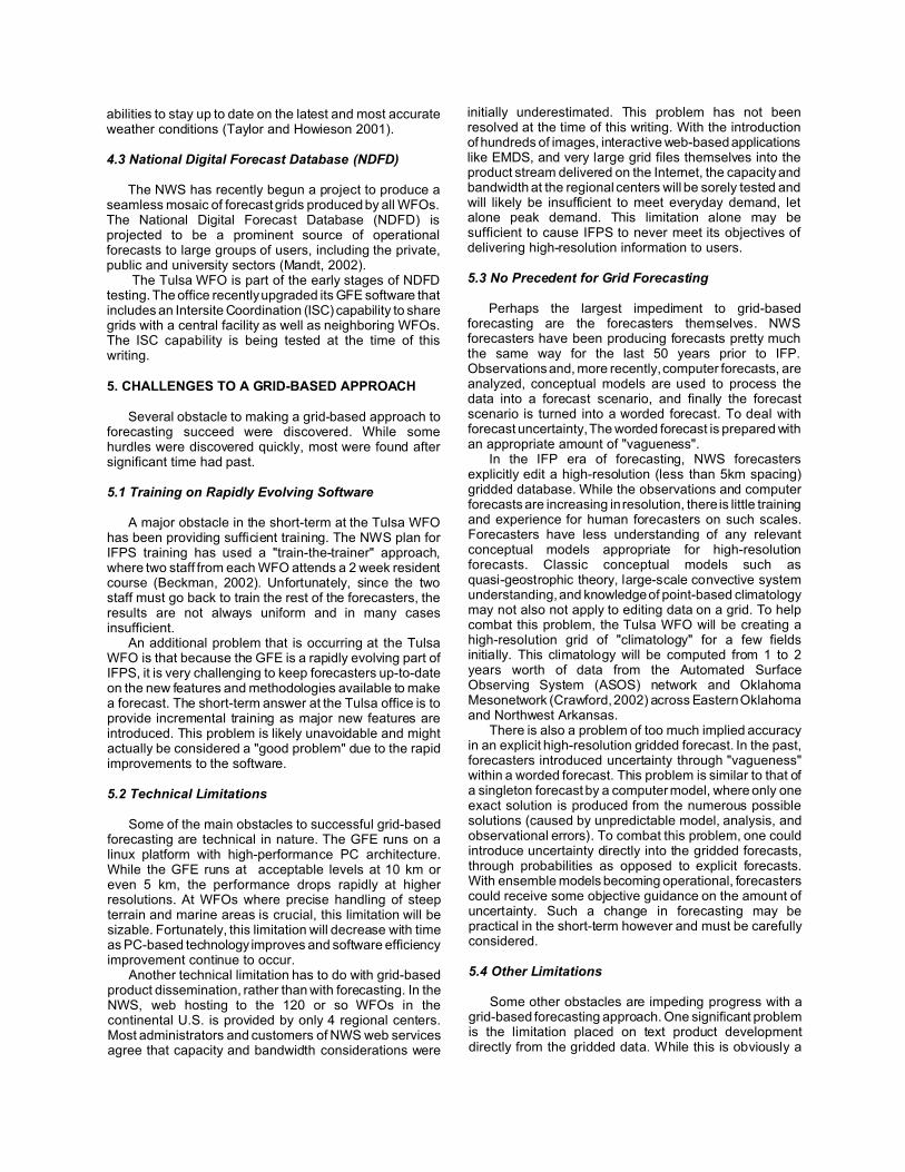
Figure 4. Temperature and wind forecast image produced by GFE in IFPS.
based data and gridded data in GFE. After developmentand testing, the FWF formatter was introduced at the startof the routine issuance of the FWF. The formatterproduces both a text product (see Figure 3) as well asdata that feeds a web-based fire weather display(http://www.nwstulsa.noaa.gov/cgi-bin/fwf.pl).
With the addition of the routine FWF, the total numberof official text products produced from a digital databaseat the Tulsa WFO had increased to seven (see Table 2 fora complete list).
4. BENEFITS FROM A GRID BASED APPROACH
The benefits from switching to a grid-basedforecasting methodology in IFPS were revealed quickly,particularly in the light of new avenues of communication.With its broad reach and ease of use, the Internet hasopened the doors to the delivery of modernized andexperimental products. IFPS excels at the production ofproducts delivered via the Internet. Products can beformatted in multiple formats, text, image and grid. Web-based applications can be developed to interact with thegrids directly. IFPS products produced from a grid arealso not constrained by political boundaries, such as withtext products based on counties. Benefits were alsoobtained by the forecaster using the system. Theforecaster can concentrate on editing features onwhichever scale he or she chooses, rather than on acounty-based system only.
4.1 Graphical Forecasts
Several grid-based products are being produced fromthe Tulsa WFO IFPS. Figure 4 shows a typical imageproduced from the office’s GFE. Maps, data, and otheroverlays can all be easily customized. A web-basedapplication was developed at the Tulsa WFO to display atime series of these forecast images from the localforecast as well as from model forecasts directly. Theapplication also displays a table of values valid at eachcounty that corresponds to the image. Readers areencouraged to visit http://www.nwstulsa.noaa.gov/cgi-bin/forecast.pl to use this application in real-time.
4.2 Web-Based Interactive Application (EMDS)
Another web-based application that leverages thegridded forecast database at the Tulsa WFO is theEmergency Management Decision Support (EMDS)system. EMDS was developed by FSL and has been in
use at the office since December of 1999. The mainpurpose of EMDS is to provide a means of disseminatingthe large suite of products issued by the modernizedWFO to weather sensitive users in the field. The EMDSis a client-side java applet/application that displaysweather information in a highly graphical, multi-windowed,multi-modal display. General features of the EMDSinclude looping, zooming, and auto updating of contourand image type products. In addition, the EMDS displaysNWS text products and will automatically update when anew product is sent from the WFO.
In July 2001, the Tulsa WFO became the first NWSoffice to disseminate graphical products generated in theGFE via the EMDS. After the forecaster has completeddrawing the grids for all fields, the grids are sent directlyfrom the GFE to the Local Data Acquisition andDissemination (LDAD) system. One of the significantdifferences between the EMDS and displaying staticimages on the Internet is that the EMDS actually displaysthe grid data and not just a static image. This allows theEMDS user to sample the image or contour overlay, or acombination of image and contour overlay, to get moreprecise readouts. A majority of the current suite ofproducts generated by the Tulsa forecasters using GFEcan be displayed through the EMDS by default. Thesefields include Max/Min Temperature, Temperature,Dewpoint, Wind, Probability of Precipitation (PoP), TotalPrecipitation, Percent Cloud Cover, Mixing Height, andTransport Winds. Most of these parameters can bedisplayed either as images or as contours. The Wind andTransport Winds can also be displayed as vectors.Additional fields can be displayed as they becomeavailable from the GFE. The ability for the Tulsa WFO toprovide this type of data to its Emergency Managementand Forestry community has greatly enhanced their
abilities to stay up to date on the latest and most accurateweather conditions (Taylor and Howieson 2001).
4.3 National Digital Forecast Database (NDFD)
The NWS has recently begun a project to produce aseamless mosaic of forecast grids produced by all WFOs.The National Digital Forecast Database (NDFD) isprojected to be a prominent source of operationalforecasts to large groups of users, including the private,public and university sectors (Mandt, 2002).
The Tulsa WFO is part of the early stages of NDFDtesting. The office recently upgraded its GFE software thatincludes an Intersite Coordination (ISC) capability to sharegrids with a central facility as well as neighboring WFOs.The ISC capability is being tested at the time of thiswriting.
5. CHALLENGES TO A GRID-BASED APPROACH
Several obstacle to making a grid-based approach toforecasting succeed were discovered. While somehurdles were discovered quickly, most were found aftersignificant time had past.
5.1 Training on Rapidly Evolving Software
A major obstacle in the short-term at the Tulsa WFOhas been providing sufficient training. The NWS plan forIFPS training has used a "train-the-trainer" approach,where two staff from each WFO attends a 2 week residentcourse (Beckman, 2002). Unfortunately, since the twostaff must go back to train the rest of the forecasters, theresults are not always uniform and in many casesinsufficient.
An additional problem that is occurring at the TulsaWFO is that because the GFE is a rapidly evolving part ofIFPS, it is very challenging to keep forecasters up-to-dateon the new features and methodologies available to makea forecast. The short-term answer at the Tulsa office is toprovide incremental training as major new features areintroduced. This problem is likely unavoidable and mightactually be considered a "good problem" due to the rapidimprovements to the software.
5.2 Technical Limitations
Some of the main obstacles to successful grid-basedforecasting are technical in nature. The GFE runs on alinux platform with high-performance PC architecture.While the GFE runs at acceptable levels at 10 km oreven 5 km, the performance drops rapidly at higherresolutions. At WFOs where precise handling of steepterrain and marine areas is crucial, this limitation will besizable. Fortunately, this limitation will decrease with timeas PC-based technology improves and software efficiencyimprovement continue to occur.
Another technical limitation has to do with grid-basedproduct dissemination, rather than with forecasting. In theNWS, web hosting to the 120 or so WFOs in thecontinental U.S. is provided by only 4 regional centers.Most administrators and customers of NWS web servicesagree that capacity and bandwidth considerations were
initially underestimated. This problem has not beenresolved at the time of this writing. With the introductionof hundreds of images, interactive web-based applicationslike EMDS, and very large grid files themselves into theproduct stream delivered on the Internet, the capacity andbandwidth at the regional centers will be sorely tested andwill likely be insufficient to meet everyday demand, letalone peak demand. This limitation alone may besufficient to cause IFPS to never meet its objectives ofdelivering high-resolution information to users.
5.3 No Precedent for Grid Forecasting
Perhaps the largest impediment to grid-basedforecasting are the forecasters themselves. NWSforecasters have been producing forecasts pretty muchthe same way for the last 50 years prior to IFP.Observations and, more recently, computer forecasts, areanalyzed, conceptual models are used to process thedata into a forecast scenario, and finally the forecastscenario is turned into a worded forecast. To deal withforecast uncertainty, The worded forecast is prepared withan appropriate amount of "vagueness".
In the IFP era of forecasting, NWS forecastersexplicitly edit a high-resolution (less than 5km spacing)gridded database. While the observations and computerforecasts are increasing in resolution, there is little trainingand experience for human forecasters on such scales.Forecasters have less understanding of any relevantconceptual models appropriate for high-resolutionforecasts. Classic conceptual models such asquasi-geostrophic theory, large-scale convective systemunderstanding, and knowledge of point-based climatologymay not also not apply to editing data on a grid. To helpcombat this problem, the Tulsa WFO will be creating ahigh-resolution grid of "climatology" for a few fieldsinitially. This climatology will be computed from 1 to 2years worth of data from the Automated SurfaceObserving System (ASOS) network and OklahomaMesonetwork (Crawford, 2002) across Eastern Oklahomaand Northwest Arkansas.
There is also a problem of too much implied accuracyin an explicit high-resolution gridded forecast. In the past,forecasters introduced uncertainty through "vagueness"within a worded forecast. This problem is similar to that ofa singleton forecast by a computer model, where only oneexact solution is produced from the numerous possiblesolutions (caused by unpredictable model, analysis, andobservational errors). To combat this problem, one couldintroduce uncertainty directly into the gridded forecasts,through probabilities as opposed to explicit forecasts.With ensemble models becoming operational, forecasterscould receive some objective guidance on the amount ofuncertainty. Such a change in forecasting may bepractical in the short-term however and must be carefullyconsidered.
5.4 Other Limitations
Some other obstacles are impeding progress with agrid-based forecasting approach. One significant problemis the limitation placed on text product developmentdirectly from the gridded data. While this is obviously a
desirable feature and in many ways superior tocounty-based (matrix-based) text products, developmenthas been slowed. Freeing up all possible ways to produceproducts from the high-resolution data directly will helpencourage forecasters to do their work in the grids. It willalso improve product quality.
6. SUMMARY
The early stages of the implementation of IFPS at theTulsa WFO are described, and in particular the transitionto a grid-based forecast methodology. While there aresignificant obstacles, it is hoped they will eventually beovercome. Indeed, if this forecasting methodology cansucceed, no longer will NWS products be constrained tocounty-based, low-resolution text products. A wealth ofinformation in various formats can easily be provided tousers of different needs -- all from a single high-resolutiondatabase.
7. ACKNOWLEDGMENTS
The authors would like to recognize the hard work ofthe NWS Meteorological Development Laboratory (MDL)and the NOAA FSL. In particular, Mark Mathewson of theExperimental Forecasting Techniques (EFT) branch atFSL, provided outstanding support and training on theGFE for the Tulsa WFO and numerous other field offices.Mr. Mathewson and his team made outstandingcontributions by working closely with the WFOs and NWSadministrators. Lastly, the forecasters of the Tulsa WFOare to be commended for their willingness to show thepotential of the IFP concept in AWIPS. The dedicationand contributions of the forecasters are the primaryreason for the success of the GFE and IFPS at the Tulsaoffice.
8. REFERENCES
Beckman, S., 2002: IFPS focal point training at the NWStraining center. 1st Interactive Symposium on AWIPS(Orlando, FL), AMS, this volume.
Crawford, K., R. McPherson, and R. Elliott, 2002: TheOklahoma Mesonetwork: Ten years later. 18thInternational Conference on Interactive Informationand Processing Systems for Meteorology,Oceanography, and Hydrology, (Orlando, FL), AMS.
Jannuzzi, J., 2002: Rapid prototyping grid-basedforecasting. 1st Interactive Symposium on AWIPS(Orlando, FL), AMS, this volume.
Mandt, G., 2002: Digital forecast technology: NWS visionfor new products and customer partnerships. 1st
Interactive Symposium on AWIPS (Orlando, FL),AMS, this volume.
Ruth, D., 2002: Interactive Forecast Preparation - Thefuture has come. 1st Interactive Symposium on AWIPS(Orlando, FL), AMS, this volume.
Taylor, S., and E. Howieson, 2001: A new approach to fireweather forecasting at the Tulsa WFO. 4thSymposium on Fire and Forest Meteorology (Reno,NV), AMS.
Wolf, W., and D. Helms, 1998: Risk reduction/evaluationof Interactive Forecast Preparation tools in the nationweather service--preparing for nationwideimplementation, 14th International Conference onInteractive Information and Processing Systems forMeteorology, Oceanography, and Hydrology,(Phoenix, AZ), AMS.