Embed Size (px)
Citation preview

plate 57. ORONCE FINE, RECENS ET INTEGRA ORBIS DESCRIPTIO, 1534/1536. (See p. 1465.) Wood engraving with watercolor (Paris, Jérôme de Gourmont).
Size of the original: 51 X 57 cm. Photograph courtesy of the BNF (Cartes et Plans, Rés. Ge DD 2987 [63]).

plate 58. ANDRÉ THEVET, ENGRAVED AND COLORED FRONTISPIECE. (See p. 1472.) Intended for “Le grand insu-laire et pilotage,” the original title is visible underneath the pasted-over new title, “Le monde maritime ov description gen-
eralle des mers & de la nauigation.”Photograph courtesy of the BNF (Estampes, Vx 1 P. 453 [col-lection Lallemant de Betz]).

plate 59. JEAN JOLIVET, “LA CARTE GENERALLE DV PAYS DE NORMANDIE,” 1545. (See p. 1484.) Manuscript on two sheets of parchment. The cartouche remains empty, its frame decorated with scientifi c instruments, the motto Moyns et Paix, and four satyr fi gures. The map has an Italian-inspired
decorative border, the names of the winds, the date, and the author’s signature.Size of the original: 92 X 137 cm. Photograph courtesy of the BNF (Cartes et Plans, Rés. Ge A 79).

plate 60. MAP FROM “LIVRE DES PLANS, DES PASSAGES ET CHAUSSÉES DE LA RIVIERE DE SOMME,” CA. 1644. (See p. 1515.) This map, made by the sieur Lenin, royal en-gineer, shows one of the many crossings of the river Somme, with a small fortress in the middle of the causeway. It shows
how the engineers of this period could design maps to cover specifi c military problems.Size of the original: 33.5 X 20 cm. Photograph courtesy of the Newberry Library, Chicago (Case MS. 5004).

plate 61. DETAIL OF THE MAP REPRESENTING THE COURSE OF THE AA RIVER, END OF THE FIFTEENTH CENTURY. (See p. 1523.) Watercolor drawing. This is an excellent example of a detailed, artistic perspective view of the topography and structures of the city of Saint-Omer, to be used in the resolution of a legal dispute. The entire map
goes from Saint-Omer to the mills of the Cistercian abbey of Blendecques.Size of the entire original: 31 X 325 cm; size of the detail: ca. 31 X 99.3 cm. Photograph courtesy of the Bibliothèque de l’Agglomération de Saint-Omer (MS. 1489).

plate 62. CHART OF THE EAST OF TERRA AUSTRA-LIS (TERRA JAVA), VALLARD ATLAS, 1547. (See p. 1555.) Sometimes the same illustration seems to appear in more than one chart. For example, the procession that is taking place in this part of the Terra Australis recalls that which Jean Rotz depicts in the representation of Sumatra in his 1542 atlas: it includes the same houses on piles, the same warriors, and the same important personage on horseback carefully shaded with
a parasol. The scene is too precisely rendered for the source to be other than an eyewitness account—perhaps the narrative of a voyage, perhaps another oral or written account, or even sketches made by one of the artists that sometimes accompanied these expeditions. Manuscript on parchment.Size of the original: 39 X 57 cm. Photography courtesy of the Huntington Library, San Marino (MS. HM 29, fols. 5v-6).
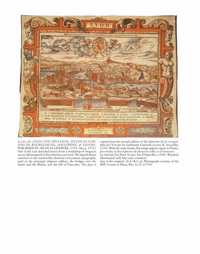
plate 63. LYON CITÉ OPULENTE, SITUÉE ES CON-FINS DE BOURGONGNE, DAULPHINÉ, & SAUOYE, PUBLISHED BY NICOLAS LEFEBVRE, 1555. (See p. 1572.) One of the rare detached leaves from a workshop of imagiers on rue Montorgueil in Paris that has survived. The legend draws attention to the noteworthy elements of Lyonnais typography, such as the principal religious edifi ces, the bridges over the Saône and the Rhône, and the hill of Fourvière. The plan is
copied from the second edition of the Epitome de la corogra-phie de l’Europe by Guillaume Guéroult (Lyons: B. Arnoullet, 1553). With the same frame, this image appears again in Plantz, povrtraitz et descriptions de plvsievrs villes et forteresses . . . by Antoine Du Pinet (Lyons: Ian d’Ogerolles, 1564). Woodcut illuminated with blue and vermilion.Size of the original: 26 X 34.5 cm. Photograph courtesy of the BNF (Cartes et Plans, Rés. Ge D 25714).
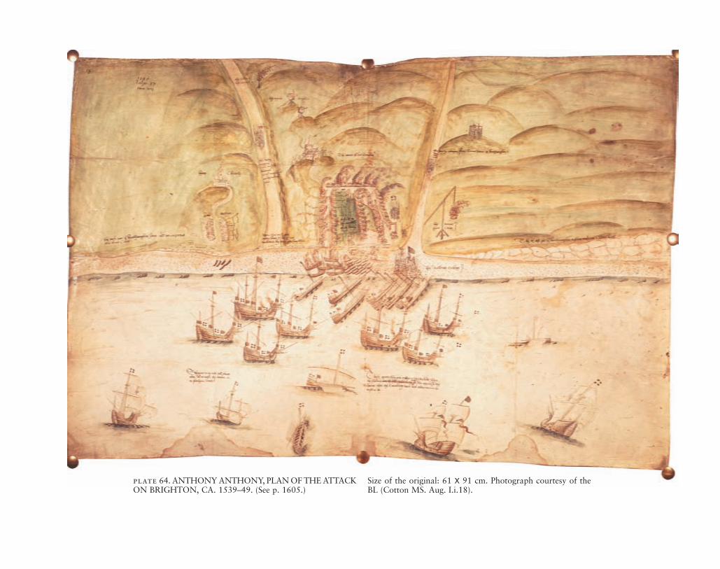
plate 64. ANTHONY ANTHONY, PLAN OF THE ATTACK ON BRIGHTON, CA. 1539–49. (See p. 1605.)
Size of the original: 61 X 91 cm. Photograph courtesy of the BL (Cotton MS. Aug. I.i.18).

plate 65. ROBERT ADAMS, MAP OF GIRONDE, 1593. (See p. 1611.)
Size of the original: 22 X 58 cm. Photograph courtesy of the BL (Cotton MS Aug. I.ii.80).
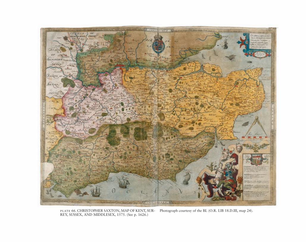
plate 66. CHRISTOPHER SAXTON, MAP OF KENT, SUR-REY, SUSSEX, AND MIDDLESEX, 1575. (See p. 1626.)
Photograph courtesy of the BL (O.R. LIB 18.D.III, map 24).

plate 67. ROBERT JOHNSON, MAP OF CRICKHOWELL. (See p. 1646.)By permission of Llyfrgell Genedlaethol Cymru / The National
Library of Wales, Aberystwyth (Badminton vol. 3, fols. 68v-69r).
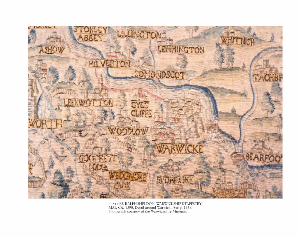
plate 68. RALPH SHELDON, WARWICKSHIRE TAPESTRY MAP, CA. 1590. Detail around Warwick. (See p. 1659.)Photograph courtesy of the Warwickshire Museum.

plate 69. MARK PIERSE, MANUSCRIPT MAP OF LAX-TON, 1635. (See p. 1662.)
Photograph courtesy of the Bodleian Library, University of Oxford (MS. C 17:48).

plate 70. DETAIL FROM RICHARD BARTLETT’S MAP OFSOUTHEAST ULSTER, CA. 1602. (See p. 1682.) Physical, polit-ical, military, and historical elements were combined in Bartlett’s mapping of Lord Mountjoy’s victorious campaign against Hugh
O’Neill in the last of Queen Elizabeth’s Irish wars. Size of the entire original: 42.9 X 55.6 cm; size of the detail: ca. 26.7 X 36 cm. Photograph courtesy of The National Archives of the UK (TNA), Kew (MPF 1/36).
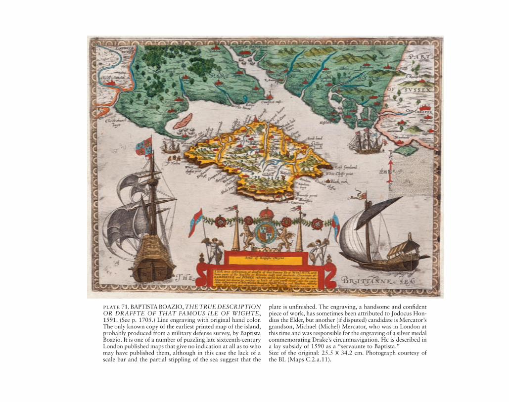
plate 71. BAPTISTA BOAZIO, THE TRUE DESCRIPTION OR DRAFFTE OF THAT FAMOUS ILE OF WIGHTE,1591. (See p. 1705.) Line engraving with original hand color. The only known copy of the earliest printed map of the island, probably produced from a military defense survey, by Baptista Boazio. It is one of a number of puzzling late sixteenth-century London published maps that give no indication at all as to who may have published them, although in this case the lack of a scale bar and the partial stippling of the sea suggest that the
plate is unfi nished. The engraving, a handsome and confi dent piece of work, has sometimes been attributed to Jodocus Hon-dius the Elder, but another (if disputed) candidate is Mercator’sgrandson, Michael (Michel) Mercator, who was in London at this time and was responsible for the engraving of a silver medal commemorating Drake’s circumnavigation. He is described in a lay subsidy of 1590 as a “servaunte to Baptista.”Size of the original: 25.5 X 34.2 cm. Photograph courtesy of the BL (Maps C.2.a.11).

plate 72. GABRIEL TATTON, CHART OF THE PACIFIC OCEAN, CA. 1600. (See p. 1742.) Drawn in the Low Countries and in the style of the Dutch. Note the signature in Dutch, and also the “lady on the armadillo” motif for America, which was
used by Dutch chartmakers (see fi gs. 58.12 and 58.13).Size of the original: 72 X 147 cm. Biblioteca Nazionale Cen-trale, Florence (Port. 33). By concession of the Ministero per i Beni e le Attività Culturali della Repubblica Italiana.

plate 73. WILLIAM DOWNE, MAP OF THE ORINOCO, GUIANA, 1596. (See p. 1767.)Private collection. Photograph courtesy of the BL.

plate 74. ANDERS STRENG, NAAPPILA AND RAJA-LAHTI, ORIVESI PARISH, FINLAND, 1634. (See p. 1804.) A sample of the fi rst generation of geometrical maps (geometriska kartor) produced by the Landmäterikontoret. The scale is in Swedish alnar (1:15,000), and color is also used. The Nota-
rum explicatio identifi es the precise features of the individual farmsteads for taxation purposes.Size of the original: 46 X 58 cm. Photograph courtesy of the Kansallisarkisto (National Archives of Finland), Helsinki (A1, pp. 226–27).

plate 75. JOHANNES HONTER’S WOODCUT BLOCKS, CA. 1541–42. (See p. 1831.) The maps of Rudimenta cosmo-graphica were cut into wood by Honter in 1541–42. Some of the original wood blocks are still preserved in Brasov. The half
of the map of Germania and Gallia, as well as the printer’s device of Honter’s workshop survive.Brasov, Romania. Photograph courtesy of Zsolt Török.
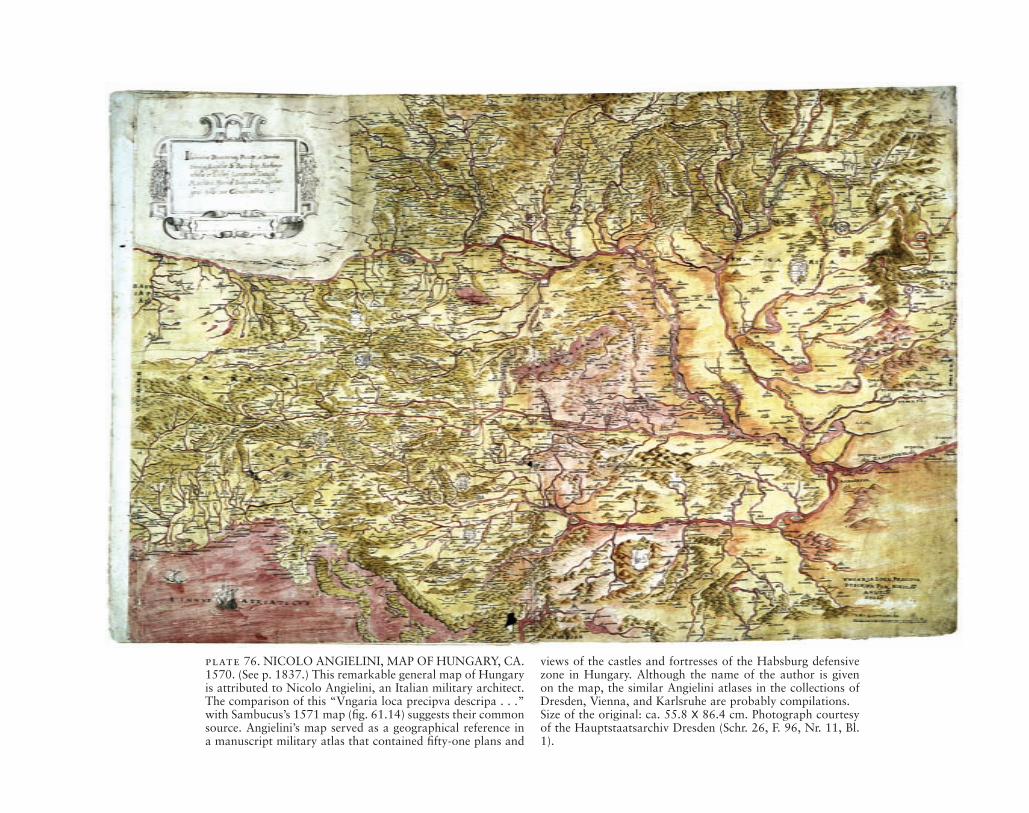
plate 76. NICOLO ANGIELINI, MAP OF HUNGARY, CA. 1570. (See p. 1837.) This remarkable general map of Hungary is attributed to Nicolo Angielini, an Italian military architect. The comparison of this “Vngaria loca precipva descripa . . .” with Sambucus’s 1571 map (fi g. 61.14) suggests their common source. Angielini’s map served as a geographical reference in a manuscript military atlas that contained fi fty-one plans and
views of the castles and fortresses of the Habsburg defensive zone in Hungary. Although the name of the author is given on the map, the similar Angielini atlases in the collections of Dresden, Vienna, and Karlsruhe are probably compilations.Size of the original: ca. 55.8 X 86.4 cm. Photograph courtesy of the Hauptstaatsarchiv Dresden (Schr. 26, F. 96, Nr. 11, Bl. 1).

plate 77. MARTIN STIER, MANUSCRIPT MAP OF THE STYRIAN FRONTIER, 1657. (See p. 1850.) The southeastern section of the Habsburg military defensive zone is represented. In the upper left is the capital of Styria, Grätz (Graz, Aus-tria). The river Mura fl ows in a southeastern direction toward Canischa (Nagykanizsa, Hungary). In the bottom left a section
of the river Trah (Drava) is shown. The decorative Baroque style cartouche in the upper right shows the legend, with fl ags expressing the military signifi cance of the map.Size of the original: ca. 37.1 X 50.3 cm. Photograph courtesy of the Bildarchiv, Österreichische Nationalbibliothek, Vienna(Handschriftensammlung, Cod. 8608, fol. 4).

plate 78. DETAIL FROM A NINETEENTH-CENTURY COPY OF A SEVENTEENTH-CENTURY MAP OF THE TOWN OF KASHIN AND ITS SURROUNDINGS. (See p. 1869.) The manuscript map follows common color conven-tions: blue for water; green for vegetation, yellowish-brown
for roads, and red for buildings.Size of the entire original: ca. 62 X 80 cm; size of the detail: ca. 31 X 42 cm. Rossiyskaya Gosudarstvennaya Biblioteka, Moscow. Photograph courtesy of Alexey Postnikov.

plate 79. SEMYON ULIANOVICH REMEZOV, MAP OF THE ISET RIVER. (See p. 1888.) Above the upper frame is the title: “Chapter 21. The Iset River drawn with urochishchafrom the mouth and to the upper reaches, the streams and lakes and with settlements.” In the lower right is a cartouche with
a list of standard abbreviations.Size of the original: 16.5 X 25.3 cm. From Remezov’s “Kho-rografi cheskaya chertëzhnaya kniga,” p. 30. By permission of Houghton Library, Harvard University.

plate 80. SEMYON ULIANOVICH REMEZOV, ETH-NOGRAPHIC MAP OF SIBERIA. (See p. 1900.) The title of the map is “Chertëzh i skhodsvo nalichie zemel’ vsey Sibiri, Tobol’skogo goroda i vsekh roznykh gradov i zhilich i stepi.” To compile this map Remezov used the map of 1673 as a basis, but he updated its geographic content. Among the featuresof the map should be noted the depiction of Kamchatka as a peninsula and not an island, as on Remezov’s other general
maps. All the inscriptions characterize not so much the ethno-graphic nomenclature of Siberia, largely rather archaic, as the interest of the author in studying the “native” boundaries of the Siberian peoples and tribes.Size of the original: 42.2 X 62.8 cm. From Remezov’s “Chertë-zhnaya kniga Sibiri,” sheets 47v–48. Photograph courtesy of Rossiyskaya Gosudarstvennaya Biblioteka, Moscow (Manu-script Division, stock 256, no. 346).