Embed Size (px)
Citation preview

C H A P T E R 8 • G L O B A L C L I M AT E S A N D C L I M AT E C H A N G E200
systems available to various scientists for the classification of cli-mates on a more local scale. The Köppen system, however, has been widely adopted by physical geographers and other scientists; in a modified version, it will be the basis for the worldwide re-gional study of present-day climates in Chapters 9 and 10.
The remainder of this chapter focuses on climate change. Climates in the past were not the same as they are today, and there is every reason to believe that future climates will be different as well. It is now widely recognized that humans may also alter Earth’s climate.
For decades scientists have realized that Earth has experienced major climate shifts during its history. It was believed that these shifts were gradual and could not be detected by humans during their lifetimes. However, recent research reveals that climate has shifted repeatedly between extremes over some exceedingly short intervals. Moreover, the research has revealed that climate during the most recent 10,000 years has been extraordinarily stable com-pared to similar intervals in the past.
To predict future climates, it is critical that we examine the details of past climate changes, including both the magnitude and rates of prehistoric climate change. Earth has experienced both ice ages and lengthy periods that were warmer than today. These fluctuations serve as indicators of the natural variability of climate in the absence of significant human impact. Using knowledge of present and past climates, as well as models of how and why cli-mate changes, we conclude this chapter with some predictions of future climate trends.
Classifying ClimatesKnowledge that climate varies from region to region dates to ancient times. The early Greeks (such as Aristotle, circa 350 BC) classified the known world into Torrid, Temperate, and Frigid zones based on their relative warmth. It was also recog-nized that these zones varied systematically with latitude and that the flora and fauna reflected these changes as well. With the further exploration of the world, naturalists noticed that the distribution of climates could be explained using factors such as sun angles, prevailing winds, elevation, and proximity to large water bodies.
The two weather variables used most often as indicators of climate are temperature and precipitation. To classify cli-mates accurately, climatologists require a minimum of 30 years of data to describe the climate of an area. The invention of an instrument to reliably measure temperature—the thermom-eter—dates only to Galileo in the early 17th century. Euro-pean settlement of and sporadic collection of temperature and precipitation data from distant colonies began in the 1700s but was not routine until the mid-19th century. This was soon fol-lowed in the early 20th century by some of the first attempts to classify global climates using actual temperature and pre-cipitation data.
As we have seen in earlier chapters, temperature and pre-cipitation vary greatly over Earth’s surface. Climatologists have worked to reduce the infinite number of worldwide variations
in atmospheric elements to a comprehensible number of groups by combining elements with similar statistics ( ● Fig. 8.1). That is, they can classify climates strictly on the basis of atmospheric ele-ments, ignoring the causes of those variations (such as the fre-quency of air mass movements). This type of classification, based on statistical and mathematical parameters or physical charac-teristics, is called an empirical classification. A classification based on the causes, or genesis, of climate variation is known as a genetic classification.
Ordering the vast wealth of available climatic data into de-scriptions of major climatic groups, on either an empirical or a genetic basis, enables geographers to concentrate on the larger-scale causes of climatic differentiation. In addition, they can ex-amine exceptions to the general relationships, the causes of which are often one or more of the other atmospheric controls. Finally, differentiating climates helps explain the distribution of other climate-related phenomena of importance to humans.
Despite its value, climate classification is not without its prob-lems. Climate is a generalization about observed facts and data based on the averages and probabilities of weather. It does not describe a real weather situation; instead, it presents a composite weather picture. Within such a generalization, it is impossible to include the many variations that actually exist. Thus, classification systems must sometimes be adjusted to changes in climate. On a global scale, generalizations, simplifications, and compromises are made to distinguish among climate types and regions.
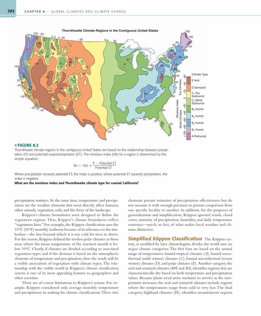
The Thornthwaite SystemOne system for classifying climates concentrates on a local scale. This system is especially useful for soil scientists, water resources specialists, and agriculturalists. For example, for a farmer interested in growing a specific crop in a particular area, a system classifying large regions of Earth is inadequate. Identifying the major vegeta-tion type of the region and the annual range of both tempera-ture and precipitation does not provide a farmer with informa-tion concerning the amounts and timing of annual soil moisture surpluses or deficits. From an agricultural perspective, it is much more important to know that moisture will be available in the growing season, whether it comes directly in the form of precipi-tation or from the soil.
Developed by an American climatologist, C. Warren Thorn-thwaite, the Thornthwaite system establishes moisture avail-ability at the subregional scale ( ● Fig. 8.2). It is the system pre-ferred by those examining climates on a local scale. Development of detailed climate classification systems such as the Thornthwaite system became possible only after temperature and precipitation data were widely collected at numerous locations beginning in the latter half of the 19th century.
The Thornthwaite system is based on the concept of potential evapotranspiration (potential ET), which approximates the water use of plants with an unlimited water supply. (Evapotrans-piration, discussed in Chapter 6, is a combination of evaporation and transpiration, or water loss through vegetation.) Potential ET is a theoretical value that increases with increasing temperature, winds, and length of daylight and decreases with increasing hu-
55061_08_Ch08_p198-229 pp3.indd 20055061_08_Ch08_p198-229 pp3.indd 200 6/5/08 11:50:48 PM6/5/08 11:50:48 PM

201
midity. In contrast, actual evapotranspiration (actual ET) reflects actual water use by plants. This water can be supplied dur-ing the dry season by soil moisture if the soil is saturated, the climate is relatively cool, and/or the day lengths are short. Thus, measurements of actual ET relative to potential ET and avail-able soil moisture are the determining factors for most vegetation and crop growth. Figure 6.8 shows a visual representation of the Thornthwaite system as it applies to the San Francisco, California area.
The Thornthwaite system recognizes three climate zones based on potential ET values: low-latitude climates, with potential ET greater than 130 centimeters (51 in.); middle-latitude climates, with potential ET less than 130 but greater than 52.5 centime-ters (20.5 in.); and high-latitude climates, with potential ET less than 52.5 centimeters. Climate zones may be subdivided based on how long and by how much actual ET is below potential ET. Moist climates have either a surplus or a minor deficit of less than 15 centimeters (6 in.). Dry climates have an annual deficit greater than 15 centimeters.
Thornthwaite’s original equations for potential ET were based on analyses of data collected in the midwestern and eastern United States. The method was subsequently used with less success in other parts of the world. Over the past few decades, many attempts have been made to improve the accuracy of the Thornthwaite system for regions outside the United States.
The Köppen SystemThe most widely used climate classification is based on regional temperature and precipitation patterns. It is referred to as the Köppen system after the German botanist and climatologist who developed it. Wladimir Köppen recognized that major veg-etation associations reflect the area’s climate. Hence, his climate regions were formulated to coincide with well-defined vegeta-tion regions, and each climate region was described by the natural vegetation most often found there. Evidence of the strong influ-ence of Köppen’s system is seen in the wide usage of his climatic terminology, even in nonscientific literature (for example, steppe climate, tundra climate, rainforest climate).
Advantages and Limitations of the Köppen System Not only are temperature and precipitation two of the easiest weather elements to measure, but they are also mea-sured more often and in more parts of the world than any other variables. By using temperature and precipitation statistics to define his boundaries, Köppen was able to develop precise defini-tions for each climate region, eliminating the imprecision that can develop in verbal and sometimes in genetic classifications.
Moreover, temperature and precipitation are the most impor-tant and effective weather elements. Variations caused by the atmo-spheric controls will show up most obviously in temperature and
C L A S S I F Y I N G C L I M AT E S
Hot desert
Hot semiarid
Mild, drysummer,
wet winter
Highlands
Mild, wetall year
Semiarid
Cool desert
Mild, moist
Mild winters,hot summers
30°
40°
50°
● FIGURE 8.1(a) This map shows the diversity of climates possible in a relatively small area, including portions of Chile, Argentina, Uruguay, and Brazil. The climates range from dry to wet and from hot to cold, with many possible combinations of temperature and moisture charac-teristics. (b) The Argentine Patagonian Steppe. (c) A meadow in the Argentine, Tierra del Fuego.What can you suggest as the causes for the major climate changes as you follow the 40°S latitude line from west to east across South America?
(a)
M. T
rapa
sso
M. T
rapa
sso
(c)
(b)
55061_08_Ch08_p198-229 pp3.indd 20155061_08_Ch08_p198-229 pp3.indd 201 6/5/08 11:50:49 PM6/5/08 11:50:49 PM
C H A P T E R 8 • G L O B A L C L I M AT E S A N D C L I M AT E C H A N G E202
precipitation statistics. At the same time, temperature and precipi-tation are the weather elements that most directly affect humans, other animals, vegetation, soils, and the form of the landscape.
Köppen’s climate boundaries were designed to define the vegetation regions. Thus, Köppen’s climate boundaries reflect “vegetation lines.” For example, the Köppen classification uses the 10°C (50°F) monthly isotherm because of its relevance to the tim-berline—the line beyond which it is too cold for trees to thrive. For this reason, Köppen defined the treeless polar climates as those areas where the mean temperature of the warmest month is be-low 10°C. Clearly, if climates are divided according to associated vegetation types and if the division is based on the atmospheric elements of temperature and precipitation, then the result will be a visible association of vegetation with climate types. The rela-tionship with the visible world in Köppen’s climate classification system is one of its most appealing features to geographers and other scientists.
There are of course limitations to Köppen’s system. For ex-ample, Köppen considered only average monthly temperature and precipitation in making his climate classifications. These two
elements permit estimates of precipitation effectiveness but do not measure it with enough precision to permit comparison from one specific locality to another. In addition, for the purposes of generalization and simplification, Köppen ignored winds, cloud cover, intensity of precipitation, humidity, and daily temperature extremes—much, in fact, of what makes local weather and cli-mate distinctive.
Simplified Köppen Classification The Köppen sys-tem, as modified by later climatologists, divides the world into six major climate categories. The first four are based on the annual range of temperatures: humid tropical climates (A), humid meso-thermal (mild winter) climates (C), humid microthermal (severe winter) climates (D), and polar climates (E). Another category, the arid and semiarid climates (BW and BS), identifies regions that are characteristically dry based on both temperature and precipitation values. Because plants need more moisture to survive as the tem-perature increases, the arid and semiarid climates include regions where the temperatures range from cold to very hot. The final category, highland climates (H ), identifies mountainous regions
Moi
stur
e In
dex
Thornthwaite Climate Regions in the Contiguous United States 100
100
10060
80
80
80
40
80
80
60
40
40
40
40
40
80
60
20
2020 20
4040
200
−20
−40
−40−20
−20
−20
20
20
100
100 100
0
0 0 0 −20−20
−40
20
20
0 −20
−20−40
−20
20−4020
−20
0−20 20
40
20
20
−40Climate Type
E Arid
D Semiarid
C1 DrySubhumid
C2 MoistSubhumid
B4 Humid
B3 Humid
B2 Humid
B1 Humid
A Perhumid
−60
−40
−20
0+
20+
40+
60+
80+
100
Dry
Clim
ates
Moi
st C
limat
es
−200−40
100
80
● FIGURE 8.2Thornthwaite climate regions in the contiguous United States are based on the relationship between precipi-tation (P) and potential evapotranspiration (ET). The moisture index (MI) for a region is determined by this simple equation:
MI 5 100 3 P 2 Potential ET
Potential ET
Where precipitation exceeds potential ET, the index is positive; where potential ET exceeds precipitation, the index is negative.What are the moisture index and Thornthwaite climate type for coastal California?
55061_08_Ch08_p198-229 pp3.indd 20255061_08_Ch08_p198-229 pp3.indd 202 6/5/08 11:50:52 PM6/5/08 11:50:52 PM

203C L A S S I F Y I N G C L I M AT E S
s stated at the beginning of this chapter, weather and climate are different ways of looking at how
our atmosphere affects various loca-tions on Earth. Weather deals with the state of the atmosphere at one point in time, or in the short term. It describes what is going on outside today or in the next few days. Climate deals with the conditions of the atmosphere in the long term, in other words, how the atmosphere behaves in a particular area through the months and years. Usually, a minimum record of 30 years is required to establish what an area’s climate might bring. Therefore a climate can be described as, but is not restricted to, a compilation of average values used to
summarize atmospheric conditions of an area.
It is possible to summarize the nature of the climate at any point on Earth in graph form, as shown in the accompany-ing figure. Given information on mean monthly temperature and rainfall, we can express the nature of the changes in these two elements throughout the year simply by plotting their values as points above or below (in the case of tempera-ture) a zero line. To make the pattern of the monthly temperature changes clearer, we can connect the monthly values with a continuous line, producing an annual temperature curve. Monthly precipitation amounts are usually shown as bars reaching to various heights above
the line of zero precipitation. Such a display of a location’s climate is called a climograph. To read the graph, one must relate the temperature curve to the values given along the left side and the precipitation amounts to the scale on the right. Other information may also be displayed, depending on the type of climograph used.
The climograph shown here represents the type that we use in Chapters 9 and 10. This climograph can be used to determine the Köppen classification of the station as well as to show its specific temperature and rainfall measures. The climate clas-sification abbreviations relating to all climo-graphs are found in Table 8.1.
A
Station: Nashville, Tenn.Latitude: 36°N
Type: Humid Subtropical (Cfa)Longitude: 88°W
Av. annual prec.: 119.6 cm (47.1 in.)Av. Annual temp.: 15.2°C (59.5°F)
°F °C In.Cm
J F M A M J J A S O N D
100
30 70
30
25
20
15
10
5
60
50
40
30
20
10
20
10
0
−10
−20
−30
−40
80
60
40
20
0
−20
−40
Range: 22.5°C (40.5°F)
A standard climograph showing average monthly temperature (curve) and rainfall (bars). The horizontal index lines at 0°C (32°F), 10°C (50°F), 18°C (64.4°F), and 22°C (71.6°F) are the Köppen temperature parameters by which the station is classified.
G E O G R A P H Y ’ S P H Y S I C A L S C I E N C E P E R S P E C T I V E
Using Climographs
55061_08_Ch08_p198-229 pp3.indd 20355061_08_Ch08_p198-229 pp3.indd 203 6/5/08 11:50:53 PM6/5/08 11:50:53 PM

C H A P T E R 8 • G L O B A L C L I M AT E S A N D C L I M AT E C H A N G E204
where vegetation and climate vary rapidly as a result of changes in elevation and exposure.
Within each of the first five major categories, individual climate types and subtypes are differentiated from one another by specific parameters of temperature and precipitation. Table 1 in the “Graph Interpretation” exercise, pages 226–229, outlines the letter designations and procedures for determining the types and subtypes of the Köppen classification system. This table can be used with any Köppen climate type presented in this chapter as well as Chapters 9 and 10.
The Distribution of Climate Types Five of the six major climate categories of the Köppen classification include enough differences in the ranges, total amounts, and seasonality of temperature and precipitation to produce the 13 distinctive cli-mate types listed in Table 8.1. The tropical and arid climate types are discussed in some detail in the next chapter; the mesothermal, microthermal, and polar climates are presented in Chapter 10, along with a brief coverage of undifferentiated highland climates.
Tropical (A) Climates Near the equator we find high temperatures year-round because the noon sun is never far from 90° (directly overhead). Humid climates of this type with no win-ter season are Köppen’s tropical climates. As his boundary for tropical climates, Köppen chose 18°C (64.4°F) for the average temperature of the coldest month because it closely coincides with the geographic limit of certain tropical palms.
Table 8.1 shows that there are three humid tropical climates, reflecting major differences in the amount and distribution of rainfall within the tropical regions. Tropical climates extend pole-ward to 30° latitude or higher in the continent’s interior but to lower latitudes near the coasts because of the moderating influ-ence of the oceans on coastal temperatures.
Regions near the equator are influenced by the intertropi-cal convergence zone (ITCZ). However, the convergent and rising air of the ITCZ, which brings rain to the tropics, is not an-chored in one place; instead, it follows the 90° sun angle (see again “The Analemma,” Chapter 3), migrating with the seasons. Within 5°–10° latitude of the equator, rainfall occurs year-round because the ITCZ moves through twice a year and is never far away ( ● Fig. 8.3). Poleward of this zone, the stabilizing influence of subtropical high pressure systems causes precipitation to become seasonal. When the ITCZ is over the region during the high-sun period (summer), there is adequate rainfall. However, during the low-sun period (winter), the subtropical highs and trade winds invade the area, bringing clear, dry weather.
We find the tropical rainforest climate (Af) in the equatorial region flanked both north and south by the dry-winter tropical savanna (Aw) climate ( ● Fig. 8.4). Finally, along coasts facing the strong, moisture-laden inflow of air associated with the summer monsoon, we find the tropical monsoon (Am) climate ( ● Fig. 8.5). Note the equatorial regions of Africa and South America shown in ● Figure 8.6. The atmospheric processes that produce the vari-ous tropical (A) climates are discussed in Chapter 9.
TABLE 8.1Simplified Köppen Climate Classes
Climates Climograph Abbreviation
Humid Tropical Climates (A)Tropical Rainforest Climate Tropical Rf.Tropical Monsoon Climate Tropical Mon.Tropical Savanna Climate Tropical Sav.
Arid Climates (B)Steppe Climate Low-lat./Mid-lat. SteppeDesert Climate Low-lat./Mid-lat. Desert
Humid Mesothermal (Mild Winter) Climates (C)Mediterranean Climate Medit.Humid Subtropical Climate Humid Subt.Marine West Coast Climate Marine W.C.
Humid Microthermal (Severe Winter) Climates (D)Humid Continental, Hot-Summer Climate Humid Cont. H.S.Humid Continental, Mild-Summer Climate Humid Cont. M.S.Subarctic Climate Subarctic
Polar Climates (E)Tundra Climate TundraIce-sheet Climate Ice-sheet
Highland Climates (H)Various climates based on elevation differences.
No single climograph can depict these varied (or various) climates
55061_08_Ch08_p198-229 pp3.indd 20455061_08_Ch08_p198-229 pp3.indd 204 6/5/08 11:50:54 PM6/5/08 11:50:54 PM

205
Polar (E) Climates Just as the tropical climates lack win-ters (cold periods), the polar climates—at least statistically—lack summers. Polar climates, as defined by Köppen, are areas in which no month has an average temperature exceeding 10°C (50°F). Poleward of this temperature boundary, trees cannot sur-vive. The 10°C isotherm for the warmest month more or less co-incides with the Arctic Circle, poleward of which the sun does not rise above the horizon in midwinter and though the length of day increases during polar summers, the insolation strikes at a low angle.
The polar climates are subdivided into tundra and ice-sheet climates. The ice-sheet (EF) climate ( ● Fig. 8.7) has no month with an average temperature above 0°C (32°F). The Tundra (ET) climate ( ● Fig. 8.8) occurs where at least 1 month averages above 0°C (32°F). Look at the far northern regions of Eurasia, North America, and Antarctica in Figure 8.6. The processes creating the polar (E) climates are explained in Chapter 10.
Mesothermal (C) and Microthermal (D) Climates Except where arid climates intervene, the lands between the tropical and polar climates are occupied by the tran-sitional middle-latitude mesothermal and microthermal climates. As they are neither tropical nor polar, the mild and severe win-ter climates must have at least 1 month averaging below 18°C (64.4°F) and 1 month averaging above 10°C (50°F). Although both middle-latitude climate categories have distinct temperature seasons, the microthermal climates have severe winters with at least 1 month averaging below freezing. Once again, vegeta-tion reflects the climatic differences. In the severe-winter climates, all broadleaf and even some species of needle-leaf trees defoli-ate naturally during the winter (generally, needle-leaf trees do not defoliate in winter) because soil water is temporarily frozen and unavailable. Much of the natural vegetation of the mild-winter mesothermal climates retains its foliage throughout the year because liquid water is always present in the soil. The line sepa-rating mild from severe winters usually lies in the vicinity of the 40th parallel.
A number of important internal differences within the me-sothermal and microthermal climate groups produce individual climate types based on precipitation patterns or seasonal tempera-ture contrasts. The Mediterranean, or dry summer, mesothermal (Csa, Csb) climate (like Southern California or southern Spain in Figure 8.6) appears along west coasts between 30° and 40° latitude ( ● Fig. 8.9). On the east coasts, in generally the same lati-tudes, the humid subtropical climate is found ( ● Fig. 8.10). This type of climate is found in regions like the southeastern United States and southeastern China in Figure 8.6.
The distinction between the humid subtropical (Cfa) and marine west coast (Cf b, Cf c) climates illustrates a second important criterion for the internal subdivisions of middle-latitude climates: seasonal contrasts. Both mesothermal climates have year-round pre-cipitation, but humid subtropical summer temperatures are much higher than those in the marine west coast climate. Therefore, summers are hot. In contrast, the mild summers of the marine west coast climate, located poleward of the Mediterranean climate along continental west coasts, often extend beyond 60° latitude
C L A S S I F Y I N G C L I M AT E S
● FIGURE 8.3Tropical rainforest climate: island of Jamaica.
R. G
able
r
● FIGURE 8.4Tropical savanna climate: East African high plains.
R. G
able
r
● FIGURE 8.5Tropical monsoon climate: Himalayan foothills, West Bengal, India.
R. G
able
r
55061_08_Ch08_p198-229 pp3.indd 20555061_08_Ch08_p198-229 pp3.indd 205 6/5/08 11:50:54 PM6/5/08 11:50:54 PM

C H A P T E R 8 • G L O B A L C L I M AT E S A N D C L I M AT E C H A N G E206
● FIGURE 8.6World map of climates in the modified Köppen classification system.
55061_08_Ch08_p198-229 pp3.indd 20655061_08_Ch08_p198-229 pp3.indd 206 6/5/08 11:50:58 PM6/5/08 11:50:58 PM

207C L A S S I F Y I N G C L I M AT E S
A Western Paragraphic Projection developed at Western Illinois University
55061_08_Ch08_p198-229 pp3.indd 20755061_08_Ch08_p198-229 pp3.indd 207 6/11/08 12:51:31 PM6/11/08 12:51:31 PM

C H A P T E R 8 • G L O B A L C L I M AT E S A N D C L I M AT E C H A N G E208
● FIGURE 8.7Polar ice-sheet climate: glaciers near the southern coast of Greenland.
J. P
eter
sen
● FIGURE 8.8Tundra climate: caribou in the Alaskan tundra during the summer.
Alas
ka Im
age
Libr
ary/
USFW
S
● FIGURE 8.9Mediterranean mesothermal climate: village in southern Spain.
R. G
able
r
● FIGURE 8.10Humid subtropical climate: grapefruit grove in central Florida.
R. G
able
r
( ● Fig. 8.11). Some examples of marine west coast climates, shown in Figure 8.6, are along the northwest coast of the United States and extending into Canada, the west coast of Europe, and the Brit-ish Isles.
Another example of internal differences is found among microthermal (D) climates, which usually receive year-round precipitation associated with middle-latitude cyclones traveling along the polar front. Internal subdivision into climate types is based on summers that become shorter and cooler and winters that become longer and more severe with increasing latitude and continentality. Microthermal climates are found exclusively in the Northern Hemisphere ( ● Fig. 8.12) because there is no land in the Southern Hemisphere latitudes that would normally be occupied by these climate types. In the Northern Hemisphere, these climates progress poleward through the humid continental, hot-summer (Dfa, Dwa) climate, to the humid continental, mild- summer (Dfb, Dwb) climate, and finally, to the subarctic (Dfc, Dfd, Dwc, and Dwd) climate ( ● Fig. 8.13). Microclimate regions can be seen in the eastern United States and Canada or northward through eastern Europe in Figure 8.6.
Arid (B) Climates Climates that are dominated by year-round moisture deficiency are called arid climates. These cli-mates will penetrate deep into the continent, interrupting the latitudinal zonation of climates that would otherwise exist. The definition of climatic aridity is that precipitation received is less than potential ET. Aridity does not depend solely on the amount of precipitation received; potential ET rates and tem-perature must also be taken into account. In a low-latitude cli-mate with relatively high temperatures, the potential ET rate is greater than in a colder, higher-latitude climate. As a result, more rain must fall in the lower latitudes to produce the same effects (on vegetation) that smaller amounts of precipitation produce in areas with lower temperatures and, consequently, lower potential ET rates. Potential ET rates also decrease with altitude, which helps to explain why higher altitude (highland) climates are dis-tinguished separately.
55061_08_Ch08_p198-229 pp3.indd 20855061_08_Ch08_p198-229 pp3.indd 208 6/5/08 11:50:58 PM6/5/08 11:50:58 PM

209
● FIGURE 8.11Marine west coast climate: North Sea coast of Scotland.
R. G
able
r
● FIGURE 8.12Microthermal, severe winter climate: winter in Illinois.
R. G
able
r
C L A S S I F Y I N G C L I M AT E S
● FIGURE 8.13Microthermal, subarctic climate: these trees endure a long winter in Alaska.
Alas
ka Im
age
Libr
ary/
USFW
SArid climates are concentrated in a zone from about 15°N
and S to about 30°N and S latitude along the western coasts, ex-panding much farther poleward over the heart of each landmass. The correspondence between the arid climates and the belt of subtropical high pressure systems is quite unmistakable (like in the southwestern United States, central Australia, and north Africa in Fig. 8.6), and the poleward expansion is a consequence of re-moteness from the oceanic moisture supply.
In desert (BW ) climates, the annual amount of precipitation is less than half the annual potential ET ( ● Fig. 8.14). Bordering the deserts are steppe (BS) climates—semiarid climates that are transitional between the extreme aridity of the deserts and the moisture surplus of the humid climates ( ● Fig. 8.15). The defi-nition of the steppe climate is an area where annual precipita-tion is less than potential ET but more than half the potential ET. B climates and the processes that create them are discussed in more detail in Chapter 9.
● FIGURE 8.14Desert climate: Sonoran Desert of Arizona.
R. G
able
r
● FIGURE 8.15Steppe climate: Sand Hills of Nebraska.
R. G
able
r
55061_08_Ch08_p198-229 pp3.indd 20955061_08_Ch08_p198-229 pp3.indd 209 6/5/08 11:51:05 PM6/5/08 11:51:05 PM

C H A P T E R 8 • G L O B A L C L I M AT E S A N D C L I M AT E C H A N G E210
● FIGURE 8.16Highland climate: Uncompahare National Forest, Colorado.
Nat
ural
Res
ourc
es C
onse
rvat
ion
Serv
ice/
Gene
Ale
xand
er
Highland (H) Climates The pattern of climates and ex-tent of aridity are affected by irregularities in Earth’s surface, such as the presence of deep gulfs, interior seas, or significant highlands. The climatic patterns of Europe and North America are quite different because of such variations.
Highlands can channel air mass movements and create abrupt climatic divides. Their own microclimates form an intricate pat-tern related to elevation, cloud cover, and exposure ( ● Fig. 8.16). One significant effect of highlands aligned at right angles to the prevailing wind direction is the creation of arid regions extend-ing tens to hundreds of kilometers leeward. Look at the moun-tain ranges in Figure 8.6: the Rockies, the Andes, the Alps, and the Himalayas show H climates. These undifferentiated highland climates are discussed in more detail in Chapter 10.
Climate RegionsEach of our modified Köppen climate types is defined by specific parameters for monthly averages of temperature and precipitation; thus, it is possible to draw boundaries between these types on a world map. The areas within these boundaries are examples of one type of world region. The term region, as used by geographers, refers to an area that has recognizably similar internal characteris-tics that are distinct from those of other areas. A region may be de-scribed on any basis that unifies it and differentiates it from others.
As we examine the climate regions of the world in the chap-ters that follow, you should make frequent reference to the map of world climate regions (see again Fig. 8.6). It shows the patterns of Earth’s climates as they are distributed over each continent. However, a word of caution is in order. On a map of climate re-gions, distinct lines separate one region from another. Obviously, the lines do not mark points where there are abrupt changes in temperature or precipitation conditions. Rather, the lines signify zones of transition between different climate regions. Further-more, these zones or boundaries between regions are based on monthly and annual averages and may shift as temperature and moisture statistics change over the years.
The actual transition from one climate region to another is gradual, except in cases in which the change is brought about by an unusual climate control such as a mountain barrier. It would be more accurate to depict climate regions and their zones of transition on a map by showing one color fading into another. Always keep in mind, as we describe Earth’s climates, that it is the core areas of the regions that best exhibit the characteristics that distinguish one climate from another.
Now, let’s look more closely at Figure 8.6. One thing that is immediately noticeable is the change in climate with latitude. This is especially apparent in North America when we examine the East Coast of the United States moving north into Canada. Here the sun angles and length of day play an important role. We can also see that similar climates usually appear in similar latitudes and/or in similar locations with respect to landmasses, ocean cur-rents, or topography. These climate patterns emphasize the close relationship among climate, the weather elements, and the climate controls. These elements and controls are more fully correlated with their corresponding climates in Chapters 9 and 10. There is an order to Earth’s atmospheric conditions and so also to its climate regions.
A striking variation in these global climate patterns becomes apparent when we compare the Northern and Southern Hemi-spheres. The Southern Hemisphere lacks the large landmasses of the Northern Hemisphere; thus, no climates in the higher lati-tudes (in land regions) can be classified as humid microthermal, and only one small peninsula of Antarctica can be said to have a tundra climate.
Scale and ClimateClimate can be measured at different scales (macro, meso, or mi-cro). The climate of a large (macro) region, such as the Sahara, may be described correctly as hot and dry. Climate can also be described at mesoscale levels; for example, the climate of coastal Southern California is sunny and warm, with dry summers and wet winters. Finally, climate can be described at local scales, such as on the slopes of a single hill. This is termed a microclimate.
At the microclimate level, many factors will cause the climate to differ from nearby areas. For example, in the United States and other regions north of the Tropic of Cancer, south-facing slopes tend to be warmer and drier than north-facing slopes because they receive more sunlight ( ● Fig. 8.17). This variable is referred to as slope aspect—the direction a mountain slope faces in respect to the sun’s rays. Microclimatic differences such as slope aspect can cause significant differences in vegetation and soil moisture. In what is sometimes called topoclimates, tall mountains often pos-sess vertical zones of vegetation that reflect changes in the mi-croclimates as one ascends from the base of the mountain (which may be surrounded by a tropical-type vegetation) to higher slopes with middle latitude–type vegetation to the summit covered with ice and snow.
Human activities can influence microclimates as well. Re-cent research indicates that the construction of a large reservoir leads to greater annual precipitation immediately downwind of this impounded water. This occurs because the lake supplies addi-
55061_08_Ch08_p198-229 pp3.indd 21055061_08_Ch08_p198-229 pp3.indd 210 6/5/08 11:51:12 PM6/5/08 11:51:12 PM