Embed Size (px)
Citation preview

55: Estimation of Snow Extent and SnowProperties
DOROTHY K HALL1, RICHARD EJ KELLY2, JAMES L FOSTER1 AND
ALFRED TC CHANG1†
1NASA/Goddard Space Flight Center, Greenbelt, MD, US2University of Maryland, Baltimore, MD, US†Deceased May 26, 2004
Important advances have been made in the measurement of seasonal snow cover since the advent of satelliteremote sensing in the mid 1960s. Data from the visible, near-infrared, infrared, and microwave portions ofthe electromagnetic spectrum have proven useful for measuring different properties of snow. In terms of snowmapping, sensors employing visible and near-infrared wavelengths are now capable of accurately and reliablymeasuring snow-cover extent with a spatial resolution of up to 250 m on a daily basis, and even higherresolution for less-frequent coverage. Passive-microwave data, available since the 1970s, have been utilizedfor measuring snow extent, depth and snow-water equivalent (SWE), though at a coarse spatial resolutioncompared to visible data, while active-microwave sensors such as scatterometers, provide valuable informationon snowpack ripening. Capabilities of synthetic-aperture radar (SAR) data for snow-cover studies are still beingexplored, however, bands on current satellite SAR sensors are not ideal for measuring snow cover. Remotesensing data of snow cover are now well suited for use in hydrologic and general-circulation models. Inclusion ofremotely-sensed data significantly enhances our understanding of the Earth’s weather and climate, and decadal-scale climate change. Future improvements include refinement of snow-cover extent measurements, minimizingSWE errors, and improving our ability to ingest remote sensing data of snow into models.
INTRODUCTION
Satellite remote-sensing technology has virtually revolu-tionized the study of snow cover. The high albedo ofsnow presents a good contrast with most other naturalsurfaces (except clouds), and therefore is easily detectedby many satellite sensors. Weekly snow mapping of theNorthern Hemisphere using National Oceanographic andAtmospheric Administration (NOAA) satellite data beganin 1966 and continues today in the United States, but withimproved resolution and on a daily basis (Matson et al.,1986; Ramsay, 1998; Carroll et al., 2001). In addition,using Earth Observing System (EOS) Moderate Resolu-tion Imaging Spectroradiometer (MODIS) data, beginningin early 2000, global snow cover has been mapped on adaily basis at a spatial resolution of up to 500 m (Hallet al., 2002a).
In addition to the visible/near-infrared data, from MODISand NOAA satellite sensors, both passive and activemicrowave data have been useful for mapping snow anddetermining snow wetness and snow water equivalent(SWE) (Ulaby and Stiles, 1980) since the early 1970s.Using passive microwave data, snow extent, and SWEmay be estimated globally on a daily basis since thelaunch of the Nimbus-7 Scanning Multichannel MicrowaveRadiometer (SMMR) (Chang et al., 1987), and continuingwith the May 2002 launch of the Advanced MicrowaveScanning Radiometer (AMSR) (Kelly et al., 2003). Active-microwave sensors, such as from the NASA scatterometer(NSCAT), are especially useful for detecting snowpackripening (Nghiem and Tsai, 2001).
The geographical extent of snow cover over the NorthernHemisphere varies from a maximum of ∼46 × 106 km2 inJanuary and February to a minimum of ∼4 × 10⁶ km2 in
Encyclopedia of Hydrological Sciences. Edited by M G Anderson, 2005.This is a US Government work and is in the public domain in the United States of America.
812 REMOTE SENSING
August; between 60 and 65% of winter snow cover isfound over Eurasia, and most midsummer snow cover isin Greenland (Frei and Robinson, 1999). Numerous studieshave shown the importance of accurate measurements ofsnow and ice parameters as they relate to the Earth’s climateand climate change (for example, see Martinelli, 1979;Dewey and Heim, 1981 and 1983; Barry, 1983, 1984, and1990; Dozier, 1987; Ledley et al., 1999; Foster et al., 1987and 1996; Serreze et al., 2000; Dozier and Painter, 2004).Measurements have become increasingly sophisticated overtime. In addition, as the length of the satellite recordincreases, it becomes easier to determine trends that haveclimatic importance.
Three of the most important properties of a snow coverare depth, density, and water equivalent (Pomeroy andGray, 1995). If the snow depth and density are known,then the SWE may be calculated. SWE is a hydrologicallyimportant parameter as it determines the amount of waterthat will be available as snowmelt.
After introducing snow as a medium, and reviewingits optical and microwave properties, we will show howremote sensing is used to study snow-covered area, SWE,snow wetness and snow albedo, and discuss the param-eterization of snow in hydrologic and general circulationmodels (GCMs).
INTRODUCTION TO SNOW CRYSTALS ANDDEVELOPMENT OF A SNOWPACK
Snow is a porous, permeable aggregate of ice grains (Bader,1962). Snow crystals nucleate and begin their growth inclouds where the temperature is below 0 ◦C. Snow crystalscan occur in a variety of relatively flat hexagonal or six-sided shapes (Figure 1), however, they can also occuras elongated columns and needles. Differences in snowcrystals are a result of variations in the temperature andhumidity of the atmosphere at the time of their formationand the action of the wind during their descent to the ground(Male, 1980). As a result, there is a myriad of possibleshapes that can form depending primarily on the cloudtemperature at the time the water vapor freezes.
Freshly fallen snow almost immediately begins to com-pact and metamorphose, initially preserving the originalshape of the snow crystal. The constant jostling and rub-bing of crystals against each other causes protuberances tobecome chipped and broken. As the snow settles under itsown weight, melts and refreezes, and is buffeted by thewind, individual crystals are further altered such that aftera few days they have little resemblance to their originalshape. A seasonal snowpack might have grain radii rangingfrom 0.1 to 0.5 mm throughout the season.
In the absence of a temperature gradient in the snow-pack, snowflakes undergo “destructive metamorphism” andbecome more rounded over time, with typically slower
Figure 1 This image of a newly fallen hexagonal platesnow crystal was taken with an Electron ScanningMicroscope and shows a classic dendritic snow crystal,having a central hexagonal plate, but lacking sharp edges.Because of the air temperature at the time of collection(close to 0 ◦C), this crystal may have undergone somesublimation (Wergin et al., 1996)
growth rates being more characteristic of the more-roundedcrystals. “Constructive metamorphism,” when large grainsgrow at the expense of small grains, occurs when thereis a thermal and vapor gradient in the snowpack and snowgrains at the base of the pack grow at the expense of smallergrains, hence the crystals develop distinctive shapes (Col-beck, 1982). Faster growth rates give rise to the facetedcrystals. Dry snow will metamorphose into large depth-hoar grains when subjected to a strong temperature gradient,and grain growth and dry-snow metamorphism control themovement and redistribution of mass, chemical species,and isotopes in the snowpack (Sturm and Benson, 1997).Depth-hoar crystals may grow to 1 cm in size (Trabant andBenson, 1972).
Seasonal snowpacks develop from a series of winterstorms and are often created by various forms of pre-cipitation such as rain and freezing rain. Diurnal melt-ing and refreezing, and wind action are also importantin the ultimate development of a snowpack. Thus, sea-sonal snow cover usually develops a layered structure inwhich ice layers alternate with layers of a coarser texture(Male, 1980).
FUNDAMENTALS OF THE REMOTE SENSINGOF SNOW
Introduction With optical remote sensing, there is apotential to determine the extent and albedo of a snowcover, and some inference as to snow depth can be madebased on the ability of a snow cover to cover existing veg-etation of known height. Infrared sensors can provide snow
ESTIMATION OF SNOW EXTENT AND SNOW PROPERTIES 813
surface temperature, which may be a useful parameter forhydrologic modeling. Microwave measurements have thecapability to respond to the bulk properties of a snowpackas well as to variations in other surface and subsurfacefeatures because microwaves can penetrate the snowpackand thus provide information on snow depth and SWEwhen the snowpack is dry. Additionally, the microwave partof the spectrum allows remote observation of snow coverunder nearly all weather and lighting conditions. SWE isof critical importance for water resources and hydrologicand GCM modeling. In short, use of optical, infrared, andmicrowave sensors provides synergy that allows extractionof important snowpack properties for use in models.
Optical Properties The spectral albedo of a surfaceis the upflux divided by the downflux at a particularwavelength (Warren, 1982). The spectral albedo of freshsnow in the visible region of the spectrum remains highbut decreases slowly as snow ages, but in the near-infrared,the spectral albedo of aging snow decreases considerably ascompared to fresh snow (O’Brien and Munis, 1975; Warrenand Wiscombe, 1980; Wiscombe and Warren, 1980).
The broadband albedo is the reflectance across thereflective part of the solar spectrum. Broadband albedodecreases when grain size increases as the snow ages(Choudhury and Chang, 1979), and melting causes snowgrains to grow and bond into clusters (Dozier et al.,1981; Grenfell et al., 1981; Warren, 1982). Snow albedomay decrease by >25% within just a few days as grain
growth proceeds (Nolin and Liang, 2000). For example,Gerland et al. (1999) measured a maximum albedo >90%on Svalbard, Norway, before melt onset, and ∼60% aftermelt had progressed in the spring when the snow wasconsidered old, but still clean. The albedo of a snow coveris also influenced by the albedo of the land cover that itoverlies, especially when the snowpack is thin.
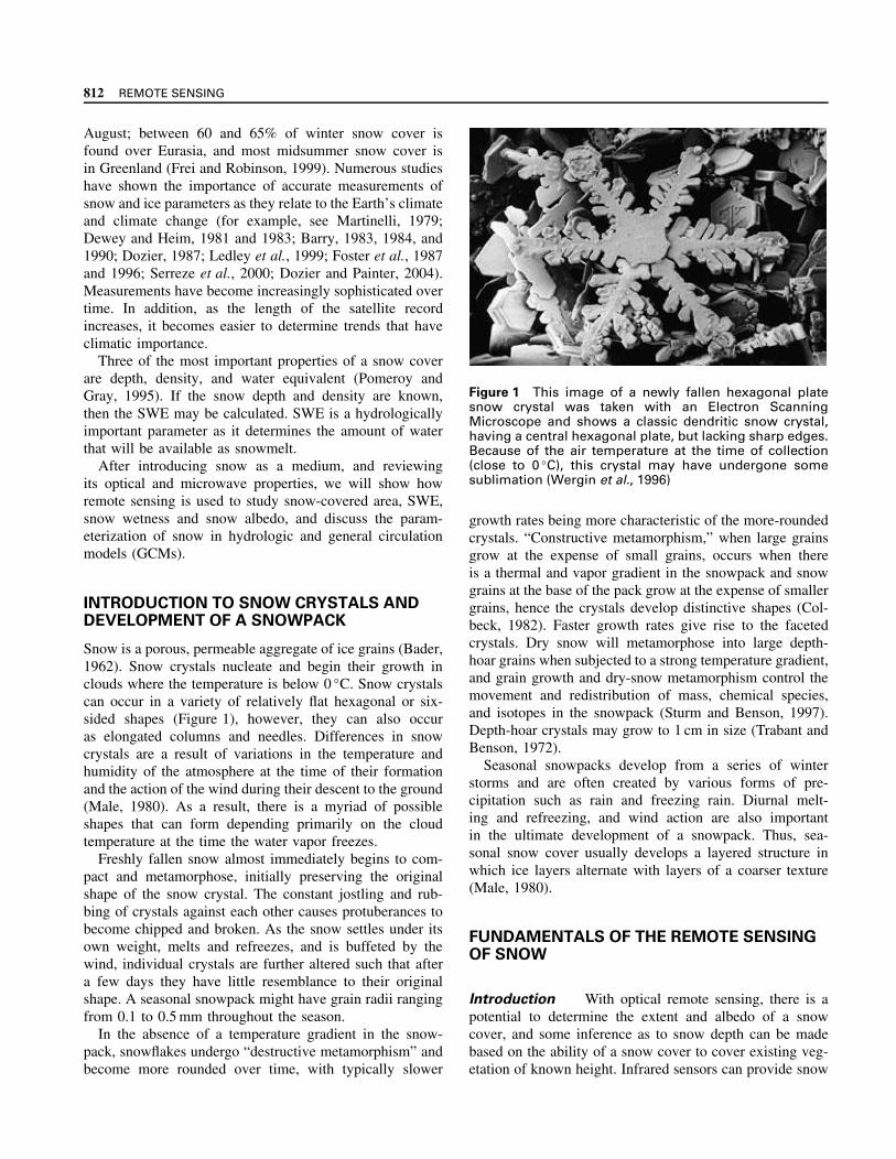
Grain size may be estimated using remotely sensed data(Dozier, 1984; Nolin and Dozier, 1993). With the onsetof surface melting and associated grain size increase, thenear-infrared reflectance decreases dramatically (Warren,1982) (Figure 2). The near-infrared albedo of snow is verysensitive to snow-grain size while visible albedo is lesssensitive to grain size, but is affected by snow impurities.Modeling by Warren and Wiscombe (1980) demonstratesthat small but highly absorbing particles can lower thesnow albedo in the visible part of the spectrum by 5–15%compared to pure snow. Hansen and Nazarenko (2004)report that anthropogenic soot emissions have reduced snowand ice albedos by 3% in Northern Hemisphere land areasto yield a climate forcing of +0.3 W m−2 in the NorthernHemisphere, thus contributing to global warming.
Though the reflectance of freshly fallen snow is nearlyisotropic (Dirmhirn and Eaton, 1975), as snow ages,the specular reflection component increases, especially inthe forward direction and with solar zenith angle (SZA)(Salomonson and Marlatt, 1968), and the anisotropic natureof snow reflectance increases with increasing grain size
r = 0.075 mm
r = 0.2 mm
r = 0.5 mm
0.35 0.55 0.75 0.95 1.15 1.35 1.55 1.75 1.95 2.15 2.35
Wavelength (µm)
1.0
0.9
0.8
0.7
0.6
0.5
0.4
0.3
0.2
0.1
0.0
Ref
lect
ance
Figure 2 Illustration of the effect of different snow crystals on snow reflectance (From Choudhury and Chang, 1979)

814 REMOTE SENSING
(Steffen, 1987). Effective snow-grain radii typically rangein size from ∼50 µm for new snow, to 1 mm for wet snowconsisting of clusters of ice grains (Warren, 1982).
Snow albedo increases at all wavelengths with the SZA.Additionally, cloud cover normally causes an increase inspectrally integrated snow albedo due to multiple reflec-tions caused by clouds (Grenfell and Maykut, 1977; War-ren, 1982).
Microwave Properties In the microwave part of thespectrum (300 to 1 GHz, or 1 mm to 30 cm wavelength),remote sensing can be accomplished either by measuringemitted radiation with a radiometer or by measuring theintensity of the return (in decibels) of a signal sent by aradar.
Microwave emission from a layer of snow over a groundsurface consists of contributions from the snow itself andfrom the underlying ground. Both contributions are gov-erned by the transmission and reflection properties of theair-snow and snow-ground interfaces, and by the absorp-tion/emission and scattering properties of the snow layer.
The dielectric properties of snow at a given microwavefrequency are generally dependent on the relative propor-tion of liquid and solid water in the snow by volume. Evenat temperatures <0 ◦C, liquid-like water exists in thin filmssurrounding, and bound to, ice crystals (Hobbs, 1974), butis considered to be dry since it contains no “free” liquidwater (Leconte et al., 1990). However, snow that containsa large amount of liquid water (>5% by volume) has a highdielectric constant (>35 below 20 GHz) relative to that ofdry snow.
Theoretically, the dielectric constant of snow consists ofthe sum of a real and an imaginary part. Snow is a mixtureof air and ice, the dielectric constant of air being 1.0 andice 3.17 ± 0.07 for frequencies from 1 MHz to well abovethe microwave region (Evans, 1965). Snow has a dielectricconstant between l.2 and 2.0 when the snow densities rangefrom 0.1 to 0.5 g cm−3 (Hallikainen and Ulaby, 1986).
If a dry snowpack contains ice and snow layers, specularreflection at the interfaces between layers may occurresulting in strongly enhanced backscatter in the case ofactive-microwave remote sensing (Matzler and Schanda,1984). Or, if the grain sizes of a dry snowpack are largeenough relative to the microwave wavelength, volumescattering will occur. Otherwise, the signal is returnedmainly from the ground/snow interface.
Longer wavelengths, in general, travel almost unaffectedthrough dry snow. X-band (2.4–3.75 cm, 8.0–12.5 GHz) orlower frequencies (longer wavelengths) are not generallyuseful for detecting and mapping thin, dry snow becausethe size of snow particles is much smaller than the size ofthe wavelength. Thus, at these longer wavelengths, there islittle chance for a microwave signal to be attenuated andscattered by the relatively small ice crystals comprisinga snowpack (Waite and MacDonald, 1970; Ulaby and
Stiles, 1980, 1981). Wavelengths longer than ∼10–15 cmare not impeded as they move through most dry seasonalsnowpacks (Bernier, 1987).
For snow crystals of a radius >∼0.1 mm, scatteringdominates emission at higher (>15 GHz) microwave fre-quencies (Ulaby et al., 1986). Absorption is determinedprimarily by the imaginary part of the refractive index. Indry snow, the imaginary part is very small, several orders ofmagnitude smaller than for water (Ulaby and Stiles, 1980).
The backscatter received by a synthetic-aperture radar(SAR) antenna is the sum of surface scattering at theair/snow interface, volume scattering within the snowpack,scattering at the snow/soil interface, and volumetric scat-tering from the underlying surface (if applicable). Mosttechniques developed for mapping snow cover using SARdata show promise for mapping only wet snow (see, forexample, Rott and Nagler, 1993; Shi et al., 1994). Thisis because it is difficult to distinguish dry snow from bareground using SAR data at the X-band and lower frequenciesthat are currently flown in space. Volume scattering from ashallow, dry snow cover (SWE <20 cm) is undetectableat C-band (5.3 GHz, 5.6 cm), for example, because thebackscatter is dominated by soil/snow scattering. Volume-scattering in dry snow results from scattering at dielectricdiscontinuities created by the differences in electrical prop-erties of ice crystals and air, and by ice lenses and layers.Atmospheric scattering is usually very small and can beneglected (Ulaby and Stiles, 1980; Leconte et al., 1990;Leconte, 1995).
In the case of wet snow (Stiles and Ulaby, 1980; Ulabyand Stiles, 1980; Rott, 1984; Ulaby et al., 1986), when atleast one layer of the snowpack (within the penetrationdepth of the radar signal) becomes wet (4–5% liquid watercontent), the penetration depth of the radar signal is reducedto about 3–4 cm (or one wavelength at X-band) (Matzlerand Schanda, 1984). Thus, there may be high contrastbetween snow-free ground and ground covered with wetsnow, thus making it possible to distinguish wet and dryland or snow when imaged with C-band SAR from space.
Volume scattering increases with snow-grain size andinternal layering, and with amount of snow. Radiation atwavelengths comparable in size to the snow crystal size(about 0.05–3.0 mm, or greater if depth hoar is present) isscattered in a dry snowpack according to Mie scatteringtheory. (Mie scattering predominates when the particlescausing the scattering are larger than the wavelengths ofradiation in contact with them.) Currently, only passivemicrowave sensors operate at these wavelengths fromsatellites.
In the microwave part of the spectrum, the radiationemitted from a perfect emitter is proportional to its physicaltemperature, T . However, most real objects emit only afraction of the radiation that a perfect emitter would emitat its physical temperature. The equivalent temperature of

ESTIMATION OF SNOW EXTENT AND SNOW PROPERTIES 815
the microwave radiation thermally emitted by an object iscalled its brightness temperature, TB , expressed in Kelvins.This fraction defines the emissivity, E, of an object (Changet al., 1976). In the microwave region,
E = TB
T(1)
Microwave emission from a layer of snow over a groundmedium consists of two contributions: (i) emission by thesnow volume and (ii) emission by the underlying ground.Both contributions are governed by the transmission andreflection properties of the air-snow and snow-ground inter-faces, and by the absorption/emission and scattering prop-erties of the snow layer (Stiles et al., 1981), and a myriadof physical parameters that affects the emission (Derksenet al., 2002). As an electromagnetic wave emitted fromthe underlying surface propagates through a snowpack, itis scattered by the randomly spaced snow particles in alldirections. As the snowpack grows deeper, there is moreloss of radiation due to scattering, and the emission of thesnowpack is reduced, thus lowering the TB . The deeperthe snow, the more crystals are available to scatter theupwelling microwave energy, and, thus, it is possible toestimate the depth and water equivalent of the snow usingpassive-microwave remote sensing.
Snow grains scatter the electromagnetic radiation inco-herently and are assumed to be spherical and randomlyspaced within the snowpack. Although most snow parti-cles are generally not spherical in shape, using Mie theory,their optical properties can be simulated as spheres (Changet al., 1976). We will discuss the scattering power of a vari-ety of different snow crystal shapes and their effect on themicrowave emission of a snowpack in a later section.
A wet snowpack radiates like a blackbody at the physicaltemperature of the snow layer, and is therefore indistin-guishable from snow-free soil using microwave remotesensing (Kunzi et al., 1982). The dielectric constants ofwater, ice, and snow are different enough so that even alittle surface melting causes a strong microwave response(Schanda et al., 1983; Foster et al., 1987). The scatteringloss decreases drastically with increasing liquid water con-tent (free water) and becomes negligible for values aboveabout 1% (Hallikainen, 1984).
SNOW MAPPING
Early attempts to forecast runoff from the areal extent ofsnow cover used terrestrial photographs (Potts, 1937). Otherobservations from aircraft were also undertaken such aslocating and mapping snow-cover extent and mapping thelocation of the snowline. Along with volume, the arealextent of snow cover has been used to predict snowmeltrunoff and to forecast floods.
Because of its high albedo, snow was easily observedin the first image obtained from the Television InfraredOperational Satellite-1 (TIROS-1) weather satellite in 1960.Data from meteorological satellites and manned spacecraftwere useful in determining snowline elevation, delineatingsnow boundaries, and observing changes in snow condi-tions due to rising temperatures and rain-on-snow events(Singer and Popham, 1963), and later, seasonal streamflowcould also be estimated (Rango and Salomonson, 1977).Data from Environmental Science Services Administration(ESSA) operational satellites were used as early as the mid-to-late 1960s to determine areal extent of snow cover.
A major step forward in snow mapping came with theadvent of the Landsat series of sensors beginning in 1972.Landsat-1 carried a Multispectral Scanner (MSS) sensorwith 80-m spatial resolution. With Landsat data came theability to create detailed basin-scale snow-cover maps ona regular basis when cloudcover permitted. At first, therepeat-pass interval for the Landsat satellite was 18 days,but this was decreased to 16 days with the launch ofLandsat-4 in 1982. Landsats-4 and -5 carried a ThematicMapper (TM) sensor with 30- m resolution, and Landsat-7carries an Enhanced Thematic Mapper Plus (ETM+) withspatial resolution of 30 m, except in the panchromatic bandwhere the resolution is 15 m. As of this writing, the TMonboard the Landsat-5 satellite is still operating. (Landsat-6 was lost after it failed to reach orbit in 1993.) Thoughthe Landsat series has provided high-quality, scene-basedsnow maps, the 16- or 18- day repeat-pass interval of theLandsat satellites is not adequate for most snow-mappingrequirements, especially during spring snowmelt.
Operational Snow-cover Mapping in the United
States The NOAA National Environmental Satellite,Data, and Information Service (NESDIS) began to gen-erate Northern Hemisphere Weekly Snow and Ice Coveranalysis charts derived from NOAA’s Geostationary Oper-ational Environmental Satellite (GOES) and Polar OrbitingEnvironmental Satellite (POES) visible satellite imagers inNovember 1966. Maps were manually constructed, and thespatial resolution of the charts was 190 km. Since 1997,the Interactive Multi-sensor Snow and Ice Mapping Sys-tem (IMS) has been used by analysts to produce productsdaily at a spatial resolution of about 25 km, and utilizesa variety of satellite data to generate the maps (Ramsay,1998). This snow-cover record has been studied carefully(Robinson et al., 1993; Robinson, 1997, 1999) and has beenreconstructed following adjustment for inconsistencies thatwere discovered in the early part of the data set (Robin-son and Frei, 2000; Frei et al., 1999). Results show thatthe Northern Hemisphere annual snow-covered area hasdecreased (Robinson et al., 1993; Brown and Goodison,1996; Hughes and Robinson, 1996; Hughes et al., 1996;Armstrong and Brodzik, 1998, 2001; Frei et al., 1999;

816 REMOTE SENSING
Brown, 2000); satellite data show a decrease of about 0.2%per year from 1979–1999 (Armstrong and Brodzik, 2001).
The National Operational Hydrologic Remote Sens-ing Center (NOHRSC) snow-cover maps, generated byNational Weather Service NOHRSC hydrologists, are dis-tributed electronically in near real time to local, state,and federal users during the snow season (Carroll, 1987and 1995; Cline et al., 1998; Carroll et al., 2001). TheNOHRSC 1- km maps are generated primarily from theNOAA polar-orbiting satellites and GOES satellites todevelop daily digital maps depicting the areal extent ofsnow cover for the coterminous United States and Alaska,and parts of southern Canada.
Other Snow Maps Landsat data have been used formeasurement of snow-covered area over drainage basins(Rango and Martinec, 1979, 1982). The Landsat TM andETM+ have been especially useful for measuring snowcover because of the short-wave infrared band – band6(1.6 µm), which allows snow/cloud discrimination. Thereflectance of snow is low and the reflectance of mostclouds remains high in that part of the spectrum. Varioustechniques, ranging from visual interpretation, multispectralimage classification, decision trees, change detection, andratios (Kyle et al., 1978; Bunting and d’Entremont, 1982;Crane and Anderson, 1984; Dozier, 1989; Romanov et al.,2000; Hall et al., 2002a; Romanov and Tarpley, 2003) havebeen used to map snow cover. Other spectral and thresholdtests are also used.
The MODIS was first launched in December 1999 on theTerra spacecraft. MODIS data are now being used to pro-duce daily and eight-day composite (Figure 3) snow-coverproducts from automated algorithms http://modis-
snow-ice.gsfc.nasa.gov at Goddard Space Flight Cen-ter in Greenbelt, Maryland (Hall et al., 2002a). The prod-ucts are transferred to the National Snow and Ice Data
Center (NSIDC) in Boulder, Colorado, where they arearchived and distributed via the Earth Observing SystemData Gateway (EDG) http://nsidc.org (Scharfen et al.,2000). The Aqua satellite was launched in 2002 with asecond MODIS instrument that enables snow-covered areameasurements to be extended farther into the future (Riggsand Hall, 2004).
The MODIS maps provide global, daily coverage at500-m resolution, and the climate-modeling grid (CMG)maps are available at 0.05 ◦resolution, which is ∼5.6 kmat the Equator. The CMG map, designed for climatemodelers, provides a global view of the Earth’s snow coverin a geographical projection with fractional snow coverreported in each cell. The automated MODIS snow mappingalgorithm uses at-satellite reflectances in MODIS bands4 (0.545–0.565 µm) and 6 (1.628–1.652 µm) to calculatethe normalized difference snow index (NDSI) (Hall et al.,2002a). Other threshold tests are also used, including theNormalized Difference Vegetation Index (NDVI) togetherwith the NDSI to improve snow mapping in forests (Kleinet al., 1998). Mauer et al. (2003) compared MODIS andNOHRSC data for the Columbia River Basin, USA, andfound that the maps were comparable, but the MODISmaps generally provided more cloud-free data than didthe NOHRSC maps. Other studies have also shown theMODIS snow maps to represent an advance in global snowmapping.
Fractional Snow Cover or Subpixel Snow Mapping
Fractional snow cover (FSC) utilizing Landsat and MODISdata has been derived to exploit subpixel information.Much of this work has relied on spectral-mixture modeling(see Nolin et al., 1993; Rosenthal and Dozier, 1996;Vikhamer and Solberg, 2002; Dozier and Painter, 2004),and neural networks (Simpson and McIntire, 2001) but doesnot provide global coverage. Painter et al. (2003) couple
SnowNo SnowCloudWater
April 6–13, 2000
Figure 3 MODIS 8-day composite CMG global snow-cover map. A color version of this image is available athttp://www.mrw.interscience.wiley.com/ehs

ESTIMATION OF SNOW EXTENT AND SNOW PROPERTIES 817
spectral-mixture analysis with a radiative transfer modelto retrieve subpixel snow-covered area and effective grainsize from Airborne Visible/Infrared Imaging Spectrometer(AVIRIS) data.
Recently, Salomonson and Appel (2004) have extendedthe use of the NDSI to provide FSC globally with absoluteerrors of 0.1 or less over the whole range of FSC from 0 to100%. In the near future, percent snow cover or fractionalsnow cover in each pixel (Salomonson and Appel, 2004)will be provided in the 500- m products. Other work usingMODIS data (Kaufman et al., 2002) has also developedalgorithms to map FSC globally.
The Norwegian Water Resources and Energy Direc-torate (NVE) and the Tromso Satellite Station (TSS) pro-duce snow maps from Advanced Very High ResolutionRadiometer (AVHRR) data using band 2 (0.7–1.1 µm)for snow mapping, and bands 3 (3.6–3.9 µm), 4 (10.3–11.3 µm), and 5 (11.5–12.5 µm) for snow/cloud discrimi-nation (Anderson, 1982; Konig et al., 2001). An upper limitof 100% snow cover is determined from a glacier or 100%snow-covered region and a lower limit of 0% is deter-mined from water or land areas, and percentage of snowcover is interpolated linearly, thus deriving FSC (Koniget al., 2001).
Snow Mapping Using Microwave Sensors Fordry snow, the naturally emitted microwave radiation of asnowpack is related to several physical properties of thesnow as discussed earlier. These properties include thenumber of snow grains along the emission path (the snowdepth in cm), the size of grains (grain radius in mm), andthe packing of the grains (volume fraction in % or den-sity in kg m−3). Such components control the propagationof radiation, especially at higher frequencies (e.g. 36 GHz)but affect the microwave response less at lower frequen-cies (e.g. 18 GHz). The brightness temperature differencebetween 18 GHz and 36 GHz (TB18 – TB36) is used to min-imize the effect of snow temperature on the microwaveemissivity. This is the principle that has been used toestimate SWE and snow depth from passive microwaveinstruments (Chang et al., 1976, 1982; Kunzi et al., 1976,1982; Goodison and Walker, 1994; Goodison et al., 1986;Grody and Basist, 1996; Foster et al., 1997; Kelly andChang, 2003). Experiments and applications have shownthat:
SD = a(TB18H–TB36H) (2)
where SD is the snow depth in cm, a is constant of 1.59 forSMMR and is derived from radiative transfer experiments(Chang et al., 1982), and TB18H and TB36H are thehorizontally polarized brightness temperatures measured bythe spacecraft at 18 and 36 GHz, respectively. If SWEis desired, a is set to a value of 4.8. Research intoestimation of SWE and snow depth from passive microwaveinstruments has used this principle and an example of its
Figure 4 Estimated snow depth for the Northern Hemi-sphere from AMSR-E data for 7 December 2002 (FromR.E.J. Kelly and A.T.C. Chang, unpublished data). A colorversion of this image is available at http://www.mrw.interscience.wiley.com/ehs
application to AMSR-E data is shown in Figure 4 (Kellyet al., 2003).
Rott and Nagler (1995) developed a threshold-basedalgorithm to map the extent of melting snow areas inmountainous regions on glaciers using ERS-1 SAR data.The classification is based on the ratio of the backscatterof the image with wet snow cover versus the backscatterof the reference image. They determined a threshold valueof −3 dB by comparison with field observations. Usinga single-layer backscatter model, seasonal variations aswell as day/night changes in snow-covered alpine areasare shown by Nagler and Rott (2000) to be largely dueto changes of the liquid water content of the snowpackand the snow surface roughness. They showed the samethreshold of −3 dB for identifying wet snow using C-bandHH Radarsat SAR and C-band ERS SAR data. Comparisonof SAR-derived snow maps with Landsat-derived snowmaps showed generally good results, but with a systematicunderestimation of the snow extent at the edges of thesnowpack using the SAR data.
In alpine regions, Shi et al. (1994) used single-passSAR imagery with polarization to map wet snow cover,finding it difficult to distinguish dry snow cover from bareground and short vegetation. Further work using single-pass, multifrequency (SIR-C/X-SAR) data (Shi and Dozier,1997) showed that the coherence between two passesprovides a useful measurement and allows development of

818 REMOTE SENSING
algorithms to map both wet and dry snow under specificcircumstances.
MODIS snow maps were compared with SSM/I-derivedsnow maps over the prairie and boreal forest region inwestern Canada by Bussieres et al. (2002); generally goodcorrespondence was found in the taiga region in easternCanada, however, the accuracy of the SSM/I maps wasreduced in the fall and spring. As the snow deepens duringthe winter, snow-grain sizes increase and the temperaturesbecome consistently colder, the ability of the SSM/I to mapsnow improves, and the agreement between the visible andpassive microwave maps improves (Basist et al., 1996).This is because the passive microwave data are not ableto effectively map wet snow cover since the penetrationof the microwave signal upward through the snowpack isextremely low when the snow is wet.
Snow Albedo
Early attempts to measure snow albedo remotely wereconducted from aircraft (Bauer and Dutton, 1962; Han-son and Viebrock, 1964; McFadden and Ragotzkie, 1967;Salomonson and Marlatt, 1968; Dirmhirn and Eaton, 1975).More recently, however, detailed field, aircraft, and satellitestudies have been undertaken to derive quantitative mea-surements of snow reflectance and albedo (for example,see Steffen, 1987; Hall et al., 1989; Duguay and LeDrew,1992; Winther, 1993; Knap and Oerlemans, 1996; Stroeveet al., 1997; Winther et al., 1999; Greuell et al., 2002).
Some researchers have measured the albedo of snow-covered lands using satellite data on a hemispheric scale(e.g. Kukla and Robinson, 1980; Robock, 1980; Robinsonand Kukla, 1985; Robinson et al., 1992; Robinson, 1993).Both Robinson et al. (1986) and Scharfen et al. (1987) con-structed basinwide albedo maps and observed differencesin the timing of the melt between years. Robinson andKukla (1985) used Defense Meteorological Satellite Pro-gram (DMSP) imagery (spectral range – 0.4–1.1 µm) toderive a linear relationship between the brightest snow-covered arctic tundra and the darkest snow-covered forest,which were assigned albedos of 0.80 and 0.18, respectively.Scene brightness was then converted to surface albedo bylinear interpolation. The surface brightness is a functionof the type and density of vegetation and the depth andage of snow (Robinson and Kukla, 1985). The derived“maximum” surface albedo values were useful for climatemodeling (Ross and Walsh, 1987).
Surface albedo has also been derived from Landsat MSSand TM data. One approach, based on exact solutionsof the radiative transfer equation for upwelling intensity,requires known albedo values derived in each Landsatscene at different points (Mekler and Joseph, 1983). Otherapproaches rely on a narrowband to broadband conversionto derive albedo (Brest and Goward, 1987; Hall et al., 1989;Duguay and LeDrew, 1992; Knap et al., 1998; Winther
et al., 1999). Knap and Reijmer (1998) used Landsatdata to derive the Bidirectional Reflectance DistributionFunction (BRDF) to describe the complete distributionof the anisotropic reflectance of snow, and Greuell andde Ruyter de Wildt (1999) used BRDF to correct foranisotropic reflectance. The BRDF is the physical propertythat determines the amount and angular distribution ofreflected radiance from a surface (Nicodemus et al., 1977).
AVHRR data have been used to map changes in albedoover the Greenland Ice Sheet during the spring and summermonths (Knap and Oerlemans, 1996; Nolin and Stroeve,1997; Stroeve et al., 1997). While Stroeve et al. (1997)found a good correspondence with satellite-derived andsurface-measured albedo before snowmelt, after snowmeltbegan, melt-water ponding on the ice surface precludedaccurate comparisons between the satellite-derived andsurface-measured albedo.
A near-surface global algorithm has been developedto map snow albedo using MODIS data (Klein andStroeve, 2002). In deriving albedo, atmospherically cor-rected MODIS surface reflectances in individual MODISbands for snow-covered pixels located in nonforested areasare adjusted for anisotropic scattering effects using a dis-crete ordinates radiative transfer (DISORT) model andsnow optical properties. Currently, in the algorithm, snow-covered forests are considered to be Lambertian reflec-tors. The adjusted spectral albedos are then combinedinto a broadband albedo measurement using a narrow-to-broadband conversion scheme developed specifically forsnow by Shunlin Liang (written communication, 2003)(Liang, 2000; Klein and Stroeve, 2002). A near-global snowalbedo product (Figure 5) is available from February 2000to the present and validation of this product is ongoing.
Snow-water Equivalent
To derive the SWE using passive microwave data, aradiative transfer approach is used in which, for example,
Snow albedo
0 100%Water Clouds
Figure 5 MODIS snow albedo product – north cen-tral United States and southern Canada – February16, 2001. A color version of this image is available athttp://www.mrw.interscience.wiley.com/ehs
ESTIMATION OF SNOW EXTENT AND SNOW PROPERTIES 819
an average crystal size of 0.3 mm (radius), a density of300 kg m−1, and a spherical shape are assumed. It is alsoassumed that the crystals scatter radiation incoherentlyand independently of the path length between scatteringcenters. These quantities are then used in radiative transferequations to solve the energy transfer through the snowpack(Chang et al., 1976, 1987). Equations 1 and 2 are derivedfrom this work and reasonable results are obtained fromits implementation. However, if the crystal radii andsnow density differ significantly from the averages andassumptions, then poor SWE values may result. Currentefforts are aimed at improving the methods to estimateSWE by incorporating more dynamic parameterizations ofthese variables.
When viewed with an electron microscope, the detailis so great that individual crystals (Figure 1) can beassigned a specific shape, but the variation between evenadjacent crystals can be substantial (Rango et al., 1996;Wergin et al., 2002). While crystal size and effective crystalsize (Matzler, 1997) are strongly related to microwavebrightness temperature, it appears from modeling resultsthat the shape of the snow crystal is of little consequencein accounting for the transfer of microwave radiation (atleast at 0.81 cm) from the ground through the snowpack(Foster et al., 1999, 2000; Tsang et al., 2000).
Currently, SWE of a dry snowpack can be estimatedwith passive microwave sensors such as the SSM/I, andthe AMSR (see Table 1), which was launched on the Aquasatellite in May of 2002. In Canada, SSM/I data are used toprovide operational SWE map products (Figure 6) for theCanadian prairie region.
Forest cover can adversely affect the SWE retrievalaccuracy by reducing the characteristic scattering responsefrom snow by suppressing the TB18H – TB36H signal(Tiuri and Hallikainen, 1981; Hall et al., 1982; Hallikainen,1984; Kurvonen and Hallikainen, 1997). Foster et al. (1997)attempted to correct for this effect by incorporating forestfraction into equation (1) such that:
SD = a(TB18H – TB36H)
(1–ff )(3)
where ff is the per pixel forest fraction (expressed as a unitpercent) that ranges from 0% to 50% (fractions greater than50% are set to 50%). This approach improved the retrievalaccuracy in forested regions.
Snow-grain size is another important parameter thatinfluences the microwave brightness temperature. A modelwas developed to study the growth of the depth-hoarlayer at the base of the snowpack on the Arctic CoastalPlain of Alaska during winter and compared to brightnesstemperature as derived from the SMMR by Hall et al.(1986). Results showed that an approximately 20 K lowerTB was found at inland sites with a comparable snowdepth, but a thicker depth-hoar layer than was present atcoastal sites. Thus, it is necessary to characterize snow-grain size on a regional basis to enhance the accuracy ofsnow retrievals using passive microwave data. Using SSM/Idata, Mognard and Josberger (2002) modeled seasonalchanges in snow grain size using a temperature gradientapproach. This information was then used to parameterizethe retrieval of snow depth in the northern Great Plainsduring the 1996–1997 winter season. Taking this approachfurther, Kelly et al. (2003) have recently developed amethodology to estimate snow-grain size and density asthe snowpack evolves through the season using SSM/I andsimple statistical growth models. These estimated variablesare then coupled with a dense media radiative transfer(DMRT) model, described in Tsang and Kong (2001) andChang et al. (2003), to estimate SWE.
As early as 1972, Meier (1972) was able to map thesnowline on Mt. Rainier in Washington State in the US,using the 270 K-TB line and a single channel (19.35 GHz)of an airborne radiometer. Since then, many differentalgorithms to map snow cover and SWE using passivemicrowave data have been developed and tested (e.g.Rott et al., 1981; Kunzi et al., 1982; Chang et al., 1982;Goodison, 1989; Goodison and Walker, 1994; Matzler,1987; Hallikainen and Jolma, 1992; Grody and Basist, 1996and Derksen et al., 2002; Pivot et al., 2002; Walker et al.,2002). Some appear to work better under certain conditionsthan others, and it is now well accepted that there is noalgorithm that is ideal globally.
Table 1 Comparison of characteristics of passive microwave sensors (from Foster et al., 2005)
SMMR SSM/I AMSR-E
Platform Nimbus-7 DMSP F-8, 11, 13 AquaPeriod of Operation 1979–87 1987 to present 2002 to presentData Acquisition every other day daily dailySwath Width 780 km 1400 km 1600 kmFrequency (GHz) 18.0 37.0 19.35 37.0 18.7 36.5Spatial Resolution (km) 60 × 40 (18 GHz) 69 × 43 (19.4 GHz) 28 × 16 (19.7 GHz)
30 × 20 (37 GHz) 37 × 29 (37 GHz) 14 × 8 (36.5 GHz)Polarization H & V H & V H & VOrbital Timing (equation Crossing)
(for minimum temperature)midnight 6:00 a.m. 1:30 a.m.

820 REMOTE SENSING
Snow water equivalent 15/02/03
(mm) 0 10 20 30 40 50 60 70 80 90 100 110 120
Alberta Saskatchewan Manitoba
Edmonton
Regina Winnipeg
Depth of snowon ground (cm)15/02/031971-00Normal
Climate research branchClimate processes and earth observation division
MSCSMC
Wet show
No data
Treeline
Figure 6 Snow water equivalent (in mm) over the Canadian Prairie region, derived from DMSP SSM/I data for 15February, 2003. Areas of highest snow water equivalent generally correspond to the areas where the snow cover isdeepest (Courtesy of the Climate Research Branch, Meteorological Service of Canada, Environment Canada). A colorversion of this image is available at http://www.mrw.interscience.wiley.com/ehs
The basic algorithm must be tuned to individual land-cover types (Walker and Goodison, 2000). Walker andGoodison (1993) developed a wet snow indicator usingthe SSM/I 37 GHz polarization difference for the CanadianPrairies, and Goita et al. (2003) developed separate algo-rithms, both based on the vertically polarized differenceindex using 18 and 37 GHz data from SSM/I to map SWEin deciduous and coniferous forest types, respectively.
The differences between the day and night brightnesstemperatures indicate the presence of liquid water in thesnowpack. Early in the snow season, the difference is small,indicating the absence of liquid water in the snowpack. Asspring approaches, the difference increases, indicating thepresence of liquid water during the day, and then the packrefreezes at night. When liquid water does not refreeze atnight, the difference again becomes small, and the snow-pack is ripe and will soon begin to melt (Josberger et al.,1993). Ramage and Isacks (2002) used SSM/I-deriveddiurnal-amplitude variations to detect early melt on snow-covered icefields in southeast Alaska, and found that melttiming correlates well with nearby stream hydrographs.
Climate-data-record (CDR) quality data sets of SWE aredifficult to derive. The development of long-term CDR
quality datasets may be influenced by difficulties related tocalibration between sensors. Derksen et al. (2003) produceda time series for central North America for the winter sea-son from 1978 through 1999, using both SMMR and SSM/Idata. They found evidence of systematic SWE underestima-tion during the SMMR years, and overestimation of SWEduring the SSM/I years. Previous work by Armstrong andBrodzik (2001) also suggested inconsistencies between theSMMR and SSM/I datasets.
Many other researchers have developed algorithms thatuse multiple sensors to map snow cover and SWE (e.g.Basist et al., 1996; Armstrong and Brodzik, 1998, 2001,2002; Standley and Barrett, 1999; Tait et al., 2000 and,2001; Kelly, 2001; Hall et al., 2002b), and in different landcovers (Hall et al., 2001). Visible/near-infrared data, withgood spatial resolution, provide excellent snow-coveredarea determination under cloud-free conditions, while pas-sive microwave data provide all-weather day/night snowmaps, but with coarser resolution. In addition, problemsarise in wet snow and thin, dry snow when using passivemicrowave data alone.
There are conflicting results showing the sensitivityof radars to SWE. Ulaby et al. (1977) found that radar

ESTIMATION OF SNOW EXTENT AND SNOW PROPERTIES 821
sensitivity to total SWE (for wet snow) increased in mag-nitude with increasing frequency (or shorter wavelength)and is almost independent of angle for angles of incidence>30◦, particularly at higher frequencies. Goodison et al.(1980) found little or no relationship between radar returnand snowpack properties under either wet or dry snowconditions using L-band airborne SAR. A uniform, lowreturn was found for a given area under both snow-freeand snow-covered conditions. However, using X-band, intheir study area near Ottawa, Ontario, nonforested areasexhibited higher backscatter when snow cover was present.Areas of ice and dense snow were observed to produce rela-tively higher radar returns using the X-band SAR (Goodisonet al., 1980).
Bernier et al. (1999) established a relationship betweenthe backscattering ratios of a winter (snow covered) imageand a fall (snow-free) image to estimate the snowpackthermal resistance using the Radarsat SAR. They thenestimated the SWE from the thermal resistance and themeasured mean density. In related work, Gauthier et al.(2001) used Radarsat C-band ScanSAR data to derive SWEin the La Grande River Basin in northern Quebec, wherethey found ScanSAR-derived SWE values to be similar(±12%) to those derived from in situ snow measurementsin January and March 1999.
SNOW WETNESS
A study of wet snow using C-, L- (1.25 GHz), and P-band(440 MHz) (see Table 2) polarimetric SAR of a mountain-ous area in Austria (Otzal), Rott et al. (1992) showed theimportance of surface roughness at C- and L-band frequen-cies, and the increasing importance of the snow volumecontribution with the longer wavelength P-band sensor.Radar polarimetry allows simultaneous measurement of theradar backscatter from a given surface at a number of differ-ent polarizations. Using European Remote Sensing Satellite(ERS)-1 images acquired before, during and after the meltperiod, Koskinen et al. (1997) successfully mapped wetsnow with C-band SAR in unforested and sparsely forestedregions in northern Finland.
Table 2 Band designations, wavelength, and frequencyranges for Earth-sensing radars (Long, 1975)
BandWavelength range
(cm)Frequency range
(GHz)
Ka-band 0.75–1.1 26.5–40.0K-band 1.1–1.67 18.0–26.5Ku-band 1.67–2.4 12.5–18.0X-band 2.4–3.75 8.0–12.5C-band 3.75–7.5 4.0–8.0S-band 7.5–15.0 2.0–4.0L-band 15.0–30.0 1.0–2.0P-band 30.0–100.0 0.3–1.0
Extensive aircraft and ground measurements wereobtained by the Canada Centre for Remote Sensing (CCRS)over agricultural areas in southern Quebec, Canada, in1988–1990 (Bernier and Fortin, 1998). It was concludedthat, at C-band, volume scattering from a shallow drysnowpack (SWE <20 cm) is not detectable. The backscatterusing a C-band SAR emanates from the snow/soilinterface when the snowpack is dry. Earlier, Matzler andSchanda (1984) and Matzler (1987) had concluded thatthe backscatter change between an unfrozen bare soil anda dry snow cover over unfrozen soil was small – on theorder of 1.5 dB at X-band. Rott and Matzler (1987) foundno significant difference between snow-free and dry-snow-covered regions at 10.4 GHz. However, there may be apotential for detecting shallow, dry snow cover with C-band SAR data when the soil beneath the snow is frozen(Bernier and Fortin, 1998).
Though the main scattering contribution from a dry snowcover is from the ground/snow interface, small changes inthe snow can be detected using tandem pairs from repeat-pass interferometric synthetic-aperture radar (InSAR) data.Using the coherence measurement of repeat passes, Shi andDozier (2000) found that both wet and dry snow can bemapped as evidenced by comparison of snow mapped usingLandsat imagery. Refraction of microwaves in dry snowwas shown to have a significant effect on the interferometricphase difference and a relationship between changes inSWE and the interferometric phase was derived. Usingthree tandem pairs of InSAR data, Guneriussen et al. (2001)found that a snow density of 0.2 g cm−2 at 23◦ incidenceangle gives phase wrapping for changes in snow depth of16.4 cm and equals a SWE of 3.3 cm.
A promising technology for measuring snow cover isscatterometry. A Ku-band (14.6 GHz) scatterometer oper-ated for three months from July to September 1978 on theSeasat satellite, and results show that some of the glacierfacies could be mapped using derived backscatter images(Long and Drinkwater, 1994). The NASA Scatterometer(NSCAT) operated on the Advanced Environmental Obser-vation Satellite (ADEOS) from September 1996 to June1997 and also permitted study of melt zones on Green-land (Long and Drinkwater, 1999). Timing of melt onsetwas detected by Nghiem et al. (2001) on the Greenland IceSheet by a sharp decrease in backscatter, and verified within situ measurements, using the SeaWinds scatterometer onthe QuikSCAT satellite.
For seasonal snow cover, Nghiem and Tsai (2001) showthat NSCAT backscatter patterns reveal boundaries thatcorrespond to various snow classes as defined by Sturmet al. (1995). Additionally, they show rapid changes in thebackscatter over the northern plains of the United Statesand the Canadian prairies that led to the major spring1997 floods in the mid-western United States and southernCanada (Figure 7).

822 REMOTE SENSING
97.03.1997.03.25
(a)
97.04.0297.04.08
(b)
97.04.1697.04.22
(c)
−20 −15 −10 −5
NSCAT backscatter svv (dB) at q = 45°
Figure 7 NSCAT backscatter signatures over snow covercorresponding to snow events leading to the 1997 floodin the northern plains of the United States and theCanadian prairies: (a) period of snowmelt from March 19to March 25, 1997; (b) period of the blizzard from April 2to April 8, 1997; and (c) period of rapid snow retreat fromApril 16 to April 22, 1997 (Nghiem et al., 2001). (2001IEEE, Courtesy of Son Nghiem, Jet Propulsion Laboratory,Pasadena, CA). A color version of this image is availableat http://www.mrw.interscience.wiley.com/ehs
Future Directions and Conclusions
Mapping snow cover areal extent using satellite observa-tions is relatively mature and well validated (see, e.g.,Robinson, 1993, 1999; Hughes et al., 1996; Frei et al.,1999; Hall et al., 2002a; Brown et al., 2003; Mauer et al.,2003). Recent global water and climate system studieshave begun to examine the link between snow cover arealextent and atmospheric dynamics. For example, Cohenand Entekhabi (1999) investigated the link between earlyseason snow extent in Eurasia and the dynamics of theSiberian high. Saunders et al. (2003) show a link betweensummer snow extent and the winter North Atlantic Oscil-lation. These studies are important for our understandingof the role of snow in the Earth’s hydrological cycle andhow it affects human sustainability, especially in regionsthat are heavily dependent on snowmelt runoff for watersupply.
The methodology to map global SWE from remote-sensing instruments is less mature. While microwaveremote-sensing observations are helping to advance ourability to effectively characterize water storage in snow-packs, there remain uncertainties about the retrievals fromthese instruments. Historically, the frequency configurationsof space borne active radar systems have produced measure-ments that are sensitive to the presence or absence of wetsnow only and little or no direct information about SWEcan be determined from these instruments. Satellite passivemicrowave measurements now have a 25- year record fromwhich SWE can be estimated. However, with the character-istically large instantaneous fields of view that characterizethese instruments (tens of kilometers), the uncertaintiesassociated with SWE estimates are difficult to quantify, and,therefore, are still under investigation. Studies have shownthat in noncomplex terrain with low-stand vegetation, rea-sonable estimates of SWE can be obtained from passivemicrowave measurements. In other terrain types, however,larger uncertainties persist.
In order to characterize snow water storage, newand improved satellite instrument measurement techniquesneed to be developed, especially for instruments in themicrowave part of the electromagnetic spectrum that aresensitive to snow volume. Ku-band radar measurementsare sensitive to SWE and could be developed to resolvefine spatial variations of SWE (tens of meters) throughSAR technology. For passive microwave measurements, therelatively low spatial resolution is a key cause of uncertain-ties in the estimation of SWE. Only through technologyimprovements in antenna design can instantaneous fields ofview be significantly improved, thus increasing the spatialresolution (e.g. Doiron et al., 2004).

ESTIMATION OF SNOW EXTENT AND SNOW PROPERTIES 823
With improvements in microwave instrument and mea-surement techniques of SWE, the uncertainties and errors inSWE estimates will be reduced providing more confidencein our ability to estimate snow water storage through-out the year. If these technology developments come tofruition and new, “more SWE-capable” microwave mis-sions overlap with the current and planned global multidis-ciplinary instruments, such as the available AMSR-E andthe proposed Conical Scanning Microwave Imager/Sounder(CMIS) planned for National Polar-orbiting OperationalEnvironmental Satellite System (NPOESS), the benefitscould be great (Kelly et al., 2004). Local scale SWE char-acterization would be possible; the prospect of combininghigh spatial resolution-accurate SWE measurements withsophisticated numerical land surface models may then bepossible, and is a very exciting one from the water resourcemanagement perspective.
Satellite remote sensing has been used to map snow coverfor nearly 40 years. Decade-scale CDR-quality records ofsnow-covered area are already in existence for the North-ern Hemisphere (Robinson and Frei, 2000) and are usefulin climate models, however, problems exist in develop-ing a CDR for SWE (Armstrong and Brodzik, 2001;Derksen et al., 2003), as discussed above. We can nowextend the snow-covered area record using SMMR, SSM/IMODIS, and AMSR data to the global scale, and pro-vide CDR-quality maps of snow-covered area, and con-tinue to study the development of CDR-quality datasetsof SWE and snow albedo using visible, near infrared,and passive microwave sensors such as the MODISand AMSR.
The trend has been toward increasingly automaticallyprocessed quantitative maps with error bars provided. Auto-mated processing is necessary so that consistent productscan be derived from the observations and long duration datasets might ultimately be available for long-term water-cyclestudies. The error estimates associated with snow productsare also essential if the products are to be used effectivelyin combination with catchment-based land surface or cli-mate models. This is because models that require snow-stateparameters often require the errors associated with the esti-mated snow states, especially if data assimilation techniquesare used to generate blended products. Whether the snowproducts are used for initial conditioning or as a forcingvariable in a model, or whether the products are used intheir own right, the role of remotely sensed observationsof snow will continue to be important and is set to playan increasingly important role in climate and hydrologicalforecasting.
Future sensors will permit automated algorithms to beused to create maps that are consistent with existing maps
so that the confidence level of the long-term (∼40 year)record is high. The quality allows them to be amenableto comparison with long-term records of other geophysicalparameters such as global sea ice, and for input to generalcirculation models.
Acknowledgments
The authors would like to thank Dr. Andrew G. Klein ofTexas A & M University for helpful comments on parts ofthe manuscript.
REFERENCES
Anderson T. (1982) Operational snow mapping by satellites.Hydrological Aspects of Alpine and High Mountain Areas,Proceedings of the Exeter Symposium, July 1982, IAHSPublication 138: pp. 149–154.
Armstrong R.L. and Brodzik M.J. (1998) A comparisonof northern hemisphere snow extent derived from passivemicrowave and visible remote-sensing data. Proceedingsof IGARSS’98, 18th International Geoscience and RemoteSensing Symposium, 6–10 July 1998, Vol. 3, IEEE: Seattle,pp. 1255–1257.
Armstrong R.L. and Brodzik M.J. (2001) Recent northernhemisphere snow extent: a comparison of data derived fromvisible and microwave satellite sensors. Geophysical ResearchLetters, 28(19), 3673–3676.
Armstrong R.L. and Brodzik M.J. (2002) Hemispheric-scalecomparison and evaluation of passive-microwave snowalgorithms. Annals of Glaciology, 34, 38–44.
Bader, H. (1962) The Physics and Mechanics of Snow as aMaterial, Cold Regions Research and Engineering Laboratory:Hanover, Report II-B, p. 1.
Barry R. (1983) Research on snow and ice. Reviews of Geophysicsand Space Physics, 21, 765–776.
Barry R. (1984) Possible CO2-induced warming effects on thecryosphere. Climatic Changes on a Yearly to Millennial Basis,D. Reidel Publishing Company: pp. 571–604.
Barry R. (1990) Evidence of recent changes in global snow andice cover. GeoJournal, 20(2), 121–127.
Basist A., Garrett D., Ferraro R., Grody N. and Mitchell K.(1996) A comparison between snow cover products derivedfrom visible and microwave satellite observations. Journal ofApplied Meteorology, 35(2), 163–177.
Bauer K.G. and Dutton J.A. (1962) Albedo variations measuredfrom an airplane over several types of surface. Journal ofGeophysical Research, 67(6), 2367–2376.
Bernier P.Y. (1987) Microwave remote sensing of snowpackproperties: potential and limitations. Nordic Hydrology, 18,1–20.
Bernier M. and Fortin J.-P. (1998) The potential of time seriesof C-band SAR data to monitor dry and shallow snow cover.

824 REMOTE SENSING
IEEE Transactions on Geoscience and Remote Sensing, 36(1),226–243.
Bernier M., Fortin J.-P., Gauthier Y., Gauthier R., Roy R. andVincent P. (1999) Determination of snow water equivalentusing RADARSAT SAR in eastern Canada. HydrologicalProcesses, 13, 3041–3051.
Brest C.L. and Goward S.N. (1987) Deriving surface albedomeasurements from narrow band satellite data. InternationalJournal of Remote Sensing, 8(3), 351–367.
Brown R.D. (2000) Northern hemisphere snow cover variabilityand change, 1915–1997. Journal of Climate, 13, 2339–2355.
Brown R.D., Brasnett B. and Robinson D. (2003) Gridded NorthAmerican monthly snow depth and snow water equivalent forGCM evaluation. Atmosphere-Ocean, 41(1), 1–14.
Brown R.D. and Goodison B.E. (1996) Interannual variabilityin reconstructed Canadian snow cover, 1915–1992. Journal ofClimate, 9, 1299–1318.
Bunting J.T. and d’Entremont R.P. (1982) Improved CloudDetection Utilizing Defense Meteorological Satellite ProgramNear Infrared Measurements, Air Force Geophysics laboratory:Hanscom AFB, AFGL-TR-82-0027, Environmental ResearchPapers No. 765, p. 91.
Bussieres N., De Seve D. and Walker A. (2002) Evaluationof MODIS snow-cover products over Canadian regions.Proceedings of IGARSS’02 , dates, Toronto, pp. 2302–2304.
Carroll T.R. (1987) Operational airborne measurements of snowwater equivalent and soil moisture using terrestrial gammaradiation in the United States. Large Scale Effects of SeasonalSnow Cover Proceedings of the Vancouver Symposium, August1987, IAHS Publication No. 166: pp. 213–223.
Carroll T.R. (1995) Remote sensing of snow in the coldregions. Proceedings of the First Moderate Resolution ImagingSpectroradiometer (MODIS) Snow and Ice Workshop, 13–14September, 1995, NASA Conference Publication 3318:Greenbelt, pp. 3–14.
Carroll T., Cline D., Fall G., Nilsson A., Li L. and Rost A.(2001) NOHRSC operations and the simulation of snow coverproperties for the coterminous U.S. Proceedings of the 69thWestern Snow Conference, Sun Valley, 16–19 April 2001.
Chang A.T.C., Foster J.L. and Hall D.K. (1987) Nimbus-7 SMMRderived global snow cover parameters. Annals of Glaciology, 9,39–44.
Chang A.T.C., Foster J.L., Hall D.K., Rango A. and Hartline B.K.(1982) Snow water equivalent estimation by microwaveradiometry. Cold Regions Science and Technology, 5(3),259–267.
Chang A.T.C., Gloersen P., Schmugge T.J., Wilheit T. andZwally H.J. (1976) Microwave emission from snow and glacierice. Journal of Glaciology, 16(74), 23–39.
Chang A.T.C., Kelly R.E.J., Foster J.L. and Hall D.K. (2003)Estimation of global snow cover using passive microwavedata. Proceedings of the International Society for OpticalEngineering (SPIE), Hangshou, pp. 381–390, 24–25 October2002.
Choudhury B.J. and Chang A.T.C. (1979) Two-stream theoryof reflectance of snow. IEEE Transactions on Geoscience andRemote Sensing, GE-17(3), 63–68.
Cline D.W., Bales R.C. and Dozier J. (1998) Estimating the spatialdistribution of snow in mountain basins using remote sensing
and energy balance modeling. Water Resources Research, 34(5),1275–1285.
Cohen J. and Entekhabi D. (1999) Eurasian snow cover variabilityand northern hemisphere climate predictability. GeophysicalResearch Letters, 26, 345–348.
Colbeck S.C. (1982) An overview of seasonal snow metamor-phism, Reviews of Geophysics and Space Physics, 20(1), 45–61.
Crane R.G. and Anderson M.R. (1984) Satellite discrimination ofsnow/cloud surfaces. International Journal of Remote Sensing,5(1), 213–223.
Derksen C., Walker A., LeDrew E. and Goodison B. (2002)Time series analysis of passive-microwave-derived centralNorth American snow water equivalent imagery. Annals ofGlaciology, 34, 1–7.
Derksen C., Walker A., LeDrew E. and Goodison B. (2003)Combining SMMR and SSM/I data for time series analysisof central North American snow water equivalent. Journal ofHydrometeorology, 4, 304–316.
Dewey K.F. and Heim R. Jr (1981) Satellite Observationsof Variation in Northern Hemisphere Seasonal Snow Cover ,NOAA Technical Report NESS 87: Washington, DC, p. 83.
Dewey K.F. and Heim R. Jr (1983) Satellite Observationsof Variations in Southern Hemisphere Snow Cover , NOAATechnical Report NESDIS 1: p. 20.
Dirmhirn I. and Eaton F. (1975) Some characteristics of the albedoof snow. Journal of Applied Meteorology, 14, 375–379.
Doiron T.A., Piepmeier J.R., Hilliard L.M., Shirgur B.,Kelly R.E.J., Kim E.J. and Cline D. (2004) One dimensionalsynthetic aperture radiometer using a parabolic cylinderreflector. Proceedings of 2004 IEEE Aerospace Conference,6–13 March, Montana.
Dozier J. (1984) Snow reflectance from Landsat-4 thematicmapper. IEEE Transactions on Geoscience and Remote Sensing,GE-22(3), 323–328.
Dozier J. (1987) Recent research in snow hydrology. Reviews ofGeophysics, 25(2), 153–161.
Dozier J. (1989) Spectral signature of alpine snow cover from theLandsat thematic mapper. Remote Sensing of Environment, 28,9–22.
Dozier J. and Painter T.H. (2004) Multispectral and hyperspectralremote sensing of alpine snow properties. Annual Reviews ofEarth and Planetary Science, 32, 465–494.
Dozier J., Schneider S.R. and McGinnis D.F. Jr (1981) Effectof grain size and snowpack water equivalence on visible andnear-infrared satellite observations of snow. Water ResourcesResearch, 17, 1213–1221.
Duguay C. and LeDrew E.F. (1992) Estimating surface reflectanceand albedo from Landsat-5 thematic mapper over ruggedterrain. Photogrammetric Engineering and Remote Sensing,58(5), 551–558.
Evans S. (1965) The dielectric properties of ice and snow – areview. Journal of Glaciology, 5, 773–792.
Foster J.L., Barton J.S., Chang A.T.C. and Hall D.K. (2000)Snow crystal orientation effects on the scattering of passivemicrowave radiation. IEEE Transactions on Geoscience andRemote Sensing, 38(5), 2430–2433.
Foster J.L., Chang A.T.C. and Hall D.K. (1997) Comparison ofsnow mass estimates from a prototype passive microwave snow

ESTIMATION OF SNOW EXTENT AND SNOW PROPERTIES 825
algorithm, a revised algorithm and snow depth climatology.Remote Sensing of Environment, 62, 132–142.
Foster J.L., Chang A.T.C., Hall D.K., Wergin W.P., Erbe E.F.and Barton J. (1999) Effect of snow crystal shape on thescattering of passive microwave radiation. IEEE Transactionson Geoscience and Remote Sensing, 37(2), 1165–1168.
Foster J.L., Hall D.K. and Chang A.T.C. (1987) Remote sensing ofsnow. EOS Transactions, American Geophysical Union, 68(32),681–684.
Foster J., Liston G., Koster R., Essery R., Behr H., Dumenil L.,Verseghy D., Thompson S., Pollard D. and Cohen J. (1996)Snow cover and snow mass intercomparisons of generalcirculation models and remotely sensed datasets. Journal ofClimate, 9(2), 409–426.
Foster J.L., Sun C., Walker J.P., Kelly R., Chang A., Dong J.and Powell H. (2005) Quantifying the uncertainty in passivemicrowave snow water equivalent observations, RemoteSensing of Environment, 94, 187–203.
Frei A. and Robinson D.A. (1999) Northern hemisphere snowextent: regional variability 1972–1994. International Journalof Climatology, 19, 1535–1560.
Frei A., Robinson D.A. and Hughes M.G. (1999) North Americansnow extent: 1900–1994. International Journal of Climatology,19, 1517–1534.
Gauthier Y., Bernier M., Fortin J.-P., Gauthier R., Roy R. andVincent P. (2001) Operational determination of snow waterequivalent using Radarsat data over a large hydroelectriccomplex in eastern Canada. Proceedings of a Symposium onRemote Sensing and Hydrology 2000, Santa Fe, April 2000,Owe M., Brubaker K., Ritchie J. and Rango A. (Eds.), IAHSPublication No. 267: 343–348.
Gerland S., Winther J.-G., Orbaek J.B., Liston G.E., Orits-land N.A., Blanco A. and Ivanov B. (1999) Physical and opticalproperties of snow covering Arctic tundra on Svalbard. Hydro-logical Processes, 13, 2331–2343.
Goita K., Walker A.E. and Goodison B.E. (2003) Algorithmdevelopment for the estimation of snow water equivalent inthe boreal forest using passive microwave data. InternationalJournal of Remote Sensing, 24(5), 1097–1102.
Goodison B. (1989) Determination of areal snow water equivalenton the Canadian Prairies using passive microwave satellitedata. Proceedings of the IGARSS’89 Symposium , Vancouver,pp. 1243–1246, July 1989.
Goodison B.E., Rubinstein I., Thirkettle F.W. and Langham E.J.(1986) Determination of snow water equivalent on the Canadianprairies using microwave radiometry. Modelling Snowmelt-Induced Processes, Proceedings of the Budapest Symposium,July 1986, IAHS Publication No. 155: pp. 163–173.
Goodison B. and Walker A. (1994) Canadian developmentand use of snow cover information from passive microwavesatellite data. In Proceedings of the ESA/NASA InternationalWorkshop, Choudhury B.J., Kerr Y.H., Njoku E.G. andPampaloni P. (Eds.), pp. 245–262.
Goodison B.E., Waterman S.E. and Langham E.J. (1980)Application of synthetic aperture radar data to snow covermonitoring. Proceedings of the 6th Canadian Symposiumon Remote Sensing , Halifax, pp. 263–271, 21–23 May1980.
Grenfell T.C. and Maykut G.A. (1977) The optical properties ofsnow and ice in the arctic basin. Journal of Glaciology, 18,445–463.
Grenfell T.C., Perovich D.K. and Ogren J.A. (1981) Spectralalbedos of an alpine snowpack. Cold Regions Science andTechnology, 4, 121–127.
Greuell W. and de Ruyter de Wildt M. (1999) Anisotropicreflectance by melting glacier ice: measurements andparameterizations in Landsat TM bands 2 and 4. RemoteSensing of Environment, 70, 265–277.
Greuell W., Reijmer C.H. and Oerlemans J. (2002) Narrowband-to-broadband albedo conversion for glacier ice and snow basedon aircraft and near-surface measurements. Remote Sensing ofEnvironment, 82, 48–63.
Grody N. and Basist A. (1996) Global identification of snowcoverusing SSM/I measurements. IEEE Transactions on Geoscienceand Remote Sensing, 34(1), 237–249.
Guneriussen T., Hogda K.A., Johnsen H. and Lauknes I. (2001)InSAR for estimation of changes in snow water equivalentof dry snow. IEEE Transactions on Geoscience and RemoteSensing, 39(10), 2101–2108.
Hall D.K., Chang A.T.C. and Foster J.L. (1986) Detection of thedepth-hoar layer in the snow-pack of the Arctic coastal plainof Alaska, U.S.A., using satellite data. Journal of Glaciology,32(110), 87–94.
Hall D.K., Chang A.T.C., Foster J.L., Benson C.S. andKovalick W.M. (1989) Comparison of in situ and satellite-derived reflectances of glacier. Remote Sensing of Environment,28, 23–31.
Hall D.K., Foster J.L. and Chang A.T.C. (1982) Measurement andmodeling of microwave emission from forested snowfields inMichigan. Nordic Hydrology, 13, 129–138.
Hall D.K., Foster J.L., Salomonson V.V., Klein A.G.and Chien J.Y.L. (2001) Development of a techniqueto assess snow-cover mapping errors from space. IEEETransactions on Geoscience and Remote Sensing, 39(2),432–438.
Hall D.K., Riggs G.A., Salomonson V.V., DiGirolamo N.E. andBayr K.J. (2002a) MODIS snow-cover products. Remote Sens-ing of Environment, 83, 181–194.
Hall D.K., Kelly R.J.E., Riggs G.A., Chang A.T.C. and Foster J.L.(2002b) Assessment of the relative accuracy of hemispheric-scale snow-cover maps. Annals of Glaciology, 34, 24–30.
Hallikainen M. (1984) Retrieval of snow water equivalent fromNimbus-7 SMMR data: effect of land-cover categories andweather conditions. IEEE Journal of Oceanic Engineering, OE-9(5), 372–376.
Hallikainen M.T. and Jolma P.A. (1992) Comparison ofalgorithms for retrieval of snow water equivalent from Nimbus-7 SMMR data in Finland. IEEE Transactions on Geoscienceand Remote Sensing, 30(1), 124–131.
Hallikainen M. and Ulaby F.T. (1986) Dielectric and scatteringbehaviour of snow at microwave frequencies. Proceedings ofthe International Geoscience and Remote Sensing Symposium ,Zurich, pp. 87–91, 8–11 September 1986.
Hansen J. and Nazarenko L. (2004) Soot climate forcing viasnow and ice albedos. Proceedings of the National Academyof Sciences, 101(2), 423–428.

826 REMOTE SENSING
Hanson K.J. and Viebrock H.J. (1964) Albedo measurements overthe northeastern United States. Monthly Weather Review, 92(5),223–234.
Hobbs P.V. (1974) Ice Physics, Clarendon Press: Oxford, p. 837.Hughes M.G., Frei A. and Robinson D.A. (1996) Historical
analysis of North American snow cover extent: merging satelliteand station derived snow cover observations. Proceedings of the1996 Eastern Snow Conference, Williamsburg, pp. 21–32.
Hughes M.G. and Robinson D.A. (1996) Historical snow covervariability in the great plains region of the USA: 1910through to 1993. International Journal of Climatology, 16,1005–1018.
Josberger E., Campbell W.J., Gloersen P., Chang A.T.C. andRango A. (1993) Snow conditions and hydrology of theupper Colorado River Basin from satellite passive microwaveobservations. Annals of Glaciology, 17, 322–326.
Kaufman Y.J., Kleidman R.G., Hall D.K., Martins V.J. andBarton J.S. (2002) Remote sensing of subpixel snow coverusing 0.66 and 2.1 µm channels. Geophysical Research Letters,29(16), doi: 10.1029/2001GL013580.
Kelly R.E.J. (2001) Remote sensing of UK snow covers usingmulti-sensor satellite imagery. Proceedings of a Symposiumon Remote Sensing and Hydrology 2000, April 2000, IAHSPublication No. 267: Santa Fe, pp. 72–75.
Kelly R.E.J. and Chang A.T.C. (2003) Development of apassive microwave global snow depth retrieval algorithmfor SSM/I and AMSR-E data. Radio Science, 38(4), doi:10.1029/2002RS002648.
Kelly R.E.J., Chang A.T.C., Foster J.L. and Hall D.K. (2004)Using remote sensing and spatial models to monitor snowdepth and snow water equivalent. In Spatial Modelling ofthe Terrestrial Environment, Kelly R.E.J., Drake N.A. andBarr S.L. (Eds.), John Wiley & Sons: pp. 35–58.
Kelly R.E.J., Chang A.T.C., Tsang L. and Foster J.L. (2003) Aprototype AMSR-E global snow area and snow depth algorithm.IEEE Transactions Geoscience and Remote Sensing, 41(2),230–242.
Klein A.G., Hall D.K. and Riggs G.A. (1998) Improving snow-cover mapping in forests through the use of a canopy reflectancemodel. Hydrological Processes, 12, 1723–1744.
Klein A.G. and Stroeve J. (2002) Development and validation ofa snow albedo algorithm for the MODIS instrument. Annals ofGlaciology, 34, 45–52.
Knap W.H. and Oerlemans J. (1996) The surface albedo of theGreenland ice sheet: satellite-derived and in situ measurementsin the Søndre Strømfjord area during the 1991 melt season.Journal of Glaciology, 42(141), 364–374.
Knap W.H. and Reijmer C.H. (1998) Anisotropy of the reflectedradiation field over melting glacier ice: measurements inLandsat TM bands 2 and 4. Remote Sensing of Environment,65, 93–104.
Knap W.H., Reijmer C.H. and Oerlemans J. (1998) Nar-rowband to broadband conversion of Landsat TM glacieralbedos. International Journal of Remote Sensing, 20(10),2091–2110.
Konig M., Winther J.-G. and Isaksson E. (2001) Measuring snowand glacier ice properties from satellite. Reviews of Geophysics,39(1), 1–27.
Koskinen J.T., Pulliainen J.T. and Hallikainen M.T. (1997)The use of ERS-1 SAR data in snow melt monitoring.IEEE Transactions on Geoscience and Remote Sensing, 35,601–610.
Kukla G. and Robinson D.A. (1980) Annual cycle of surfacealbedo. Monthly Weather Review, 108, 56–68.
Kunzi K.F., Fisher A.D. and Staelin D.H. (1976) Snow and icesurfaces measured by the Nimbus-5 microwave spectrometer.Journal of Geophysical Research, 81, 4965–4980.
Kunzi K.F., Patil S. and Rott H. (1982) Snow-cover parametersretrieved from Nimbus-7 Scanning Multichannel MicrowaveRadiometer (SMMR) data. IEEE Transactions on Geoscienceand Remote Sensing, GE-20(4), 452–467.
Kurvonen L. and Hallikainen M. (1997) Influence of land-covercategory on brightness temperature of snow. IEEE Transactionson Geoscience and Remote Sensing, 35(2), 367–377.
Kyle H.L., Curran R.J., Barnes W.L. and Escoe D. (1978) Acloud physics radiometer. Third Conference on AtmosphericRadiation , Davis, pp. 108–109.
Leconte R. (1995) Exploring the behaviour of microwaves ina snowpack using modelling techniques. Canadian Journal ofRemote Sensing, 22(1), 23–35.
Leconte R., Carroll T. and Tang P. (1990) Preliminaryinvestigations on monitoring the snow water equivalent usingsynthetic aperture radar. Proceedings of the Eastern SnowConference, Bangor, pp. 73–86, 7–8 June, 1990.
Ledley T.S., Sundquist E.T., Schwartz S.E., Hall D.K.,Fellows J.D. and Killeen T.L. (1999) Climate change andgreenhouse gases. EOS Transactions, American GeophysicalUnion, 80(39), 453–454, 457–458.
Liang S. (2000) Narrow to broadband conversion of land surfacealbedo I: algorithms. Remote Sensing of Environment, 76,213–238.
Long D.G. and Drinkwater M.R. (1994) Greenland ice-sheetsurface properties observed by the Seasat-A scatterometerat enhanced resolution. Journal of Glaciology, 40(135),213–230.
Long D.G. and Drinkwater M.R. (1999) Cryosphere applicationsof NSCAT data. IEEE Transactions on Geoscience and RemoteSensing, 37(3), 1671–1684.
Long M.W. (1975) Radar Reflectivity of Land and Sea, D.C. Heath& Company: Lexington.
Male D.H. (1980) The seasonal snowcover. In Dynamics of Snowand Ice Masses, Colbeck S. (Ed.), Academic Press: New York,pp. 305–395.
Martinelli M. Jr (1979) Research on snow and ice. Reviews ofGeophysics and Space Physics, 17(6), 1253–1288.
Matson M., Roeplewski C.F. and Varnadore M.S. (1986) AnAtlas of Satellite-Derived Northern Hemisphere Snow CoverFrequency, National Weather Service: Washington, p. 75.
Matzler C. (1987) Applications on the interactions of microwaveswith the natural snow cover. Remote Sensing Reviews, 2,259–387.
Matzler C. (1997) Autocorrelation functions of granular mediawith arrangement of spheres, spherical shells or ellipsoids.Journal of Applied Physics, 3, 1509–1517.
Matzler C. and Schanda E. (1984) Snow mapping with activemicrowave sensors. International Journal of Remote Sensing,5(2), 409–422.

ESTIMATION OF SNOW EXTENT AND SNOW PROPERTIES 827
Mauer E.P., Rhoads J.D., Dubayah R.O. and Lettenmaier D.P.(2003) Evaluation of the snow-covered area data product fromMODIS. Hydrological Processes, 17, 59–71.
McFadden J.D. and Ragotzkie R.A. (1967) Climatologicalsignificance of albedo in central Canada. Journal ofGeophysical Research, 72(4), 1135–1143.
Meier M. (1972) Measurement of snow cover using passivemicrowave radiation. International Symposia on the Roleof Snow and Ice in Hydrology, Proceedings of the BanffSymposium , Banff, pp. 739–750, September, 1972.
Mekler Y. and Joseph J.H. (1983) Direct determination of surfacealbedos from satellite imagery. Journal of Climate and AppliedMeteorology, 22, 530–558.
Mognard N.M. and Josberger E.G. (2002) Northern GreatPlains 1996/97 seasonal evolution of snowpack parametersfrom satellite passive-microwave measurements. Annals ofGlaciology, 34, 15–23.
Nagler T. and Rott H. (2000) Retrieval of wet snow by meansof multitemporal SAR data. IEEE Transactions on Geoscienceand Remote Sensing, 38(2), 754–765.
Nghiem S.V., Steffen K., Kwok R. and Tsai W.Y. (2001)Detection of snowmelt regions on the Greenland ice sheet usingdiurnal backscatter change. Journal of Glaciology, 47(159),539–547.
Nghiem S.V. and Tsai W-Y (2001) Global snow cover monitoringwith space borne Ku-band scatterometer. IEEE Transactions onGeoscience and Remote Sensing, 39(10), 2118–2134.
Nicodemus F.E., Hsia F.C., Richmond J.J., Ginsberg I.W.and Limperis T. (1977) Geometrical considerations andnomenclature for reflectance, Technical Report Monograph,160 , National Bureau of Standards: Gaithersburg.
Nolin A.W., Dozier J. and Mertes L.A.K. (1993) Mapping alpinesnow using a spectral mixture modeling technique. Annals ofGlaciology, 17, 121–124.
Nolin A.W. and Liang S. (2000) Progress in bidirectionalreflectance modeling and applications for surface particulatemedia: snow and soils. Remote Sensing Reviews, 18, 307–342.
Nolin A.W. and Stroeve J.C. (1997) The changing albedo of theGreenland ice sheet: implications for climate change. Annals ofGlaciology, 25, 51–57.
O’Brien H.W. and Munis R.H. (1975) Red and near-infraredspectral reflectance of snow, Operational Applications ofSatellite Snowcover Observations , a workshop held in SouthLake Tahoe, 18–20 August, 1975, NASA SP-391.
Painter T.H., Dozier J., Roberts D.A., Davis R.E. and Green R.O.(2003) Retrieval of subpixel snow-covered area and grainsize from imaging spectrometer data. Remote Sensing ofEnvironment, 85, 64–77.
Pivot F.C., Kergomard C. and Duguay C.R. (2002) Use of passive-microwave data to monitor spatial and temporal variations ofsnow cover at tree line, near Churchill, Manitoba, Canada.Annals of Glaciology, 34, 58–64.
Pomeroy J.W. and Gray D.M. (1995) Snowcover Accumulation,Relocation and Management, National Hydrology ResearchInstitute: Environment Canada, NHRI Science Report No. 7,p. 134.
Potts H.L. (1937) A photographic snow survey method offorecasting from photographs. Transactions of the American
Geophysical Union, South Continental Divide Snow SurveyConference: pp. 658–660.
Ramage J.M. and Isacks B.L. (2002) Determination of melt-onset and refreeze timing on southeast Alaskan icefields usingSSM/I diurnal amplitude variations. Annals of Glaciology, 34,391–398.
Ramsay B. (1998) The interactive multisensor snow and ice map-ping system. Hydrological Processes, 12, 1537–1546.
Rango A. and Martinec J. (1979) Application of a snowmelt-runoff model using Landsat data. Nordic Hydrology, 10,225–238.
Rango A. and Martinec J. (1982) Snow accumulation derivedfrom modified depletion curves of snow coverage. Symposiumon Hydrological Aspects of Alpine and High Mountain Areas,in Exeter, IAHS Publication No. 138: pp. 83–90.
Rango A. and Salomonson V.V. (1977) Seasonal streamflowestimation in the Himalayan region employing meteorologicalsatellite snow cover observations. Water Resources Research,13(1), 109–112.
Rango A., Wergin W.P. and Erbe E.F. (1996) Snow crystalimagery uses SEM, Part II metamorphosed snow. HydrologicalSciences Journal, 41, 235–250.
Riggs G.A. and Hall D.K. (2004) Snow mapping with theMODIS Aqua instrument. Proceedings of the 61st Eastern SnowConference, Portland, 9–11 June 2004, pp. 81–84.
Robinson D.A. (1993) Hemispheric snow cover from satellites.Annals of Glaciology, 17, 367–371.
Robinson D.A. (1997) Hemispheric snow cover and surfacealbedo for model validation. Annals of Glaciology, 25,241–245.
Robinson D.A. (1999) Northern hemisphere snow cover duringthe satellite era. Proceedings of the 5th Conference PolarMeteorology and Oceanography, American MeteorologicalSociety: Boston, Dallas, pp. 255–260.
Robinson D.A., Dewey K.F. and Heim R.R. (1993) Globalsnow-cover monitoring: an update. Bulletin of the AmericanMeteorological Society, 74(9), 1689–1696.
Robinson D.A. and Frei A. (2000) Seasonal variability ofnorthern hemisphere snow extent using visible satellite data.Professional Geographer, 51, 307–314.
Robinson D.A. and Kukla G. (1985) Maximum surface albedoof seasonally snow-covered lands in the northern hemisphere.Journal of Climate and Applied Meteorology, 24, 402–411.
Robinson D.A., Scharfen G., Serreze M.C., Kukla G. andBarry R.G. (1986) Snow melt and surface albedo in the arcticbasin. Geophysical Research Letters, 13, 945–948.
Robinson D.A., Serreze M.C., Barry R.G., Scharfen G. andKukla G. (1992) Large-scale patterns and variability ofsnowmelt and parameterized surface albedo in the arctic basin.Journal of Climate, 5(10), 1109–1119.
Robock A. (1980) The seasonal cycle of snow cover, sea ice andsurface albedo. Monthly Weather Review, 108, 267–285.
Romanov P., Gutman G. and Csiszar I. (2000) Automatedmonitoring of snow cover over North America withmultispectral satellite data. Journal of Applied Meteorology, 39,1866–1880.
Romanov P. and Tarpley D. (2003) Automated monitoringof snow cover over South America using GOES imager

828 REMOTE SENSING
data. International Journal of Remote Sensing, 24(5),1119–1125.
Rosenthal W. and Dozier J. (1996) Automated mappingof montane snow cover at subpixel resolution from theLandsat thematic mapper. Water Resources Research, 32(1),115–130.
Ross B. and Walsh J.E. (1987) A comparison of simulated andobserved fluctuations in summertime arctic surface albedo.Journal of Geophysical Research, 92(C12), 13115–13125.
Rott H. (1984) The analysis of backscattering properties fromSAR data of mountainous regions. IEEE Journal of OceanicEngineering, OE-0, 347–355.
Rott H., Davis R.E. and Dozier J. (1992) Polarimetric andmultifrequency SAR signatures of wet snow. Proceedings ofthe International Geoscience and Remote Sensing Symposium1992 , Houston, pp. 1658–1660, 26–29 May, 1992.
Rott H., Kunzi K. and Patil S. (1981) Temporal and spatialvariations of snow properties derived from Nimbus-7 SMMRdata. 20th URSI General Assembly, Symposium of RemoteSensing, Washington, August 10–19, 1981.
Rott H. and Matzler C. (1987) Possibilities and limits of syntheticaperture radar for snow and glacier surveying. Annals ofGlaciology, 9, 195–199.
Rott H. and Nagler T. (1993) Capabilities of ERS-1 SAR forsnow and glacier monitoring in alpine areas. Proceedings ofthe Second ERS-1 Symposium , 1–6, ESA SP-359.
Rott H. and Nagler T. (1995) Monitoring temporal dynamicsof snowmelt with ERS-1 SAR. Proceedings of IGARSS 95 ,Fierenze, pp. 1747–1749, 10–14 July.
Salomonson V.V. and Appel I.L. (2004) Estimating the fractionalsnow covering using the normalized difference snow index.Remote Sensing of Environment, 89, 351–360.
Salomonson V.V. and Marlatt W.E. (1968) Anisotropic solarreflectance over white sand, snow and stratus clouds. Journalof Applied Meteorology, 7(3), 475–483.
Saunders M.A., Qian B. and Lloyd-Hughes B. (2003)Summer snow extent heralding of the winter North AtlanticOscillation. Geophysical Research Letters, 30(7), 1378,doi:10.1029/2002GL016832.
Schanda E., Matzler C. and Kunzi K. (1983) Microwaveremote sensing of snow cover. International Journal of RemoteSensing, 4(1), 149–158.
Scharfen G., Barry R.G., Robinson D.A., Kukla G. andSerreze M.C. (1987) Large-scale patterns of snow melt onArctic sea ice mapped from meteorological satellite imagery.Annals of Glaciology, 9, 1–6.
Scharfen G.R., Hall D.K., Khalsa S.J.S., Wolfe J.D., Mar-quis M.C., Riggs G.A. and McLean B. (2000) Accessing theMODIS snow and ice products at the NSIDC DAAC. Pro-ceedings of IGARSS’00 , Honolulu, pp. 2059–2061, 23–28 July2000.
Serreze M.C., Walsh J.E., Chapin F.S. III, Osterkamp T., Dyurg-erov M., Romanovsky V., Oechel W.C., Morison J., Zhang T.and Barry R.G. (2000) Observational evidence of recent changein the northern high-latitude environment. Climate Change, 46,159–207.
Shi J. and Dozier J. (1997) Mapping seasonal snow with SIR-C/XSAR in mountainous regions. Remote Sensing of Environment,59, 294–307.
Shi J. and Dozier J. (2000) Estimation of snow water equivalenceusing SIR-C/X SAR, Part I: inferring snow density andsubsurface properties. IEEE Journal of Geoscience and RemoteSensing, 38(6), 2465–2474.
Shi J., Dozier J. and Rott H. (1994) Snow mapping inalpine regions with synthetic aperture radar. IEEE Journal ofGeoscience and Remote Sensing, 32(1), 152–158.
Simpson J.J. and McIntire T.J. (2001) A recurrent neural networkclassifier for improved retrievals of areal extent of snow cover.IEEE Transactions on Geoscience and Remote Sensing, 39(10),2135–2147.
Singer F.S. and Popham R.W. (1963) Non-meteorologicalobservations from weather satellites. Astronautics andAerospace Engineering, 1(3), 89–92.
Standley A.P. and Barrett E.C. (1999) The use of coincidentDMSP SSM/I and OLS satellite data to improve snow coverdetection and discrimination. International Journal of RemoteSensing, 20(2), 285–305.
Steffen K. (1987) Bidirectional reflectance of snow at500–600 nm. In Large-Scale Effects of Seasonal Snow Cover,Proceedings of the Vancouver Symposium, August 1987,Goodison B. (Ed.), IAHS: Vancouver, pp. 415–425.
Stiles W.H. and Ulaby F.T. (1980) The active and passivemicrowave response to snow parameters – 1. Wetness. Journalof Geophysical Research, 85(C2), 1037–1044.
Stiles W.H., Ulaby F.T. and Rango A. (1981) Microwavemeasurements of snowpack properties. Nordic Hydrology, 12,143–166.
Stroeve J., Nolin A. and Steffen K. (1997) Comparison ofAVHRR-derived and in situ surface albedo over the GreenlandIce sheet. Remote Sensing of Environment, 62, 262–276.
Sturm M. and Benson C.S. (1997) Vapor transport, grain growthand depth hoar development in the subarctic snow. Journal ofGlaciology, 43(143), 42–59.
Sturm M., Holmgren J. and Liston G.E. (1995) A seasonal snowcover classification system for local to global applications.Journal of Climatology, 8(5), 1261–1283.
Tait A.B., Barton J. and Hall D.K. (2001) A prototype MODIS-SSM/I snow mapping method. Proceedings of a Symposiumon Remote Sensing and Hydrology 2000, April 2000, IAHSPublication No. 267: Santa Fe, pp. 139–144.
Tait A.B., Hall D.K., Foster J.L. and Armstrong R.L. (2000)Utilizing multiple datasets for snow-cover mapping. RemoteSensing of Environment, 72, 111–126.
Tiuri M. and Hallikainen M. (1981) Microwave emissioncharacteristics of snow covered earth surfaces measured bythe Nimbus-7 satellite. 11th European Microwave Conference,Amsterdam, September 7–11, 1981.
Trabant D. and Benson C. (1972) Field experiments onthe development of depth hoar. Studies in Mineralogyand Precambrian Geology, Doe B.R. and Smith K.K.(Eds.), Geological Society of America Memoir 135:pp. 309–322.
Tsang L., Chen C.T., Chang A.T.C., Guo J. and Ding K.H.(2000) Dense media transfer theory based on quasicrystallineapproximation with application to passive microwave remotesensing of new snow. Radio Science, 35(3), 731–749.
Tsang L. and Kong J.A. (2001) Scattering of ElectromagneticWaves: Advanced Topics, John Wiley & Sons: New York.

ESTIMATION OF SNOW EXTENT AND SNOW PROPERTIES 829
Ulaby F.T., Moore R.K. and Fung A.K. (1986) Microwave RemoteSensing, Active and Passive, From Theory to Applications, Vol.3, Addison-Wesley Publishing Company: Reading, p. 2162.
Ulaby F.T. and Stiles W.H. (1980) The active and passivemicrowave response to snow parameters 2. water equivalentof dry snow. Journal of Geophysical Research, 85(C2),1045–1049.
Ulaby F.T. and Stiles W.H. (1981) Microwave response of snow.Advanced Space Research, 1, 131–149.
Ulaby F.T., Stiles W.H., Dellwig L.F. and Hanson B.C.(1977) Experiments on the radar backscatter of snow. IEEETransactions on Geoscience Electronics, GE-15(4), 185–189.
Vikhamer D. and Solberg R. (2002) Subpixel mapping of snowcover in forests by optical remote sensing. Remote Sensing ofEnvironment, 84, 69–82.
Waite W.P. and MacDonald H.C. (1970) Snowfield mapping withK-band radar. Remote Sensing of Environment, 1, 143–150.
Walker A.E. and Goodison B.E. (1993) Discrimination of a wetsnow cover using passive-microwave satellite data. Annals ofGlaciology, 17, 307–311.
Walker A.E. and Goodison B. (2000) Challenges in determiningsnow water equivalent over Canada using microwaveradiometry. Proceedings of IGARSS 2000 , Honolulu, 24–28July 2000.
Walker A.E. and Silis A. (2002) Snow-cover variations over theMacKenzie River Basin, Canada, derived from SSM/I passive-microwave satellite data. Annals of Glaciology, 34, 8–14.
Warren S.G. (1982) Optical properties of snow. Reviews ofGeophysics and Space Physics, 20(1), 67–89.
Warren S.G. and Wiscombe W.J. (1980) A model for the spectralalbedo of snow, II: snow containing atmospheric aerosols.Journal of the Atmospheric Sciences, 37, 2734–2745.
Wergin W.P., Rango A., Erbe E.F. and Murphy C. (1996) Lowtemperature SEM of precipitated and metamorphosed snowcrystals collected and transported from remote sites. Journalof Microscopy Society of America, 2(3), 99–112.
Wergin W.P., Rango A., Foster J.L., Erbe E.F. and Pooley C.(2002) Irregular snow crystals: structural features as revealedby low temperature scanning electron microscopy. Scanning,24, 249–256.
Winther J.-G. (1993) Landsat TM-derived and in situ summerreflectance of glaciers in Svalbard. Polar Research, 12(1),37–55.
Winther J-G., Gerland S., Orbaek J.B., Ivanov B., Blanco A. andBoike J. (1999) Hydrological Processes, 13, 2033–2049.
Wiscombe W.J. and Warren S.G. (1980) A model for the spectralalbedo of snow, I. Pure snow. Journal of the AtmosphericSciences, 37, 2712–2733.