Embed Size (px)
Citation preview
City of Fresno General Plan and Development Code Update Master Environmental Impact Report Biological Resources
FirstCarbon Solutions 5.4‐1 M:\DriveT@VOL1\shared\31680016 ‐ Fresno General Plan MEIR\Fresno GP MEIR_FINAL 7.22.14\31680016 Sec 05‐04 Biological Resources MEIR 7.22.14.doc
5.4 ‐ Biological Resources
5.4.1 ‐ Introduction
This section describes how implementation of the City of Fresno General Plan and Development
Code Update may affect biological resources that are known to occur within the Planning Area,
including vegetation communities, special‐status plant and wildlife species and their associated
habitats, and special‐status natural communities, including riparian communities and wetlands. This
section also addresses local, state, and federal regulations as they pertain to project impacts on
biological resources. Mitigation measures are provided to reduce potential project impacts.
For the purposes of this evaluation, "special‐status species" are those species that meet one or more
of the following criteria:
Listed Species
"Listed species" includes those species that are:
1. Listed or proposed for listing as threatened or endangered under the federal Endangered Species Act (ESA) or candidates for possible future listing as threatened or endangered under
the ESA (50 CFR §17.12); and/or
2. Listed or candidates for listing by the State of California as threatened or endangered under the California Endangered Species Act (CESA) (Fish and Game Code §2050 et seq.).
“Other” Special‐status Species
"Other special‐status species" include those species that are:
1. Listed as rare under the California Native Plant Protection Act (California Fish and Game Code
§1900 et seq.).
2. Meet the definition of rare or endangered under the California Environmental Quality Act
[CEQA] §15380(b) and (d). Species that may meet the definition of rare or endangered
include the following:
Species considered by the California Native Plant Society (CNPS) to be “rare, threatened
or endangered in California" (California Rare Plant Ranks (CRPR) 1A, 1B, 2A, and 2B);
Species that may warrant consideration on the basis of local significance or recent
biological information;
Some species included on the California Natural Diversity Database’s (CNDDB) Special
Plants, Bryophytes, and Lichens List (CDFW 2014).
3. Considered a locally significant species, that is, a species that is not rare from a statewide
perspective but is rare or uncommon in a local context such as within a county or region
(California Environmental Quality Act [CEQA] §15125 (c)) or is so designated in local or
City of Fresno General Plan and Development Code Update Biological Resources Master Environmental Impact Report
5.4‐2 FirstCarbon Solutions M:\DriveT@VOL1\shared\31680016 ‐ Fresno General Plan MEIR\Fresno GP MEIR_FINAL 7.22.14\31680016 Sec 05‐04 Biological Resources MEIR 7.22.14.doc
regional plans, policies, or ordinances (CEQA Guidelines, Appendix G). Examples include a
species at the outer limits of its known range or a species occurring on an uncommon soil
type.
4. Listed as "Species of Special Concern" or as California Fully Protected Species by the CDFW;
5. Listed as "Species of Concern" by the U.S. Fish and Wildlife Service (USFWS).
"Special‐status Natural Communities"
In general, "special‐status natural communities" include those communities that are of limited
distribution statewide or within a county or region; communities that are of special concern to
resource agencies; and communities that, because they are vulnerable to the environmental effects
of projects, are assessed or protected under CEQA Section 1600 of the California Department of Fish
and Game Code, and/or Section 404 of the Clean Water Act, among others. The most current
version of the California Department of Fish and Wildlife’s (CDFW’s) List of Vegetation Alliances and
Associations (or "Natural Communities List") (2010) indicates which natural communities are
considered "special‐status" in the state of California.
5.4.2 ‐ Environmental Setting
The following information is provided in accordance with Section 15125 of the California
Environmental Quality Act (CEQA). The environmental setting discussion provides a baseline
discussion of the existing conditions within the City of Fresno Planning Area and surrounding area.
Study Area for Project Impacts
The study area for project impacts to biological resources includes the Planning Area and areas
within an approximately 5‐mile‐radius because implementation of the General Plan and
Development Code Update could have either direct or indirect effects on biological resources
occurring within these areas.
Study Area for Cumulative Impacts
The study area for the analysis of cumulative biological resources impacts is the areas located within
the San Joaquin Valley, which generally extends from the San Joaquin Delta in the north, the Sierra
Nevada mountain range on the east, the Diablo and Temblor mountain ranges to the west and the
Tehachapi Mountains to the south. The specific cumulative study area depends on the biological
resource. This analysis includes the eight counties that are located within the San Joaquin Valley; all
of Kings County, most of Fresno, Kern, Merced, and Stanislaus counties, and portions of Madera, San
Luis Obispo, and Tulare counties.
Existing Conditions
Vegetation Communities
The following discussion of vegetation communities known to occur in the Planning Area is based on
previously identified and mapped vegetation communities included in the City of Fresno General
Plan Map Atlas prepared in 2011 as well as a review of information in the California Natural Diversity
City of Fresno General Plan and Development Code Update Master Environmental Impact Report Biological Resources
FirstCarbon Solutions 5.4‐3 M:\DriveT@VOL1\shared\31680016 ‐ Fresno General Plan MEIR\Fresno GP MEIR_FINAL 7.22.14\31680016 Sec 05‐04 Biological Resources MEIR 7.22.14.doc
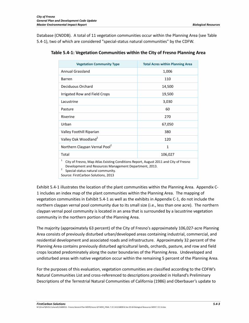
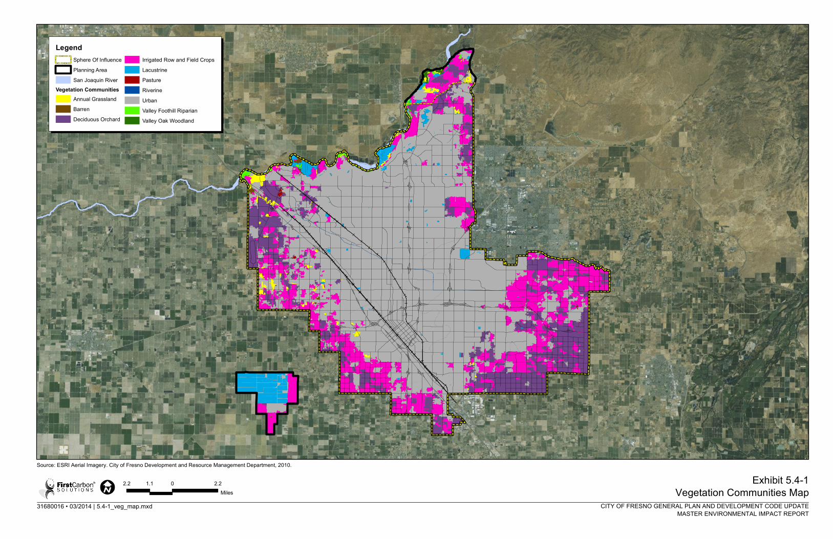
Database (CNDDB). A total of 11 vegetation communities occur within the Planning Area (see Table
5.4‐1), two of which are considered "special‐status natural communities" by the CDFW.
Table 5.4‐1: Vegetation Communities within the City of Fresno Planning Area
Vegetation Community Type Total Acres within Planning Area
Annual Grassland 1,006
Barren 110
Deciduous Orchard 14,500
Irrigated Row and Field Crops 19,500
Lacustrine 3,030
Pasture 60
Riverine 270
Urban 67,050
Valley Foothill Riparian 380
Valley Oak Woodland2 120
Northern Claypan Vernal Pool2 1
Total 106,027
1 City of Fresno, Map Atlas Existing Conditions Report, August 2011 and City of Fresno Development and Resources Management Department, 2013.
2 Special‐status natural community. Source: FirstCarbon Solutions, 2013
Exhibit 5.4‐1 illustrates the location of the plant communities within the Planning Area. Appendix C‐
1 includes an index map of the plant communities within the Planning Area. The mapping of
vegetation communities in Exhibit 5.4‐1 as well as the exhibits in Appendix C‐1, do not include the
northern claypan vernal pool community due to its small size (i.e., less than one acre). The northern
claypan vernal pool community is located in an area that is surrounded by a lacustrine vegetation
community in the northern portion of the Planning Area.
The majority (approximately 63 percent) of the City of Fresno's approximately 106,027‐acre Planning
Area consists of previously disturbed urban/developed areas containing industrial, commercial, and
residential development and associated roads and infrastructure. Approximately 32 percent of the
Planning Area contains previously disturbed agricultural lands, orchards, pasture, and row and field
crops located predominately along the outer boundaries of the Planning Area. Undeveloped and
undisturbed areas with native vegetation occur within the remaining 5 percent of the Planning Area.
For the purposes of this evaluation, vegetation communities are classified according to the CDFW’s
Natural Communities List and cross‐referenced to descriptions provided in Holland’s Preliminary
Descriptions of the Terrestrial Natural Communities of California (1986) and Oberbauer’s update to
City of Fresno General Plan and Development Code Update Biological Resources Master Environmental Impact Report
5.4‐4 FirstCarbon Solutions M:\DriveT@VOL1\shared\31680016 ‐ Fresno General Plan MEIR\Fresno GP MEIR_FINAL 7.22.14\31680016 Sec 05‐04 Biological Resources MEIR 7.22.14.doc
those descriptions (1996). The CDFW does not maintain narrative description of these vegetation
communities, so the descriptions provided below have been adapted from Holland and Oberbauer.
The vegetation maps produced for this evaluation do not imply regulatory jurisdictional
determinations under Section 404 of the Federal Clean Water Act, Section 10 of the Rivers and
Harbors Act, or Section 1600 of the California Fish and Game Code (Lake and Streambed Alteration
Program), or the lack thereof. Such determinations usually require a site visit to assess the current
conditions on the ground and to map boundaries at a finer scale than the City of Fresno General Plan
Map Atlas employs. Similarly, terms such as “riparian” and “wetland” in the vegetation keys and type
descriptions may inform, but do not imply or assert, regulatory jurisdiction or the lack thereof.
Annual Grassland
The Planning Area contains approximately 1,006 acres of annual grassland, located primarily along
the northern and western borders of the Planning Area boundary. Annual grassland in the Planning
Area includes a mix of native and non‐native, annual grasses, which often occur in association with
ruderal herbs and occasional native annual forbs. The dominant plant species within the annual
grassland vegetation community typically include black needlegrass (Nasella sp.), fescue (Vulpia sp.),
brome (Bromus sp.), and wild oats (Avena spp), with mustard (Brassica nigra), dove weed
(Eremocarpus setigerus), and poppy (Eschscholzia sp.). These grasses germinate with the fall rains,
grow during the winter and spring, and wither in the early summer.
Special‐status species with a potential to occur in the Planning Area and associated with annual
grassland habitats include:
American badger
burrowing owl California horned lark California linderiella California tiger salamander
Fresno kangaroo rat pallid bat San Joaquin kit fox San Joaquin pocket mouse
Swainson’s hawk
western mastiff bat
western spadefoot Hartweg’s golden sunburst caper‐fruited tropidocarpum
California jewel‐flower dwarf downingia spiny‐sepaled button‐celery succulent owl’s clover Greene’s tuctoria
31680016 • 03/2014 | 5.4-1_veg_map.mxd
Exhibit 5.4-1Vegetation Communities Map
Source: ESRI Aerial Imagery. City of Fresno Development and Resource Management Department, 2010.
CITY OF FRESNO GENERAL PLAN AND DEVELOPMENT CODE UPDATEMASTER ENVIRONMENTAL IMPACT REPORT
2.2 0 2.21.1Miles
LegendSphere Of InfluencePlanning AreaSan Joaquin River
Vegetation CommunitiesAnnual GrasslandBarrenDeciduous Orchard
Irrigated Row and Field CropsLacustrinePastureRiverineUrbanValley Foothill RiparianValley Oak Woodland

City of Fresno General Plan and Development Code Update Master Environmental Impact Report Biological Resources
FirstCarbon Solutions 5.4‐7 M:\DriveT@VOL1\shared\31680016 ‐ Fresno General Plan MEIR\Fresno GP MEIR_FINAL 7.22.14\31680016 Sec 05‐04 Biological Resources MEIR 7.22.14.doc
Barren
The Planning Area includes approximately 110 acres of barren land. Barren lands include areas in
which the vegetative cover comprises less than 10 percent of the surface area (disregarding natural
rock outcrops) and where there is evidence of soil surface disturbance and compaction from
previous legal human activity, and/or areas in which the vegetative cover is greater than 10 percent,
soils surface compaction is evident, and building foundations and debris are present (e.g., irrigation
piping, fencing, old wells, abandoned farming or mining equipment) from legal activities (as opposed
to illegal dumping). Barren land occurs in the northwest corner of the Planning Area, adjacent to the
San Joaquin River corridor. Vegetation within barren land has a high predominance of non‐native or
weedy species that are indicators of soil disturbance, including Russian thistle (Salsola tragus),
telegraph weed (Heterotheca grandiflora), horehound (Marrubium vulgare), and sow thistle
(Sonchus oleraceus), and a sub‐dominance of non‐native grasses.
Barren land only provides moderately suitable habitat for one special‐status species, California
horned lark.
Deciduous Orchard
Deciduous orchard communities comprise the third most abundant vegetation community in the
Planning Area, accounting for approximately 14,500 acres along the western, southern and eastern
margins of the Planning Area, where there are flat alluvial soils on valley floors, rolling foothills and
relatively steep slopes. Orchard communities are typically comprised of artificially irrigated habitat
dominated by one, sometimes several, tree or shrub species planted for cultivation. Trees are
typically low and bushy, and the understory is open, with little ground cover. In the Planning Area,
deciduous orchards include a variety of fruit trees (e.g., apples, apricots, cherries, citrus, kiwi,
peaches, nectarines, pears, persimmons, plums, pluots, pomegranates, etc.) and/or nut trees and
shrubs (e.g., almonds, olives, pistachios, walnuts, etc.) (County of Fresno 2012). Understory species
generally consist of short native and non‐native grasses and other herbaceous species.
Deciduous orchard is a relatively disturbed vegetation community and contains very little
groundcover and planted trees that provide moderately suitable habitat for only one special‐status
species, California horned lark.
Irrigated Row and Field Crops
The second most abundant vegetation community in the Planning Area is irrigated row and field
crops, accounting for 19,500 acres along the four borders of the Planning Area. This vegetation
community frequently occurs in floodplains or upland areas with high soil quality. Irrigated row and
field crows include annual and perennial crops, grown in rows, with open space between the rows.
Row and field crops are artificially irrigated and feature a moderate disturbance rate by vehicle and
pedestrian encroachment typically associated with farming activities. Species composition changes
frequently, both by season and by year.
Since irrigated row and field crops contain active agriculture, and are therefore significantly
disturbed with altered substrates, this vegetation community does not provide suitable habitat for
City of Fresno General Plan and Development Code Update Biological Resources Master Environmental Impact Report
5.4‐8 FirstCarbon Solutions M:\DriveT@VOL1\shared\31680016 ‐ Fresno General Plan MEIR\Fresno GP MEIR_FINAL 7.22.14\31680016 Sec 05‐04 Biological Resources MEIR 7.22.14.doc
any special‐status plant species and limited habitat for special‐status wildlife species. Special‐status
wildlife species with a potential to occur within this vegetation community include:
burrowing owl California horned lark Swainson’s hawk
Lacustrine
Lacustrine communities consist of standing/open waters in topographic depressions (i.e., lakes) or
dammed river channels. Lacustrine communities lack persistent emergent vegetation, but may have
submerged or floating‐leaved aquatic vegetation. Generally, lacustrine systems are surrounded by
hydrophytic plants, grasses, and trees. Lacustrine systems account for approximately 3,030 acres in
the northern portion of the Planning Area, near the San Joaquin River; within the isolated
southwestern most portion of the Planning Area; and within the isolated basins and ponds that are
interspersed throughout the City of Fresno.
Special‐status species with a potential to occur within a lacustrine community include:
western spadefoot tricolored blackbird hoary bat spotted bat western pond turtle dwarf downingia Sanford’s arrowhead
Pasture
Approximately 60 acres of pasture lands occur along the northwest corner of the Planning Area, near
deciduous orchards and other irrigated row and field crops. Pasture lands form a dense habitat with
nearly 100 percent cover; usually monoculture crops are planted in these areas, which are irrigated,
artificially seeded, and frequently maintained. Characteristic species include non‐native grasses such
as oat (Avena sp.), bermuda grass (Cynodon sp.), barley (Hordeum sp.), Sorghum grass, as well as
clover (Medicago sp.). Often times, this land contains significant areas of bare ground due to
livestock grazing and movement across acres of this vegetation community.
Special‐status species with a potential to occur within this vegetation community include:
burrowing owl California horned lark San Joaquin kit fox Swainson’s hawk
City of Fresno General Plan and Development Code Update Master Environmental Impact Report Biological Resources
FirstCarbon Solutions 5.4‐9 M:\DriveT@VOL1\shared\31680016 ‐ Fresno General Plan MEIR\Fresno GP MEIR_FINAL 7.22.14\31680016 Sec 05‐04 Biological Resources MEIR 7.22.14.doc
Riverine
Riverine systems consist of linear aquatic communities of flowing, non‐tidal waters with a distinct
channel and little to no persistent emergent vegetation. Riverine systems may also include areas
with abundant submerged or floating‐leaved aquatic vegetation. Vegetation communities abutting
riverine systems tend to be dominated by trees, shrubs, persistent emergent vegetation, and/or
emergent mosses and lichens. This vegetation community occurs near or depends upon a nearby
freshwater source or areas with fresh water flow during all or part of the year. Riverine communities
in the Planning Area account for approximately 270 acres, predominately along the northern
boundary, within the San Joaquin River system.
Special‐status species that are known to occur in riverine habitat include:
western yellow‐billed cuckoo tricolored blackbird hardhead hoary bat spotted bat western pond turtle California satintail
Urban
Urban (or developed) lands have been constructed upon or otherwise covered with a permanent,
unnatural surface (e.g., concrete, asphalt, buildings, homes, etc.) or large amount of debris or other
materials. The Planning Area consists predominately of urban areas, which are concentrated in the
central portion of the Planning Area, within the Fresno city limits. Urban land is less common within
the rural and agricultural portions of the Planning Area. Approximately 67,050 acres of the Planning
Area consist of urban land,
Urban land provides poor quality habitat for any special‐status species. No special‐status species is
expected to occur within this vegetation community.
Valley Foothill Riparian
The Planning Area includes approximately 380 acres of the valley foothill riparian community, which
occurs primarily within mature riparian forests along the San Joaquin River corridor. Valley foothill
riparian communities typically have a 20 to 80 percent canopy cover with trees that are winter
decidous. Wild grape (Vitis californica) often provides 30 to 50 percent ground cover. There is very
little herbaceous understory with the exception of disturbed openings in the canopy cover. The
understory typically consists of leaf‐litter, fallen limbs, and is often impenetrable for smaller
herbaceous plants. Tree canopy species within this community typically includes cottonwood
(Populus fremontii), California sycamore (Platanus racemosa), and valley oak (Quercus lobata).
Subcanopy species often includes white alder (Alnus rhombifolia), boxelder (Acer negundo), and
Oregon ash (Fraxinus latifolia). Typical understory shrub layer plants include wild grape, California
blackberry (Rubus ursinus), blue elderberry (Sambucus caerulea), poison oak (Toxicodendron
diversilobum), and willows (Salix sp.)
City of Fresno General Plan and Development Code Update Biological Resources Master Environmental Impact Report
5.4‐10 FirstCarbon Solutions M:\DriveT@VOL1\shared\31680016 ‐ Fresno General Plan MEIR\Fresno GP MEIR_FINAL 7.22.14\31680016 Sec 05‐04 Biological Resources MEIR 7.22.14.doc
Special‐status species with a potential to occur within valley foothill riparian habitat includes:
western spadefoot western yellow‐billed cuckoo California horned lark hoary bat spotted bat pallid bat western mastiff bat
valley elderberry longhorn beetle California satintail
Valley Oak Woodland
The Valley Oak Woodland is a special‐status natural community. The Planning Area includes
approximately 120 acres of valley oak woodland located primarily within the San Joaquin River
corridor. Valley oak woodland communities vary from open‐canopy savanna‐like woodlands to
partially closed canopy woodlands but mostly consist of winter‐deciduous, broad‐leaved species.
Valley oak (Quercus lobata), a winter‐deciduous species and California’s largest broad‐leaved tree, is
usually the only tree species present, although blue oak (Q. douglasii) may also be present. Mature
valley oaks can reach heights of 50 to 100 feet (about 15 to 35 meters). Valley oak woodlands
typically occur on deep, well‐drained alluvial soils in valley bottoms that have a higher summer
moisture content. This community intergrades with valley oak riparian near rivers and with blue oak
woodlands on drier slopes. Characteristic understory species include creeping wild rye (Elymus
triticoides), wild oats (Avena sp.), brome (Bromus sp.), barley (Hordeum zp.), needlegrass (Nassella
sp.) and poison oak (Toxicodendron diversilobum).
Special‐status species known to occur within valley oak woodland habitat includes:
western spadefoot spotted bat pallid bat western mastiff bat
San Joaquin pocket mouse
Hartweg’s golden sunburst Madera leptosiphon
Northern Claypan Vernal Pool
The northern claypan vernal pool is a special‐status natural community. The Planning Area includes
approximately one acre of northern claypan vernal pool along the northwest boundary of the
Planning Area. Typically, these pools are located within the lower elevations of the main San Joaquin
Valley. These areas are typically associated with a series of small mima mounds with interspersed
pools. Typically, these pools have highly alkaline and may display whitish salt deposits in non‐
vegetated centers of dry pools. These vernal pools are dominated by a high percentage of non‐native
species.
City of Fresno General Plan and Development Code Update Master Environmental Impact Report Biological Resources
FirstCarbon Solutions 5.4‐11 M:\DriveT@VOL1\shared\31680016 ‐ Fresno General Plan MEIR\Fresno GP MEIR_FINAL 7.22.14\31680016 Sec 05‐04 Biological Resources MEIR 7.22.14.doc
Special‐status species known to occur within northern claypan vernal pool includes:
California tiger salamander
vernal pool fairy shrimp
California linderiella molestan blister beetle
midvalley fairy shrimp
succulent owl’s clover Green’s tuctoria
Special‐status Natural Communities
As described above, the Planning Area contains two special‐status natural communities: valley oak
woodland and northern claypan vernal pool. Based on a review of the CNDDB, there are three
additional special‐status natural communities located in the vicinity of the Planning Area. These
three special‐status natural communities include the northern hardpan vernal pool, great valley
mixed riparian forest, and sycamore alluvial woodland. Each of these three special‐status natural
communities are associated with stream courses, waterways, drainages, wetlands, and seasonal
pools; however, these have not been recorded to occur within the Planning Area and are, therefore,
not likely to occur.
Special‐Status Species
The Planning Area contains potentially suitable habitat for a total of 29 special‐status species
(including 12 plant species and 17 wildlife species). Each of the special‐status species with potential
to occur (or that are known to occur) within the Planning Area is described in more detail below. A
listing of plant species was obtained from the California Native Plant Society Inventory of Rare and
Endangered Plants (See Appendix C‐2). A listing of the wildlife species was obtained from the
CNDDB (See Appendix C‐3).
Listed Plant Species
Six listed plant species have the potential to occur within the Planning Area. Impacts to these
species should be avoided to the greatest extent possible. Consultation with state and/or federal
agencies would be required in the event that a proposed project had the potential to affect a listed
plant species.
California Jewel‐Flower
California jewel‐flower (Caulanthus californicus) is a state and federally listed endangered species
and a CNPS list 1B.1 species. California jewel‐flower occurs within chenopod scrub in valley and
foothill grasslands and pinyon‐juniper woodlands. It is historically known from various valley
habitats in both the Central Valley and Carrizo Plain from 65 to 900 meters. There is one historical
known location within the Planning Area, but it is located within an area that appears to have
already been converted to urban use.
City of Fresno General Plan and Development Code Update Biological Resources Master Environmental Impact Report
5.4‐12 FirstCarbon Solutions M:\DriveT@VOL1\shared\31680016 ‐ Fresno General Plan MEIR\Fresno GP MEIR_FINAL 7.22.14\31680016 Sec 05‐04 Biological Resources MEIR 7.22.14.doc
San Joaquin Valley Orcutt Grass
San Joaquin Valley orcutt grass (Orcuttia inaequalis) is a state endangered species, a federally
threatened species, and a CNPS list 1B.1 species. This species is restricted to vernal pools at
elevations from 30 to 755 meters above sea level. There is one historic known location within the
Planning Area, near the central/western portion, just west of Highway 99.
Hairy Orcutt Grass
Hairy orcutt grass (Orcuttia pilosa) is state and federally endangered species and a CNPS list 1B.1
species. This species is restricted to vernal pools surrounded by annual grasslands. It is specifically
known to occur within the northern hardpan vernal pool community, on San Joaquin fine sandy
loam. There are no historic / known locations of this species within the Planning Area.
Hartweg’s Golden Sunburst
Hartweg’s golden sunburst (Pseudobahia bahiifolia) is state and federally endangered species and a
CNPS list 1B.1 species that is known to occur within valley and foothill grasslands and cismontane
woodlands. Hartweg’s golden sunburst is associated with clay soils, predominantly on the northern
slopes of knolls, but also along shady creeks or near vernal pools. There are no historic / known
locations of this species within the Planning Area.
Succulent Owl’s Clover
Succulent owl’s clover (Castilleja campestris ssp. succulenta) is a state endangered species, a
federally threatened species, and a CNPS list 1B.2 species. Succulent owl’s clover is isolated to vernal
pools in valley and foothill grasslands. Microhabitat requirements include moist places with acidic
soils, from 25 to 750 meters. There is one historic/known location in the Planning Area, located
within the County of Fresno (and outside of the City of Fresno sphere of influence), just south of the
San Joaquin River corridor.
Greene’s Tuctoria
Greene’s tuctoria (Tuctoria greenei) is a federally endangered species, a California Rare species, and
a CNPS list 1B.1 species. This species is known to occur within vernal pools surrounded by valley and
foothill grasslands. Specifically this species is located on dry bottoms of vernal pools from an
elevation range of 30 to 1,065 meters. There are no historic / known locations of this species within
the Planning Area.
Other Special‐Status Plant Species
In addition to the six listed plant species, there are six "other" special‐status plant species have the
potential to occur in the Planning Area: California satintail (Imperata brevifolia), Madera leptosiphon
(Leptosiphon serrulatus), hairy Orcutt grass (Orcuttia pilosa), Sanford’s arrowhead (Sagittaria
sanfordii), caper‐fruited tropidocarpum (Tropidocarpum capparideum), spiny‐sepaled button‐celery
(Eryngium spinosepalum), dwarf downingia (Downingia pusilla). Direct take of these species should
be avoided wherever possible.
City of Fresno General Plan and Development Code Update Master Environmental Impact Report Biological Resources
FirstCarbon Solutions 5.4‐13 M:\DriveT@VOL1\shared\31680016 ‐ Fresno General Plan MEIR\Fresno GP MEIR_FINAL 7.22.14\31680016 Sec 05‐04 Biological Resources MEIR 7.22.14.doc
Listed Wildlife Species
A total of eight listed wildlife species have the potential to occur or are known to occur within the
Planning Area. Project impacts to these species should be avoided to the greatest extent possible.
California Red‐Legged Frog
California Red‐Legged Frog (Rana draytoni) is a federally threatened species and a California Species
of Special Concern. The red‐legged frog is the largest native frog in California; the underside of the
hind legs and inner‐half of the feet are pink to red, which gives this frog its common name. It ranges
from Humboldt, Trinity, and Shasta counties, down the western slope of the Sierra Nevada (below
4,500 feet) to Mariposa County, and south to Mexico.
The red‐legged frog frequently uses deep, in‐channel pools in intermittent or perennial streams for
breeding and to avoid predators such as raccoons and red‐shouldered hawks. Preferred habitats
consist of deep permanent pools in stream courses characterized by a thick over‐story of willows,
sycamores, and oaks; under‐cut banks; and submerged root balls. Occupied streams are free of
exotic aquatic vertebrates such as bullfrogs, crayfish, or fish. The presence of Typha, Scirpus, and
Salix may be important indicators of potential habitat. Watercress (Rorippa nasturtium‐aquaticum)
and duckweed (Lemma sp.) tend to be the dominant understory species. Other breeding habitats
include coastal lagoons, marshes, springs, and permanent and semi‐permanent natural ponds,
backwater portions of slow streams, and large stock ponds.
California Tiger Salamander
The California tiger salamander is federally threatened within the Central Valley in California. The
Central Valley species is known to occur within grasslands and oak savannas and along the edges of
mixed woodland and lower elevation coniferous forests. This species is endemic to California, but
most of the historic range is not well known because it has been fragmented. Currently most
populations in the Central Valley have been eliminated, and the remainder are found in the
surrounding foothills from Tulare County north to Yolo County, and from Santa Barbara County to the
Sacramento Valley.
The California tiger salamander is nocturnal and fossorial, spending most of its time underground in
animal burrows, especially those of California ground squirrels and valley pocket gophers. Breeding
occurs within vernal pools or other seasonal waters. The California tiger salamander emerges at
night with the fall rains, sometimes in early November. This species needs both suitable upland
terrestrial habitat and temporary breeding ponds in order to survive.
Fresno Kangaroo Rat
Fresno kangaroo rat (Dipodomys nitratoides exilis) is state and federally listed as endangered. This
species excavates burrows in gently undulating to level terrain with sandy loam soils that are mildly
to moderately alkaline and characterized by herbaceous vegetation with scattered shrubs.
Herbaceous vegetation with scattered shrubs is common aboveground cover. Culbertson (1946)
described burrow systems as covering a surface area from about 7‐feet by 7‐feet to 12‐feet by 12‐
feet. Some burrow systems included short dead‐end tunnels, apparently used to escape predators.
City of Fresno General Plan and Development Code Update Biological Resources Master Environmental Impact Report
5.4‐14 FirstCarbon Solutions M:\DriveT@VOL1\shared\31680016 ‐ Fresno General Plan MEIR\Fresno GP MEIR_FINAL 7.22.14\31680016 Sec 05‐04 Biological Resources MEIR 7.22.14.doc
San Joaquin Kit Fox
San Joaquin kit fox (Vulpes macrotis mutica) is a state threatened species and a federally endangered
species that is in population decline, particularly in California, largely due to widespread habitat loss
from agriculture and urbanization. The species occurs from the San Joaquin Valley north to Contra
Costa and Alameda counties. This species generally prefers open, level areas with loose‐textured
soils supporting scattered, shrubby vegetation with little human disturbance.
The San Joaquin kit fox is a small grayish fox about two and one half feet in length and weighing up
to five and one half pounds. The kit fox is distinguished from other foxes by its large ears. The fox
preys on rodents, rabbits, and lizards, and in turn is preyed upon by larger carnivores, particularly
coyote.
Swainson’s Hawk
Swainson’s hawk (Buteo swainsoni) is a state threatened species that breeds regularly from
southwestern Canada to northern Mexico. Typical habitat includes open desert, grassland, or
croplands near scattered, large trees or small groves. This species nests in open riparian habitat or in
scattered trees or small groves in sparsely vegetated flatlands. While it typically roosts in large trees,
it will also roost on the ground in areas of suitable habitat, if no large trees are available. The nesting
/ breeding period for this species is from late March to mid‐August, with peak activity in late May to
late July. Swainson’s hawks build their nests on a platform of sticks, bark, and fresh leaves in a tree,
bush, or utility pole from 1.3 to 30 meters (4‐100 feet) above ground. The Swainson's hawk forages
in shrub‐steppe habitats and agricultural lands. Swainson’s hawk populations have declined
markedly since the 1920s, with steep declines in the 1950s. In some areas there have been losses of
90 to 95 percent of past populations.
Valley Elderberry Longhorn Beetle
Valley elderberry longhorn beetle (Desmocerus californicus dimorphus) is a federally threatened
species. The beetle’s current distribution is patchy throughout the remaining riparian forests of the
Central Valley, between Redding and Bakersfield. The beetle is locally common (i.e., found in
population clusters that are not evenly distributed across the Central Valley). The species is nearly
always found on or close to its host plant, elderberry (Sambucus sp.). Females lay their eggs on the
bark and larvae hatch and burrow into the stems. The larval stage may last 2 years, after which the
larvae enter the pupal stage and transform into adults. Adults are active from March to June,
feeding and mating. It appears that in order to serve as habitat, the shrubs must have stems that are
1.0 inch or greater in diameter at ground level. Use of the plants by the animal is rarely apparent.
Vernal Pool Fairy Shrimp
Vernal pool fairy shrimp (Branchinecta lynchi) is a federally threatened species. Populations of this
species are known to live in ephemeral freshwater habitats, such as vernal pools and swales. None
are known to occur in running or marine waters or other permanent bodies of water. This species
has a sporadic distribution within vernal pool complexes, wherein the majority of pools in a given
complex typically are not inhabited by the species.
City of Fresno General Plan and Development Code Update Master Environmental Impact Report Biological Resources
FirstCarbon Solutions 5.4‐15 M:\DriveT@VOL1\shared\31680016 ‐ Fresno General Plan MEIR\Fresno GP MEIR_FINAL 7.22.14\31680016 Sec 05‐04 Biological Resources MEIR 7.22.14.doc
Although the vernal pool fairy shrimp has a relatively wide range, the majority of known populations
inhabit vernal pools with clear to tea‐colored water, most commonly in grass or mud bottomed
swales, or basalt flow depression pools in unplowed grasslands, but one population occurs in
sandstone rock outcrops and another population in alkaline vernal pools (Collie and Lathrop 1976).
They are ecologically dependent on seasonal fluctuations in their habitat, such as absence or
presence of water during specific times of the year, duration of inundation, and other environmental
factors that include specific salinity, conductivity, dissolved solids, and pH levels. Water chemistry is
one of the most important factors in determining the distribution of fairy shrimp. The vernal pool
fairy shrimp occurs at temperatures between 6‐20 degrees C, in soft and poorly buffered waters.
Yellow‐Billed Cuckoo
Yellow‐billed cuckoo (Coccyzus americanus occidentalis) is a candidate for federal listing and a state
endangered species. The yellow‐billed cuckoo breeds in large blocks of riparian habitat (willow and
cottonwood stands in river floodplains). This bird feeds primarily on large insects, including
caterpillars and cicadas, and occasionally on small frogs and lizards. Breeding coincides with the
emergence of cicadas and tent caterpillar. Historically, yellow‐billed cuckoos nested primarily in
coastal counties from San Diego County, near the Mexican border, to Sonoma County, to the Central
Valley from Kern through Shasta Counties, and along the lower Colorado River. Primary threats to its
habitat include conversion of riparian habitat to agriculture, urban development, and flood control,
as well as disease, predation and lack of regulatory mechanisms.
Other Special‐status Wildlife Species
In addition to the eight listed wildlife species, there are nine "other" special‐status wildlife species
that have the potential to occur or are known to occur within the Planning Area. Direct take of these
species should be avoided and significant reductions in suitable habitat and project impacts that
result in significant population decline should be avoided to the maximum extent feasible.
American Badger
American badger (Taxidea taxus) is a California Species of Special Concern that is known to occur
within a variety of open, arid habitats, most commonly associated with grasslands, savannas,
mountain meadows, and open areas of desert scrub. Principle habitat requirements include
sufficient prey base, friable soils, and relatively open, uncultivated ground. They typically occur at
elevation ranges from below sea level to over 12,000 feet above mean sea level. American badger
habitat is threatened by habitat conversion to urban and agricultural uses, farming operations,
shooting and trapping, poisoning, and reduction of prey base because of rodent control activities.
This species occurs as far north as Canada, and as far south as central Mexico. In the United States, it
currently extends east from the Pacific coast to Texas, Oklahoma, Missouri, Illinois, Indiana, and
Ohio. In California, American badger is an uncommon, permanent resident throughout most of the
state, with the exception of the North Coast area.
Burrowing Owl
Burrowing owl (Athene cunicularia) is designated as a California Species of Special Concern.
Burrowing owls require large open expanses of sparsely vegetated areas on gently rolling or level
terrain with an abundance of active small mammal burrows. Typical habitat associated with the
City of Fresno General Plan and Development Code Update Biological Resources Master Environmental Impact Report
5.4‐16 FirstCarbon Solutions M:\DriveT@VOL1\shared\31680016 ‐ Fresno General Plan MEIR\Fresno GP MEIR_FINAL 7.22.14\31680016 Sec 05‐04 Biological Resources MEIR 7.22.14.doc
species includes short‐grass prairies, grasslands, lowland scrub, agricultural lands (particularly
rangelands), prairies, coastal dunes, desert floors, and some artificial, open areas as a year‐round
resident. Burrowing owls may also use golf courses, cemeteries, road easements and rights‐of‐way
within cities, airports, vacant lots in residential areas, and irrigation ditches.
Burrowing owls often use existing rodent burrows (or other burrows) for roosting and nesting. They
may also use pipes and culverts where burrows are scarce. If left undisturbed, a burrowing owl pair
will use the same burrow year after year for nesting
Hardhead
Hardhead (Mylopharodon conocephalus), a fish, is a California Species of Special Concern that occurs
in low to mid‐elevation streams in the Sacramento‐San Joaquin drainage and the Russian River.
Microhabitat requirements include clear, deep pools with a mix of sand, gravel and boulder bottoms
with slow water velocity. This species is not found where exotic centrarchids (commonly known as
sunfish) predominate. Populations of this species are well established in mid‐elevation reservoirs
used exclusively for hydroelectric power generation, such as the Redinger and Kerkhoff Reservoirs on
the San Joaquin River in Fresno County. Hardhead is a bottom feeder that forages for benthic
invertebrates and aquatic plant material in quiet water. They will also occasionally feed on plankton
and surface insects. This species is in decline due to predation by smallmouth bass, and damming of
large to medium‐sized warm water streams with natural flow regimes.
Pallid Bat
The pallid bat (Antrozous pallidus) is a California Species of Special Concern and a High Priority
species as designated by the Western Bat Working Group. This species ranges throughout California
and occurs within a wide range of habitat types, typically below 6,000 feet above mean sea level.
Pallid bats are non‐migratory and hibernate during the winter, during which they experience very
little activity. Pallid bats occur in a variety of habitats throughout the State and are most abundant in
xeric ecosystems. Pallid bats roost alone and in both large and small groups. Day and night roosts
include crevices in rocky outcrops and cliffs, caves, mines, trees, and human structures such as
bridges, barns, porches, bat boxes, and buildings. This species also has been found roosting on or
near the ground under stone piles, rags, and baseboards. Pallid bat is a gregarious species and often
roost in colonies of 20 to several hundred individuals. The tendency to roost gregariously, combined
with a relative sensitivity to disturbance, makes it vulnerable to mass displacement. Pallid bats are
generalists that surface glean for arthropods and capture insects on the wing. Breeding occurs from
October to February. Pups are born from late April to July and are Volant at 4 to 6 weeks of age.
Breeding colonies disperse between August and October.
Spotted Bat
The spotted bat (Euderma maculatum) is a California Species of Special Concern and a High Priority
species as designated by the Western Bat Working Group. The spotted bat is easily identifiable by its
unique coloration of dorsal black fur with three white spots, white ventral surface and long, pink
ears. In addition to being found in California, the species is known to occur in all of the states west
of (and including) Montana, Wyoming, Colorado, New Mexico and Texas. The species generally
occurs in arid, low desert habitats to high elevation conifer forests. Prominent rock features appear
City of Fresno General Plan and Development Code Update Master Environmental Impact Report Biological Resources
FirstCarbon Solutions 5.4‐17 M:\DriveT@VOL1\shared\31680016 ‐ Fresno General Plan MEIR\Fresno GP MEIR_FINAL 7.22.14\31680016 Sec 05‐04 Biological Resources MEIR 7.22.14.doc
to be a necessary feature for roosting. The winter range and hibernacula are unknown for most of
its range, though the species has been captured year‐round in the southern part of its range. This
species likely breeds in late summer with females giving birth to a single pup in early summer (May
or June). They appear to be solitary animals but occasionally roost or hibernate in small groups.
Roost sites are cracks, crevices, and caves usually high in fractured rock cliffs. In general, the long‐
term persistence of this bat, as well as most bats, is threatened by the loss of clean, open water;
modification or destruction of roosting and foraging habitat, and disturbance or destruction of
hibernacula.
Tricolored Blackbird
The tricolored blackbird (Agelaius tricolor) is a California Species of Special Concern (CSC) that
commonly occurs throughout central and coastal California. The species is often found near fresh
water, as it prefers emergent wetlands with tall, dense cattails or tules, but it can also be found in
thickets of willow, blackberry, wild rose, and other tall herbs. Tricolored blackbird is known to forage
on the ground in croplands, grassy fields, flooded land, and along the edges of ponds. The tricolored
blackbird diet generally consists of insects and spiders as a juvenile, and seeds and cultivated grains,
such as rice and oats, as an adult. The breeding season for this colonial breeding species generally
ranges from mid‐April to late July.
Western Mastiff Bat
The western mastiff bat (Eumops perotis) is a California Species of Special Concern and a High
Priority species as designated by the Western Bat Working Group. The western mastiff bat occurs
throughout California in a wide range of habitat types, typically below 9,000 feet in elevation.
Distribution is correlated with suitable rock features required for roosting. Western mastiff bats are
non‐migratory; however, they may move short distances within their home ranges. This bat species
does not hibernate and is active periodically throughout the winter. Western mastiff bat is generally
a cliff‐dwelling species, but also uses building crevices for day roosts. This species forages most
frequently in broad open areas such as flood plains, chaparral, oak woodland, open ponderosa pine
forest, grassland, montane meadows, and agricultural areas, and requires large lakes or ponds at
least 100 feet long for drinking. Western mastiff bat generally roosts high above the ground,
allowing a clear vertical drop of at least 7 feet for flight. Maternity colonies range from 30 to several
hundred individuals and generally include adult males. This species has an audible echolocation call
and is easily detected while foraging. This bat forages primarily on moths, but also takes crickets and
katydids. Breeding occurs from October to March, from which pups are born primarily in July and
are Volant at 4 to 6 weeks of age.
Western Pond Turtle
The western pond turtle (Emys marmorata) is a California Species of Special Concern that inhabits
ponds, lakes, rivers, streams, creeks, marshes and irrigation ditches containing abundant vegetation
and either rocky or muddy bottoms in woodlands, forests and grasslands. It can be found basking on
logs, rocks, cattail mats, and exposed banks within brackish water and seawater. This turtle feeds
primarily on aquatic plants, invertebrates, worms, frog and salamander eggs and larvae, crayfish,
carrion, and occasionally frogs and fish. It mates in April and May, eggs are laid sometime between
April and August, and hatchlings emerge in early fall or overwinter in the nest.
City of Fresno General Plan and Development Code Update Biological Resources Master Environmental Impact Report
5.4‐18 FirstCarbon Solutions M:\DriveT@VOL1\shared\31680016 ‐ Fresno General Plan MEIR\Fresno GP MEIR_FINAL 7.22.14\31680016 Sec 05‐04 Biological Resources MEIR 7.22.14.doc
Western Spadefoot
Western spadefoot (Spea hammondii), a California Species of Special Concern, can be found
primarily in grassland habitats and valley‐foothill hardwood woodlands. It prefers open areas with
sandy or gravelly soils in sandy washes, lowlands, river floodplains, alluvial fans, playas, alkali flats,
foothills, and mountains. Vernal pools and rain pools that do not contain bullfrogs, fish or crayfish
are necessary for breeding. The species can be found from sea level up to 4,500 feet. Western
spadefoot eats a variety of invertebrates, including adult beetles, larval and adult moths, crickets,
flies, ants, and earthworms. This species is nocturnal and almost completely terrestrial, entering
water only to breed. It can burrow underground to escape hot, arid environments, and will spend
most of its life underground. The species is typically active between October and May.
Other Wildlife Species for Consideration
Species that are not state or federally listed, and are not afforded additional state or federal
protection include: California horned lark (Eremophila alpestris actia), hoary bat (Lasiurus cinereus),
San Joaquin pocket mouse (Perognathus inornatus inornatus), California linderiella (Linderiella
occidentalis), Antioch efferian robberfly (Efferia antiochi), molestan blister beetle (Lytta molesta),
Hurd’s metapogon robberfly (Metapogon hurdi), and midvalley fairy shrimp (Branchinecta
mesovallensis).
5.4.3 ‐ Regulatory Setting
This section describes the relevant federal, state, and local (County and City) laws, regulations and
policies pertaining to environmental impacts within the Planning Area.
Federal Regulations
Federal Endangered Species Act
The United States Fish and Wildlife Service (USFWS) administers the Federal Endangered Species Act
(ESA). The ESA provides a process for listing species as either threatened or endangered and
methods of protecting listed species. The ESA defines as “endangered” any plant or animal species
that is in danger of extinction throughout all or a significant portion of its known geographic range.
A “threatened” species is a species that is likely to become endangered. A “proposed” species is one
that has been officially proposed by the USFWS for addition to the federal threatened and
endangered species list.
Per Section 9 of the ESA, “take” of threatened or endangered species is prohibited. The term “take”
means to harass, harm, pursue, hunt, shoot, wound, kill, trap, capture, or collect, or to attempt to
engage in such conduct (codified at 16 U.S.C.A. § 1532(19). "Take" can include disturbance to
habitats used by a threatened or endangered species during any portion of its life history. The
presence of any federally threatened or endangered species in a project area generally imposes
severe constraints on development, particularly if development would result in “take” of the species
or its habitat. Under the regulations of the ESA, the USFWS may authorize “take” when it is
incidental to, but not the purpose of, an otherwise lawful act.
City of Fresno General Plan and Development Code Update Master Environmental Impact Report Biological Resources
FirstCarbon Solutions 5.4‐19 M:\DriveT@VOL1\shared\31680016 ‐ Fresno General Plan MEIR\Fresno GP MEIR_FINAL 7.22.14\31680016 Sec 05‐04 Biological Resources MEIR 7.22.14.doc
Federal Clean Water Act ‐ Section 404
The US Army Corps of Engineers (USACE) administers Section 404 of the federal Clean Water Act
(CWA). This section regulates the discharge of dredge and fill material into waters of the United
States. “Discharge of fill material” is defined as the addition of fill material into waters of the United
States, including, but not limited to, the following: placement of fill that is necessary for the
construction of any structure or impoundment requiring rock, sand, dirt, or other material for the
structure’s construction; site development fills for recreational, industrial, commercial, residential,
and other uses; causeways or road fills; and fill for intake and outfall pipes and sub‐aqueous utility
lines (33 C.F.R. §328.2[f]).
The USACE has established a series of nationwide permits that authorize certain activities in waters
of the United States, if a proposed activity can demonstrate compliance with standard conditions.
Normally, USACE requires an individual permit for an activity that will affect an area equal to or in
excess of 0.5 acre of waters of the United States. Projects that result in impacts to less than 0.5 acre
can normally be conducted pursuant to one of the nationwide permits, if consistent with the
standard permit conditions. USACE also has discretionary authority to require an Environmental
Impact Statement for projects that result in impacts to an area between 0.1 and 0.5 acre. Use of any
nationwide permit is contingent on the activities having no impacts to endangered species.
Federal Clean Water Act ‐ Section 401
Per Section 401 of the CWA, “any applicant for a Federal license or permit to conduct any activity
including, but not limited to, the construction or operation of facilities, which may result in any
discharge into the navigable waters, shall provide the licensing or permitting agency a certification
from the State in which the discharge originates or will originate, or, if appropriate, from the
interstate water pollution control agency having jurisdiction over the navigable waters at the point
where the discharge originates or will originate, that any such discharge will comply with the
applicable provisions of sections 1311, 1312, 1313, 1316, and 1317 of this title" (33 U.S.C.A. §
1341(a)(1) ). Therefore, before the USACE will issue a Section 404 permit, applicants must apply for
and receive a Section 401 water quality certification from the RWQCB.
Waters of the United States
Waters of the United States, as defined in 33 Code of Federal Regulations (CFR) Section 328.3,
include all waters or tributaries to waters such as lakes, rivers, intermittent and perennial streams,
mudflats, sand‐flats, natural ponds, wetlands, wet meadows, and other aquatic habitats. Wetlands
are also included and defined as “those areas that are inundated or saturated by surface or
groundwater at a frequency and duration sufficient to support, and that under normal circumstances
do support, a prevalence of vegetation typically adapted for life in saturated soil conditions.
Wetlands generally include swamps, marshes, bogs, and similar areas” (33 C.F.R. §328.3[b]).
Frequently, waters of the United States with at least intermittently flowing water or tidal influences
are demarcated by an ordinary high water mark (OHWM). The OHWM is defined in 33 CFR Section
328.3(e) as the line on the shore established by the fluctuations of water and indicated by physical
characteristics such as a clear, natural line impressed on the bank, shelving, changes in the character
of soil, destruction of terrestrial vegetation, the presence of litter and debris, or other appropriate
City of Fresno General Plan and Development Code Update Biological Resources Master Environmental Impact Report
5.4‐20 FirstCarbon Solutions M:\DriveT@VOL1\shared\31680016 ‐ Fresno General Plan MEIR\Fresno GP MEIR_FINAL 7.22.14\31680016 Sec 05‐04 Biological Resources MEIR 7.22.14.doc
means that consider the characteristics of the surrounding areas. In this region, the OHWM is
typically indicated by the presence of an incised streambed with defined bank shelving.
In June 2001, the USACE South Pacific Division issued Guidelines for Jurisdictional Delineations for
Waters of the United States in the Arid Southwest. The purpose of this document was to provide
background information concerning physical characteristics of dryland drainage systems. These
guidelines were reviewed and used to identify jurisdictional drainage features within the Planning
Area.
Wetlands
According to the USACE Wetlands Delineation Manual, Technical Report, three criteria must be
satisfied to classify an area as a jurisdictional wetland:
A predominance of plant life that is adapted to life in wet conditions (hydrophytic vegetation)
Soils that saturate, flood, or pond long enough during the growing season to develop anaerobic conditions in the upper part (hydric soils)
Permanent or periodic inundation or soils saturation, at least seasonally (wetland hydrology)
Wetland vegetation is characterized by vegetation in which more than 50 percent of the composition
of dominant plant species are obligate wetland, facultative wetland, and/or facultative species that
occur in wetlands. As a result of the 2001 Solid Waste Agency of North Cook County (SWANCC) case,
a wetland must show connectivity to a stream course in order for such a feature to be considered
jurisdictional. Although wetland criteria was used to identify if areas were considered wetlands, the
exact limits of jurisdiction were not measured based on the standard wetland delineation protocol as
described in the 1987 USACE manual.
Migratory Bird Treaty Act
The Migratory Bird Treaty Act (MBTA) protects all common wild birds found in the United States
(U.S.) except the house sparrow, starling, feral pigeon, and resident game birds such as pheasant,
grouse, quail, and wild turkey. Resident game birds are managed separately by each state. Under
the MBTA, "it shall be unlawful at any time, by any means or in any manner, to pursue, hunt, take,
capture, kill, attempt to take, capture, or kill, possess, offer for sale, sell, offer to barter, barter, offer
to purchase, purchase, deliver for shipment, ship, export, import, cause to be shipped, exported, or
imported, deliver for transportation, transport or cause to be transported, carry or cause to be
carried, or receive for shipment, transportation, carriage, or export, any migratory bird, any part,
nest, or egg of any such bird, or any product, whether or not manufactured, which consists, or is
composed in whole or part, of any such bird or any part, nest, or egg thereof …" (16 U.S.C.A. §
703(a)).
City of Fresno General Plan and Development Code Update Master Environmental Impact Report Biological Resources
FirstCarbon Solutions 5.4‐21 M:\DriveT@VOL1\shared\31680016 ‐ Fresno General Plan MEIR\Fresno GP MEIR_FINAL 7.22.14\31680016 Sec 05‐04 Biological Resources MEIR 7.22.14.doc
California Regulations
California Endangered Species Act
The California Department of Fish and Wildlife (CDFW) administers the California Endangered
Species Act (CESA). CESA applies to "endangered" or "threatened" birds, mammals, fish,
amphibians, reptiles, and plants, but does not apply to insects (see 81 Cal. Op. Att'y Gen. 222
(1998)). The State of California considers an “endangered” species one whose prospects of survival
and reproduction are in serious danger of becoming extinct throughout all, or a significant portion,
of its range due to one or more causes, including loss of habitat, change in habitat, overexploitation,
predation, competition, or disease. Any species determined by the commission as “endangered” on
or before January 1, 1985, is an “endangered species.” A “threatened” species is one present in such
small numbers throughout its range that it is likely to become an endangered species in the
foreseeable future in the absence of special protection or management. The California Endangered
Species Act of 1970 created the categories of “Endangered” and “Rare.” The California Endangered
Species Act of 1984 created the categories of “Endangered” and “Threatened.” On January 1, 1985,
all animal species designated as “Rare” were reclassified as “Threatened” (see Fish and Game Code §
2067).
Section 2080 of the Fish and Game Code prohibits "take" of any species that the commission
determines to be an endangered species or a threatened species. Take is defined in Section 86 of the
Fish and Game Code as "hunt, pursue, catch, capture, or kill, or attempt to hunt, pursue, catch,
capture, or kill." CESA allows for take incidental to otherwise lawful development projects. CESA
emphasizes early consultation to avoid potential impacts to rare, endangered, and threatened
species and to develop appropriate mitigation planning to offset project caused losses of listed
species populations and their essential habitats.
“Candidate species” means a native species or subspecies of a bird, mammal, fish, amphibian,
reptile, or plant that the commission has formally noticed as being under review by the department
for addition to either the list of endangered species or the list of threatened species, or a species for
which the commission has published a notice of proposed regulation to add the species to either list
(Fish and Game Code § 2068).
The CDFW exercises authority over mitigation projects involving State‐listed species, including those
resulting from CEQA mitigation requirements. Lead agencies are directed by the CESA to consult
with the CDFW on projects or actions that could affect listed species. A "taking" may be authorized
by the CDFW if an approved habitat management plan or management agreement that avoids or
compensates for possible jeopardy is implemented. In addition, the CDFW requires preparation of
mitigation plans in accordance with published guidelines.
California Department of Fish and Wildlife "Species of Special Concern"
A Species of Special Concern (SSC) is a species, subspecies, or distinct population of an animal (i.e.,
fish, amphibian, reptile, bird and mammal) native to California that currently satisfies one or more of
the following (not necessarily mutually exclusive) criteria:
is extirpated from the State or, in the case of birds, in its primary seasonal or breeding role;
City of Fresno General Plan and Development Code Update Biological Resources Master Environmental Impact Report
5.4‐22 FirstCarbon Solutions M:\DriveT@VOL1\shared\31680016 ‐ Fresno General Plan MEIR\Fresno GP MEIR_FINAL 7.22.14\31680016 Sec 05‐04 Biological Resources MEIR 7.22.14.doc
is listed as Federally‐, but not State‐, threatened or endangered;
meets the State definition of threatened or endangered but has not formally been listed;
is experiencing, or formerly experienced, serious (noncyclical) population declines or range
retractions (not reversed) that, if continued or resumed, could qualify it for State threatened
or endangered status;
has naturally small populations exhibiting high susceptibility to risk from any factor(s), that if
realized, could lead to declines that would qualify it for State threatened or endangered
status.
SSCs tend to have a number of factors in common, including that they:
occur in small, isolated populations or in fragmented habitat, and are threatened by further
isolation and population reduction;
show marked population declines;
depend on a habitat that has shown substantial historical or recent declines in size and/or quality or integrity;
have few California records, or which historically occurred in the State but for which there are no recent records; and
occur largely in areas where current management practices are inconsistent with the animal's
persistence.
"Species of Special Concern" is an administrative designation that carries no formal legal status per
se, but signifies that the species is recognized as sensitive by the CDFW. Section 15380 of the CEQA
Guidelines clearly indicates that species of special concern should be included in an analysis of
project impacts if they can be shown to meet the criteria of sensitivity outlined therein.
California Native Plant Protection Act
In 1977, the Legislature formally recognized the status of rare or endangered plants with the passage
of the Native Plant Protection Act (NPPA) (Fish and Game Code, Section 1900 et seq.). The NPPA
directed the CDFW to preserve, protect, and enhance rare and endangered plants in California. The
NPPA also authorized the Fish and Game Commission to designate native plants as “rare” or
“endangered” and to require permits for collecting, transporting, or selling such plants. The
Commission listed 24 plants in 1978.
Under Section 1901 of the Fish and Game Code, “native plant” means a plant growing in a wild
uncultivated state, which is normally found native to the plant life of this state. A species, subspecies,
or variety is considered "endangered" when its prospects of survival and reproduction are in
immediate jeopardy from one or more causes. A species, subspecies, or variety is considered "rare"
when, although not presently threatened with extinction, it is in such small numbers throughout its
range that it may become endangered if its present environment worsens.
City of Fresno General Plan and Development Code Update Master Environmental Impact Report Biological Resources
FirstCarbon Solutions 5.4‐23 M:\DriveT@VOL1\shared\31680016 ‐ Fresno General Plan MEIR\Fresno GP MEIR_FINAL 7.22.14\31680016 Sec 05‐04 Biological Resources MEIR 7.22.14.doc
Under Section 1913(c) of the NPPA, the owner of land where a rare or endangered native plant is
growing is required to notify the department at least 10 days in advance of changing the land use to
allow for salvage of plant.
Fish and Wildlife Protection ‐California Fish and Game Code, Sections 1600 to 1603
The California Fish and Game Code mandates that “it is unlawful for any person to substantially
divert or obstruct the natural flow or substantially change the bed, channel, or bank of any river,
stream, or lake designated by the department, or use any material from the streambeds, without
first notifying the department of such activity.” CDFW jurisdiction includes ephemeral, intermittent,
and perennial watercourses, including dry washes, characterized by the presence of hydrophytic
vegetation, the location of definable bed and banks, and the presence of existing fish or wildlife
resources.
Furthermore, CDFW jurisdiction is often extended to habitats adjacent to watercourses, such as oak
woodlands in canyon bottoms or willow woodlands that function as part of the riparian system.
Historic court cases have further extended CDFW jurisdiction to include watercourses that seemingly
disappear, but re‐emerge elsewhere. Under the CDFW definition, a watercourse need not exhibit
evidence of an OHWM to be claimed as jurisdiction. However, CDFW does not regulate isolated
wetlands; that is, those that are not associated with a river, stream, or lake.
Porter‐Cologne Water Quality Act
The RWQCB regulates actions that would involve “discharging waste, or proposing to discharge
waste, within any region that could affect the water of the state” (Water Code Section 13260(a)),
pursuant to provisions of the Porter‐Cologne Water Quality Act. “Waters of the State” are defined as
“any surface water or groundwater, including saline waters, within the boundaries of the state”
(Water Code Section 13050 (e)).
Regional Water Quality Control Board Regulated Activities
Under Section 401 of the CWA, the RWQCB regulates all activities that are regulated by the USACE.
Additionally, under the Porter‐Cologne Water Quality Act, the RWQCB regulates all activities,
including dredging, filling, or discharge of materials into waters of the state that are not regulated by
the USACE due to a lack of connectivity with a navigable water body and/or lack of an OHWM.
California Fish and Game Code ‐ Section 3503 and Section 3511
The CDFW administers the California Fish and Game Code. There are particular sections of the Fish
and Game Code that are applicable to natural resource management. For example, Section 3503 of
the Fish and Game Code states it is unlawful to take, possess, or needlessly destroy the nest or eggs
of any bird that is protected under the MBTA. Fish and Game Code Section 3503.5 further protects
all birds in the orders Falconiformes and Strigiformes, birds of prey such as hawks and owls, and their
eggs and nests, from any form of take. Disturbance that causes nest abandonment and/or loss of
reproductive effort is also considered a “taking” by the CDFW. Fish and Game Code Section 3511
lists fully protected bird species where the CDFW is unable to authorize the issuance of permits or
licenses to take these species.
City of Fresno General Plan and Development Code Update Biological Resources Master Environmental Impact Report
5.4‐24 FirstCarbon Solutions M:\DriveT@VOL1\shared\31680016 ‐ Fresno General Plan MEIR\Fresno GP MEIR_FINAL 7.22.14\31680016 Sec 05‐04 Biological Resources MEIR 7.22.14.doc
Natural Community Conservation Planning Act ‐Fish and Game Code Sections 2800 et seq.
The State of California has adopted the Natural Community Conservation Planning and Habitat
Conservation Planning (NCCP/HCP) program to focus on creating a multiple‐species, multiple‐habitat
subregional Reserve System and implementing a long‐term “adaptive management” program. To
accomplish this, the NCCP/HCP creates a subregional habitat Reserve System and implements a
coordinated program to manage biological resources within the habitat reserve. The creating of a
defined Reserve System provides certainty to the public and to affected landowners with respect to
the location of future development and open space within the subregion. The NCCP/HCP was
developed with coordination through the CDFW and the USFWS, in order to account for the CESA
and the federal ESA.
The Planning Area does not occur within any NCCP/HCP designated area.
California Native Plant Society
The California Native Plant Society (CNPS) maintains a list of plant species native to California that
have low numbers, limited distribution, or are otherwise threatened with extinction. This
information is published in the Inventory of Rare and Endangered Plants of California. Potential
impacts to populations of CNPS‐listed plants require consideration under CEQA. The following
identifies the definitions of the California Rare Plant Ranks (formerly known as the CNPS lists):
California Rare Plant Rank 1A: Plants believed extirpated in California and either rare or extinct elsewhere.
California Rare Plant Rank 1B: Plants rare, threatened, or endangered in California and elsewhere.
California Rare Plant Rank 2A: Plants presumed extirpated in California, but more common
elsewhere.
California Rare Plant Rank 2B: Plants rare, threatened or endangered in California, but more
common elsewhere.
California Rare Plant Rank 3: Plants about which more information is needed ‐ a review list.
California Rare Plant Rank 4: Plants of limited distribution – a watch list.
The CNPS Threat Rank is an extension added onto the California Rare Plant Rank, which designates
the level of threats by a 1 to 3 ranking, with 1 being the most threatened and 3 being the least
threatened. Each threat rank is defined as follows:
0.1‐Seriously threatened in California (over 80% of occurrences threatened / high degree and immediacy of threat).
0.2‐Moderately threatened in California (20‐80% occurrences threatened / moderate degree
and immediacy of threat).
City of Fresno General Plan and Development Code Update Master Environmental Impact Report Biological Resources
FirstCarbon Solutions 5.4‐25 M:\DriveT@VOL1\shared\31680016 ‐ Fresno General Plan MEIR\Fresno GP MEIR_FINAL 7.22.14\31680016 Sec 05‐04 Biological Resources MEIR 7.22.14.doc
0.3‐Not very threatened in California (<20% of occurrences threatened / low degree and immediacy of threat or no current threats known).
County of Fresno Regulations
The County of Fresno Open Space and Conservation Element of the General Plan is concerned with
protecting and preserving natural resources, preserving open space areas, managing the production
of commodity resources, protecting and enhancing cultural resources, and providing recreational
opportunities.
The Open Space and Conservation Element sets out goals, policies, and implementation measures
under three main headings: Productive Resources, Natural Resources, and Recreation and Cultural
Resources. Productive Resources encompasses three sections: Water Resources, Forest Resources,
and Mineral Resources. Natural Resources encompass four sections: Wetland and Riparian Areas,
Fish and Wildlife Habitat, Vegetation and Air Quality. The Recreation and Cultural Resources
sections encompass: Parks and Recreation, Recreational Trails, Cultural, Geologic Resources, Scenic
Resources, and Scenic Roadways.
City of Fresno Regulations
The guidelines outlined in the City of Fresno General Plan and Municipal Codes, in conjunction with
the County of Fresno General Plan, ensure project level compliance with all applicable state and
federal regulations.
General Plan
The City of Fresno General Plan is intended to serve as a guide to enable government at all levels,
private enterprise, community groups, and individual citizens to make decisions and use community
resources in a manner that will realize progress toward a common vision of a measurably physical,
economic, and social environment. The goal of the 2025 Fresno General Plan is to provide a
mechanism to identify potential issues upfront and provide mitigation to expedite project approval
within the Planning Area. The General Plan contains specific objectives and policies to protect
biological resources within the Planning Area. These objectives and policies regarding native plants
and wildlife are outlined in Chapter 4, Resource Conservation Element, of the General Plan, as
follows:
G‐12. Objective: To provide for long‐term preservation, enhancement, and enjoyment of plant,
wildlife, and aquatic habitat resources in the Fresno area by protecting, improving, and restoring
these resources.
G‐12‐a. Policy: Support state, federal, and local programs to acquire significant habitat areas in and
near Fresno for permanent protection and/or conjunctive educational and recreational use.
G‐12‐b. Policy: The City of Fresno will participate in cooperative, multi‐jurisdictional approaches
(involving the Counties of Fresno and Madera, the City of Clovis, the San Joaquin River Conservancy,
the Metropolitan Flood Control District, and other agencies and organizations) for area‐wide habitat
City of Fresno General Plan and Development Code Update Biological Resources Master Environmental Impact Report
5.4‐26 FirstCarbon Solutions M:\DriveT@VOL1\shared\31680016 ‐ Fresno General Plan MEIR\Fresno GP MEIR_FINAL 7.22.14\31680016 Sec 05‐04 Biological Resources MEIR 7.22.14.doc
conservation plans to preserve and protect rare, threatened, and endangered species that could be
adversely affected by continued population growth and development.
G‐12‐c. Policy: In development projects, consider the incorporation of natural features (such as
ponds to be designed and managed for habitat values, or hedgerows and wooded strips) such that
these features can serve as a buffer for adjacent natural areas and/or an enhancement to the
ecological values of Fresno.
G‐12‐d. Policy: Projects that could adversely affect rare, threatened, or endangered wildlife and
vegetative species (or may have impacts on wildlife, fish, and vegetation restoration programs) may
be approved only when findings are made by the California Department of Fish and Game and the
U.S. Fish and Wildlife Service, as appropriate) that adequate mitigation measures are incorporated in
the project’s design.
G‐12‐e. Policy: Open Space land use designations, appropriate zoning, setbacks, and conservation
easements will be used to preserve areas identified as sensitive or critical habitat for rare,
threatened, or endangered vegetation and wildlife species, with particular attention paid to the
North and Southeast Growth Areas and to the preparation of the required community and/or
specific plans for these expansion areas of the proposed 2025 Fresno General Plan.
G‐12‐f. Policy: If the California Department of Fish and Game or federal conservation agencies
require habitat replacement as a condition of, or mitigation for, any development project in Fresno’s
planning area, such replacement or mitigation habitat should be located, if possible, within or near
the Fresno‐Clovis Metropolitan Area.
G‐12‐g. Policy: Mitigation programs involving restoration of natural habitats shall include measures
needed to create functional, sustainable wildlife habitat. Specific components of these programs will
include:
an evaluation of the site’s pre‐project environmental setting and the proposed design and
operating parameters of the mitigation measures, to be evaluated in the project’s CEQA/NEPA
environmental review processes.
a graphic depiction of land to be acquired or set aside for mitigation activities.
permitting required by local, state, and federal agencies for the project.
mitigation site preparation plans.
specification of the types and sources of plant material used for any revegetation.
water supply and distribution for plants and wildlife.
post‐planting maintenance and other operation measures to ensure successful mitigation.
monitoring at an appropriate frequency by qualified personnel and reporting of data collected
during monitoring to permitting agencies.
City of Fresno General Plan and Development Code Update Master Environmental Impact Report Biological Resources
FirstCarbon Solutions 5.4‐27 M:\DriveT@VOL1\shared\31680016 ‐ Fresno General Plan MEIR\Fresno GP MEIR_FINAL 7.22.14\31680016 Sec 05‐04 Biological Resources MEIR 7.22.14.doc
G‐12‐h. Policy: Establish, in consultation with appropriate public agencies with special expertise,
development and operational standards that may be needed to supplement existing law and
regulations to avoid or reduce any adverse impacts of development adjacent to important habitat
areas. Standards could include such measures as controls on noise and glare, or restrictions on
disturbance of vegetated areas.
G‐12‐i. Policy: For drainage and flood detention basins in agricultural or industrial areas, and for
those basins where design or other factors preclude developed recreational uses, Fresno
Metropolitan Flood Control District and the City of Fresno will consider development of public or
private fisheries and habitat areas for native plants and wildlife, in consultation with the state
Department of Fish and Game.
G‐12‐j. Policy: Where appropriate in flood zones along water courses and flood detention basins,
pursue development of conjunctive habitat and recreational trail uses in flood control and drainage
projects.
G‐12‐k. Policy: Encourage property owners to reestablish, maintain, and protect continuous wildlife
corridors along riparian areas, by use of building setbacks and the planting of suitable native
vegetation along the riverbanks and bluffs, streambanks, drainage or irrigation ditches, and, where
appropriate, fence lines.
G‐12‐l. Policy: Coordinate habitat restoration programs with federal, state, and local flood control
and natural resource agencies, to achieve useful restoration and take advantage of the opportunity
for a coordinated regional mitigation program, while avoiding flood control problems and the
undesirable introduction of non‐native plant and animal species.
G‐13. Objective: Maintain and restore, where feasible, the ecological values of the San Joaquin River
corridor, because (1) this area is Fresno’s main scenic feature and natural area; (2) it is important for
maintenance of good‐quality water resources in the region; and (3) it constitutes unique,
irreplaceable habitat for valley native species.
G‐13‐a. Policy: Adopted plans, codes/ordinances, regulations, and policies of the city will continue to
indicate strong concern for, and protection of, the San Joaquin River bluffs and the river bottom, to
promote Fresno’s scenic amenities and protect the river’s water quality, fisheries, and associated
riparian environment.
G‐13‐b. Policy: Support Fresno County General Plan policies which promote the preservation and
enhancement of natural resources in Fresno County’s river influence areas.
G‐13‐c. Policy: Apply, and continue to honor, the open space land use designation in the entire San
Joaquin river bottom and bluffs when considering land use decisions in the vicinity of the river.
Ensure that development projects in the vicinity of the river corridor protect and complement its
habitats and natural settings, including development within the proposed North Growth Area of the
2025 Fresno General Plan.
City of Fresno General Plan and Development Code Update Biological Resources Master Environmental Impact Report
5.4‐28 FirstCarbon Solutions M:\DriveT@VOL1\shared\31680016 ‐ Fresno General Plan MEIR\Fresno GP MEIR_FINAL 7.22.14\31680016 Sec 05‐04 Biological Resources MEIR 7.22.14.doc
G‐13‐d. Policy: Implement the multi‐use open space land use designation through the following
actions:
apply “O”/Open Conservation District or “AE‐20”/Exclusive Twenty‐Acre Agricultural District zoning when land use plans, rezonings and annexations are proposed for land on the San
Joaquin River bluffs and river bottom.
continue to prohibit new residential land use entitlements (zoning, special permits, and
subdivisions) in the river bottom, pursuant to the multi‐use open space land use designation
and zoning districts adopted for the area.
require a finding of plan consistency for all land use entitlements (including land divisions and
all types of special permits) and all infrastructure projects in the river corridor.
prohibit the location of any solid waste facilities of any type (including transfer and waste material recovery stations) in the river bottom.
adjacent to the river corridor, incorporate natural topography with respect to the design and siting of all physical improvements, in order to minimize grading and disturbances of the
viewshed.
complete studies addressing the limitations of the area’s biotic community and hydrologic
status prior to the approval of any project which involves land in, or immediately abutting, the
San Joaquin river bottom.
carefully plan and regulate outdoor lighting visible in, and from, the river corridor. In
instances where such lighting is necessary, it shall be of the lowest feasible intensity and
directed away from, or shielded from, the reserve or corridor. Adverse impacts of lighting will
be further mitigated by planting tall vegetation for screening between light sources and
wildlife corridors/reserves.
G‐13‐e. Policy: Support efforts to identify and mitigate cumulative adverse effects on aquatic life
from stormwater discharge to the San Joaquin River.
Discharge of runoff from industrial and commercial land uses to the San Joaquin River or other
riparian corridors shall be avoided.
Development entitlements for sites, which have drainage (directly or indirectly), to the San
Joaquin River or other riparian areas shall be conditioned upon adequate measures for
preventing pollution of natural bodies of water from their runoff.
Water quality and sediments shall be frequently monitored near drainage outfalls to riparian
areas.
If unacceptable levels of contaminant(s) occur, remedial measures shall be promptly
instituted.
G‐14. Objective: Support the San Joaquin River Conservancy in its efforts to develop a river parkway
that strikes an appropriate balance between facilitating recreational pursuits; protecting water
City of Fresno General Plan and Development Code Update Master Environmental Impact Report Biological Resources
FirstCarbon Solutions 5.4‐29 M:\DriveT@VOL1\shared\31680016 ‐ Fresno General Plan MEIR\Fresno GP MEIR_FINAL 7.22.14\31680016 Sec 05‐04 Biological Resources MEIR 7.22.14.doc
resources; meeting economic and development needs through sand and gravel production; and
long‐term preservation, enhancement, and public enjoyment of the river’s unique and irreplaceable
plant, wildlife, and aquatic resources.
G‐14‐a. Policy: Encourage natural reserve areas and a wildlife corridor in the river bottom to protect,
enhance, and restore riparian and aquatic habitats, adjacent wetlands, and upland areas integral to
the life cycle of river wildlife.
G‐14‐b. Policy: Natural reserves and wildlife corridors need to be acquired and expanded through
purchase, easements, mitigation for proposed activities, or other mutually satisfactory transactions.
G‐14‐c. Policy: Natural reserves should be sited where highest‐quality habitat exists adjoining the
river’s wildlife corridor and in such other location where endangered, threatened, or rare species are
established or are being reestablished.
G‐14‐d. Policy: The San Joaquin River’s wildlife corridor is to provide continuous land and water
areas parallel to the river.
A minimum width of 200 feet of riparian vegetation should be preserved on both sides of the
river. The corridor should be wider when possible and/or necessary to protect additional
areas of native plants and critical habitat (such as wildlife breeding areas). In areas where 200
feet of riparian vegetation no longer exists along the river bank, a 200‐foot or wider band of
native plants is recommended to be reestablished, to the maximum extent feasible from
topologic and hydrologic standpoints. Consider exceptions where the minimum‐width
corridor is infeasible due to topography, hydrology, or other constraints. In those instances, an
offsetting expansion is recommended on the opposite side of the river. Where steep bluffs
drop directly into or close to the river, incorporate the bluff face into the wildlife corridor.
G‐14‐e. Policy: Routine monitoring shall be done to determine the status of conditions and
mitigation measures required for projects within, and in the vicinity of, the river corridor.
A memorandum of understanding or other agreement should be implemented so that the San
Joaquin River Conservancy can perform, or participate in, this monitoring program in order to
furnish additional expertise, provide for cost efficiency, and to ensure consistency throughout
the river corridor.
Based on information obtained from monitoring, modifications in special permits, reclamation
plans, and other documents, operating parameters for uses may be necessary to insure
human health and safety and the well‐being of riparian plants and wildlife.
G‐14‐f. Policy: As specified in the San Joaquin River Parkway Master Plan and EIR (1997), natural
reserve areas and the wildlife corridor areas would be protected whenever more intensive human
uses exist or are proposed on adjacent lands. Buffer zones would allow multiple uses on parts of the
parkway while still protecting wildlife and native plants.
City of Fresno General Plan and Development Code Update Biological Resources Master Environmental Impact Report
5.4‐30 FirstCarbon Solutions M:\DriveT@VOL1\shared\31680016 ‐ Fresno General Plan MEIR\Fresno GP MEIR_FINAL 7.22.14\31680016 Sec 05‐04 Biological Resources MEIR 7.22.14.doc
Any studies done to determine appropriate buffer widths, along with the conclusions and
recommendations drawn from the studies, shall be performed by, or be reviewed and
approved by, state and federal wildlife agencies before variances from standard buffer zone
widths can be granted.
The vegetation and permitted uses of the buffer zones need to be tailored to the adjacent
habitat it is designed to protect. Natural riparian buffer zones should be maintained,
rehabilitated, or reestablished with appropriate native plants (seed material and cuttings
locally derived).
Open space uses such as pasture, low‐intensity agricultural activities, and the “rough” or marginal areas of golf courses, may be incorporated into buffer zones when they constitute an
improvement in habitat over a previous use or degraded area. However, the potential impacts
of construction, cultural, and operational practices (such as grading, number of livestock per
acre, lighting, and use of pesticides, herbicides, and fertilizers) need to be thoroughly
evaluated and addressed before these uses can be used for buffering.
Open Space and Biological Resources
Municipal Code (Section 13‐305‐Tree Preservation)
The City of Fresno Municipal Code Section13‐305 protects all public trees in the City, including but
not limited to trees that are affecting surface improvements or underground facilities or which are
diseased, or located where construction is being considered or will occur. No person, except
authorized City personnel, shall remove, destroy, deface or injure any tree on public property by any
means including but not limited to: pouring material on or immediately adjacent to any tree,
attaching any sign or notice to a tree without supervision of the Director, causing or encouraging fire
around any tree, or covering the ground within a 4‐foot radius around any tree with concrete or
other unnatural surface. Any removal of trees shall be conducted only after an evaluation and
inspection by the Director, and written authorization.
5.4.4 ‐ Thresholds of Significance
In accordance with CEQA, the effects of a project are evaluated to determine if they will result in a
significant adverse impact on the environment. The criteria used to determine the significance of an
impact to biological resources are based on the initial study checklist in Appendix G of the State
CEQA Guidelines and identified below. Accordingly, biological resource impacts resulting from the
proposed project are considered significant if the project would:
a) Have a substantial adverse effect, either directly or through habitat modifications, on any
species identified as a candidate, sensitive, or special status species in local or regional plans,
policies, or regulations, or by the California Department of Fish and Wildlife or U.S. Fish and
Wildlife Service? (See Effect on Species, Impact BIO‐1)
b) Have a substantial adverse effect on any riparian habitat or other sensitive natural community identified in local or regional plans, policies, regulations, or by the California
City of Fresno General Plan and Development Code Update Master Environmental Impact Report Biological Resources
FirstCarbon Solutions 5.4‐31 M:\DriveT@VOL1\shared\31680016 ‐ Fresno General Plan MEIR\Fresno GP MEIR_FINAL 7.22.14\31680016 Sec 05‐04 Biological Resources MEIR 7.22.14.doc
Department of Fish and Wildlife or US Fish and Wildlife Service? (See Riparian Habitat,
Impact BIO‐2)
c) Have a substantial adverse effect on federally protected wetlands as defined by Section 404 of the Clean Water Act (including, but not limited to, marsh, vernal pool, coastal, etc.)
through direct removal, filling, hydrological interruption, or other means? (BIO‐3)
d) Interfere substantially with the movement of any native resident or migratory fish or wildlife
species or with established native resident or migratory wildlife corridors, or impede the use
of native wildlife nursery sites? (See Wildlife Corridors and Nursery Sites, Impact BIO‐4)
e) Conflict with any local policies or ordinances protecting biological resources, such as a tree preservation policy or ordinance? (See Local Policies or Ordinances Protecting Biological
Resources, Impact BIO‐5)
f) Conflict with the provisions of an adopted Habitat Conservation Plan, Natural Community
Conservation Plan, or other approved local, regional, or state habitat conservation plan? (See
Conservation Plans, Impact BIO‐6)
5.4.5 ‐ Impact Analysis, Mitigation Measures, and Level of Significance After Mitigation
Effect on Species
Impact BIO‐1 The project could have a substantial adverse effect, either directly or through habitat modifications, on any species identified as a candidate, sensitive, or special status species in local or regional plans, policies, or regulations, or by the California Department of Fish and Wildlife or U.S. Fish and Wildlife Service.
Project Level Impact Analysis
Development within the Planning Area could result in the loss of natural vegetation communities
that provide suitable habitat for 30 special‐status plant and wildlife species that have the potential to
occur or are known to occur within the Planning Area. The vegetation communities within the
Planning Area boundary that provide suitable habitat for listed and other special‐status species are
described above, under Section 5.4.2 of this Master EIR. Development within the Planning Area
could result in the loss or degradation of natural habitats such as annual grassland, oak woodland,
lacustrine, riverine, and pasture, which may support special‐status plant and wildlife species.
Project‐related impacts to any of these habitat types may result in a substantial adverse effect, if it is
determined that a special‐status species will be impacted, either directly or through habitat
modifications.
Direct project impacts to species listed as a candidate, sensitive, or special‐status species by local,
state, and federal agencies should be avoided to the greatest extent feasible; however, it is
acknowledged that future projects may not be able to avoid these species. Project‐related impacts
that result in the direct take of a special‐status species may be considered a significant impact. The
presence/absence of a special‐status species on a project site and the potential to impact a special‐
status species must be determined prior to project construction. If development within the Planning
City of Fresno General Plan and Development Code Update Biological Resources Master Environmental Impact Report
5.4‐32 FirstCarbon Solutions M:\DriveT@VOL1\shared\31680016 ‐ Fresno General Plan MEIR\Fresno GP MEIR_FINAL 7.22.14\31680016 Sec 05‐04 Biological Resources MEIR 7.22.14.doc
Area results in the direct take or loss of suitable habitat for any of the 30 special‐status species that
have the potential to occur in the Planning Area, project‐level mitigation will be required. Project
impacts to special‐status species listed as threatened or endangered by CDFW and/or USFWS may
also require agency consultation and/or take permits.
Proposed projects within the Planning Area will incorporate project design features outlined in the
objectives and policies of the Fresno General Plan Update. The General Plan Update includes specific
implementing policies pertaining to biological resources that must be adhered to for development
within the Planning Area, specifically within the Open Space and Biological Resources Section of
Chapter 5, the Parks, Open Space, and Schools Element. Project‐level implementation of the General
Plan Policies POSS‐5‐a through POSS‐5‐f will reduce potential project impacts to special‐status
species and their associated habitats.
To reduce potential project‐specific impacts on biological resources, the General Plan Update
includes the following policies.
Policy POSS‐5‐a: Habitat Area Acquisition. Support state, federal, and local programs to acquire
significant habitat areas for permanent protection and/or conjunctive educational and recreational
use.
Policy POSS‐5‐b: Habitat Conservation Plans. Participate in cooperative, multi‐jurisdictional
approaches for area‐wide habitat conservation plans to preserve and protect rare, threatened, and
endangered species.
Policy POSS‐5‐c: Buffers for Natural Areas. Require development projects, where appropriate and
warranted, to incorporate natural features (such as ponds hedgerows and wooded strips) to serve as
buffers for adjacent natural areas with high ecological value.
Policy POSS‐5‐d: Guidelines for Habitat Conservation. Establish guidelines for habitat conservation
and mitigation programs. These programs will include:
An evaluation of the site’s environmental setting and proposed design and operating
parameters of proposed mitigation measures.
A graphic depiction of land to be acquired or set aside for mitigation activities.
Mitigation site preparation plans.
Specification of the types and sources of plant material used for any revegetation.
Water irrigation plans.
Post‐planting maintenance and other operational measures to ensure successful mitigation.
Monitoring at an appropriate frequency by qualified personnel and reporting of data collected
to permitting agencies.
Policy POSS‐5‐e: Pursue development of conjunctive habitat and recreational trail uses in flood
control and drainage projects.
City of Fresno General Plan and Development Code Update Master Environmental Impact Report Biological Resources
FirstCarbon Solutions 5.4‐33 M:\DriveT@VOL1\shared\31680016 ‐ Fresno General Plan MEIR\Fresno GP MEIR_FINAL 7.22.14\31680016 Sec 05‐04 Biological Resources MEIR 7.22.14.doc
Policy POSS‐5‐f: Regional Mitigation and Habitat Restoration. Coordinate habitat restoration
programs with responsible agencies to take advantage of opportunities for a coordinated regional
mitigation program.
Cumulative Impact Analysis
Development within the San Joaquin Valley study area during buildout of the Planning Area primarily
focuses on the conversion of agricultural land to development, which will reduce the availability of
suitable habitat for special‐status species, including suitable foraging habitat for raptor species.
Additionally, agricultural land and open space conversion has the potential to reduce the size, extent,
and/or quality of existing wildlife movement corridors, due to habitat fragmentation of undeveloped
open space areas within the San Joaquin Valley study area.
The loss of potentially suitable habitat for special‐status species as a result of cumulative
development would primarily result from the total conversion of agricultural and undeveloped land
to urban and rural development. This potential conversion by cumulative development is considered
a potential significant impact on special‐status species. Since the proposed project would also result
in potential significant impacts on special‐status species, the project’s contribution is considered
cumulatively considerable, and therefore, would result in a significant cumulative impact.
Mitigation Measures
Project Level
The following measures are required to be implemented to reduce the project’s impact on special‐
status species to less than significant. In addition, the implementation of the measures below would
reduce the project’s contribution to a potential significant cumulative loss of a population(s) of a
special‐status species to less than significant.
MM BIO‐1 Construction of a proposed project should avoid, where possible, vegetation
communities that provide suitable habitat for a special‐status species known to
occur within the Planning Area. If construction within potentially suitable habitat
must occur, the presence/absence of any special‐status plant or wildlife species must
be determined prior to construction, to determine if the habitat supports any
special‐status species. If a special‐status species are determined to occupy any
portion of a project site, avoidance and minimization measures shall be incorporated
into the construction phase of a project to avoid direct or incidental take of a listed
species to the greatest extent feasible.
MM BIO‐2 Direct or incidental take of any state or federally listed species should be avoided to
the greatest extent feasible. If construction of a proposed project will result in the
direct or incidental take of a listed species, consultation with the resources agencies
and/or additional permitting may be required. Agency consultation through the
CDFW 2081 and USFWS Section 7 or Section 10 permitting processes must take
place prior to any action that may result in the direct or incidental take of a listed
species. Specific mitigation measures for direct or incidental impacts to a listed
species will be determined on a case‐by‐case basis through agency consultation.

City of Fresno General Plan and Development Code Update Biological Resources Master Environmental Impact Report
5.4‐34 FirstCarbon Solutions M:\DriveT@VOL1\shared\31680016 ‐ Fresno General Plan MEIR\Fresno GP MEIR_FINAL 7.22.14\31680016 Sec 05‐04 Biological Resources MEIR 7.22.14.doc
MM BIO‐3 Development within the Planning Area should avoid, where possible, special‐status
natural communities and vegetation communities that provide suitable habitat for
special‐status species. If a proposed project will result in the loss of a special‐status
natural community or suitable habitat for special‐status species, compensatory
habitat‐based mitigation is required under CEQA and CESA. Mitigation will consist of
preserving on‐site habitat, restoring similar habitat or purchasing off‐site credits
from an approved mitigation bank. Compensatory mitigation will be determined
through consultation with the City and/or resource agencies. An appropriate
mitigation strategy and ratio will be agreed upon by the developer and lead agency
to reduce project impacts to special‐status natural communities to a less than
significant level. Agreed‐upon mitigation ratios will depend on the quality of the
habitat and presence/absence of a special‐status species. The specific mitigation for
project level impacts will be determined on a case‐by‐case basis.
MM BIO‐4 Proposed projects within the Planning Area should avoid, if possible, construction
within the general nesting season of February through August for avian species
protected under Fish and Game Code 3500 and the Migratory Bird Treaty Act
(MBTA), if it is determined that suitable nesting habitat occurs on a project site. If
construction cannot avoid the nesting season, a pre‐construction clearance survey
must be conducted to determine if any nesting birds or nesting activity is observed
on or within 500‐feet of a project site. If an active nest is observed during the
survey, a biological monitor must be on site to ensure that no proposed project
activities would impact the active nest. A suitable buffer will be established around
the active nest until the nestlings have fledged and the nest is no longer active.
Project activities may continue in the vicinity of the nest only at the discretion of the
biological monitor.
Cumulative
Implementation of Mitigation Measures BIO‐1 through BIO‐4 is required.
Level of Significance After Mitigation
Project Level
Less than significant impact.
Cumulative
Less than significant impact.
Riparian Habitat
Impact BIO‐2 The project may have a substantial adverse effect on any riparian habitat or other special‐status natural community identified in local or regional plans, policies, and regulations or by the California Department of Fish and Wildlife or U.S. Fish and Wildlife Service.
City of Fresno General Plan and Development Code Update Master Environmental Impact Report Biological Resources
FirstCarbon Solutions 5.4‐35 M:\DriveT@VOL1\shared\31680016 ‐ Fresno General Plan MEIR\Fresno GP MEIR_FINAL 7.22.14\31680016 Sec 05‐04 Biological Resources MEIR 7.22.14.doc
Project Level Impact Analysis
The Planning Area contains riparian habitat areas and special‐status natural communities, primarily
along the Planning Area boundaries. The riparian habitat within the Planning Area provides suitable
habitat for a number of special‐status plant and wildlife species known to occur in the region. There
are two (2) special‐status natural communities with a potential to occur within the Planning Area:
northern claypan vernal pool and valley oak woodland. Planned development within the Planning
Area is primarily limited to existing disturbed, developed and agricultural areas located around the
geographic center of the Planning Area. However, as development continues within the Planning
Area, it likely will continue towards existing water features. Future development that occurs in the
vicinity of the San Joaquin River, its tributaries, any lakes or streams, and/or open grasslands with
seasonal wetlands, may result in a significant impact to riparian habitat or a special‐status natural
community. The presence of riparian habitat and/or a special‐status natural community on a project
site must be evaluated prior to project approval. Any project‐related impacts to riparian habitat
and/or a special‐status natural community are considered a significant impact and require
mitigation.
Project level implementation of the General Plan Implementing Policies POSS‐6‐a through POSS‐7‐d
will reduce potential project impacts to riparian habitat, and areas such as the San Joaquin River
corridor.
Objective POSS‐6: Maintain and restore, where feasible, the ecological values of the San Joaquin
River corridor.
Policy POSS‐6‐a: San Joaquin River Parkway Master Plan. Update the San Joaquin River Parkway
Master Plan, working with the other jurisdictions and the River Conservancy, to create a
comprehensive and feasible plan for preservation, conservation, and development.
Policy POSS‐6‐b: Effects of Stormwater Discharge. Support efforts to identify and mitigate
cumulative adverse effects on aquatic life from stormwater discharge to the San Joaquin River.
Discharge of runoff from industrial and commercial land uses to the San Joaquin River or other
riparian corridors shall be avoided.
Approve development on sites having drainage (directly or indirectly) to the San Joaquin River
or other riparian areas upon a finding that adequate measures for preventing pollution of
natural bodies of water from their runoff will be implemented.
Periodically monitor water quality and sediments near drainage outfalls to riparian areas. If
unacceptable levels of contaminant(s) occur, remedial measures shall be promptly instituted.
Object POSS‐7: Support the San Joaquin River Conservancy in its efforts to develop a river parkway.
Policy POSS‐7‐a: Preserve Wildlife Corridors. Acquire and expand natural reserves and wildlife
corridors through purchase, easements, mitigation for proposed activities, or other mutually
satisfactory transactions.
City of Fresno General Plan and Development Code Update Biological Resources Master Environmental Impact Report
5.4‐36 FirstCarbon Solutions M:\DriveT@VOL1\shared\31680016 ‐ Fresno General Plan MEIR\Fresno GP MEIR_FINAL 7.22.14\31680016 Sec 05‐04 Biological Resources MEIR 7.22.14.doc
Policy POSS‐7‐b: Wildlife Corridor along San Joaquin River. Create a wildlife corridor to provide
continuous land and water areas parallel to the San Joaquin River.
A minimum width of 200 feet of riparian vegetation should be preserved on both sides of the river.
The corridor should be wider when possible and/or necessary to protect additional areas of native
plants and critical habitat (such as wildlife breeding areas). In areas where 200 feet of riparian
vegetation no longer exists along the river bank, a 200‐foot or wider band of native plants is
recommended to be reestablished, to the maximum extent feasible from topologic and hydrologic
standpoints. Consider exceptions where the minimum‐width corridor is infeasible due to topography,
hydrology, or other constraints. In those instances, an offsetting expansion is recommended on the
opposite side of the river. Where steep bluffs drop directly into or close to the river, incorporate the
bluff face into the wildlife corridor.
Policy POSS‐7‐c: Monitoring River Corridor Conditions. Undertake periodic monitoring to
determine the status of conditions and mitigation measures required for projects within, and in the
vicinity of, the river corridor.
A memorandum of understanding or other agreement should be executed so that the San
Joaquin River Conservancy can perform, or participate in, this monitoring program in order to
furnish additional expertise, provide for cost efficiency, and to ensure consistency throughout
the river corridor.
Based on information obtained from monitoring, modifications in special permits, reclamation
plans, and other documents, operating parameters for uses may be necessary to insure
human health and safety and the well‐being of riparian plants and wildlife.
Policy POSS‐7‐d: Buffer Zones near Intensive Uses. Protect natural reserve areas and the wildlife
corridor areas in the River Corridor whenever more intensive human uses exist or are proposed on
adjacent lands. Buffer zones will allow multiple uses on parts of the parkway while still protecting
wildlife and native plants.
Require studies of appropriate buffer widths to be approved by state and federal wildlife agencies before variances from standard buffer zone widths are granted.
Maintain natural riparian buffer zones with appropriate native plants (seed material and
cuttings locally derived).
Incorporate open space uses such as pasture, low‐intensity agricultural activities, and the “rough” or
marginal areas of golf courses, into buffer zones when they constitute an improvement in habitat
over a previous use or degraded area. However, the potential impacts of construction, cultural, and
operational practices (such as grading, number of livestock per acre, lighting, and use of pesticides,
herbicides, and fertilizers) will need to be thoroughly evaluated and addressed before these uses can
be approved for buffer zones.
City of Fresno General Plan and Development Code Update Master Environmental Impact Report Biological Resources
FirstCarbon Solutions 5.4‐37 M:\DriveT@VOL1\shared\31680016 ‐ Fresno General Plan MEIR\Fresno GP MEIR_FINAL 7.22.14\31680016 Sec 05‐04 Biological Resources MEIR 7.22.14.doc
With the implementation of the above objectives and policies, potential impacts to riparian habitat
areas would be reduced; however, the impact would remain significant.
Cumulative Impact Analysis
Implementation of cumulative development within the San Joaquin Valley could result in potential
impacts to riparian habitat. Cumulative development could encroach into areas adjacent to existing
rivers and streams that could contain riparian habitat. In addition, cumulative development near the
San Joaquin River corridor could result in potential impacts on riparian habitat. Since development
in accordance with the General Plan Update could result in potential impacts on riparian habitat, the
project’s contribution to cumulative impacts would be considerable and would represent a
significant cumulative impact.
Mitigation Measures
Project Level
MM BIO‐5 If a proposed project will result in the removal or impact to any riparian habitat
and/or a special‐status natural community with potential to occur in the Planning
Area, compensatory habitat‐based mitigation shall be required to reduce project
impacts. Compensatory mitigation must involve the preservation or restoration or
the purchase of off‐site mitigation credits for impacts to riparian habitat and/or a
special‐status natural community. Mitigation must be conducted in‐kind or within
an approved mitigation bank in the region. The specific mitigation ratio for habitat‐
based mitigation will be determined through consultation with the appropriate
agency (i.e., CDFW or USFWS) on a case‐by‐case basis.
MM BIO‐6 Project impacts that occur to riparian habitat may also result in significant impacts to
streambeds or waterways protected under Section 1600 of Fish and Wildlife Code
and Section 404 of the CWA. CDFW and/or USACE consultation, determination of
mitigation strategy, and regulatory permitting to reduce impacts, as required for
projects that remove riparian habitat and/or alter a streambed or waterway, shall be
implemented.
MM BIO‐7 Project‐related impacts to riparian habitat or a special‐status natural community
may result in direct or incidental impacts to special‐status species associated with
riparian or wetland habitats. Project impacts to special‐status species associated
with riparian habitat shall be mitigated through agency consultation, development
of a mitigation strategy, and/or issuing incidental take permits for the specific
special‐status species, as determined by the CDFW and/or USFWS.
Cumulative
Implementation of Mitigation Measures BIO‐5 through BIO‐7 is required.
Level of Significance After Mitigation
Project Level
Less than significant impact.
City of Fresno General Plan and Development Code Update Biological Resources Master Environmental Impact Report
5.4‐38 FirstCarbon Solutions M:\DriveT@VOL1\shared\31680016 ‐ Fresno General Plan MEIR\Fresno GP MEIR_FINAL 7.22.14\31680016 Sec 05‐04 Biological Resources MEIR 7.22.14.doc
Cumulative
Less than significant impact.
Federally Protected Wetlands
Impact BIO‐3 The project could have a substantial adverse effect on federally protected wetlands as defined by Section 404 of the Clean Water Act (including, but not limited to, marsh, vernal pool, coastal, etc.) through direct removal, filling, hydrological interruption, or other means.
Project Level Impact Analysis
Development within the Planning Area, particularly in undeveloped areas, could result in the loss of
jurisdictional wetland habitat, which includes vernal pools, seasonal wetlands, waters of the U.S. or
intermittent/permanent water bodies. Proposed projects that encroach into grassland, agricultural,
lake or riverine areas may result in the significant disturbance and/or fill of potentially jurisdictional
wetlands. Any project‐related impacts that result in the significant alteration or fill of a federally
protected wetland is considered a significant impact. Additionally, special‐status species associated
with wetlands and vernal pool habitats, such as vernal pool fairy shrimp, may be impacted as a result
of project impacts to protected wetlands. Project‐specific agency (i.e., CDFW, RWQCB, and/or USACE
coordination and/or regulatory permitting would be required to reduce project impacts to wetland
habitat.
The implementation of Policies POSS‐6‐a through POSS‐7‐d, as listed in Impact BIO‐2, would reduce
potential project impacts to wetlands and wetland habitat, and areas such as the San Joaquin River
corridor.
Cumulative Impact Analysis
The conversion of grassland and undeveloped areas to cumulative development, within the San
Joaquin Valley, may increase effects on protected wetland habitats. Cumulative development that
encroaches into wetland habitat areas or indirectly impacts wetland habitat through the increase of
upstream urban runoff could result in significant impact. Since the development in accordance with
the General Plan Update could increase impacts on wetland habitats, the project’s contribution to
potential impacts on wetland habitat is cumulatively considerable. Thus, the proposed project
would result in a significant cumulative impact.
Mitigation Measures
Project Level
MM BIO‐8 If a proposed project will result in the significant alteration or fill of a federally
protected wetland, a formal wetland delineation conducted according to USACE
accepted methodology is required for each project to determine the extent of
wetlands on a project site. The delineation shall be used to determine if federal
permitting and mitigation strategy are required to reduce project impacts.
Acquisition of permits from USACE for the fill of wetlands and USACE approval of a
wetland mitigation plan would ensure a “no net loss” of wetland habitat within the
City of Fresno General Plan and Development Code Update Master Environmental Impact Report Biological Resources
FirstCarbon Solutions 5.4‐39 M:\DriveT@VOL1\shared\31680016 ‐ Fresno General Plan MEIR\Fresno GP MEIR_FINAL 7.22.14\31680016 Sec 05‐04 Biological Resources MEIR 7.22.14.doc
Planning Area. Appropriate wetland mitigation/creation shall be implemented in a
ratio according to the size of the impacted wetland.
MM BIO‐9 In addition to regulatory agency permitting, Best Management Practices identified
from a list provided by the USACE shall be incorporated into the design and
construction phase of the project to ensure that no pollutants or siltation drain into
a federally protected wetland. Project design features such as fencing, appropriate
drainage and incorporating detention basins shall assist in ensuring project‐related
impacts to wetland habitat are minimized to the greatest extent feasible.
Cumulative
Implementation of Mitigation Measures BIO‐8 and BIO‐9 are required.
Level of Significance After Mitigation
Project Level
Less than significant impact.
Cumulative
Less than significant impact.
Wildlife Corridors and Nursery Sites
Impact BIO‐4 The project would not interfere substantially with the movement of any native resident or migratory fish or wildlife species or with established native resident or migratory wildlife corridors, or impede the use of wildlife nursery sites.
Project Level Impact Analysis
Project development within the Planning Area is primarily focused on existing disturbed and
developed areas situated near the geographic center of the Planning Area. These areas are mainly
surrounded by existing development and disturbed habitat areas. The majority of habitat within the
Planning Area consists of urban areas characterized by disturbed land and development. Planned
land use within the Planning Area includes residential, commercial, industrial, and associated
infrastructure.
Open space areas, undeveloped land, and agricultural land are mainly located along the boundaries
of the Planning Area, particularly near the northern boundary along the San Joaquin River corridor.
The San Joaquin River corridor functions as a wildlife movement corridor for a number of terrestrial
and aquatic mammals and birds. The San Joaquin River corridor facilitates movement of wildlife
species from the Planning Area to the Sierra Nevada Mountains to the east and open agricultural
land to the west. The proposed project could include development within and adjacent to the San
Joaquin River corridor. This development could result in potential impacts to the wildlife movement
corridor. The General Plan Update includes policies POSS‐6‐a through POSS‐7‐d that would reduce
impacts to species that use the San Joaquin River corridor as a wildlife movement corridor by
providing buffer zones, control stormwater runoff, and providing periodic monitoring of the
City of Fresno General Plan and Development Code Update Biological Resources Master Environmental Impact Report
5.4‐40 FirstCarbon Solutions M:\DriveT@VOL1\shared\31680016 ‐ Fresno General Plan MEIR\Fresno GP MEIR_FINAL 7.22.14\31680016 Sec 05‐04 Biological Resources MEIR 7.22.14.doc
biological resource conditions. These policies would reduce potential impacts to wildlife movement
corridors along the San Joaquin River to less than significant.
In the remaining portions of the Planning Area, there are open space parks and recreational use
areas, but these areas are scattered throughout the Planning Area. Due to the isolation of these
areas, there are no substantive linkages to consider them as part of a wildlife movement corridor.
Therefore, implementation of future development within the Planning Area in accordance with the
General Plan Update would result in less than significant impacts on wildlife movement corridors.
Cumulative Impact Analysis
The San Joaquin Valley study area contains vast areas of agricultural land, open space areas, several
rivers and mountains that serve to facilitate wildlife movement across the San Joaquin Valley study
area and most of the Central Valley. Development within the Planning Area and cities within the San
Joaquin Valley study area are characterized by existing disturbed and developed land. As
development has occurred over the years, it has been within or immediately adjacent to the existing
cities and communities within the San Joaquin Valley study area. Open areas for wildlife movement
typically occur outside cities and communities within the study area, particularly along river
corridors, connected open space, and the foothills along the east and west sides of the valley.
Development within the San Joaquin Valley study area could have a significant impact on wildlife
movement corridors. However, the project’s potential contribution to cumulative impacts on wildlife
movement corridors is less than cumulatively considerable. Thus, the project’s cumulative impacts
to potential wildlife movement corridors or wildlife nursery sites within the San Joaquin Valley study
area, through development of the Planning Area, are considered less than significant.
Mitigation Measures
Project Level
No mitigation measures are required.
Cumulative
No mitigation measures are required.
Level of Significance After Mitigation
Project Level
Less than significant impact.
Cumulative
Less than significant impact.
Local Policies or Ordinances Protecting Biological Resources
Impact BIO‐5 The project would not conflict with any local policies or ordinances protecting biological resources, such as a tree preservation policy or ordinance.
City of Fresno General Plan and Development Code Update Master Environmental Impact Report Biological Resources
FirstCarbon Solutions 5.4‐41 M:\DriveT@VOL1\shared\31680016 ‐ Fresno General Plan MEIR\Fresno GP MEIR_FINAL 7.22.14\31680016 Sec 05‐04 Biological Resources MEIR 7.22.14.doc
Project Level Impact Analysis
Project development within the Planning Area may result in the removal or alteration of existing
street and public trees within the boundaries of the Planning Area. Existing preserved trees and
landscaped trees within public property, including parkways, must be preserved in order to beautify
the City, purify its air, and provide shade for its inhabitants. Project development within the Planning
Area could have the potential to impact trees on public property; however, the future development
would be required to comply with Article 3 of Section 13 of the City of Fresno Municipal Code.
Therefore, potential impact to the City’s public tree ordinance would be less than significant.
Cumulative Impact Analysis
Implementation of cumulative development throughout the San Joaquin Valley would primarily not
impact trees within public property of the Planning Area. However, there could be other cumulative
projects within the Planning Area, such as the High Speed Rail project, that could impacts trees
within public property. Since cumulative development within the Planning Area as well as
development in accordance with the General Plan Update would be required to comply with Article
3 of Section 13 of the City of Fresno Municipal Code, potential impacts on trees within public
property would be less than significant. Therefore, the project’s contribution to potential cumulative
impacts on the City’s public tree ordinance would be less than cumulatively considerable and thus a
less than significant cumulative impact.
Mitigation Measures
Project Level
No mitigation measures are required.
Cumulative
No mitigation measures are required.
Level of Significance After Mitigation
Project Level
Less than significant impact.
Cumulative
Less than significant impact.
Conservation Plans
Impact BIO‐6 A project would not conflict with the provisions of an adopted Habitat Conservation Plan, Natural Community Conservation Plan, or other approved local, regional, or state habitat conservation plan.
Project Level Impact Analysis
The City of Fresno Planning Area is not located within the boundaries of any approved or draft
Habitat Conservation Plan (HCP), Natural Community Conservation Plan (NCCP), or other adopted
City of Fresno General Plan and Development Code Update Biological Resources Master Environmental Impact Report
5.4‐42 FirstCarbon Solutions M:\DriveT@VOL1\shared\31680016 ‐ Fresno General Plan MEIR\Fresno GP MEIR_FINAL 7.22.14\31680016 Sec 05‐04 Biological Resources MEIR 7.22.14.doc
local, regional or state HCP. Therefore, development within the Planning Area will not result in any
impacts to an adopted HCP or NCCP.
Cumulative Impact Analysis
Within the San Joaquin Valley, there is currently only one habitat conservation plan, the
Metropolitan Bakersfield Habitat Conservation Plan (MBHCP). Cumulative development within the
MBHCP could result in impacts to the plan. Since the City of Fresno Planning Area is not located
within the MBHCP or any other HCP, development in accordance with the General Plan Update
would not contribute to any potential cumulative impacts on a HCP. Therefore, the proposed project
would result in no cumulative impacts.
Mitigation Measures
Project Level
No mitigation measures are required.
Cumulative
No mitigation measures are required.
Level of Significance After Mitigation
Project Specific
No impact.
Cumulative
No impact.