Embed Size (px)
Citation preview
RIPARIAN CORRIDOR STUDYFINAL CITY CREEK MANAGEMENT PLAN
SALT LAKE CITY OCTOBER 2010
DEPARTMENT OF PUBLIC UTILITIES BIO-WEST, INC.5-1
5.0 RIPARIAN CORRIDOR VISION
Summaryof Stakeholder Input
This section provides a summaryof the input received duringpublic outreach activitiesthroughout the planning process. Because the RCS public outreachactivities centered around aseries of two public workshops,the input received is summarizedbelow according to publicworkshop.
Public Workshop 1
During the first public workshop,much of the input receivedfocused on questions about theinformation collected as part ofthe RCS planning process andconcerns regarding past resourcemanagement activities by theCity along the riparian corridor. A number of participantsexpressed concern over theproposed vegetationmanagement within the canyonfor fire control. Othersquestioned the inclusion of theconcrete channel through lowerCity Creek into the study area, aswell as the origin of the suds-laden water that enters CityCreek from storm drains duringstorm events. Concerns aboutfuture seismic activity, thecontinued use of gabion basketretaining walls along the creek,and the continued need for theroad along lower City Creek
were also expressed by thosewho attended the first publicworkshop.
Participants also provided anumber of suggestions forconsideration in the RCSmanagement plan. Theseincluded suggestions forincorporating scientific decision-making criteria into the process,maximizing the use of the studyarea as an educationaldestination, and recognizing CityCreek as an easy escape fromdowntown. In addition, somesuggested that the visionstatement may require twosections to acknowledge thedifferences between upper andlower City Creek. Anothersuggestion was to consider userfees to help pay for managementand maintenance of the CityCreek RCS.
The following is a summary ofthe questions asked and theresponses received on theworkshop response forms thatwere distributed at the first publicworkshop.
What Riparian CorridorFunctions Are Important ToYou?
• Cooler temperatures,channel stability, wildlifehabitat, shading,floodplain connectivity,biodiversity andaesthetics.
What Concerns Do You HaveFor The Riparian Corridor?
• I have no concerns aboutCity Creek throughMemory Grove or thearea downstream. It isclearly an urban areawhere the ripariancorridor strictly functionsfor aesthetic purposes. Upstream of MemoryGrove, I have thefollowing concerns: Lackof herbaceous vegetationcover, soil erosion,unstable/hardenedstream banks,inappropriate orproblematic in-streamstructures, invasiveweeds, fear of City fireprevention efforts.
What Suggestions Do You HaveFor Restoration and RemediationProjects?
• City Creek canyon islargely undevelopedexcept for the areaimmediately downstreamof Memory Grove. Between Memory Groveand Bonneville Drive, theriparian corridor suffersfrom many of the sameproblems as ParleysCreek within Parleys Parkor Sugar House Park. Ifmanagers want to restoresome function to this
RIPARIAN CORRIDOR STUDYFINAL CITY CREEK MANAGEMENT PLAN
SALT LAKE CITY OCTOBER 2010
DEPARTMENT OF PUBLIC UTILITIES BIO-WEST, INC.5-2
section, they couldconsider creatingdesignated trails toconcentrate use andallow for revegetation. The corridor is so narrowthat it would be difficultto maintain the road onthe west side andunpaved trails on the eastside. An option would beto completely close theeast side of the creek topeople and concentratethem on the west sideroad. Depending on howwide the road needs tobe, the City couldremove some of theasphalt and replace itwith a more natural trailso that hikers and bikersare separated. Otherwise, I’d like to seemanagers remove and/orreplace existing man-made structures such aspoorly built bridges, rip
rap, failing culverts, andhardened stream accesspoints. I’d like to seerevegetation of theherbaceous and shrublayer, and removal ofinvasive weeds (ifpossible).
The City Creek riparian corridoris . . .
• a valuable Salt Lake Cityamenity and functions fora number of purposesincluding recreation,water supply and wildlifehabitat. It is unique inthat it is managedprimarily by one entity:Salt Lake City. Therefore, there arefewer competing interestsand more opportunity forconsistent managementalong the length of thecorridor.
We envision a riparian corridorthat . . .
• can sustain cool summertemperatures and cleanwater. I also envision acorridor that is restoredand maintained for adiversity of wildlifeincluding coldwater fish,birds, amphibians, andmacro-invertebrates. Ienvision a sharpdistinction inmanagement betweenthe area below andabove Bonneville Drive. The area below could bemanaged for people, andthe area above could bemanaged for wildlife andwater quality.
Public Workshop 2
During public workshop 2, mapsof individual stream reaches wereposted for review and comments. Participants with interest inspecific reaches were asked toreview the relevant maps andprovide reach-specific input oncomment forms attached to themaps. The comment formsasked the question “Whatriparian function, values, orimprovement projects do youthink are high priority within thisstream reach specifically?” Inputgathered during this exercise isincluded in Appendix C, whichalso provides maps, data, andrecommendations for individualstream reaches.
RIPARIAN CORRIDOR STUDYFINAL CITY CREEK MANAGEMENT PLAN
SALT LAKE CITY OCTOBER 2010
DEPARTMENT OF PUBLIC UTILITIES BIO-WEST, INC.5-3
A variety of other more generalconcerns and questions were alsoexpressed during the secondpublic workshop. Severalparticipants expressed concernregarding the oil pipelines andother “wet” utilities that crossCity Creek in light of the recentpetroleum pipeline failure at RedButte Creek. Another concernregarded the numerous “bridges”(utility culverts) that cross thecreek and are not safe or welldesigned for pedestrian use. Some participants indicated thatthey feel that riparian corridorsand off-leash dog areas are notcompatible; other participantsexpressed that maintaining wateraccess for dogs is very importantto them. One participantquestioned what happens to thestream banks once invasivevegetation is removed.
Suggestions from participantsincluded making sure there is anappropriate location for dogs toaccess the creek, installing localshut-off valves on petroleumpipelines that cross the creek,and protecting stream-siderestoration areas with temporaryfencing until established. Additional suggestions includedusing goats for weed control inthe canyon and considering thefeasibility of installing small-scalehydro-electric systems in theunderground portions of thecreeks. Another suggestion froma participant was to maintainsome more dynamic bankerosion areas, low-lying shrubs,
and standing dead trees forwildlife habitat.
Workshop participants alsoencouraged adding moreinformation about the fire fuelbreak study, existing waterquality reports, and geologyinformation to the RCSdocument. Following the secondworkshop, several additional setsof written comments werereceived from subcommitteemembers and other interestedstakeholders. Most of thesecomments suggested specificedits or additions to the RCSreport that have beenincorporated in this final RCSdocument.
Meeting with Cityand County ManagementEntities
Salt Lake City owns andmanages the entire City Creekriparian corridor within the RCSstudy area. Salt Lake County’sEngineering and Flood ControlDivision maintains the debrisbasins adjacent to BonnevilleBoulevard. Because theseentities are major stakeholderswithin the corridor, a meetingwas held with City and Countystaff on April 30, 2010 to discussthe RCS process and obtaininput.
The Memory Grove area, whichencompasses study reachesLCC_R01A through LCC_02B, ismanaged and maintained by theCity’s Parks Division. Priorities
identified by Parks Division staffincluded recreational safety,particularly along the paved trailon the western bank of the creekthat receives shared use amongpeople walking, biking, roller-blading, jogging, and dog-walking. Various staff at the April30 meeting also indicated aninterest in maintaining adequatewidth on this paved trail toaccommodate emergencyvehicles. Parks staff alsoexplained that no “official” trailsexist on the east side of the creekupstream of the brown footbridgein reach LCC_R01B; existingtrails in this area are all user-created. Some interest wasexpressed in the possibility ofcreating a formal trail accesspoint somewhere near thedownstream end of reachLCC_R01A that would linkeastern Bonneville Boulevard tothe paved trail on the west sideof the creek via a new footbridge. This could facilitate efforts toreclaim user-created trails in thisarea and improve bank andslope stability.
County Flood Control staffindicated an interest inestablishing a more defined,stabilized access ramp at theupper debris basin to facilitatedredging access. However, Cityand County staff agreed that theidea of establishing a fishingaccess ramp in this locationwould not be feasible orcompatible with the use of thebasin as a debris and floodcontrol structure. Space
RIPARIAN CORRIDOR STUDYFINAL CITY CREEK MANAGEMENT PLAN
SALT LAKE CITY OCTOBER 2010
DEPARTMENT OF PUBLIC UTILITIES BIO-WEST, INC.5-4
constraints in the area alreadypresent a challenge inaccommodating trail headparking and flood controlequipment access.
The upper portion of the RCSstudy area (reaches UCC_R09through UCC_R11C) is managedby the City’s Watershed Division. Priorities in this area includeensuring that City Creek CanyonRoad is maintained in a safecondition to allow ready accessto the CCWTP by City vehiclesand equipment. Vegetationmanagement to control invasiveweeds and to reduce fire riskalong the roadway are otherconcerns in this area. The City isalso interested in improvingroadway safety in this portion ofthe canyon.
City Creek RiparianCorridor VisionStatement
Public and stakeholder inputwere used to develop a visionstatement for the City Creekriparian corridor. The visionstatement uses introductory textthat describes the desired futurecondition of the corridor,followed by supporting text thatidentifies more specific targetsand objectives. The closing textof the vision statement providesgeneral guidance on how toachieve the desired futurecondition for the corridor. TheCity Creek riparian corridorvision statement is intended to bea “living” and adaptive planning
City Creek vision statement:
The City Creek riparian corridor is a thriving ecosystem and highly valueddestination in Salt Lake City that provides an escape from the urbanenvironment for people, plants, and wildlife. Our community appreciates thecorridor for its solitude and revitalizing atmosphere, as well as for theeducational and recreational benefits of this unique riparian area and free-flowing stream. Through ongoing cooperative efforts, the community hassupported the riparian ecosystem and it is restored to the extent possible,promoting stewardship of the environment and providing education on thefunctions of a sustainable natural ecosystem featuring fish and wildlife habitat,visual aesthetics, native vegetation, and excellent stream water quality.
To achieve this vision, the following riparian corridor functions must berealized:
• A well-connected vegetative corridor provides a diverse habitat for nativewildlife and migrating bird species
• Healthy, mature vegetation provides a canopy to cool air and watertemperatures; mid-level vegetation and ground cover allow for diverse fishand wildlife habitat, erosion control, and filtration of sediment andpollutants.
• An uninterrupted flow of clean, clear water supports a healthy native coldwater fishery and a riparian ecosystem of native plants.
• Stream banks are stable but allow for natural stream dynamics withinacceptable limits.
• The stream is recognized as a valuable asset by the community, with trash,debris and noxious weeds kept out of the stream bed and riparian corridor.
• Preserved open space compliments the riparian corridor and provides apromenade for diverse outdoor enthusiasts, while allowing for safe andaccessible public enjoyment of the stream environment for all abilities.
• Storm water conveyances are designed and upgraded to improve streamstability and water quality.
• Infrastructure along the stream is replaced as appropriate to reduce streamchannel constrictions and improve stream bed and bank stability.
These goals will be achieved with cooperation between the City and thecommunity using science based decision making criteria and consistentmanagement along the entire length of the City Creek riparian corridor. Accomplishment of rehabilitation projects will depend on their prioritizationand available funding. Priorities for the riparian corridor below BonnevilleBoulevard will emphasize public access for recreational and educational orinterpretive opportunities. Priorities for the riparian corridor above BonnevilleBoulevard will emphasize preservation and protection of riparian corridorfunctions to maximize water quality and habitat for fish and wildlife, whileallowing for diverse recreational opportunities. Grant funding opportunitiesfor implementation of rehabilitation projects will be pursued throughcollaborations between the City, community members, property managers,and agency stakeholders. Rehabilitation measures will use progressiveapproaches and involve nearby schools for implementation.
RIPARIAN CORRIDOR STUDYFINAL CITY CREEK MANAGEMENT PLAN
SALT LAKE CITY OCTOBER 2010
DEPARTMENT OF PUBLIC UTILITIES BIO-WEST, INC.5-5
tool that may grow or adjust aspublic awareness and activestewardship of the corridorbecomes more established.
Riparian CorridorPriorities
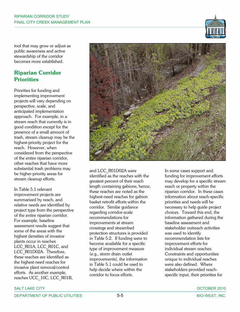
Priorities for funding andimplementing improvementprojects will vary depending onperspective, scale, andanticipated implementationapproach. For example, in astream reach that currently is ingood condition except for thepresence of a small amount oftrash, stream cleanup may be thehighest-priority project for thereach. However, whenconsidered from the perspectiveof the entire riparian corridor,other reaches that have moresubstantial trash problems maybe higher-priority areas forstream cleanup efforts.
In Table 5.1 relevantimprovement projects aresummarized by reach, andrelative needs are identified byproject type from the perspectiveof the entire riparian corridor. For example, baselineassessment results suggest thatsome of the areas with thehighest densities of invasiveplants occur in reachesLCC_R01A, LCC_R01C, andLCC_R01D02A. Therefore,these reaches are identified asthe highest-need reaches forinvasive plant removal/controlefforts. As another example,reaches UCC_10C, LCC_R01B,
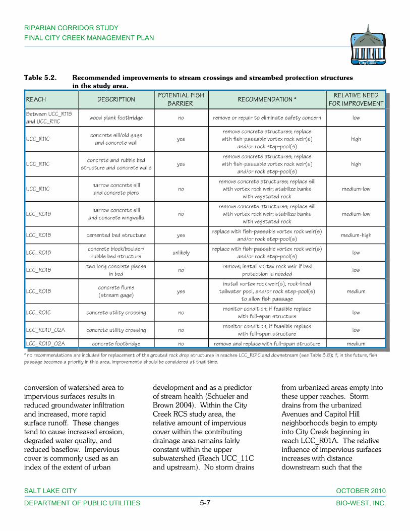
and LCC_R01D02A wereidentified as the reaches with thegreatest percent of their reachlength containing gabions; hence,these reaches are noted as thehighest-need reaches for gabionbasket retrofit efforts within thecorridor. Similar guidanceregarding corridor-scalerecommendations forimprovements at streamcrossings and streambedprotection structures is providedin Table 5.2. If funding were tobecome available for a specifictype of improvement measure(e.g., storm drain outletimprovements), the informationin Table 5.1 could be used tohelp decide where within thecorridor to focus efforts.
In some cases support andfunding for improvement effortsmay develop for a specific streamreach or property within theriparian corridor. In these casesinformation about reach-specificpriorities and needs will benecessary to help guide projectchoices. Toward this end, theinformation gathered during thebaseline assessment andstakeholder outreach activitieswas used to identifyrecommendation lists forimprovement efforts forindividual stream reaches. Constraints and opportunitiesunique to individual reacheswere also defined. Wherestakeholders provided reach-specific input, their priorities for

RIPARIAN CORRIDOR STUDYFINAL CITY CREEK MANAGEMENT PLAN
SALT LAKE CITY OCTOBER 2010
DEPARTMENT OF PUBLIC UTILITIES BIO-WEST, INC.5-6
Table 5.1. Relative need for various improvement measures by study reach. a
REACH NUMBER REACH DESCRIPTION
IMPROVEMENT MEASURE
Str
eam
Cle
anup
- H
and
Mec
hani
zed
Tras
h Re
mov
al
Inva
sive
Pla
nt R
emov
al
Reve
geta
tion
- S
hrub
Reve
geta
tion
-Un
ders
tory
Sto
rm D
rain
/Ru
noff
Impr
ovem
ent
Gab
ion
Bask
et R
etro
fit
Gra
de C
ontr
ol/
Bed
Str
uctu
re P
rote
ctio
n
Slo
pe/B
ank/
Rill
Sta
biliz
atio
n
Acc
ess
Cont
rol/
Trai
l Sta
biliz
atio
n
UCC_R09 Pleasant Valley medium low
UCC_R10A Pipeline low low low low
UCC_R10B Eagles Rest low low low medium
UCC_R10C Water Crest low low high medium
UCC_R11A Elbow Turn low medium medium low low low medium
UCC_R11B Hidden Falls low low low low medium
UCC_R11C Guard Shack Gate Area high medium low low high medium high medium medium
LCC_R01A Below Bonneville Boulevard med medium high medium medium medium medium high high
LCC_R01B Upper Freedom Trail Area med high medium high high high high medium high(gully)
high
LCC_R01C Lower Freedom Trail Area med high high high medium medium low high
LCC_R01D02A Upper Memory Grove Park low low high high high high low high
LCC_R02B Lower Memory Grove Park high medium medium low mediuma Relative needs are identified from the perspective of the entire riparian corridor; e.g., the highest-need reaches for stream cleanup are those assessed as having theworst trash problems in the corridor.
those stream reaches were alsosummarized. This reach-specificinformation is provided inAppendix C. Approximate costestimates for improvementmeasures are provided inAppendix D.
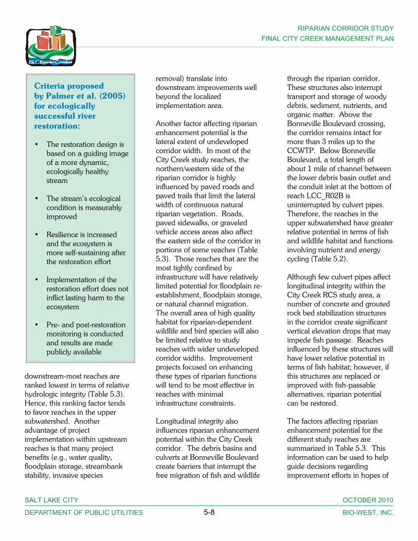
For improvement projects whereecological restoration is theprimary objective, recentlyproposed restoration standards(Palmer et al. 2005) can providesome scientific guidanceregarding project design andprioritization (see sidebar onpage 5-8).
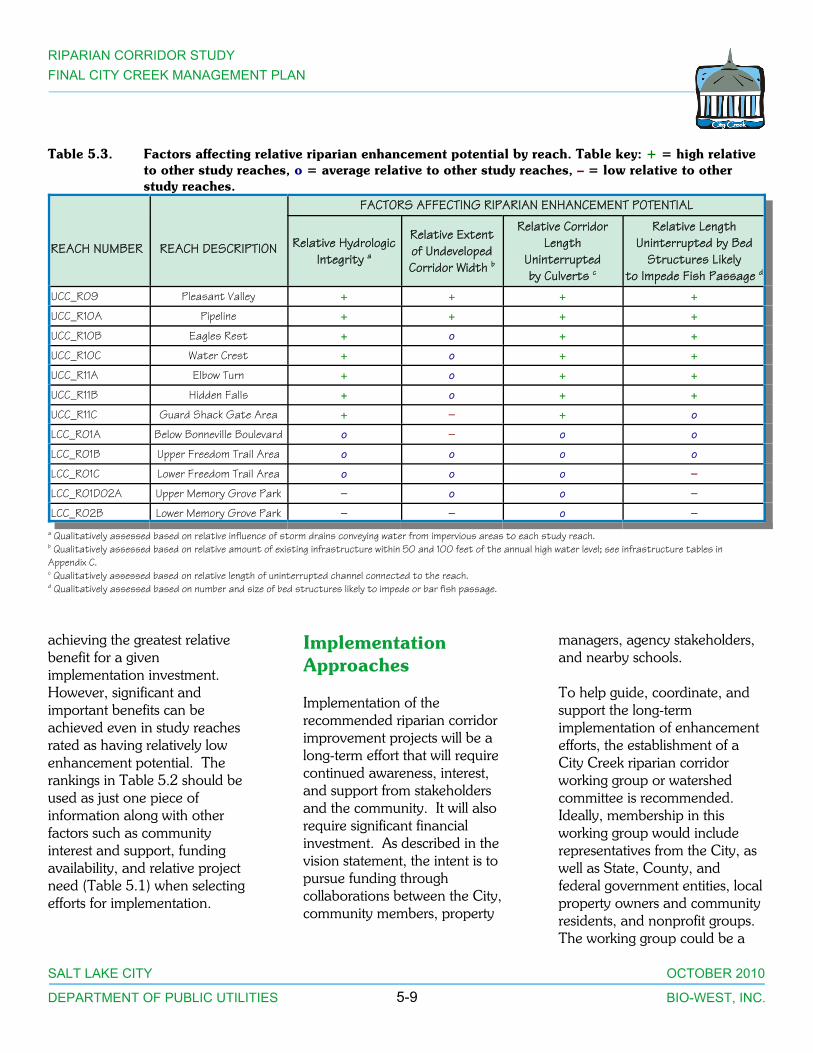
Riparian EnhancementPotential
An important consideration whenselecting projects forimplementation is the potentialfor a given study reach to fullymeet certain riparianenhancement functions orobjectives. This “riparianenhancement potential” variesdepending on the position of thereach in the watershed, theextent of infrastructuredevelopment adjacent to thereach, and the frequency/proximity of road crossings or
other features that interruptlongitudinal connectivity. Projects intended to enhance theriparian functions of wildlifehabitat, floodplain storage, travelcorridors/connectivity, waterquality, or streambank stabilitywill typically be the most effectiveand provide the greatest benefit-to-cost ratio when they areimplemented in reaches withhigh riparian enhancementpotential.
One important factor affectingriparian enhancement potential isimpervious cover percentage. Asdiscussed in Chapter 3, the
RIPARIAN CORRIDOR STUDYFINAL CITY CREEK MANAGEMENT PLAN
SALT LAKE CITY OCTOBER 2010
DEPARTMENT OF PUBLIC UTILITIES BIO-WEST, INC.5-7
Table 5.2. Recommended improvements to stream crossings and streambed protection structuresin the study area.
REACH DESCRIPTION POTENTIAL FISHBARRIER
RECOMMENDATION a RELATIVE NEEDFOR IMPROVEMENT
Between UCC_R11Band UCC_R11C
wood plank footbridge no remove or repair to eliminate safety concern low
UCC_R11Cconcrete sill/old gage
and concrete wall yesremove concrete structures; replacewith fish-passable vortex rock weir(s)
and/or rock step-pool(s)high
UCC_R11Cconcrete and rubble bed
structure and concrete walls yesremove concrete structures; replacewith fish-passable vortex rock weir(s)
and/or rock step-pool(s)high
UCC_R11Cnarrow concrete silland concrete piers no
remove concrete structures; replace sillwith vortex rock weir; stabilize banks
with vegetated rockmedium-low
LCC_R01Bnarrow concrete sill
and concrete wingwalls noremove concrete structures; replace sill
with vortex rock weir; stabilize bankswith vegetated rock
medium-low
LCC_R01B cemented bed structure yes replace with fish-passable vortex rock weir(s)and/or rock step-pool(s)
medium-high
LCC_R01B concrete block/boulder/rubble bed structure
unlikely replace with fish-passable vortex rock weir(s)and/or rock step-pool(s)
low
LCC_R01B two long concrete piecesin bed
no remove; install vortex rock weir if bedprotection is needed
low
LCC_R01Bconcrete flume(stream gage) yes
install vortex rock weir(s), rock-linedtailwater pool, and/or rock step-pool(s)
to allow fish passagemedium
LCC_R01C concrete utility crossing no monitor condition; if feasible replacewith full-span structure
low
LCC_R01D_02A concrete utility crossing no monitor condition; if feasible replacewith full-span structure
low
LCC_R01D_02A concrete footbridge no remove and replace with full-span structure mediuma no recommendations are included for replacement of the grouted rock drop structures in reaches LCC_R01C and downstream (see Table 3.6); if, in the future, fishpassage becomes a priority in this area, improvements should be considered at that time.
conversion of watershed area toimpervious surfaces results inreduced groundwater infiltrationand increased, more rapidsurface runoff. These changestend to cause increased erosion,degraded water quality, andreduced baseflow. Imperviouscover is commonly used as anindex of the extent of urban
development and as a predictorof stream health (Schueler andBrown 2004). Within the CityCreek RCS study area, therelative amount of imperviouscover within the contributingdrainage area remains fairlyconstant within the uppersubwatershed (Reach UCC_11Cand upstream). No storm drains
from urbanized areas empty intothese upper reaches. Stormdrains from the urbanizedAvenues and Capitol Hillneighborhoods begin to emptyinto City Creek beginning inreach LCC_R01A. The relativeinfluence of impervious surfacesincreases with distancedownstream such that the
RIPARIAN CORRIDOR STUDYFINAL CITY CREEK MANAGEMENT PLAN
SALT LAKE CITY OCTOBER 2010
DEPARTMENT OF PUBLIC UTILITIES BIO-WEST, INC.5-8
downstream-most reaches areranked lowest in terms of relativehydrologic integrity (Table 5.3). Hence, this ranking factor tendsto favor reaches in the uppersubwatershed. Anotheradvantage of projectimplementation within upstreamreaches is that many projectbenefits (e.g., water quality,floodplain storage, streambankstability, invasive species
removal) translate intodownstream improvements wellbeyond the localizedimplementation area.
Another factor affecting riparianenhancement potential is thelateral extent of undevelopedcorridor width. In most of theCity Creek study reaches, thenorthern/western side of theriparian corridor is highlyinfluenced by paved roads andpaved trails that limit the lateralwidth of continuous naturalriparian vegetation. Roads,paved sidewalks, or graveledvehicle access areas also affectthe eastern side of the corridor inportions of some reaches (Table5.3). Those reaches that are themost tightly confined byinfrastructure will have relativelylimited potential for floodplain re-establishment, floodplain storage,or natural channel migration. The overall area of high qualityhabitat for riparian-dependentwildlife and bird species will alsobe limited relative to studyreaches with wider undevelopedcorridor widths. Improvementprojects focused on enhancingthese types of riparian functionswill tend to be most effective inreaches with minimalinfrastructure constraints.
Longitudinal integrity alsoinfluences riparian enhancementpotential within the City Creekcorridor. The debris basins andculverts at Bonneville Boulevardcreate barriers that interrupt thefree migration of fish and wildlife
through the riparian corridor. These structures also interrupttransport and storage of woodydebris, sediment, nutrients, andorganic matter. Above theBonneville Boulevard crossing,the corridor remains intact formore than 3 miles up to theCCWTP. Below BonnevilleBoulevard, a total length ofabout 1 mile of channel betweenthe lower debris basin outlet andthe conduit inlet at the bottom ofreach LCC_R02B isuninterrupted by culvert pipes. Therefore, the reaches in theupper subwatershed have greaterrelative potential in terms of fishand wildlife habitat and functionsinvolving nutrient and energycycling (Table 5.2).
Although few culvert pipes affectlongitudinal integrity within theCity Creek RCS study area, anumber of concrete and groutedrock bed stabilization structuresin the corridor create significantvertical elevation drops that mayimpede fish passage. Reachesinfluenced by these structures willhave lower relative potential interms of fish habitat; however, ifthis structures are replaced orimproved with fish-passablealternatives, riparian potentialcan be restored.
The factors affecting riparianenhancement potential for thedifferent study reaches aresummarized in Table 5.3. Thisinformation can be used to helpguide decisions regardingimprovement efforts in hopes of
Criteria proposedby Palmer et al. (2005)for ecologicallysuccessful riverrestoration:
• The restoration design isbased on a guiding imageof a more dynamic,ecologically healthystream
• The stream’s ecologicalcondition is measurablyimproved
• Resilience is increasedand the ecosystem ismore self-sustaining afterthe restoration effort
• Implementation of therestoration effort does notinflict lasting harm to theecosystem
• Pre- and post-restorationmonitoring is conductedand results are madepublicly available
RIPARIAN CORRIDOR STUDYFINAL CITY CREEK MANAGEMENT PLAN
SALT LAKE CITY OCTOBER 2010
DEPARTMENT OF PUBLIC UTILITIES BIO-WEST, INC.5-9
Table 5.3. Factors affecting relative riparian enhancement potential by reach. Table key: + = high relativeto other study reaches, o = average relative to other study reaches, – = low relative to otherstudy reaches.
REACH NUMBER REACH DESCRIPTION
FACTORS AFFECTING RIPARIAN ENHANCEMENT POTENTIAL
Relative HydrologicIntegrity a
Relative Extentof UndevelopedCorridor Width b
Relative CorridorLength
Uninterruptedby Culverts c
Relative LengthUninterrupted by Bed
Structures Likelyto Impede Fish Passage d
UCC_R09 Pleasant Valley + + + +
UCC_R10A Pipeline + + + +
UCC_R10B Eagles Rest + o + +
UCC_R10C Water Crest + o + +
UCC_R11A Elbow Turn + o + +
UCC_R11B Hidden Falls + o + +
UCC_R11C Guard Shack Gate Area + — + o
LCC_R01A Below Bonneville Boulevard o — o o
LCC_R01B Upper Freedom Trail Area o o o o
LCC_R01C Lower Freedom Trail Area o o o —
LCC_R01D02A Upper Memory Grove Park — o o —
LCC_R02B Lower Memory Grove Park — — o —a Qualitatively assessed based on relative influence of storm drains conveying water from impervious areas to each study reach.b Qualitatively assessed based on relative amount of existing infrastructure within 50 and 100 feet of the annual high water level; see infrastructure tables inAppendix C.c Qualitatively assessed based on relative length of uninterrupted channel connected to the reach.d Qualitatively assessed based on number and size of bed structures likely to impede or bar fish passage.
achieving the greatest relativebenefit for a givenimplementation investment. However, significant andimportant benefits can beachieved even in study reachesrated as having relatively lowenhancement potential. Therankings in Table 5.2 should beused as just one piece ofinformation along with otherfactors such as communityinterest and support, fundingavailability, and relative projectneed (Table 5.1) when selectingefforts for implementation.
ImplementationApproaches
Implementation of therecommended riparian corridorimprovement projects will be along-term effort that will requirecontinued awareness, interest,and support from stakeholdersand the community. It will alsorequire significant financialinvestment. As described in thevision statement, the intent is topursue funding throughcollaborations between the City,community members, property
managers, agency stakeholders,and nearby schools.
To help guide, coordinate, andsupport the long-termimplementation of enhancementefforts, the establishment of aCity Creek riparian corridorworking group or watershedcommittee is recommended. Ideally, membership in thisworking group would includerepresentatives from the City, aswell as State, County, andfederal government entities, localproperty owners and communityresidents, and nonprofit groups. The working group could be a
RIPARIAN CORRIDOR STUDYFINAL CITY CREEK MANAGEMENT PLAN
SALT LAKE CITY OCTOBER 2010
DEPARTMENT OF PUBLIC UTILITIES BIO-WEST, INC.5-10
forum for continued involvementby interested members of theexisting RCS Subcommittee andRCS workshop attendees.
One local example of asuccessful “working group”approach to achieving watershedenhancement goals is the EastCanyon Watershed Committee(www.eastcanyoncreek.org). This committee consists of agroup of stakeholders interestedin the health of East CanyonCreek and its watershed. Thegroup has been in existence formore than 10 years and includesrepresentatives from State,County, municipal, and regionalgovernment entities, localproperty owners and communityresidents, nonprofitenvironmental groups, and theSnyderville Basin WaterReclamation District. Thecommittee essentially functionsas an “umbrella” organization tohelp coordinate, facilitate,support, and guide improvementefforts, and also provides aninformation-sharing forum. TheEast Canyon WatershedCommittee has successfullyguided and coordinated a widevariety of watershed and streamimprovement efforts, includingseveral recent streambankstabilization projects. Grantfunds from a number of sources(Nonpoint SourceImplementation [Clean Water ActSection 319] Grant Program,Natural Resources ConservationService (NRCS) Wildlife HabitatIncentive Program, and
Environmental ProtectionAgency Water QualityCooperative Agreement program[Clean Water Act Section 104(b)(3)]) have supported theirefforts. The East CanyonWatershed Committee currentlyincludes education, monitoring,and stream restoration workinggroups that focus on projectsaddressing those specific issues.
Another example of anestablished working group is theJordan River Watershed Council(www.waterresources.slco.org/html/jwrc/jrwc.html). This groupalso consists of a broad mix ofstakeholders, and the JordanRiver Watershed Council hashelped coordinate riparianenhancement efforts along theJordan River. It may be possibleto establish a City Creek-specificsubgroup as a component of thiscouncil. The results of theongoing Jordan River TMDLproject may also spur interest inimprovement projects that wouldprovide water quality benefits.
Certain riparian corridorimprovement efforts could bemodeled on existing partneringapproaches that have provensuccessful. For example, eachspring Salt Lake City partnerswith the Bonneville CooperativeWeed Management Area (CWMA) andenvironmental groups toencourage volunteers toparticipate in weed pulling effortsin the City Creek watershed. This effort has been highly
successful in removing Dyer’swoad from much of the canyon,and past DPU efforts have alsosuccessfully removed saltcedarfrom side drainages. Theseongoing weed control effortscould be expanded to focusspecifically on the invasiveunderstory and tree species thatcurrently pose the greatest threatto native riparian plants. Volunteer revegetation effortscould also be incorporated asappropriate.
During RCS subcommitteemeetings and public workshops,attendees provided suggestionsfor several other types ofimplementation approaches. One suggestion was to involvelocal artists and school childrenin projects, and to emphasizeeducational and interpretiveelements. The idea of a user feeto fund riparian maintenanceactivities was also mentioned.
Other ManagementGuidelines and Efforts
Implementation of the RCSrecommendations will need to beintegrated with other ongoingmanagement efforts andpreviously established guidelineswithin the City Creek corridor. Specific relevant guidelines andprojects are described below.
City Creek Master Plan(SLCC 1986)
In 1986 the City prepared aplanning document to address
RIPARIAN CORRIDOR STUDYFINAL CITY CREEK MANAGEMENT PLAN
SALT LAKE CITY OCTOBER 2010
DEPARTMENT OF PUBLIC UTILITIES BIO-WEST, INC.5-11
land use and circulation issuesfrom the top of City CreekCanyon down to the NorthTemple–State Street intersection. The document recommends thatthe planning policy for CityCreek Canyon above BonnevilleBoulevard emphasizepreservation and limited publicrecreation, while the policy forareas below BonnevilleBoulevard emphasizepreservation of the formalMemory Grove Park to depict theCity’s heritage and serve as a linkbetween the central businessdistrict and the upper canyon. The 1986 plan also recommendsthat areas extending beyond theformally maintained park beretained in their natural state withonly limited improvements toincrease hillside stability,enhance recreation opportunities,and define public/privateproperty boundaries (SLCC1986). These policies appear tobe compatible with the prioritiesproposed in the City Creekriparian corridor visionstatement.
Some relevant specific itemsproposed in the 1986 plan forareas within the RCS study areainclude:
• Retain one lane ofBonneville Boulevardfree of motor vehicletraffic
• Extend the Freedom Trailto Bonneville Boulevard
• Focus on upgrading andmaintaining existingMemory Grove facilitiesrather than constructingnew facilities
• Restore and revegetatehillside cut and fill areas,and prohibit futurehillside cuts/fills
• Monitor landslidepotential and stabilizeareas as necessary
• Provide safe access for alltypes of traffic withoutwidening Canyon Road
• Prohibit residentialdevelopment andcommercial recreation
• Revegetate and stabilizebanks around debrisbasin
• Implement drainageimprovements alongBonneville Boulevard
• Clean up neglected areasby removing abandonedutility poles/wires,concrete chunks, andother debris alongCanyon Road
Salt Lake City WatershedManagement Plan (BearWest 1999)
This document updates anoriginal 1988 plan developed toprotect the seven major WasatchMountain canyons east of Salt
Lake Valley, including CityCreek, that serve as majormunicipal water sources. The1999 plan includes a desiredfuture condition statement thatemphasizes maintenance ofexcellent water quality andprioritizes water quality first andother canyon uses second. Otherelements of the desired futurecondition include healthy streamsand riparian areas, ecologicalbalance, and minimal pollution. The 1999 plan emphasizes theuse of a watershed educationprogram to help limit potentialdegradation associated withrecreational use of the canyons. It also recommends exploringalternative funding sources forCity Creek such as a user-feebooth or annual pass program.
City Creek Shaded FuelBreak Project
In 2006 concerns about thepotential for wildfire in CityCreek Canyon prompted theU.S. Forest Service to conduct afuels load assessment of the area. The assessment found that fuelaccumulations and loads werehigh, and recommended severaldifferent fuel reductiontreatments for different parts ofthe canyon (Corbin et al. 2007). As its highest priority, the studyrecommended that a shaded fuelbreak be implemented along theroadway corridor to reduce brushdensity and ensure safe accessand evacuation routes for firefighters and public users of thecanyon.
RIPARIAN CORRIDOR STUDYFINAL CITY CREEK MANAGEMENT PLAN
SALT LAKE CITY OCTOBER 2010
DEPARTMENT OF PUBLIC UTILITIES BIO-WEST, INC.5-12
In 2009 and 2010, the City heldseveral public meetings about theidea of a shaded fuel break andestablished a Citizen’s ReviewCommittee to ensure thatconcerns about potential impactsto the visual, recreation, plant,and wildlife resources of the areawere addressed. Three test plotshave been proposed forimplementation in fall 2010, anddetailed baseline monitoring ofvegetation and bird communitiesat these sites has beencompleted. The shaded fuelbreak technique entailsselectively thinning vegetation toreduce fuel loads, while retaininglarge trees and a shaded canopy. Efforts will be limited to the northside of the City Creek CanyonRoad; springs and riparian areason the south (stream) side of theroad will not be affected, and noconflicts with therecommendations of the RCS areanticipated. More informationon the shaded fuel break projectcan be found at: http://www.slcgov.com/Utilities/firesuppression.htm.
Action Items
A variety of specific action itemsare recommended forimplementation. These items aregrouped by overall goal andlisted below. Following theadoption of a working group orother organizational framework,more detailed project prioritieswill be determined, allowing fordevelopment of fundingapproaches and grant
applications. The DPU willinclude riparian corridor projectsin annual budgets based onavailable funding and systemneeds, and by referring to theprioritized lists in this document. Priorities established in this CityCreek study will be included,along with priorities on otherstreams, to provide direction forCity project implementation. Tothe extent possible, DPU’simplementation efforts will bebalanced among all four of theCity’s creeks (City, Red Butte,Emigration, and Parleys) and theJordan River.
Goal: Continue PublicOutreach and EstablishImplementation WorkingGroup
• establish organizationalstructure to guideimplementation ofriparian corridorimprovement efforts
• promote involvement ofmultiple agencies/organizations in workinggroup to facilitatecommunication regardingproject ideas andpotential funding sources(e.g., schools with needsfor volunteer projects,U.S. Army Corps ofEngineers in-lieumitigation funds, etc.)
• encourage community/school groups, residents,and local businesses toparticipate in the Utah“Adopt a Waterbody”program
• encourage communitymembers to participate incitizen water qualitymonitoring incoordination with theUtah Department ofEnvironmental Quality’sstatewide MonitoringCouncil
RIPARIAN CORRIDOR STUDYFINAL CITY CREEK MANAGEMENT PLAN
SALT LAKE CITY OCTOBER 2010
DEPARTMENT OF PUBLIC UTILITIES BIO-WEST, INC.5-13
• partner with the existingFriends of City CreekCanyon group to supportand expand theirongoing Memory Grovetrash cleanup andvolunteer weed pullefforts
Goal: Increase PublicAwareness
• stencil storm drain inletsusing lettering thatincludes stream names(e.g., “Do not dump:drains to City Creek”);coordinate this effort withthe established Salt LakeCounty StormwaterCoalition
• prepare informationalinsert to distribute inutility bills; insert shouldinclude a map of streamcorridors and publicaccess points andinformation on ripariancorridor functions andthe RCS process
• conduct a ripariancorridor-focused activityduring the City’sestablished annual“Water Week” event
Goal: Manage and ReduceImpervious Surfaces
• protect existingundeveloped lowersubwatershed areasthrough pursuit of openspace and conservationeasement acquisitionsand/or appropriate re-zoning efforts
• promote/require use ofprogressive long-termstormwater BMPs thatreduce the hydrologicimpacts of newdevelopments;coordinate this effort withthe Salt Lake CityDivision of Sustainabilityand Environment
• coordinate and partnerwith existingorganizations involvedwith storm watermanagement
• work with internal Citymanagement andmaintenance entities(roads, parks, watershed,water treatment divisions)to ensure progressivestorm water BMPs arefollowed
Goal: Improve RiparianCorridor Aesthetics
• promote volunteerstream cleanups

RIPARIAN CORRIDOR STUDYFINAL CITY CREEK MANAGEMENT PLAN
SALT LAKE CITY OCTOBER 2010
DEPARTMENT OF PUBLIC UTILITIES BIO-WEST, INC.5-14
• remove over-sized trashitems from publiclyowned riparian corridorareas
Goal: Improve RiparianHabitat through Controlof Invasive Plant Speciesand Restoration of NativePlant Communities
• promote invasive plantremoval by targeting andpublicizing one high-priority species per year
• initiate invasive plantremoval/control effortsbeginning upstream andworking downstream,utilizing an integratedweed control strategy
• ensure continued internalcompliance with BMPs toreduce transfer of weedseeds such as washingtires/treads when vehiclesand equipment aremoved between areas;encourage use of similarpractices by Salt LakeCounty and the UtahDepartment ofTransportation
• ensure funding and laborwill be available for multi-year follow-up treatmentsand long-termmaintenance/monitoringof revegetated areas
Goal: Improve RiparianFunctionsthrough Improvementsto Storm Drain and StreamCrossing Infrastructure
• budget for andimplement identifiedimprovements at streamcrossings and streambedhardening structures
• budget for andimplement identifiedstorm drain outfallimprovement projects
The City Creek riparian corridorcurrently provides a wealth ofriparian functions andcommunity benefits. Manyopportunities exist to enhancethese functions and benefits. With dedication on the part of allstakeholders, the vision for thecorridor can be achieved.