Embed Size (px)
Citation preview
E A S T C L A Y T O N N E I G H B O U R H O O D C O N C E P T P L A N , 2000
EA
ST
CL
AY
TO
N N
CP
7070707070
5.0 ECOLOGICAL INFRASTRUCTUREPERFORMANCE STANDARDS ANDGUIDELINES
The green infrastructure performance standards and guidelines suggest the necessary minimum levels ofperformance for maintaining and potentially enhancing natural drainage systems in East Clayton. Thissection describes how the principles of infiltration best management practices (BMPs), urban forestry, andsoil preservation should be applied to building sites, streets, and public green spaces.
Objectives
• to reduce immediate as well as life cycle costs of the storm drainage system;• to protect and enhance the environment;• to increase access to, and variety of, recreational opportunities;• to protect habitat, especially fish habitat;• to maintain stream hydrology and stream water quality;• to eliminate the need for removing any soil from the site; and• to enhance community value, quality, and appeal.
5.1 Building Sites – Performance Objectives
• All lots are to be constructed so as to minimize impervious surfaces.• For areas with gross residential densities of equal to or less than 20 dwelling units per
acre, no more than 45 percent of the site is to be covered with impermeable surfaces(roofs and impermeable pavement). Remaining permeable areas are to accept roofrunoff, patio runoff, and so on; they are to be equipped with infiltration devices (orinfiltration grading) capable of enhancing the infiltration capacity of the site, which isto function as though it had no impermeable surfaces and as though it were vegetatedand uncompacted.
• The Business Park area, Specialty Commercial area, and the 196th Street Mixed-useCommercial area are to accommodate the rainfall from the 6 month storm through theincorporation of detention and infiltration systems. (See Figure 5.1.3Figure 5.1.3Figure 5.1.3Figure 5.1.3Figure 5.1.3 and Section5.3.1.1 in addition to Section 6.0 for details).
• All surface parking areas (e.g., Specialty Commercial and Techno-business Park),shall be planted with trees at a minimum of one tree per every 5 spaces. Tree specieswith a canopy large enough to cover, at tree maturity, a minimum of 50 percent ofeach parking surface shall be chosen by the Parks Department.
• Performance thresholds for sites are, therefore, 24 millimetres (0.9 inches) per day, onaverage, during winter conditions, times the total area of the parcel.
5.1.1. Infiltration Best Management Practices for Building Sites
• Infiltration enhancements can be accomplished via infiltration pits of various designs andconfiguration.
• In most cases infiltration pits should be located at front, rear, or side property linesand as far from building foundations as is practical so that there is at least one metre(3 feet) of undisturbed parent material between infiltration pits and foundationexcavation. Infiltration pits should be filled with three-quarter-inch crushed rock orprefabricated infiltrators.

E A S T C L A Y T O N N E I G H B O U R H O O D C O N C E P T P L A N , 2000
5.0
EC
OL
OG
ICA
L IN
FR
AS
TR
UC
TU
RE
7171717171
• Grass filter strips and elevated yard drain inlets are to be used to prevent siltation.Observation pipes must be installed in each pit/trench. Roof drains are to dischargeinto lawn or planted areas rather than directly into infiltration devices to allow siltsand organic matter emanating from the roof to be absorbed by surface vegetation.
• In general, infiltration devices are to be designed to ensure at least 30 years of trouble-free operation under normal use. Siltation is the most common reason for infiltrationdevice failure; consequently extreme care is to be exercised in designing and installingsystems.The Engineering Department will inspect and approve all constructionspecifications for infiltration devices and will observe their installation. In certaininstances infiltration objectives may be met not by installing infiltration pits, but bycareful yard grading and installating of deeply mulched planting areas. Plants shouldbe chosen for their water tolerance.
5.1.2. Urban Forestry on Building Sites
• Residential yards are an important element in the urban forestry strategy for EastClayton. In the permeable areas of the lot, locations should be found for shade treesso that, when mature, their canopy will cover at least 40 percent of the lot. Trees willgenerally be of the “medium-sized” variety, capable of achieving approximately 12metres (40 feet) in height, and a comparable breadth, at maturity. A list of suggested nativespecies is available from the Surrey Parks, Recreation and Culture Department.
• Trees are to be located at least 3 metres (10 feet) from the outside edge of infiltrationdevices. Trees should be at least 3 inches (7.62 centimetres) diamtere at breast height(d.b.h.) when installed, and they should be thriving one year after planting.
5.1.3 Soil Preservation on Building Sites
• Site topsoil is to be carefully stockpiled for later redistribution on the site. In no casesshould topsoil be removed from the site. Stockpiled topsoil is to be examined by theEngineering Department to ensure that there is no loss or removal of this resource. Ingeneral, on sites developed for residential use at densities at or lower than 25 units peracre, the area available for re-spreading this topsoil will be approximately 50 percentof the area of the site prior to development. Consequently, topsoil depths in thefinished site will be up to twice what they were originally.
• Topsoil depth in East Clayton is generally thin, often less than 0.5 metre (1.6 feet).Where topsoil depth is greater than 0.5 metre, at least the first 0.5 metre of topsoilshould be stockpiled for later distribution over the areas intended for permeablesurfaces. This requirement ensures that the thin soils of the Clayton area are re-used totheir maximum advantage and that topsoil will not be permanently removed from thesite. In short, yards and boulevards must absorb more water and provide a better mediumfor tree growth when development projects are completed than they do at present.
• Care must be exercised in grading the site and setting finished floor elevations.This sitedevelopment method will make it difficult (and in many cases impossible) to retainexisting trees. In these cases the need to ensure the adequate hydrological and urbanforestry performance of the site after development will take priority.
• Proper aeration of returned topsoil is crucial. Topsoil areas are to be checked for depthand aeration prior to the granting of an occupancy permit by the Surrey EngineeringBuilding Departments. Soil amendments may also be required. Pre-existing vegetationmay need to be ground up and added to the soil to improve its aeration and humus
E A S T C L A Y T O N N E I G H B O U R H O O D C O N C E P T P L A N , 2000
EA
ST
CL
AY
TO
N N
CP
7272727272
content. If this process leaves soil that is still too thin for healthy tree growth and waterinfiltration, then additional soil amendments will be called for.
• In keeping with its regulations, the Surrey Parks Department will review and approvesoil tests and any proposed amendment strategy. It will also inspect construction sitesto ensure compliance.
5.1.4 Foundation Drains
• Foundations can be drained in three basic ways. Acceptable devices include electricsump pumps that can be run from municipal water pressure in the event of electricpower failure (these pumps should discharge into yards in the same manner asdownspouts); drain pipes that discharge into street-side infiltration devices, street-sideswales, or lanes; and a street “storm-drain” system that connects into the district systemof infiltration wells or retention ponds.
• A foundation drain strategy can be chosen, as cost and site constraints dictate, by thedeveloper (with the approval of the City Engineer).
5.2 Streets – Performance Objectives
• All residential lots are to be constructed to maximize the retention of permeable surfaces.• Generally, street rights-of-ways are to be no more than 50 percent impermeable
surfaces. Remaining permeable areas are to accept runoff from paved areas and are tobe equipped with infiltration devices capable of enhancing the infiltration capacity, sothat, under average precipitation conditions, the site will perform as though it had noimpermeable surfaces and as though it were vegetated and uncompacted.
• Infiltration performance threshold for streets would, therefore, be 24 millimetres (0.9inches) per day, on average, during winter conditions, times the total area of the rightof-way.
5.2.1 Infiltration Best Management Practices (BMPs) for Streets
• In most cases infiltration devices will be located on one side of local streets. In certaincases, infiltration devices will be located on both sides of collector streets and arterials.Refer to Section 8.0 for more detailed street design information. Grass filter strips andelevated drain inlets, or other similar devices approved by the Surrey EngineeringDepartment, must be used to prevent siltation. Observation pipes must be installed ineach device.
• In general, infiltration devices are to be designed to insure at least 30 years of troublefree operation under normal use. Siltation is the most common reason for infiltrationdevice failure; consequently, extreme care should be exercised in designing thesesystems. Approved filter fabric must be used to line rock-filled trenches. The SurreyEngineering Department will inspect and approve all construction specifications forinfiltration devices and will observe their installation. In certain instances infiltrationobjectives may be met in part or in whole by using permeable pavement with aninfiltration capacity equal to or exceeding 24 millimetres (0.9 inches) per day duringwinter conditions.
• Certain portions of East Clayton are suitable for deep well infiltration thereby allowingfor aquifer recharge. These systems are capable of handling a five-year storm. Detailsof these areas and design parameters for deep well infiltrators can be found in Section
E A S T C L A Y T O N N E I G H B O U R H O O D C O N C E P T P L A N , 2000
5.0
EC
OL
OG
ICA
L IN
FR
AS
TR
UC
TU
RE
7373737373
6.0 of this report. Specific system design is to be managed on a development-bydevelopment basis under the direction of the Surrey Engineering Department.
• Subsurface conveyance systems are required to deliver water in excess of 24millimetres (0.9 inches) per day during winter conditions up to the five-year stormamount. A typical device is a shallow perforated pipe located near the top of street-sideinfiltration devices. Such pipes connect all infiltration devices on the street and deliverwater to secondary retention and treatment ponds/artificial wetlands that, in most cases,are located on public lands. Storms in excess of the five-year event are conveyed overthe surface, via the right-of-way to the aforementioned treatment ponds/artificialwetlands.
• Curbs that prevent the free flow of water from paved surfaces to grass boulevards arenot allowed. On curbless streets, the spaces between pavement edge and turf boulevardmust allow for the free flow of water. Soil level at pavement edge must be between twoand three inches below pavement level in order to prevent water damming by the turf.
• Bollards, or other devices for discouraging parking on turf, are required. Suggesteddevices include concrete or natural stone “bollards” or occasional barriers locatedapproximately every 3 metres (10 feet). These devices are not to impede pedestrianmovement from sidewalk to street, nor are they to interfere with car doors.
• Modified rolled curb edges with water inlets located at no more than 1.5 metres (5 feet)intervals may also be allowed.
5.2.3 Urban Forestry on Street Rights-of-ways
• Streets are an important element in the urban forestry strategy for East Clayton.Locations are to be found in the permeable areas of the right of way for shade trees.When mature, the canopy of these trees will cover at least 60 percent of the street.Trees will generally be of the “medium-sized” variety, capable of achieving a height ofapproximately 12 metres (40 feet), and a comparable breadth, at maturity. (A list ofsuggested species is available from the City of Surrey Parks, Recreation and CultureDepartment.
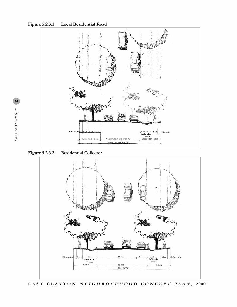
• The Surrey Parks, Recreation and Culture Department should be consulted withregard to tree spacing and species variety. Trees are to be located such that theinfiltration device does not cause detrimental impact to the tree roots. Paved sidewalkswithin 3 metres (10 feet) of a tree trunk should be underlain with structural soil toavoid sidewalk heaving. Trees should be at least 7.6 centimetres (3 inches) diameter atbreast height when installed and should be thriving one year after planting (seeFigures 5.2.3.1– 5.2.3.4Figures 5.2.3.1– 5.2.3.4Figures 5.2.3.1– 5.2.3.4Figures 5.2.3.1– 5.2.3.4Figures 5.2.3.1– 5.2.3.4).
5.2.4 Soil Preservation on Street Rights-of-Ways
• Site topsoil must be carefully stockpiled for later redistribution on the right-of-way. Inno cases should topsoil be removed from the site. The Surrey engineering departmentwill examine stockpiled topsoil to ensure there is no loss of this resource. Generally,the area available in street rights-of-way for re-spreading this topsoil will beapproximately 50 percent of the area of the right of way prior to development.Consequently, topsoil depths in the finished site will be up to twice what they wereoriginally.
• Topsoil depth in East Clayton is generally thin, often less than 0.5 metre (1.6 feet).Topsoil excavated for replacement by structural gravel is to be stockpiled on the site for
E A S T C L A Y T O N N E I G H B O U R H O O D C O N C E P T P L A N , 2000
EA
ST
CL
AY
TO
N N
CP
7474747474
Figure 5.2.3.1 Local Residential Road
Figure 5.2.3.2 Residential Collector

E A S T C L A Y T O N N E I G H B O U R H O O D C O N C E P T P L A N , 2000
5.0
EC
OL
OG
ICA
L IN
FR
AS
TR
UC
TU
RE
7575757575
Figure 5.2.3.3 Green Arterial
Figure 5.2.3.4 Residential Lane
E A S T C L A Y T O N N E I G H B O U R H O O D C O N C E P T P L A N , 2000
EA
ST
CL
AY
TO
N N
CP
7676767676
later distribution over the areas of the right-of-way intended for permeable surfaces (i.e.,boulevards).
• Care must be exercised in grading the site and setting final street grades to ensure thatthis happens. This site development method will make it difficult (and in many casesimpossible) to retain existing trees. In these cases the need to ensure that adequatehydrological and urban forestry performance of the site after development will takepriority.
• Proper aeration of returned topsoil is crucial. Topsoil areas will be checked for depthand aeration prior to the granting of an occupancy permit by Surrey Engineering/BuildingDepartment. Pre-existing vegetation on the site may need to be ground up and added tothe soil to improve aeration and humus content. If this process still leaves soilunsuitable, then additional soil amendments will be called for.The Surrey ParksDepartment will review soil tests and proposed amendment strategy.
5.3 Public and Natural Areas
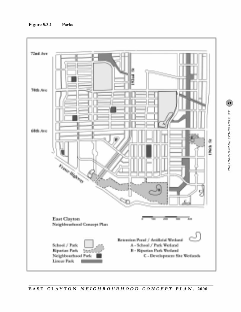
These guidelines are applicable to the various components of the public green space network that extendsthroughout East Clayton. TTTTTable 5.3.1able 5.3.1able 5.3.1able 5.3.1able 5.3.1 indicates the areas allocated, and Figure 5.3.1Figure 5.3.1Figure 5.3.1Figure 5.3.1Figure 5.3.1 shows the location ofvarious components of the network. The network serves both ecological and social purposes by supportingthe surface drainage system, providing sufficient avian and aquatic habitat, maintaining base flows instreams, and providing areas for both passive and active recreation.
5.3.1 School/Park Sites
The plan proposes 9.53 hectares (23.54 acres) of combined park and school sites. Each of the sites is toserve the recreation and educational needs of the community. Areas of forest cover, combined with anaturalized wetland/retention pond on the eastern school/park site, are to provide infiltration for surfacewater and bird habitat. The Surrey Parks Department will manage and oversee construction andmaintenance of the school/park sites.
5.3.1.1 Infiltration Best Management Practices (BMPs) and Wetlands
• All impervious surfaces (i.e., multi-use paths, streets, parking lots) are to drain intopermeable areas and/or on-site infiltration devices.
• All permeable surfaces on park/school sites are required to infiltrate at rates not lessthan 36 millimteres (1.4 inches) per day during winter conditions.
• Where required, infiltration BMPs and soil preservation measures (as per sections 5.2.1and 5.2.3) are to be applied in order to achieve prescribed infiltration rates.
Table 5.3. 1 Public and Natural Areas
Public and Natural Areas Ha. Acres School/Park Sites 9.53 23.54
Storm Water Pond (Public property) 4.48 11.05
Storm Water Pond (Private property) 1.14 2.81
Riparian Protection Area 6.70 16.55
Parks and Linear Open Space 14.45 35.71
Private lawns along arterials (buffers) 0.86 2.12
Natural Area (adjacent to Riparian Greenway) 1.84 4.54
Utility Open Space 0.64 1.58
Total 39.64 97.9
E A S T C L A Y T O N N E I G H B O U R H O O D C O N C E P T P L A N , 2000
5.0
EC
OL
OG
ICA
L IN
FR
AS
TR
UC
TU
RE
7777777777
Figure 5.3.1 Parks
E A S T C L A Y T O N N E I G H B O U R H O O D C O N C E P T P L A N , 2000
EA
ST
CL
AY
TO
N N
CP
7878787878
The wetland proposed for the schoolground in the northeastern quadrant of the site is intended as aretention and biofiltration area for surface water. The wetland is to incorporate a naturalized edge withnative wetland plants and to provide small islands and protected areas for bird habitat.
• The centre depth is to be no greater than 1 metre (3.3 feet) with peripheral areasaccepting the five-year storm and remaining marginally wet. The 100-year storm willflood adjacent sports fields up to a maximum depth of 1 metre (3.3 feet).
• All such work is to comply with existing Surrey Parks, Recreation, and CultureDepartment construction and maintenance standards and guidelines and be inspected bythe Surrey Engineering Department and Ministry of Environment, Lands and Parksstaff. All detained water is to be discharged into streams only as per Department ofFisheries and Oceans and Ministry of Environment, Lands and Parks regulations.
5.3.1.2 Urban Forestry
• At least 40 percent of school/park sites are to be covered by canopy at tree maturity.• Areas that are not required for playfields shall have up to 50 percent habitat value in order
to replace habitat lost to construction. There is to be a particular emphasis on avian habitat.
5.3.2 Riparian Parks
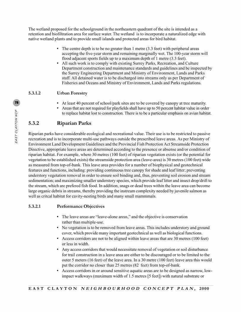
Riparian parks have considerable ecological and recreational value. Their use is to be restricted to passiverecreation and is to incorporate multi-use pathways outside the prescribed leave areas. As per Ministry ofEnvironment Land Development Guidelines and the Provincial Fish Protection Act Streamside ProtectionDirective, appropriate leave areas are determined according to the presence or absense and/or condition ofriparian habitat. For example, where 30 metres (100 feet) of riparian vegetation exists (or the potential forvegetation to be established exists) the streamside protection area (leave-area) is 30 metres (100 feet) wideas measured from top-of-bank. This leave area provides for a number of biophysical and geotechnicalfeatures and functions, including: providing continuous tree canopy for shade and leaf litter; preventingunderstory vegetation removal in order to ensure soil binding and, thus, preventing soil erosion and streamsedimentation; and maximizing smaller understory species, which provide leaf litter and insect drop/drift tothe stream, which are prefered fish food. In addition, snags or dead trees within the leave area can becomelarge organic debris in streams, thereby providing the instream complexity needed by juvenile salmon aswell as critcal habitat for cavity-nesting birds and many small mammmals.
5.3.2.1 Performance Objectives
• The leave areas are “leave-alone areas,” and the objective is conservationrather than multiple-use.
• No vegetation is to be removed from leave areas. This includes understory and groundcover, which provide many important geotechnical as well as biological functions.
• Access corridors are not to be aligned within leave areas that are 30 metres (100 feet)or less in width.
• Any access corridors that would necessitate removal of vegetation or soil disturbancefor trail construction in a leave area are either to be discouraged or to be limited to theouter 5 meters (16 feet) of the leave area. In a 30 metre (100 feet) leave area this wouldput the corridor no closer than 25 metres (82 feet) from top-of-bank.
• Access corridors in or around sensitive aquatic areas are to be designed as narrow, low-impact walkways (maximum width of 1.5 metres [5 feet]) with natural substrate or
E A S T C L A Y T O N N E I G H B O U R H O O D C O N C E P T P L A N , 2000
5.0
EC
OL
OG
ICA
L IN
FR
AS
TR
UC
TU
RE
7979797979crushed gravel surfaces to encourage infiltration (asphalt, compacted clay, or barkmulch are not permitted). Access corridors within the leave areas are not to be designedto accommodate vehicles (including wheelchairs and bicycles). Hard surface multi-usepaths outside the leave area can accommodate vehicles (i.e., wheelchairs and bicycles)and are to be a maximum of 4 metres (13 feet).
• Where it can be accommodated by meandering through existing vegetation or byremoving limited vegetation and disturbing very little of the surface soils a narrowfootpath (maximum width 1.2 metres [4 feet]) could be used either to connect thecorridor on one side of the leave area to a particular site of interest within the leave areaor to transect the leave area altogether. Such footpaths should be aligned at right anglesto the stream so that it limits the length of the incursion within the leave area. So as toavoid wetted or erodible areas or areas supporting unique or sensitive vegetation thelocations for these penetrating footpaths are to be developed following a thoroughassessment of the area. Alternatively, these narrow access footpaths should be elevatedabove the forest floor (i.e., on boardwalks), with associated signage explaining thebiological values of these areas.
5.3.2.2 Artificial Wetlands/Retention Ponds
The Land-Use Plan proposes situating two artificial wetlands adjacent to riparian park areas: the first is to belocated near the headwaters of McClellan Creek, and the second is to be located just north of the NorthCloverdale Stream riparian zone.
• Retention ponds shall be located outside the leave areas.• The stormwater management ponds are to be designed to limit flows to the creeks to
existing rates for 2-year through to the 100-year return period storms.• Where required, infiltration BMPs and soil preservation measures, as per Sections 5.2.1 and
5.2.3, are to be applied so as to achieve prescribed infiltration rates.• All work is to comply with existing Surrey Parks, Recreation and Culture Department
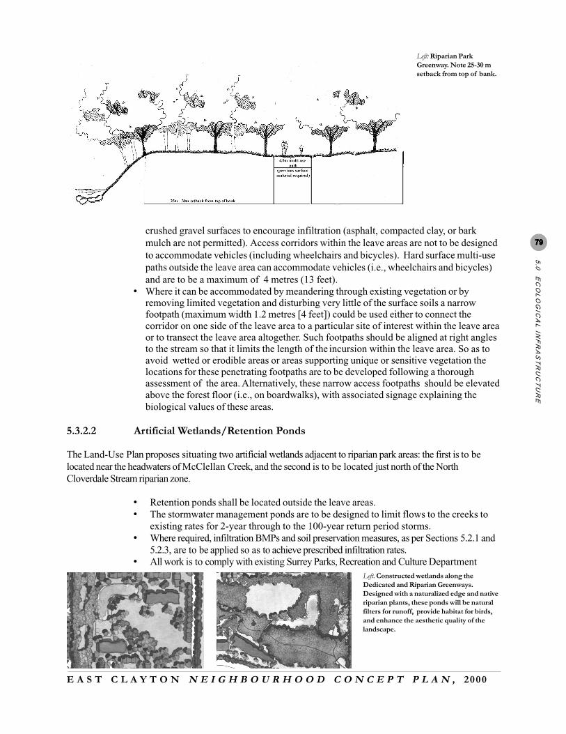
Left. Constructed wetlands along theDedicated and Riparian Greenways.Designed with a naturalized edge and nativeriparian plants, these ponds will be naturalfilters for runoff, provide habitat for birds,and enhance the aesthetic quality of thelandscape.
Left: Riparian ParkGreenway. Note 25-30 msetback from top of bank.

E A S T C L A Y T O N N E I G H B O U R H O O D C O N C E P T P L A N , 2000
EA
ST
CL
AY
TO
N N
CP
8080808080
construction and maintenance standards and guidelines, and it is to be inspected by theSurrey Engineering Department and the Ministry of Environment, Lands and Parks staff.
• The centre depth of the retention pond/artificial wetland is to be no greater than 1 metre (3.3feet) with peripheral areas accepting the five-year storm and remaining marginally wet. The100-year storm will flood adjacent sports fields up to a maximum depth of 1 metre (3.3 feet).
• Ponds should be designed for maximum practical water retention to further improvewater quality. The design must also reduce possible temperature impact.
• The wetlands are to incorporate a naturalized edge with native wetland plants and to providesmall islands and protected areas for bird habitat.
• All detained water is to be discharged into streams at discharge rates and of a quality thatconforms with Department of Fisheries and Oceans and Ministry of Environment, Lands anParks regulations.
5.3.2.3 Urban Forestry
• All existing forested areas are to be maintained for infiltration (i.e., the understory andnatural mulching of the forest is to be preserved).
• All riparian setbacks (up to 30 metres [100 feet]) or as much as possible given naturalspecies composition, shall be maintained as large woody vegetation (preferably largetrees that with overstory for angular canopy cover).
• Each riparian area is to accommodate open clearings for recreation outside the prescribedleave area. This area will be available for holding flood waters for the 100-year storm up toa maximum depth of 1 metre (3.3 feet.).
• The Surrey Parks Department, in co-operation with the Surrey Engineering Department, is tomanage and oversee the construction and maintenance of riparian parks.
5.3.3 Neighbourhood Parks
5.3.3.1 Infiltration
• All impermeable surfaces (i.e., multi-use paths, streets) are to drain into permeable areas and/or on-site infiltration devices.
• All permeable surfaces are required to infiltrate at rates of not less than 36 millimetres (1.4inches) per day during winter conditions.
• Where required, infiltration BMPs and soil preservation measures, as per Sections 5.2.1 and5.2.3, are to be applied in order to achieve prescribed infiltration rates.
• Neighbourhood parks are to accept and to manage drainage from surrounding street surfaces,and, in certain instances, they are to provide locations for deep well infiltrators.
• Pathways and sidewalks around the periphery of parks are to drain into permeable areas andor into infiltration devices.
5.3.3.2 Urban Forestry
• At least 30 percent of neighbourhood parks are to be covered by canopy at treematurity, thus ensuring that a strong vegetated edge surrounds an open interior space.
• The Surrey Parks Department is to manage and oversee the construction andmaintenance of all public parks.
5.3.4 Greenways and Bicycle Routes
The East Clayton greenway system is a series of multi-use corridors that are to connect areas of public and
E A S T C L A Y T O N N E I G H B O U R H O O D C O N C E P T P L A N , 2000
5.0
EC
OL
OG
ICA
L IN
FR
AS
TR
UC
TU
RE
8181818181
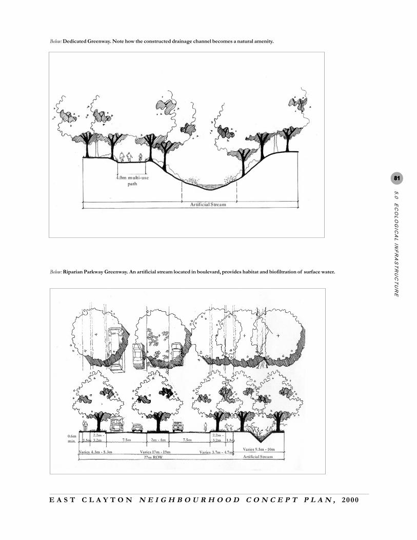
Below: Dedicated Greenway. Note how the constructed drainage channel becomes a natural amenity.
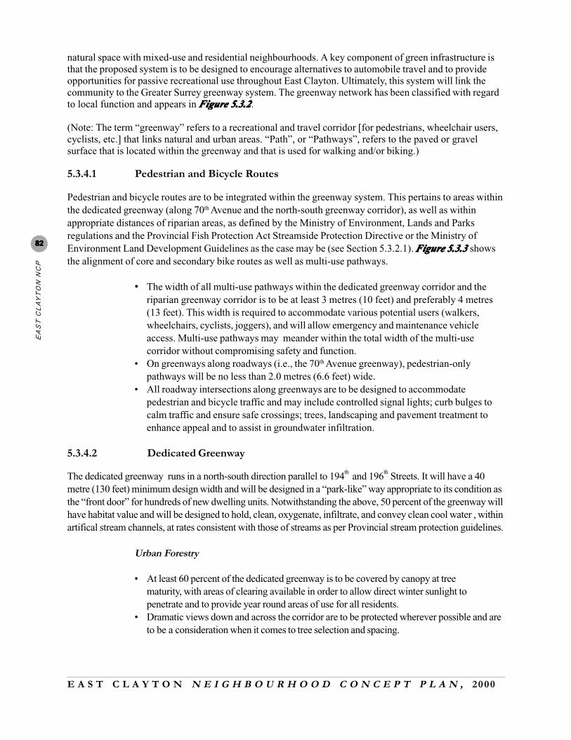
Below: Riparian Parkway Greenway. An artificial stream located in boulevard, provides habitat and biofiltration of surface water.
E A S T C L A Y T O N N E I G H B O U R H O O D C O N C E P T P L A N , 2000
EA
ST
CL
AY
TO
N N
CP
8282828282
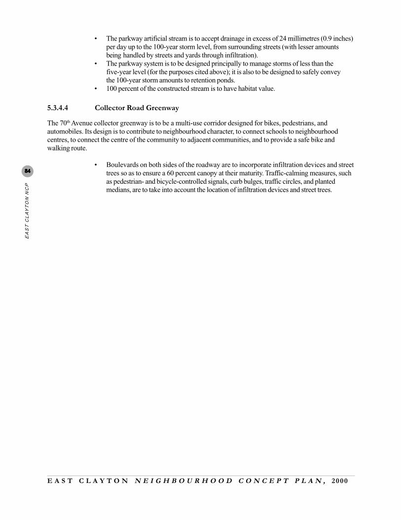
natural space with mixed-use and residential neighbourhoods. A key component of green infrastructure isthat the proposed system is to be designed to encourage alternatives to automobile travel and to provideopportunities for passive recreational use throughout East Clayton. Ultimately, this system will link thecommunity to the Greater Surrey greenway system. The greenway network has been classified with regardto local function and appears in Figure 5.3.2Figure 5.3.2Figure 5.3.2Figure 5.3.2Figure 5.3.2.
(Note: The term “greenway” refers to a recreational and travel corridor [for pedestrians, wheelchair users,cyclists, etc.] that links natural and urban areas. “Path”, or “Pathways”, refers to the paved or gravelsurface that is located within the greenway and that is used for walking and/or biking.)
5.3.4.1 Pedestrian and Bicycle Routes
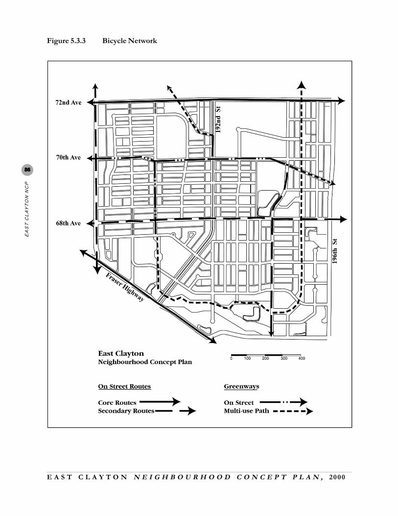
Pedestrian and bicycle routes are to be integrated within the greenway system. This pertains to areas withinthe dedicated greenway (along 70th Avenue and the north-south greenway corridor), as well as withinappropriate distances of riparian areas, as defined by the Ministry of Environment, Lands and Parksregulations and the Provincial Fish Protection Act Streamside Protection Directive or the Ministry ofEnvironment Land Development Guidelines as the case may be (see Section 5.3.2.1). Figure 5.3.3Figure 5.3.3Figure 5.3.3Figure 5.3.3Figure 5.3.3 showsthe alignment of core and secondary bike routes as well as multi-use pathways.
• The width of all multi-use pathways within the dedicated greenway corridor and theriparian greenway corridor is to be at least 3 metres (10 feet) and preferably 4 metres(13 feet). This width is required to accommodate various potential users (walkers,wheelchairs, cyclists, joggers), and will allow emergency and maintenance vehicleaccess. Multi-use pathways may meander within the total width of the multi-usecorridor without compromising safety and function.
• On greenways along roadways (i.e., the 70th Avenue greenway), pedestrian-onlypathways will be no less than 2.0 metres (6.6 feet) wide.
• All roadway intersections along greenways are to be designed to accommodatepedestrian and bicycle traffic and may include controlled signal lights; curb bulges tocalm traffic and ensure safe crossings; trees, landscaping and pavement treatment toenhance appeal and to assist in groundwater infiltration.
5.3.4.2 Dedicated Greenway
The dedicated greenway runs in a north-south direction parallel to 194th and 196th Streets. It will have a 40metre (130 feet) minimum design width and will be designed in a “park-like” way appropriate to its condition asthe “front door” for hundreds of new dwelling units. Notwithstanding the above, 50 percent of the greenway willhave habitat value and will be designed to hold, clean, oxygenate, infiltrate, and convey clean cool water , withinartifical stream channels, at rates consistent with those of streams as per Provincial stream protection guidelines.
Urban Forestry
• At least 60 percent of the dedicated greenway is to be covered by canopy at treematurity, with areas of clearing available in order to allow direct winter sunlight topenetrate and to provide year round areas of use for all residents.
• Dramatic views down and across the corridor are to be protected wherever possible and areto be a consideration when it comes to tree selection and spacing.

E A S T C L A Y T O N N E I G H B O U R H O O D C O N C E P T P L A N , 2000
5.0
EC
OL
OG
ICA
L IN
FR
AS
TR
UC
TU
RE
8383838383
Infiltration
• All permeable surfaces within the dedicated greenway are to accept and manage drainagefrom surrounding impermeable surfaces at rates of not less than 36 millimetres (1.4 inches)per day during winter conditions. To meet these objectives they may require infiltrationBMPs and or soil amendments (see Sections 5.2.1 and 5.2.3).
• The greenway system is to be designed principally to manage ordinary storms for thepurposes cited above, but it must also be designed to safely convey the 100-year stormamounts to retention ponds (which are located within Riparian Park areas).
• In certain instances, the greenway is to provide locations for deep well infiltrators.• Artificial, intermittent, and, possibly, semi-permanent streams are to be constructed as part
of the greenway.
5.3.4.3 Riparian Parkway Greenway
Located along 192nd
Street, the riparian parkway is to be designed in a “park-like” way appropriate to itscondition as the “front door” for hundreds of new dwelling units. It is to accept and manage drainage fromsurrounding districts via a constructed stream, and, in certain instances, it is to provide locations for deep wellinfiltrators.
• The parkway drainage system is to be designed to hold, clean, oxygenate, infiltrate, andconvey clean cool water at rates consistent to streams as per Ministry of Environment,Lands, and Parks guidelines.
Typical intersection of 70th Avenue Collector RoadGreenway.Design features include bicycle turning bays, trafficcalming bulges, bollards, infiltration trenches, and adouble row of trees with a minimum 2.0 metre (6.6ft.) pedestrian path on the south side of the street.
E A S T C L A Y T O N N E I G H B O U R H O O D C O N C E P T P L A N , 2000
EA
ST
CL
AY
TO
N N
CP
8484848484
• The parkway artificial stream is to accept drainage in excess of 24 millimetres (0.9 inches)per day up to the 100-year storm level, from surrounding streets (with lesser amountsbeing handled by streets and yards through infiltration).
• The parkway system is to be designed principally to manage storms of less than thefive-year level (for the purposes cited above); it is also to be designed to safely conveythe 100-year storm amounts to retention ponds.
• 100 percent of the constructed stream is to have habitat value.
5.3.4.4 Collector Road Greenway
The 70th Avenue collector greenway is to be a multi-use corridor designed for bikes, pedestrians, andautomobiles. Its design is to contribute to neighbourhood character, to connect schools to neighbourhoodcentres, to connect the centre of the community to adjacent communities, and to provide a safe bike andwalking route.
• Boulevards on both sides of the roadway are to incorporate infiltration devices and streettrees so as to ensure a 60 percent canopy at their maturity. Traffic-calming measures, suchas pedestrian- and bicycle-controlled signals, curb bulges, traffic circles, and plantedmedians, are to take into account the location of infiltration devices and street trees.
E A S T C L A Y T O N N E I G H B O U R H O O D C O N C E P T P L A N , 2000
5.0
EC
OL
OG
ICA
L IN
FR
AS
TR
UC
TU
RE
8585858585
Figure 5.3.2 Greenways
E A S T C L A Y T O N N E I G H B O U R H O O D C O N C E P T P L A N , 2000
EA
ST
CL
AY
TO
N N
CP
8686868686
Figure 5.3.3 Bicycle Network

E A S T C L A Y T O N N E I G H B O U R H O O D C O N C E P T P L A N , 2000
5.0
EC
OL
OG
ICA
L IN
FR
AS
TR
UC
TU
RE
8787878787
Figure 5.3.4 Walkable Radius from Mixed-use Commercial Centres

E A S T C L A Y T O N N E I G H B O U R H O O D C O N C E P T P L A N , 2000
EA
ST
CL
AY
TO
N N
CP
8888888888
Figure 5.3.5 Bus Routes