Embed Size (px)
Citation preview
5. Mineral resources and Tellus: the essential balanceGarth Earls1
When an Ireland-wide project to undertake detailed geochemical and geophysical cover-age was first discussed at the turn of the 21st century by the Geological Surveys of the UK, the Republic of Ireland, Northern Ireland and the USA, the original acronym given to it was RESI – the Resource and Environmental Survey of Ireland. Placing ‘R’ before ‘E’ in the acronym may have more aesthetic impact, but is also fundamental as natural resources in general, and mineral resources in particular, represent one of the economic drivers of a country. When discoveries are made and resources extracted, the benefit to the local com-munity and wider population is tangible. The extractive industry operates within strict environmental conditions and the paradox of projects like Tellus is that the same data sets provide an objective and independent baseline both to discover natural resources and to help monitor and regulate their extraction.
Why we need natural mineral resourcesIn the context of exploration and mining, natural resources are considered to be materials such as minerals and hydrocarbons. Other natural resources such as geothermal, wind, tidal, solar, water, soil, air and biological, although studied by the Tellus Project to varying degrees, are not considered in this chapter.
All of us require natural resources of all kinds to survive. The old adage ‘if you can’t grow it, you have to mine it’ still holds true today. Indeed, increasingly we are mining fer-tiliser to enhance crop growth and maintain global food supplies. However, the major dif-ference from our forefathers’ days is that in order to support our lifestyle, we now import many more commodities than previously.
There is a legacy of some 2000 old mine workings for a range of commodities across Northern Ireland and more in the Border Region of the Republic of Ireland. In the past these mines provided employment in rural areas and the raw materials to feed local manu-facturing industries. However, the metallic deposits historically mined in the north of Ireland were mainly in the form of veins (e.g. lead and zinc in the Longford–Down massif) and, although economic at the time of extraction in the 18th to early 20th centuries, these
1 University College Cork.
67
How to cite this chapter:
Earls, G., 2016 ‘Mineral resources and Tellus: the essential balance’ in M.E.
Young (ed.), Unearthed: impacts of the Tellus surveys of
the north of Ireland. Dublin. Royal Irish Academy.
DOI:10.3318/ 978-1-908996-88-6.ch5

are not large enough to warrant serious consideration in the 21st century. Even the deposits of stratiform iron in County Antrim do not merit extraction today.
Research and exploration in Northern Ireland over the past 30 years has focused geological attention on commodities that previous generations were mostly unaware of: namely gold and gas. For the most part, modern studies by exploration companies and government have not uncovered any fresh evidence to suggest that the any of the old mine workings are capable of supporting a modern mining industry. The exception to this is at Clontibret in County Monaghan, where Conroy Gold and Natural Resources has signifi-cantly upgraded the gold potential of the historic antimony mine.
In the recent past mineral extraction was considered ‘traditional’, in part due to (1) knowledge of the relevance of natural materials, (2) the local and national products that were manufactured from them, and (3) the employment this provided in a rural economy. However, an increasing disconnect between the consumer in the modern society and the need for materials often manifests through protests against exploration drilling or quarry extensions. Although local communities may recognise responsibility towards a national need for a natural resource, there should be incentives for a local community to acknowl-edge their contribution during the transient land-use phase of natural resource produc-tion. Inevitably, society must face up to responsible choices. As citizens we have alterna-tives – we can:
benefit from a modern lifestyle with associated levels of consumerism and take •accountability for extracting our natural resources in a sustainable and environ-mentally responsible manner, or;declare Northern Ireland an ‘extractive free zone’, ‘export’ natural resource extrac-•tion to other countries and allow the economic benefits of employment in the exploration and mining business to be enjoyed by other jurisdictions, or;advocate a return to times when minerals were not extracted and return to a sub-•sistence agriculture lifestyle.
In the 21st century our society is highly consumer-oriented, with many materials and natural resources being imported to supply our increasing needs. Ironically, when a natural resource discovery (or in the case of shale gas, the opportunity to make a discovery) is made in many first-world countries, the objection from a vociferous minority is coordinated and communicated to politicians. As politicians are an elected class, there is often a tension between the aspiration to be re-elected and the decision to support the development of a quarry, gas field or mine. The former is personal, parochial and short-term while the latter is strategic, regional and long-term. All too often short-termism wins out.
The Tellus data allow us to make decisions from a position of knowledge, to assess the reality of our natural resource potential and to explore to discover commodities that can be developed for the benefit of both local communities and our wider population. If a decision is made not to develop a commodity then that can be democratically verified (as
68
Earls
happened in the case of lignite in County Antrim), but at the very least we owe it to future generations to assess our natural resource base in a responsible and sustainable manner. Protesting against the opportunity to discover a commodity and to maintain a position of opposition to discovery is ethically inexcusable.
It is in this context that the government-sponsored Tellus Projects provide the data to stimulate exploration for a range of natural resource commodities. The Tellus data sets are world class; much of the science being studied will stand us in good stead for decades, con-tribute to our understanding of the natural world and facilitate knowledge-based decision-making.
Tellus: adding valueWhen the Tellus Project began, some 15% of Northern Ireland was under licence for mineral exploration. As with all high-expenditure projects in government, an Economic Appraisal was required to justify the release of funding. In the UK appraisal system envi-ronmental benefits cannot be included as they are regarded as ‘cost saving’ and not ‘wealth generating’. Therefore, to secure expenditure from government the potential benefit of Tellus was estimated on its scope for stimulating mineral and petroleum exploration. The Economic Appraisal estimated that the return on a project investment of £6.2 million, based on Net Present Value over 25 years, was 2:1 (DETI, 2004, p. 50). This considered only the inward investment on exploration and excluded the value of any mineral produc-tion and any environmental benefits.
In retrospect, data sources associated with mineral exploration and mining companies active in Northern Ireland indicate that exploration expenditure between the launch of the Tellus data in 2007 and 2012 amounted to £31 million and since the Tellus project commenced, investment by companies exploring in Northern Ireland is estimated at £75 million. Using an accepted industry convention, it is probable that approximately 50% of this was spent in Northern Ireland and therefore the actual return on investment was in the region of 5.5:1 (over 11 years) and at times up to 70% of the land area was under licence. So why was Tellus so successful?
Several factors played a part. First and foremost the new Tellus data provided compa-nies with a fresh motivation to explore and leads to follow; why were some areas anomalous in gold, others in platinum? What did the regional patterns mean? How did the geophys-ics relate to the geochemistry and the geology? Secondly, a global commodity boom was under way and thirdly, risk finance was relatively easy to acquire in the markets. Inter-nationally, the Tellus Project was recognised as an exemplar of how government should provide geoscientific and environmental information to support decision-making.
Other key factors were the support from the Northern Ireland government and specifi-cally the Department of Enterprise, Trade and Investment, the technical support willingly provided by the British Geological Survey and the dedication of the project staff. The limited size of Northern Ireland was also important; the volume of data to be collected and
69
Mineral resources and Tellus
interpreted could be achieved in an initial three-year period, which allowed for defined and attainable goals and results. This provided impetus to many aspects of the project and helped focus those involved to ensure delivery of the science programme.
Confidence in the Tellus dataOne of the key criteria in understanding the validity of new data sets is judging the signifi-cance of the scale of the sampling, what the trend of an anomaly may suggest and what a particular threshold of an elemental concentration may reflect.
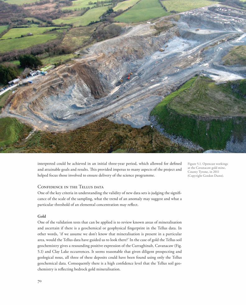
GoldOne of the validation tests that can be applied is to review known areas of mineralisation and ascertain if there is a geochemical or geophysical fingerprint in the Tellus data. In other words, ‘if we assume we don’t know that mineralisation is present in a particular area, would the Tellus data have guided us to look there?’ In the case of gold the Tellus soil geochemistry gives a resounding positive expression of the Curraghinalt, Cavanacaw (Fig. 5.1) and Clay Lake occurrences. It seems reasonable that given diligent prospecting and geological nous, all three of these deposits could have been found using only the Tellus geochemical data. Consequently there is a high confidence level that the Tellus soil geo-chemistry is reflecting bedrock gold mineralisation.
70
Figure 5.1. Opencast workings at the Cavanacaw gold mine, County Tyrone, in 2011 (Copyright Gordon Dunn).
However, on examining the pattern of the gold geochemistry across Northern Ireland there are numerous other geochemical anomalies that appear similar to those associated with Curraghinalt, Cavanacaw and Clay Lake. Several other soil anomalies reflect bedrock gold mineralisation and it is reasonable to assume that other significant gold deposits await discovery.
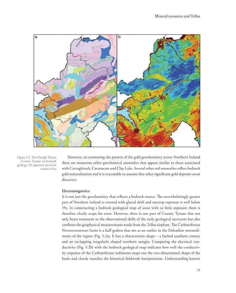
ElectromagneticsIt is not just the geochemistry that reflects a bedrock source. The overwhelmingly greater part of Northern Ireland is covered with glacial drift and outcrop exposure is well below 1%. In constructing a bedrock geological map of areas with so little exposure there is therefore clearly scope for error. However, there is one part of County Tyrone that not only bears testament to the observational skills of the early geological surveyors but also confirms the geophysical measurements made from the Tellus airplane. The Carboniferous Newtownstewart basin is a half graben that sits as an outlier in the Dalradian metasedi-ments of the region (Fig. 5.2a). It has a characteristic shape – a faulted southern contact and an on-lapping irregularly shaped northern margin. Comparing the electrical con-ductivity (Fig. 5.2b) with the bedrock geological map indicates how well the conductiv-ity response of the Carboniferous sediments maps out the two-dimensional shape of the basin and closely matches the historical fieldwork interpretation. Understanding known
71
Mineral resources and Tellus
Figure 5.2. The Omagh Thrust, County Tyrone: (a) bedrock
geology; (b) apparent electrical conductivity.
geological patterns and how they are geophysically expressed builds great confidence in interpretations made from the Tellus geophysical information in geologically less well-understood areas.
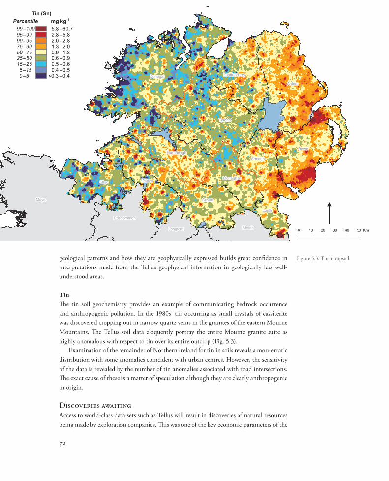
TinThe tin soil geochemistry provides an example of communicating bedrock occurrence and anthropogenic pollution. In the 1980s, tin occurring as small crystals of cassiterite was discovered cropping out in narrow quartz veins in the granites of the eastern Mourne Mountains. The Tellus soil data eloquently portray the entire Mourne granite suite as highly anomalous with respect to tin over its entire outcrop (Fig. 5.3).
Examination of the remainder of Northern Ireland for tin in soils reveals a more erratic distribution with some anomalies coincident with urban centres. However, the sensitivity of the data is revealed by the number of tin anomalies associated with road intersections. The exact cause of these is a matter of speculation although they are clearly anthropogenic in origin.
Discoveries awaitingAccess to world-class data sets such as Tellus will result in discoveries of natural resources being made by exploration companies. This was one of the key economic parameters of the
72
Mayo
Donegal
Sligo
Cavan
Leitrim
Meath
Louth
Roscommon
Monaghan
Longford
Tyrone
Antrim
Down
Londonderry
ArmaghFermanagh
0 10 20 30 40 50 Km
Tin (Sn)Percentile mg kg-1
5.8 – 60.799–1002.8 – 5.895–992.0 – 2.890–951.3 – 2.075–900.9 – 1.350–750.6 – 0.925–500.5 – 0.615–250.4 – 0.55–15
<0.3 – 0.40–5
Figure 5.3. Tin in topsoil.
proposal in securing funding for the project. Exploration geologists have a respectable track record of discovery when they have quality information to assess and interpret. You cannot predict the size or grade of a particular mineral occurrence before you start to search, but if you explore in the right geological environment for the right commodity there is a reason-able chance that you will find something to encourage further investigation.
In 1982 I visited the GSNI to research information regarding mineralisation reported from County Tyrone. At that time the data were stored on typed and handwritten infor-mation cards. I plotted all the known occurrences of mineralisation in the area under licence and started prospecting and panning the streams of the Sperrin Mountains. After four months of fieldwork we had found the first outcropping gold mineralisation in Ireland in modern times in Curraghinalt Burn. The point is not that we found it relatively quickly, but that we were able to find Curraghinalt by using geological knowledge allied with historical record keeping and prospecting. Had the Tellus data been available we would certainly have focused on that area earlier.
However, Curraghinalt was a relatively easy discovery. We were not the first geologists to prospect the area, but we were probably the first prospectors to hammer every outcrop of interest, read the landscape, examine iron discharges and assay every sample. Following on from the Curraghinalt discovery other companies began discovering gold in Ireland. Almost all of the discoveries were outcropping, or close to surface.
This is why the Tellus data can help geologists make discoveries in the future. Logi-cally there is little reason to believe that all the gold deposits have been found. We have discovered the ones that were easy to find. It is almost inconceivable that these are the only deposits; others undoubtedly remain that are concealed by overburden and do not outcrop. Understanding the Tellus geochemistry and geophysics will allow companies to focus their search and de-risk exploration, which should help the discovery process.
Scientific data sets such as those generated by the Tellus project represent a series of ‘snapshots’ or baselines of our rural and urban environments at the time of collection, and a regional geoscientific audit of the country. Future surveys may not need to be as compre-hensive, but should be carried out to allow assessment of data variation through time and facilitate comparisons to determine how society is managing our part of our planet.
Key decisions to be made: leadershipThe ownership of the Tellus data lies with the Northern Ireland government. During the collection and initial interpretation of the data the GSNI promoted Northern Ireland as a place to explore for minerals and hydrocarbons. As a result of the new data and extensive marketing, many new companies entered Northern Ireland to utilise the data in the quest to discover and understand our natural resources. Some were successful; some had techni-cal successes and others enhanced the prospectivity of their licences by defining geochemi-cal and geophysical anomalies. At all times the companies received strong support from government.
73
Mineral resources and Tellus
Over the past few years, increased interest in departmental responsibilities, especially regarding the administration and regulation of environmental legislation relating to drill-ing, has resulted in the exploration programmes of companies being partially stifled through lack of understanding of the exploration processes and practices. It is ironic that one part of government is charged with promoting natural resource exploration while other parts appear not to understand that delays in the permitting system will cause companies to reconsider if Northern Ireland is a location that is encouraging to natural resource explora-tion. This may cause companies to favour other jurisdictions that are more knowledgeable and pragmatic in dealing with the industry. Carrying this to its logical conclusion would diminish the value of the Tellus data sets to Northern Ireland.
The necessary balance is between governance, regulation and development; between communities, government and private sector. All segments must work together from posi-tions of understanding and inclusivity to facilitate knowledge-based decision-making that can be advantageous to stakeholders at all scales – local, regional and national.
In the 21st century much is made of the term ‘sustainable development’. Some will argue that it is inappropriate to term an industry that extracts commodities as ‘sustain-able’, as most commodities that are mined ultimately represent a finite resource. Some will argue that recycling can meet future needs, but for most commodities and materi-als recycling will not meet the demands of developing economies and a growing global population. In any case, clearly we can only recycle what we have already mined. We need materials to live, and although an individual mine may have a lifespan of tens of years, new mines will be found and the extractive industries must continue for the foreseeable future to meet demand.
We should remember that sustainable development is about managing, not prevent-ing, development. It is against this background that we need to utilise the Tellus data sets to discover new commodities in Northern Ireland and to play our part in developing our natural resources in a socially and environmentally responsible manner to benefit our communities.
Reference
Department of Enterprise, Trade and Investment (DETI), 2004 Resource and Environmental Survey of Northern Ireland (RESNI), Draft Economic Appraisal. Belfast.
74
Earls