Embed Size (px)
Citation preview

26
5. COMPUTATION OF GROUND WATER RESOURCES IN MADHYA
PRADESH
5.1 Salient features of the dynamic ground water resource assessments Year of
assessment –
Estimation of ground water resources has been carried out based on the
methodology recommended by the Ground Water Estimation Committee (GEC –1997)
and on advice of R&D committee. The base year for the assessment of ground water
resources is 2009-10 and data of rainfall, ground water structures, canal, tanks ponds etc.
are collected of five years from 2006 to 2010. The water level data are used from 2001to
2011.
Assessment Unit The administrative block has been considered as a unit of assessment. The unit is
further divided into sub-unit i.e. Command and Non-Command. The ground water
resources have been computed for all 313 blocks of the State.
5.2 Sub-Unit-Wise Method Adopted for Computing Rainfall Recharge During
Monsoon Season
The following sub-units are taken into account for the computation of various
figures in the methodology and have been considered as given below: -
(a) Hilly Area
Area having more than 20% slope has been excluded for ground water recharge
computation.
(b) Poor Ground Water Quality Area
There is no clear cut demarcated area of poor quality in the State for computation
of ground water resources. Apart from this, statistical data of ground water structure is
also not available. Hence this unit has not been considered for resource estimation.
(c) Command and Non-Command Area
In the methodology, it is recommended that dynamic ground water resources
estimation should be carried out for command area and non command area separately.
This has been followed. For computation of ground water resources of command area
only medium and major command areas have been considered so that area falling under
this category be clearly identified on the map and other isolated pockets are omitted. By
doing so it will be very clear in the block map, area showing under various categories
(semi critical and over exploited) are in continuation and same may be used for further
works etc.
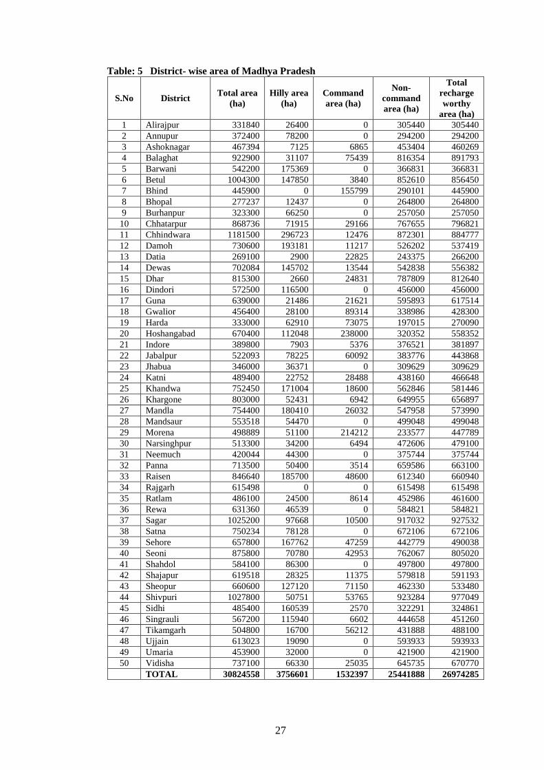
Block-wise total geographical areas, hilly area, command area, non command area
and area worthy for ground recharge are given in Annexure IIIA-2 whereas district-wise
geographical areas, hilly area, command area, non command area and area worthy for
ground recharge are shown in Table-5
27
Table: 5 District- wise area of Madhya Pradesh
S.No District Total area
(ha)
Hilly area
(ha)
Command
area (ha)
Non-
command
area (ha)
Total
recharge
worthy
area (ha)
1 Alirajpur 331840 26400 0 305440 305440
2 Annupur 372400 78200 0 294200 294200
3 Ashoknagar 467394 7125 6865 453404 460269
4 Balaghat 922900 31107 75439 816354 891793
5 Barwani 542200 175369 0 366831 366831
6 Betul 1004300 147850 3840 852610 856450
7 Bhind 445900 0 155799 290101 445900
8 Bhopal 277237 12437 0 264800 264800
9 Burhanpur 323300 66250 0 257050 257050
10 Chhatarpur 868736 71915 29166 767655 796821
11 Chhindwara 1181500 296723 12476 872301 884777
12 Damoh 730600 193181 11217 526202 537419
13 Datia 269100 2900 22825 243375 266200
14 Dewas 702084 145702 13544 542838 556382
15 Dhar 815300 2660 24831 787809 812640
16 Dindori 572500 116500 0 456000 456000
17 Guna 639000 21486 21621 595893 617514
18 Gwalior 456400 28100 89314 338986 428300
19 Harda 333000 62910 73075 197015 270090
20 Hoshangabad 670400 112048 238000 320352 558352
21 Indore 389800 7903 5376 376521 381897
22 Jabalpur 522093 78225 60092 383776 443868
23 Jhabua 346000 36371 0 309629 309629
24 Katni 489400 22752 28488 438160 466648
25 Khandwa 752450 171004 18600 562846 581446
26 Khargone 803000 52431 6942 649955 656897
27 Mandla 754400 180410 26032 547958 573990
28 Mandsaur 553518 54470 0 499048 499048
29 Morena 498889 51100 214212 233577 447789
30 Narsinghpur 513300 34200 6494 472606 479100
31 Neemuch 420044 44300 0 375744 375744
32 Panna 713500 50400 3514 659586 663100
33 Raisen 846640 185700 48600 612340 660940
34 Rajgarh 615498 0 0 615498 615498
35 Ratlam 486100 24500 8614 452986 461600
36 Rewa 631360 46539 0 584821 584821
37 Sagar 1025200 97668 10500 917032 927532
38 Satna 750234 78128 0 672106 672106
39 Sehore 657800 167762 47259 442779 490038
40 Seoni 875800 70780 42953 762067 805020
41 Shahdol 584100 86300 0 497800 497800
42 Shajapur 619518 28325 11375 579818 591193
43 Sheopur 660600 127120 71150 462330 533480
44 Shivpuri 1027800 50751 53765 923284 977049
45 Sidhi 485400 160539 2570 322291 324861
46 Singrauli 567200 115940 6602 444658 451260
47 Tikamgarh 504800 16700 56212 431888 488100
48 Ujjain 613023 19090 0 593933 593933
49 Umaria 453900 32000 0 421900 421900
50 Vidisha 737100 66330 25035 645735 670770
TOTAL 30824558 3756601 1532397 25441888 26974285
28
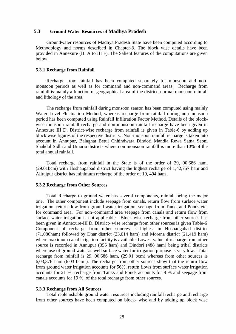
5.3 Ground Water Resources of Madhya Pradesh
Groundwater resources of Madhya Pradesh State have been computed according to
Methodology and norms described in Chapter-3. The block wise details have been
provided in Annexure (III A to III F). The Salient features of the computations are given
below.
5.3.1 Recharge from Rainfall
Recharge from rainfall has been computed separately for monsoon and non-
monsoon periods as well as for command and non-command areas. Recharge from
rainfall is mainly a function of geographical area of the district, normal monsoon rainfall
and lithology of the area.
The recharge from rainfall during monsoon season has been computed using mainly
Water Level Fluctuation Method, whereas recharge from rainfall during non-monsoon
period has been computed using Rainfall Infiltration Factor Method. Details of the block-
wise monsoon rainfall recharge and non-monsoon rainfall recharge have been given in
Annexure III D. District-wise recharge from rainfall is given in Table-6 by adding up
block wise figures of the respective districts. Non-monsoon rainfall recharge is taken into
account in Annupur, Balaghat Betul Chhindwara Dindori Mandla Rewa Satna Seoni
Shahdol Sidhi and Umaria districts where non monsoon rainfall is more than 10% of the
total annual rainfall.
Total recharge from rainfall in the State is of the order of 29, 00,686 ham,
(29.01bcm) with Hoshangabad district having the highest recharge of 1,42,757 ham and
Alirajpur district has minimum recharge of the order of 19, 494 ham .
5.3.2 Recharge from Other Sources
Total Recharge to ground water has several components, rainfall being the major
one. The other component include seepage from canals, return flow from surface water
irrigation, return flow from ground water irrigation, seepage from Tanks and Ponds etc.
for command area. For non–command area seepage from canals and return flow from
surface water irrigation is not applicable. Block wise recharge from other sources has
been given in Annexure-III D. District- wise recharge from other sources is given Table-6
Component of recharge from other sources is highest in Hoshangabad district
(71,080ham) followed by Dhar district (23,014 ham) and Morena district (21,419 ham)
where maximum canal irrigation facility is available. Lowest value of recharge from other
source is recorded in Annupur (355 ham) and Dindori (488 ham) being tribal districts
where use of ground water as well surface water for irrigation purpose is very low. Total
recharge from rainfall is 29, 00,686 ham, (29.01 bcm) whereas from other sources is
6,03,376 ham (6.03 bcm ). The recharge from other sources show that the return flow
from ground water irrigation accounts for 56%, return flows from surface water irrigation
accounts for 21 %, recharge from Tanks and Ponds accounts for 9 % and seepage from
canals accounts for 19 %, of the total recharge from other sources.
5.3.3 Recharge from All Sources
Total replenishable ground water resources including rainfall recharge and recharge
from other sources have been computed on block- wise and by adding up block wise

29
figures of the respective districts which is presented in Annexure III D and Table-6
respectively. Total annual recharge from all sources in the State is of the order of
35,04,063 ham (35.04 bcm), with Hoshangabad district having the highest recharge of
2,13,837 ham and Alirajpur district has minimum recharge of the order of 21,648 ham. A
thematic map showing annual replenishable ground water resources (m/unit area) is
prepared (Figure-5). The thematic map shows that annual replenishable ground water
resources in metre per unit area is maximum at Hoshangabad (0.38 m/ area) followed by
Narsinghpur (0.26 m/ area). In 11 districts, the annual replenishable ground water
resources in the state is found between 0.07 to 0.09 m/ area, whereas in 29 districts,
between 0.10 to 0.15 m/ area and 8 district have 0.16-0.19 m/unit area. The average
annual replenishable ground water resources of the State is 0.13 m/ area Table- 6 District- wise dynamic ground water resource of Madhya Pradesh.
S.
No
Dis
tric
t
Rec
ha
rge
Fro
m
R
ain
fall
du
rin
g
Mo
nso
on
Sea
son
(h
am
)
Rec
ha
rge
Fro
m R
ain
fall
du
rin
g N
on
Mo
nso
on
Sea
son
(h
am
)
Rec
ha
rge
Fro
m O
ther
So
urc
es
du
rin
g
Mo
nso
on
Sea
son
(h
am
)
Rec
ha
rge
Fro
m O
ther
So
urc
es
du
rin
g
No
n M
on
soo
n S
easo
n
(ha
m)
To
tal
An
nu
al
gro
un
d w
ate
r R
ech
arg
e
(ha
m)
Na
tura
l D
isch
arg
e d
uri
ng
No
n M
on
soo
n
Per
iod
(h
am
)
Net
Gro
un
d W
ate
r A
va
ila
bil
ity
(h
am
)
An
nu
al
rep
len
ish
ab
le
Gro
un
d
wa
ter
reso
urc
es
(m/u
nit
are
a)
1 Alirajpur 19494 0 801 1352 21648 1082 20565 0.07
2 Annupur 34230 5578 99 257 40163 2008 38155 0.14
3 Ashoknagar 36962 0 1650 5556 44168 2208 41959 0.10
4 Balaghat 81283 8091 3872 2579 95825 4791 91034 0.11
5 Barwani 36947 0 1444 5083 43475 2174 41301 0.12
6 Betul 94384 12410 3022 10141 119956 5998 113959 0.14
7 Bhind 51997 2061 749 11165 65972 3299 62673 0.15
8 Bhopal 31933 0 1863 5431 39227 1961 37266 0.15
9 Burhanpur 29082 0 877 4118 34077 1704 32373 0.13
10 Chhatarpur 64451 0 3049 11278 78778 3939 74839 0.10
11 Chhindwara 109835 11905 4133 13734 139607 6980 132627 0.16
12 Damoh 32722 0 1403 8091 42217 2111 40106 0.08
13 Datia 28596 0 684 5475 34756 1738 33018 0.13
14 Dewas 71825 0 2759 13063 87646 4382 83264 0.16
15 Dhar 80003 0 4483 18531 103017 5151 97867 0.13
16 Dindori 39722 4683 106 343 44853 2243 42611 0.10
17 Guna 64703 0 3348 10897 78949 3947 75002 0.13
18 Gwalior 35580 1318 3726 12204 52828 2641 50187 0.12
19 Harda 35662 0 2764 15286 53712 2686 51026 0.20
20 Hoshangabad 142757 0 10334 60746 213837 10692 203145 0.38
21 Indore 44272 0 3624 12193 60089 3004 57084 0.16
22 Jabalpur 51942 980 2675 6640 62238 3112 59126 0.14

30
S.
No
Dis
tric
t
Rec
ha
rge
Fro
m
R
ain
fall
du
rin
g M
on
soo
n
Sea
son
(h
am
)
Rec
ha
rge
Fro
m R
ain
fall
du
rin
g N
on
Mo
nso
on
Sea
son
(h
am
)
Rec
ha
rge
Fro
m O
ther
So
urc
es
du
rin
g M
on
soo
n
Sea
son
(h
am
)
Rec
ha
rge
Fro
m O
ther
So
urc
es
du
rin
g N
on
Mo
nso
on
Sea
son
(h
am
)
To
tal
An
nu
al
gro
un
d w
ate
r R
ech
arg
e (h
am
)
Na
tura
l D
isch
arg
e d
uri
ng
No
n M
on
soo
n
Per
iod
(h
am
)
Net
Gro
un
d W
ate
r A
va
ila
bil
ity
(h
am
)
An
nu
al
rep
len
ish
ab
le
Gro
un
d
wa
ter
reso
urc
es
(m/u
nit
are
a)
23 Jhabua 20706 0 722 1785 23214 1161 22053 0.07
24 Katni 34444 0 1838 4786 41068 2053 39015 0.09
25 Khandwa 72460 0 1825 9533 83818 4191 79627 0.14
26 Khargone 65142 0 2821 11677 79640 3982 75658 0.12
27 Mandla 48261 6601 732 3007 58603 2930 55672 0.10
28 Mandsaur 46733 0 2385 11115 60232 3012 57221 0.12
29 Morena 41592 1079 959 20459 64089 3204 60885 0.14
30 Narsinghpur 105594 0 2890 14196 122679 6134 116545 0.26
31 Neemuch 31755 0 3695 7345 42795 2140 40656 0.11
32 Panna 50500 0 838 3292 54629 2731 51897 0.08
33 Raisen 83521 0 3012 8479 95013 4751 90262 0.14
34 Rajgarh 77303 0 3317 10528 91148 4557 86590 0.15
35 Ratlam 56957 0 4350 16258 77565 3878 73687 0.17
36 Rewa 42292 2610 915 3596 49413 2471 46942 0.08
37 Sagar 110939 0 3425 14738 129102 6455 122647 0.14
38 Satna 43518 4309 2147 7038 57012 2851 54162 0.08
39 Sehore 62638 0 3436 12873 78947 3947 74999 0.16
40 Seoni 68249 551 1396 4509 74706 3735 70970 0.09
41 Shahdol 59636 7502 216 508 67862 3393 64469 0.14
42 Shajapur 83175 0 4187 16745 104108 5205 98902 0.18
43 Sheopur 30388 0 587 13631 44606 2230 42376 0.08
44 Shivpuri 63109 0 2995 12517 78621 3931 74690 0.08
45 Sidhi 29807 3277 727 2184 35995 1800 34195 0.11
46 Singrauli 34818 0 683 2057 37558 1878 35680 0.08
47 Tikamgarh 43531 0 2819 12252 58602 2930 55672 0.12
48 Ujjain 74887 0 4064 16932 95883 4794 91088 0.16
49 Umaria 39318 5917 340 811 46386 2319 44067 0.11
50 Vidisha 82160 0 2058 9513 93731 4687 89045 0.14
Total (ham) 2821816 78871 116846 486530 3504063 175203 3328860 0.13
Total (bcm) 28.22 0.79 1.17 4.87 35.04 1.75 33.29

31
Figure: 5 Annual replenishable ground water resources in Madhya Pradesh

32
5.3.4 Unaccounted Natural Discharge and Net Ground Water Availability
The total annual ground water recharge of the area is the sum of monsoon and
non-monsoon recharge. An allowance of 5% of total annual ground water recharge has
been kept for natural discharge in the non-monsoon season because WLF method is
employed to compute rainfall recharge during monsoon season. The balance ground water
available accounts for existing net ground water availability for various uses and potential
for future development. Block wise unaccounted natural discharge and net ground water
availability is given in Annexure-III D whereas district wise unaccounted natural
discharge and net ground water availability is given in Table -6 . Total unaccounted
natural discharge in the State is of the order of 1,75,203 ham (1.75 bcm), with
Hoshangabad district having the highest discharge of 10,692 ham and Alirajpur with
lowest of 1,082ham. The net ground water availability in the state is 33,28,860 ham
(33.29 bcm) with Hoshangabad district having the highest net ground water availability of
2,03,145 ham and Alirajpur with lowest of 20,565 ham.
5.3.5 Ground Water Draft for Various Uses
Ground water draft for various uses has been calculated separately for command
and non-command areas. Details of block-wise groundwater draft for various uses are
given in Annexure – III D. District-wise ground water draft figures are also compiled and
given in Table – 7
Total draft of ground water for all uses in state is calculated as 18,83,352 ham
(18.83 bcm). From the Table-7, it is seen that maximum ground water drawl for all uses
is 96,822 ham in Shajapur district and minimum draft of ground water for all uses is 2,180
ham in Annupur district at eastern part of Madhya Pradesh. Comparison of ground water
draft for various uses reveals that draft for irrigation accounts for more than 93% of total
ground water draft, where as draft for domestic & industrial supply accounts for meager
7% of the total ground water draft in the state.
Table-7 District -wise Ground Water Draft for Various Uses and Stage of Ground Water
Development
S.
No
Dis
tric
t
Net
An
nu
al
Gro
un
d w
ate
r
Av
ail
ab
ilit
y (
ha
m)
Ex
isti
ng
Gro
ss G
rou
nd
wa
ter D
raft
fo
r Ir
rig
ati
on
(ha
m)
Ex
isti
ng
Gro
ss G
rou
nd
wa
ter
Dra
ft f
or
Do
mes
tic
&
In
du
stri
al
wa
ter S
up
ply
(h
am
)
Ex
isti
ng
Gro
ss G
rou
nd
wa
ter D
raft
fo
r A
ll u
ses
(ha
m)
Pro
vis
ion
fo
r d
om
esti
c, a
nd
ind
ust
ria
l req
uir
emen
t
su
pp
ly t
o
nex
t 2
5 y
ear
(20
35
) (h
am
)
Net
Gro
un
d w
ate
r
Av
ail
ab
ilit
y
fo
r fu
ture
irri
ga
tio
n d
evel
op
men
t
(ha
m)
Sta
ge
of
Gro
un
d
wa
ter
Dev
elo
pm
ent
(%
)
Cu
rren
t B
ala
nce
(h
am
)
1 Alirajpur 20565 3802 2162 5964 5825 10939 29 14601
2 Annupur 38155 1017 1162 2180 2634 34503 6 35975
3 Ashoknagar 41959 18738 1588 20326 3420 19801 48 21633
4 Balaghat 91034 9620 3107 12728 4144 77269 14 78306
5 Barwani 41301 26800 3019 29819 5044 9457 72 11482
6 Betul 113959 55565 3594 59159 4813 53580 52 54800
7 Bhind 62673 22632 2764 25396 8094 31947 41 37278
8 Bhopal 37266 25719 2356 28075 3211 8336 75 9191
9 Burhanpur 32373 23504 1147 24651 1422 7446 76 7721
10 Chhatarpur 74839 47508 2761 50270 4059 23272 67 24569

33
S.
No
Dis
tric
t
Net
An
nu
al
Gro
un
d w
ate
r
Av
ail
ab
ilit
y (
ha
m)
Ex
isti
ng
Gro
ss G
rou
nd
wa
ter D
raft
fo
r Ir
rig
ati
on
(ha
m)
Ex
isti
ng
Gro
ss G
rou
nd
wa
ter
Dra
ft f
or
Do
mes
tic
&
In
du
stri
al
wa
ter S
up
ply
(h
am
)
Ex
isti
ng
Gro
ss G
rou
nd
wa
ter D
raft
fo
r A
ll u
ses
(ha
m)
Pro
vis
ion
fo
r d
om
esti
c, a
nd
ind
ust
ria
l req
uir
emen
t
su
pp
ly t
o
nex
t 2
5 y
ear
(20
35
) (h
am
)
Net
Gro
un
d w
ate
r
Av
ail
ab
ilit
y
fo
r fu
ture
irri
ga
tio
n d
evel
op
men
t
(ha
m)
Sta
ge
of
Gro
un
d
wa
ter
Dev
elo
pm
ent
(%
)
Cu
rren
t B
ala
nce
(h
am
)
11 Chhindwar
a 132627 64955 5274 70230 7278 60393 53 62397
12 Damoh 40106 22861 2113 24974 3662 13583 62 15132
13 Datia 33018 14598 1248 15847 1928 16492 48 17171
14 Dewas 83264 65523 2623 68146 3915 13825 82 15118
15 Dhar 97867 75257 5005 80262 12222 10387 82 17605
16 Dindori 42611 1857 1384 3241 1714 39040 8 39370
17 Guna 75002 38689 2665 41354 3389 32923 55 33647
18 Gwalior 50187 19710 1979 21689 6785 23692 43 28498
19 Harda 51026 13730 976 14706 1330 35966 29 36320
20 Hoshangabad 203145 35051 2933 37984 4348 163745 19 165161
21 Indore 57084 65109 3369 68478 4183 -12207 120 -11394
22 Jabalpur 59126 25989 3141 29130 5198 27939 49 29995
23 Jhabua 22053 7657 2366 10023 5842 8554 45 12030
24 Katni 39015 13404 2549 15953 4528 21082 41 23061
25 Khandwa 79627 46898 2862 49760 4976 27753 62 29867
26 Khargone 75658 53171 3467 56638 5264 17223 75 19020
27 Mandla 55672 6218 2248 8465 3200 46255 15 47207
28 Mandsaur 57221 51972 3229 55201 3496 1752 96 2020
29 Morena 60885 20623 4289 24912 9549 30713 41 35973
30 Narsinghpur 116545 85929 2168 88097 3006 27610 76 28448
31 Neemuch 40656 32094 1749 33843 1973 6588 83 6812
32 Panna 51897 11531 2101 13633 3537 36829 26 38265
33 Raisen 90262 37095 3168 40263 4413 48754 45 49999
34 Rajgarh 86590 68296 3457 71753 4712 13583 83 14838
35 Ratlam 73687 90218 2382 92601 2863 -19394 126 -18914
36 Rewa 46942 20570 4609 25179 5970 20402 54 21764
37 Sagar 122647 69993 2418 72411 10295 42360 59 50236
38 Satna 54162 35041 5167 40208 5996 13125 74 13954
39 Sehore 74999 55106 2585 57692 5787 14106 77 17308
40 Seoni 70970 17504 3029 20532 10537 42930 29 50438
41 Shahdol 64469 2305 1928 4233 5282 56882 7 60236
42 Shajapur 98902 93239 3583 96822 4288 1375 98 2080
43 Sheopur 42376 14218 1274 15492 1782 26375 37 26884
44 Shivpuri 74690 47917 3226 51143 4438 22335 68 23547
45 Sidhi 34195 10705 2433 13138 3576 19914 38 21057
46 Singrauli 35680 8555 2257 10812 3775 23350 30 24868
47 Tikamgarh 55672 37827 2348 40175 3813 14032 72 15498
48 Ujjain 91088 83560 3141 86701 3935 3594 95 4387
49 Umaria 44067 3661 1277 4937 3714 36693 11 39130
50 Vidisha 89045 44543 3585 48128 5084 39418 54 40917
Total (ham) 3328860 1748087 135265 1883352 234250 1346522 57 1445507
Total bcm) 33.29 17.48 1.35 18.83 2.34 13.47 14.46
34
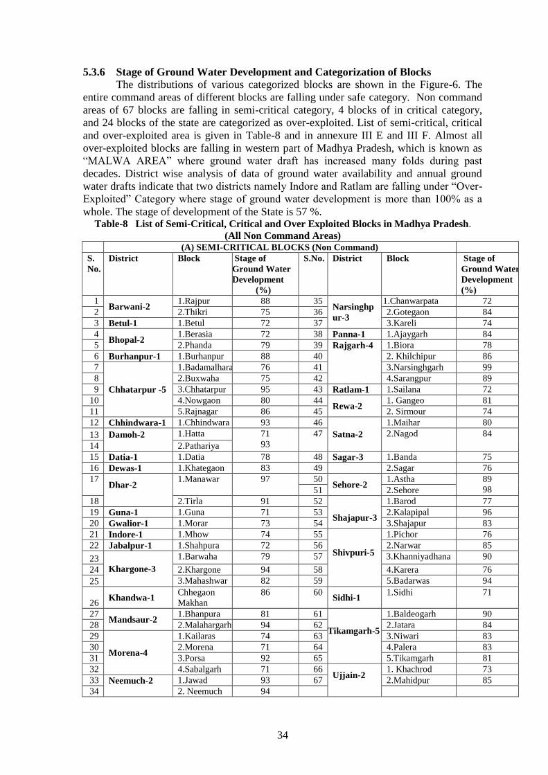
5.3.6 Stage of Ground Water Development and Categorization of Blocks
The distributions of various categorized blocks are shown in the Figure-6. The
entire command areas of different blocks are falling under safe category. Non command
areas of 67 blocks are falling in semi-critical category, 4 blocks of in critical category,
and 24 blocks of the state are categorized as over-exploited. List of semi-critical, critical
and over-exploited area is given in Table-8 and in annexure III E and III F. Almost all
over-exploited blocks are falling in western part of Madhya Pradesh, which is known as
“MALWA AREA” where ground water draft has increased many folds during past
decades. District wise analysis of data of ground water availability and annual ground
water drafts indicate that two districts namely Indore and Ratlam are falling under “Over-
Exploited” Category where stage of ground water development is more than 100% as a
whole. The stage of development of the State is 57 %. Table-8 List of Semi-Critical, Critical and Over Exploited Blocks in Madhya Pradesh.
(All Non Command Areas) (A) SEMI-CRITICAL BLOCKS (Non Command)
S.
No.
District Block Stage of
Ground Water
Development
(%)
S.No. District Block Stage of
Ground Water
Development
(%)
1 Barwani-2
1.Rajpur 88 35 Narsinghp
ur-3
1.Chanwarpata 72
2 2.Thikri 75 36 2.Gotegaon 84
3 Betul-1 1.Betul 72 37 3.Kareli 74
4 Bhopal-2
1.Berasia 72 38 Panna-1 1.Ajaygarh 84
5 2.Phanda 79 39 Rajgarh-4 1.Biora 78
6 Burhanpur-1 1.Burhanpur 88 40 2. Khilchipur 86
7
Chhatarpur -5
1.Badamalhara 76 41 3.Narsinghgarh 99
8 2.Buxwaha 75 42 4.Sarangpur 89
9 3.Chhatarpur 95 43 Ratlam-1 1.Sailana 72
10 4.Nowgaon 80 44 Rewa-2
1. Gangeo 81
11 5.Rajnagar 86 45 2. Sirmour 74
12 Chhindwara-1 1.Chhindwara 93 46
Satna-2
1.Maihar 80
13 Damoh-2
1.Hatta 71
93
47
2.Nagod 84
14 2.Pathariya
15 Datia-1 1.Datia 78 48 Sagar-3 1.Banda 75
16 Dewas-1 1.Khategaon 83 49 2.Sagar 76
17 Dhar-2
1.Manawar 97 50 Sehore-2
1.Astha 89
98 51 2.Sehore
18 2.Tirla 91 52
Shajapur-3
1.Barod 77
19 Guna-1 1.Guna 71 53 2.Kalapipal 96
20 Gwalior-1 1.Morar 73 54 3.Shajapur 83
21 Indore-1 1.Mhow 74 55
Shivpuri-5
1.Pichor 76
22 Jabalpur-1 1.Shahpura 72 56 2.Narwar 85
23 Khargone-3
1.Barwaha 79 57 3.Khanniyadhana 90
24 2.Khargone 94 58 4.Karera 76
25 3.Mahashwar 82 59 5.Badarwas 94
26 Khandwa-1
Chhegaon
Makhan
86 60 Sidhi-1
1.Sidhi 71
27 Mandsaur-2
1.Bhanpura 81 61
Tikamgarh-5
1.Baldeogarh 90
28 2.Malahargarh 94 62 2.Jatara 84
29
Morena-4
1.Kailaras 74 63 3.Niwari 83
30 2.Morena 71 64 4.Palera 83
31 3.Porsa 92 65 5.Tikamgarh 81
32 4.Sabalgarh 71 66 Ujjain-2
1. Khachrod 73
33 Neemuch-2
1.Jawad 93 67 2.Mahidpur 85
34 2. Neemuch 94

35
B- CRITICAL BLOCKS (Non Command)
S.No. District Block
Stage of
Ground
Water
Development
(%)
S.No. District Block
Stage of
Ground Water
Development
(%)
1 Narsinghpur-1 1.Narsinghpur 95 4 Shajapur -1 1.Agar 91
2 Satna-2
1.Amarpatan 94
3 2.Sohawal 96
C-OVER EXPLOITED BLOCKS (Non Command)
S.N. District Block
Stage of
Ground
Water
Development
(%)
S.N. District Block
Stage of
Ground Water
Development
(%)
1 Barwani-1 Pansemal 115 13
Ratlam-4
1.Alote 113
2 Dewas-2
1.Dewas 109 14 2.Jaora 167
3 2.Sonkutch 104 15 3.Piploda 168
4
Dhar-4
1.Badnawar 103 16 4.Ratlam 106
5 2.Dhar 136 17
Satna-1 1.Rampur
Baghalan
102
6 3.Dharampuri 108 18
Shajapur-4
1.Mohan
Barodia
134
7 4. Nalcha 107 19 2.Nalkhera 117
8 Indore-3
1.Depalpur 123 20 3.Shujalpur 103
9 2.Indore 148 21 4.Susner 102
10 3.Sanwer 134 22
Ujjain-3
1.Badnagar 117
11 Mandsaur-2 1.Mandsaur 116 23 2.Ghatia 102
12 2.Sitamau 104 24 3.Ujjain 125
5.3.7 Ground Water Available for Future Irrigation and Irrigations Potential
Block-wise balance ground water for future irrigation potential is determined for all
313 blocks of Madhya Pradesh by deducting ground water draft for irrigation and
allocation for next 25 years (upto year 2035) for drinking and industrial water supply
from net ground water availability. The ground water available for future irrigation is
divided by an average of depth of irrigation (), considering of 0.40 m for Madhya
Pradesh, which ultimately gives irrigation potentials.
Block-wise, data of irrigation potential is given in Annexure-III D and district wise
irrigation potential is shown in Table-9. From Table-9, it is seen that in Madhya Pradesh
13,46,522 ham (13.47 bcm) ground water is estimated to be available for future
irrigation, which can irrigate additional area of 33,66,305 hectare. Two districts namely
Indore and Ratlam, as whole fall under “Over Exploited” Category during the assessment
year where balance of ground water is estimated as nil for future irrigation, while Ujjain
will have minimum irrigation potential after as it is very close to 100% development
projecting the domestic and industrial draft for the year 2035.

36
Figure 6: Block-wise category of ground water development in Madhya Pradesh as on March, 2009

37
Table: 9 District -wise balance of ground water for future irrigation use and future
irrigation potential
S. No
District
Net Annual
Ground
water
Availability
(ham)
Existing
Gross
Ground
water
Draft for
Irrigation
(ham)
Provision for
domestic, and
industrial
requirement
supply to next
25 year (2035)
(ham)
Net Ground
water
Availability
for future
irrigation
development
(ham)
Future
Irrigation
Potential
(ha)
1 Alirajpur 20565 3802 5825 10939 27347
2 Annupur 38155 1017 2634 34503 86259
3 Ashoknagar 41959 18738 3420 19801 49502
4 Balaghat 91034 9620 4144 77269 193173
5 Barwani 41301 26800 5044 9457 23643
6 Betul 113959 55565 4813 53580 133951
7 Bhind 62673 22632 8094 31947 79868
8 Bhopal 37266 25719 3211 8336 20841
9 Burhanpur 32373 23504 1422 7446 18616
10 Chhatarpur 74839 47508 4059 23272 58179
11 Chhindwara 132627 64955 7278 60393 150983
12 Damoh 40106 22861 3662 13583 33958
13 Datia 33018 14598 1928 16492 41229
14 Dewas 83264 65523 3915 13825 34564
15 Dhar 97867 75257 12222 10387 25969
16 Dindori 42611 1857 1714 39040 97599
17 Guna 75002 38689 3389 32923 82307
18 Gwalior 50187 19710 6785 23692 59229
19 Harda 51026 13730 1330 35966 89915
20 Hoshangabad 203145 35051 4348 163745 409363
21 Indore 57084 65109 4183 -12207 -30519
22 Jabalpur 59126 25989 5198 27939 69848
23 Jhabua 22053 7657 5842 8554 21386
24 Katni 39015 13404 4528 21082 52706
25 Khandwa 79627 46898 4976 27753 69382
26 Khargone 75658 53171 5264 17223 43056
27 Mandla 55672 6218 3200 46255 115637
28 Mandsaur 57221 51972 3496 1752 4381
29 Morena 60885 20623 9549 30713 76782
30 Narsinghpur 116545 85929 3006 27610 69024
31 Neemuch 40656 32094 1973 6588 16471
32 Panna 51897 11531 3537 36829 92072
33 Raisen 90262 37095 4413 48754 121886
34 Rajgarh 86590 68296 4712 13583 33957
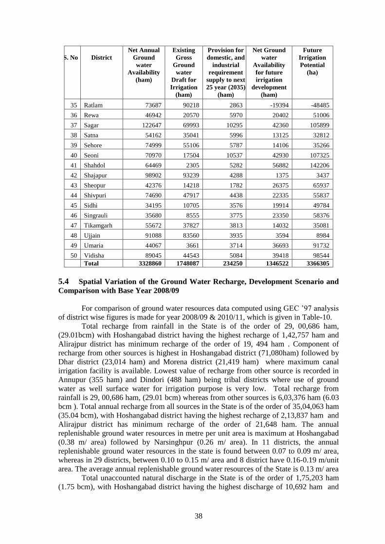
38
S. No
District
Net Annual
Ground
water
Availability
(ham)
Existing
Gross
Ground
water
Draft for
Irrigation
(ham)
Provision for
domestic, and
industrial
requirement
supply to next
25 year (2035)
(ham)
Net Ground
water
Availability
for future
irrigation
development
(ham)
Future
Irrigation
Potential
(ha)
35 Ratlam 73687 90218 2863 -19394 -48485
36 Rewa 46942 20570 5970 20402 51006
37 Sagar 122647 69993 10295 42360 105899
38 Satna 54162 35041 5996 13125 32812
39 Sehore 74999 55106 5787 14106 35266
40 Seoni 70970 17504 10537 42930 107325
41 Shahdol 64469 2305 5282 56882 142206
42 Shajapur 98902 93239 4288 1375 3437
43 Sheopur 42376 14218 1782 26375 65937
44 Shivpuri 74690 47917 4438 22335 55837
45 Sidhi 34195 10705 3576 19914 49784
46 Singrauli 35680 8555 3775 23350 58376
47 Tikamgarh 55672 37827 3813 14032 35081
48 Ujjain 91088 83560 3935 3594 8984
49 Umaria 44067 3661 3714 36693 91732
50 Vidisha 89045 44543 5084 39418 98544
Total 3328860 1748087 234250 1346522 3366305
5.4 Spatial Variation of the Ground Water Recharge, Development Scenario and
Comparison with Base Year 2008/09
For comparison of ground water resources data computed using GEC ’97 analysis
of district wise figures is made for year 2008/09 & 2010/11, which is given in Table-10.
Total recharge from rainfall in the State is of the order of 29, 00,686 ham,
(29.01bcm) with Hoshangabad district having the highest recharge of 1,42,757 ham and
Alirajpur district has minimum recharge of the order of 19, 494 ham . Component of
recharge from other sources is highest in Hoshangabad district (71,080ham) followed by
Dhar district (23,014 ham) and Morena district (21,419 ham) where maximum canal
irrigation facility is available. Lowest value of recharge from other source is recorded in
Annupur (355 ham) and Dindori (488 ham) being tribal districts where use of ground
water as well surface water for irrigation purpose is very low. Total recharge from
rainfall is 29, 00,686 ham, (29.01 bcm) whereas from other sources is 6,03,376 ham (6.03
bcm ). Total annual recharge from all sources in the State is of the order of 35,04,063 ham
(35.04 bcm), with Hoshangabad district having the highest recharge of 2,13,837 ham and
Alirajpur district has minimum recharge of the order of 21,648 ham. The annual
replenishable ground water resources in metre per unit area is maximum at Hoshangabad
(0.38 m/ area) followed by Narsinghpur (0.26 m/ area). In 11 districts, the annual
replenishable ground water resources in the state is found between 0.07 to 0.09 m/ area,
whereas in 29 districts, between 0.10 to 0.15 m/ area and 8 district have 0.16-0.19 m/unit
area. The average annual replenishable ground water resources of the State is 0.13 m/ area
Total unaccounted natural discharge in the State is of the order of 1,75,203 ham
(1.75 bcm), with Hoshangabad district having the highest discharge of 10,692 ham and

39
Alirajpur with lowest of 1,082ham. The net ground water availability in the state is
33,28,860 ham (33.29 bcm) with Hoshangabad district having the highest net ground
water availability of 2,03,145 ham and Alirajpur with lowest of 20,565 ham.
Total draft of ground water for all uses in state is calculated as 18,83,352 ham
(18.83 bcm). From the Table-7, it is seen that maximum ground water drawl for all uses
is 96,822 ham in Shajapur district and minimum draft of ground water for all uses is 2,180
ham in Annupur district at eastern part of Madhya Pradesh. Comparison of ground water
draft for various uses reveals that draft for irrigation accounts for more than 93% of total
ground water draft, where as draft for domestic & industrial supply accounts for meager
7% of the total ground water draft in the state.
The entire command areas of different blocks are falling under safe category. Non
command areas of 67 blocks are falling in semi-critical category, 4 blocks in critical
category, and 24 blocks of the state are categorized as over-exploited. Almost all over-
exploited blocks are falling in western part of Madhya Pradesh, which is known as
“MALWA AREA” where ground water draft has increased many folds during past
decades. District wise analysis of data of ground water availability and annual ground
water drafts indicate that two districts namely Indore and Ratlam are falling under “Over-
Exploited” Category where stage of ground water development is more than 100% as a
whole. The stage of development of the State is 57 %.
The net ground water availability in the state computed in 2008/09 was 32, 24,948 ham
which is lower as compared to current data of 33, 28,860 ham. In general, the reasons for
changes are attributed to increase in recharge because of localized improvement in
rainfall pattern, increased in activity on rainwater harvesting and water conservation
measures etc. In addition, management practices like efficient water use practices with
community participation, increased awareness etc. also helped in improving water use
efficiency of ground water resources in stressed areas. In majority of the cases, it is the
combination of the above mentioned reasons which have brought in the changes in
category.
Though total draft of ground water for all uses in state is increased by 4.7 %
whereas stage of ground water development has reached to 57 % as compared to 57 in
assessment year 2008/09 with increment of 1.0 %. In fact, more variations are observed
at assessment unit level.
In the assessment year-2008/09, 61 blocks falling in semi-critical category has
increased to 67 in 201011whereas blocks under critical and over-exploited category
remain same as 4 and 24 respectively in both assessments years. Seven new blocks
namely Berasia of Bhopal district, Betul of Betul district, Guna of Guna district, Shahpura
of Jabalpur district, Porsa of Morena district, Sirmour of Rewa district and Sidhi of Sidhi
District have been upgraded from safe to Semi critical. Rehli block of Sagar district has
been downgraded into safe category. The status of block under critical and over exploited
remain same as compared to the assessment year 2008/09. Likewise two districts namely
Indore and Ratlam, as whole falling under “Over Exploited” Category with ground water
development of more than 100% during the assessment year 2008/09 are also unchanged.
The status of changing the category from semi critical to safe and reduction of ground
water stage of development in blocks and districts are due to improving of the ground
water condition by recharge from other resources, decrease in unit draft of ground
structures and receiving good normal rainfall etc.
The ground water resources of the individual block /assessment unit show wide
variation in the resource available and stage of ground water development. In Madhya

40
Pradesh, the ground water development concentrates mainly in the western (Malwa
Region), Central (Narsinghpur districts), Budelkhand Region and part of Bagkhelkhand
Region of the State. The other part of the state has very low development of ground
water. Sixteen districts in the state have stage of development between 60%. to 90 %,
whereas three district have stage of ground water development 90 to 100 %. The Indore
and Ratlam districts reached at highest ground water development of 120. % and 126.0%
respectively and Anuppur with 7 % of development is lowest developed district in state.
The overall development of Madhya Pradesh in ground water point of view is 57 %,
which is moderate. District-wise ground water resource scenario is described below.
Table: 10 District -wise Balance of ground water for future and stage of development
S. No. District Net Ground Water
Available (ham)
Gross Ground
Water Draft (ham)
Current Balance of
Ground Water
Resources (ham)
Stage of Ground
water
Development (%)
2008/09 2010/11 2008/09 2010/11 2008/09 2010/11 2008/09 2010/11
1 Alirajpur 20148 20565 5428 5964 14720 14601 27 29
2 Annupur 37730 38155 2250 2180 35481 35975 6 6
3 Ashoknagar 40423 41959 16886 20326 23537 21633 42 48
4 Balaghat 91248 91034 13361 12728 77887 78306 15 14
5 Barwani 39593 41301 28382 29819 11211 11482 72 72
6 Betul 113970 113959 53622 59159 60349 54800 47 52
7 Bhind 58781 62673 22210 25396 36571 37278 38 41
8 Bhopal 32724 37266 26614 28075 6110 9191 81 75
9 Burhanpur 31556 32373 22086 24651 9470 7721 70 76
10 Chhatarpur 68567 74839 45055 50270 23512 24569 66 67
11 Chhindwara 138594 132627 71239 70230 67355 62397 51 53
12 Damoh 36385 40106 22000 24974 14385 15132 60 62
13 Datia 33420 33018 19162 15847 14258 17171 57 48
14 Dewas 79141 83264 63383 68146 15758 15118 80 82
15 Dhar 97163 97867 80451 80262 16712 17605 83 82
16 Dindori 40555 42611 3125 3241 37430 39370 8 8
17 Guna 71020 75002 40459 41354 30560 33647 57 55
18 Gwalior 50786 50187 21557 21689 29229 28498 42 43
19 Harda 54072 51026 13034 14706 41038 36320 24 29
20 Hoshangabad 201888 203145 35617 37984 166270 165161 18 19
21 Indore 52314 57084 65620 68478 -13307 -11394 125 120
22 Jabalpur 55679 59126 28184 29130 27495 29995 51 49
23 Jhabua 20134 22053 9305 10023 10828 12030 46 45
24 Katni 34508 39015 15457 15953 19051 23061 45 41
25 Khandwa 76949 79627 47583 49760 29366 29867 62 62
26 Khargone 77219 75658 55848 56638 21371 19020 72 75

41
ALIRAJPUR
Alirajpur district is underlain by Archaeans granite-gneisses,phyllite Basaltic lava
flows of Deccan trap and Bagh Bed. Dynamic Ground water resources of the district
have been estimated for base year-2010/11, on block wise basis. Out of 3,31,860 ha of
geographical area, 3,05,440 ha ( 91%) is ground water recharge worthy area and 26,400
ha (9%) is hilly area. There are six number of assessment units (block) in the district
which fall under which fall under non-command category, as there are no major irrigation
projects in the district, and medium irrigation project is not irrigating the area to its
designed capacity. All blocks of the district are categorized as safe blocks, and highest
stage of ground water development is computed as 47 % for Bhabra Block. The net
ground water availability in the district is 20,565 ham and ground water draft for all uses
is 5,964 ham, making stage of ground water development 29 % (27 % in 2008/09) as a
whole for district. After making allocation for future domestic and industrial supply for
next 25 years, balance available ground water for future irrigation would be 10,939 ham
at 50 % stage of ground water development’s safe limits in the district.
S. No. District Net Ground Water
Available (ham)
Gross Ground
Water Draft (ham)
Current Balance of
Ground Water
Resources (ham)
Stage of Ground
water
Development (%)
2008/09 2010/11 2008/09 2010/11 2008/09 2010/11 2008/09 2010/11
27 Mandla 55672 8205 8465 8465 45573 47207 15 15
28 Mandsaur 57221 54150 55201 55201 1474 2020 97 96
29 Morena 60885 27597 24912 24912 36646 35973 43 41
30 Narsinghpur 116545 94590 88097 88097 28010 28448 77 76
31 Neemuch 40656 31672 33843 33843 7462 6812 81 83
32 Panna 51897 12938 13633 13633 34170 38265 27 26
33 Raisen 90262 38165 40263 40263 37045 49999 51 45
34 Rajgarh 86590 69067 71753 71753 15669 14838 82 83
35 Ratlam 73687 83748 92601 92601 -17111 -18914 126 126
36 Rewa 46942 24289 25179 25179 22512 21764 52 54
37 Sagar 122647 66079 72411 72411 46728 50236 59 59
38 Satna 54162 39453 40208 40208 13497 13954 75 74
39 Sehore 74999 57394 57692 57692 19777 17308 74 77
40 Seoni 70970 20456 20532 20532 58783 50438 26 29
41 Shahdol 64469 4083 4233 4233 59826 60236 6 7
42 Shajapur 98902 88825 96822 96822 3316 2080 96 98
43 Sheopur 42376 14509 15492 15492 25169 26884 37 37
44 Shivpuri 74690 48441 51143 51143 22258 23547 69 68
45 Sidhi 34195 12889 13138 13138 19939 21057 39 38
46 Singrauli 35680 11225 10812 10812 25428 24868 31 30
47 Tikamgarh 55672 37801 40175 40175 15150 15498 71 72
48 Ujjain 91088 80079 86701 86701 1130 4387 99 95
49 Umaria 44067 4871 4937 4937 37801 39130 11 11
50 Vidisha 89045 40579 48128 48128 39021 40917 51 54
TOTAL (ham) 3533316 3328860 1793596 1877388 1411203 1430906 56 57
TOTAL (bcm) 35.33 33.29 17.94 18.77 14.11 14.31

42
ANUPPUR
Anuppur district is underlain by Archaeans granite-gneisses, Gondwanas
sandstone-clays, Lametas and Deccan trap basalts. Dynamic ground water resources of
Anuppur district have been estimated for base year -2010/11, on block- wise basis. Out of
3,72,400 ha of geographical area, 2,94,200 ha ( 79%) is ground water recharge worthy
area and 78,200 ha (21%) is hilly area. There are four number of assessment units
(block) in the district which fall under non-command sub-unit, as there are no major
irrigation projects in the district, and medium irrigation project is not irrigating the area
to its designed capacity. All blocks of the district are categorized as safe blocks, and
highest stage of ground water development is computed as 9 % for Jaitahri Block. The
net ground water availability in the district is 40,163 ham and ground water draft for all
uses is 2,180 ham, making stage of ground water development 6 % (8 % in 2008/09) as a
whole for district . After making allocation for future domestic and industrial supply for
next 25 years, balance available ground water for future irrigation would be 34,503 ham
at 50 % stage of ground water development’s safe limits in the district.
ASHOKNAGAR
Ashoknagar district is underlain by Deccan trap basalts, Vindhyan sandstone and
Archaeans granite-gneisses,. Dynamic Ground water resources of the district have been
estimated for base year -2010/11, on block- wise basis. Out of 4,67,394 ha of
geographical area, 4,60,269 ( 98%) ha is ground water recharge worthy area and 7,125
(2%) is hilly area. There are four numbers of assessment units (block) in the district
which fall under command (1.0 %) and non-command (99.00%) sub units. All blocks of
the district are categorized as safe blocks, and highest stage of ground water development
is computed as 60 % in Chanderi block. The net ground water availability in the district is
41,959 ham and ground water draft for all uses is 21,327 ham, making stage of ground
water development 48 % (42 % in 2009) as a whole for district. After making allocation
for future domestic and industrial supply for next 25 years, balance available ground
water for future irrigation would be 19,801 ham at 50 % stage of ground water
development’s safe limits in the district.
BALAGHAT
Balaghat district is underlain by Archaeans granite, gneisses and phyllites.
Dynamic Ground water resources of the district have been estimated for base year -
2010/11, on block wise basis. Out of 9,22,900 ha of geographical area, 89,1793 ha ( 97
%) is ground water recharge worthy area and 3,1107 ha (3%) is hilly area. There are ten
number of assessment units (block) in the district which fall under command (8%) and
non-command (92%) sub units. All blocks of the district are categorized as safe blocks,
and highest stage of ground water development is computed as 30 % for Warseoni Block.
The net ground water availability in the district is 91,034 ham and ground water draft for
all uses is 12,728 ham, making stage of ground water development 14 % (15 % in
2008/09) as a whole for district. After making allocation for future domestic and
industrial supply for next 25 years, balance available ground water for future irrigation
would be 77,269 ham, at 50 % stage of ground water development’s safe limits, in the
district.
BARWANI
Barwani district is underlain by, Basaltic lava flows of Deccan trap. Dynamic
ground water resources of the district have been estimated for base year-2010/11, on
block-wise basis. Out of 5,42,200 ha of geographical area, 3,66,831 ( 68%) ha is ground
43
water recharge worthy area and 1,75,369 ha (32%) is hilly area. There are seven number
of assessment units (block) in the district which fall under which fall under non-command
sub-unit. Barwani, Niwali, Pati and Sendhwa blocks of the district are categorized as
safe blocks, Rajpur and Thikri as semi critical and Pansemal as over exploited with
highest stage of ground water development which is computed as 115 %. The net ground
water availability in the district is 41,301 ham and ground water draft for all uses is
29,819 ham, making Stage of Ground water development 72 % (72 % in 2004/09) as a
whole for district. After making allocation for future domestic and industrial supply for
next 25 years, balance available ground water for future irrigation would be 9,457 ham.
BETUL
Betul district is underlain by Archaeans granite-gneisses, Gondwanas sandstone-
clays, Lametas and Deccan trap basalts. Dynamic ground water resources of the district
have been estimated for base year -2010/11, on block-wise basis. Out of 10,04,300 ha of
geographical area, 8,56,450 ha ( 85%) is ground water recharge worthy area and
1,47,850 ha (15%) is hilly area. There are ten number of assessment units (block) in the
district which fall under command (0.04 %) and non-command (99.06%) sub units. All
blocks of the district are categorized as safe blocks. Betul block having highest stage of
ground water development which is computed as 73. The net ground water availability
in the district is 1,13,959 ham and ground water draft for all uses is 59,159 ham, making
stage of ground water development 52 % (47 % in 2008/09) as a whole for district. After
making allocation for future domestic and industrial supply for next 25 years, balance
available ground water for future irrigation would be 53,580 ham.
BHIND
Bhind district is characterized by alluvial formation, Vindhyan Formation, and
Gwalior Series. Dynamic Ground water resources of the district have been estimated for
base year -2010/11, on block-wise basis. Out of 4,45,900 ha of geographical area, 445900
ha (100%) is ground water recharge worthy area . There are six numbers of assessment
units (block) in the district which fall under command (35%) and non-command (65%)
sub units. All blocks of the district are categorized as safe blocks, and highest stage of
ground water development is computed as 51 % for Ater Block. The net ground water
availability in the district 62,673 ham and ground water draft for all uses is 25,396 ham,
making stage of ground water development 41 % (38 % in 2008/09) as a whole for
district. After making allocation for future domestic and industrial supply for next 25
years, balance available ground water for future irrigation would be 31,947 ham, at 50 %
stage of ground water development’s safe limits, in the district.
BHOPAL
Bhopal district is underlain by Deccan trap basalts and Vindhyan sandstone.
Dynamic dround water resources of the district have been estimated for base year
-2010/11, on block wise basis. Out of 2,77,237 ha of geographical area, 2,64,8400 ha
(96%) is ground water recharge worthy area and 12,437 ha (4%) is hilly area. There are
two number of assessment units (block) in the district which fall under non-command sub
unit. Berasia block of the district is categorized as semi critical block (safe in 2008/09),
and highest stage of ground water development is computed as 79 % for Phanda Block as
Semi critical (same in 2008/09). The net ground water availability in the district is 37,266
ham and ground water draft for all uses is 28,075 ham, making stage of Ground water
development 75% (81 % in 2008/09) as a whole for district. After making allocation for

44
future domestic and industrial supply for next 25 years, balance available ground water
for future irrigation would be 8,336 ham.
BURHANPUR
Burhanpur district is underlain by, Basaltic lava flows of Deccan trap and Tapi
alluvium. Dynamic Ground water resources of the district have been estimated for base
year -2010/11, on block-wise basis. Out of 3,32,300 ha of geographical area, 2,57,050 ha
( 80%) is ground water recharge worthy area and 66,250 ha (20%) is hilly area. There are
two number of assessment units (block) in the district which fall under non-command sub
unit. Khaknar block of the district is categorized as safe blocks and Burhanpur as semi
critical (same in 2008/09) with highest stage of ground water development is computed as
88 %. The net ground water availability in the district is 32,373 ham and ground water
draft for all uses is 24,651ham, making stage of ground water development 76% (70 % in
20008/09) as a whole for district. After making allocation for future domestic and
industrial supply for next 25 years, balance available ground water for future irrigation
would be 7,446 ham.
CHHATARPUR
About 65% of the district is occupied by Bundelkhand granite in northern & north
central part with a thin soil cover. The exposure of Bijawars triangular in shape and
constitute about 15% of the south eastern part of the district. Dynamic ground water
resources of the district have been estimated for base year -2010/11on block-wise basis.
Out of 8,68,736 ha of geographical area, 7,96,821 ha ( 92%) is ground water recharge
worthy area and 71,915 ha (8%) is hilly area. There are eight number of assessment units
(block) in the district which fall under none-command (96%) and command (3%) sub
units. All blocks of the district in command area are categorized as safe blocks. Bijawar ,
Gaurihar and Loundi blocks in non command sub units are safe. Badamalhara, Buxwaha,
Chhatarpur, Nowgaon and Rajnagar are under semi critical (same in 2008/09) . Highest
stage of ground water development is computed as 86 % for Chhatarpur Block. The net
ground water availability in the district 74,839 ham and ground water draft for all uses is
50,270 ham, making stage of ground water development 67 % (66 % in 2008/09) as a
whole for district. After making allocation for future domestic and industrial supply for
next 25 years, balance available ground water for future irrigation would be 23,272 ham.
CHHINDWARA
Chhindwara district is underlain by Deccan trap basalts Archaeans granite-
gneisses and Gondwanas sandstone-clays. Dynamic ground water resources of the district
have been estimated for base year -2010/11on block-wise basis. Out of 11,81,500 ha of
geographical area, 8,84,777 ha (75%) is ground water recharge worthy area and 2,96,723
ha (25%) is hilly area. There are eleven number of assessment units (block) in the district
which fall under non-command (99 %) and command (1 % Morkhed and Sauser) sub
units. Amarwara,.Bichhua, Chourai, Harrai, Jamai , Mohkhed, Sausar, Pandhurna, Parasia
and Tamia blocks of the district are categorized as safe blocks, Chindwara (semi critical
in 2008/09),) is semi critical with highest stage of ground water development is computed
as 93 %. The net ground water availability in the district is 1,32,627 ham and ground
water draft for all uses is 70,230 ham, making stage of ground water development 53 %
(51 % in 2008/09) as a whole for district. After making allocation for future domestic
and industrial supply for next 25 years, balance available ground water for future
irrigation would be 60,390 ham.

45
DAMOH
Damoh district is underlain mainly by Vindhyan Shale, Limestone and Sandstone.
Dynamic ground water resources of the district have been estimated for base year -
2010/11on block-wise basis. Out of 7,30,600 ha of geographical area, 5,3,7419 ha ( 74%)
is ground water recharge worthy area and 193181ha (26 %) is hilly area. There are seven
number of assessment units (block) in the district which fall under non-command (99 %)
and command (1.% Damoh, Jabera and Tedukheda) sub units. Batiyagarh, Damoh,
Jabera, Patera and Tedukheda blocks of the district are categorized as safe blocks, Hatta
and Pathariya as semi critical (same in 2008/09). The highest stage of ground water
development is computed as 93% in Patheria block. The net ground water availability in
the district is 40,106ham and ground water draft for all uses is 22,974 ham, making stage
of ground water development 62 % (60 % in 2008/09) as a whole for district. After
making allocation for future domestic and industrial supply for next 25 years, balance
available ground water for future irrigation would be 13,583 ham.
DATIA
Datia district is characterized by alluvial formation, and Bundelkhand granite
gneiss, and Gwalior Series Dynamic ground water resources of the district have been
estimated for base year -2010/11on block-wise basis. Out of 2,69,100 ha of geographical
area, 2,66,200 ha ( 99%) is ground water recharge worthy area and 2900 (1%) is hilly
area. There are three numbers of assessment units (block) in the district which fall under
command (9%) and non-command (91%) sub units. All blocks of the district are
categorized as safe blocks, except Datia block under non command is categorized as
semi critical (same in 2008/09) with highest stage of ground water development of 78 %.
The net ground water availability in the district 33,018 ham and ground water draft for
all uses is 15,847 ham, making stage of ground water development 48 % (57.3 % in
2008/09) as a whole for district. After making allocation for future domestic and
industrial supply for next 25 years, balance available ground water for future irrigation
would be 16,492 ham.
DEWAS
Dewas district is underlain by Deccan trap basalts, Archaeans granite-gneisses and
Vindhyan sandstone. Dynamic ground water resources of the district have been estimated
for base year -2010/11 on block-wise basis. Out 7,02,048 ha of geographical area,
5,56,382 ha ( 79 %) is ground water recharge worthy area and 1,45,702 ha (21%) is hilly
area. There are six number of assessment units (block) in the district which fall under
non-command (98 %) and command (2.% Bagli and Kannod) sub units. Bagli, Kannod
and Tonkkhurd blocks of the district are categorized as safe blocks. Kahtegaon block of
the district is categorized as semi critical block (same in 2008/09), Dewas and Sonkatch
(same in 2008/09) blocks as over exploited with highest stage of ground water
development of 109 % in Dewas block. The net ground water availability in the district
is 83,264 ham and ground water draft for all uses is 68,146 ham, making stage of ground
water development 82% (80 % in 2009) as a whole for district. After making allocation
for future domestic and industrial supply for next 25 years, balance available ground
water for future irrigation would be 13,825 ham.
DHAR
Dhar district is underlain by mainly Basaltic lava flows of Deccan trap Dynamic
ground water resources of the district have been estimated for base year -2010/11on
46
block-wise basis. Out of 815300 ha of geographical area, 812640 ha ( 99%) is ground
water recharge worthy area and 2660 ha (less than 1%) is hilly area. There are thirteen
number of assessment units (block) in the district which fall under non-command (97 %)
and command (3 % Manawar, Ghandwani and Dharmpuri) sub units. Bagh, Dahi,
Gandhwani Kukshi, Nisarpur, Sardarpur and Umraban blocks of the district are
categorized as safe blocks. Non command of Manawar and Tirla are categorized as semi
critical (same in 2008/09) and Dharampuri, Badnawar, Dhar and Nalchha are categorized
as over exploited (same in 2008/09) with highest stage of ground water development is
computed as 136 % in Dhar block.
The net ground water availability in the district is 97,867 ham and ground water
draft for all uses is 80,262 ham, making stage of ground water development 82 % (83 %
in 2009) as a whole for district. After making allocation for future domestic and
industrial supply for next 25 years, balance available ground water for future irrigation
would be 10,387 ham.
DINDORI
Dindori district is underlain by Deccan trap basalts. Dynamic ground water
resources of the district have been estimated for base year -2010/11 on block-wise basis.
Out of 5,72,500 ha of geographical area, 4,56,000 ha ( 80 %) is ground water recharge
worthy area and 1,16,500 ha (20%) is hilly area. There are seven number of assessment
units (block) in the district which fall under non-command sub units. All blocks of the
district are categorized as safe blocks, and highest stage of ground water development is
computed as 9 % for Shahpur Block. The net ground water availability in the district is
42,611 ham and Ground Water Draft for all uses is 3,241 ham, making stage of ground
water development 8 % (8 % in 2008/09) as a whole for district . After making allocation
for future domestic and industrial supply for next 25 years, balance available ground
water for future irrigation would be 39,040 ham, at 50 % stage of ground water
development’s safe limits in the district.
GUNA
Guna district is underlain by Deccan trap basalts, Vindhyan sandstone and
laterites. Dynamic ground water resources of the district have been estimated for base
year-2010/11 on block-wise basis. Out of 639000 ha of geographical area, 617514 ha (
97%) is ground water recharge worthy area and 21,486 ha (3%) is hilly area. There are
five number of assessment units (block) in the district which fall under non-command (96
%) and command (4.% Bamhori and Guna) units. Aron, Bamhori, Chachora and
Ragogarh blocks of the district are categorized as safe blocks. Guna block is categrised as
semi critical (safe in 2008/09) with highest stage of ground water development is
computed as 71 % in Guna block. The Net ground water availability in the district is
75,002 ham and ground water draft for all uses is 41,354 ham, making stage of ground
water development 55 % (57 % in 2008/09) as a whole for district. After making
allocation for future domestic and industrial supply for next 25 years, balance available
ground water for future irrigation would be 32,923 ham.
GWALIOR
Gwalior district is characterized by Gwalior Series, Bundelkhand granite gneiss ,
Vindhyan sandstone and alluvial formations. Dynamic ground water resources of the
district have been estimated for base year -2010/11on block-wise basis. Out of 4,56,400
ha of geographical area, 4,28,300 ha ( 94 %) is ground water recharge worthy area and
28,100 ha (6 %) is hilly area. There are four numbers of assessment units (block) in the

47
district which fall under command (21 %) and non-command (79 %) sub units. All blocks
of the district are categorized as safe blocks, except Morar block under non command is
categorized as semi critical (same in 2009) with highest stage of ground water
development of 73 %. The net ground water availability in the district 50,187 ham and
ground water draft for all uses is 21,689 ham, making stage of ground water development
43 % (42 % in 2008/09) as a whole for district. After making allocation for future
domestic and industrial supply for next 25 years, balance available ground water for
future irrigation would be 23,692 ham.
HARDA
Harda district is characterized by alluvial formations and Deccan trap basaltic lava
flow. Dynamic ground water resources of the district have been estimated for base year -
2010/11 on block-wise basis. Out of 3,33,000 ha of geographical area, 2,70,090 ha ( 81
%) is ground water recharge worthy area and 62910 ha (19 %) is hilly area. There are
three numbers of assessment units (block) in the district which fall under command (27%)
and non-command (73 %) categories sub units. All blocks of the district are categorized
as safe blocks, with highest stage of ground water development of 59 %. in Khirkiya
block. The net ground water availability in the district 51,026 ham and ground water
draft for all uses is 14,706 ham, making Stage of Ground water development 29 % (24 %
in 2008/09) as a whole for district. After making allocation for future domestic and
industrial supply for next 25 years, balance available ground water for future irrigation
would be 35,966 ham at 50 % stage of ground water development’s safe limits in the
district.
HOSHANGABAD
Hoshangabad district is characterized by alluvial formations, Gondwana ,
Achaean and Deccan trap basaltic lava flow. Dynamic ground water resources of the
district have been estimated for base year -2010/11 on block-wise basis. Out of 6,70,400
ha of geographical area, 5,58,352 ha ( 83 %) is ground water recharge worthy area and
1,12,048 ha (17 %) is hilly area. There are six number of assessment units (block) in the
district which fall under command (43 %) and non-command (57 %- Bankhedi, Pipariya
and Kesla ) sub units. All blocks of the district are categorized as safe blocks. Bankhedi
block is with highest stage of ground water development of 66 %. The net ground water
availability in the district 2,03,145 ham and ground water draft for all uses is 37,984 ham,
making stage of ground water development 19 % (18 % in 2008/09) as a whole for
district. After making allocation for future domestic and industrial supply for next 25
years, balance available ground water for future irrigation would be 1,63,745 ham at
50 % stage of ground water development’s safe limits in the district.
INDORE
Indore district is underlain by mainly Basaltic lava flows of Deccan trap.
Dynamic ground water resources of the district have been estimated for base year -
2010/11 on block-wise basis. Out of 3,89,800 ha of geographical area, 3,81,897 ha ( 98%)
is ground water recharge worthy area and 7,903 ha (2%) is hilly area. There are four
number of assessment units (block) in the district which fall under non-command (99 %)
and command (1.% Mhow and Depalpur) sub units. Mhow block of the district is
categorized as semi critical (same in 2008/09) and Depalpur , Indore and Sanwer as
over exploited (same in 2008/09). The highest stage of ground water development is
computed as 148 % in Indore block. The net ground water availability in the district is
57,084 ham and ground water draft for all uses is 68,478 ham, making stage of ground

48
water development 120 % (125 % in 2008/09) as a whole for district. After making
allocation for future domestic and industrial supply for next 25 years, balance available
ground water for future irrigation would be negative.
JABALPUR
Jabalpur district is underlain by Alluvium, Archaean granite, Basaltic lava flows
of Deccan trap Bijawar and Vindhyan sandstone. Dynamic ground water resources of the
district have been estimated for base year -2010/11 on block-wise basis. Out of 5,22,093
ha of geographical area, 4,43,868 ha ( 85 %) is ground water recharge worthy area and
78,225 ha (15%) is hilly area. There are seven number of assessment units (block) in the
district which fall under non-command (86 %-Kundam and Majholi) and command
(14.%) sub units. All the blocks except, Shahpura is categorized as safe. Non command
area of Shahpura block of the district is categorized as semi critical (safe in 2008/09).
The highest stage of ground water development is computed as 72 % in Shahpur block.
The net ground water availability in the district is 59,126 ham and ground water draft for
all uses is 29,130 ham, making stage of ground water development 51 % (51 % in
2008/09) as a whole for district. After making allocation for future domestic and
industrial supply for next 25 years, balance available ground water for future irrigation
would be 27,939 ham.
JHABUA
Jhabua district is underlain by Archaeans granite-gneisses, phyllitea and Basaltic
lava flows of Deccan trap. Dynamic ground water resources of the district have been
estimated for base year -2010/11on block-wise basis. Out of 3,46,400 ha of geographical
area, 3,09,629 ha ( 89%) is ground water recharge worthy area and 36,771 ha (11%) is
hilly area. There are six number of assessment units (block) in the district which fall
under non-command category. All blocks of the district are categorized as safe blocks,
and highest stage of ground water development is computed as 51 % for Jhabua Block.
The net Ground water availability in the district is 22,053 ham and ground water draft for
all uses is 10,023 ham, making stage of ground water development 45 % (46 % in 2009)
as a whole for district. After making allocation for future domestic and industrial supply
for next 25 years, balance available ground water for future irrigation would be 8,554
ham.
KATNI
Katni district is underlain by Vindhyan sandstone, Bijawar Alluvium and Basaltic
lava flows of Deccan trap and. Dynamic ground water resources of the district have been
estimated for base year -2010/11 on block-wise basis. Out of 4,89,400 ha of geographical
area, 4,66,648 ha ( 95 %) is ground water recharge worthy area and 22,752 ha (5%) is
hilly area. There are six number of assessment units (block) in the district which fall
under non-command (94 %) and command (6.%) sub units. All the blocks of the district
are categorized as safe. Vijairaghogarh block of the district with highest stage of ground
water development is computed as 64 %.. The net ground water availability in the district
is 39,015 ham and ground Water draft for all uses is 15,953 ham, making stage of ground
water development 41 % (45 % in 2008/9) as a whole for district. After making allocation
for future domestic and industrial supply for next 25 years, balance available ground
water for future irrigation would be 21,082 ham.

49
KHANDWA
Khandwa district is underlain by mainly Basaltic lava flows of Deccan trap.
Dynamic ground water resources of the district have been estimated for base year -
2010/11 on block-wise basis. Out of 7,52,450 ha of geographical area, 5,81, 486 ha
( 77%) is ground water recharge worthy area and 1,71,004 ha (23%) is hilly area. There
are seven number of assessment units (block) in the district which fall under non-
command (97 %) and command (3.%- Chhegaon Makhan, Khnandwa and Pandhana) sub
units. All the blocks except, Chhegaon Makhan are categorized as safe. Chhegaon
Makhan block of the district is categorized as semi critical (semi critical in 2008/09).
The highest stage of ground water development is computed as 84 % in Chhegaon
Makhan. The net ground water availability in the district is 76,627 ham and ground water
draft for all uses is 49,760 ham, making Stage of Ground water development 62 % (62 %
in 2008/09) as a whole for district. After making allocation for future domestic and
industrial supply for next 25 years, balance available ground water for future irrigation
would be 27,753 ham .
KHARGONE
Khargone district is underlain by mainly Basaltic lava flows of Deccan trap.
Dynamic ground water resources of the district have been estimated for base year -
2010/11 on block-wise basis. Out of 8,03,000 ha of geographical area,6,56,897 ha (
82 %) is ground water recharge worthy area and 1,71,004 ha (18 %) is hilly area. There
are nine number of assessment units (block) in the district which fall under non-
command (99 %) and command (1.%- Bhagwanpura, Kasrawad and Khargone) sub
units. Bhagwanpura, Bhikhangaon and Jhirnia are categorized as safe. Khargone,
Maheshwar and Barwaha block of the district are categorized as semi critical (same in
2008/09). The highest stage of ground water development is computed as 91 % in
Khargone. The net ground water availability in the district is 75,658 ham and ground
water draft for all uses is 56,638 ham, making stage of ground water development 75%
(72 % in 2008/09) as a whole for district. After making allocation for future domestic and
industrial supply for next 25 years, balance available ground water for future irrigation
would be 17,223 ham.
MANDLA Mandla district is underlain by Basaltic lava flows of Deccan trap. Dynamic
ground water resources of the district have been estimated for base year -2010/11 on
block-wise basis. Out of 7,54,400 ha of geographical area, 5,73,990 ha ( 76%) is ground
water recharge worthy area and 1,80,410 ha (24%) is hilly area. There are nine number
of assessment units (block) in the district which fall under non-command (95 %) and
command (5.%- Mandla and Nainpur) sub units. All blocks of the district are categorized
as safe blocks, and highest stage of ground water development is computed as 39 % for
Mohgaon Block. The net ground water availability in the district is 55,672 ham and
ground water draft for all uses is 8465ham, making Stage of Ground water development
15% (15 % in 2008/09) as a whole for district. After making allocation for future
domestic and industrial supply for next 25 years, balance available ground water for
future irrigation would be 46,255 ham at 50 % stage of ground water development’s safe
limits in the district.

50
MANDSAUR Mandsaur district is underlain by mainly Basaltic lava flows of Deccan trap.
Dynamic ground water resources of the district have been estimated for base year -
2010/11 on block-wise basis. Out of 5,53,518 ha of geographical area, 4,99,048 ha
(90%) is ground water recharge worthy area and 54,470 ha (10 %) is hilly area. There are
five number of assessment units (block) in the district which fall under non-command .
Malhargarh and Bhanpra blocks of the district are categorized as semi critical (same in
2008/09), Mandsaur and Sitamua (same in 2008/09) as over exploited. The highest stage
of ground water development is computed as 116 % in Mandsaur block. The net ground
water availability in the district is 57,221 ham and ground water draft for all uses is
55,201 ham, making stage of ground water development 96 % (97 % in 2008/09) as a
whole for district. After making allocation for future domestic and industrial supply for
next 25 years, balance available ground water for future irrigation would be 1752 ham.
MORENA
Morena district is characterized by alluvial formation, Vindhyan Formation and
Gwalior Series. Dynamic ground water resources of the district have been estimated for
base year -2010/11 on block-wise basis. Out of 4,98,889 ha of geographical area,
4,47,789 ha ( 90 %) is ground water recharge worthy area and 51,100 ha (10%) is hilly
area . There are seven number of assessment units (block) in the district which fall under
command (48 %) and non-command (52 %) sub units. Non command areas of Kailaras ,
Morena and Sabalgarh (same in 2008/09) blocks and Porsa (safe in 2008/09) of the
district are categorized as semi critical . The highest stage of ground water development
is computed as 74 % in Kailaras block. The net ground water availability in the district
60,885 ham and ground water draft for all uses is 24,912 ham, making stage of ground
water development 41% (43 % in 2008/09) as a whole for district. After making
allocation for future domestic and industrial supply for next 25 years, balance available
ground water for future irrigation would be 30,713 ham.
NARSINGHPUR Narsinghpur district is underlain by Alluvium, Gondwana sandstone, Bijawar and
Basaltic lava flows of Deccan trap. Dynamic ground water resources of the district have
been estimated for base year -2010/11on block-wise basis. Out of 5,13,300 ha of
geographical area, 4,79,100 ha (93 %) is ground water recharge worthy area and 34,200
ha (7 %) is hilly area. There are six number of assessment units (block) in the district
which fall under non-command (99 %-) and command (1.%-Gotegaon) sub units.
Chanwarpatha, Chichli, Gotegaon and Kareli (same in 2008/09) blocks of the district are
categorized as semi critical and Narsinghpur (same in 2008/09) as Critical. The highest
stage of ground water development is computed 95 % in Narsinghpur block. The net
ground water availability in the district is 1,16,545 ham and Ground Water Draft for all
uses is 88,097 ham, making stage of ground water development 76 % (77 % in 2008/09)
as a whole for district. After making allocation for future domestic and industrial supply
for next 25 years, balance available ground water for future irrigation would be 27,610
ham.
NEEMUCH
Neemuch district is underlain by mainly Basaltic lava flows of Deccan trap.
Dynamic ground water resources of the district have been estimated for base year -
2010/11 on block-wise basis. Out of 4,20,044 ha of geographical area, 3,75,744 ha ( 89%)
is ground water recharge worthy area and 44,300 ha (11 %) is hilly area. There are three
number of assessment units (block) in the district which fall under non-command.

51
Neemuch , and Jawad (semi critical in 2008/09) blocks of the district are categorized as
semi critical and Manasa (same in 2008/09) as safe. The highest stage of ground water
development is computed as 94 % in Neemuch block. The net ground water availability
in the district is 40,656 ham and ground water draft for all uses is 33,843 ham, making
stage of ground water development 83 % (81 % in 2009) as a whole for district. After
making allocation for future domestic and industrial supply for next 25 years, balance
available ground water for future irrigation would be 6588 ham.
PANNA
Panna district is underlain by Vindhyan Shale, Limestone and Sandstone and
Alluvium. Dynamic ground water resources of the district have been estimated for base
year -2010/11 on block-wise basis. Out of 7,13,500 ha of geographical area, 6,63,100 ha
( 93%) is ground water recharge worthy area and 50,400 ha (7 %) is hilly area. There are
five number of assessment units (block) in the district which fall under non-command (99
%) and command (1.% Panna) sub units. All the blocks, except Ajaygarh, of the district
are categorized as safe blocks. Ajaygarh is categorized as semi critical (same in
2008/09). The highest stage of ground water development is computed as 84 % in
Ajaygarh block. The net ground water availability in the district 51,897ham and ground
water draft for all uses is 13633 ham, making stage of ground water development 26 %
(27 % in 2008/09) as a whole for district. After making allocation for future domestic
and industrial supply for next 25 years, balance available ground water for future
irrigation would be 36,829 ham.
RAISEN
Raisen district is underlain by Basaltic lava flows of Deccan trap Vindhyan
Sandstone and Alluvium. Dynamic Ground water resource estimation of the district has
been computed for Base Year-2010/11, on block wise basis. Out of 8,46,640 ha of
geographical area, 6,60,940 ( 78 %) ha is ground water recharge worthy area and
1,85,700 (22 %) is hilly area. There are seven number of assessment units (block) in the
district which fall under non-command (90 %) and command (10.% Badi) sub units. All
blocks of the district are categorized. as safe. The highest stage of ground water
development is computed as 68 % in Obaidullahganj block. The net ground water
availability in the district 90,262 ham and ground water draft for all uses is 40263 ham,
making stage of ground water development 45 % (51 % in 2008/09) as a whole for
district. After making allocation for future domestic and industrial supply for next 25
years, balance available ground water for future irrigation would be 48754 ham.
RAJGARH
Rajgarh district is underlain by mainly Basaltic lava flows of Deccan trap.
Dynamic ground water resources of the district have been estimated for base year -
2010/11 on block-wise basis. Out of 6,15,498 ha of geographical area, 6,15,498 ha ( 100
%) is ground water recharge worthy area. There are six number of assessment units
(block) in the district which fall under non-command . Biora, Khilchipur, Narsinghgarh
and Sarangpur blocks of the district are categorized as semi critical (same in 2008/09)
Rajgarh and Zeerapur as safe. The highest stage of ground water development is
computed as 99 % in Narsinghgarh block. The net ground water availability in the
district is 86,590 ham and ground water draft for all uses is 71,753 ham, making stage of
ground water development 83 % (82 % in 2008/09) as a whole for district. After making
allocation for future domestic and industrial supply for next 25 years, balance available
ground water for future irrigation would be 13,583 ham.

52
RATLAM
Ratlam district is underlain by Basaltic lava flows of Deccan trap. Dynamic
ground water resources of the district have been estimated for base year -2010/11 on
block-wise basis. Out of 4,86,100 ha of geographical area, 4,61,600 ha ( 95 %) is ground
water recharge worthy area and 24,500 ha (5 %) is hilly area. There are seven number of
assessment units (block) in the district which fall under non-command (98 %) and
command (2.% Bajna block) sub units. Alote, Jaora, Piploda and Ratalam blocks of the
district are categorized as over exploited (same as in 2008/09) and Sailana as semi critical
(same as in 2008/09). The highest stage of ground water development is computed as 168
% in Piploda block. The net ground water availability in the district 73,687 ham and
ground water draft for all uses is 92,601 ham, making stage of ground water development
126 % (126 % in 2008/09) as a whole for district. After making allocation for future
domestic and industrial supply for next 25 years, balance available ground water for
future irrigation would be negative .
REWA Rewa district is underlain by Vindhyan Shale, Limestone and Sandstone and
Alluvium. Dynamic ground water resources of the district have been estimated for base
year -2010/11 on block-wise basis. Out of 6,31,360 ha of geographical area, 5,84,821 ha
( 93 %) is ground water recharge worthy area and 46539 ha (7%) hilly area. There are
nine number of assessment units (block) in the district which fall under non-command.
All blocks, of the district are categorized as safe except Gangeo (same in 2008/09) and
Sirmour(safe in 2008/09) block as semi critical (same in 2008/09). The highest stage of
ground water development is computed as 81 % in Gangeo block. The net ground water
availability in the district is 46,942 ham and ground water draft for all uses is 25,179 ham,
making stage of ground water development 54 % (52 % in 2003/04 ) as a whole for
district. After making allocation for future domestic and industrial supply for next 25
years, balance available ground water for future irrigation would be 20402 ham.
SAGAR
Sagar district is underlain by Basaltic lava flows of Deccan trap Vindhyan
Sandstone and Alluvium Dynamic ground water resources of the district have been
estimated for base year -2010/11 on block-wise basis. Out of 1,025,200 ha of
geographical area, 92,7532 ha ( 90 %) is ground water recharge worthy area and 97,668
ha (10 %) is hilly area. There are eleven number of assessment units (block) in the
district which fall under non-command (99 %) and command (1 % Deori, Shahgarh) sub
units. Banda and Sagar blocks of the district are categorized. as semi critical (same in
2008/09) and rest of the blocks are safe. Rehli block of the district is categorized. as Safe
(semicritical in 2008/09 The highest stage of ground water development is computed as
75 % in Banda block. The net ground water availability in the district 1,22,647 ham and
ground water draft for all uses is 72,411 ham, making stage of ground water development
59 % (59 % in 2008/09) as a whole for district. After making allocation for future
domestic and industrial supply for next 25 years, balance available ground water for
future irrigation would be 42,360 ham.

53
SATNA Satna district is underlain by Vindhyan Shale, Limestone and Sandstone and
Alluvium. Dynamic ground water resources of the district have been estimated for base
year -2010/11 on block-wise basis. Out of 7,52,034 ha of geographical area, 6,72,106 ha (
89 %) is ground water recharge worthy area and 79,928 ha (11%) hilly area. There are
nine number of assessment units (block) in the district which fall under non-command .
Maihar, and Nagod,, blocks of the district are categorized as semi critical (safe in
2008/09) Amarpatn and Sohawal blocks as critical (same in 2008/09) Rampur Baghelan
(same in 2008/09) as over exploited and rest as safe. The highest stage of ground water
development is computed as 102 % in Rampur Baghelan. The net ground water
availability in the district is 54,162 ham and ground water draft for all uses is 40,208 ham,
making stage of ground water development 74 % (75 % in 2008/09) as a whole for
district. After making allocation for future domestic and industrial supply for next 25
years, balance available ground water for future irrigation would be 13125 ham.
SEHORE Sehore district is underlain by Basaltic lava flows of Deccan trap, Vindhyan
Sandstone and Alluvium,. Dynamic ground water resources of the district have been
estimated for base year -2010/11 on block-wise basis. Out of 6,57,800 ha of geographical
area, 4,90,038 ha ( 74 %) is ground water recharge worthy area and 1,67,762 ha (26%) is
hilly area. There are seven number of assessment units (block) in the district which fall
under non-command (90 %) and command (10.% Budhni, Nasrullahganj) sub units.
Ashta and Sehore blocks of the district are categorized. as semi critical (same in 2008/09)
and rest of the blocks are safe. The highest stage of ground water development is
computed as 98 % in Sehore block. The net ground water availability in the district
74,999 ham and ground water draft for all uses is 57,692. ham, making stage of ground
water development 77% (74 % in 2008/09) as a whole for district. After making
allocation for future domestic and industrial supply for next 25 years, balance available
ground water for future irrigation would be 14,106 ham.
SEONI Seoni district is underlain by Deccan trap basalts and Archaeans granite-gneisses.
Dynamic ground water resources of the district have been estimated for base year -
2010/11 on block-wise basis. Out of 8,75,800 ha of geographical area, 8,05,020 ha ( 92
%) is ground water recharge worthy area and 70,780 ha (8 %) is hilly area. There are
eight number of assessment units (block) in the district which fall under non command
(95 %) and command (5 % Barghat, Dhanora, Keolari and Seoni) sub units. All the
blocks of the district are categorized as safe blocks. Seoni is with highest stage of ground
water development is computed as 55 %. The net ground water availability in the district
is 70970 ham and ground water draft for all uses is 20,532 ham, making stage of ground
water development 29 % (26 % in 2008/09) as a whole for district. After making
allocation for future domestic and industrial supply for next 25 years, balance available
ground water for future irrigation would be 42930 ham at 50 % stage of ground water
development’s safe limits in the district.
54
SHAHDOL
Shahdol district is underlain by Archaeans granite-gneisses, Gondwanas
sandstone-clays, Lametas and Deccan trap basalts. Dynamic ground water resources of
the district have been estimated for base year -2010/11 on block-wise basis. Out of
5,76,500 ha of geographical area, 4,97,800 ha ( 86 %) is ground water recharge worthy
area and 78,700 ha (14%) is hilly area. There are five number of assessment units
(block) in the district which fall under non-command category. All blocks of the district
are categorized as safe blocks, and highest stage of ground water development is
computed as 14 % for Beohari Block. The net ground water availability in the district is
64469 ham and ground water draft for all uses is 4233ham, making stage of ground water
development 6 % (7 % in 2003/04) as a whole for district . After making allocation for
future domestic and industrial supply for next 25 years, balance available ground water
for future irrigation would be 56,882 ham at 50 % stage of ground water development’s
safe limits in the district.
SHAJAPUR
Shajapur district is underlain by mainly Basaltic lava flows of Deccan trap.
Dynamic ground water resources of the district have been estimated for base year -
2010/11 on block-wise basis. Out of 6,19,518 ha of geographical area, 5,91,193 ha ( 95%)
is ground water recharge worthy area and 28,325 ha (5 %) is hilly area. There are eight
number of assessment units (block) in the district which fall under non-command (98 %)
and command (2.% Agar bolck) sub units. Barod (Critical in 2008/09), Kalapipal (over
exploited in 2003/04 ) and Shajapur blocks (same in 2008/09) of the district are
categorized as semi critical and Agar as critical (semi-critical in 2008/09 ).
Mohanbarodia, Nalkheda, Shujalpur and Susner blocks are categorized as over exploited
(same in 2003/04). The highest stage of ground water development is computed as 134 %
in Mohanbarodia block. The net ground water availability in the district is 98,902 ham
and ground water draft for all uses is 96,822 ham, making stage of ground water
development 98 % (96% in 2008/09) as a whole for district. After making allocation for
future domestic and industrial supply for next 25 years, balance available ground water
for future irrigation would be 1375 ham.
SHEOPUR Sheopur district is underlain by Vindhyan Sandstone and Alluvium. Dynamic
ground water resources of the district have been estimated for base year -2010/11 on
block-wise basis. Out of 660600 ha of geographical area, 5,33,480 ha (81 %) is ground
water recharge worthy area and 1,27,120 ha (19 %) is hilly area. There are three number
of assessment units (block) in the district which fall under non-command (87 %-Karhal)
and command (13.%) sub units. All blocks of the district are categorized as safe. The
highest stage of ground water development is computed as 59 % in Vijaipur block. The
net ground water availability in the district 42,376 ham and ground water draft for all uses
is 15492 ham, making stage of ground water development 37 % (37 % in 2008/09) as a
whole for district. After making allocation for future domestic and industrial supply for
next 25 years, balance available ground water for future irrigation would be 26,375 ham.
SHIVPURI
Shivpuri district is underlain by Budelkhand granite, Basaltic lava flows of
Deccan trap Vindhyan Sandstone and Alluvium. Dynamic ground water resources of the
district have been estimated for base year -2010/11 on block-wise basis. Out of 1,02,7800
ha of geographical area, 9,77,049 ha (95 %) is ground water recharge worthy area and

55
50751 ha (5 %) is hilly area. There are eigth number of assessment units (block) in the
district which fall under non-command (94 %) and command (13.%) sub units.
Badarwas, Karera, Khaniyadhana, , Narwar and Pichor blocks of the district are
categorized. as semi critical (same in 2008/09),) and rest under safe. The highest stage of
ground water development is computed as 81 % in Khaniyadhana block. The net ground
water availability in the district 74,690 ham and ground water draft for all uses is 51,143
ham, making stage of ground water development 68 % (69 % in 2008/09) as a whole for
district. After making allocation for future domestic and industrial supply for next 25
years, balance available ground water for future irrigation would be 22,335 ham.
SIDHI Sidhi district is underlain by Vindhyan limestone sandstone, Archaean granite
Gondwana sandstone and Alluvium Dynamic ground water resources of the district have
been estimated for base year -2010/11 on block-wise basis. Out of 4,85,400 ha of
geographical area, 3,24,861 ha (67 %) is ground water recharge worthy area and
1,60,539 ha (33 %) is hilly area. There are five number of assessment units (block) in the
district which fall under non-command (99 %) and command (1 % Sidhi) sub units. All
blocks of the district except Sidhi are categorized as safe. Sidhi block is categorized as
Semicritical (Safe in 2008/09). The highest stage of ground water development is
computed as 71% in Sidhi block. The net ground water availability in the district 34,195
ham and ground water draft for all uses is 13,138 ham, making stage of ground water
development 38 % (39 % in 2008/09) as a whole for district. After making allocation for
future domestic and industrial supply for next 25 years, balance available ground water
for future irrigation would be 19,914 ham.
SINGRAULI
Sigrauli district is underlain by Archaean granite and Gondwana sandstone .
Dynamic ground water resources of the district have been estimated for base year -
2010/11 on block-wise basis. Out of 5,67,200 ha of geographical area, 4,51,260 ha ( 80
%) is ground water recharge worthy area and 1,15,940 ha (20 %) is hilly area. There are
three number of assessment units (block) in the district which fall under non-command
(99 %) and command (1 % Deosar,Waidhan) sub units. All the blocks of the district are
categorized. as safe. The highest stage of ground water development is computed as 33 %
in Waidhan block.
The net ground water availability in the district 35680 ham and ground water draft
for all uses is 10812 ham, making stage of ground water development 30 % (31 % in
2003/04) as a whole for district. After making allocation for future domestic and
industrial supply for next 25 years, balance available ground water for future irrigation
would be 23,350ham.
TIKAMGARH Tikamgarh district is occupied by Bundelkhand granite with a thin soil cover.
Dynamic ground water resources of the district have been estimated for base year -
2010/11 on block-wise basis. Out of 5,04,800 ha of geographical area, 4,88,100 ha ( 97%)
is ground water recharge worthy area and 16,700 ha (3%) is hilly area. There are six
number of assessment units (block) in the district which fall under non -command (88%)
and command (12 %) sub units. All blocks of the district in command area are
categorized as safe. Non command area of Baldeogarh, Jatarah, Niwari, Palera and
Tikamgarh are categorized as semi critical (same in 2008/09).Highest stage of ground
water development is computed as 83 % for Baldeogarh Block. The net ground water

56
availability in the district 55,672 ham and ground water draft for all uses is 40,175 ham,
making stage of ground water water development 72 % (71 % in 2008/09) as a whole for
district. After making allocation for future domestic and industrial supply for next 25
years, balance available ground water for future irrigation would be 14,032 ham.
UJJAIN
Ujjain district is underlain by mainly Basaltic lava flows of Deccan trap.
Dynamic ground water resources of the district have been estimated for base year -
2010/11 on block-wise basis. Out of 6,13,023 ha of geographical area, 5,93,933 ha ( 97
%) is ground water recharge worthy area and 19,090 ha (3 %) is hilly area. There are six
number of assessment units (block) in the district which fall under non-command (100
%). Mahidpur ,Tarana and Khachrod (same in 2008/09) blocks of the district are
categorized as semi critical. Badnagar, Ghatia and Ujjain blocks are categorized as over
exploited (same in 2008/09) .The highest stage of ground water development is computed
as 125 % in Ujjain block. The net ground water availability in the district is 91088 ham
and ground water draft for all uses is 86701 ham, making stage of ground water
development 95 % (99 % in 2008/09) as a whole for district. After making allocation for
future domestic and industrial supply for next 25 years, balance available ground water
for future irrigation would be 3594 ham.
UMARIA Umaria district is underlain by Gondwanas sandstone, Archaeans granite-gneisses,
-clays, Lametas and Deccan trap basalts. Dynamic ground water resources of the district
have been estimated for base year -2010/11 on block-wise basis. Out of 4,53,900 ha of
geographical area, 4,21,900 ha (93 %) is ground water recharge worthy area and 32,000
ha (7 %) is hilly area. There are three number of assessment units (block) in the district
which fall under non-command category. All blocks of the district are categorized as safe
blocks, and highest stage of ground water development is computed as 16% for Karkeli
Block. The net ground water availability in the district is 44067 ham and ground water
draft for all uses is 4937 ham, making stage of ground water development 11 % (11 % in
2008/09) as a whole for district . After making allocation for future domestic and
industrial supply for next 25 years, balance available ground water for future irrigation
would be 36,693 ham at 50 % stage of ground water development’s Safe limits in the
district.
VIDISHA
Vidisha district is underlain by Basaltic lava flows of Deccan trap and Vindhyan
Sandstone. Dynamic ground water resources of the district have been estimated for base
year -2010/11 on block-wise basis Out of 7,37,100 ha of geographical area, 6,70,770 ha (
88 %) is ground water recharge worthy area and 66,330 ha (12%) is hilly area. There are
seven number of assessment units (block) in the district which fall under non-command
(94%) and command (6% Vidisha) sub units. All blocks of the district are under safe
category. The highest stage of ground water development is computed as 62 % in Kurwai
block. The net ground water availability in the district 89,035 ham and ground water
draft for all uses is 48,128 ham, making stage of ground water development 54 % (51 %
in 2008/09) as a whole for district. After making allocation for future domestic and
industrial supply for next 25 years, balance available ground water for future irrigation
would be 34,918 ham.