Embed Size (px)
Citation preview
Chapter 4: North Study Area Analysis | 4.7 Water Resources | 115
34
5Description ofAlternatives
North Study Area Analysis
2Setting, Planning and Outreach
1Introduction /Need and Purpose
South Study AreaAnalysis
4.7 WATER RESOURCESWater is a beneficial resource essential to agriculture, industry, recreation, human and ecological health. Water sources are typically subdivided into two types: surface water and groundwater. Surface water resources are essential to maintaining human health, fish and wildlife habitat, and vegetation. Groundwater resources serve as underground storage of fresh water that can be used for drinking, irrigation, recharge areas, and general water supply. Floodplains are related water resource areas where surface water inundates low-lying ground during a flood event. Floodplains provide essential habitat for wildlife, sedimentation and filtering areas for improving water quality and groundwater recharge, and protect communities against flooding and erosion. The effect of the Build Alternative on water resources is discussed in this section.
4.7.1 What Methods, Assumptions and Resources Were Considered in the Evaluation of Water Resources?
How was the Water Resources Study Area Defined?Surface water, groundwater and floodplains each were analyzed using a study area defined specifically to evaluate the potential impacts to each resource. The study area for each resource is described further below.
SURFACE WATER
The Washington State Department of Ecology (DOE) has divided the state into 62 Water Resource Inventory Areas (WRIA’s) based on the state’s major watersheds. The Build Alternative is located in WRIAs 11 (Nisqually Watershed) and 12 (Chambers/Clover Watershed), two of Washington’s major watersheds draining to the Puget Sound. The study area for surface water encompasses the Build Alternative footprint and the downstream surface water resource receiving water
bodies identified in WRIAs 11 and 12.
GROUNDWATER
The study area for groundwater encompasses the Build Alternative footprint and areas within a 1/2 mile of the Build Alternative footprint. Groundwater supply sources that are greater than a 1/2 mile from the Build Alternative footprint but whose Wellhead Protection Area (WHPA) lies within a 1/2 mile of the Build Alternative footprint, are also included in the Build Alternative groundwater study area. A WHPA is an area where development is limited to protect well water.
FLOODPLAIN
The study area for floodplains was delineated based on Flood Insurance Rate Maps (FIRMs) provided by FEMA that show Special Flood Hazard Areas (SFHA). Floodplain resource areas were cataloged by the adjacent local government boundaries and floodplain ordinances that intersect with the Build Alternative footprint.
How Are Water Resource Impacts Regulated?The impacts to water resources due to development are regulated under a number of federal, state and local regulations and policies. The authority for implementing and enforcing these policies and regulations is delegated to a number of agencies. Detailed discussions of the governing rules and regulations are provided in the surface
NOTE TO READER: This EA provides a tiered environmental review. Chapter 4 evaluates the project specific environmental impacts associated with construction of the North Study Area Build Alternative (See Section 3.4 for description). Chapter 5 provides a corridor level discussion of the South Study Area (See Section 3.5). Specific project footprint improvements are not currently defined for the South Study Area.

34
5De
scrip
tion o
fAl
tern
ative
sNo
rth St
udy A
rea
Analy
sis2Se
tting
, Plan
ning
an
d Out
reac
h1In
trodu
ction
/Ne
ed an
d Pur
pose
116 | I-5 JBLM Vicinity Congestion Relief Project Environmental Assessment
Sout
h Stu
dy A
rea
Analy
siswater, groundwater, and floodplain discipline reports (see Appendix B for access information).
How Was the Water Resource Analysis Conducted?Discipline reports were prepared pertaining to surface water and floodplain resources. A technical memorandum was prepared regarding groundwater resources in the study area. These reports present information about existing water resources conditions based on-site visits and data obtained from federal, state, and local government agencies that administer and regulate water resources in the vicinity of the study area.
SURFACE WATER
The impact assessment for surface water resources included field visits, resource map review, review of existing surface water quality conditions in the area, and estimation of potential pollutant deposition under the No Build and Build Alternative.
A field visit was conducted in April 2015, to examine surface water resources near the Build Alternative footprint and to verify and update drainage mapping. Aerial photographs, topographic survey data, and drainage maps obtained from WSDOT, the cities of Lakewood and DuPont, JBLM and others were used to identify flow pathways, existing outfall locations and other stormwater facilities. Existing water quality information for the identified resources was then obtained from DOE.
DOE tracks water bodies that do not meet water quality standards and maintains a list of these water bodies. The current list (2012) and the draft list update for water bodies within the study area were reviewed. American Lake is the only water body within the study area on the DOE list. American Lake is listed as exceeding allowed limits for phosphorous.
Sediment and automotive-related substances, such as petroleum hydrocarbons and heavy metals such as zinc and copper, are the primary pollutants of concern for roadway projects. The pollutant volumes for the No Build and Build Alternatives were compared to identify and evaluate differences in potential surface water impacts between the two alternatives.
GROUNDWATER
Studies and documentation reviewed for groundwater resources included maps of water supply and drinking water sources, groundwater recharge areas, wellhead protection areas, water supply sanitary control areas, and sole source aquifer designations. Also reviewed were well construction logs, hazardous materials data bases and selected JBLM and WSDOT studies performed in 2007, 2010, 2011, and 2012 for various I-5 infrastructure improvement sites located within the groundwater study area.
Risk of contamination to existing groundwater supply sources was evaluated for the Build Alternative based on the supply well screen depth, the time of travel (TOT) or distance from the source well to the closest limit of the Build Alternative footprint, and the number of monitoring wells (or other supply wells) located between the supply source and the Build Alternative footprint.
FLOODPLAINS
The impact assessment for floodplain resources included reviews of floodplain mapping and regulations within the No Build and Build Alternatives. FEMA’s Flood Insurance Rate Maps (FIRMs) for the study area depict the extent of mapped floodplains regulated under the National Flood Insurance Program (NFIP). These maps, NFIP regulations, City of Lakewood Municipal Code, City of DuPont Shoreline Master Program, Pierce County Code and JBLM development guidelines and regulations were reviewed. Officials in

Chapter 4: North Study Area Analysis | 4.7 Water Resources | 117
34
5Description ofAlternatives
North Study Area Analysis
2Setting, Planning and Outreach
1Introduction /Need and Purpose
South Study AreaAnalysis
the cities of Lakewood and DuPont were also contacted to discuss their floodplain regulations.
The identified floodplain resources were then evaluated for potential impacts under the Build Alternative using guidelines provided by the WSDOT Environmental Procedures Manual, Section 432 Floodplains (2015) and the 1998 FHWA Environmental Flowchart on Floodplains. These guidelines include checking for encroachments on floodplains which may impact beneficial floodplain functions, such as endangered species habitat and increased flood risks to people and property. They also include evaluation of the compatibility of proposed developments with federal and local floodplain regulations.
4.7.2 What Water Resources Currently Exist in the Study Area?A number of water resources have been identified in the surface water, groundwater and floodplains study areas ranging from streams, lakes, wetlands, stormwater facilities, groundwater aquifers, water supply wells and floodplains.
SURFACE WATER
Surface water resources located within the study area, including lakes, streams, wetlands, stormwater outfalls, and WRIA boundaries are depicted in Figure 4.7-1. They include Gravelly Lake, Murray Creek, Stream 1, American Lake, Sequalitchew Lake, Emerson Lake, Sequalitchew Creek, Bell Marsh, McKay Marsh, Hamer Marsh, as well as several unnamed wetlands.
In general, the surface waterbodies (streams, creeks and wetlands) in the study area are highly altered from their natural states as a result of residential, commercial, and industrial development and land uses. Alteration has included the installation of riprap, relocation of streams into concrete channels and pipes, riparian vegetation removal, stream
channel straightening, and removal of in-stream habitat such as large woody material. Development within the study area has impacted water quality and changed surface water runoff patterns requiring the construction of stormwater management facilities that store and treat water before discharging to natural waterbodies, groundwater aquifers, and floodplains.
GROUNDWATER
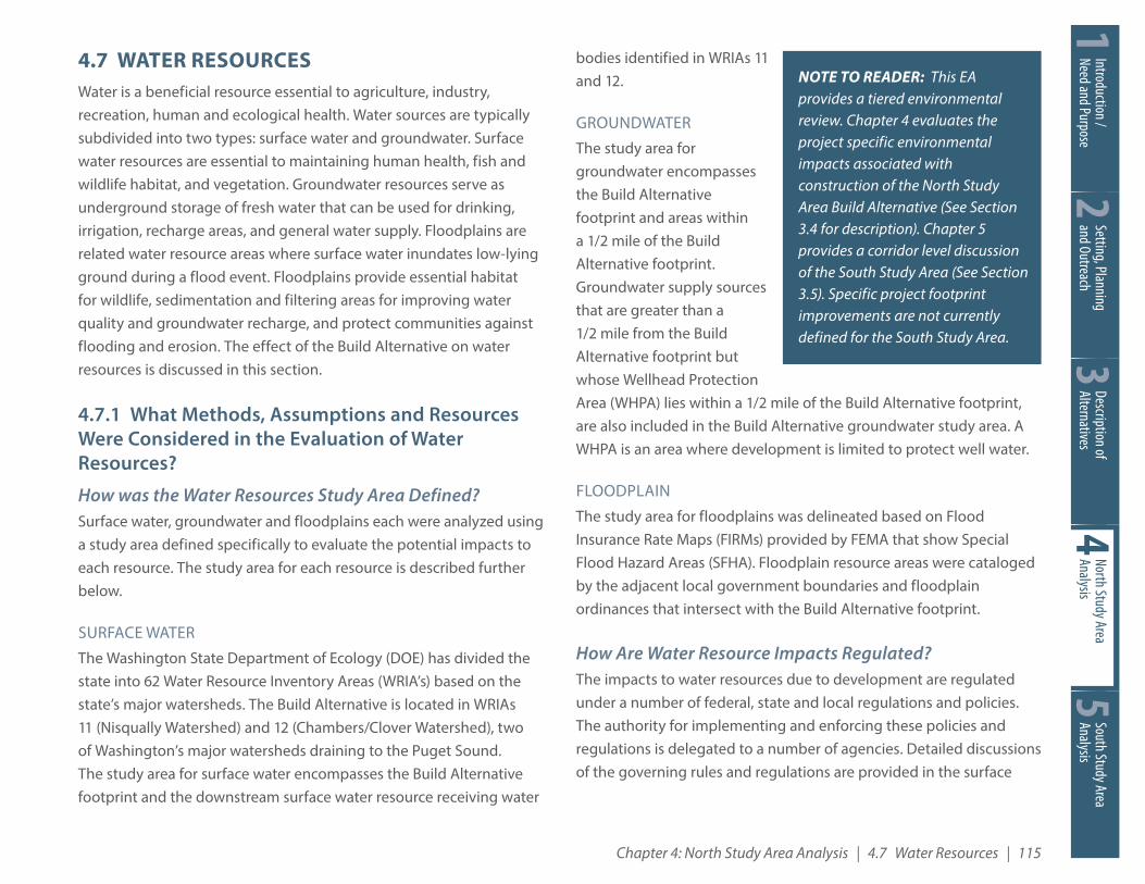
The study area is underlain by five productive natural aquifers and intervening aquitards (lower permeability confining units) with a total thickness of about 2,000 feet. The sequence of alternating aquifers and aquitards is underlain by bedrock. The groundwater resources that exist within the study area include the Central Pierce County Aquifer (CPCA) and the Chambers-Clover Creek Aquifer Recharge Area. Within the groundwater study area the aquifers provide 49 Class A and B water supply sources, composed of 48 production wells and one natural source, Sequalitchew Spring. Of the 49 water supply sources: 25 are groundwater supply wells (and sources) that are less than 100 feet deep, five are groundwater supply wells between 100 and 200 feet deep, and 19 are groundwater supply wells over 200 feet deep. Figure 4.7-2 shows the water supply sources and WHPAs within the groundwater resources study area.
Groundwater within the study area has been impacted by past industrial activities. Of 46 hazardous materials sites evaluated as part of the Hazardous Materials Discipline Report, two have groundwater issues that would need special consideration during construction to ensure they remain contained. The two are:
� The Fort Lewis Logistics Center. Listed on the National Priorities List (NPL) for a 2,500-foot-wide trichloroethylene (TCE) plume that extends over two miles from the Fort Lewis Logistics Center to the southeastern edge of American Lake. A pump-and-treat

34
5De
scrip
tion o
fAl
tern
ative
sNo
rth St
udy A
rea
Analy
sis2Se
tting
, Plan
ning
an
d Out
reac
h1In
trodu
ction
/Ne
ed an
d Pur
pose
118 | I-5 JBLM Vicinity Congestion Relief Project Environmental Assessment
Sout
h Stu
dy A
rea
Analy
sissystem has been operating since 1994 to treat the contaminated groundwater and infiltrate the treated groundwater.
� American Lake Gardens site. Former landfills associated with JBLM between the 1940s and 1970s that were found to contain halogenated organics including TCE and cis-1,2-dichloroethene (cis-1,2-DCE). A pump-and-treat system installed in 1994 has contained the contamination area to beneath the Whispering Fir Golf Course which currently overlays these former disposal sites.
FLOODPLAIN
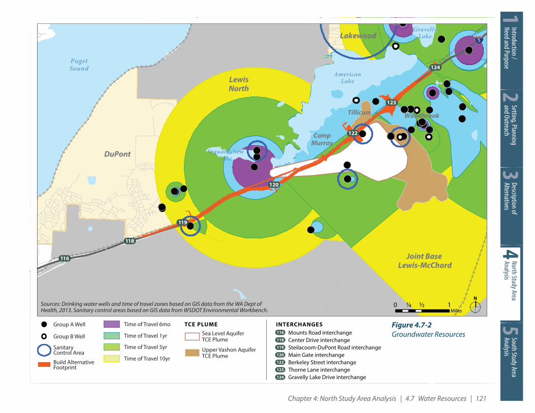
The mapped flood sources (streams and lakes) in the floodplain study area are Emerson Lake, Murray Creek, American Lake, Sequalitchew Creek/Lake and Bell Marsh. Floodplain resources within the study area are located within FEMA Special Flood Hazard Areas labeled as Zone A. Floodplains designated as Zone A are flooded by 100-year rainfall events. Non-Special Flood Hazard Areas are labelled as Zone B. Zone B floodplains are areas of shallow flooding less than one foot deep that occur during 100 year flood events, areas with contributing drainage areas less than one square mile, or areas protected by levees.
Floodplains in the study area include: Emerson Lake floodplains (Zone B) located near the Thorne Lane interchange at Exit 123 within the city of Lakewood limits; Murray Creek floodplain (Zone A) located south of the Berkeley Street interchange near Exit 122; the American Lake floodplain (Zone A) extending from Gravelly Lake Drive interchange near Exit 124 in the city of Lakewood to the Fort Lewis Main Gate of JBLM near Exit 120; and the Sequalitchew Creek floodplain (Zone A) located in the vicinity of Bell Marsh west of Steilacoom-DuPont Road within the city of DuPont. Figure 4.7-3 depicts the floodplains identified within the vicinity of the Build Alternative.
4.7.3 What Would Be the Impact of the No Build Alternative?The No Build Alternative assumes that the Build Alternative would not be constructed. Only routine maintenance and repair would occur in the study area through 2020. Therefore, the No Build Alternative would not result in any modifications to impervious surfaces or stormwater facilities. The No Build Alternative would not alter existing stormwater/surface water runoff patterns or the potential for spills or releases of materials which could contaminate surface and ground waters. Floodplain functions would also remain unaltered under the No Build Alternative as existing habitats and storage and conveyance of flood flows would not be modified. Thus, there would be no negative or beneficial effects under the No Build Alternative for surface water, groundwater and floodplain resources.
4.7.4 What Would Be the Long-Term Impact of the Build Alternative?Long-term and operational effects resulting from the Build Alternative may include increased runoff due to expansion of impervious areas, loss of floodplain storage, reduced channel and floodplain conveyance, or changes in infiltration capacity. These effects could increase river and stream channel flood flow rates and corresponding flood water surface elevations. The Build Alternative may also result in effects to wetland and stream habitat, impacts to non-federally listed aquatic species habitat, impacts to fish passage, and impacts to water quality as described in the Wetlands (4.8) and Fish, Wildlife, and Vegetation (4.9) sections in this chapter of this EA, as well as their respective discipline reports.
Construction and operation of the Build Alternative would result in an increase of stormwater related Pollution Generating Impervious Surfaces (PGIS) due to the addition of impervious roadway surfaces. Automotive-related pollutants, such as petroleum hydrocarbons

Chapter 4: North Study Area Analysis | 4.7 Water Resources | 119
34
5Description ofAlternatives
North Study Area Analysis
2Setting, Planning and Outreach
1Introduction /Need and Purpose
South Study AreaAnalysis
&118
&116
&120
&119
&124
&122
&123
LewisNorth
Joint Base Lewis-McChord
CampMurray
GravellyLake
AmericanLake
EmersonLake
HamerMarsh
McKayMarsh
BellMarsh
EdmondMarsh
Old FortLake
PugetSound
SequalitchewLake
DuPont
Lakewood
Sequalitch ew
Cree k
Murra y Cr ee k
TillicumWoodbrook
Figure 4.7-1Surface Water Resources
I-5 JBLM Congestion Relief Study Environmental Assessment
N0 ½ 1¼
Miles
INTERCHANGESMounts Road interchangeCenter Drive interchangeSteilacoom-DuPont Road interchangeMain Gate interchangeBerkeley Street interchangeThorne Lane interchangeGravelly Lake Drive interchange
&118&116
&119
&120
&124
&122
&123
Lake
Stream
Wetland Adjacent to Project
Build Alternative Footprint
WRIA Boundary
WRIA 1 2 : Chambers-Clover Watershed
WRIA
1 1: Nisqually Watershed
Outfall to Murray Creek/American Lake
Outfall to Stream 1
Outfall to Hamer Marsh
Outfall to Bell Marshand McKay Marsh
Outfall to RedSalmon Creek
Figure 4.7-1Surface Water Resources

34
5De
scrip
tion o
fAl
tern
ative
sNo
rth St
udy A
rea
Analy
sis2Se
tting
, Plan
ning
an
d Out
reac
h1In
trodu
ction
/Ne
ed an
d Pur
pose
120 | I-5 JBLM Vicinity Congestion Relief Project Environmental Assessment
Sout
h Stu
dy A
rea
Analy
sisand heavy metals, would deposit onto the roadway from daily traffic use. While PGIS would increase relative to existing conditions, both the existing and future PGIS would meet local, state and federal regulations for stormwater treatment to enhance water quality. Thus, surface water quality and quantity may result in positive benefits after construction of the Build Alternative due to implementation of measures that remove the additional petroleum hydrocarbons and heavy metals from surface water runoff.
The Build Alternative adds impervious surfaces to the study area that would increase the surface water runoff volumes. The increase in impervious surface and associated surface water runoff may decrease the ability for localized groundwater recharge, depending upon the Best Management Practices (BMPs) used for the Build Alternative. The impacts of increased impervious surfaces and increased surface water runoff would be offset by the construction of new and updated stormwater control facilities and BMPs that intercept surface water runoff, provide water quality treatment and infiltrate some or all of the additional flow. These facilities must meet the WSDOT’s National Pollutant Discharge Elimination System (NPDES) and State Waste Discharge Municipal Stormwater General Permit requirements. The Build Alternative would follow the WSDOT Highway Runoff Manual and the DOE Stormwater Management Manual for Western Washington, which specifies BMPs for stormwater runoff, to protect surface and groundwater resources. Thus, the Build Alternative is expected to have no significant negative impact to groundwater.
The Build Alternative would increase the water quality treatment by constructing new stormwater treatment areas. The proposal creates just over 32 acres of new PGIS. Stormwater planning performed to date indicates that proposed additions of stormwater facilities including ponds, swales, compost amended vegetated filter strips
(CAVFS) and other potential facilities may provide treatment for in excess of 59 acres of PGIS.
Permanent floodplain impacts stem from increased runoff rates, encroachments to the floodplain or floodway resulting from new roadway embankments, retaining walls or elevated structures in the floodplain. The placement of fill in the floodplain could cause a reduction in flood storage and conveyance capacity in the floodplain resources. The Build Alternative would place fill in the floodplain associated with Emerson Lake on the west side of I-5 in order to construct the new Thorne Lane interchange. The wetland/stream system in this location is depressional, created by fill associated with adjacent development, as well as general topography. The shared use path would cross Murray Creek on an elevated structure to minimize fill in the floodplain associated with Murray Creek. Floodplain mitigation will be required when the Build Alternative structures and fills cause either a rise in base flood elevation or a loss of storage and conveyance for flood hazard areas where floodplain regulations do not allow rise, loss of storage or conveyance.
4.7.5 What Would Be the Short-Term or Construction Impact of the Build Alternative?Under the Build Alternative, water quality of adjacent waterbodies could be temporarily affected by construction activities such as materials staging and equipment access, earthwork and grading, replacing or extending culverts, and building roadway lanes, ramps, retaining walls, and other structures.
Surface waters may be temporarily impacted by construction activities occurring within or directly adjacent to waterbodies which may increase turbidity and Total Suspended Solids (TSS) levels by either directly depositing sediments within surface waters or by increasing the amount of erosion that would occur during storm
Chapter 4: North Study Area Analysis | 4.7 Water Resources | 121
34
5Description ofAlternatives
North Study Area Analysis
2Setting, Planning and Outreach
1Introduction /Need and Purpose
South Study AreaAnalysis
&118
&116
&120
&119
&124
&122
&123
DuPont
LewisNorth
Lakewood
Joint Base Lewis-McChord
CampMurray
GravellyLake
AmericanLake
PugetSound
SequalitchewLake
Tillicum Woodbrook
Figure 4.7-2Groundwater Resources
I-5 JBLM Congestion Relief Study Environmental Assessment
N0 ½ 1¼
MilesSources: Drinking water wells and time of travel zones based on GIS data from the WA Dept of Health, 2013. Sanitary control areas based on GIS data from WSDOT Environmental Workbench.
SanitaryControl Area
Build AlternativeFootprint
Group A Well
Group B Well
Time of Travel 10yr
Time of Travel 5yr
Time of Travel 1yr
Time of Travel 6mo
Sea Level AquiferTCE Plume
TCE PLUME
Upper Vashon AquiferTCE Plume
INTERCHANGESMounts Road interchangeCenter Drive interchangeSteilacoom-DuPont Road interchangeMain Gate interchangeBerkeley Street interchangeThorne Lane interchangeGravelly Lake Drive interchange
&118&116
&119
&120
&124
&122
&123
Figure 4.7-2Groundwater Resources

34
5De
scrip
tion o
fAl
tern
ative
sNo
rth St
udy A
rea
Analy
sis2Se
tting
, Plan
ning
an
d Out
reac
h1In
trodu
ction
/Ne
ed an
d Pur
pose
122 | I-5 JBLM Vicinity Congestion Relief Project Environmental Assessment
Sout
h Stu
dy A
rea
Analy
sisevents. Construction equipment operating within the area may also spill fuel, hydraulic fluids, wet concrete or other pollutants. Construction excavation activities may increase the risk that these contaminants impact groundwater as they remove the portion of the unsaturated soils above the groundwater table, reducing the unsaturated zone thickness and decreasing the time it takes for a contaminant spill at the ground surface to reach groundwater.
Floodplain resources could also be impacted temporarily during the Build Alternative construction phase through vegetation removal, placement of construction materials, temporary excavation or stockpiling of soil in the floodplain, diversions and cofferdams, and equipment in the floodplain. Encroachments on the floodplain could temporarily reduce the flood storage capacity of the floodplain as well as the flood carrying capacity of the floodway, and contribute to construction-related pollutants in the floodplain that could affect aquatic and riparian habitats in the floodplain.
Dewatering of excavations and surface waterbodies in order to construct Build Alternative features may temporarily impact surface and groundwater quantity. Reductions in surface water quantity or lowering of the groundwater table may impact aquatic and riparian species that rely on these resources for their survival. Construction-related spills could result in pollutant transport into groundwater recharge areas.
4.7.6 How Can Impacts of the Build Alternative Be Minimized or Mitigated?
Surface Water CONSTRUCTION IMPACT MITIGATION
Effects to surface water resources during construction would be avoided, minimized, and mitigated through the development and implementation of Temporary Erosion and Sediment Control (TESC)
measures and Spill Prevention, Control and Countermeasures (SPCC) plans. A TESC plan would address the risk of erosion and BMPs to be implemented during construction. A SPCC plan would provide BMPs for preventing and controlling spills of hazardous materials. The Build Alternative will be subject to a Construction Stormwater General Permit that would require installation of BMP’s to prevent surface water pollution and contamination during construction. Monitoring of surface and groundwater quality will be part of a Stormwater Pollution Prevention Plan (SWPPP) and SPCC, as required by the Construction Stormwater General Permit. In addition, the requirements of the WSDOT Temporary Erosion and Sedimentation Control Manual (2014) would be followed.
BMPs include methods used to minimize or avoid construction effects to water quality such as sediment getting into streams. Examples of BMPs include installation of filter fabric fence downstream of all exposed slopes, around existing drainage inlets, and along river, stream, and drainage channels near work areas to prevent sediment-laden stormwater from entering streams. Both the TESC and SPCC plans would include performance standards and monitoring requirements based on state regulations, such as standards for Total Suspended Solids (TSS) levels in stormwater discharged from construction staging and work areas. Construction of the Build Alternative would require compliance with approved TESC and SPCC plans that would be based on these performance standards.
Other measures to avoid or minimize impacts during construction of the Build Alternative include the development and implementation of diversion and dewatering plans, aquatic life relocation and protection plans, and a Concrete Containment and Disposal Plan (CCDP) for handling and managing concrete onsite, and other permit conditions. These plans and permits regulate construction activities on land and
Chapter 4: North Study Area Analysis | 4.7 Water Resources | 123
34
5Description ofAlternatives
North Study Area Analysis
2Setting, Planning and Outreach
1Introduction /Need and Purpose
South Study AreaAnalysis
&118
&116
&120
&119
&124
&122
&123
LewisNorth
Joint Base Lewis-McChord
CampMurray
EmersonLake
HamerMarsh
McKayMarsh
BellMarsh
EdmondMarsh
Old FortLake
PugetSound
DuPont
Lakewood
Sequalitch ew
Cree k
Murra y Cr ee k
GravellyLake
AmericanLake
SequalitchewLake
Figure 4.7-3Floodplains
I-5 JBLM Congestion Relief Study Environmental Assessment
N0 ½ 1¼
Miles
INTERCHANGESMounts Road interchangeCenter Drive interchangeSteilacoom-DuPont Road interchangeMain Gate interchangeBerkeley Street interchangeThorne Lane interchangeGravelly Lake Drive interchange
&118&116
&119
&120
&124
&122
&123
Build Alternative Footprint
Lake
500-Year Floodplain
100-Year Floodplain (SFHA)*
TillicumWoodbrook
Figure 4.7-3Floodplains

34
5De
scrip
tion o
fAl
tern
ative
sNo
rth St
udy A
rea
Analy
sis2Se
tting
, Plan
ning
an
d Out
reac
h1In
trodu
ction
/Ne
ed an
d Pur
pose
124 | I-5 JBLM Vicinity Congestion Relief Project Environmental Assessment
Sout
h Stu
dy A
rea
Analy
sisin the water to prevent or reduce temporary degradation of water quality or impacts to aquatic organisms from construction activities.
LONG-TERM IMPACT MITIGATION
The increase in impervious surfaces and associated runoff would be mitigated by implementing the stormwater management controls required by the Highway Runoff Manual (HRM). These facilities will be of two variations, those providing flow control and those providing water quality control. Most potential BMPs will provide both flow and water quality control. The selection of BMP’s would follow established criteria specified in the HRM and include designs like CAVFS, continuous inflow compost amended biofiltration swales (CICABS), swales, and infiltration ponds.
Groundwater Construction impacts to groundwater resources would be mitigated through the use of BMPs and compliance with applicable regulations and permit conditions, including implementation of SPCC as described above. These measures aim to reduce chances of contaminants entering the groundwater system. Mitigation measures may also include decommissioning four monitoring wells that are located within the Build Alternative footprint. Risk of contamination of these wells is likely minimal, but if the well seal is in poor condition or suffers damage during construction, the risk of contamination from spills would be greatly increased. Abandonment of the wells following the procedures required by DOE would permanently seal the well and prevent the risk of contamination. If abandonment is not feasible due to well owner needs, then these wells would be protected in place. Dewatering operations for construction may also have varying types of discharges that will require treatment, similar to construction surface water BMPs.
FloodplainsShort-term effects on floodplains would be reduced through design specifications and regulatory permit conditions that require the contractor to provide mitigation measures to reduce floodplain effects and elevated flood risks. Example mitigation measures related to floodplain effects include working during dry seasons and avoiding placement of construction materials within the floodplain and floodway. Construction of the Build Alternative includes increases to impervious surface and potential encroachment into the floodplain and floodway. This would require mitigation in the form of compensatory flood storage. The contractor may also be required to develop and implement diversion and dewatering plans to manage surface water flows during flood periods, and a habitat protection plan, or fish relocation plan to protect aquatic resources. These actions would mitigate effects on floodplain storage capacity during construction periods and associated potential impacts to wildlife. Complete avoidance or mitigation of floodplain effects during construction is not likely feasible, and some minor effects may be incurred.
4.7.7 Would There Be Any Unavoidable Adverse Impacts from the Build Alternative?Risks to surface water and groundwater posed by construction of the Build Alternative can be avoided through design and controlled through the use of BMPs. Therefore, no unavoidable direct or indirect adverse effects are expected to these resources. However, some of the floodplain functions in the system may be unavoidably impacted due to construction of Build Alternative features within the floodplain and floodway at the location of the new Thorne Lane interchange and the proposed shared use path.