Embed Size (px)
Citation preview
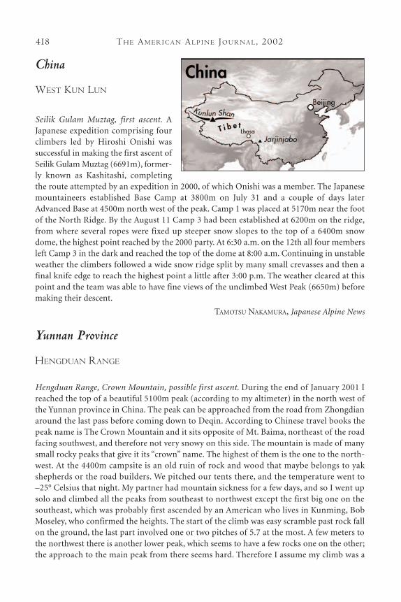
China
WEST KUN LUN
Seilik Gulam Muztag, first ascent. AJapanese expedition comprising fourclimbers led by Hiroshi Onishi was successful in making the first ascent ofSeilik Gulam Muztag (6691m), former-ly known as Kashitashi, completingthe route attempted by an expedition in 2000, of which Onishi was a member. The Japanesemountaineers established Base Camp at 3800m on July 31 and a couple of days laterAdvanced Base at 4500m north west of the peak. Camp 1 was placed at 5170m near the footof the North Ridge. By the August 11 Camp 3 had been established at 6200m on the ridge,from where several ropes were fixed up steeper snow slopes to the top of a 6400m snowdome, the highest point reached by the 2000 party. At 6:30 a.m. on the 12th all four membersleft Camp 3 in the dark and reached the top of the dome at 8:00 a.m. Continuing in unstableweather the climbers followed a wide snow ridge split by many small crevasses and then afinal knife edge to reach the highest point a little after 3:00 p.m. The weather cleared at thispoint and the team was able to have fine views of the unclimbed West Peak (6650m) beforemaking their descent.
TAMOTSU NAKAMURA, Japanese Alpine News
Yunnan Province
HENGDUAN RANGE
Hengduan Range, Crown Mountain, possible first ascent. During the end of January 2001 Ireached the top of a beautiful 5100m peak (according to my altimeter) in the north west ofthe Yunnan province in China. The peak can be approached from the road from Zhongdianaround the last pass before coming down to Deqin. According to Chinese travel books thepeak name is The Crown Mountain and it sits opposite of Mt. Baima, northeast of the roadfacing southwest, and therefore not very snowy on this side. The mountain is made of manysmall rocky peaks that give it its “crown” name. The highest of them is the one to the north-west. At the 4400m campsite is an old ruin of rock and wood that maybe belongs to yakshepherds or the road builders. We pitched our tents there, and the temperature went to–25° Celsius that night. My partner had mountain sickness for a few days, and so I went upsolo and climbed all the peaks from southeast to northwest except the first big one on thesoutheast, which was probably first ascended by an American who lives in Kunming, BobMoseley, who confirmed the heights. The start of the climb was easy scramble past rock fallon the ground, the last part involved one or two pitches of 5.7 at the most. A few meters tothe northwest there is another lower peak, which seems to have a few rocks one on the other;the approach to the main peak from there seems hard. Therefore I assume my climb was a
TH E AM E R I C A N AL P I N E JO U R NA L, 2002418
first ascent. The entire climb down was easier in a 5.5 chimney. The climb takes a few hours.Not far away sits the highest peak in Yunnan, the sacred unclimbed Meili peak, which canbe seen from Crown Mountain.
ALON HOD, Israel
SICHUAN
Jarjinjabo Range, first ascent of unnamed rock tower. Four Japanese climbers, Eiji Daigo, YurikoKowaka, Naoki Ohuchi, and Taizo Yoshida, made the first ascent of an unnamed granite tower inthe Jarjinjabo Massif above Zhopu Pasture. This region of West Sichuan lies close to the border(Yangste River) with Tibet and approximately 65 km northeast of Batang on the Sichuan-TibetHighway. The team established base camp on July 25 at 4050m on the Zhopu Pasture and on the26th set up an advanced camp at ca 4700m below the tower, after making a non-glaciatedapproach. On the 27th they fixed the first 100 meters of the south pillar in three pitches and aftertwo days of rain recommenced by climbing 10 pitches and bivouacking. The following day, the31st, they completed a further three pitches to the summit and descended. The 320-meter-high wall(480 meters of climbing) gave maximum difficulties of 5.10a and A1. Although nearly 70 percentof the route followed good cracks, the team used more aid than expected due to the heavy rain.
TAMOTSU NAKAMURA, Japanese Alpine NewS
Tibet
Gurla Mandata, ascent. Japanese climbers,Masakazu Okunda and Susumu Yamada,together with a high altitude porter, climbedthis 7694m peak in Western Tibet via theOriginal Route up the West Ridge approachedfrom the north. The summit, a.k.a.Naimona’nyi, was reached on September 25.
TAMOTSU NAKAMURA, Japanese Alpine News
Yangra Kangri, attempt on a new route. The highest summit in the Ganesh Himal lies on theNepal-Tibet border and is referred to as Yangra Kangri (in Tibet) or Ganesh I (in Nepal). The7429m peak was climbed on October 24, 1955 from the Nepalese side by Eric Guachet, ClaudeKogan, and Raymond Lambert, but since then nobody else has reached the top. In 1987 a jointexpedition between The Himalayan Association of Japan and The Tibet MountaineeringAssociation succeeded in climbing Labuche Kang (7367m), west of Cho Oyu. In spring 1995,Mr. Cheng Tianliang, the Tibetan leader of that expedition, suggested a 10th anniversary jointexpedition, the target being the north side of Yangra Kangri in 1997. As the area around thepeak had not yet been opened to foreigners, I lost no time in replying that the HAJ agreed tohis suggestion.
I organized a reconnaissance and at the end of September 1996, joined 45 year old Gaya,
419CL I M B S A N D EX P E D I T I O N S : CH I NA A N D TI B E T
TH E AM E R I C A N AL P I N E JO U R NA L, 2002420
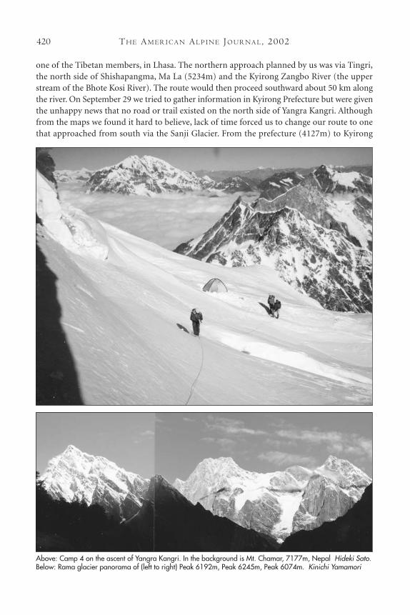
one of the Tibetan members, in Lhasa. The northern approach planned by us was via Tingri,the north side of Shishapangma, Ma La (5234m) and the Kyirong Zangbo River (the upperstream of the Bhote Kosi River). The route would then proceed southward about 50 km alongthe river. On September 29 we tried to gather information in Kyirong Prefecture but were giventhe unhappy news that no road or trail existed on the north side of Yangra Kangri. Althoughfrom the maps we found it hard to believe, lack of time forced us to change our route to onethat approached from south via the Sanji Glacier. From the prefecture (4127m) to Kyirong
Above: Camp 4 on the ascent of Yangra Kangri. In the background is Mt. Chamar, 7177m, Nepal Hideki Sato.Below: Rama glacier panorama of (left to right) Peak 6192m, Peak 6245m, Peak 6074m. Kinichi Yamamori
CL I M B S A N D EX P E D I T I O N S : TI B E T 421
District (2795m), we had a 75km jeep ride, driving on a road made in the bottom of the river.In a few hours we had moved from desert area to forest. At 10:00 p.m. some local policemencame to us and took our passports away. Next day we visited the border police office, where theytold us not to proceed. “Why?” we asked, “we have permission.” “The Chinese map is notauthentic,” they replied. After an hour’s discussion, they permitted us to go, saying “We will keepyour passport until you come back. Don’t take any photographs.”
Gaya and I hired four porters and left Kyirong District. We descended southward alongthe Kyirong Zanbo River, where many laborers were making a roadway. After a five-hour walkwe reached a point (2026m) where we had to cross the river via a bamboo basket hung from asingle wire rope. Shortly after, we reached Jangzon (2400m), where we stayed the night. Nextday we camped early at 3480m close to the river, from where Gaya reached the Lado La(4632m). The entrance to the Sanji Glacier was obscured due to rain, and persistent bad weathermeant that we were subsequently prevented from seeing the south face of Yangra Kangri.We had no alternative but to go back, arriving in Kyirong District on October 5.
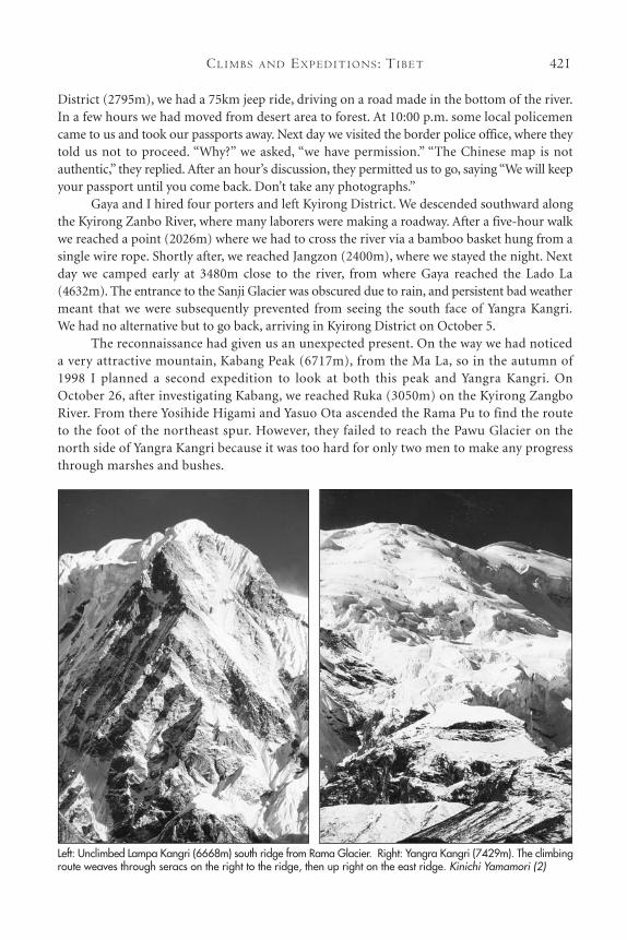
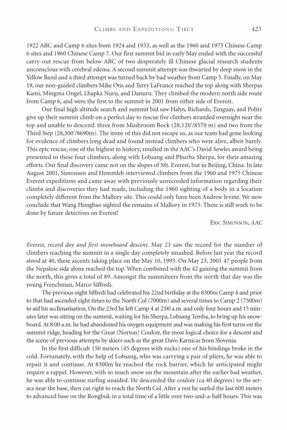
The reconnaissance had given us an unexpected present. On the way we had noticeda very attractive mountain, Kabang Peak (6717m), from the Ma La, so in the autumn of1998 I planned a second expedition to look at both this peak and Yangra Kangri. OnOctober 26, after investigating Kabang, we reached Ruka (3050m) on the Kyirong ZangboRiver. From there Yosihide Higami and Yasuo Ota ascended the Rama Pu to find the routeto the foot of the northeast spur. However, they failed to reach the Pawu Glacier on thenorth side of Yangra Kangri because it was too hard for only two men to make any progressthrough marshes and bushes.
Left: Unclimbed Lampa Kangri (6668m) south ridge from Rama Glacier. Right: Yangra Kangri (7429m). The climbingroute weaves through seracs on the right to the ridge, then up right on the east ridge. Kinichi Yamamori (2)
TH E AM E R I C A N AL P I N E JO U R NA L, 2002422
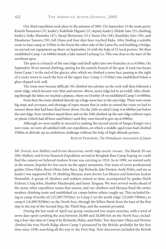
Our third expedition took place in the autumn of 2001. On September 15 the main party:Kinichi Yamamori (57, leader); Yoshihide Higami (57, deputy leader); Hideki Sato (53, climbingleader); Seiko Mantoku (47); Yasuji Moriyama (51); Yasuo Ota (48); Kunihiko Sato (58), andMasakatsu Tamura (59), left Lhasa and four days later reached Ruka. After finding a suitableroute to base camp at 3350m in the forest the other side of the Lama Pu, and building a bridge,we moved our equipment up there on September 24 with the help of 51 local porters. We thenestablished Camp 1 at 4400m beside a lake named Lachang Co. This was close to the start of thenortheast spur.
The spur is a branch of the east ridge and itself splits into two branches at ca 6100m. OnSeptember 30 we started climbing, aiming for the easterly branch of the spur. It took two hoursfrom Camp 1 to the end of the glacier, after which we climbed a snow face, passing to the rightof a rocky tower to reach the foot of the upper face. Camp 2 (5350m) was established below aglass-shaped rock wall.
The route now became difficult. We climbed two pitches on the rock wall then followed asnow ridge, which became very thin and narrow. Above, more ridge led to an icefall. After climb-ing through the latter, we reached a plateau, where on October 18 we established Camp 3 at 6000m.
From here the route climbed directly up a huge snow face to the east ridge. There were manybig steps and crevasses, and shortage of ropes meant that in order to extend the route we had toremove those that had been fixed lower down. On the 24th we sited Camp 4 at 6860m just belowthe east ridge. Four members stayed there and on the 26th climbed up the east ridge without ropesor pitons (which had all been used below) until they were forced to give up at 6900m.
Although we were unable to succeed in making the second ascent of Yangra Kangri via anew route, we were all satisfied with our expedition, on which a middle-aged team had climbed2500m at altitude up an ambitious challenge without the help of high altitude porters.
KINICHI YAMAMORI, The Himalayan Association of Japan
Mt. Everest, new Mallory and Irvine discoveries, north ridge ascent, rescues. On March 20 our2001 Mallory and Irvine Research Expedition arrived at Rongbuk Base Camp hoping we couldfind the camera we believed Andrew Irvine was carrying in 1924. As in 1999, we started earlyin the season, hopeful for less snow on the upper mountain. Our team of seven professionalguides (Dave Hahn, Brent Okita, John Race, Tap Richards, Jake Norton, Andy Politz, and me asleader) was supported by 19 climbing Sherpas, team doctor Lee Meyers and historian JochenHemmleb. A group of climbers and trekkers joined us later, accompanied by guides HeidiEichner, Craig John, Heather Macdonald, and Jason Tanguay. We were several weeks ahead ofthe many other expedition teams that season, and our climbers and Sherpas fixed the entiremodern climbing route and established six camps before others caught up. This included fix-ing to camp 4/north col (23,200'/7070m), to Camp 5 on the north ridge (25,600'/7800m), tocamp 6 (26,900'/8200m) on the North Face, through the Yellow Band, from the base of the firststep to the top of the Second Step, the Third Step, and the summit pyramid.
During the last week of April our group conducted two major searches, with a total ofseven days spent combing the area between 26,000 and 28,000 feet on the North Face, includ-ing a four-day stint at Camp 6 by Richards, Hahn, and Politz. Two days later Okita and Nortonclimbed the true North Ridge above Camp 5 pioneered by the British, probably for the firsttime since 1938, searching all the way to the First Step. New discoveries included the British
CL I M B S A N D EX P E D I T I O N S : TI B E T 423
1922 ABC and Camp 6 sites from 1924 and 1933, as well as the 1960 and 1975 Chinese Camp6 sites and 1960 Chinese Camp 7. Our first summit bid in early May ended with the successfulcarry-out rescue from below ABC of two desperately ill Chinese glacial research studentsunconscious with cerebral edema. A second summit attempt was thwarted by deep snow in theYellow Band and a third attempt was turned back by bad weather from Camp 5. Finally, on May19, our non-guided climbers Mike Otis and Terry LaFrance reached the top along with SherpasKami, Mingma Ongel, Lhapka Nuru, and Danuru. They climbed the modern north side routefrom Camp 6, and were the first to the summit in 2001 from either side of Everest.
Our final high altitude search and summit bid saw Hahn, Richards, Tanguay, and Politzgive up their summit climb on a perfect day to rescue five climbers stranded overnight near thetop and unable to descend: three from Mushroom Rock (28,120'/8570 m) and two from theThird Step (28,500'/8690m). The irony of this did not escape us, as our team had gone lookingfor evidence of climbers long dead and found instead climbers who were alive, albeit barely.This epic rescue, one of the highest in history, resulted in the AAC’s David Sowles award beingpresented to these four climbers, along with Lobsang and Phurba Sherpa, for their amazingefforts. Our final discovery came not on the slopes of Mt. Everest, but in Beijing, China. In lateAugust 2001, Simonson and Hemmleb interviewed climbers from the 1960 and 1975 ChineseEverest expeditions and came away with previously unrecorded information regarding theirclimbs and discoveries they had made, including the 1960 sighting of a body in a location completely different from the Mallory site. This could only have been Andrew Irvine. We nowconclude that Wang Hongbao sighted the remains of Mallory in 1975. There is still work to bedone by future detectives on Everest!
ERIC SIMONSON, AAC
Everest, record day and first snowboard descent. May 23 saw the record for the number ofclimbers reaching the summit in a single day completely smashed. Before last year the recordstood at 40, these ascents taking place on the May 10, 1993. On May 23, 2001 47 people fromthe Nepalese side alone reached the top. When combined with the 42 gaining the summit fromthe north, this gives a total of 89. Amongst the summiteers from the north that day was theyoung Frenchman, Marco Siffredi.
The previous night Siffredi had celebrated his 22nd birthday at the 8300m Camp 4 and priorto that had ascended eight times to the North Col (7000m) and several times to Camp 2 (7500m)to aid his acclimatisation. On the 23rd he left Camp 4 at 2:00 a.m. and only four hours and 15 min-utes later was sitting on the summit, waiting for his Sherpa, Lobsang Temba, to bring up his snow-board. At 8:00 a.m. he had abandoned his oxygen equipment and was making his first turns on thesummit ridge, heading for the Great (Norton) Couloir, the most logical choice for a descent andthe scene of previous attempts by skiers such as the great Davo Karnicar from Slovenia.
In the first difficult 150 meters (45 degrees with rocks) one of his bindings broke in thecold. Fortunately, with the help of Lobsang, who was carrying a pair of pliers, he was able torepair it and continue. At 8300m he reached the rock barrier, which he anticipated mightrequire a rappel. However, with so much snow on the mountain after the earlier bad weather,he was able to continue surfing unaided. He descended the couloir (ca 40 degrees) to the ser-acs near the base, then cut right to reach the North Col. After a rest he surfed the last 600 metersto advanced base on the Rongbuk in a total time of a little over two-and-a-half hours. This was
TH E AM E R I C A N AL P I N E JO U R NA L, 2002424
not only the first complete snowboard descent of Everest, but the first complete descent of theTibetan side of the mountain by either ski or surf.
MOUNTAIN INFO, High Mountain Sports
Everest, first descent by paraglider. First to reach the summit on May 22 were Bertrand“Zébulon” Roche and his wife Clair Bernier-Roche. This was the second time for Bertrandon the summit of Everest. In October 1990, when he was 17 years old, he became theyoungest non-Nepalese to climb Everest, a record which stills stands to this day. He reachedthe top with his father, the guide Jean-Noël Roche, the ascent also being the first time afather and son had reached the summit together. Now he is a guide and with his wife ownsa paragliding school, where she is an instructor (and also three-times World female cham-pion). They brought their tandem paraglider to the top and when they soared overhead todescend from the summit directly to advanced base at 6400m in just 10 minutes, peoplebelow were amazed and fascinated by this spectacular sight. It was the first complete descentof Everest by paraglider.
ELIZABETH HAWLEY
Everest, East (Fantasy) Ridge attempt. The only expedition that did not attempt the standard Everestroutes on the north and south side during the spring was a team of 10 Indian climbers and fiveNepalese Sherpas led by Santosh Yadav, the first woman to climb Everest twice. This expedition madea brave attempt on the unclimbed east ridge, rising steeply from the middle of the east (Kangshung)face. The only other team to have tried this line was a Japanese expedition in 1991, which abandonedits attempt at 6400m because of the extremely difficult nature of the terrain and the dangerous ava-lanche potential. Yadav took large quantities of rope and equipment, and before going to themountain said “I am 100 percent sure about my climbers and my equipment.” She could deter-mine these factors but not the constant snow fall. With not a single full day of good weatherthroughout the expedition period from April 12 to May 24, and white out conditions even at basecamp, with frequent avalanches and very few safe sites to establish camps beyond the team’s highpoint of 6900m, the expedition abandoned its attempt and went home, reportedly leaving all theropes in place. Yadav said she was determined to try this route again.
ELIZABETH HAWLEY
Everest, post monsoon attempts. In complete contrast to the spring, only three expeditions attempt-ed Everest from the north. All were unsuccessful and no one managed to climb higher than7800m. Two teams were on the standard North Col-north ridge route, including the Americandouble amputee, Ed Hommer. The third expedition was attempting the rarely-climbed east(Kangshung) face. Five climbing members from Hungary under the leadership of David Kleinwere attempting the 1988 Anglo-American Route. Their maximum altitude was just 6300m,which they reached after more than four weeks on the mountain. They finally abandoned theirattempt after many days of heavy snowfall followed by days of dangerous avalanches down theextremely steep face. They would climb a little, snow would fall heavily, they would retreat to asafe camp, wait two days for the avalanches to stop, go back up again and then the same pattern
CL I M B S A N D EX P E D I T I O N S : TI B E T 425
would repeat itself. Luckily none were killed or even seriously injured, though Klein was brieflyknocked unconscious by stone fall and two other members were carried inside their tent 250meters down to the bottom of the face, when an avalanche struck their camp.
ELIZABETH HAWLEY
For information on Everest from the south side, see the Nepal reports.
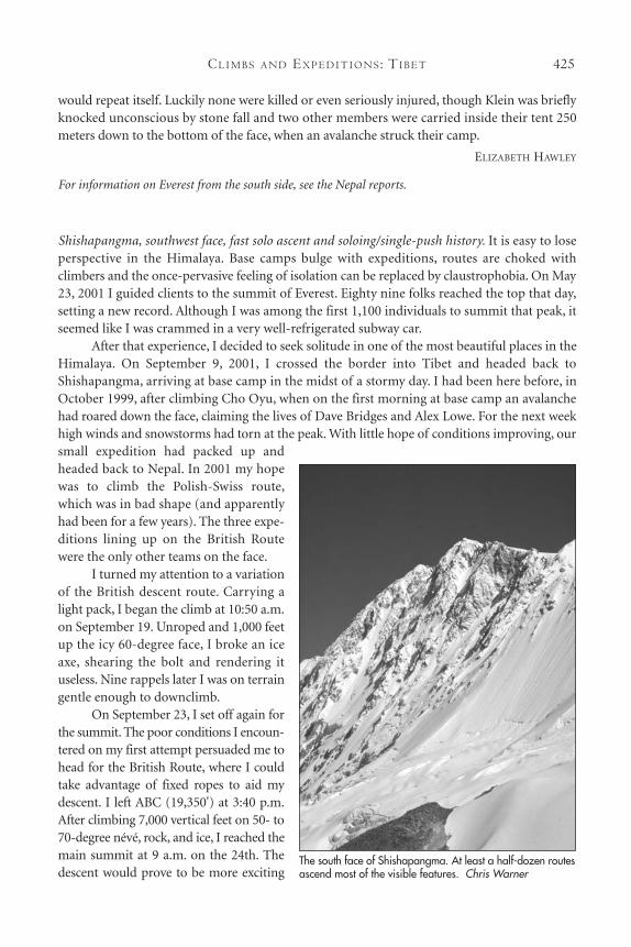
Shishapangma, southwest face, fast solo ascent and soloing/single-push history. It is easy to loseperspective in the Himalaya. Base camps bulge with expeditions, routes are choked withclimbers and the once-pervasive feeling of isolation can be replaced by claustrophobia. On May23, 2001 I guided clients to the summit of Everest. Eighty nine folks reached the top that day,setting a new record. Although I was among the first 1,100 individuals to summit that peak, itseemed like I was crammed in a very well-refrigerated subway car.
After that experience, I decided to seek solitude in one of the most beautiful places in theHimalaya. On September 9, 2001, I crossed the border into Tibet and headed back toShishapangma, arriving at base camp in the midst of a stormy day. I had been here before, inOctober 1999, after climbing Cho Oyu, when on the first morning at base camp an avalanchehad roared down the face, claiming the lives of Dave Bridges and Alex Lowe. For the next weekhigh winds and snowstorms had torn at the peak. With little hope of conditions improving, oursmall expedition had packed up andheaded back to Nepal. In 2001 my hopewas to climb the Polish-Swiss route,which was in bad shape (and apparentlyhad been for a few years). The three expe-ditions lining up on the British Routewere the only other teams on the face.
I turned my attention to a variationof the British descent route. Carrying alight pack, I began the climb at 10:50 a.m.on September 19. Unroped and 1,000 feetup the icy 60-degree face, I broke an iceaxe, shearing the bolt and rendering ituseless. Nine rappels later I was on terraingentle enough to downclimb.
On September 23, I set off again forthe summit. The poor conditions I encoun-tered on my first attempt persuaded me tohead for the British Route, where I couldtake advantage of fixed ropes to aid mydescent. I left ABC (19,350') at 3:40 p.m.After climbing 7,000 vertical feet on 50- to70-degree névé, rock, and ice, I reached themain summit at 9 a.m. on the 24th. Thedescent would prove to be more exciting
The south face of Shishapangma. At least a half-dozen routesascend most of the visible features. Chris Warner
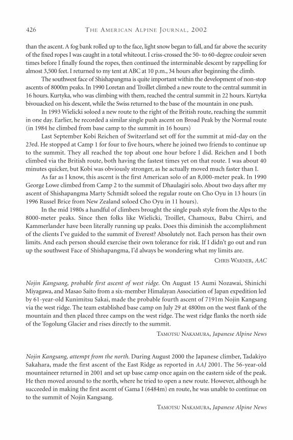
TH E AM E R I C A N AL P I N E JO U R NA L, 2002426
than the ascent. A fog bank rolled up to the face, light snow began to fall, and far above the securityof the fixed ropes I was caught in a total whiteout. I criss-crossed the 50- to 60-degree couloir seventimes before I finally found the ropes, then continued the interminable descent by rappelling foralmost 3,500 feet. I returned to my tent at ABC at 10 p.m., 34 hours after beginning the climb.
The southwest face of Shishapangma is quite important within the development of non-stopascents of 8000m peaks. In 1990 Loretan and Troillet climbed a new route to the central summit in16 hours. Kurtyka, who was climbing with them, reached the central summit in 22 hours. Kurtykabivouacked on his descent, while the Swiss returned to the base of the mountain in one push.
In 1993 Wielicki soloed a new route to the right of the British route, reaching the summitin one day. Earlier, he recorded a similar single push ascent on Broad Peak by the Normal route(in 1984 he climbed from base camp to the summit in 16 hours)
Last September Kobi Reichen of Switzerland set off for the summit at mid-day on the23rd. He stopped at Camp 1 for four to five hours, where he joined two friends to continue upto the summit. They all reached the top about one hour before I did. Reichen and I bothclimbed via the British route, both having the fastest times yet on that route. I was about 40minutes quicker, but Kobi was obviously stronger, as he actually moved much faster than I.
As far as I know, this ascent is the first American solo of an 8,000-meter peak. In 1990George Lowe climbed from Camp 2 to the summit of Dhaulagiri solo. About two days after myascent of Shishapangma Marty Schmidt soloed the regular route on Cho Oyu in 13 hours (in1996 Russel Brice from New Zealand soloed Cho Oyu in 11 hours).
In the mid 1980s a handful of climbers brought the single push style from the Alps to the8000-meter peaks. Since then folks like Wielicki, Troillet, Chamoux, Babu Chirri, andKammerlander have been literally running up peaks. Does this diminish the accomplishmentof the clients I’ve guided to the summit of Everest? Absolutely not. Each person has their ownlimits. And each person should exercise their own tolerance for risk. If I didn’t go out and runup the southwest Face of Shishapangma, I’d always be wondering what my limits are.
CHRIS WARNER, AAC
Nojin Kangsang, probable first ascent of west ridge. On August 15 Aumi Nozawai, ShinichiMiyagawa, and Masao Saito from a six-member Himalayan Association of Japan expedition ledby 61-year-old Kunimitsu Sakai, made the probable fourth ascent of 7191m Nojin Kangsangvia the west ridge. The team established base camp on July 29 at 4800m on the west flank of themountain and then placed three camps on the west ridge. The west ridge flanks the north sideof the Togolung Glacier and rises directly to the summit.
TAMOTSU NAKAMURA, Japanese Alpine News
Nojin Kangsang, attempt from the north. During August 2000 the Japanese climber, TadakiyoSakahara, made the first ascent of the East Ridge as reported in AAJ 2001. The 56-year-oldmountaineer returned in 2001 and set up base camp once again on the eastern side of the peak.He then moved around to the north, where he tried to open a new route. However, although hesucceeded in making the first ascent of Gama I (6484m) en route, he was unable to continue onto the summit of Nojin Kangsang.
TAMOTSU NAKAMURA, Japanese Alpine News
CL I M B S A N D EX P E D I T I O N S : TI B E T 427
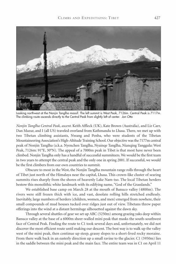
Nonjin Tanglha Central Peak, ascent. Keith Affleck (UK), Kate Brown (Australia), and Liz Carr,Dan Mazur, and I (all US) traveled overland from Kathmandu to Lhasa. There, we met up withtwo Tibetan climbing assistants, Nwang and Penba, who were students of the TibetanMountaineering Association’s High-Altitude Training School. Our objective was the 7177m centralpeak of Nonjin Tanglha (a.k.a. Nyenchen Tanglha, Nyainqe Tanglha, Nianqing Tanggula: WestPeak, 7126m: 91°E, 30°N). The appeal of a 7000m peak in Tibet is that most have never beenclimbed. Nonjin Tanglha only has a handful of successful summiteers. We would be the first teamin two years to attempt the central peak and the only one in spring 2001. If successful, we wouldbe the first climbers from our own countries to summit.
Obscure to most in the West, the Nonjin Tanglha mountain range rolls through the heartof Tibet just north of the Himalaya near the capital, Lhasa. This crown-like cluster of searingsummits rises sharply from the shores of heavenly Lake Nam-tso. The local Tibetan herdersbestow this monolithic white landmark with its edifying name, “God of the Grasslands.”
We established base camp on March 28 at the mouth of Banuco valley (4800m). Therivers were still frozen thick with ice, and vast, desolate rolling hills stretched endlessly.Inevitably, large numbers of herders (children, women, and men) emerged from nowhere, theirsmall compounds of mud houses tucked over ridges just out of view. Tibetans threw paperofferings into the wind at a distant hermitage silhouetted against the dawn sky.
Through several shuttles of gear we set up ABC (5250m) among grazing yaks deep withinBanuco valley at the base of a 6000m sheer-walled mini peak that masks the south-southwestface of Central Peak. Finding the route to C1 took several days and, unfortunately, we did notdiscover the most efficient route until making our descent. The best way is to walk up the valleywest of the mini peak, then continue up steep, grassy slopes to a short-lived rocky moraine.From there walk back in an easterly direction up a small ravine to the glacier. C1 (5950m) liesin the saddle between the mini peak and the main face. The entire team was in C1 on April 11
Looking northwest at the Nonjin Tanglha massif. The left summit is West Peak, 7126m. Central Peak is 7117m. The climbing route ascends directly to the Central Peak from slightly left of center. Jon Otto
TH E AM E R I C A N AL P I N E JO U R NA L, 2002428
having reached this point via amuch more arduous traverse of themini peak.
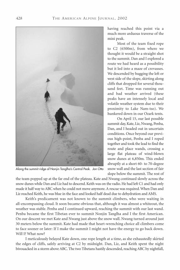
Most of the team fixed ropeto C2 (6500m), from where wethought it would be a straight shotto the summit. Dan and I explored aroute we had heard as a possibilitybut it led into a maze of crevasses.We descended by hugging the left orwest side of the slope, skirting alongcliffs that dropped for several thou-sand feet. Time was running outand bad weather arrived (thesepeaks have an intensely local andvolatile weather system due to theirproximity to Lake Nam-tso). Wehunkered down in our Ozark tents.
On April 15, our last possiblesummit day, Kate, Liz, Nwang, Penba,Dan, and I headed out in uncertainconditions. Once beyond our previ-ous high-point, Penba and I ropedtogether and took the lead to find theroute and place wands, crossing alarge flat plateau of wind-blownsnow dunes at 6,850m. This endedabruptly at a short 60- to 70-degreesnow wall and the last section of fairslope below the summit. The rest of
the team popped up at the far end of the plateau. Kate and Nwang continued slowly across thesnow dunes while Dan and Liz had to descend. Keith was on the radio. He had left C1 and had onlymade it half way to ABC when he could not move anymore. A rescue was required. When Dan andLiz reached Keith, he was blue in the face and looked half dead due to dehydration and AMS.
Keith’s predicament was not known to the summit climbers, who were waiting in all-encompassing cloud. It soon became obvious that, although it was almost a whiteout, theweather was stable. Penba and I continued upward, reaching the summit with our last wand.Penba became the first Tibetan ever to summit Nonjin Tanglha and I the first American.On our descent we met Kate and Nwang just above the snow wall. Nwang turned around just30 meters below the summit. Kate had made that heart-wrenching choice all climbers cometo face sooner or later: If I make the summit I might not have the energy to go back down.Will I? What now?
I meticulously belayed Kate down, one rope length at a time, as she exhaustedly skirtedthe edges of cliffs, safely arriving at C2 by midnight. Dan, Liz, and Keith spent the nightbivouacked in a storm above ABC. The two Tibetans hastily descended, reaching ABC by nightfall,
Along the summit ridge of Nonjin Tanglha’s Central Peak. Jon Otto
CL I M B S A N D EX P E D I T I O N S : TI B E T 429
having cleared a huge pack of gear off the mountain. As we reached base camp the followingday our jeeps were waiting to drive us back to Lhasa.
JON OTTO, AAC
Editor’s Note: The 7126m West Peak was first climbed in 1986 by three members of Mario Kuzunushi’sJapanese Expedition via the west ridge. The first ascent of the Central Peak took place in 1989 whenWolfgang Axt and five other Austrians reached the summit via the south-southwest Ridge. This routeappears to have been repeated in 1992 by a team from Beijing University. The 2001 ascent is probablythe third.
Yarlha Shampo, attempt. This 6635m peak, which lies 80 km southeast of Lhasa at 28° 45' N, 91°50' E, was attempted for the first time last year. Yoshiki Ito and 17 members of the YamagataMountaineering Association met with bad weather (particularly thunderstorms) and wereforced to abandon their attempt at 6100m.
TAMOTSU NAKAMURA, Japanese Alpine News
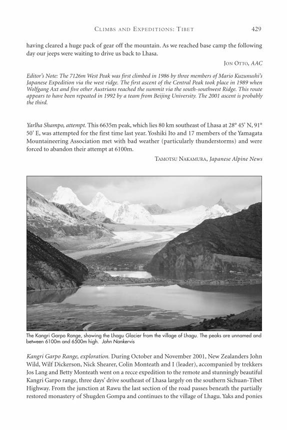
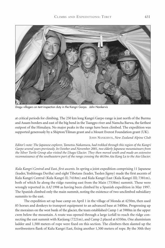
Kangri Garpo Range, exploration. During October and November 2001, New Zealanders JohnWild, Wilf Dickerson, Nick Shearer, Colin Monteath and I (leader), accompanied by trekkersJos Lang and Betty Monteath went on a recce expedition to the remote and stunningly beautifulKangri Garpo range, three days’ drive southeast of Lhasa largely on the southern Sichuan-TibetHighway. From the junction at Rawu the last section of the road passes beneath the partiallyrestored monastery of Shugden Gompa and continues to the village of Lhagu. Yaks and ponies
The Kangri Garpo Range, showing the Lhagu Glacier from the village of Lhagu. The peaks are unnamed andbetween 6100m and 6500m high. John Nankervis
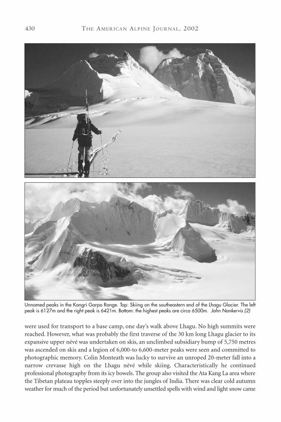
TH E AM E R I C A N AL P I N E JO U R NA L, 2002430
were used for transport to a base camp, one day’s walk above Lhagu. No high summits werereached. However, what was probably the first traverse of the 30 km long Lhagu glacier to itsexpansive upper névé was undertaken on skis, an unclimbed subsidiary bump of 5,750 metreswas ascended on skis and a legion of 6,000-to 6,600-meter peaks were seen and committed tophotographic memory. Colin Monteath was lucky to survive an unroped 20-meter fall into anarrow crevasse high on the Lhagu névé while skiing. Characteristically he continued professional photography from its icy bowels. The group also visited the Ata Kang La area wherethe Tibetan plateau topples steeply over into the jungles of India. There was clear cold autumnweather for much of the period but unfortunately unsettled spells with wind and light snow came
Unnamed peaks in the Kangri Garpo Range. Top: Skiing on the southeastern end of the Lhagu Glacier. The leftpeak is 6127m and the right peak is 6421m. Bottom: the highest peaks are circa 6500m. John Nankervis (2)
CL I M B S A N D EX P E D I T I O N S : TI B E T 431
at critical periods for climbing. The 250 km long Kangri Garpo range is just north of the Burmaand Assam borders and east of the big bend in the Tsangpo river and Namcha Barwa, the farthestoutpost of the Himalaya. No major peaks in the range have been climbed. The expedition wassupported generously by a Shipton/Tilman grant and a Mount Everest Foundation grant (UK).
JOHN NANKERVIS, New Zealand Alpine Club
Editor’s note: The Japanese explorer, Tamotsu Nakamura, had trekked through this region of the KangriGarpo several years previously. In October and November 2001, two elderly Japanese mountaineers fromthe Silver Turtle Group also visited the Lhagu Glacier. They then moved south and made an extensivereconnaissance of the southeastern part of the range crossing the 4610m Ata Kang La to the Ata Glacier.
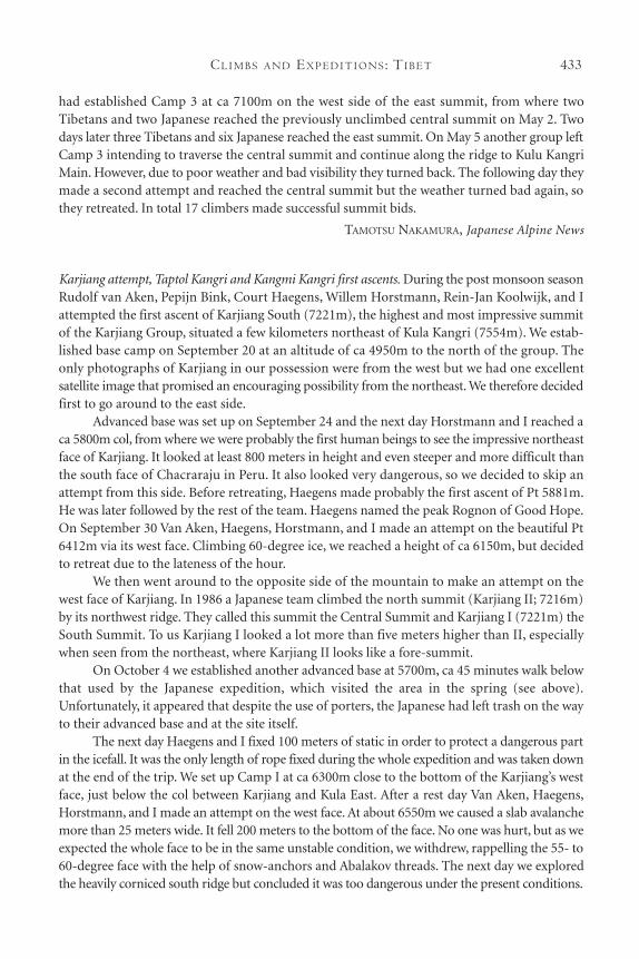
Kula Kangri Central and East, first ascents. In spring a joint expedition comprising 11 Japanese(leader, Yoshitsugu Deriha) and eight Tibetans (leader, Tseden Jigmy) made the first ascents ofKula Kangri Central (Kula Kangri II; 7418m) and Kula Kangri East (Kula Kangri III; 7381m),both of which lie along the ridge running east from the Main (7538m) summit. These werewrongly reported in AAJ 1998 as having been climbed by a Spanish expedition in May 1997.The Spanish climbed only the main summit, noting the existence of two unclimbed subsidiarysummits to the east.
The expedition set up base camp on April 1 in the village of Monda at 4250m, then used85 horses and donkeys to transport equipment to an advanced base at 5400m. Progressing upthe moraines on the west bank of the glacier, the team established Camp 1 at 5900m in the uppercwm below the mountain. A route was opened through a large icefall to reach the ridge con-necting the east summit with Karjiang (7221m), and Camp 2 placed at 6350m. One aluminiumladder and 1,500 meters of rope were fixed on this section. The climbers then slanted up thenorthwestern flank of Kulu Kangri East, fixing another 1,500 meters of rope. By the 30th they
Lhagu villagers on tent-inspection duty in the Kangri Garpo. John Nankervis
TH E AM E R I C A N AL P I N E JO U R NA L, 2002432
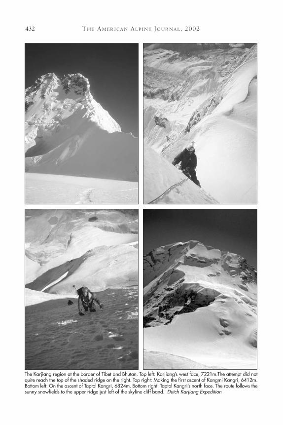
The Karjiang region at the border of Tibet and Bhutan. Top left: Karjiang’s west face, 7221m.The attempt did notquite reach the top of the shaded ridge on the right. Top right: Making the first ascent of Kangmi Kangri, 6412m.Bottom left: On the ascent of Taptol Kangri, 6824m. Bottom right: Taptol Kangri’s north face. The route follows thesunny snowfields to the upper ridge just left of the skyline cliff band. Dutch Karjiang Expedition
CL I M B S A N D EX P E D I T I O N S : TI B E T 433
had established Camp 3 at ca 7100m on the west side of the east summit, from where twoTibetans and two Japanese reached the previously unclimbed central summit on May 2. Twodays later three Tibetans and six Japanese reached the east summit. On May 5 another group leftCamp 3 intending to traverse the central summit and continue along the ridge to Kulu KangriMain. However, due to poor weather and bad visibility they turned back. The following day theymade a second attempt and reached the central summit but the weather turned bad again, sothey retreated. In total 17 climbers made successful summit bids.
TAMOTSU NAKAMURA, Japanese Alpine News
Karjiang attempt, Taptol Kangri and Kangmi Kangri first ascents. During the post monsoon seasonRudolf van Aken, Pepijn Bink, Court Haegens, Willem Horstmann, Rein-Jan Koolwijk, and Iattempted the first ascent of Karjiang South (7221m), the highest and most impressive summitof the Karjiang Group, situated a few kilometers northeast of Kula Kangri (7554m). We estab-lished base camp on September 20 at an altitude of ca 4950m to the north of the group. Theonly photographs of Karjiang in our possession were from the west but we had one excellentsatellite image that promised an encouraging possibility from the northeast. We therefore decidedfirst to go around to the east side.
Advanced base was set up on September 24 and the next day Horstmann and I reached aca 5800m col, from where we were probably the first human beings to see the impressive northeastface of Karjiang. It looked at least 800 meters in height and even steeper and more difficult thanthe south face of Chacraraju in Peru. It also looked very dangerous, so we decided to skip anattempt from this side. Before retreating, Haegens made probably the first ascent of Pt 5881m.He was later followed by the rest of the team. Haegens named the peak Rognon of Good Hope.On September 30 Van Aken, Haegens, Horstmann, and I made an attempt on the beautiful Pt6412m via its west face. Climbing 60-degree ice, we reached a height of ca 6150m, but decidedto retreat due to the lateness of the hour.
We then went around to the opposite side of the mountain to make an attempt on thewest face of Karjiang. In 1986 a Japanese team climbed the north summit (Karjiang II; 7216m)by its northwest ridge. They called this summit the Central Summit and Karjiang I (7221m) theSouth Summit. To us Karjiang I looked a lot more than five meters higher than II, especiallywhen seen from the northeast, where Karjiang II looks like a fore-summit.
On October 4 we established another advanced base at 5700m, ca 45 minutes walk belowthat used by the Japanese expedition, which visited the area in the spring (see above).Unfortunately, it appeared that despite the use of porters, the Japanese had left trash on the wayto their advanced base and at the site itself.
The next day Haegens and I fixed 100 meters of static in order to protect a dangerous partin the icefall. It was the only length of rope fixed during the whole expedition and was taken downat the end of the trip. We set up Camp I at ca 6300m close to the bottom of the Karjiang’s westface, just below the col between Karjiang and Kula East. After a rest day Van Aken, Haegens,Horstmann, and I made an attempt on the west face. At about 6550m we caused a slab avalanchemore than 25 meters wide. It fell 200 meters to the bottom of the face. No one was hurt, but as weexpected the whole face to be in the same unstable condition, we withdrew, rappelling the 55- to60-degree face with the help of snow-anchors and Abalakov threads. The next day we exploredthe heavily corniced south ridge but concluded it was too dangerous under the present conditions.
TH E AM E R I C A N AL P I N E JO U R NA L, 2002434
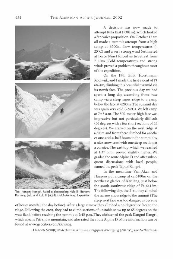
A decision was now made toattempt Kula East (7381m), which lookeda far easier proposition. On October 13 weall made a summit attempt from a highcamp at 6700m. Low temperatures (-25°C) and a very strong wind (estimatedat Force Nine) forced us to retreat from7110m. Cold temperatures and strongwinds proved a problem throughout mostof the expedition.
On the 19th Bink, Horstmann,Koolwijk, and I made the first ascent of Pt6824m, climbing this beautiful pyramid viaits north face. The previous day we hadspent a long day ascending from basecamp via a steep snow ridge to a campbelow the face at 6200m. The summit daywas again very cold (-24°C). We left campat 7:45 a.m. The 500-meter-high face wasimpressive but not particularly difficult(50 degrees with a few short sections of 55degrees). We arrived on the west ridge at6700m and from there climbed for anoth-er one-and-a-half hours to the summit bya nice snow crest with one steep section ata cornice. The east top, which we reachedat 1:37 p.m., proved slightly higher. Wegraded the route Alpine D and after subse-quent discussions with local people,named the peak Taptol Kangri.
In the meantime Van Aken andHaegens put a camp at ca 6100m on thenortheast glacier of Karjiang, just belowthe south-southwest ridge of Pt 6412m.The following day, the 21st, they climbedthe narrow snow ridge to the summit (Thesteep west face was too dangerous because
of heavy snowfall the day before). After a large rimaye they climbed a 55-degree ice face to theridge. Following the crest, they had to climb sections of unstable snow up to 65 degrees on thewest flank before reaching the summit at 2:45 p.m. They christened the peak Kangmi Kangri,which means Yeti snow mountain, and also rated the route Alpine D. More information can befound at www.geocities.com/karjiang.
HAROEN SCHIJF, Nederlandse Klim-en BergsportVereniging (NKBV), the Netherlands
Top: Kangmi Kangri. Middle: descending Kula III. Bottom:Karjiang (left) and Kula III (right). Dutch Karjiang Expedition
CL I M B S A N D EX P E D I T I O N S : TI B E T 435
Tibet, tips on organizing a climbing trip. All peaks over 5,500 meters in Tibet officially require aclimbing permit, which be issued by the Chinese Tibetan Mountaineering Association. CTMA isthe government organization authorized to oversee mountaineering activities in Tibet. In addi-tion to your climbing permit, CTMA also supplies you with logistical support up to base camp.This includes transportation, liaison officer, lodging and yaks, among others. You pay a fee for allthese services in addition to the permit. You cannot simply buy the climbing permit and go to themountain on your own.
When arranging your climb, your team can apply directly to the CTMA or through anagency that specializes in running climbs to the Himalaya. Dealing directly with the CTMA canbe laborious, time consuming, confusing, and often more expensive than going through anagency. These agencies have price contracts with the CTMA, have worked with them for years,and are familiar with the CTMA’s exact services, quality of services, and working procedures.Furthermore, an agency can organize every other crucial part of a climb from base camp food,cooks, and equipment to high-altitude climbing assistants (Sherpas), tents, and more—manyessential services the CTMA does not even offer.
There are companies that work directly with the CTMA in organizing climbs to theTibetan Himalaya. A handful are Nepalese agencies based out of Kathmandu. Two NorthAmerican companies, Himalaya Incorporated (Seattle, WA) and my own BlueSheep Adventures(Bellingham, WA), cater to climbers from around the world. BlueSheep specializes in organizingexpeditions to mountains in Tibet and China only. Both companies concentrate on high-quality,inexpensive climbs. They cater to pre-organized teams that only require logistical support toindividuals that are looking for a fully supported expedition. They also actively support the useof Tibetans on the mountain as high-altitude climbing assistants, cooks, and porters—worktraditionally done by Nepalese Sherpas—as a way to assist poor families in Tibet.
If you work directly with an agency in Asia, consider the Nepalese companies AsianTrekking or Global Expeditions. In Lhasa, a good company that offers trekking, though notclimbing services, is Windhorse Adventures; the manager, Jampa, speaks excellent English.Contacts: [email protected] or [email protected]; (tel.) + 86-891-6833009; (fax) +86-891-6836793. Himalaya Incorporated can be reached at: (206) 329-4107; [email protected]; www.Himalayaclimb.com. My company: Bluesheeptravel.com; 703-593-4799;[email protected].
You can contact the CTMA directly at East Lingo Rd. #10 Lhasa, Tibet 850000, China; (tel.)+ 86-891-6333720; (fax) + 86-891-6336366; (e-mail) [email protected].
Culturally-oriented maps to most of Tibet can be found at www.tibetmap.com. TheDepartment of Defense 1:500,000-scale TPC H-10A and H-10B maps cover most of Tibet with1,000-foot contour intervals. Order from: MapLink, (805) 692-6777, www.maplink.com; or OmniResources, (800) 742-2677, www.omnimap.com.
No matter whom you go through, make sure to verify exactly what is included in theprice. Inquire in detail about quality and type of base camp and high-altitude equipment andfood; extra potential fees and over-use yak fees; climbing ability, quality, and nationality of theclimbing staff (Sherpas), and cooks. You will probably have many other concerns as well. Makesure you get all your questions answered in a satisfactory and clear way.
JON OTTO, AAC, BlueSheep Adventure
Southeast Asia
KOREA
Towuangseong Falls, Korean ice climbingoverview. For climbers in the Seoul area,the usual place to practice rock-climbingis Insu Peak on Bukhan Mountain. Noone is exactly sure when the sport of ice-climbing was introduced to Korea, butlong-time members of the Corean AlpineClub first ice-climbed in CheonbuldongValley located at Mt. Sorak some timeduring the early sixties. And to help theprogram develop, the Corean AlpineClub sent some of its youngest membersto study at the Ecole Nationale de Ski etd`Alpinisme in Chamonix, France in theearly seventies. After learning the moreadvanced mountaineering skills andtechniques used by Europeans, this newand younger generation of climbershelped the Korean ice-climbing scene geton the right track.
The first Korean protégés of the French alpine school have become the benchmark towhich all Korean climbers aspire. They pioneered the way for all Korean climbing enthusiastsby venturing out on Korea’s first-ever expeditions to the hard “blue” ice of the Himalayan,Eastern European, and North American ranges. Their experiences, knowledge, and techniqueslearned and practiced on these and other ranges are what have made it possible for Korea’sgreatest alpinists to accomplish what they have accomplished today.
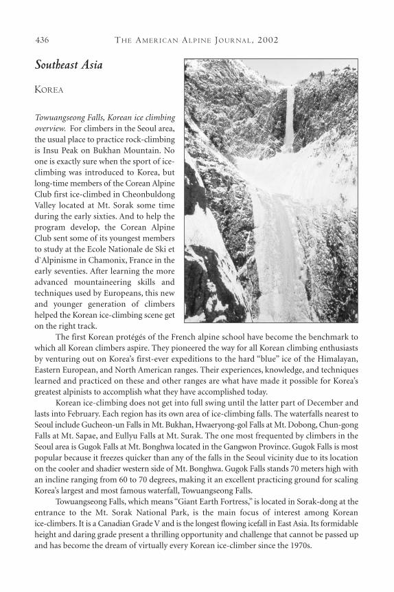
Korean ice-climbing does not get into full swing until the latter part of December andlasts into February. Each region has its own area of ice-climbing falls. The waterfalls nearest toSeoul include Gucheon-un Falls in Mt. Bukhan, Hwaeryong-gol Falls at Mt. Dobong, Chun-gongFalls at Mt. Sapae, and Eullyu Falls at Mt. Surak. The one most frequented by climbers in theSeoul area is Gugok Falls at Mt. Bonghwa located in the Gangwon Province. Gugok Falls is mostpopular because it freezes quicker than any of the falls in the Seoul vicinity due to its locationon the cooler and shadier western side of Mt. Bonghwa. Gugok Falls stands 70 meters high withan incline ranging from 60 to 70 degrees, making it an excellent practicing ground for scalingKorea’s largest and most famous waterfall, Towuangseong Falls.
Towuangseong Falls, which means “Giant Earth Fortress,” is located in Sorak-dong at theentrance to the Mt. Sorak National Park, is the main focus of interest among Korean ice-climbers. It is a Canadian Grade V and is the longest flowing icefall in East Asia. Its formidableheight and daring grade present a thrilling opportunity and challenge that cannot be passed upand has become the dream of virtually every Korean ice-climber since the 1970s.
TH E AM E R I C A N AL P I N E JO U R NA L, 2002436
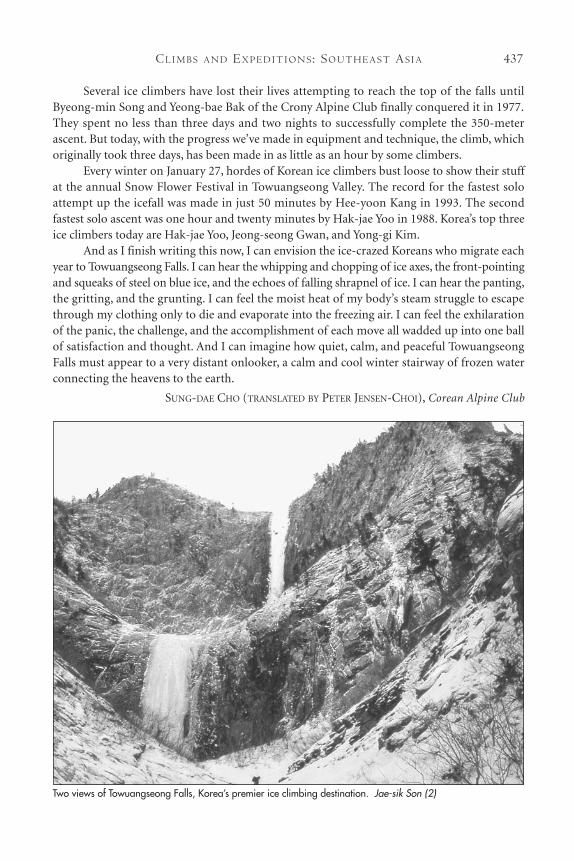
Several ice climbers have lost their lives attempting to reach the top of the falls untilByeong-min Song and Yeong-bae Bak of the Crony Alpine Club finally conquered it in 1977.They spent no less than three days and two nights to successfully complete the 350-meterascent. But today, with the progress we’ve made in equipment and technique, the climb, whichoriginally took three days, has been made in as little as an hour by some climbers.
Every winter on January 27, hordes of Korean ice climbers bust loose to show their stuffat the annual Snow Flower Festival in Towuangseong Valley. The record for the fastest soloattempt up the icefall was made in just 50 minutes by Hee-yoon Kang in 1993. The secondfastest solo ascent was one hour and twenty minutes by Hak-jae Yoo in 1988. Korea’s top threeice climbers today are Hak-jae Yoo, Jeong-seong Gwan, and Yong-gi Kim.
And as I finish writing this now, I can envision the ice-crazed Koreans who migrate eachyear to Towuangseong Falls. I can hear the whipping and chopping of ice axes, the front-pointingand squeaks of steel on blue ice, and the echoes of falling shrapnel of ice. I can hear the panting,the gritting, and the grunting. I can feel the moist heat of my body’s steam struggle to escapethrough my clothing only to die and evaporate into the freezing air. I can feel the exhilarationof the panic, the challenge, and the accomplishment of each move all wadded up into one ballof satisfaction and thought. And I can imagine how quiet, calm, and peaceful TowuangseongFalls must appear to a very distant onlooker, a calm and cool winter stairway of frozen waterconnecting the heavens to the earth.
SUNG-DAE CHO (TRANSLATED BY PETER JENSEN-CHOI), Corean Alpine Club
CL I M B S A N D EX P E D I T I O N S : SO U T H E A S T AS I A 437
Two views of Towuangseong Falls, Korea’s premier ice climbing destination. Jae-sik Son (2)

TH E AM E R I C A N AL P I N E JO U R NA L, 2002438
LAOS
Paa Daeng Tower,Vang Vieng, new limestone climbs. In November 1999 Kirsten Kremer and Ibecame only the second party to climb in the southeast Asian republic of Laos, when we putup a new route on the overhanging limestone wall of Paa Daeng or The Red Cliff. Paa Daengis situated in full view of the rapidly expanding village of Vang Vieng, itself ca 150 kilometersnorth of the capital, Vientiane. We first spent two days cutting a way up third and fourth classvertical jungle terrain, keeping a careful eye on the local cobras and pit vipers, and avoiding afire ant colony near the top. We reached the base of the main wall and found to our amaze-ment it was a very steep cave, abounding with amazing pocket and tufa features. We had bothspent many months climbing the bolted routes in Thailand and always wondered if there wassimilar terrain in Laos, which could be protected by traditional gear. The rock proved to be thebest quality Southeast Asian karst and we committed to a full trad-style route straight out ofthe cave and up onto the headwall. On the first pitch we found perfect threads through pock-ets all the way and finally belayed at the top of a large stalactite below the lip of the cave,already 10 meters out from the base of the wall. The following day we began the second pitch,which climbed over the lip of the cave right of the stalactite and onto a slightly overhangingwall of crisp pockets. This pitch was well protected by Tricams, nuts, Camalots, and threads,and ended another eight meters out from the belay, where we placed two bolts. We fixed a ropedown to the first belay and descended to town. Judging by the number of cobra skins we saw,bivouacs are not to be recommended.
The third pitch involved vertical razor edges with occasional cracks, fire ants, and somescary snake grass patches. Protection was spaced but adequate. The pitch ended on a finewind-polished ledge with a large thread. One more pitch led up an amazing overhanging wallof unbelievable-quality red karst with threads readily available. Unfortunately it ended, left ofthe pointed top of the face, in the most heinous razor-rock vertical jungle imaginable. Wedescended to clean rock and rappelled the route. Two O’clock Wall is IV+ F6c.
Throughout the last day I had noticed a saffron dot in the sea of green rice below: amonk. The previous climbing party to visit Laos comprised Americans and Japanese, whoestablished a number of sport routes close to the Mekong. The local headman in that areaappears to be unhappy about their behavior. Local people have strong beliefs in mountain,cliff, and especially cave spirits, and do not take kindly to people hammering the rock or dam-aging it by placing bolts. We were careful to pick a venue that avoided offending cave spiritsand when we came down that night, the villagers were friendly. We had obviously passed thescrutiny of the monk and had been accepted. The rice harvest was coming and the villagersthought we’d cause bad weather for their harvest by being above the fields and angering themountain spirits. Moral: always check with your local monk. After that we never had a problemand completed 12 other routes, which were shorter but harder. On our return the followingyear we were treated like gold. Laos is a place to tread lightly, not only because of the millionsof land mines and unexploded bombs. Respect will get you everything. This is a Buddhist/communist country and the people are proud to have survived all their troubles, while tryingto find their way in the modern world.
PAUL TURECKI
CL I M B S A N D EX P E D I T I O N S : SO U T H E A S T AS I A 439
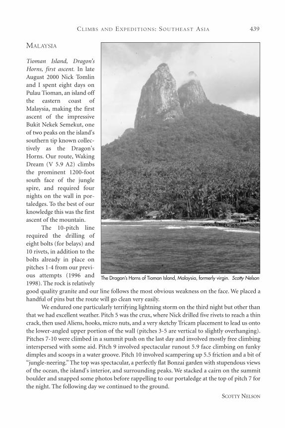
MALAYSIA
Tioman Island, Dragon’sHorns, first ascent. In lateAugust 2000 Nick Tomlinand I spent eight days onPulau Tioman, an island offthe eastern coast ofMalaysia, making the firstascent of the impressiveBukit Nekek Semekut, oneof two peaks on the island'ssouthern tip known collec-tively as the Dragon'sHorns. Our route, WakingDream (V 5.9 A2) climbsthe prominent 1200-footsouth face of the junglespire, and required fournights on the wall in por-taledges. To the best of ourknowledge this was the firstascent of the mountain.
The 10-pitch linerequired the drilling ofeight bolts (for belays) and10 rivets, in addition to thebolts already in place onpitches 1-4 from our previ-ous attempts (1996 and1998). The rock is relativelygood quality granite and our line follows the most obvious weakness on the face. We placed ahandful of pins but the route will go clean very easily.
We endured one particularly terrifying lightning storm on the third night but other thanthat we had excellent weather. Pitch 5 was the crux, where Nick drilled five rivets to reach a thincrack, then used Aliens, hooks, micro nuts, and a very sketchy Tricam placement to lead us ontothe lower-angled upper portion of the wall (pitches 3-5 are vertical to slightly overhanging).Pitches 7-10 were climbed in a summit push on the last day and involved mostly free climbinginterspersed with some aid. Pitch 9 involved spectacular runout 5.9 face climbing on funkydimples and scoops in a water groove. Pitch 10 involved scampering up 5.5 friction and a bit of“jungle-neering.” The top was spectacular, a perfectly flat Bonzai garden with stupendous viewsof the ocean, the island's interior, and surrounding peaks. We stacked a cairn on the summitboulder and snapped some photos before rappelling to our portaledge at the top of pitch 7 forthe night. The following day we continued to the ground.
SCOTTY NELSON
The Dragon’s Horns of Tioman Island, Malaysia, formerly virgin. Scotty Nelson


![INDEX [c498469.r69.cf2.rackcdn.com]c498469.r69.cf2.rackcdn.com/1990/370_index_aaj1990.pdf · 2011-04-06 · Gorilla Monsoon, John Long, 323-25 High Altitude Medicine and Pathology,](https://img.pdfslide.us/doc/110x75/5f8aa2219f021b7f284e73da/index-c498469r69cf2-c498469r69cf2-2011-04-06-gorilla-monsoon-john-long.jpg)


![INDEX [c498469.r69.cf2.rackcdn.com]c498469.r69.cf2.rackcdn.com/1986/341_index_aaj1986.pdf · BoJor, Ovidiu, 251 Boks (Tien Shari,, USSR), 304 Bolivar (Merida, Sierra Nevada de, Venezuela),](https://img.pdfslide.us/doc/110x75/5a84c2e17f8b9a882e8bc09f/index-c498469r69cf2-c498469r69cf2-ovidiu-251-boks-tien-shari-ussr.jpg)
![INDEX [c498469.r69.cf2.rackcdn.com]c498469.r69.cf2.rackcdn.com/1987/371_index_aaj1987.pdf · INDEX Volume 29 l Issue 61 l 1987 Compiled by Patricia A. Fletcher This issue comprises](https://img.pdfslide.us/doc/110x75/5ba031f109d3f2fb538c1ebf/index-c498469r69cf2-c498469r69cf2-index-volume-29-l-issue-61-l-1987.jpg)


![Masanori Onishi arXiv:1505.03552v1 [astro-ph.EP] 13 May 2015](https://img.pdfslide.us/doc/110x75/625cf09079c19a2829266cdb/masanori-onishi-arxiv150503552v1-astro-phep-13-may-2015.jpg)
