Embed Size (px)
Citation preview

4.0 - Environmental Analysis 4.1 - Land Use
This section of the EIR addresses the existing conditions for each impact area, the impact threshold for
determining significance of environmental impacts, identification of environmental impacts and the
significance of the impact, mitigation measures for those environmental impacts which are deemed
significant, and the conclusion after implementation of mitigation measures.
This EIR examines all of the environmental issue areas identified by the Agency and through comments
received on the Notice of Preparation (NOP) and at the public scoping meeting. Each impact is discussed
and analyzed in the sections that follow. Each environmental impact issue area is addressed according to
the following format:
Existing Conditions: A discussion of the existing conditions, services, and physical environment of the
Project Area.
Impact Threshold: The amount or type of impact which contributes a substantial or potentially substantial
adverse change in the environment, based on the thresholds contained in the Environmental Checklist
contained in Appendix G of the California Environmental Quality Act (CEQA) Guidelines and/or applicable
City of San Diego thresholds and standards. Based on this criterion, project impacts can be classified as:
significant and unavoidable; significant, but can be mitigated, avoided, or substantially lessened; or less
than significant.
Impact: A discussion of the impacts of the proposed project in quantitative and/or qualitative terms,
based on the uses of land identified in the project description.
Significance of Impact A brief statement as to the significance of the impact.
Mitigation Measures: A discussion of the measures required to avoid, mitigate, or substantially lessen
significant impacts.
Conclusion: A discussion of the level of impact of the project following the implementation of required or
recommended mitigation measures.
4.0.1 Areas Of Potential Environmental Impact 1. Land Use 8. Hazards and Hazardous Materials
2. Transportation/Circulation 9. Paleontological Resources
3. Air Quality 10. Aesthetics
4. Noise 1 1. Water QualityIHydrology
5. Cultural Resources 12. Population/Housing
6. Biological Resources 13. Public Services
7. Geology/Soils 14. Mineral Resources
Grantville Redevelopment Project Final Program EIR
4.1-1 March 2005

4.0 - Environmental Analysis 4.1 - Land Use
Detailed discussions of these environmental issue areas are found in the following sections. Additionally,
cumulative impacts are discussed in Section 5.0, growth-inducing impacts and significant irreversible
environmental changes are discussed in Section 6.0, and areas of no significant impact are discussed in
Section 7.0 of this EIR.
Grantville Redevelopment Project Final Program EIR
March 2005

4.0 - Environmental Analysis 4.1 - Land Use CI*LI*-
Land Use
Existing Conditions
4.7.7.7 Existing Land Uses
A. Project Site
The Project Area is located in a generally urbanized area of the City, with a majority of the land parcels
fronting Mission Gorge Road, Friars Road, Waring Road and Fairmount Avenue. There are a variety of
existing development types within the Project Area, including commercial and office, commercial
recreation (portions of the Admiral Baker golf course), light industrial uses, sand and gravel extractive
industry, public facilities (e.g. a post office), schools, transportation, commercial agriculture (nursery), parks,
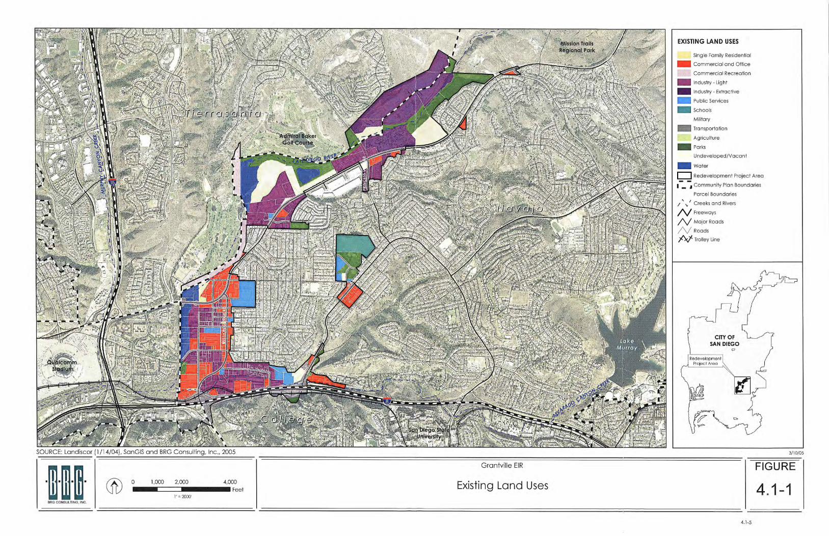
open space, and vacant land uses. Figure 4.1-1 depicts the existing land uses within the Project Area, as
derived from SANGIS and a land use survey conducted by BRG Consulting on September 1 and 6, 2004.
Based on the SANGIS data and land use survey, the existing land use is currently comprised of
approximately 16.5 percent commercial and office (including commercial recreation), 25.4 percent
industrial (light and extractive), 7.6 percent public services, 6.4 percent schools, 0.1 2 percent military, 13.5
percent transportation, 14.3 percent parks, 0.10 percent agriculture, 4.5 percent water, and 11.4 percent
undeveloped and vacant land uses. Table 4.1-1 provides a statistical summary of the existing land uses
within the Project Area based on the land use survey.
The approximately 165 acres of existing commercial, office and commercial recreation land uses in the
Project Area are primarily located along Mission Gorge and Friars Road.
The existing industrial uses, which include light and extractive, total approximately 459 acres. Industrial uses
are located throughout the entire Project Area, with the largest acreages occurring in the northern portion
of the Project Area, along Mission Gorge Road.
Existing public services (including transportation) and school land uses total approximately 152 acres of
land. The school uses total approximately 25 acres. The 186 acres of public and institutional (e.g., church,
hospital) land uses are located adjacent to land uses located along Mission Gorge Road, Waring Road,
and north of the Interstate 8 (1-8) freeway.
Parks, open space, and water land uses, total approximately 77 acres in the Project Area. A majority of this
acreage consists of the open space associated with the Sun Diego River, located along the northern and
western boundaries of the Project Area. The Allied Gardens Community Park is also located within Subarea
C of the Project Area.
Vacant land (not including existing sand and gravel areas) in the Project Area totals approximately 69
acres, The majority of the vacant land within the Project Area is located in the northern area along Mission
Gorge Road. A smalt portion of vacant/undeveloped land is located in the southern portion of the Project
Area along Waring Road.
Grantville Redevelopment Projeci Final Program EIR
4.1-3 March 2005

4.0 - Environmental Analysis 4.1 - Land Use
TABLE 4.1 -1 Existing Land Uses
Notes: = The 68.92 acres of arkl land in the Proiect Area consists of 23.7 acres of ~o~u lo t ion- based arks (Lewis middle school and ballfields), and 45.22 acres of resource-based and open mace park area.
Source: BRG Consulting, Inc., 2004.
B. Surrounding land Uses Because the Project Area is relatively large, it is surrounded by a variety of land uses, all of which are similar
to the types of urban land uses that are located within the Project Area. In a more regional perspective,
the Community of Tierrasanta, Admiral Baker Golf Course, Mission Trails Regional Park, and residential land
uses are located to the north and northeast; the City of La Mesa and residential uses are located to the
east; Sun Diego State University, 1-8, and residential uses are located southeast and south, and residential
uses, the Sun Diego River, 1-1 5 and the Qualcomm Stadium are located west of the Project Area.
4.7.7.2 Sun Diego Progress Guide and General Plan The Project Area is located entirely within the Sun Diego City limits. Land use and development within the
City is governed by the City of San Diego Progress Guide and General Plan, adopted by the City in 1979.
The Progress Guide and General Plan provide the City's development policies in the form of findings, goals,
guidelines, standards, and recommendations. Guidelines for Future Development, Amendment to the
Progress Guide and General Plan (October 1, 1992), includes a Development Program that establishes
specific guidelines to phase the level of new growth and development to the carrying capacity of
programmed public facilities over time. The following lists the Goals, Guidelines and Standards for
Redevelopment and reinvestment within the City of Sun Diego as identified in the Progress and Guide and
General Plan.
Grantville Redevelopment Project 4.1-4 March 2005 Final Program EIR

4.0 - Environmental Analysis 4.1 - Land Use
Gods
Stimulate private investment in order to remove and prevent physical, economic, and social blight.
Assure quality development in redevelopment areas.
Rehabilitate and creatively reuse older structures whenever possible.
Provide mechanisms so that housing is not allowed to deteriorate into substandard conditions.
Preserve and increase affordable housing and minimize additional effects of displacement due to
redevelopment.
Encourage in-fill development in redevelopment areas where revitalization is desired as a means to
provide housing, employment, and transit opportunities.
Guidelines and Standards
The City should subsidize impact fees, voluntary advance payments and other revenue sources for
development proposals in designated redevelopment areas.
Rehabilitation and adaptive reuse of buildings should be encouraged where appropriate. Buildings
should be protected for historical significance as well as social significance.
Redevelopment projects should be evaluated through the community planning process to
determine the impact on the social and economic fabric of the community.
Provide incentives, through zoning and other mechanisms, for revitalization and re building of older
neighborhoods in ways that respect the character of the existing neighborhood.
4. 7 . 7.3 Adopted Community Plans The Project Area is located in portions of three Community Planning Areas - Navajo, Tierrasanta, and
College. Existing Community Plan land use designations of the Project Area consist of single-family
residential, multi-family residential, commercial, office, industrial, sand and gravel, schools, parks, open
space, libraries, and hospitals.
A. The Navajo Community Ptan The Navajo community, encompassing approximately 14 square miles, lies roughly north of Interstate 8,
northwest of the city of La Mesa, west of the cities of El Cajon and Santee, and southeast of the Sun Diego
River. The community includes the neighborhoods of Grantville, Allied Gardens, Del Cerro, and Sun Carlos.
The community is located among several prominent geographic features, including the San Diego River,
and the Lake Murray, Cowles Mountain, and Mission Gorge areas of Mission Trails Regional Park.
A wide variety of land uses are represented in the western portion of the Navajo community, including
detached and attached residential in Allied Gardens, and some significant commercial and light industrial
centers in Grantville, situated along both sides of Mission Gorge Road. The central and eastern portions of
Navajo are primarily residential in character in the Del Cerro and Sun Carlos neighborhoods. Pockets of
neighborhood- and community-serving commercial are situated at the intersections of major
Grantville Redevelopment Project 4.1-7 March 2005 Final Program EIR

4.0 - Environmental Analysis 4.1 - Land Use
transportation corridors, such as Navajo Road at the intersections of Jackson Drive and Lake Murray
Boulevard.
The primary goal of the Navajo community plan is to 'retain the residential character of the area' while
providing basic services which enhance the day to day lives of its residents, such as police and fire
protection and open space amenities. The plan recognizes the delicate balance between the community
and the San Diego River. Much of the community's urban runoff during storm events is conveyed to the
river and the occasional flooding of the river impacts future land use planning in the floodplain. The plan
calls for a continuous trail along the Sun Diego River. It is also designated that all structures within 150 feet
of the 100-year floodway will provide at least one pedestrian access path from the main trial to the
structure. Other goals applicable to the proposed project are described in Section 2.3 and Section 3.6 of
this ElR.
The City of San Diego Parks and Recreation Department indicates that the Navaio Community Planning
Area currently has an "active recreation" gark acreage deficit of nearly 21 acres, which is projected to
reach almost 27 acres by the year 2030.
The Navajo Community Plan was adopted by the City Council on July 29, 1982, with the Grantville
Amendment adopted on April 4, 1989.
8. The Tierrasanta Community Plan The Tierrasanta community is centrally located within the greater San Diego metropolitan area. The
industrial area of Kearney Mesa is located to the west, Miramar Naval Air Station to the north and Mission
Valley is to the southwest. Grantville lies to the south and the City of Santee to the east. The boundaries of
the planning area are Interstate 15 on the west, Friars Road and the Sun Diego River on the south, the City
of Santee on the east and Miramar Naval Air Station on the north. The planning area is approximately
6,700 acres in size, of which about 42 percent is within the proposed Mission Trails Regional Park.
The Tierrasanta community is described as a relatively low-density residential community. Commercial
areas are limited to those needed to support the community, and only one small, industriat area is
depicted on the community plan land use map. A number of open space canyons enhance the
character of the community. The community is further characterized by a large Naval housing facility in
the southwesterly sector of the community. Goals applicable to the proposed project are described in
Section 2.3 and Section 3.6 of this EIR.
The Tierrasanta Community Plan was adopted by the City Council on July 27, 1982.
C. The College Area Community Plan The College Area Community is located in the central part of the City of Sun Diego, along the southeastern
rim of Mission Valley and approximately eight miles northeast of the downtown area. The plan area
consists of approximately 1,950 acres and is developed primarily as a single-family community with
approximately 56 percent developable land devoted to that use. The College Area Community Plan
Grantville Redevelopment Project Final Program EIR
4.1-8 March 2005

4.0 - Environmental Analvsis 4.1 - Land Use
describes this area as having been impacted by Sun Diego State University located on its northern edge,
with deteriorating commercial corridor (generally along El Cajon Boulevard) on its southern edge. Traffic
congestion is also an issue confronting the community and its neighborhoods and is related to the large
University-oriented population and through-traffic traveling to and from adjacent communities. The two
main arteries, Fairmount Avenue/Montezuma Road and College Avenue, connect Interstate 8 to the
community. Goals applicable to the proposed project are described in Section 2.3 and Section 3.6 of this
EIR.
The College Area Community Plan was adopted on May 2, 1989.
4.7.7.4 M ultiple Species Conservation Program (MSCP J The Multiple Species Conservation Program (MSCP) is a comprehensive habitat conservation planning
program for southwestern Sun Diego County. The MSCP is designed to preserve a network of habitat and
open space, protecting biodiversity and enhancing the region's quality of life. The MSCP study area covers
approximately 900 square miles (582,243 acres) in southwestern Son Diego County. The study area is
bordered by Mexico to the south, National Forest Lands to the east, Pacific Ocean to the west and the San
Dieguito River valley to the north.
Within the Project Area, approximately 283 acres of habitat is located along the Sun Diego River and
adjacent to the Mission Trails Regional Park is located within the Multiple Habitat Planning Area. Section 4.6
Biological Resources of this EIR provides a detailed discussion of the project's relationship to the MSCP.
4.7.75 San Diego River Park Draft Master Plan The City of Sun Diego, under a Joint Powers Authority (JPA) is preparing a Master Plan for the Sun Diego
River Park. As identified in the draft Master Plan, the river and adjacent land uses are currently
disconnected. The river is not a focus of the communities that is flows through. The draft Master Plan
envisions the creation of a river-long park, stretching from the Sun Diego River headwaters near Julian to
the Pacific Ocean at Mission Bay.
Planning recommendations were created as part of the Draft Master Plan. Recommendations relevant to
the Redevelopment Area include coordinating with the proposed Grantville Redevelopment to preserve
additional open space along the river and at the confluence with Alvarado Creek; surfacina the Alvarado
Creek drainage, and creatina a stron~ open sRace link between Alvarado Canyon and the San Diego
River; engage Navy planners and collaborate with redevelopment of the Superior Mine to create a
continuous multi-use trail near river: and, collaborate with redevelopment of Superior Mine to create a
historic interpretation zone within development.
4.1.2 Impact Threshold The City of San Diego Significance Determination Guidelines under CEQA outlines the thresholds for
determining significance for land use. The following will be considered a significant land use impact:
Grantville Redevelopment Project Final Program EIR
March 2005

4.0 - Environmental Analysis 4.1 - Land Use
lnconsistencylconflict wifh the environmental goals, objectives, or guidelines of a community or
general plan;
Inconsistencylconflict with an adopted land use designation or intensity and indirect or secondary
environmental impacts occur (for example, development of a designated school or park site wifh a
more intensive land use could result in traffic impacts);
Substantial or extreme use incompatibility, for example, a rock crusher in a residential area; CUPS
sometimes create impacts because conflicting uses are proposed;
Development or conversion of general plan or community plan designated open space to a more
intensive land use; or
lnconsistency/conflict with adopted environmental plans for an area. For example, development of
a non-designated use within the boundaries of park master plan would fall into this category.
Impact
4.7.3.7 Development Potential Currently, the City has identified that each of the three Project Area sub-areas share common
characteristics including a large amount of underutilized land and buildings, existing incompatible land
uses, parcels of irregular form and shape which hinder development, insufficient parking, inadequate
vehicle access, and environmental constraints, The primary goals of the Redevelopment Project are: to
create a strong economic base within, and for, the Navajo Community and neighborhoods; improve the
quality of life; eliminate physical and economic blighting conditions; improve traffic flows; protect and
enhance the San Diego River; provide residents with recreational opportunities adjacent to the river;
promote a variety of land uses; and, provide publiclprivate support for the San Diego river park.
Redevelopment i s defined pursuant to Section 33020 of the CRL as "the planning, development,
replanning, redesign, clearance, reconstruction, or rehabilitiation, or any combination of these, of all or
part of a survey area, and the provision of those residential, commercial, industrial, public, or other
structures or spaces as may be appropriate or necessary in the interest of the general welfare, including
recreational and other facilities incidental or appurtenant to them." Redevelopment also includes the
activities described in Section 33021 of the CRL which comprise the following:
a. Alteration, improvement, modernization, reconstruction or rehabilitation, or any combination
of these, of existing structures in a Project Area;
b. Provision of open space and public or private recreation areas; and,
c. Replanning or redesign or development of undeveloped areas in which either of the following
conditions exist:
1 ) the areas are stagnant or improperly utilized because of defective or inadequate street
layout, faulty lot layout in relation to size, shape, accessibility or usefulness, or for other
causes; or
Grantville Redevelopment Project Final Program EIR
4,l-10 March 2005

4.0 - Environmental Analysis 4.1 - Land Use
2) the area requires replanning and land assembly for development in the interest of the
general welfare because of widely scattered ownership, tax delinquency or other reasons.
As describe in Section 3.0 of this EIR, no land use plan amendment is proposed associated with this project,
and the Redevelopment Plan will be implemented in accordance with the densities and distributions of
land use allowed under these adopted Community Plans.
The Redevelopment Project will facilitate new development and revitalization in the Project Area.
Redevelopment activities can be categorized as new residential, commercial and recreational
development that occurs on currently vacant parcels, redevelopment of existing developed, partially
developed or under utilized parcels, and public improvements (e.g., parks, street improvements, lighting,
landscaping). Figure 4.1-2 depicts the expected future land uses within the Project Area under the
Redevelopment Project, which are based on the existing Navajo, Tierrasanta, and College Community
Plan land use maps.
Table 4.1-2 provides a summary of the acreage of land use for each Community Plan category. The net
development potential of the Project Area has been estimated and is provided in Section 3.0 of this EIR.
The proposed project is required to be consistent with the adopted General Plan (or Community Plan) in
which it is located. The project does not propose an amendment to the community plan land use
designations, nor does the project propose an increase in the intensity of development potential beyond
the density and intensity allowed by the existing Community Plans and underlying zoning categories. All
future redevelopment activities will be required to be consistent with the provisions of the community plan
in which the activity is located. No impact associated with inconsistency/conflict with an adopted land
use designation or development or conversion of a General Plan or Community Plan designated open
space to a more intensive is anticipated.
TABLE 4.1 -2 Community Plan Land Use Acreage
Single-Family Residential 1 1.84 Multi-Family Residential 7.60 Commercial 80.29
Office 1 1.82 Industrial 457.1 0 Sand and Gravel 108.1 2 Schools 24.90
Parks 26.75 Open Space 96.03 Libraries 0.52
Transportation 1 12.66
TOTAL 970.61 Source: BRG Consulting, Inc., 2004.
Grantville Redevelopment Project Final Program EIR
4.1-1 1 March 2005

4.0 - Environmental Analysis 4.1 - Land Use
4.7.3.2 Compatibility of Uses within the Project Area CCRL requires that the land uses designated in the Redevelopment Project Area be consistent with the
City's General Plan. The Redevelopment Project is proposed as a catalyst to create more efficient use of
the land and reduce or eliminate incompatible uses and blight. The proposed public improvements and
private improvements to existing commercial, public services, parks, open space, transportation right-of-
ways, and vacant/undeveloped land areas i s anticipated to attract new business and improve
development. Obsolete and undersized structures will be replaced with structures that meet current design
standards and provide for more effective use of the land. On-site land use compatibility can be improved
through consolidation of parcels, and provide a comprehensive plan for the Project Area, replacing
previous development that occurred through piece-meal development in the past.
The proposed Redevelopment Project is anticipated to reduce the occurrence of incompatible land uses
that exist within the Project Area, as new projects constructed within the Project Area will need to comply
with adopted General Plan land use and Land Development Code regulations. Redevelopment of various
properties in the Project Area to current standards is expected to improve the appearance of these
properties, provide enhanced landscaping, and improve the buffering between adjacent uses as
compared to the condition of existing development throughout most of the Project Area. Land use
conflicts can be avoided or reduced through implementation of proper design and buffering techniques
as specific private development proposals come forward in the Project Area. Any new development
regulations of the City's Land Development Code and other regulations which are intended to minimize
land use conflicts would be implemented as the City reviews projects. New development within the Project
Area will bring existing non-conforming and substandard uses up to code and would reduce the amount of
existing land use conflicts. As a result blight conditions would be eliminated. Additionally, as the
Redevelopment Project is required to be consistent with the City of San Diego Progress Guide and General
Plan and the Land Development Code, no impact associated with these plans will occur. The project will
not result in substantial or extreme use incompatibility.
4.7.3.3 Compatibility of Uses with Surrounding Areas The areas surrounding the Project Area are designated with similar land uses as the Project Area.
Commercial, industrial, office, recreational, parks, open space and residential exist in the surrounding
areas. The Project Area is geographically separated by other community planning areas by the 1-8 and 1-1 5
Freeways, and the San Diego River. As the proposed Redevelopment Project is consistent with the land use
designations of the Project Area, the project is expected to be compatible uses with the surrounding areas.
Additionally, as the Redevelopment Project Area will eliminate the physical and economic blight on the
Project Area, the surrounding areas are anticipated to result in the reduction or elimination of blight
conditions as well. No impact associated with land use compatibility with the areas surrounding the Project
Area will occur.
--
Grantville Redevelopment Project Final Program EIR
4.1-12 March 2005


4.0 - Environmental Analysis 4.1 - Land Use
4.7.3.4 Consistency with the San Diego Progress Guide and General Plan The following repeats the goals, guidelines and standards for redevelopment and reinvestment within the
City of Sun Diego Progress Guide and General Plan, and describes how the project is consistent with the
goals, guidelines, and standards within the Progress Guide and General Plan:
Cools
Stimulate private investment in order to remove and prevent physical, economic, and social blight.
The proposed Redevelopment Project will stimulate private sector activity through public investment
in infrastructure. This generally includes: traffic circulation and street reconstruction, streetscape
improvements, signalization upgrades and park improvements. By implementing these and other
projects to abate the blighting conditions affecting the Project Area, the public sector will signal its
confidence in the area and provide a catalyst for private investment.
Assure quality development in redevelopment areas.
The Redevelopment Project is required to redevelop the Project Area in accordance with the
General Plan, Community Plans, and the Land Development Code of the City of San Diego, as
amended from time to time, and all other applicable state and local codes and guidelines.
Rehabilitate and creatively reuse older structures whenever possible.
The Redevelopment Project will reflect the desirable historic character of commercial areas in form
and function of new development.
Provide a mechanism so that housing is not allowed to deteriorate into substandard conditions.
The Agency is required to set aside no less than 20 percent of the tax increment revenue generated
by the Project into a special Low and Moderate Income Housing Fund. These funds are to be used
to increase, improve, and preserve the supply of low and moderate income housing in the
community.
Preserve and increase affordable housing and minimize the additional effects of displacement use
to redevelopment.
The Agency is required to set aside no less than 20 percent of the tax increment revenue generated
by the Project into a special Low and Moderate Income Housing Fund. These funds are to be used
to increase, improve, and preserve the supply of low and moderate income housing in the
community.
Encourage in-fill development in redevelopment areas and where revitalization is desired as a means
to provide housing, employment, and transit opportunities.
The Redevelopment Project will establish landmark/gateways to establish a sense of place,
incorporating urban design linkages or connections between land uses, a first time home buyers
program, promote employment, business clusters and other improvement throughout the project
Area.
Grantville Redevelopment Project Final Program EIR
4.1-15 March 2005

4.0 - Environmental Anatvsis 4.1 - Land Use
The Redevelopment Project will facilitate new development and revitalization in the Project Area.
Redevelopment activities can be categorized as new development that occurs on currently vacant
parcels, redevelopment of existing developed, partially developed or under utilized parcels, and public
improvements (e.g., parks, street improvements, lighting, landscaping). Figure 4.1 -2 depicts the expected
land uses within the Project Area under the Redevelopment Project.
The proposed project is required to be consistent with the adopted General Plan (or Community Plan). The
project will not result in an increase in the intensity of land uses than is allowed under the Community Plan
and Land Development Code. No impacts associated with inconsistency/conflict with an adopted land
use designation or development or conversion of a General Plan designated open space to a more
intensive lands use would occur.
4.7.3.5 Consistency with Adopted Community Plans The project is required to comply with the adopted Community Plans in order to guide the orderly growth
of the community. Some of the existing development within the Project Area is not currently consistent with
the land use designations identified in the Navajo, T4wwse~tc P,rec? Community Plans;
however, any new development that occurs with the implementation of the Redevelopment Project will
be consistent with the applicable Community Plan. Because future redevelopment activity will be in
compliance with all three Community Plans, no impact associated with this issue will occur.
Various public improvements, intended to mitigate the impact of the increase in population that is
expected to occur pursuant to the adopted Community Plans, as well as to mitigate existing deficiencies in
certain public facilities are identified in the Navajo, Tierrasanta and College Area Community Plans. These
improvements will be implemented as sufficient financial resources become available. The Draft
Redevelopment Plan identifies these improvements, and they will be implemented as part of the
Redevelopment Project as sufficient funding becomes available. The proposed project will be consistent
with the adopted Community Plan by providing a mechanism whereas the funding of these improvements
can take place.
4.7.3.6 M ultiple Species Conservation Program (MSCP) AWith the exception of one parcel (APN 456-01 1-1 01 all of the areas included in the MSCP are designated
as park (i.e., resource-based park) or open space land uses in the Navajo and Tierrasanta Community
Plans. The exception parcel is a portion of city-owned designated open space that is included in the
MSCP, but is designated as sinale-family residential in the Navajo Communitv Plan. The Redevelopment
Project will be consistent with these Community Plans and therefore park and open space uses will be
consistent with the MSCP. Therefore, no impact associated with MSCP will occur. Section 4.6 Biological
Resources of this EIR provides a more detailed discussion of the project's consistency with the MSCP. The
project will not result in an inconsistency/conflict with adopted environmental plans in the area.
4.1.4 Significance of Impact No significant land use impact is anticipated.
Grantville Redevelopment Project Final Program EIR
4.1-16 March 2005

4.0 - Environmental Analysis 4.1 - Land Use ___II- v .... .,..-m-
4.1.5 Mitigation Measures No mitigation measure is proposed, as no significant land use impact has been identified.
4.1.6 Conclusion Implementation of the proposed project will not result in a significant land use impact.
Grantville Redevelopment Project Final Program EIR
4.1-17 March 2005

4.0 - Environmental Analysis 4.1 - Land Use
This page intentionally left blank.
Grantville Redevelopment Project Final Program EIR
4.1-1 8 March 2005
![Water Resources - 4.1 Land Use 40/Z40 Sect 4.1...by the Freeport Regional Water Authority [FRWA], August 2003, and the Final EIR for the City of Sacramento Water Facilities Expansion](https://img.pdfslide.us/doc/110x75/60d21827a7820a72c06c4c09/water-resources-41-land-40z40-sect-41-by-the-freeport-regional-water-authority.jpg)


![I[]ARKl lAND GE()-SPATIAI, DATA CENTRl`', I-I- gdc L. No. 06 (2).pdf · 2020. 12. 22. · .I[]ARKl lAND GE()-SPATIAI, DATA CENTRl`', aiTer, IT-fl / DORANDA, RANCHi-I-I-834002 sii{q.€](https://img.pdfslide.us/doc/110x75/60eab9acb10f6716e1770d4e/iarkl-land-ge-spatiai-data-centrl-i-i-gdc-l-no-06-2pdf-2020-12.jpg)