Embed Size (px)
Citation preview
38 .
4. Site descriptions
Midpoint grid references are given for contiguous sites. Individual grid references are
given for sites containing more than one remnant.
Vegetation types within ecological units describe abundant/dominant and common
canopy species. If there is more than one canopy species, and the species are all
common within the canopy, they are listed alphabetically.
Where available, the percentage cover of ecological units has been included in the site
descriptions.
Records of threatened flora and fauna have been sourced from herbaria and other
databases and information systems mentioned in Section 2.1, or were direct
observations by Department of Conservation staff during the course of this survey.
The status of all records was checked prior to inclusion in this report. The Fauna
section of each site report is focused on significant fauna only. See Appendix 8.4 for
fauna lists in the Hokianga Ecological District.
“Not surveyed” is written in the Fauna section of the site descriptions if, at the time of
publication, the Department of Conservation, Northland Conservancy did not have
any information on significant fauna species.
4 . 1 L E V E L 1 S I T E S
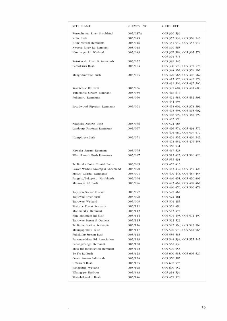
SITE NAME SURVEY NO. GRID REF.
Herekino Harbour N05/041 N05 276 580
Eaton Rd Bush O05/009A O05 404 627
Mangakotukutuku Stream Forest O05/016 O05 399 654, O05 402 661,
O05 400 666
Otaneroa Stream Remnants O05/018 O05 382 671, O05 392 670,
O05 389 666
Waiotehue Reserve O05/019 O05 392 662
Pearce Block Remnants O05/020 O05 377 662, O05 380 660,
O05 375 656
Wiseman Block O05/022 O05 382 650
Upper Uwhiroa Catchment Remnants O05/023 O05 358 650, O05 355 647,
O05 360 640, O05 347 339,
O05 363 655, O05 367 651
Central Waiotehue Rd Bush O05/024 O05 392 641, O05 386 635,
O05 389 640
Otaneroa Scenic Reserve O05/025 O05 393 628
Tongaroa Stream Remnant O05/030 O05 340 634
Dysart/Powell Rd Bush O05/032 O05 327 611, O05 317 616,
O05 313 611
Upper Herekino River O05/033 O05 298 602, N05 297 605,
N05 301 612
Pauanui Bush O05/035 O05 325 556, O05 326 547,
O05 330 541
Ngatauhe Stream Remnants O05/037 O05 312 535, O05 310 546,
O05 316 546
39.
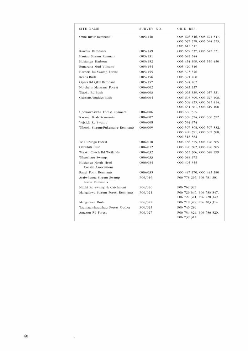
SITE NAME SURVEY NO. GRID REF.
Rotowhenua River Shrubland O05/037A O05 320 539
Kohe Bush O05/045 O05 372 532, O05 368 543
Kohe Stream Remnants O05/046 O05 351 549, O05 353 547
Awaroa River Rd Remnant O05/048 O05 369 563
Haumanga Rd Wetland O05/049 O05 367 584, O05 365 578,
O05 361 578
Rotokakahi River & Surrounds O05/052 O05 399 543
Pareokawa Bush O05/054 O05 388 578, O05 392 576,
O05 394 567, O05 378 567
Mangonuiowae Bush O05/055 O05 420 563, O05 406 562,
O05 413 575, O05 422 574,
O05 431 569, O05 437 566
Waiotehue Rd Bush O05/056 O05 395 604, O05 401 609
Tutaetohia Stream Remnant O05/059 O05 418 614
Pukemiro Remnants O05/060 O05 421 588, O05 432 595,
O05 434 595
Broadwood Riparian Remnants O05/061 O05 458 604, O05 378 599,
O05 463 598, O05 363 602,
O05 466 597, O05 482 597,
O05 473 598
Ngatieke Airstrip Bush O05/066 O05 524 585
Landcorp Paponga Remnants O05/067 O05 496 574, O05 494 576,
O05 495 580, O05 507 579
Humphreys Bush O05/071 O05 461 555, O05 469 545,
O05 473 554, O05 476 553,
O05 458 531
Kawaka Stream Remnant O05/075 O05 417 528
Wharekauere Bush Remnants O05/087 O05 515 425, O05 526 420,
O05 532 431
Te Karaka Point Coastal Forest O05/089 O05 472 415
Lower Waihou Swamp & Shrubland O05/090 O05 443 432, O05 455 426
Motuti Coastal Remnants O05/091 O05 470 445, O05 487 453
Panguru/Pukepoto Shrublands O05/094 O05 446 451, O05 450 462
Matawera Rd Bush O05/096 O05 493 462, O05 489 467,
O05 486 476, O05 500 472
Tapuwae Scenic Reserve O05/097 O05 522 467
Tapuwae River Bush O05/098 O05 522 481
Tapuwae Wetland O05/099 O05 501 485
Wairupe Forest Remnant O05/111 O05 559 490
Motukaraka Remnant O05/112 O05 573 474
Blue Mountain Rd Bush O05/114 O05 591 493, O05 572 497
Tapuwae Forest & Outliers O05/115 O05 522 522
Te Karae Station Remnants O05/116 O05 522 560, O05 525 569
Maungapohatu Bush O05/117 O05 570 570, O05 562 565
Pukekohe Stream Bush O05/118 O05 536 535
Paponga–Mata Rd Association O05/119 O05 548 534, O05 555 545
Pahangahanga Remnant O05/120 O05 565 539
Mata Rd Intersection Remnant O05/122 O05 570 555
Te Tio Rd Bush O05/123 O05 600 535, O05 606 527
Oraoa Stream Saltmarsh O05/124 O05 570 587
Umawera Bush O05/125 O05 607 575
Rangiahua Wetland O05/128 O05 690 552
Whangape Harbour O05/143 O05 334 534
Waiwhakaruku Bush O05/146 O05 479 528
40 .
SITE NAME SURVEY NO. GRID REF.
Orira River Remnants O05/148 O05 626 546, O05 621 547,
O05 637 528, O05 624 525,
O05 615 517
Rawhia Remnants O05/149 O05 659 537, O05 642 521
Hautau Stream Remnant O05/151 O05 682 544
Hokianga Harbour O05/152 O05 454 399, O05 559 450
Runaruna Mud Volcano O05/154 O05 420 546
Herbert Rd Swamp Forest O05/155 O05 373 526
Reena Bush O05/156 O05 391 408
Opara Rd QEII Remnant O05/157 O05 524 402
Northern Mataraua Forest O06/002 O06 683 337
Waoku Rd Bush O06/003 O06 663 339, O06 657 331
Classens/Duddys Bush O06/004 O06 603 399, O06 627 408,
O06 508 425, O06 625 414,
O06 634 381, O06 619 408
Upokowhawha Forest Remnant O06/006 O06 550 355
Karangi Bush Remnants O06/007 O06 558 374, O06 550 372
Vujcich Rd Swamp O06/008 O06 534 374
Wheoki Stream/Pukemaire Remnants O06/009 O06 507 393, O06 507 382,
O06 498 391, O06 507 388,
O06 518 382
Te Hurunga Forest O06/010 O06 436 375, O06 428 385
Otawhiti Bush O06/012 O06 490 382, O06 496 385
Waoku Coach Rd Wetlands O06/032 O06 655 306, O06 648 299
Whawharu Swamp O06/033 O06 688 372
Hokianga North Head O06/034 O06 405 355
Coastal Associations
Rangi Point Remnants O06/035 O06 447 370, O06 445 380
Araiwhenua Stream Swamp P06/016 P06 778 296, P06 781 301
Forest Remnants
Ninihi Rd Swamp & Catchment P06/020 P06 762 323
Mangatawa Stream Forest Remnants P06/021 P06 729 346, P06 733 347,
P06 727 341, P06 728 349
Mangatawa Bush P06/022 P06 718 329, P06 703 314
Taumatawhauwhau Forest Outlier P06/023 P06 746 294
Amazon Rd Forest P06/027 P06 734 324, P06 736 320,
P06 739 317
41.
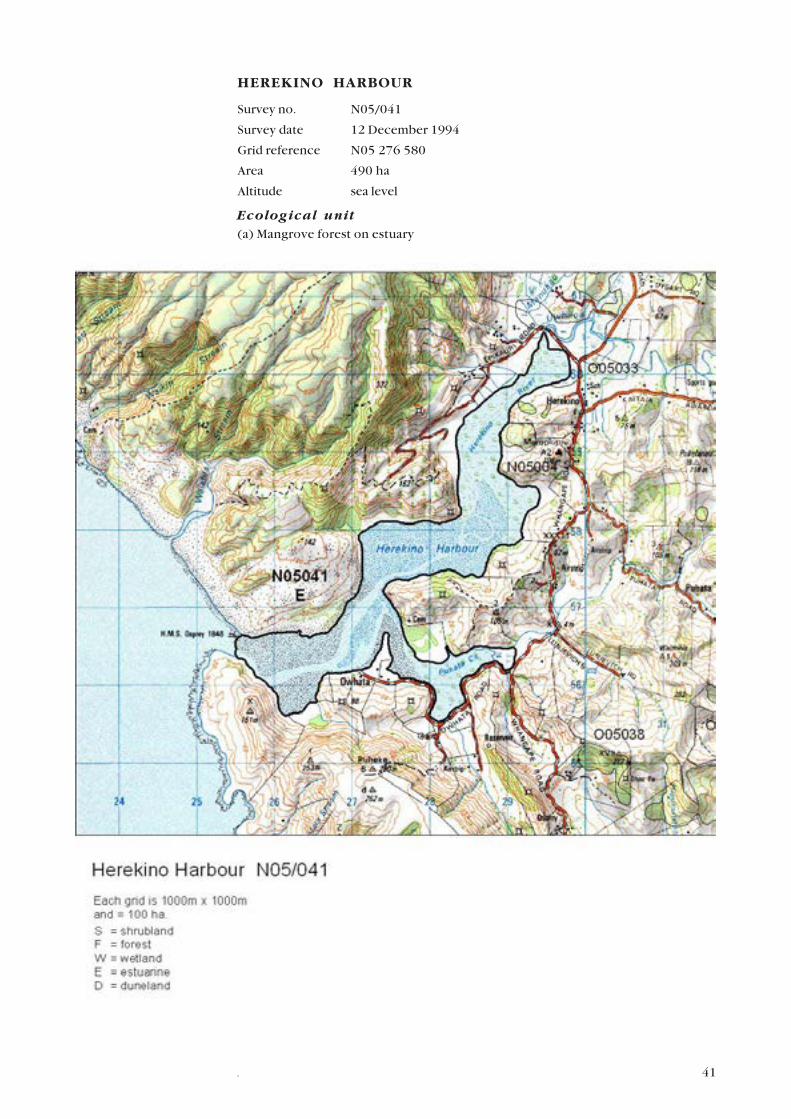
HEREKINO HARBOUR
Survey no. N05/041
Survey date 12 December 1994
Grid reference N05 276 580
Area 490 ha
Altitude sea level
Ecological unit(a) Mangrove forest on estuary
42 .
(b) Sea rush saltmarsh on estuary
(c) Oioi–sea rush saltmarsh on estuary
Landform/geologyDrowned river valley with dune areas bounding the river mouth.
Vegetation(a) Below the head of the harbour (immediately south of site O05/033 Upper
Herekino River Remnants) mangroves with sea rush and saltmarsh ribbonwood
occur.
(b) Sea rush is dominant in an extensive saltmarsh. Oioi and pohuehue are present.
(c) Oioi and sea rush with raupo, manuka and saltmarsh ribbonwood also occur.
Further down the harbour, tall mangroves, type (a) occur on either side of the
channel with sea rush in places along the landward edge.
In the Puhata Stream, there are lower mangroves, with sand flats, sea rush and
pohuehue along the southern edge.
FaunaThe harbour has been incompletely surveyed for fauna. The following bird species
have been recorded:
Australasian bittern (Nationally Endangered), Caspian tern (Nationally Vulnerable),
white–fronted tern (Gradual Decline), Northern NZ dotterel, banded rail, pied shag,
little black shag, and NI fernbird (all Sparse). Variable oystercatcher (Regionally
significant species). Other important avifauna includes bar–tailed godwit and lesser
knot.
Fish: redfinned bully and inanga recorded in 2001 from Puhata Creek tributary.
SignificanceHigh-quality estuarine habitat supporting many threatened species.
Representative site for all ecological units.
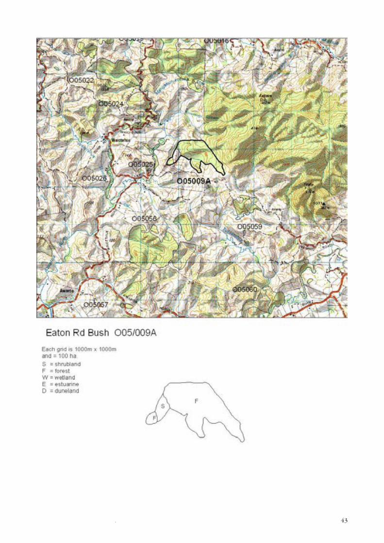
EATON RD BUSH
Survey no. O05/009A
Survey date 18 November 1994
Grid reference O05 404 627
Area 67 ha (61 ha forest, 6 ha shrubland)
Altitude 50–150 m asl
Ecological unit(a) Taraire-towai forest on hillslope
(b) Kanuka shrubland on hillslope
(c) Bracken–ring fern fernland on hillslope
(d) Towai shrubland on hillslope
Landform/geologyHillslope on Mangakahia Complex sandstone adjoining Tangihua igneous rocks.
Vegetation(a) A remnant of taraire and towai forest with frequent totara and occasional puriri,
rewarewa, rimu, kahikatea and tawa is linked to Raetea Forest by type (b) kanuka
shrubland between 4–6 m tall and type (c) bracken and ring fern fernland.
43.
44 .
(d) On the forest edge towai shrubland occurs with occasional kahikatea, mamaku,
ponga, five-finger, totara, rewarewa, and pampas.
FaunaNI brown kiwi (Serious Decline) has been reported at this site.
SignificanceAn extension of the Maungataniwha Forest tract which lies on Tangihua complex
igneous rocks but the site is lying in this Ecological District due to its geological
foundation on Mangakahia complex sandstone.
It provides a buffer to the main forest tract and is habitat for kiwi.
Only record of type (c) in the Ecological District.
The Department of Conservation administers 15 ha of this site as Conservation
Covenant.
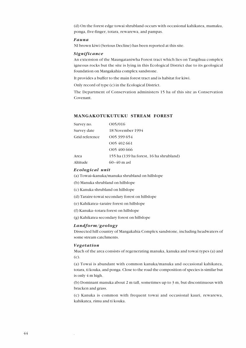
MANGAKOTUKUTUKU STREAM FOREST
Survey no. O05/016
Survey date 18 November 1994
Grid reference O05 399 654
O05 402 661
O05 400 666
Area 155 ha (139 ha forest, 16 ha shrubland)
Altitude 60–40 m asl
Ecological unit(a) Towai–kanuka/manuka shrubland on hillslope
(b) Manuka shrubland on hillslope
(c) Kanuka shrubland on hillslope
(d) Taraire-towai secondary forest on hillslope
(e) Kahikatea–taraire forest on hillslope
(f) Kanuka–totara forest on hillslope
(g) Kahikatea secondary forest on hillslope
Landform/geologyDissected hill country of Mangakahia Complex sandstone, including headwaters of
some stream catchments.
VegetationMuch of the area consists of regenerating manuka, kanuka and towai types (a) and
(c).
(a) Towai is abundant with common kanuka/manuka and occasional kahikatea,
totara, ti kouka, and ponga. Close to the road the composition of species is similar but
is only 4 m high.
(b) Dominant manuka about 2 m tall, sometimes up to 3 m, but discontinuous with
bracken and grass.
(c) Kanuka is common with frequent towai and occasional kauri, rewarewa,
kahikatea, rimu and ti kouka.
45.

46 .
(d) Taraire and towai association (away from the margins) with occasional totara,
puriri, tawa, kahikatea, kauri and rimu.
(e) Kahikatea and taraire are common near the road south of the Waiotehue Reserve.
Occasional species include pukatea, puriri, rewarewa, towai, totara and rimu.
Pukatea is a feature of this particular area. The understorey contains mahoe,
pigeonwood, five-finger, pate, rangiora, tree ferns and Astelia sp.
(f) Kanuka and totara are common in the northern part with occasional ti kouka,
rewarewa, mamaku, and towai.
(g) A small area of secondary kahikatea forest occurs with the occasional pukatea,
rimu, rewarewa, towai, taraire and puriri.
Significant flora
Pittosporum virgatum (Sparse) and Loxsoma cunninghamii (Regionally
significant species).
FaunaNI brown kiwi (Serious Decline), kukupa (Gradual Decline) and kauri snail (Gradual
Decline).
SignificanceA large area contiguous with Raetea Forest.
Presence of threatened species of national and regional significance.
Type (a) towai–kanuka/manuka shrubland is unrecorded elsewhere in the Ecological
District.
Conservation Covenant of 94 ha, administered by the Department of Conservation
protects 60.6% of this site.
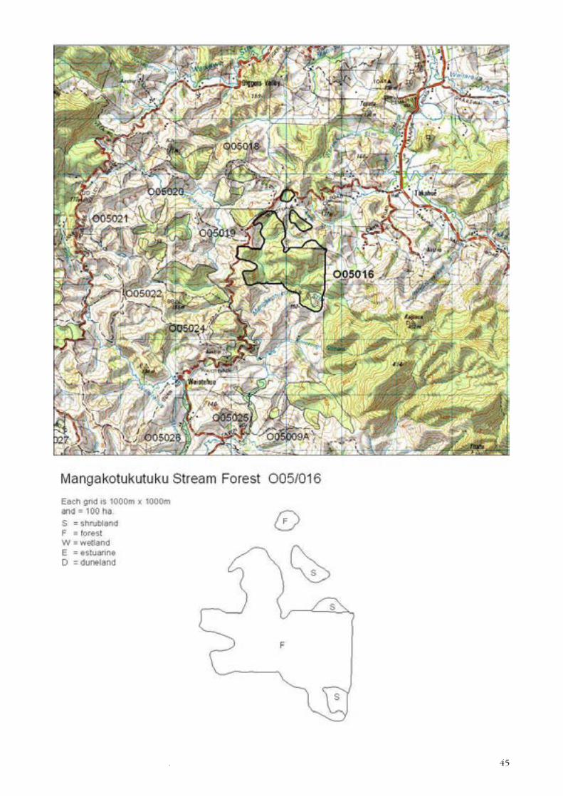
OTANEROA STREAM REMNANTS
Survey no. O05/018
Survey date 20 December 1994
Grid reference O05 382 671
O05 392 670
O05 389 666
Area 54.9 ha (41.9 ha forest; 13 ha shrubland)
Altitude 60–100 m asl
Ecological unit(a) Taraire-towai forest on hillslope
(b) Kanuka forest on hillslope
(c) Taraire forest on hillslope
(d) Kahikatea secondary forest in gully and hillslope
(e) Kanuka shrubland on hillslope
Landform/geologyDissected hill country on Mangakahia Complex sandstone and siliceous mudstone.
VegetationThis site consists of three remnants all in close proximity to Herekino and Raetea
Forests.
47.
48 .
(a) Taraire and towai association occurs in the western most areas with puriri and
northern rata occurring frequently. Rimu, kahikatea, totara, tawa, pukatea and
rewarewa occur with occasional kauri on the ridges. This area was being grazed at the
time of survey.
(b) A few hundred metres to the east of type (a), kanuka of varying height is dominant
with frequent kahikatea. Puriri, mamaku and ti kouka are occasional.
(c) To the north of type (b) taraire is abundant and towai frequent. Lancewood and
white maire also occur. This area is otherwise similar to the first area, except that
kauri is absent.
Ponga is abundant in the understorey. Houhere, mahoe, small-leaved milk tree,
pigeonwood, kiekie, putaputaweta, mingimingi and several Coprosma species are
also present, as are most of the common ferns.
(d) Secondary kahikatea forest occurs on the margin of type (b).
(e) Kanuka abundant shrubland (2–4 m tall) occurs in the southernmost remnant
with the occasional kahikatea.
FaunaNI brown kiwi (Serious Decline), kukupa (Gradual Decline) and kauri snail (Gradual
Decline).
SignificanceA range of vegetation types contributing to a corridor between Herekino and Raetea
Forests and habitat for threatened species.
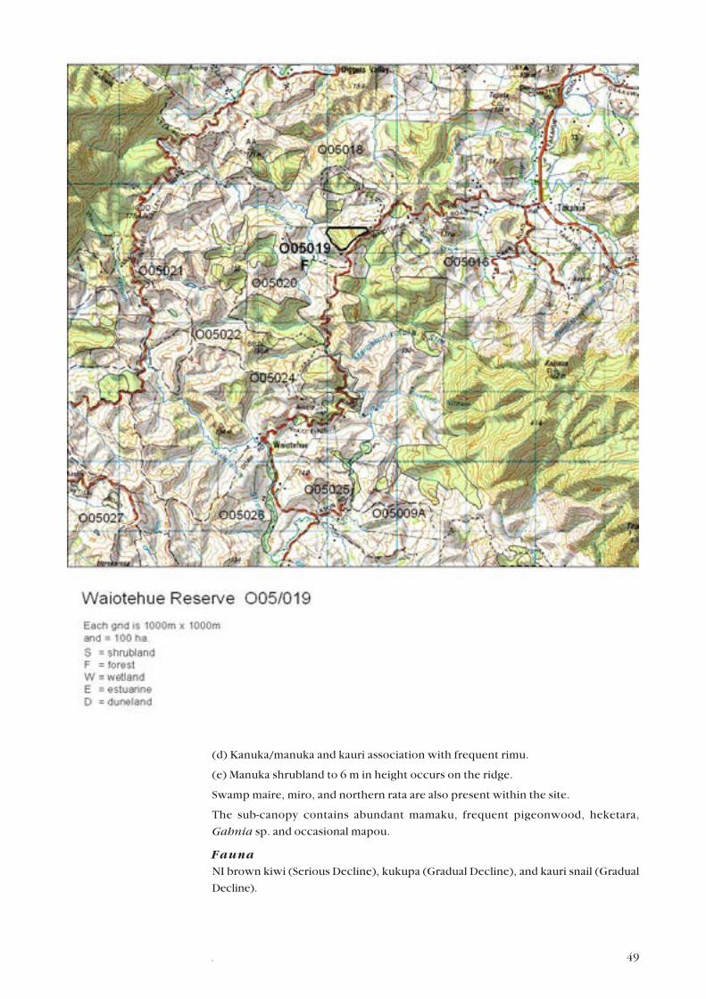
WAIOTEHUE RESERVE
Survey no. O05/019
Survey date 18 November 1994
Grid reference O05 392 662
Area 12 ha
Altitude 60–120 m asl
Ecological unit(a) Taraire secondary forest on hillslope (25%)
(b) Kahikatea secondary forest on ridge (20%)
(c) Kahikatea–towai secondary forest on ridge (20%)
(d) Kanuka/manuka–kauri forest on ridge (25%)
(e) Manuka shrubland on ridge (10%)
Landform/geologyDissected hill country on Mangakahia Complex siliceous mudstone.
VegetationA mosaic of vigorous secondary growth.
(a) Abundant taraire with frequent towai and scattered kauri, puriri, rimu, kahikatea,
totara, rewarewa, kawaka and pukatea.
(b) Abundant kahikatea with occasional rewarewa, towai, rimu and mamaku.
(c) Towai and kahikatea are common with frequent kanuka and occasional puriri,
kauri, rimu and totara.
49.
(d) Kanuka/manuka and kauri association with frequent rimu.
(e) Manuka shrubland to 6 m in height occurs on the ridge.
Swamp maire, miro, and northern rata are also present within the site.
The sub-canopy contains abundant mamaku, frequent pigeonwood, heketara,
Gahnia sp. and occasional mapou.
FaunaNI brown kiwi (Serious Decline), kukupa (Gradual Decline), and kauri snail (Gradual
Decline).
50 .
SignificanceRepresentative site for vegetation types (a) to (d) showing excellent examples of
secondary broadleaf–podocarp–kauri forest types and the only kanuka/manuka–
kauri forest, type (d), vegetation type recorded in the Ecological District.
Presence of threatened species.
The Department of Conservation administers 11 ha of Stewardship Land within this
site.
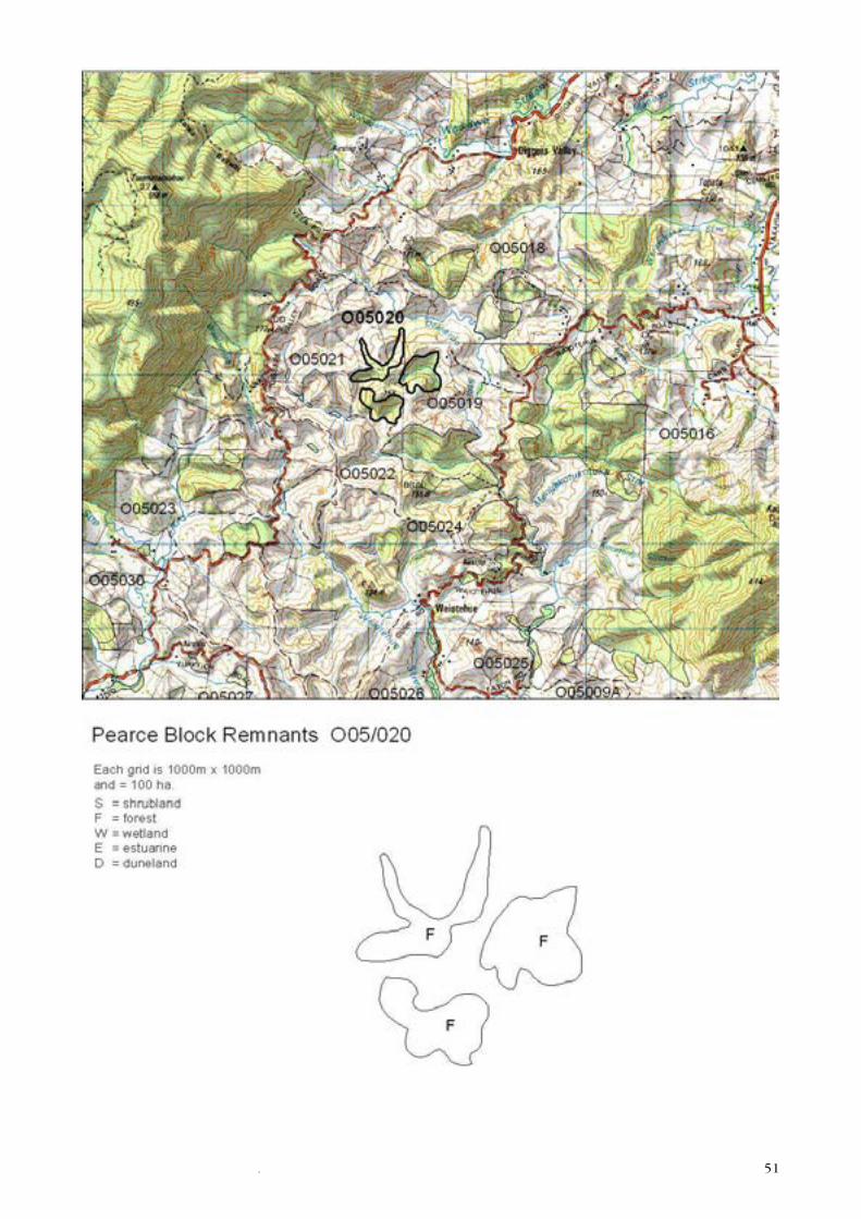
PEARCE BLOCK REMNANTS
Survey no. O05/020
Survey date 20 December 1994
Grid reference O05 377 662
O05 380 660
O05 375 656
Area 41 ha
Altitude c. 60–120 m asl
Ecological unit(a) Taraire forest on hillslope
(b) Kahikatea–taraire forest on hillslope
(c) Kahikatea–puriri forest on hillslope
(d) Taraire-towai forest on hillslope
(e) Kanuka–towai forest on hillslope
(f) Taraire-towai forest on hillslope
Landform/geologyValley wetlands and ponds in an area of Mangakahia complex sandstone.
VegetationA series of broadleaf–podocarp remnants around which pines have recently been
planted (1994–1995).
(a) The northern block is mostly taraire-dominant with frequent puriri and kahikatea.
Also occurring are towai, nikau, mamaku, rewarewa, rimu, pukatea, northern rata
and kauri.
(b) About 5% of the area is kahikatea and taraire forest with occasional nikau, ti
kouka, towai and totara.
(c) The western block is kahikatea and puriri with frequent taraire and occasional
nikau, rewarewa, rimu, northern rata, totara and kauri.
(d) Around 90% of the eastern block is taraire and towai forest with frequent
kahikatea and occasional rimu, northern rata, rewarewa, and puriri.
(e) The remaining area is towai and kanuka with frequent rimu and occasional kauri,
northern rata and rewarewa.
(f) The southern block is taraire and towai with occasional northern rata, puriri,
rewarewa, kohekohe, mamaku, rimu, kahikatea, totara and macrocarpa.
Significant flora
Pittosporum virgatum (Sparse) recorded from this site in 1986.
51.
52 .
FaunaNot surveyed by the Department of Conservation. NI brown kiwi (Serious Decline)
has been reported from this site.
SignificanceHabitat for kiwi.
These are remnants providing potential seasonal food source for kukupa and a
corridor between Herekino and Raetea Forests via pine plantations. The remnants
may provide a refuge for fauna during plantation harvesting.
Representative site for type (c) kahikatea–puriri forest and the only example of its
type recorded in the Ecological District.
A Department of Conservation Conservation Covenant protects 13.8 ha of this site.
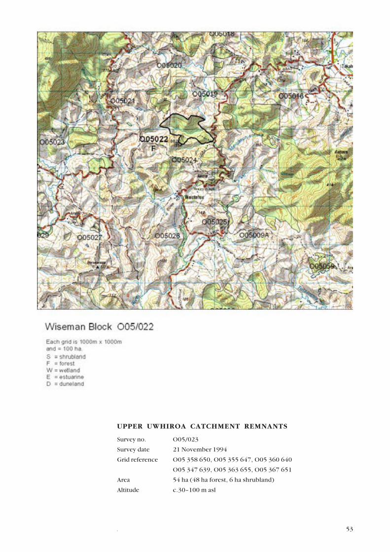
WISEMAN BLOCK
Survey no. O05/022
Survey date 18 November 1994
Grid reference O05 382 650
Area 61 ha
Altitude c.50–120 m asl
Ecological unit(a) Taraire-towai forest on hillslope
(b) Kahikatea secondary forest on toeslope
(c) Raupo reedland in valley bottom
Landform/geologyDissected hill country on Mangakahia Complex sandstone.
Vegetation(a) A large area of tall forest in which taraire and towai are common. Scattered
throughout are totara, kahikatea, tawa, pukatea, rewarewa, puriri, kauri, miro, nikau
and emergent rimu and northern rata.
(b) In lower sites there are pockets of kahikatea. Ponga, nikau, kiekie and kohekohe
occur in gullies.
(c) In the valley there is a marshy stream containing raupo, sedges and rushes, with
wineberry and kotukutuku.
FaunaKukupa and kauri snail (both Gradual Decline). NI brown kiwi (Serious Decline) has
been reported at this site.
SignificanceA large, diverse area with a good range of age classes including emergents.
Presence of three threatened species.
Representative site for type (a) taraire–towai forest.
A Department of Conservation Covenant protects 31.4 ha of this site.
53.
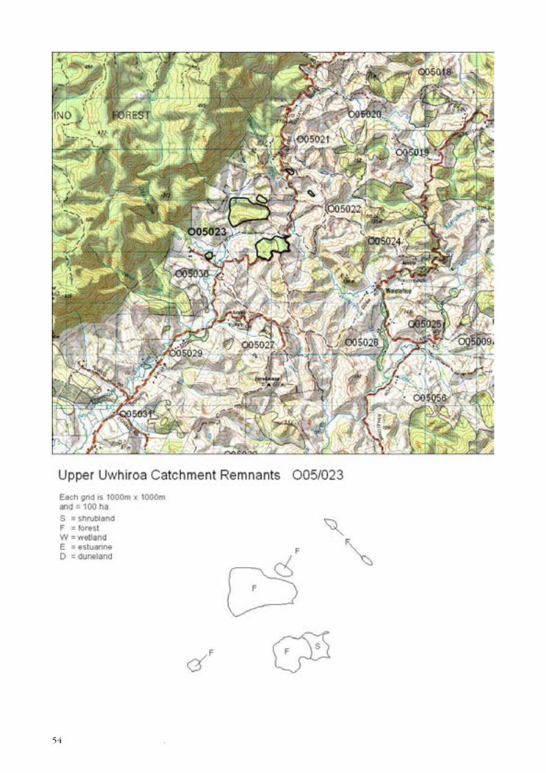
UPPER UWHIROA CATCHMENT REMNANTS
Survey no. O05/023
Survey date 21 November 1994
Grid reference O05 358 650, O05 355 647, O05 360 640
O05 347 639, O05 363 655, O05 367 651
Area 54 ha (48 ha forest, 6 ha shrubland)
Altitude c.30–100 m asl
54 .
55.
Ecological unit(a) Northern rata–taraire forest on hillslope
(b) Taraire forest on hillslope
(c) Manuka–totara–towai forest on hillslope
(d) Manuka–totara shrubland on hillslope
(e) Manuka shrubland on hillslope
(f) Towai shrubland on hillslope
(g) Kahikatea–taraire forest in gully
Landform/geologyDissected hill country including headwater catchments on Mangakahia Complex
sandstone.
VegetationTwo main bush areas and four small outlying remnants.
(a) The largest area of bush consists mainly (80%) of tall northern rata and taraire
forest and frequent kahikatea. Other species present are tawa, miro, rewarewa,
nikau, mahoe, pigeonwood, towai, rimu, totara, kauri and pukatea.
(b) In about 10% of this remnant, taraire is common with kauri frequent. Totara,
rimu, rewarewa, and kahikatea are occasional.
(c) Manuka, totara and towai occurs in about 10% of the remnant with occasional
mamaku and rewarewa.
Type (b), taraire forest, occurs in about 60% of the southern remnant alongside
Diggers Valley Rd. A range of species are occasional including rewarewa, nikau, tawa,
rimu, pukatea, puriri, totara, kahikatea, towai, kohekohe, northern rata and
epiphytic puka.
A mosaic of regeneration occurs on the northern end of this remnant including:
(d) Manuka and totara shrubland with frequent towai and occasional ti kouka and
rewarewa.
(e) Manuka shrubland between 3–6 m with scattered mamaku, rewarewa, and pate.
(f) Further up Diggers Valley Rd, on the opposite side is a fenced area of towai
shrubland.
(g) In a gully to the east is a tiny kahikatea and taraire remnant in which kukupa have
been reported to nest.
To the south on the edge of Otangaroa Stream is a very small taraire remnant, type
(b), which contains occasional pukatea, rewarewa, towai, kahikatea, totara and
kowhai.
FaunaKukupa (Gradual Decline) and NI brown kiwi (Serious Decline) has been reported at
this site.
SignificanceRepresentative site for type (a) which is unrecorded elsewhere in the Ecological
District and type (c). Habitat for threatened species.
A Queen Elizabeth II National Trust covenant protects 31.3 ha in the large northern
remnant and 22.7 ha in the main southern remnant.
56 .
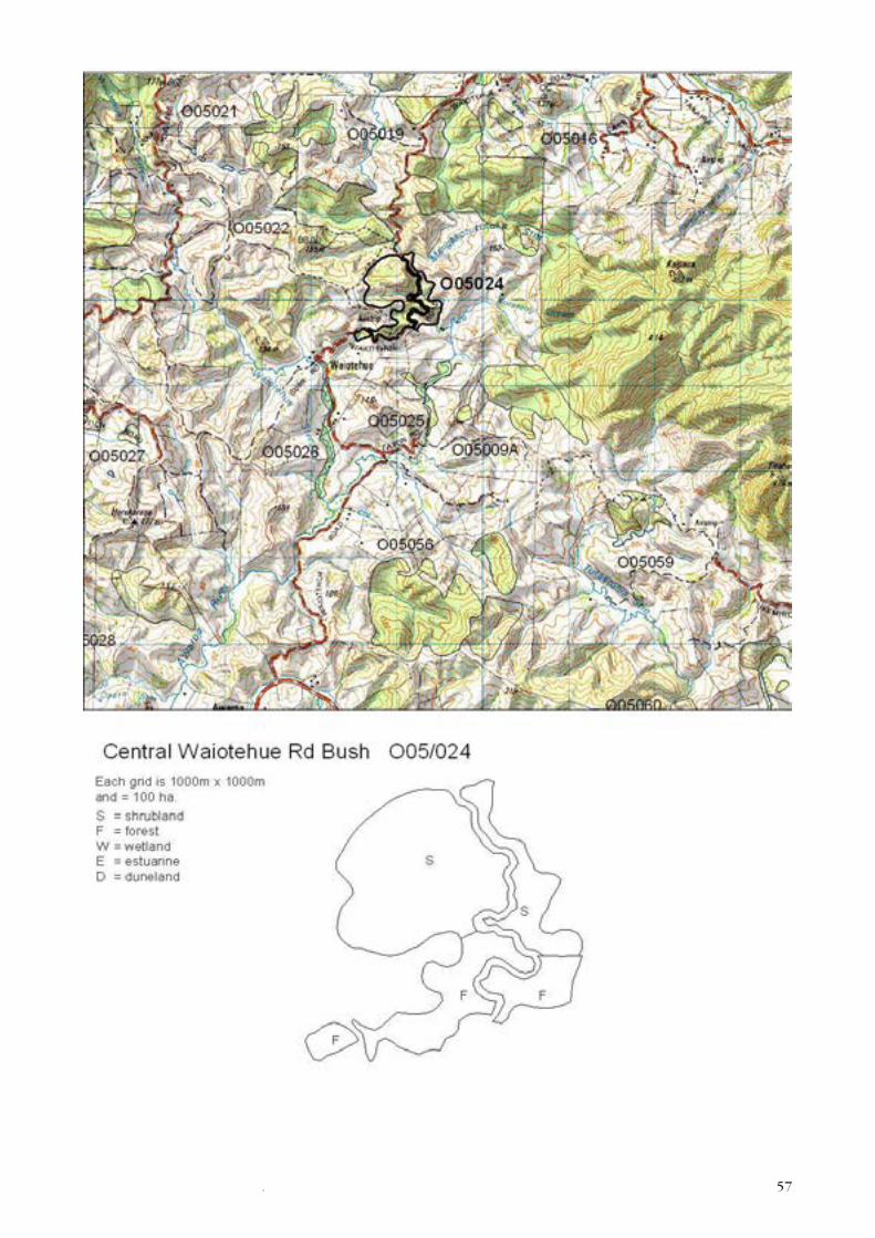
CENTRAL WAIOTEHUE RD BUSH
Survey no. O05/024
Survey date 18 November 1994
Grid reference O05 390 640
Area 51 ha (16 ha forest, 35 ha shrubland)
Altitude 40–120 m asl
Ecological unit(a) Manuka shrubland on moderate to steep hillslope
(b) Kanuka/manuka–ring fern association on moderate to steep hillslope
(c) Towai shrubland on moderate to steep hillslope
(d) Kanuka–towai shrubland on moderate to steep hillslope
(e) Taraire forest on moderate to steep hillslope
(f) Towai secondary forest on moderate to steep hillslope
(g) Kahikatea–totara secondary forest on moderate hillslope
Landform/geologyDissected hill country on Mangakahia Complex sandstone.
VegetationA mosaic of regeneration with pockets of broadleaf forest.
(a) The northern area consists mostly of manuka shrubland between 1–6 m tall with
frequent mamaku, towai, and bracken and occasional totara and pampas.
(b) On the eastern side of the road is low kanuka and manuka with ring fern, bracken
is frequent and mamaku occasional.
(c) Tall towai shrubland also occurs here with frequent ring fern, kanuka, and
occasional mamaku and mahoe.
(d) Dropping steeply from the road, kanuka and towai shrubland occurs with
occasional puriri, ti kouka, nikau, wheki, mamaku and rewarewa.
(e) Taraire with frequent towai also occurs here with scattered pukatea, rewarewa,
puriri, kahikatea and tawa.
(f) Secondary towai with occasional rewarewa, kauri, totara and mamaku also occurs
on the western side of the road.
(g) Across the road a small area of secondary kahikatea and totara occurs with
frequent manuka and occasional puriri, towai and pukatea.
FaunaNot surveyed by the Department of Conservation. NI brown kiwi (Serious Decline)
has been reported from this site.
SignificanceVegetation on steep areas above streams is providing aquatic habitat protection.
Presence of a threatened species.
Representative site for type (c) and only record of type (b) and (d) in the Ecological
District.
57.