Embed Size (px)
Citation preview

3D-RTK CAPABILITY OF SINGLE GNSS RECEIVERS
W. Stempfhuber
Beuth Hochschule für Technik Berlin, University of Applied Sciences
KEY WORDS: Low Cost, GNSS, Single Frequency, Carrier Phase Ambiguity Resolution, 3D-Positioning
ABSTRACT:
Small, aerial objects are now being utilised in many areas of civil object capture and monitoring. As a rule, the standard application
of a simple GPS receiver with code solutions serves the 3D-positioning of the trajectories or recording positions. Without GPS
correction information, these can be calculated at an accuracy of 10-20 metres. Corrected code solutions (DGPS) generally lie in the
metre range. A precise 3D-positioning of the UAV (unmanned aerial vehicle) trajectories in the centimetre range provides significant
improvements. In addition, the recording time of each sensor can be synchronized with the exact time stamp of the GNSS low-cost
system.
In recent years, increasing works on positioning from L1 GPS raw data have been published. Along with this, the carrier phase
measurements with the established evaluation algorithms are analysed in the post processing method to centimetre-exact positions or
to high-precision 3D trajectories [e.g. Schwieger and Gläser, 2005 or Korth and Hofmann 20011]. The use of reference information
from local reference stations or a reference network serves the purpose of carrier phase ambiguity resolution. Furthermore, there are
many activities worldwide in the area of PPP techniques (Precise Point Positioning). However, dual frequency receivers are
primarily used in this instance. Moreover, very long initialisation times must be scheduled for this.
A research project on the subject of low-cost RTK GNSS was developed for real-time applications at the Beuth Hochschule für
Technik Berlin University of Applied Sciences [Stempfhuber 2012]. The overall system developed for the purpose of real-time
applications with centimetre accuracy is modularly constructed and can be used for various applications (http://prof.beuth-
hochschule.de/stempfhuber/seite-publikation/). With hardware costing a few hundred Euro and a total weight of 500-800g (including
the battery), this system is ideally suited for UAV applications. In addition, the GNSS data processed with the RTK method can be
provided in standardised NMEA format. Through the reduced shadowing effects of the aerial objects, GNSS external factors such as
multipath cause few problems. With L1 carrier phase analysis, the baseline computation must nevertheless remain limited at the
range of a few kilometres. With distances of more than 5 kilometres between the reference station and the rover station position,
mistakes arise in the decimetre area.
The overall modular system consists of a low-cost, single-frequency receiver (e.g. uBlox LEA4T or 6T receiver), a L1 antenna (e.g.
the Trimble Bullet III), a developed data logger including an integrated WLAN communication module for storage and securing of
the raw data as well as a power supply. Optimisation of the L1 antenna has shown that, in this instance, many problems relating to
signal reception can be reduced. A calibration of the choke-ring adaptors for various antenna calibration facilities results in good and
homogeneous antenna parameters. In this situation, the real-time algorithm from the Open Source project RTKLib [Takasu, 2010]
generally runs on a small computer at the reference station. In this case, the data transfer from the L1 receiver to the PC is realisable
through a serial cable. The rover station can transfer the raw data to the computing algorithm over a WLAN network or through a
data radio. Of course, this computational algorithm can also be adapted to an integrated computing module for L1 carrier phase
resolutions. The average time to first fix (TTFF) amounts to a few minutes depending on the satellite constellation. Different test
series in movement simulators and in moving objects have shown that a stable, fixed solution is achieved with a normal satellite
constellation. A test series with a Microdrones quadrocopter could also be conducted. In comparison of the RTK positions with a
geodetic dual frequency receiver, differences are in millimetre ranges. In addition, reference systems (based on total stations) are
present for the precise examination of the kinematically captured positioning [Eisenbeiss et al. 2009].
1. Introduction
Unmanned aerial vehicles (UAVs) register data capture (as a
general rule, aerial images) from a planned flight route. Single-
frequency GPS receivers are primarily used in the course of
this. These 3D flight trajectories can be determined from the
analysed L1 code observations from about 10-20 metres and
with differential code observations from 0,5 – 3,0 metres of
position accuracy. For DGPS applications, there are many free
and purchasable Ground-Based Augmentation Systems (in
Germany, e.g., Sapos EPS, Beacon, Egnos, etc.). These
processes are clearly listed in Augath et al. 2000. Real-time
kinematic GNSS processes are able to capture 3D trajectories
centimetre-exactly. For real-time applications in the centimetre
range, carrier phase ambiguities must be resolved. This has been
conducted in geodesy with multi-frequency receivers for many
years. Nevertheless, research projects with low-cost receivers
(L1, GPS, single-frequency receivers) show that with normal
satellite conditions (minimal shadowing effects, minimisation of
disturbing influences and a satellite count of 5-6), centimetre-
exact 3D positions with static position data [e.g., Glabsch, et al.
2009] as well as with kinematic position data [Stempfhuber,
2011] are achieved on a real-time basis. 3D trajectories with
real-time applications, e.g., the navigation of moving objects,
are therefore available in standardised NMEA output format
0183 (www.nmea.de). In addition, such a process delivers an
absolute time reference for the synchronisation of various
measuring sensors and capture sensors. The time impulse noise
International Archives of the Photogrammetry, Remote Sensing and Spatial Information Sciences, Volume XL-1/W2, 2013UAV-g2013, 4 – 6 September 2013, Rostock, Germany
This contribution has been peer-reviewed. 379
PPS (Pulse per Second Process) amounts to a few s in the
complete system.
Many geodetic applications require an exact and cost-efficient
measuring system for the capture of absolute 2D or 3D point
coordinates with zenith metre accuracy on a real-time basis.
Additionally, the latency periods should only amount to a few
milliseconds. Moreover, the complete measuring equipment
with many applications should have a low weight and use little
power. This is also the case with UAV utilisation (Unmanned
Aerial Vehicle). At the Beuth University of Applied Sciences, a
GNSS RTK low-cost system (real time kinematic) has been
developed and optimised for some years. Various test
measurements and field applications have shown that this
approach can be also deployed for exact positioning with UAV
applications. For the improvement and optimisation of a low-
cost GNSS system, it not only makes sense to use a GPS
receiver with the L1 frequency 1,575.42 MHz (e.g., ublox
receiver Lea4/6T), but also GLONASS (satellite-dependent
frequency of 1598-1605 MHz) and Galileo receivers with the
E1 frequency (identical to the L1 GPS frequency). For example,
this boards ublox Lea7N or Navis can process GPS L1 and
Glonass L1 frequencies. Aside from the receivers, an algorithm
including the hardware communication must be available for the
real time analysis of the raw data. Additionally alongside the
general GNSS magnitudes of influence, the special factors and
occurrences are to be particularly observed with UAV
applications. This was and is more precisely processed in
various assignments and in a research project (cf. Research
Assistance VI at the Beuth University of Applied Sciences). A
minimisation of the hardware weight and the intelligent
integration of the complete system in the aerial object are
further targeted. The stability of the carrier phase ambiguity
solution of the baseline analysis must also be intensely analysed
for this. The maximum ranges of data transmission between the
Rover station and base station as well as the processing unit are
to be additionally considered. In this instance, an interference-
free communication between the individual components is to be
kept in mind. The storage of the GNSS raw data in standardised
RINEX format must be ensured for later data analyses in the
post-processing analysis.
The present GNSS RTK Low-cost System at the Beuth
University of Applied Sciences consists of a flexible
construction. With this, the individual components can be freely
adapted and assembled. At the moment, the GNSS reference
and Rover unit can be operated with different low-cost boards
such as ublox, Sky Traq, NovaTel, Hemisphere and Superstar.
The implementation and analysis of other GNSS boards is
targeted. Very good results have been achieved in the past with
the ublox receivers Lea 4T and 6T (L1 GPS receiver). New
ublox Lea 7 generations also use the L1 frequency of the
GLONASS satellites and can also use the E1 frequency of the
Galileo satellites. Regional satellite navigation systems such as
QZSS or Compass are not considered in this article. The
receivers mentioned can be operated with different low-cost
antennas and also with geodetic antennas, if necessary. The very
light ublox ANN-MS Antenna was little considered in the
previous work. Very good results could be achieved with the
Trimble Bullet III Antenna, among others. Interference signals
could be extensively minimised through its own choke ring
construction (figure 1). This antenna construction was assessed
in different assignments and calibrated on the calibration
facilities of the Berlin Senate Administration and the University
of Technology of Dresden [Carius, 2011 or Stempfhuber, 2012].
The homogeneous antenna models demonstrate this approach.
An identical receiver system can be used as a local reference
system. In this instance, very good absolute accuracy and nearly
100% ambiguity resolution is achieved through short baselines.
With a cold start, the initialization time (Time to First Fix,
TTFF) amounts to a few minutes. With this, the raw data is
processed through the company internal data formats in the
GNSS data analysis software (with the ublox receiver, a binary
format with the name, ubx). The services for RTCM correction
signals from GNSS correction services can also be used (in
Germany, for the carrier phase solutions with the services of the
surveying authorities, SAPOS, Trimble VRSNow, AXIO-Net
ascos and Leica SmartNet, distributed over the NTRIP Process).
In this instance, the quality and stability of the network
solutions based on multi-frequency receivers (RTCM Standard
3.1 in the MAC process) must be separately examined. With
this, the baselines should only amount to a few kilometres.
Investigations of the influence of the baseline length on the
carrier phase solutions with GPS L1 receivers proved that from
a distance of approximately 3-5 km, the position accuracy of 1-
3 cm became significantly worse. At the moment, the maximum
measuring and analysis frequency of the system with ublox Lea
6T receivers amounts to 10 hz. The main component at this
approach is based on the open source project RTKLib
[www.rtklib.com; Takasu, 2009]. The open source platform
provides following subsystems:
RTKNavi Real time kinematic GNSS
Algorithm (NMEA export)
RTKPost Post-processing algorithm
RTKPlot Visualisation
RTKConv RINEX converting tool
RTKNavi delivers real-time positions in the accuracy range of a
few centimetres. With RTKPost, the recorded raw data can be
post-processed in the format of the above-mentioned receiver or
in RINEX format. Playing back the raw data with variable
configuration settings of the baseline calculation and position
outputs in a serial interface can also be very helpful tools.
Another component displays the communication between the
receivers and the calculation software. A developed WLAN
module establishes a wireless connection to the Rover unit
through an ad hoc network. The real-time positions and the
time stamp of the measurement are on the processing unit that,
in the past, was primarily directly connected to the local
reference station with a cable. Ranges of some hundred metres
can be achieved through optimised WLAN broadcasting
antennas. Another communication possibility arises over a data
broadcast modem (e.g., Satelline 3ASx). Data transmission
through the mobile Internet (via an Android Smartphone) is
currently being developed. The modular construction of the
complete system is as follows (weight according to
configuration, including battery, approximately 500-800g).
International Archives of the Photogrammetry, Remote Sensing and Spatial Information Sciences, Volume XL-1/W2, 2013UAV-g2013, 4 – 6 September 2013, Rostock, Germany
This contribution has been peer-reviewed. 380

Figure 1, Overall Low-cost RTK GNSS System
3. RTK Low-cost GNSS Applications
The L1 low-cost RTK system described in the preceding
paragraph is based on a functional platform and can be easily
deployed for the most varied of applications. Up to now, the
geodetic applications have been in the following areas:
Post-processing
In this case, low-cost GNSS receivers are particularly well-
suited for the processing of raw data (RINEX data). The data
analysis system can conduct the raw data analysis classically as
a baseline analysis or with an automated batch file or by
introducing the real-time data directly into the data analysis
system. The system construction is, among other items,
described in [Stempfhuber, 2012]. Moreover, the individual
receiver components and the complete system are currently
being examined in different dissertations, particularly for
interference influence, response time and long-term stability.
Navigation and Machine Control and Guidance
Up to now, simulations of different tasks by the machine
guidance system and for the navigation of precision farming
applications have been simulated, recorded and analysed
particularly with Mindstorms NXT components. A complete
system construction with absolute position comparison between
the RTK low-cost system and a reference from a destination-
total station (cf. Section 4) has been analysed. It is based on the
approach of Figure 3. The first results in a movement simulator
were published [Stempfhuber, 2011].
Figure 2, 3D-Navigation with the Low-cost RTK GNSS System
at a Reference Track
International Archives of the Photogrammetry, Remote Sensing and Spatial Information Sciences, Volume XL-1/W2, 2013UAV-g2013, 4 – 6 September 2013, Rostock, Germany
This contribution has been peer-reviewed. 381

UAV Applications
The first tests were conducted in a Quadrocopter from the firm,
Microdrones, at the airfield in Stendal with the firm, Geo-
Metric (Fig. 3). With this, it was demonstrated that the data
broadcast used with the ad hoc WLAN only reaches to
approximately 150 m. Nevertheless, the raw data analysis
proved a 100% fixed solution of the carrier phases. Testing was
conducted here with the above-mentioned antennas (ANN from
ublox and Trimble Bullet III). A position plot shows the high-
precision flight trajectory.
Figure 3, UAV GNSS 3D-Navigation (Comparison: Standard
UAV GPS with the L1 RTK GNSS System)
Standard Surveying
A system is currently being constructed that, based on the
described components, facilitates a simple Rover system in
point capture and surveying. The approach of the complete
system has already delivered the first positive test results. This
approach is a reasonable and easy alternative for the capture of
pass points in photogrammetric analyses or reference data with
centimetre-exact demands on a classic RTK GNSS multi-
frequency system.
Figure 4, L1 RTK GNSS Rover System, e.g. Ground Control
Point Acquisition
For an UAV application of the measuring system, the following
subsidiary tasks must still be processed in greater detail:
precise definition of the UAV 3D trajectory
applications
(speed, factors, accelerations, distances to the GNSS
reference station)
Integration of GLONASS receivers
Integration of the software including the
communication
adjustment of processing parameters and real-time
filters
evaluation of general parameters and the UAV
application factors
analysis of 3D residual
PPS event for of sensor synchronization
Optimization of the overall system
International Archives of the Photogrammetry, Remote Sensing and Spatial Information Sciences, Volume XL-1/W2, 2013UAV-g2013, 4 – 6 September 2013, Rostock, Germany
This contribution has been peer-reviewed. 382
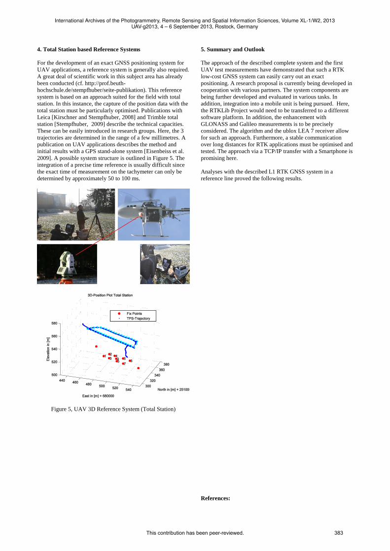
4. Total Station based Reference Systems
For the development of an exact GNSS positioning system for
UAV applications, a reference system is generally also required.
A great deal of scientific work in this subject area has already
been conducted (cf. http://prof.beuth-
hochschule.de/stempfhuber/seite-publikation). This reference
system is based on an approach suited for the field with total
station. In this instance, the capture of the position data with the
total station must be particularly optimised. Publications with
Leica [Kirschner and Stempfhuber, 2008] and Trimble total
station [Stempfhuber, 2009] describe the technical capacities.
These can be easily introduced in research groups. Here, the 3
trajectories are determined in the range of a few millimetres. A
publication on UAV applications describes the method and
initial results with a GPS stand-alone system [Eisenbeiss et al.
2009]. A possible system structure is outlined in Figure 5. The
integration of a precise time reference is usually difficult since
the exact time of measurement on the tachymeter can only be
determined by approximately 50 to 100 ms.
Figure 5, UAV 3D Reference System (Total Station)
5. Summary and Outlook
The approach of the described complete system and the first
UAV test measurements have demonstrated that such a RTK
low-cost GNSS system can easily carry out an exact
positioning. A research proposal is currently being developed in
cooperation with various partners. The system components are
being further developed and evaluated in various tasks. In
addition, integration into a mobile unit is being pursued. Here,
the RTKLib Project would need to be transferred to a different
software platform. In addition, the enhancement with
GLONASS and Galileo measurements is to be precisely
considered. The algorithm and the ublox LEA 7 receiver allow
for such an approach. Furthermore, a stable communication
over long distances for RTK applications must be optimised and
tested. The approach via a TCP/IP transfer with a Smartphone is
promising here.
Analyses with the described L1 RTK GNSS system in a
reference line proved the following results.
References:
International Archives of the Photogrammetry, Remote Sensing and Spatial Information Sciences, Volume XL-1/W2, 2013UAV-g2013, 4 – 6 September 2013, Rostock, Germany
This contribution has been peer-reviewed. 383

Augath, W., Lechner, W., Peters, R. (2000): Combination of
DGPS and LORAN-C for Users on the 1-3 m-Level. DGON-
Symposium 2000, Bonn.
Carius R.: Untersuchungen zur Kalibrierung von GPS-
Antennen, Diplomarbeit an der Beuth Hochschule für Technik
Berlin, unveröffentlicht 2011.
Glabsch J., Heunecke O. und Schuhbäck S.:
Hangüberwachungen mittels Low Cost GNSS im alpinen Raum
- Ansätze und Erfahrungen, ETH Zürich, AHORH 2009.
Eisenbeiss, H. Stempfhuber, W. and Kolb, M.:
Genauigkeitsanalyse der 3D-Trajektorie von Mini-UAVs,
Tagungsband der Deutschen Gesellschaft für Photogrammetrie
und Fernerkundung (DGPF) 18/2009.
Kirschner H. and Stempfhuber W., The Kinematic Potential of
Modern Tracking Total Stations - A State of the Art Report on
the Leica TPS1200+, In: Stempfhuber, W and Ingensand, H. [Eds.], MCG-Proceedings, pp. 51-60, 2008.
Korth, W. und Hofmann, U.: Softwareentwicklung für
Positionsbestimmung mit Satelliten, Abschlussbericht
Forschungsassistenz VI, www.beuth-hochschule.de, 2011.
Schwieger, V. and Gläser, A.: Possibilities of Low Cost GPS
Technology for Precise Geodetic Applications. Proceedings on
FIG Working Week 2005, Kairo, 2005.
Stempfhuber W.: Verification of the Trimble Universal Total
Station (UTS) Performance for Kinematic Applications, In:
Grün/Kahmen (Eds), Optical 3-D Measurement Techniques
IX, 2009, Vienna, FIG Commission 5 and 6, IAG Special
Commission 4, ISPRS Commission 5, pp. 211-221, 2009.
Stempfhuber, W. and Buchholz; M.: A Precise, Low-Cost RTK
GNSS System for UAV Applications, ISPRS Archives
XXXVIII-1/C22 with ISSN Number: 1682-1777, 2011. Stempfhuber W. und Alberding J.: Geodätische
Monitoringsysteme mit RTK Low-Cost-GNSS, AVN
4/2012, VDE Verlag GmbH, 2012.
Stempfhuber, W., Leistungsfähigkeit von Low-Cost RTK
GNSS-Systemen zur genauen Positionsbestimmung von UAV-
Anwendungen, 19. Workshop Computer-Bildanalyse in der
Landwirtschaft/2. Workshop Unbemannte autonom fliegende
Systeme (UAS) in der Landwirtschaft, Bornimer
Agrartechnische Berichte Heft 81, ISSN 0947-7314, 2013.
Takasu, T.: RTKLIB: Open Source Program Package for RTK-
GPS, FOSS4G 2009 Tokyo, Japan, November 2, 2009.
International Archives of the Photogrammetry, Remote Sensing and Spatial Information Sciences, Volume XL-1/W2, 2013UAV-g2013, 4 – 6 September 2013, Rostock, Germany
This contribution has been peer-reviewed. 384


![Air Receiver - EcoGuardmedia.ecoguard.se/2020/09/Air-Receiver-manual.pdfEcoGuard Air Receiver [2] Version 1.0 2019-01-09 Introduktion EcoGuard Air R eceiver är en insamlingsenhet](https://img.pdfslide.us/doc/110x75/6114293b13d6ab38a37fd963/air-receiver-ecoguard-air-receiver-2-version-10-2019-01-09-introduktion-ecoguard.jpg)