Embed Size (px)
Citation preview
3D RECONSTRUCTION WITH A COLLABORATIVE APPROACH
BASED ON SMARTPHONES AND A CLOUD-BASED SERVER
E. Nocerino a, F. Poiesi b, A. Locher c, Y. T. Tefera b, F. Remondino a, P. Chippendale b, L. Van Gool c
a 3D Optical Metrology (3DOM) unit, Bruno Kessler Foundation (FBK), Trento, Italy
Email: (nocerino, remondino)@fbk.eu b Technologies of Vision (TeV) unit, Bruno Kessler Foundation (FBK), Trento, Italy
Email: (poiesi, tefera, chippendale)@fbk.eu c Computer Vision Lab, ETH Zurich, Switzerland - Email: (alocher, vangool)@vision.ee.ethz.ch
Commission II
KEY WORDS: smartphone, 3D reconstruction, low-cost, collaborative, SfM, photogrammetry, dense image matching.
ABSTRACT:
The paper presents a collaborative image-based 3D reconstruction pipeline to perform image acquisition with a smartphone and
geometric 3D reconstruction on a server during concurrent or disjoint acquisition sessions. Images are selected from the video feed of
the smartphone’s camera based on their quality and novelty. The smartphone’s app provides on-the-fly reconstruction feedback to
users co-involved in the acquisitions. The server is composed of an incremental SfM algorithm that processes the received images by
seamlessly merging them into a single sparse point cloud using bundle adjustment. Dense image matching algorithm can be lunched
to derive denser point clouds. The reconstruction details, experiments and performance evaluation are presented and discussed.
1. INTRODUCTION
Image-based approaches have become viral for 3D digitization in
the last years. Requirements and needs of digital replica
significantly change according to the application field, steering
the choice of equipment, as well as software tools. In industrial
metrology, accuracy and reliability are crucial factors, which
imply the adoption of high-cost, professional-grade camera and
lens systems, coupled with software applications fully
manageable only by expert operators. In the geospatial domain,
completeness of the results, accuracy of georeferencing, handling
of huge amount of data, reliability and speed of automatic
procedures, integration and homogenization of data from
different sources are key topics. Researches and studies in the
cultural heritage field specifically focus, among other topics, on
colour fidelity, geometric level of details, handling, visualization
and sharing of 3D models.
Today, a range of economic activities, whose origin can be traced
back to the beginning of the new millennium, is driving the
digital economy all around the word, i.e. the creative industries
(EY, 2015). Also referred to as ‘creative and cultural industries’
or ‘creative and digital industries’, they embrace thirteen sub-
sectors: advertising, architecture, arts and antiques market; crafts;
design; designer fashion; film and video; music; performing arts;
publishing; interactive leisure and software; software and
computer services; television and radio (Skillset, 2013). People
working in the creative economy rely on their individual
creativity, skill and talent, to produce economic values.
To answer the needs of this growing community, technologies
and tools are rapidly developing and changing. Emblematic is the
progress of 3D printers, more and more used to realise fully-
operational, market-ready products rather than quick and cheap
prototypes (The Economist, 2011). Similarly, we are witnessing
a ‘democratization’ and massive spread of 3D digitization
techniques (Alderton, 2016; Nancarrow, 2016; Santos et al.,
2017), with an increasing demand for hardware and software
solutions economically accessible, easily understandable and
manageable by almost anyone wills to express his or her
creativity through 3D digital products.
1 https://itseez3d.com, last accessed: Oct 2017.
The work described in this paper arises in this context and
presents a collaborative image-based 3D digitization pipeline.
Different users acquire – simultaneously or in separate sessions
– images with their smartphones and images are then 3D
processed via a cloud-based server. A smartphone’s app provides
on-the-fly visual feedback about the 3D reconstruction to users
co-involved in the digitization process. The idea is to (i) guide
users during the image acquisitions and (ii) combine images from
multiple devices from concurrent or disjoint acquisition sessions.
The developed approach (Poiesi et al. 2017) and the achieved
results, produced in real-world scenarios (i.e. a cultural heritage
site and a city square), are compared against reference data,
produced employing a professional-grade reflex camera and
state-of-the-art image processing software solutions.
2. RELATED WORKS AND MAIN INNOVATIONS
Image-based 3D reconstruction methods using mobile devices
have been pioneered in the research domain (Tanskanen et al.,
2013; Kolev et al., 2014; Muratov et al., 2016), and are starting
to appear on app stores for smart devices (e.g., ItSeez3D1,
TRNIO2). These methods implement very similar workflows,
relying on Structure from Motion (SfM) and dense image
matching (DIM) or Multi View Stereo (MVS) algorithms, run
either on the phone or on a server. Being the 3D reconstruction
procedure computationally intensive, a feasible solution is to split
the process between the mobile device and the cloud-based server
(Untzelmann et al., 2013; Locher et al., 2016c). In this case, the
smartphone is used as imaging device to capture images of the
scene of interest, whereas the SfM and DIM steps are performed
on the server. Current 3D reconstruction solutions running on
smartphones only offer feedback to single users during image
acquisitions, and do not yet seamlessly include collaborative
approaches with simultaneous feedback to the multiple. The most
common solution for collaborative mapping, based either on
Simultaneous Localization and Mapping (SLAM) or SfM
approaches, is to produce separate maps that are finally fused
together (Forster et al., 2013; Untzelmann et al., 2013; Morrison
et al., 2016; Schmuck, 2017).
2 http://www.trnio.com, last accessed: Oct 2017.
The International Archives of the Photogrammetry, Remote Sensing and Spatial Information Sciences, Volume XLII-2/W8, 2017 5th International Workshop LowCost 3D – Sensors, Algorithms, Applications, 28–29 November 2017, Hamburg, Germany
This contribution has been peer-reviewed. https://doi.org/10.5194/isprs-archives-XLII-2-W8-187-2017 | © Authors 2017. CC BY 4.0 License.
187
Figure 1: Part of the entire REPLICATE workflow (from Nocerino et al, 2017) jointly performed on smart devices and a cloud-based server (left)
and the collaborative aspect of 3D digitization procedures presented in this article (right).
The procedure presented in this paper is based on an incremental
SfM approach (Schonberger and Frahm, 2016), which updates
and augments the global sparse 3D point cloud when a new image
is uploaded. From video acquired by different smartphones, only
significant frames are selected, sent to the server and process to
increment the sparse 3D reconstruction. The updated results
provide the user with visual feedback during the acquisition
process and are accessible both on the mobile app and on a web-
based visualization service developed on the server.
While the sparse reconstruction of the scene is computed on the
server and constantly updated when new images are sent via the
SfM procedure, the DIM step produces dense point clouds, made
available to the users on a web-based visualization window.
3. THE PROPOSED PIPELINE
The implemented approach is part of an image-based 3D
reconstruction workflow under development within the EU
funded H2020 project REPLICATE3 (Nocerino et al., 2017, Fig.
1). A smartphone app allows the image acquisition phase,
whereas the processing procedure is jointly performed on the
smartphone as well as on a server (Locher et al., 2016c).
3.1 Image acquisition app and device-server
communications
Each user running the smartphone app must first be authenticated
by the cloud service. A unique smartphone identifier (ID) is
assigned based on the user’s account credentials, the device’s
manufacturer, its model and operating system. The smartphone
app is used to acquire the video stream, extract the best frames
(Section 3.2) and send them to the server for the 3D
reconstruction procedure (Section 3.3) Accelerometer
measurements from the device’s Inertial Measurement Unit
(IMU) are also transmitted together with the images to aid pose
estimation and object reconstruction. Smartphone vibration is
implemented as haptic feedback to help the user to understand
whether the images are acquired correctly (i.e. the device motion
is not to fast).
Network communication between the reconstruction server and
device is bidirectional and asynchronous. The app offers a user
the option to start a new acquisition session or to update past
acquisitions with new images in case of collaborative approaches
(Section 3.4). To visualize updated point clouds as feedback, the
smartphone sends periodic requests to the server.
3 http://www.replicateproject.eu, last accessed: Oct 2017.
The remote server handles user authentication, processes the
images and generates updated results visualized by the device
app and web-based interface. The web page enables users to see
estimated camera positions and interact with the dense point
cloud. The user can share the reconstruction job via an email
option with other users, who become contributors. Contributors
can then increment the reconstruction of an object by uploading
more images of new acquisitions.
3.2 Image selection from smartphone’s video stream
Images are selected from the smartphone’s app based on both
their quality and on their novelty. The selection is based on the
computation of a frame’s sharpness and the number of new
features present (Sieberth et al., 2016). Hence, a ‘content rich’
frame should be sharp (i.e. in focus and with no motion blur) and
it should contain new visual information about the object.
Newness is quantified by comparing current feature points with
those extracted from previous frames. The quantification of the
overlap is calculated for pairs of frames and by using ORB
keypoints (Rublee et al., 2011). The image overlap is inferred by
matching descriptors among adjacent frames based on the
Hamming distance. If no frames were selected for a certain
minimum interval of time, a frame is transmitted anyway.
3.3 Orientation and 3D reconstruction
The 3D reconstruction server adopts an incremental SfM
algorithm followed by the DIM step, using multiple threads to
process independent and asynchronous uploads of images from
different users. Two pipelines are under testing: the first,
described in Poiesi et al. (2017) and Nocerino et al. (2017) is
based on approaches proposed by Sweeney et al. (2015),
Schonberger et al. (2016), Locher et al. (2016a) and Locher et al.
(2016b). The second procedure, hereafter presented, follows the
SfM/DIM pipeline presented by Schonberger and Frahm (2016).
3.4 Collaborative approach
The developed method includes also a collaborative 3D
reconstruction which allows the processing of images coming
from multiple smartphone devices during concurrent or disjoint
acquisition sessions.
For each new image uploaded to the server, the algorithm
matches news computed features to those from a subset of images
acquired within the same acquisition job. This subset is
composed of images already stored in the database featuring high
The International Archives of the Photogrammetry, Remote Sensing and Spatial Information Sciences, Volume XLII-2/W8, 2017 5th International Workshop LowCost 3D – Sensors, Algorithms, Applications, 28–29 November 2017, Hamburg, Germany
This contribution has been peer-reviewed. https://doi.org/10.5194/isprs-archives-XLII-2-W8-187-2017 | © Authors 2017. CC BY 4.0 License.
188
similarities in image content with the new one (Poiesi et al.,
2017). Relative image orientation is initially estimated via 2D-
3D correspondences using feature points extracted on all the
images, regardless of which smartphone they were captured
from. If available, the nominal values of the interior orientation
parameters are derived from EXIF metadata or extracted from the
database containing already registered devices. The essential
matrix is then estimated using a five-point algorithm (Nistér,
2004). When the camera parameters are not available, the
fundamental matrix is estimated using an eight-point algorithm
and, subsequently, the essential matrix is inferred (Nistér and
Stewenius, 2006).
Successively a Bundle Adjustment (BA) is applied. We are
currently evaluating two approaches to efficiently handle video
frames acquired by different devices and progressively process
them on the cloud-based server.
The first implementation, used in this paper (Section 4) entails an
image-variant self-calibrating BA, i.e., for each image, a set of
interior orientation parameters, comprising the principal
distance, principal points coordinates and two radial distortion
parameters, could be estimated.
The second approach, presented in Poiesi el al. (2017), is based
on a two-step procedure, where the interior and exterior
orientation parameters are refined as follows. Images acquired in
the same session and using same device are forced to share the
same camera calibration parameters in the adjustment procedure.
A local bounded BA refines only newly uploaded images with
their associated points. Once the reconstruction has sufficiently
grown, a full BA over all images and points is performed, taking
into account the separate camera calibration groups. The
implemented two-stage BA saves computation time and
increases the stability of the BA optimization.
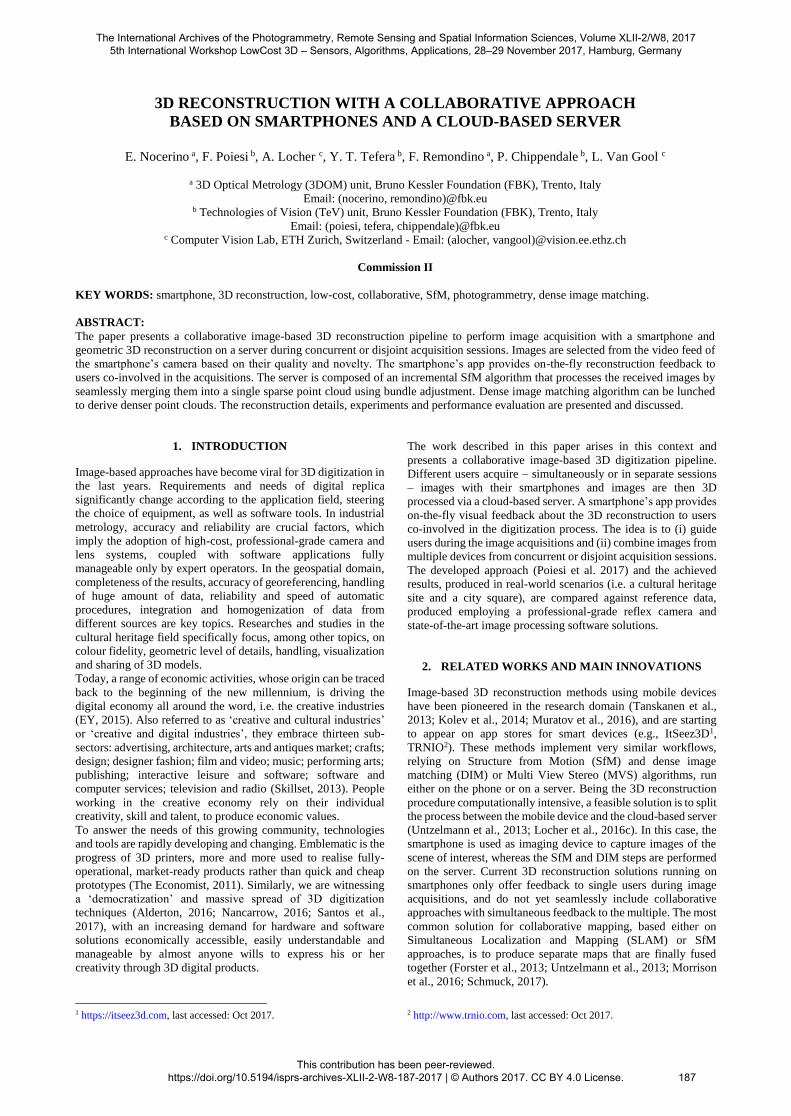
Figure 2: Example of on-the-fly visual feedback inside the smartphone’s app (left) during a collaborative digitization process
(here two users involved) or on the web browser (right).
3.5 3D reconstruction preview and visualisation
All users involved in a collaborative acquisition can visualize
their (simultaneous or joint) 3D reconstruction progresses via a
dedicated preview window in the smartphone’s app as well as
interact with the reconstruction session via a web page.
The preview model in the app shows to the user, while he/she is
acquiring images, the sparse point cloud with image positions
from all concurrent users (Fig. 2). The preview window runs on
a separate thread that periodically sends requests to the server to
check and, in case, display the updated scene reconstruction.
When the user terminates the acquisition and all images are
uploaded, the 3D reconstruction process is completed on the
server.
In a web browser, users can visualize the oriented images and the
sparse point cloud, download the estimated camera parameters
and access intermediate reconstructions.
4. EXPERIMENTS AND VALIDATION
The following section reports three experiments, performed in
real case scenarios, to showcase the capabilities of the proposed
pipeline. The collected datasets (4.1 – Table 1) and reference data
(4.2) are described, and the collaborative reconstruction results
are shown together with a quality assessment (4.3). All
experiments, acquired with different smartphones, were
afterwards processed with 20 cores on an Intel Xeon 2.30GHz
computer with 128 GB of RAM.
4.1 Datasets
The experiments entail the acquisition of video streams collected
using six different off-the-shelf Android smartphones in three
different locations (Table 1). To the authors knowledge, currently
there are no datasets that involve multiple and different
smartphones recording buildings or objects from different
viewpoints. For this reason, our datasets are available for
research purposes at the url http://tev.fbk.eu/collaborative3D.
Seq. Device
model
Resolution
(px)
No.
selected
frames
Device
orientation S
ara
nta
Ko
lon
es
1
Huawei P9
1920x1080 152 L/P
2 1920x1080 154 L/P
3 1920x1080 210 L/P
4
OnePlus One
1920x1080 117 P
5 1920x1080 105 P
6 1920x1080 59 P
7 1920x1080 44 P
8
Samsung S6 3840x20160
84 L
9 54 L
10 56 P
Pia
zza
Du
om
o
1 LG Nexus 5X 1920x1080 64 L/P
2 Samsung
Galaxy Alpha 640x480 91 L/P
3 SonyZ5 1920x1080 74 L
Ca
ffe
Itali
a 1 LG Nexus 5X 1920x1080 175 L/P
2 Samsung
Galaxy Alpha 640x480 218 L/P
3 SonyZ5 1920x1080 107 L/P
Table 1. Main characteristics of the employed datasets. L stands for landscape and P for portrait.
The first dataset (Saranta Kolones) features the ‘Saranta
Kolones’ monument within the Pafos archaeological area in
Cyprus. The site is ca 16x16x5m. Ten videos (at 30Hz) were
recorded by three different smartphones in different orientations
(landscape and portrait). Due to network connection limitations
on the Saranta Kolones’s site, the dataset was recorded using the
video mode of the smartphones and post-processed later by the
image selection algorithm (Section 3.2). A collaborative
acquisition approach was simulated by stirring in and
transmitting to the cloud-based server the extracted frames from
the different devices.
The International Archives of the Photogrammetry, Remote Sensing and Spatial Information Sciences, Volume XLII-2/W8, 2017 5th International Workshop LowCost 3D – Sensors, Algorithms, Applications, 28–29 November 2017, Hamburg, Germany
This contribution has been peer-reviewed. https://doi.org/10.5194/isprs-archives-XLII-2-W8-187-2017 | © Authors 2017. CC BY 4.0 License.
189
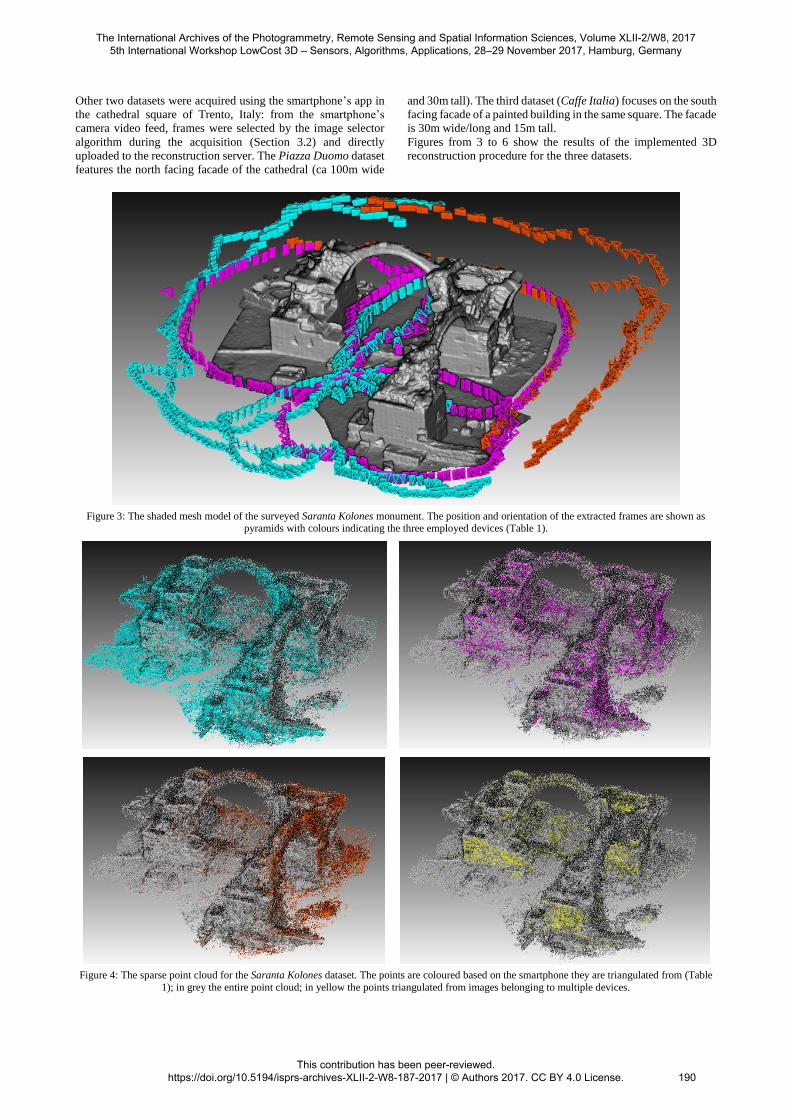
Other two datasets were acquired using the smartphone’s app in
the cathedral square of Trento, Italy: from the smartphone’s
camera video feed, frames were selected by the image selector
algorithm during the acquisition (Section 3.2) and directly
uploaded to the reconstruction server. The Piazza Duomo dataset
features the north facing facade of the cathedral (ca 100m wide
and 30m tall). The third dataset (Caffe Italia) focuses on the south
facing facade of a painted building in the same square. The facade
is 30m wide/long and 15m tall.
Figures from 3 to 6 show the results of the implemented 3D
reconstruction procedure for the three datasets.
Figure 3: The shaded mesh model of the surveyed Saranta Kolones monument. The position and orientation of the extracted frames are shown as pyramids with colours indicating the three employed devices (Table 1).
Figure 4: The sparse point cloud for the Saranta Kolones dataset. The points are coloured based on the smartphone they are triangulated from (Table
1); in grey the entire point cloud; in yellow the points triangulated from images belonging to multiple devices.
The International Archives of the Photogrammetry, Remote Sensing and Spatial Information Sciences, Volume XLII-2/W8, 2017 5th International Workshop LowCost 3D – Sensors, Algorithms, Applications, 28–29 November 2017, Hamburg, Germany
This contribution has been peer-reviewed. https://doi.org/10.5194/isprs-archives-XLII-2-W8-187-2017 | © Authors 2017. CC BY 4.0 License.
190
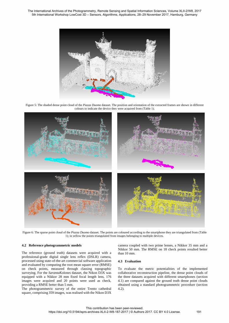
Figure 5: The shaded dense point cloud of the Piazza Duomo dataset. The position and orientation of the extracted frames are shown in different
colours to indicate the device they were acquired from (Table 1).
Figure 6: The sparse point cloud of the Piazza Duomo dataset. The points are coloured according to the smartphone they are triangulated from (Table 1); in yellow the points triangulated from images belonging to multiple devices.
4.2 Reference photogrammetric models
The reference (ground truth) datasets were acquired with a
professional-grade digital single lens reflex (DSLR) camera,
processed using state-of-the-art commercial software application
and evaluated by computing the root mean square error (RMSE)
on check points, measured through classing topographic
surveying. For the SarantaKolones dataset, the Nikon D3X was
equipped with a Nikkor 28 mm fixed focal length lens, 176
images were acquired and 20 points were used as check,
providing a RMSE better than 5 mm.
The photogrammetric survey of the entire Trento cathedral
square, comprising 359 images, was realised with the Nikon D3X
camera coupled with two prime lenses, a Nikkor 35 mm and a
Nikkor 50 mm. The RMSE on 18 check points resulted better
than 10 mm.
4.3 Evaluation
To evaluate the metric potentialities of the implemented
collaborative reconstruction pipeline, the dense point clouds of
the three datasets acquired with different smartphones (section
4.1) are compared against the ground truth dense point clouds
obtained using a standard photogrammetric procedure (section
4.2).
The International Archives of the Photogrammetry, Remote Sensing and Spatial Information Sciences, Volume XLII-2/W8, 2017 5th International Workshop LowCost 3D – Sensors, Algorithms, Applications, 28–29 November 2017, Hamburg, Germany
This contribution has been peer-reviewed. https://doi.org/10.5194/isprs-archives-XLII-2-W8-187-2017 | © Authors 2017. CC BY 4.0 License.
191
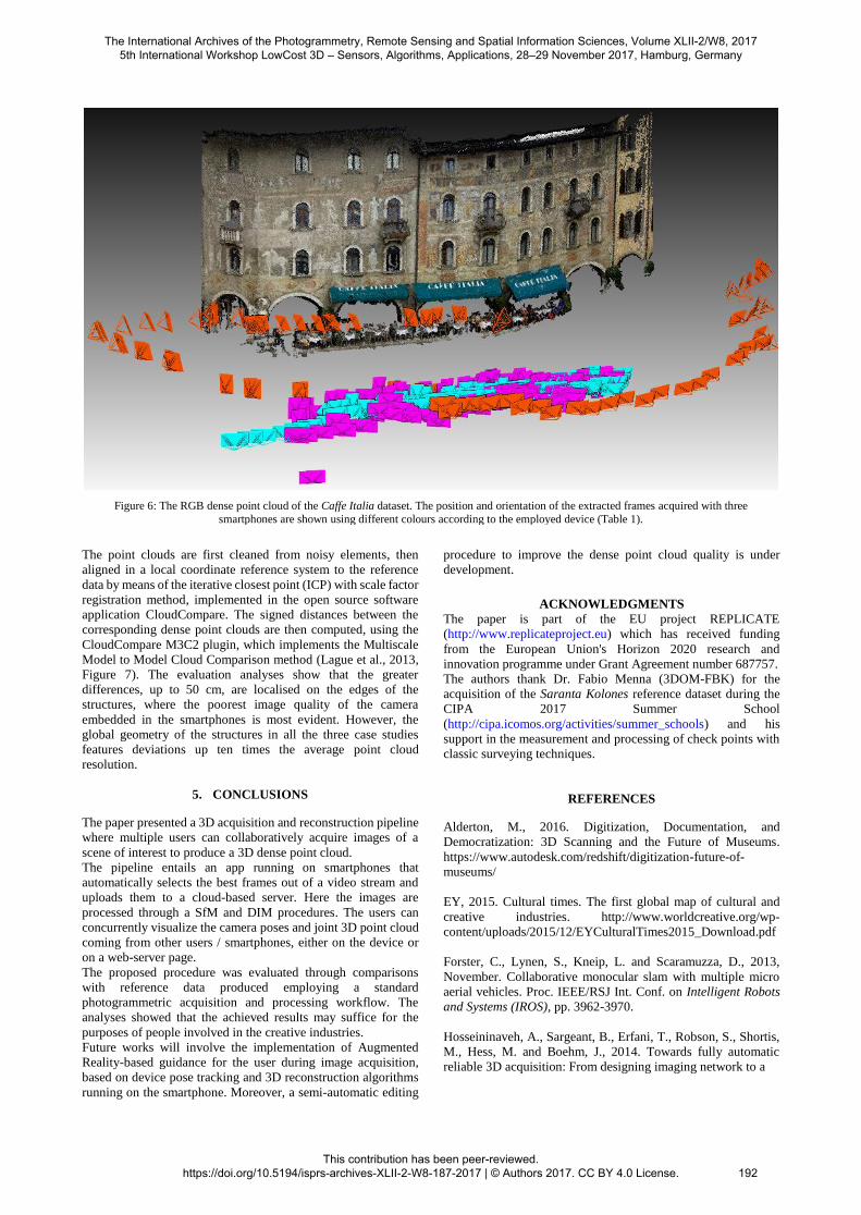
Figure 6: The RGB dense point cloud of the Caffe Italia dataset. The position and orientation of the extracted frames acquired with three
smartphones are shown using different colours according to the employed device (Table 1).
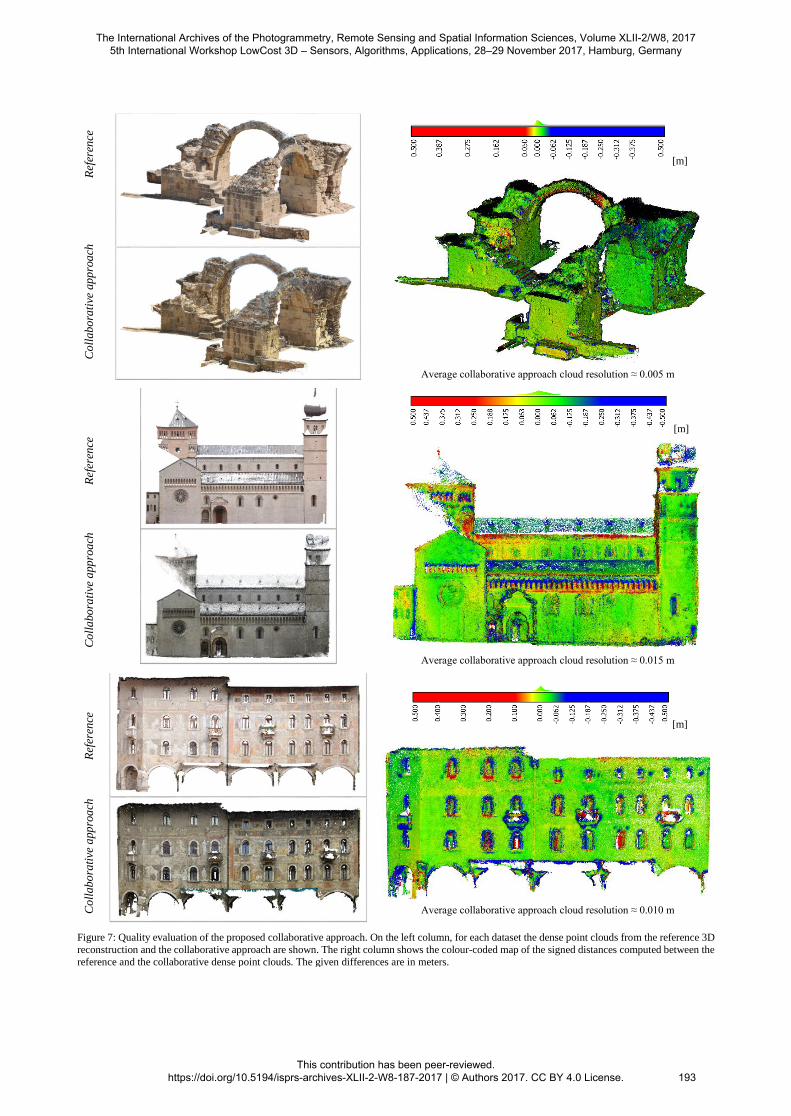
The point clouds are first cleaned from noisy elements, then
aligned in a local coordinate reference system to the reference
data by means of the iterative closest point (ICP) with scale factor
registration method, implemented in the open source software
application CloudCompare. The signed distances between the
corresponding dense point clouds are then computed, using the
CloudCompare M3C2 plugin, which implements the Multiscale
Model to Model Cloud Comparison method (Lague et al., 2013,
Figure 7). The evaluation analyses show that the greater
differences, up to 50 cm, are localised on the edges of the
structures, where the poorest image quality of the camera
embedded in the smartphones is most evident. However, the
global geometry of the structures in all the three case studies
features deviations up ten times the average point cloud
resolution.
5. CONCLUSIONS
The paper presented a 3D acquisition and reconstruction pipeline
where multiple users can collaboratively acquire images of a
scene of interest to produce a 3D dense point cloud.
The pipeline entails an app running on smartphones that
automatically selects the best frames out of a video stream and
uploads them to a cloud-based server. Here the images are
processed through a SfM and DIM procedures. The users can
concurrently visualize the camera poses and joint 3D point cloud
coming from other users / smartphones, either on the device or
on a web-server page.
The proposed procedure was evaluated through comparisons
with reference data produced employing a standard
photogrammetric acquisition and processing workflow. The
analyses showed that the achieved results may suffice for the
purposes of people involved in the creative industries.
Future works will involve the implementation of Augmented
Reality-based guidance for the user during image acquisition,
based on device pose tracking and 3D reconstruction algorithms
running on the smartphone. Moreover, a semi-automatic editing
procedure to improve the dense point cloud quality is under
development.
ACKNOWLEDGMENTS
The paper is part of the EU project REPLICATE
(http://www.replicateproject.eu) which has received funding
from the European Union's Horizon 2020 research and
innovation programme under Grant Agreement number 687757.
The authors thank Dr. Fabio Menna (3DOM-FBK) for the
acquisition of the Saranta Kolones reference dataset during the
CIPA 2017 Summer School
(http://cipa.icomos.org/activities/summer_schools) and his
support in the measurement and processing of check points with
classic surveying techniques.
REFERENCES
Alderton, M., 2016. Digitization, Documentation, and
Democratization: 3D Scanning and the Future of Museums.
https://www.autodesk.com/redshift/digitization-future-of-
museums/
EY, 2015. Cultural times. The first global map of cultural and
creative industries. http://www.worldcreative.org/wp-
content/uploads/2015/12/EYCulturalTimes2015_Download.pdf
Forster, C., Lynen, S., Kneip, L. and Scaramuzza, D., 2013,
November. Collaborative monocular slam with multiple micro
aerial vehicles. Proc. IEEE/RSJ Int. Conf. on Intelligent Robots
and Systems (IROS), pp. 3962-3970.
Hosseininaveh, A., Sargeant, B., Erfani, T., Robson, S., Shortis,
M., Hess, M. and Boehm, J., 2014. Towards fully automatic
reliable 3D acquisition: From designing imaging network to a
The International Archives of the Photogrammetry, Remote Sensing and Spatial Information Sciences, Volume XLII-2/W8, 2017 5th International Workshop LowCost 3D – Sensors, Algorithms, Applications, 28–29 November 2017, Hamburg, Germany
This contribution has been peer-reviewed. https://doi.org/10.5194/isprs-archives-XLII-2-W8-187-2017 | © Authors 2017. CC BY 4.0 License.
192
C
oll
ab
ora
tive
ap
pro
ach
Ref
eren
ce
[m]
Average collaborative approach cloud resolution ≈ 0.005 m
C
oll
abo
rati
ve a
pp
roa
ch
R
efer
ence
[m]
Average collaborative approach cloud resolution ≈ 0.015 m
C
oll
ab
ora
tive
app
roa
ch
Ref
eren
ce
[m]
Average collaborative approach cloud resolution ≈ 0.010 m
Figure 7: Quality evaluation of the proposed collaborative approach. On the left column, for each dataset the dense point clouds from the reference 3D
reconstruction and the collaborative approach are shown. The right column shows the colour-coded map of the signed distances computed between the
reference and the collaborative dense point clouds. The given differences are in meters.
The International Archives of the Photogrammetry, Remote Sensing and Spatial Information Sciences, Volume XLII-2/W8, 2017 5th International Workshop LowCost 3D – Sensors, Algorithms, Applications, 28–29 November 2017, Hamburg, Germany
This contribution has been peer-reviewed. https://doi.org/10.5194/isprs-archives-XLII-2-W8-187-2017 | © Authors 2017. CC BY 4.0 License.
193
complete and accurate point cloud. Robotics and Autonomous
Systems, 62(8), pp.1197-1207.
Kolev, K., Tanskanen, P., Speciale, P. and Pollefeys, M., 2014.
Turning mobile phones into 3D scanners. Proc. IEEE CVPR, pp.
3946-3953.
Lague, D., Brodu, N. and Leroux, J., 2013. Accurate 3D
comparison of complex topography with terrestrial laser scanner:
Application to the Rangitikei canyon (NZ). ISPRS Journal of
Photogrammetry and Remote Sensing, 82, pp.10-26.
Locher, A., Perdoch, M., Van Gool, L., 2016a. Progressive
Prioritized Multi-view Stereo. Proc. IEEE CVPR, pp. 3244-3252.
Locher, A., Havlena, M., Van Gool, L., 2016b. Progressive 3D
Modeling All the Way. Proc. 3D Vision (3DV), pp. 11-18.
Locher, A., Perdoch, M., Riemenschneider, H. and Van Gool, L.,
2016c. Mobile phone and cloud—A dream team for 3D
reconstruction. Proc. IEEE Winter Conference on Applications of
Computer Vision (WACV), pp. 1-8.
Morrison, J.G., Gálvez-López, D. and Sibley, G., 2016.
MOARSLAM: Multiple operator augmented RSLAM. In
Distributed Autonomous Robotic Systems, pp. 119-132.
Nancarrow, J.H., 2016. Democratizing the Digital Collection:
New Players and New Pedagogies. Three-Dimensional Cultural
Heritage. Museum Worlds, 4(1), pp.63-77.
Nistér, D., 2004. An efficient solution to the five-point relative
pose problem. IEEE transactions on pattern analysis and
machine intelligence, 26(6), pp.756-770.
Nistér, D. and Stewenius, H., 2006. Scalable recognition with a
vocabulary tree. Proc. IEEE CVPR, pp. 2161-2168.
Nocerino, E., Lago, F., Morabito, D., Remondino, F., Porzi, L.,
Poiesi, F., Bulo, S.R., Chippendale, P., Locher, A., Havlena, M.
and Van Gool, L., 2017. A smartphone-based 3D pipeline for the
creative industry–the REPLICATE EU project. International
Archives of the Photogrammetry, Remote Sensing and Spatial
Information Sciences, pp.535-541.
Poiesi, F., Locher, A., Chippendale, P., Nocerino, E.,
Remondino, F. and Van Gool, L., 2017. Cloud-based
collaborative 3D reconstruction using smartphones. Proc. 14th
European Conference on Visual Media Production (CVMP
2017), 9 pages, https://doi.org/10.1145/3150165.3150166.
Rublee E., Rabaud, V., Konolige, K., Bradski, G., 2011. ORB:
an efficient alternative to SIFT or SURF. Proc. IEEE ICCV, pp.
2564-2571.
Santos, P., Ritz, M., Fuhrmann, C. and Fellner, D., 2017. 3D
mass digitization: a milestone for archaeological documentation.
In: Virtual Archaeology Review, 8(1).
Schmuck, P., 2017. Multi-UAV collaborative monocular SLAM.
In Robotics and Automation (ICRA), pp. 3863-3870.
Schonberger, J.L. and Frahm, J.M., 2016. Structure-from-motion
revisited. Proc. IEEE CVPR, pp. 4104-4113.
Sieberth, T., Wackrow, R., Chandler, J.H., 2016: Automatic
detection of blurred images in UAV image sets. Journal of
Archaeological Science, Vol. 122, pp. 1-16
Skillset, C., 2013. Classifying and measuring the creative
industries. Department for Culture Media & Sport.
Sweeney, C., Sattler, T., Hollerer, T., Turk, M. and Pollefeys, M.,
2015. Optimizing the viewing graph for structure-from-motion.
Proc. IEEE ICCV, pp. 801-809.
Tanskanen, P., Kolev, K., Meier, L., Camposeco, F., Saurer, O.
and Pollefeys, M., 2013. Live metric 3D reconstruction on
mobile phones. Proc. IEEE ICCV, pp. 65-72.
The Economist, 2011. 3D printing. The printed world.
http://www.economist.com/node/18114221
Untzelmann, O., Sattler, T., Middelberg, S. and Kobbelt, L.,
2013. A scalable collaborative online system for city
reconstruction. Proc. IEEE ICCV, pp. 644-651.
The International Archives of the Photogrammetry, Remote Sensing and Spatial Information Sciences, Volume XLII-2/W8, 2017 5th International Workshop LowCost 3D – Sensors, Algorithms, Applications, 28–29 November 2017, Hamburg, Germany
This contribution has been peer-reviewed. https://doi.org/10.5194/isprs-archives-XLII-2-W8-187-2017 | © Authors 2017. CC BY 4.0 License.
194