Embed Size (px)
Citation preview

3D Documentation of
Condominium in Switzerland
Today and a draft for the future /
May, 30th 2017
Helena Åström Boss
Federal Office of Topography swisstopo
Cadastral surveying and PLR-cadastre
Presented at th
e FIG W
orking Week 2017,
May 29 - June 2, 2
017 in Helsinki, F
inland

FIG Working Week 2017, Helsinki
May, 30th 2017
Federal Office of Topography swisstopo
Cadastral surveying and PLR-cadastre
Agenda
• Context in Switzerland
• Documentation of condominiums today
• Two kinds of digital documentation
• Ideas for the documentation of condominiums in
future
2

FIG Working Week 2017, Helsinki
May, 30th 2017
Federal Office of Topography swisstopo
Cadastral surveying and PLR-cadastre
The Swiss Cadastral System
3
Definition of condominium:
a kind of co-property, a value share with the exclusive
right to use a part of the house

FIG Working Week 2017, Helsinki
May, 30th 2017
Federal Office of Topography swisstopo
Cadastral surveying and PLR-cadastre
Switzerland, a Confederation of 26 Cantons
Legal and organisational consequences for
Cadastral surveying:
• a common task between confederation and cantons
• regulations mostly on federal, some on cantonal level
• strategy is developed by confederation (in cooperation
with cantons)
• supervision by confederation, execution led by cantons
Land registry:
• a task of the 26 cantons
• general rules in Civil Code and Land registry ordinances
• the cantons themselves regulate the execution
4

FIG Working Week 2017, Helsinki
May, 30th 2017
Federal Office of Topography swisstopo
Cadastral surveying and PLR-cadastre
Documentation of Condominiums
• On federal level only very general and no technical
regulations
• Unknown situation in the 26 cantons, no statistic
Therefore, a first survey was conducted in 2016 by
the working group with the goal to get:
• an overview of existing cantonal regulations
• information on how the documentation is made
today in practice
• statistical data on a national scale
• knowledge of problems or of possible needs for
improvement
5

FIG Working Week 2017, Helsinki
May, 30th 2017
Federal Office of Topography swisstopo
Cadastral surveying and PLR-cadastre
Existing Cantonal Regulations (2016)
Do the cantonal laws or directives stipulate how the
documentation of condominiums has to be done in the
allocation plan and in other documents?
6
SG
ZG
ZH
LU
TI
VS GE
VD
TG
GL SZ
UR
NW
OW
AG
GR
B L
BS
JU
SH
AR
NE
SO
FR
AI
BE
No: 19
Yes: 5
(thereof in revision: 1)
Yes, digital, raster: 1
Yes, digital, vector:1
Geneva
Basel
Lausanne
Bern
Zürich

FIG Working Week 2017, Helsinki
May, 30th 2017
Federal Office of Topography swisstopo
Cadastral surveying and PLR-cadastre
The Documentation of Condominiums Today (normal case)
A representative example
(canton Basel Landscape):
A paper-based CAD-map
per floor, with additional
cross sections and side
views containing height
information.
Exclusive use
Common use
7

FIG Working Week 2017, Helsinki
May, 30th 2017
Federal Office of Topography swisstopo
Cadastral surveying and PLR-cadastre
Comparison of the Digital Solutions in the Cantons of Geneva and Neuchâtel
Canton of Geneva Canton of Neuchâtel
Vector data Raster data
Specified data model (2D + H) Pdf/A format
Mandatory for all new units Mandatory for all new units
Current no digitization of existing documentations
Digitization of all existing documentations in progress
Buildings and condominium units part of the cantonal GIS
Buildings and condominium units part of the cantonal GIS
Data management indepen-dent of cadastral surveying
Part of the cadastral surveying data model (cantonal extension)
No direct link to the land register
Directly linked to the land register
8
<>
=
=
<>
<>
<>
<>

FIG Working Week 2017, Helsinki
May, 30th 2017
Federal Office of Topography swisstopo
Cadastral surveying and PLR-cadastre
Workflow in the Cadastral Surveying Office in Geneva Today (1)
• Accept the architectural data and import into a CAD
• Georeferencing
• Manual generalization with simultaneous control
• Assembly of units
• Transfer to a GIS
• Assembly of sub units (geometry and attributes)
• Calculation of value shares
• Establishment of the allocation documentation (on
paper) containing allocation plan, overviews and
detailed tables, additional plans for servitudes, …
• Controls (incl. a as built survey)
9
CAD
GIS

FIG Working Week 2017, Helsinki
May, 30th 2017
Federal Office of Topography swisstopo
Cadastral surveying and PLR-cadastre
Workflow in the Cadastral Surveying Office in Geneva Today (2)
10
Source: Presentation «Le cahier de PPE numérique 2D/3D à Genève», Bizouard, KKVA 28.04.16

FIG Working Week 2017, Helsinki
May, 30th 2017
Federal Office of Topography swisstopo
Cadastral surveying and PLR-cadastre
On-going Adjustments in Geneva
Next steps:
• Adapt the workflow for integration of BIM
• Later (semi-)automated interface BIM to GIS
Obstacles:
• There are no federal technical regulations and no
data model for geometrical documentation of
condominium
• Missing national standard or federal regulation on
BIM for data exchange with federal or cantonal
administration
11

FIG Working Week 2017, Helsinki
May, 30th 2017
Federal Office of Topography swisstopo
Cadastral surveying and PLR-cadastre
Arguments for New Regulations on Federal Level
• 4.5 million parcels (in all 26 cantons)
• 1.1 million condominium units (in 23 cantons),
at least 1.2 million in all of Switzerland
• Total amount of mortgages almost 1,000 billion CHF
(approx. 910 billion EUR)
No unique digital documentation of condominiums,
a big part of mortgages.
Other e-government processes: construction permit,
urban planning
12

FIG Working Week 2017, Helsinki
May, 30th 2017
Federal Office of Topography swisstopo
Cadastral surveying and PLR-cadastre
Approaches for New Regulations on Federal Level
Proposed adjustments for the digital 3D documentation
of condominiums:
• to establish a new data model and test it;
• to propose necessary adjustments to the legal and
technical regulations;
• in particular, to examine a possible improvement of
the legal meaning of the allocation plan.
• Idea: The allocation plan can be part of cadastral
surveying, and not only a document of land registry.
13
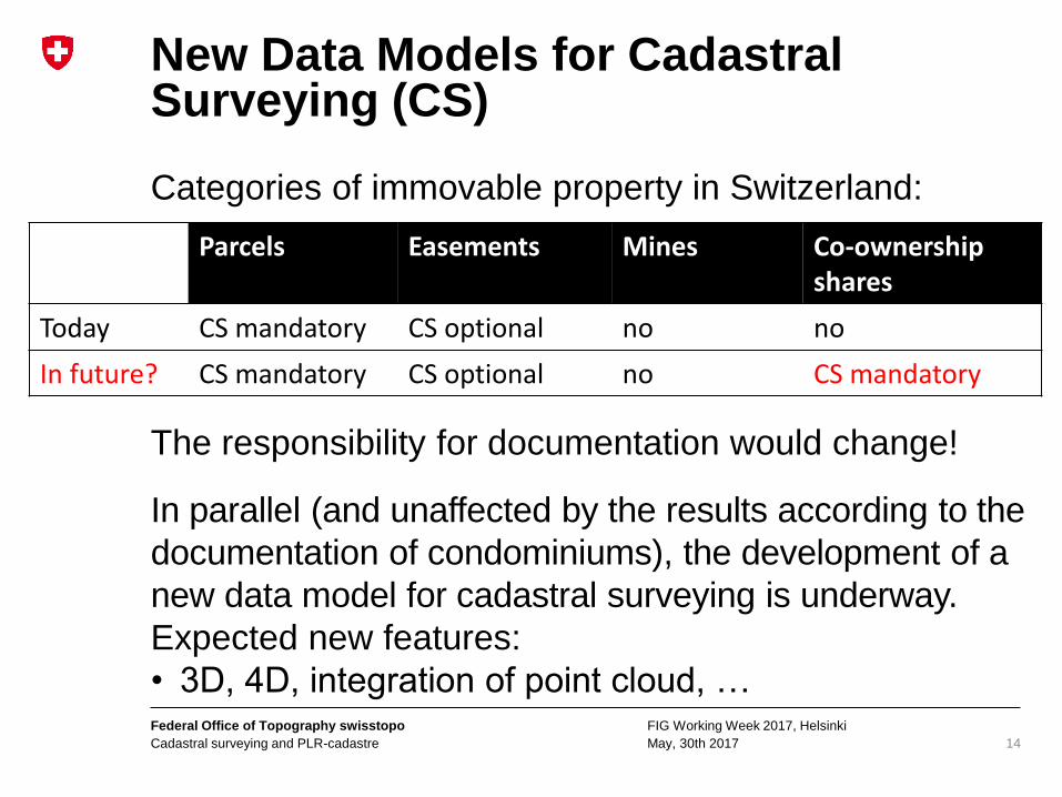
FIG Working Week 2017, Helsinki
May, 30th 2017
Federal Office of Topography swisstopo
Cadastral surveying and PLR-cadastre
New Data Models for Cadastral Surveying (CS)
Categories of immovable property in Switzerland:
The responsibility for documentation would change!
In parallel (and unaffected by the results according to the
documentation of condominiums), the development of a
new data model for cadastral surveying is underway.
Expected new features:
• 3D, 4D, integration of point cloud, …
14
Parcels Easements Mines Co-ownership shares
Today CS mandatory CS optional no no
In future? CS mandatory CS optional no CS mandatory

FIG Working Week 2017, Helsinki
May, 30th 2017
Federal Office of Topography swisstopo
Cadastral surveying and PLR-cadastre
Thank you for your attention!
Helena Åström Boss, project manager
3D property cadastre
15