Embed Size (px)
Citation preview
Artemis Resources Limited ABN: 80 107 051 749
Telephone: +61 2 9078 7670 | Facsimile: +61 2 9078 7661 | Email: [email protected]
Level 9, 50 Margaret Street, SYDNEY NSW 2000 | PO Box R933 Royal Exchange, NSW 1225 Australia www.artemisresources.com.au
1
ASX Announcement 12 November 2013
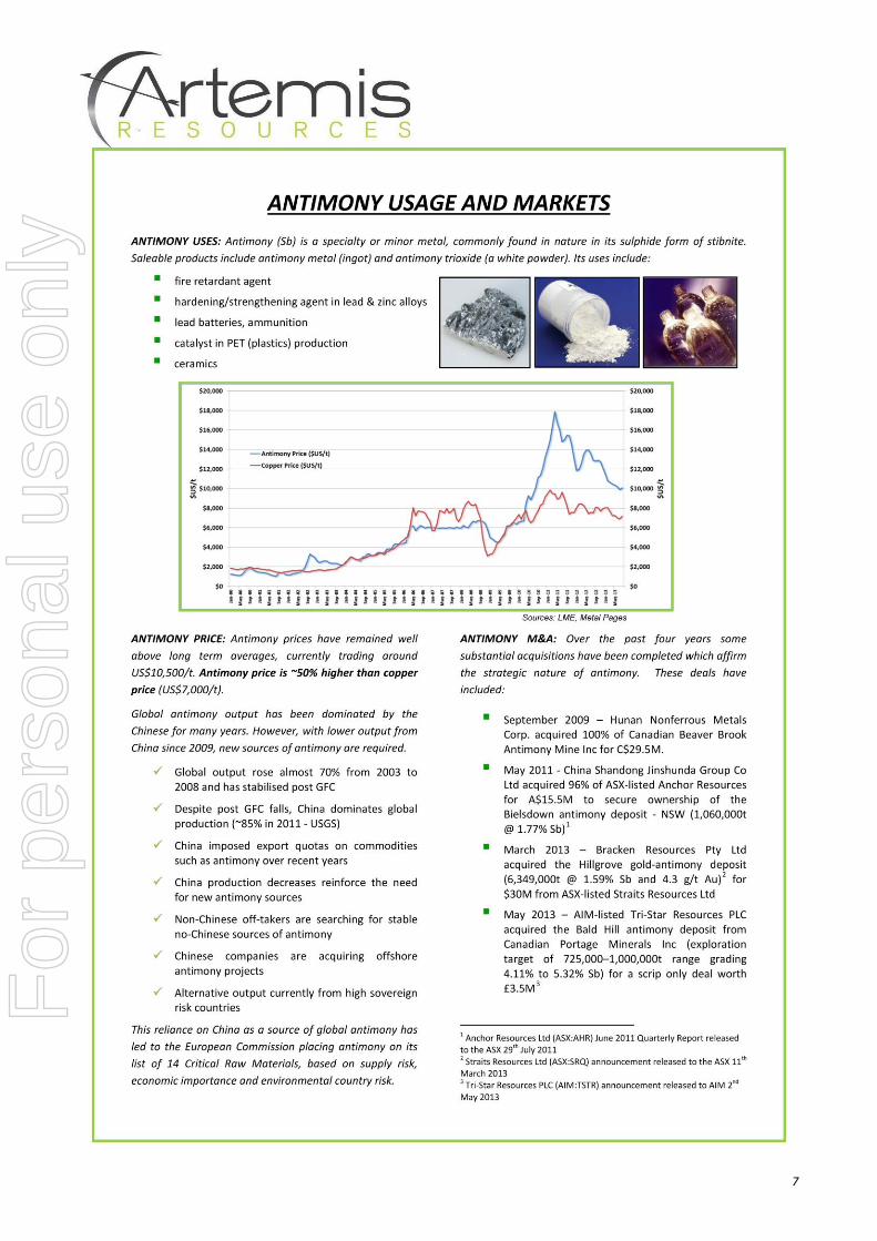
35.7% Sb - HIGHEST ANTIMONY RESULT TO DATE AT EASTERN HILLS New Dugite Zone grades overshadow Taipan Zone
EASTERN HILLS ANTIMONY-LEAD (Sb - Pb) DEPOSIT
New zone at Eastern Hills reveals highest antimony grade to date
Dugite Zone rock chip sample returns 35.7% Sb, 29.0% Pb, 1,335g/t Ag & 0.56g/t Au
Significant gold mineralisation also identified – up to 3.36g/t Au in Dugite Zone rock chip sample
Historic rock chip results up to 33.0% Sb, 36.0% Pb, 1,500g/t Ag & 6.80g/t Au also on Dugite Zone
Reinforces potential of new zones to add to Taipan Zone metal inventory
Follow-up field campaign in November to close off 2013 field season
JORC code compliant resource estimation of Taipan Zone mineralisation is underway
Artemis Resources Limited (ASX: ARV) is pleased to announce that high grade assay results have been received from follow-up geological mapping and sampling of antimony-lead mineralisation zones identified in close proximity to the Taipan Zone at Eastern Hills (Figure 1), located in the Ashburton region of Western Australia (Figure 4). While the Taipan Zone was the focus of Artemis’ recent drilling programme and current JORC resource study, the Company announced in September
1 that it had identified three additional zones of similar style mineralisation that appear to be
part of a more widespread mineralised system – the Dugite, Gwardar and Tiger Zones. The latest rock chip sampling results from the Dugite Zone, located just north of the Taipan Zone, have returned the highest antimony grade seen to date at the Eastern Hills Project of 35.7% Sb. The same sample, collected from the eastern portion of the Dugite Zone (Figures 1 & 2), also included extremely high grades of 29.0% Pb, 1,335g/t silver (Ag) & 0.56g/t gold (Au). Further significant results from the Company’s October rock chip sampling of the new zones included:
5.4% Sb, 9.2% Pb, 277g/t Ag & 1.53g/t Au (Dugite Zone)
1.1% Sb, 3.9% Pb, 44g/t Ag & 3.36g/t Au (Dugite Zone)
3.8% Sb, 11.7% Pb, 50g/t Ag & 0.24g/t Au (Tiger Zone) These results elevate the Dugite Zone to become a key focus in the Company’s quest for additional resources to add to the mineralisation recently drilled at the Taipan Zone. This is reinforced by Artemis’ recent re-evaluation of previously unseen historical data which revealed rock chip sampling results of up to 33.0% Sb, 36.0% Pb, 1,500g/t Ag & 6.80g/t Au in the vicinity of the Dugite Zone high grade results described above (Figure 2). Artemis will undertake another detailed mapping and sampling campaign of the Dugite, Gwardar and Tiger Zones over the coming weeks, before the end of the field season. Artemis General Manager-Exploration, Trevor Woolfe, commented: “Our exceptionally high grade rock chip results from the Dugite Zone that correlate with equally exceptional historical sampling results highlight the new zone’s antimony-lead-silver-gold potential in addition to that already outlined at the Taipan Zone. The high grades at Dugite are significantly higher than any of the surface sampling results recorded on the Taipan Zone.”
1 As per ASX announcement dated 26th September 2013 “New Antimony Zones Identified at Eastern Hills”
For
per
sona
l use
onl
y
2
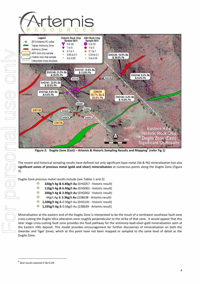
The exceptional Artemis results described above are located at the eastern end of the Dugite Zone (Figure 1). Other significant results from the recent Artemis surface sampling can be seen in Table 1, with significant historic rock chip results recorded in Table 2. A more detailed view of the distribution of the high grade samples to the east of the Dugite Zone can be seen in Figure 2.
Figure 1: Eastern Hills - Latest Sampling of New Zones Adjacent to Taipan Zone (recently drilled)
EASTERN HILLS Sb-Pb – A MULTIPLE VEIN SYSTEM CONFIRMED In January 2013, Artemis announced an exploration target
2 at Eastern Hills. This target was based on antimony-lead
mineralisation identified by historical exploration on a singular massive sulphide vein (now known as the Taipan Zone) over a strike length of at least 600m. Identification of three new zones (Dugite, Gwardar and Tiger), as well as extensions to the Taipan Zone, through mapping and sampling in September
1, increased the potentially mineralised
combined strike length of all four zones by 350% to 2.8km. Quartz-sericite alteration and silicification along fault structures identified at Dugite, Gwardar and Tiger corresponds with similar mineralised alteration on the Taipan Zone and indicates that the Eastern Hills system is not a lone vein, but a multiple vein system. The latest round of rock chip sampling, consisting of 15 samples, was undertaken during breaks in the recent Taipan Zone drilling programme. Sampling was focussed on the Dugite and Tiger Zones in response to positive results received from our initial mapping programme in September where results of up to 2.9% Sb (Dugite Zone) and 5.0% Sb (Tiger Zone) were obtained
1.
2 Exploration target reported in ASX Announcements dated 16 and 18 January 2013
For
per
sona
l use
onl
y
3
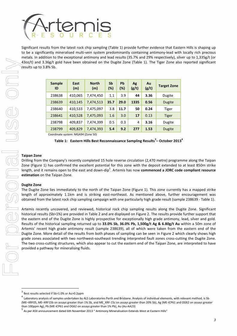
Significant results from the latest rock chip sampling (Table 1) provide further evidence that Eastern Hills is shaping up to be a significantly mineralised multi-vein system predominantly containing antimony-lead with locally rich precious metals. In addition to the exceptional antimony and lead results (35.7% and 29% respectively), silver up to 1,335g/t (or 43oz/t) and 3.36g/t gold have been obtained on the Dugite Zone (Table 1). The Tiger Zone also reported significant results up to 3.8% Sb.
Sample ID
East (m)
North (m)
Sb (%)
Pb (%)
Ag (g/t)
Au (g/t)
Target Zone
238638 410,065 7,474,450 1.1 3.9 44 3.36 Dugite
238639 410,145 7,474,513 35.7 29.0 1335 0.56 Dugite
238640 410,533 7,475,097 3.8 11.7 50 0.24 Tiger
238641 410,528 7,475,093 1.6 3.0 17 0.13 Tiger
238798 409,837 7,474,399 0.5 0.3 4 3.16 Dugite
238799 409,829 7,474,393 5.4 9.2 277 1.53 Dugite
Coordinate system: MGA94 (Zone 50) Table 1: Eastern Hills Best Reconnaissance Sampling Results
3– October 2013
4
Taipan Zone Drilling from the Company’s recently completed 15 hole reverse circulation (2,470 metre) programme along the Taipan Zone (Figure 1) has confirmed the excellent potential for this zone with the deposit extended to at least 850m strike length, and it remains open to the east and down-dip
5. Artemis has now commenced a JORC code compliant resource
estimation on the Taipan Zone. Dugite Zone The Dugite Zone lies immediately to the north of the Taipan Zone (Figure 1). This zone currently has a mapped strike length of approximately 1.1km and is striking east-northeast. As mentioned above, further encouragement was obtained from the latest rock chip sampling campaign with one particularly high grade result (sample 238639 - Table 1). Artemis recently uncovered, and reviewed, historical rock chip sampling results along the Dugite Zone. Significant historical results (Sb>1%) are provided in Table 2 and are displayed on Figure 2. The results provide further support that the eastern end of the Dugite Zone is highly prospective for exceptionally high grade antimony, lead, silver and gold. Results of the historical sampling returned up to 33.0% Sb, 36.0% Pb, 1,500g/t Ag & 6.80g/t Au within a 50m zone of Artemis’ recent high grade antimony result (sample 238639), all of which were taken from the eastern end of the Dugite Zone. More detail of the results from both phases of sampling can be seen in Figure 2 which clearly shows high grade zones associated with two northwest-southeast trending interpreted fault zones cross-cutting the Dugite Zone. The two cross-cutting structures, which also appear to cut the eastern end of the Taipan Zone, are interpreted to have provided a pathway for mineralising fluids.
3 Best results selected if Sb>1.0% or Au>0.2ppm
4 Laboratory analysis of samples undertaken by ALS Laboratories Perth and Brisbane. Analysis of individual elements, with relevant method, is Sb
(ME–XRF05, ME–XRF15b on assays greater than 1% Sb, and ME_XRF-15c on assays greater than 20% Sb), Ag (ME-ICP61 and OG62 on assays greater than 100ppm Ag), Pb (ME-ICP61 and OG62 on assays greater than 1% Pb), Au (Au-AA23) 5 As per ASX announcement dated 6th November 2013 “ Antimony Mineralisation Extends West at Eastern Hills”
For
per
sona
l use
onl
y
4
Figure 2: Dugite Zone (East) – Artemis & Historic Sampling Results and Mapping
6 (refer Fig 1)
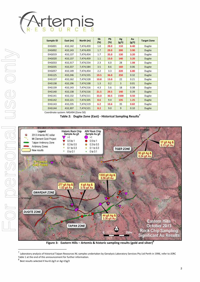
The recent and historical sampling results have defined not only significant base metal (Sb & Pb) mineralisation but also significant zones of precious metal (gold and silver) mineralisation at numerous points along the Dugite Zone (Figure 3). Dugite Zone precious metal results include (see Tables 1 and 2):
220g/t Ag & 6.80g/t Au (EHG057 - historic result)
110g/t Ag & 6.40g/t Au (EHG001 - historic result)
200g/t Ag & 3.90g/t Au (EHG002 - historic result)
44g/t Ag & 3.36g/t Au (238638 - Artemis result)
1,500g/t Ag & 0.50g/t Au (EHG141 - historic result)
1,335g/t Ag & 0.56g/t Au (238639 - Artemis result) Mineralisation at the eastern end of the Dugite Zone is interpreted to be the result of a northwest-southeast fault zone cross-cutting the Dugite silica alteration zone roughly perpendicular to the strike of that zone. It would appear that this later stage cross-cutting fault zone provides the fluid pathway for the antimony-lead-silver-gold mineralisation seen at the Eastern Hills deposit. This model provides encouragement for further discoveries of mineralisation on both the Gwardar and Tiger Zones, which at this point have not been mapped or sampled to the same level of detail as the Dugite Zone.
6 Best results selected if Sb>5.0%
For
per
sona
l use
onl
y
5
Sample ID East (m) North (m) Sb (%)
Pb (%)
Ag (g/t)
Au (g/t)
Target Zone
EHG001 410,142 7,474,459 1.0 28.0 110 6.40 Dugite
EHG002 410,143 7,474,459 1.7 29.0 200 3.90 Dugite
EHG019 410,137 7,474,454 1.7 35.0 130 3.20 Dugite
EHG020 410,137 7,474,459 1.1 13.0 140 3.20 Dugite
EHG033 410,317 7,474,554 2.3 6.0 28 1.08 Dugite
EHG035 410,337 7,474,584 3.5 8.6 160 0.06 Dugite
EHG057 410,149 7,474,454 2.2 3.3 220 6.80 Dugite
EHG125 410,246 7,474,555 19.5 36.0 250 0.32 Dugite
EHG137 410,162 7,474,528 10.8 13.0 22 0.21 Dugite
EHG138 410,196 7,474,538 1.3 0.2 3 0.01 Dugite
EHG139 410,143 7,474,516 4.3 5.6 18 0.38 Dugite
EHG140 410,138 7,474,516 21.5 29.5 140 0.39 Dugite
EHG141 410,132 7,474,511 33.0 30.5 1500 0.50 Dugite
EHG142 410,121 7,474,505 8.6 9.4 135 1.25 Dugite
EHG143 410,235 7,474,519 6.2 10.6 35 0.82 Dugite
EHG144 410,307 7,474,521 8.2 9.0 9 0.10 Dugite
Coordinate system: MGA94 (Zone 50)
Table 2: Dugite Zone (East) - Historical Sampling Results7
Figure 3: Eastern Hills – Artemis & historic sampling results (gold and silver)
8
7 Laboratory analysis of historical Taipan Resources NL samples undertaken by Genalysis Laboratory Services Pty Ltd Perth in 1996, refer to JORC
Table 1 at the end of this announcement for further information. 8 Best results selected if Au>0.2g/t or Ag>15g/t
For
per
sona
l use
onl
y
6
Tiger Zone The Tiger Zone is located 500 metres to the northeast of the Taipan Zone (Figure 1) and returned a high grade result of 5.0% Sb from the recent September 2013 sampling programme. Follow-up work during October detailed further encouraging mineralisation with 3.8% Sb and 1.6% Sb results obtained from this latest campaign (Table 1). The Tiger Zone has a northeast orientation which, although different from the more central alteration zones, still shows evidence of a pathway for mineralisation along the fault structure. The Tiger Zone, with only limited mapping and sampling by Artemis to date (8 samples), will be a focus for follow-up mapping and rock chip sampling this month.
Gwardar Zone The Gwardar Zone was recently identified
1 and lies to the north of the Dugite Zone (Figure 1) with an approximate
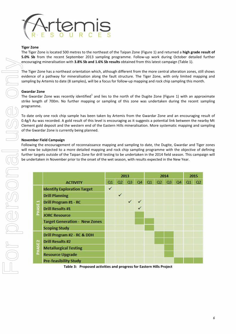
strike length of 700m. No further mapping or sampling of this zone was undertaken during the recent sampling programme. To date only one rock chip sample has been taken by Artemis from the Gwardar Zone and an encouraging result of 0.4g/t Au was recorded. A gold result of this level is encouraging as it suggests a potential link between the nearby Mt Clement gold deposit and the western end of the Eastern Hills mineralisation. More systematic mapping and sampling of the Gwardar Zone is currently being planned. November Field Campaign Following the encouragement of reconnaissance mapping and sampling to date, the Dugite, Gwardar and Tiger zones will now be subjected to a more detailed mapping and rock chip sampling programme with the objective of defining further targets outside of the Taipan Zone for drill testing to be undertaken in the 2014 field season. This campaign will be undertaken in November prior to the onset of the wet season, with results expected in the New Year.
Table 3: Proposed activities and progress for Eastern Hills ProjectFor
per
sona
l use
onl
y
7
For
per
sona
l use
onl
y
8
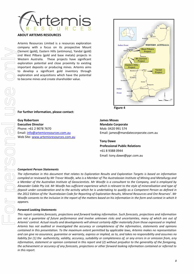
ABOUT ARTEMIS RESOURCES Artemis Resources Limited is a resources exploration company with a focus on its prospective Mount Clement (gold), Eastern Hills (antimony), Yandal (gold) and West Pilbara (gold and base metals) projects in Western Australia. These projects have significant exploration potential and close proximity to existing important deposits or producing mines. Artemis aims to develop a significant gold inventory through exploration and acquisitions which have the potential to become mines and create shareholder value.
Figure 4 For further information, please contact:
Guy Robertson James Moses Executive Director Mandate Corporate Phone: +61 2 9078 7670 Mob: 0420 991 574 Email: [email protected] Email: [email protected] Web Site: www.artemisresources.com.au Tony Dawe
Professional Public Relations
+61 8 9388 0944
Email: [email protected]
Competent Person Statements
The information in this document that relates to Exploration Results and Exploration Targets is based on information compiled or reviewed by Mr Trevor Woolfe, who is a Member of The Australasian Institute of Mining and Metallurgy and a Member of the Australian Institute of Geoscientists. Mr Woolfe is a consultant to the Company, and is employed by Alexander Cable Pty Ltd. Mr Woolfe has sufficient experience which is relevant to the style of mineralisation and type of deposit under consideration and to the activity which he is undertaking to qualify as a Competent Person as defined in the 2012 Edition of the ‘Australasian Code for Reporting of Exploration Results, Mineral Resources and Ore Reserves’. Mr Woolfe consents to the inclusion in the report of the matters based on his information in the form and context in which it appears. Forward Looking Statements
This report contains forecasts, projections and forward looking information. Such forecasts, projections and information are not a guarantee of future performance and involve unknown risks and uncertainties, many of which are out of Artemis’ control. Actual results and developments will almost certainly differ materially from those expressed or implied. Artemis has not audited or investigated the accuracy or completeness of the information, statements and opinions contained in this presentation. To the maximum extent permitted by applicable laws, Artemis makes no representation and can give no assurance, guarantee or warranty, express or implied, as to, and takes no responsibility and assumes no liability for (1) the authenticity, validity, accuracy, suitability or completeness of, or any errors in or omission from, any information, statement or opinion contained in this report and (2) without prejudice to the generality of the foregoing, the achievement or accuracy of any forecasts, projections or other forward looking information contained or referred to in this report.
For
per
sona
l use
onl
y
9
JORC Code, 2012 Edition – Table 1 report template
Section 1 Sampling Techniques and Data
(Criteria in this section apply to all succeeding sections.)
Criteria JORC Code explanation Commentary
Sampling techniques
Nature and quality of sampling (eg cut channels, random chips, or specific specialised industry standard measurement tools appropriate to the minerals under investigation, such as down hole gamma sondes, or handheld XRF instruments, etc). These examples should not be taken as limiting the broad meaning of sampling.
Include reference to measures taken to ensure sample representivity and the appropriate calibration of any measurement tools or systems used.
Aspects of the determination of mineralisation that are Material to the Public Report.
In cases where ‘industry standard’ work has been done this would be relatively simple (eg ‘reverse circulation drilling was used to obtain 1 m samples from which 3 kg was pulverised to produce a 30 g charge for fire assay’). In other cases more explanation may be required, such as where there is coarse gold that has inherent sampling problems. Unusual commodities or mineralisation types (eg submarine nodules) may warrant disclosure of detailed information.
A rock chip sampling technique testing specific
geological targets was used to obtain a 0.5-1.5kg
sample for submission to the laboratory for ICP
and XRF analysis.
No field duplicates or blanks were submitted for
analysis.
Drilling techniques
Drill type (eg core, reverse circulation, open-hole
hammer, rotary air blast, auger, Bangka, sonic,
etc) and details (eg core diameter, triple or
standard tube, depth of diamond tails, face-
sampling bit or other type, whether core is
oriented and if so, by what method, etc).
Not applicable
Drill sample recovery
Method of recording and assessing core and
chip sample recoveries and results assessed.
Measures taken to maximise sample recovery
and ensure representative nature of the
samples.
Whether a relationship exists between sample
recovery and grade and whether sample bias
may have occurred due to preferential loss/gain
of fine/coarse material.
Not applicable
Logging Whether core and chip samples have been
geologically and geotechnically logged to a level
of detail to support appropriate Mineral
Resource estimation, mining studies and
metallurgical studies.
Whether logging is qualitative or quantitative in
nature. Core (or costean, channel, etc)
photography.
The total length and percentage of the relevant
intersections logged.
All rock samples are geologically logged by the
geologist in the field.
It is not considered that these samples will be
used to support appropriate Mineral Resource
estimation, mining studies or metallurgical studies.
Logging is considered to be semi-quantitative
given the nature of the alteration of these surficial
rock chips and the inability to obtain detailed
geological information.
Sub-sampling techniques and sample
If core, whether cut or sawn and whether
quarter, half or all core taken.
If non-core, whether riffled, tube sampled, rotary
The random sampling of rock chips is considered
representative of the mineralisation contained in
the identified alteration zones (Taipan, Dugite,
For
per
sona
l use
onl
y
10
Criteria JORC Code explanation Commentary
preparation split, etc and whether sampled wet or dry.
For all sample types, the nature, quality and
appropriateness of the sample preparation
technique.
Quality control procedures adopted for all sub-
sampling stages to maximise representivity of
samples.
Measures taken to ensure that the sampling is
representative of the in situ material collected,
including for instance results for field
duplicate/second-half sampling.
Whether sample sizes are appropriate to the
grain size of the material being sampled.
Gwardar and Tiger Zones at the Eastern Hills
Project).
No field duplicates were collected for analysis.
A sample size of 0.5-1.5kg was collected and
considered appropriate and representative for the
grain size and style of mineralisation
Quality of assay data and laboratory tests
The nature, quality and appropriateness of the
assaying and laboratory procedures used and
whether the technique is considered partial or
total.
For geophysical tools, spectrometers, handheld
XRF instruments, etc, the parameters used in
determining the analysis including instrument
make and model, reading times, calibrations
factors applied and their derivation, etc.
Nature of quality control procedures adopted (eg
standards, blanks, duplicates, external
laboratory checks) and whether acceptable
levels of accuracy (ie lack of bias) and precision
have been established.
ALS Laboratory (Perth & Brisbane) was used for
all analysis work carried out on the Artemis
Resources Ltd rock chip samples. The laboratory
techniques below are for all samples submitted to
ALS and are considered appropriate for the style
of mineralisation defined at the Eastern Hills
Antimony-Lead Project:
o PUL-32 & CRU-21 (Sample
Preparation Codes)
o ME-ICP61 Ag-As-S-Pb-Zn (4 Acid
Digest; AES Finish) Sb by ME-
ICP61 for twinned drillholes only.
o OG62 over-range Ag-Pb
o Au-AA23 Au (Fire Assay Gold)
o ME-XRF05 Sb (Pressed Pellet
XRF)
o ME-XRF15b for Sb >10,000 ppm
but <20,000ppm; Sb Only (Fusion
XRF)
o ME-XRF15c for Sb >20,000ppm;
Sb Only (Fusion XRF)
Genalysis Laboratory Services Pty Ltd (Perth) was
used for all analysis work carried out on Taipan
Resources NL rock chip samples. The laboratory
techniques below are for all samples submitted to
Genalysis and were considered appropriate for the
style of mineralisation defined at the Eastern Hills
Antimony-Lead Project at the time of submittal
(1996):
o No information on sample
preparation procedures is available
o B/AAS Au-Cu-Zn-Ag-As-Sb-Pb-Bi
(Aqua Regia Digest; Flame AAS
Finish).
o AX/AAS (4 acid digest, Flame AAS
finish) over-range Ag-Pb
o AX/MS (4 acid digest, ICP MS
finish) over-range Sb-Bi
Verification of sampling
The verification of significant intersections by
either independent or alternative company
At least two company personnel verify all
significant results.
For
per
sona
l use
onl
y
11
Criteria JORC Code explanation Commentary
and assaying personnel.
The use of twinned holes.
Documentation of primary data, data entry
procedures, data verification, data storage
(physical and electronic) protocols.
Discuss any adjustment to assay data.
All geological mapping and sampling information
is completed firstly on to paper maps and survey
books before being transferred to Microsoft Excel
spreadsheets. All electronic field data is then
transferred into a Microsoft Access database for
validation and compilation. Physical maps and
sampling data are returned to the Artemis head
office for scanning and storage. Electronic copies
of all information are backed up daily.
No adjustments of assay data are considered
necessary.
Location of data points
Accuracy and quality of surveys used to locate
drill holes (collar and down-hole surveys),
trenches, mine workings and other locations
used in Mineral Resource estimation.
Specification of the grid system used.
Quality and adequacy of topographic control.
A Garmin GPSMap62 hand-held GPS is used to
define the location of the rock chip sample
locations. Standard practice is for the GPS to track
the location of the user constantly and the location
of the rock chip samples are recorded
electronically as ‘waypoints’ at the time of
sampling. Sample locations are considered to be
accurate to within 5m.
Grid system used for Artemis Resources Ltd
sampling is MGA 94 (Zone 50)
Topographic control is obtained from surface
profiles created by close spaced historical
aeromagnetic survey data and calibrated with
GPS surface measurements. It will be necessary
to undertake more detailed topographic controls
later in the program.
Historical (Taipan Resources NL) locations were
obtained by a handheld GPS using the AMG66
coordinate system. Artemis has converted these
locations to MGA94 using mining software
(Mapinfo coordinate converter) before validating
the data for storage in an Access database.
Data spacing and distribution
Data spacing for reporting of Exploration
Results.
Whether the data spacing and distribution is
sufficient to establish the degree of geological
and grade continuity appropriate for the Mineral
Resource and Ore Reserve estimation
procedure(s) and classifications applied.
Whether sample compositing has been applied.
Rock chip sampling has been completed on
specific geological targets during geological
mapping activities.
Data from rock chips will not be used in resource
and reserve estimations. Sampling is based on
specific geological targets to understand
geochemical distribution.
No sample compositing is used in this report.
Orientation of data in relation to geological structure
Whether the orientation of sampling achieves
unbiased sampling of possible structures and
the extent to which this is known, considering
the deposit type.
If the relationship between the drilling orientation
and the orientation of key mineralised structures
is considered to have introduced a sampling
bias, this should be assessed and reported if
material.
Most rock chip samples have been obtained whilst
conducting reconnaissance geological mapping
which was seeking to identify mineralised
structures/lodes.
As the sampling was targeting specific lithologies,
to understand the distribution of geochemistry
within different rock types and alteration types,
there may be some bias in these samples.
Sample security
The measures taken to ensure sample security. The chain of custody is managed by the project
geologist who places calico sample bags in
For
per
sona
l use
onl
y
12
Criteria JORC Code explanation Commentary
polyweave sacks. Up to 10 calico sample bags are
placed in each sack. Each sack is clearly labelled
with:
Artemis Resources Ltd
Address of laboratory
Sample range
Samples were delivered by Artemis personnel to
the Paulsens mine site freight dispatch area in
order to be loaded on the next available truck of a
reputable freight provider. The freight provider
delivers the samples directly to the laboratory.
Detailed records are kept of all samples that are
dispatched, including details of chain of custody.
Audits or reviews
The results of any audits or reviews of sampling
techniques and data.
No audit of sampling data has been completed to
date but a review will be conducted once all data
from ALS Laboratory (Perth and Brisbane) has
been compared with umpire laboratory results of
drill hole results from a drilling programme
conducted contemporaneously with the rock chip
sampling. Data is validated when loading into the
database.
Section 2 Reporting of Exploration Results
(Criteria listed in the preceding section also apply to this section.)
Criteria JORC Code explanation Commentary
Mineral tenement and land tenure status
Type, reference name/number, location and
ownership including agreements or material
issues with third parties such as joint ventures,
partnerships, overriding royalties, native title
interests, historical sites, wilderness or national
park and environmental settings.
The security of the tenure held at the time of
reporting along with any known impediments to
obtaining a licence to operate in the area.
M08/193 – 100% held by Artemis Resources
Gold rights – Artemis 80%, joint venture
with Northern Star Resources Ltd 20%
E08/1841 – held 100% by Artemis Resources
The tenements are in good standing and no
known impediments exist (see map elsewhere
in this report for locations).
Exploration done by other parties
Acknowledgment and appraisal of exploration
by other parties.
Previous exploration of the Eastern Hills
Antimony-Lead Project was conducted in 1996-
97 by Taipan Resources NL. This exploration
comprised geological mapping, rock and soil
sampling plus two programmes of RC drilling.
All exploration and analysis techniques
conducted by Taipan Resources are considered
to have been appropriate given the limited
knowledge of the area and available techniques
at the time.
Geology Deposit type, geological setting and style of
mineralisation.
The Eastern Hills antimony-lead deposit is a
fault/vein hosted subvertical structure and
outcropping over a strike length of at least
800m. Recent drilling identified mineralisation to
at least 220m vertical depth. The deposit
For
per
sona
l use
onl
y
13
Criteria JORC Code explanation Commentary
remains open along strike to the east and at
depth.
Mineralisation occurs as massive sulphides
bounded by a broader zone of disseminated
sulphides. Sulphide mineralogy consists of
pyrite, boulangerite – a lead-antimony sulphide
– and arsenopyrite with minor pyrrhotite,
chalcopyrite and galena.
The reconnaissance mapping that is the subject
of this report has confirmed three new alteration
zones (named Dugite, Gwardar & Tiger) which,
given the currently available information, appear
to be analogies of the Eastern Hills antimony-
lead deposit geology (termed the ‘Taipan’
Zone).
Drill hole Information
A summary of all information material to the
understanding of the exploration results
including a tabulation of the following
information for all Material drill holes:
o easting and northing of the drill hole collar
o elevation or RL (Reduced Level – elevation
above sea level in metres) of the drill hole
collar
o dip and azimuth of the hole
o down hole length and interception depth
o hole length.
If the exclusion of this information is justified on
the basis that the information is not Material and
this exclusion does not detract from the
understanding of the report, the Competent
Person should clearly explain why this is the
case.
Not applicable.
Data aggregation methods
In reporting Exploration Results, weighting
averaging techniques, maximum and/or
minimum grade truncations (eg cutting of high
grades) and cut-off grades are usually Material
and should be stated.
Where aggregate intercepts incorporate short
lengths of high grade results and longer lengths
of low grade results, the procedure used for
such aggregation should be stated and some
typical examples of such aggregations should
be shown in detail.
The assumptions used for any reporting of
metal equivalent values should be clearly
stated.
A lower cut-off grade of 1% Sb and/or 0.2 g/t Au
have been used for assessing significant
intercepts, and no upper cut-off grade was
applied.
No metal equivalents are used for reporting.
Relationship between mineralisation widths and intercept lengths
These relationships are particularly important in
the reporting of Exploration Results.
If the geometry of the mineralisation with
respect to the drill hole angle is known, its
nature should be reported.
If it is not known and only the down hole lengths
Not applicable
For
per
sona
l use
onl
y
14
Criteria JORC Code explanation Commentary are reported, there should be a clear statement
to this effect (eg ‘down hole length, true width
not known’).
Diagrams Appropriate maps and sections (with scales)
and tabulations of intercepts should be included
for any significant discovery being reported
These should include, but not be limited to a
plan view of drill hole collar locations and
appropriate sectional views.
Appropriate maps and sections are available in
the body of this ASX announcement.
Balanced reporting
Where comprehensive reporting of all
Exploration Results is not practicable,
representative reporting of both low and high
grades and/or widths should be practiced to
avoid misleading reporting of Exploration
Results.
Reporting of results in this report is considered
balanced.
Other substantive exploration data
Other exploration data, if meaningful and
material, should be reported including (but not
limited to): geological observations; geophysical
survey results; geochemical survey results; bulk
samples – size and method of treatment;
metallurgical test results; bulk density,
groundwater, geotechnical and rock
characteristics; potential deleterious or
contaminating substances.
No other significant exploration work has been
done by Artemis.
Further work The nature and scale of planned further work
(eg tests for lateral extensions, depth
extensions or large-scale step-out drilling).
Diagrams clearly highlighting the areas of
possible extensions, including the main
geological interpretations and future drilling
areas, provided this information is not
commercially sensitive.
Artemis has plans in place to follow-up this
reconnaissance mapping and sampling with
more detailed mapping during November 2013.
Results from this work will be announced when
available.
For
per
sona
l use
onl
y