Embed Size (px)
Citation preview

THE STRATEGIC URBAN DEVELOPMENT MASTER PLAN STUDY FOR A SUSTAINABLE DEVELOPMENT OF THE GREATER CAIRO REGION IN THE ARAB REPUBLIC OF EGYPT
Final Report (Volume 4)
General Organization for Physical Planning Japan International Cooperation Agency
3.3 Related Transport Development Studies and Projects
3.3.1 Busway along 26th of July Corridor by GOPP
GOPP is now considering implementing a busway along the 26th of July Corridor. Busway services can not be started from Cairo University, as proposed by the CREATS Study, because there is not enough land area. In the CREATS Study, Cairo University was recommended as a site for a busway terminal so as to integrate bus services with the Metro Line 2. In this respect, an alternative is to start the busway at Behouth where there is a Metro Line 2 station. There is an area near the Behouth Metro Station and western part of the ENR line which can be utilized as a bus terminal, as can be seen in Figure 3.3.1. An underpass can be constructed between the existing Metro Station and the proposed bus terminal, to allow the metro and bus passengers to transfer without needing to using the surface roads.
Proposed Location of Bus Way Terminal
Metro Line 2
Greater Cairo Region Urban Planning Center Nippon Koei Co., Ltd. Katahira & Engineers International
3-23
Source: Provided by JICA Study Team based on the consultation of GOPP Representative Figure 3.3.1 Bus Terminal at Behouth Subway Station
The busway will be constructed as a grade-separated structure up to Gamat El Dwal Al Arabia, where the first bus stop will be located. At Bashtial Triangle, a second bus terminal will be constructed as shown in Figure 3.3.2. At this terminal, connection with Metro Line 3 will be available in future when the line is extended to this location.
E l Bohoth Station
ProposedUnderpass
Proposed Location of Busway Terminal
Metro Line 2 Behouth Station
ProposedUnderpass

THE STRATEGIC URBAN DEVELOPMENT MASTER PLAN STUDY FOR A SUSTAINABLE DEVELOPMENT OF THE GREATER CAIRO REGION IN THE ARAB REPUBLIC OF EGYPT
Final Report (Volume 4)
General Organization for Physical Planning Japan International Cooperation Agency
Future Terminal at Bashtial to connect with
Metro Line 3
Path of the busway beforeconnection with 26th of
July Road
Source: Provided by JICA Study Team based on the consultation of GOPP Representative Figure 3.3.2 Bus Terminal at Bashtial
Figure 3.3.2 also shows the busway alignment up to the intersection with the Ring Road. The Ring Road will be crossed by either a fly-over bridge or a tunnel. After crossing the Ring Road, the busway will be located along the 26th of July Road utilizing the existing median width as an exclusive busway. Within the boundary of 6th of October NUC, the busway will be located on the left and right outer traffic lanes of the road carriageway. The overall busway alignment is presented in Figure 3.3.3.
Greater Cairo Region Urban Planning Center Nippon Koei Co., Ltd. Katahira & Engineers International
3-24

THE STRATEGIC URBAN DEVELOPMENT MASTER PLAN STUDY FOR A SUSTAINABLE DEVELOPMENT OF THE GREATER CAIRO REGION IN THE ARAB REPUBLIC OF EGYPT
Final Report (Volume 4)
General Organization for Physical Planning Japan International Cooperation Agency Greater Cairo Region Urban Planning Center Nippon Koei Co., Ltd. Katahira & Engineers International
3-25
N
Source: Provided by JICA Study Team based on the consultation of GOPP Representative Figure 3.3.3 Overall Busway Alignment
Based on the plan mentioned above, GOPP have estimated the cost of the busway project, as shown in Table 3.3.1.
Table 3.3.1 Estimated Cost in 2007 of the New Busway along 26th of July Corridor Item Length
(m) Width
(m) Cost of m2
(LE) Cost
(million LE) Prepare the median area for heavy rapid transport mode.
12,000 9 250 19.5
Pavement marking with reflecting road stud between busway and ordinary road
24,000 607/longitudinal meter 14.5
Elevated bridge to connect 26th of July Corridor with Imbaba Station.
2,500 15 5,500 136
Construct at grade isolated busway between El Zomar Canal and the railway track with a new grassy barrier.
1,500 15 300 7
(Alternative I): Elevated bridge to connect Behouth Station with Imbaba Station.
1,500 15 5,500 82
(Alternative II): Cover El Zomar Canal and construct a new at-grade busway inside, adjacent to the railway track and isolated from one side only by a new grassy barrier.
1,500 15 14,000/ longitudinal meter
25
35 articulated buses, capacity 200 passenger each, and construction of a workshop.
Buses 40 and workshop 10 million, respectively
50
Total for Alternative I 309Total for Alternative II 252
Note: The cost of the elevated bridge per square meter in year 2008 becomes LE6,000 in place of 5,500. Source: GOPP
Start of 26th of July
Bashtial Terminal (Metro Line 3)
E ll Bohoth Termina(Metro Line 2)
0 1km 5km
N
Start of 26th of 0 1km 5km
July Bashtial Terminal
(Metro Line 3)
Behouth Terminal(Metro Line 2)
THE STRATEGIC URBAN DEVELOPMENT MASTER PLAN STUDY FOR A SUSTAINABLE DEVELOPMENT OF THE GREATER CAIRO REGION IN THE ARAB REPUBLIC OF EGYPT
Final Report (Volume 4)
General Organization for Physical Planning Japan International Cooperation Agency Greater Cairo Region Urban Planning Center Nippon Koei Co., Ltd. Katahira & Engineers International
3-26
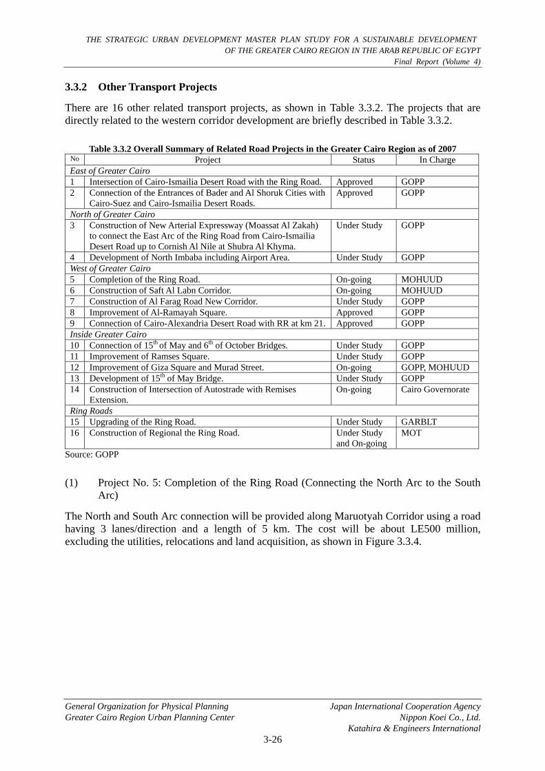
3.3.2 Other Transport Projects
There are 16 other related transport projects, as shown in Table 3.3.2. The projects that are directly related to the western corridor development are briefly described in Table 3.3.2.
Table 3.3.2 Overall Summary of Related Road Projects in the Greater Cairo Region as of 2007 No Project Status In Charge East of Greater Cairo 1 Intersection of Cairo-Ismailia Desert Road with the Ring Road. Approved GOPP 2 Connection of the Entrances of Bader and Al Shoruk Cities with
Cairo-Suez and Cairo-Ismailia Desert Roads. Approved GOPP
North of Greater Cairo 3 Construction of New Arterial Expressway (Moassat Al Zakah)
to connect the East Arc of the Ring Road from Cairo-Ismailia Desert Road up to Cornish Al Nile at Shubra Al Khyma.
Under Study GOPP
4 Development of North Imbaba including Airport Area. Under Study GOPP West of Greater Cairo 5 Completion of the Ring Road. On-going MOHUUD 6 Construction of Saft Al Labn Corridor. On-going MOHUUD 7 Construction of Al Farag Road New Corridor. Under Study GOPP 8 Improvement of Al-Ramayah Square. Approved GOPP 9 Connection of Cairo-Alexandria Desert Road with RR at km 21. Approved GOPP Inside Greater Cairo 10 Connection of 15th of May and 6th of October Bridges. Under Study GOPP 11 Improvement of Ramses Square. Under Study GOPP 12 Improvement of Giza Square and Murad Street. On-going GOPP, MOHUUD 13 Development of 15th of May Bridge. Under Study GOPP 14 Construction of Intersection of Autostrade with Remises
Extension. On-going Cairo Governorate
Ring Roads 15 Upgrading of the Ring Road. Under Study GARBLT 16 Construction of Regional the Ring Road. Under Study
and On-going MOT
Source: GOPP
(1) Project No. 5: Completion of the Ring Road (Connecting the North Arc to the South Arc)
The North and South Arc connection will be provided along Maruotyah Corridor using a road having 3 lanes/direction and a length of 5 km. The cost will be about LE500 million, excluding the utilities, relocations and land acquisition, as shown in Figure 3.3.4.

THE STRATEGIC URBAN DEVELOPMENT MASTER PLAN STUDY FOR A SUSTAINABLE DEVELOPMENT OF THE GREATER CAIRO REGION IN THE ARAB REPUBLIC OF EGYPT
Final Report (Volume 4)
General Organization for Physical Planning Japan International Cooperation Agency Greater Cairo Region Urban Planning Center Nippon Koei Co., Ltd. Katahira & Engineers International
3-27
Intersection in the north part
Route Map of Maruotyah Corridor Intersection in the south part Source: GOPP
Figure 3.3.4 Connection of North Arc and South Arc of the Ring Road
(2) Project No. 6: Construction of Saft Al Labn Corridor
The first phase for upgrading the Saft Al Labn Corridor from the Ring Road to Tharwat Bridge in the Cairo University Area is under way. This includes construction of an elevated fly-over having a length of 815 m, a two-level viaduct having a length of 1,500 m and a one-way direction bridge having a length of 1000 m.
Maruotyah Corridor
Proposed Elevated Road Intersection with Ring Road Ring Road Existing Road
Proposed Elevated Road Intersection with Ring RoadRing Road Existing Road
Proposed Elevated Road Intersection with Ring RoadRing Road Existing Road

THE STRATEGIC URBAN DEVELOPMENT MASTER PLAN STUDY FOR A SUSTAINABLE DEVELOPMENT OF THE GREATER CAIRO REGION IN THE ARAB REPUBLIC OF EGYPT
Final Report (Volume 4)
General Organization for Physical Planning Japan International Cooperation Agency Greater Cairo Region Urban Planning Center Nippon Koei Co., Ltd. Katahira & Engineers International
3-28
Proposed Road on the Ground(L = 815 m)
Route Map (from the Ring Road to Tharwat Bridge in the Cairo University Area, 1st Phase)
Cross-section of Viaduct Part (L = 1,800 m)
Cross-section of Elevated Road Part (L = 1,000 m)
Proposed Viaduct(L = 1,800 m)
Proposed Elevated Road(L = 1,000 m)
Existing Bridges and Roads
Source: GOPP Figure 3.3.5 Upgrading of Saft Al Labn Corridor
Widening of Tharawt Bridge next to the Cairo University is under way, with the addition of one extra lane for each direction. As a result, the entrance and exit of Tharwat Bridge will be widened to 3 lanes in front of Kasm-Bulak. Connection of the Saft Al Labn Corridor with Sudan Street through the entrance and exit is also on-going, as shown in Figure 3.3.6.

THE STRATEGIC URBAN DEVELOPMENT MASTER PLAN STUDY FOR A SUSTAINABLE DEVELOPMENT OF THE GREATER CAIRO REGION IN THE ARAB REPUBLIC OF EGYPT
Final Report (Volume 4)
General Organization for Physical Planning Japan International Cooperation Agency
Source: GOPP Figure 3.3.6 Upgrading of Tharwat Bridge
Following upgrading of the Saft Al Labn Corridor (First Phase), which is on-going, the second Phase 2 upgrading of this corridor will continue from Tharwat Bridge to El Gamah Bridge, as shown in Figure 3.3.7. This work is currently being planned.
Route Map (from Thawat Bridge to Al Gamaa Bridge, 2nd Phase)
Typical Tunnel Cross Section at University and Orman Garden
Typical Cross Section of Tunnel Entrance, 250 m length, in front of Orman Garden
Bridges Tunnels Surface Roads
Source: GOPP Figure 3.3.7 Upgrading of Saft Al Labn Corridor from Tharwat Bridge to El Gamah Bridge
Greater Cairo Region Urban Planning Center Nippon Koei Co., Ltd. Katahira & Engineers International
3-29

THE STRATEGIC URBAN DEVELOPMENT MASTER PLAN STUDY FOR A SUSTAINABLE DEVELOPMENT OF THE GREATER CAIRO REGION IN THE ARAB REPUBLIC OF EGYPT
Final Report (Volume 4)
General Organization for Physical Planning Japan International Cooperation Agency
(3) Project No. 7: Construction of Al Farag Road New Corridor
Four (4) km elevated bridge from Al Farag Road Bridge to the Ring Road and twenty (20) km elevated road (viaduct) from the Ring Road to Cairo-Alexandria Desert Road at km 32 is under study (Figure 3.3.8).
Greater Cairo Region Urban Planning Center Nippon Koei Co., Ltd. Katahira & Engineers International
3-30
Rod Al-Farag Corridor
26th of July Road
Ring Road
6th of October
Faysal Road
Alexandria Desert Road Rod Al-Farag Corridor
26th of July Road
Ring Road
Faysal Road
Alexandria Desert Road
6th of October
General Route Map
Route Map (from the Ring Road to Al Farag Road Bridge (L = 4 km))
Route Map (from the Ring Road to Cairo-Alexandria Desert Road at km 32 (L = 20 km)) Source: GOPP
Figure 3.3.8 New Corridor of Al Farag Road

THE STRATEGIC URBAN DEVELOPMENT MASTER PLAN STUDY FOR A SUSTAINABLE DEVELOPMENT OF THE GREATER CAIRO REGION IN THE ARAB REPUBLIC OF EGYPT
Final Report (Volume 4)
General Organization for Physical Planning Japan International Cooperation Agency
(4) Project No. 8: Improvement of Al-Ramayah Square
The following projects were studied and have been approved. The project section has a length of about 5 km, the ROW is about 20 Feddan, and the cost is about LE380 million, excluding utilities, relocation and land acquisition as shown in Figure 3.3.9.
• Widening of existing Ring Road to become 4-lanes per each direction.
• Removing the exit from the Ring Road to Cairo-Alexandria Desert Road.
• Widening the extension of the Ring Road up to the proposed new road along the High Voltage Power Line
Part of Ring Road to be widened and extended Part of Ring Road to be widened and extended
Source: GOPP Figure 3.3.9 Improvement of Al-Ramayah Square
(5) Project No. 9: Connection of Cairo-Alexandria Desert Road with the Ring Road at km 21
Connection of Cairo-Alexandria Desert Road with the Ring Road at km 21 was studied and has been approved. It includes a) removing the exit from the Ring Road to the Cairo-Alexandria Desert Road, b) widening of existing the Ring Road to 4-lanes per each direction, c) extension of the Ring Road branch up to the proposed new road along the High Voltage Power Line, d) construction of the intersection of the proposed new road with Cairo-Alexandria Desert Road, and e) construction of the intersection of the proposed new road with Al Wahat Road.
Greater Cairo Region Urban Planning Center Nippon Koei Co., Ltd. Katahira & Engineers International
3-31

THE STRATEGIC URBAN DEVELOPMENT MASTER PLAN STUDY FOR A SUSTAINABLE DEVELOPMENT OF THE GREATER CAIRO REGION IN THE ARAB REPUBLIC OF EGYPT
Final Report (Volume 4)
General Organization for Physical Planning Japan International Cooperation Agency
Location Map
Cross section of the Ring Road before widening
Ring Road
Greater Cairo Region Urban Planning Center Nippon Koei Co., Ltd. Katahira & Engineers International
3-32
Removal the exit from the Ring Road to Cairo Alexandria Desert Road Widening of the Existing Ring Road to 4-lanes
Widening of Al-Wahat Road Extension of the Ring Road Branch along the High Voltage Power Line
Proposed Part of Widening Ring Road Proposed Part of Widening
Al
Cross section of the Ring Road before widening
-Wahat Road Proposed Part of Widening
Al-Wahat Road Proposed Part of Widening

THE STRATEGIC URBAN DEVELOPMENT MASTER PLAN STUDY FOR A SUSTAINABLE DEVELOPMENT OF THE GREATER CAIRO REGION IN THE ARAB REPUBLIC OF EGYPT
Final Report (Volume 4)
General Organization for Physical Planning Japan International Cooperation Agency
Intersection of New Road with Cairo-Alexandria Desert Road Intersection of New Road with Al-Wahat Road
Greater Cairo Region Urban Planning Center Nippon Koei Co., Ltd. Katahira & Engineers International
3-33
Source: GOPP Figure 3.3.10 Connection of Cairo-Alexandria Desert Road with the Ring Road at km 21
(6) Project No. 10: Connection of 15th of May and 6th of October Bridge
This project, which is now under study, is for constructing a tunnel in Cornish Al Nile for the direction from 15th of May to 6th of October. The tunnel will have a 10.5 m width and a height of 5.25 m. The cost is estimated at LE75 million.
Source: GOPP Figure 3.3.11 Connection Tunnel of 15th of May Bridge and 6th of October Bridge
Traffic Tunnel Surface Road
Part of Ring Road to be widened and extended
Traffic Tunnel Surface Road
Part of Ring Road to be widened and extended
Typical Cross-section of Intersection Typical Cross-section of New Road
(Al-Abrag)

THE STRATEGIC URBAN DEVELOPMENT MASTER PLAN STUDY FOR A SUSTAINABLE DEVELOPMENT OF THE GREATER CAIRO REGION IN THE ARAB REPUBLIC OF EGYPT
Final Report (Volume 4)
General Organization for Physical Planning Japan International Cooperation Agency
(7) Project No. 13: Improvement of 15th of May Bridge
This project is currently under study, and two alternatives are being considered. Alternative 1 is a) widening of exiting bridge by one lane per direction from Sphinx to Cornish and b) widening the bridge over Al Bahr Al Aimaa by 2 lanes per direction. Alternative 2 is a) construction of a down grade from 26th of July to Cornish of 7 m width and b) construction of a down grade to Cornish over Al Bahr Al Aimaa and to Zamalek of 7 m width. It will cost LE50 million.
Greater Cairo Region Urban Planning Center Nippon Koei Co., Ltd. Katahira & Engineers International
3-34
An exit from 26th of July to Cornish (7 m wide, 25 million LE.) An exit to Cornish over Al-Bahr Al-Aimaa to Zamalek (7 m wide, 50 million LE.)
Existing Tunnel Existing Bridge
Source: GOPP Figure 3.3.12 Improvement of 15th of May Bridge (Alternative 2)
(8) Project No. 15: Upgrading of the Ring Road
The main objective of upgrading of the Greater Cairo Ring Road is to form an integrated transport corridor. Investigations are being undertaken to determine the present operational conditions of the Ring Road and assess the technical and economic feasibility of the options to upgrade it to freeway standards. In addition, the feasibility of introducing a new Rapid Transit System is being assessed. This system would include park-and-ride facilities, pedestrian access, local area bus facilities and integration elements.
Development of the Ring Road as an integrated transport corridor is part of the long term plan of the Ministry of Transportation. Basically, two multi-modal solutions are envisaged: a Rapid Rail Transit System (RRTS) and Rapid Bus Transit System (RBTS).

THE STRATEGIC URBAN DEVELOPMENT MASTER PLAN STUDY FOR A SUSTAINABLE DEVELOPMENT OF THE GREATER CAIRO REGION IN THE ARAB REPUBLIC OF EGYPT
Final Report (Volume 4)
General Organization for Physical Planning Japan International Cooperation Agency
Source: GOPP
Figure 3.3.13 Ring Road Development
(9) Project No. 16: Construction of a Regional Ring Road
A Regional Ring Road Project is under study, but is partly on going. As presented in Figure 3.3.14, the Regional Ring Road has a radius of about 100 km around GCR. Based on a review of previous studies, GOPP has given priority to the southern part of this Regional Ring Road to integrate suburban economic agglomerations into a wider metropolitan region, and to provide functional linkages between GCR and the other regional centers.
Source: GOPP Figure 3.3.14 Regional Ring Road
Greater Cairo Region Urban Planning Center Nippon Koei Co., Ltd. Katahira & Engineers International
3-35