Embed Size (px)
Citation preview
The condition and accessibility of the transportation system has major implicationsfor both the economic health and the quality of life of residents in the Donegal Area.Decisions on what types of business will be attracted and where they will locate aredetermined by the ease which both individuals and goods can be moved. The abilityof the Donegal area’s transportation system to effectively move both visitors andresidents is crucial to both the present economy and future growth and development.The Transportation section examines the issues and concerns regardingtransportation within the project area, and lays the basis for understanding howdevelopment is shaped by the transportation network.
Donegal’s location along the Pennsylvania Turnpike means that it has specialtransportation needs unique from many other rural areas. The Donegal exit of theTurnpike acts as a gateway for thousands of tourists who travel to variousdestinations throughout the southern portion of the Laurel Highlands. Destinationssuch as the ski resorts of Hidden Valley and Seven Springs, as well as the nearbytown of Ligonier can be reached via Donegal and congestion is not uncommon,especially during the peak leaf viewing times of the fall and the winter ski season.
3.3
…T
ran
spor
tati
on
Section 3…Background Studies
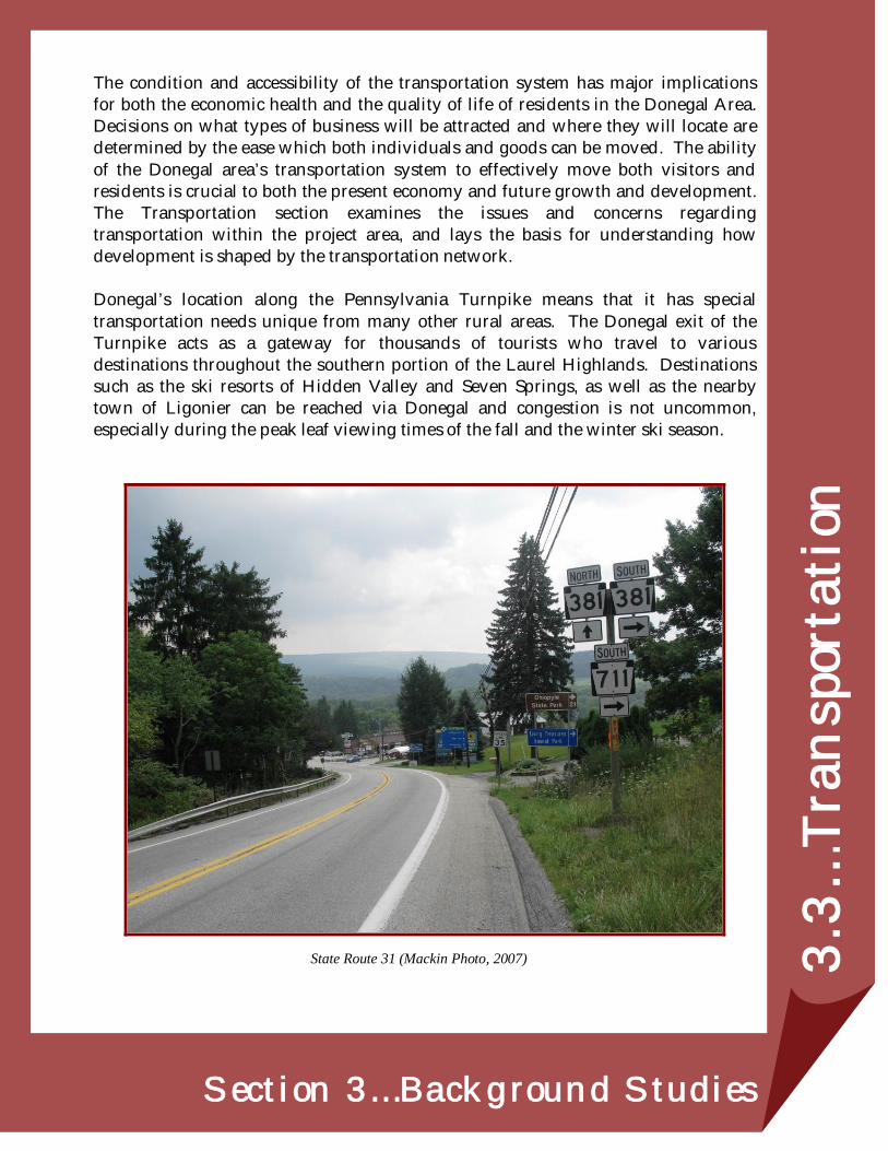
State Route 31 (Mackin Photo, 2007)
Donegal Borough & Donegal Township
3.3-2
PREVIOUS TRANSPORTATION PLANNING
Westmoreland County Comprehensive Plan
The Westmoreland County Comprehensive Plan was adopted in December 2004;part of the planning process was the crafting of ten principals to guide plans anddevelopment. Four of these guiding principals deal directly with transportation.
1) “Prioritize transportation improvements that reduce travel time fromkey areas of the county, thus reducing congestion on local highways.”
2) “Implement planning techniques and enforce development standardsthat cluster commercial development and discourage the proliferationof curb cuts on commercial highways.”
3) “Provide more options and fewer roadblocks to varieties of housingtypes … utilize design techniques that instill a sense of place, andreduce travel time for every day purchases.”
4) “Construction of new turnpike “EZPass” interchanges at State Routes130 and 981.”
The Westmoreland County Comprehensive Plan does not specifically addressconcerns related to the Donegal Area nor does it offer recommendations forfuture development related to transportation improvements. However, for thepurposes of this Comprehensive Plan, transportation related issues and concernsfor the Donegal Area are addressed using the related guiding principals set forthin the Westmoreland County Comprehensive Plan. Additionally,recommendations are made in a manner that seeks to best address the goals andpriorities of other local and regional planning agencies.
REGIONAL TRANSPORTATION NETWORK
The Pennsylvania Department of Transportation (PennDOT) classifies all state-ownedroads according to functional classifications. The classification of a roadway relates toits basic relationship to traffic levels of service and access. For example: Arterialsprovide a higher level of service and a greater deal of access control, while Local Roadsprovide the highest level of access, but provide much lower levels of service.
Collector roads provide a balance between mobility and access. For the purpose of thisplan, PennDOT Functional Classifications will be used to describe the road inventory.The road network is graphically shown on Map 3.3A: Local Transportation Network.
Joint Comprehensive Plan
Final Draft: 7/28/2008 3.3-3
ROADWAY CLASSIFICATIONS
Interstate Highways
The Pennsylvania interstate system includes presently designated interstateroutes that meet the federal interstate geometric and construction standards forfuture traffic demands. This designation is the highest classification of arterialroads and provides the highest level of service at the highest speed for thelongest uninterrupted distances (Penn DOT, 2005). Designed to be the safest,all-weather highway network in the United States, the system was originallydesigned for national defense.
Interstate 76/70 Pennsylvania Turnpike
Interstate 70 and Interstate 76 (PA Turnpike) is a limited access, InterstateHighway that was constructed as part of the Pennsylvania TurnpikeSystem. The highway transverses Donegal Township east west andprovides connections to Pittsburgh to the west, and Harrisburg andPhiladelphia to the east. The Donegal Interchange (PA Turnpike Exit 91)is located in Donegal Township and provides direct access to State Route31 heading east and west.
As the principal connection between Philadelphia and Pittsburgh and theWashington D.C./Baltimore area and points west, combined Interstate76/70 through Westmoreland County is a heavily traveled highway.Traffic counts along this roadway range from 36,000 to 45,000 vehiclesdaily.
According to information provided by the Pennsylvania TurnpikeCommission (B. Heigel, personal communication, December 19 2007), theTurnpike does not have any planned improvements for the Donegalinterchange although the Pennsylvania Department of Transportationdoes have a planned intersection improvement scheduled for State Route31. However, the turnpike itself has gone through significantreconstruction over the past few years. Beginning in 2002, areconstruction project to completely rebuild the turnpike betweenmileposts 85 and 94 was undertaken. This multi-year $66 million projectrebuilt the old roadbeds, widened lanes of traffic and created newshoulders to improve traveler safety.
Donegal Borough & Donegal Township
3.3-4
Pennsylvania Turnpike 66
Pennsylvania Turnpike 66 is a toll highway that begins at the interchangeof Interstate 76, and Interstate 70 and US 119. The toll road connects toregional arterials and US 22 at its northern terminus. This roadwayprovides access from Interstate 76/70 to US Route 30 and US Route 22,which are two of the primary arterials to job and population centers ineastern Allegheny County.
Interstate I-70
Interstate 70 is an east to west limited access roadway that entersWestmoreland County from Washington County and shares analignment with the Pennsylvania Turnpike 76 beginning at New Stanton.This roadway serves a major freight corridor for heavy trucks as well as athoroughfare for out of state vehicular traffic and local trips.
Principal Arterials
Principal arterials provide statewide or interstate travel to urbanized areas.They provide integrated movements without stub connections. Design of theroadway usually consists of two (2) 12-foot lanes with 8 to 10 foot shoulderswith speeds typically ranging from 45 to 65 miles per hour.
There are no roadways classified as Principal Arterials in the Donegal Area,however, connections to principal arterials in the region can be made via thePennsylvania Turnpike and State Route 711.
US Route 30
US Route 30 is an east-west highway that bisects Westmoreland Countyfrom the Allegheny County line to Somerset County and formsWestmoreland County’s primary commercial corridor. US 30 offersaccess to regional business centers such as Greensburg, NorthHuntington Township and eastern Allegheny County via connectionsfrom Interstate 76/70.
Minor Arterial Highway
Minor arterials link cities, larger towns and other traffic generators to provideintegrated interstate and inter-county service. Minor arterials are spaced atproper intervals consistent with population density. Design of the roadway
Joint Comprehensive Plan
Final Draft: 7/28/2008 3.3-5
usually consists of two (2) 12-foot lanes with 8 to 10 foot shoulders and speedstypically ranging from 35 to 45 miles per hours.
Minor arterial highways in the Donegal Area are State Route 31 and State Route711. These routes are the primary routes to and from destinations in Donegal.Most roads in the Donegal Area connect to either State Route 31 or State Route711.
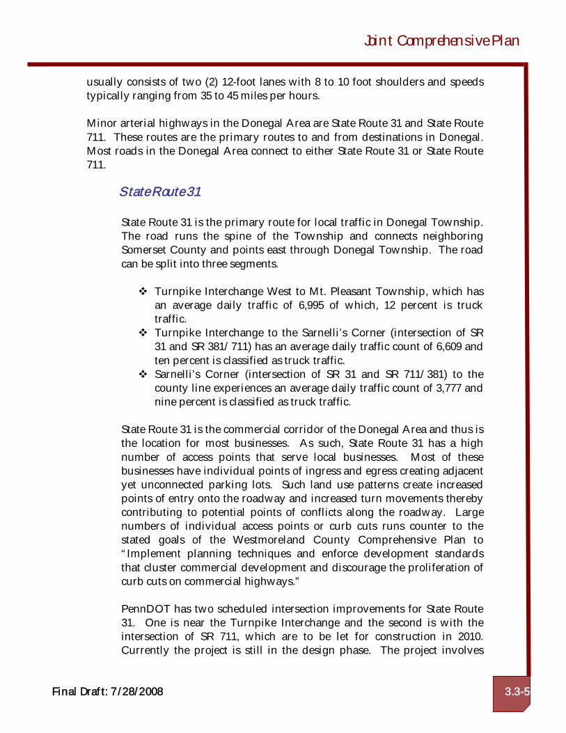
State Route 31
State Route 31 is the primary route for local traffic in Donegal Township.The road runs the spine of the Township and connects neighboringSomerset County and points east through Donegal Township. The roadcan be split into three segments.
Turnpike Interchange West to Mt. Pleasant Township, which hasan average daily traffic of 6,995 of which, 12 percent is trucktraffic.Turnpike Interchange to the Sarnelli’s Corner (intersection of SR31 and SR 381/711) has an average daily traffic count of 6,609 andten percent is classified as truck traffic.Sarnelli’s Corner (intersection of SR 31 and SR 711/381) to thecounty line experiences an average daily traffic count of 3,777 andnine percent is classified as truck traffic.
State Route 31 is the commercial corridor of the Donegal Area and thus isthe location for most businesses. As such, State Route 31 has a highnumber of access points that serve local businesses. Most of thesebusinesses have individual points of ingress and egress creating adjacentyet unconnected parking lots. Such land use patterns create increasedpoints of entry onto the roadway and increased turn movements therebycontributing to potential points of conflicts along the roadway. Largenumbers of individual access points or curb cuts runs counter to thestated goals of the Westmoreland County Comprehensive Plan to“Implement planning techniques and enforce development standardsthat cluster commercial development and discourage the proliferation ofcurb cuts on commercial highways.”
PennDOT has two scheduled intersection improvements for State Route31. One is near the Turnpike Interchange and the second is with theintersection of SR 711, which are to be let for construction in 2010.Currently the project is still in the design phase. The project involves
Donegal Borough & Donegal Township
3.3-6
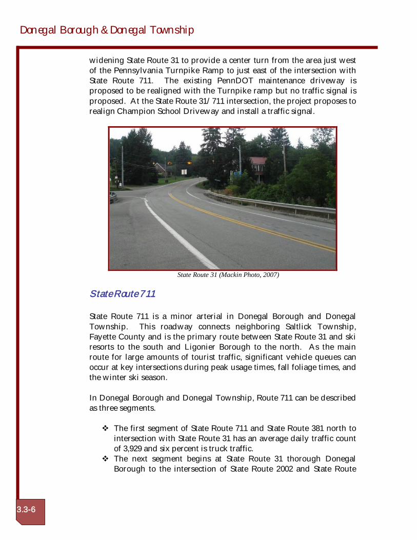
widening State Route 31 to provide a center turn from the area just westof the Pennsylvania Turnpike Ramp to just east of the intersection withState Route 711. The existing PennDOT maintenance driveway isproposed to be realigned with the Turnpike ramp but no traffic signal isproposed. At the State Route 31/711 intersection, the project proposes torealign Champion School Driveway and install a traffic signal.
State Route 31 (Mackin Photo, 2007)
State Route 711
State Route 711 is a minor arterial in Donegal Borough and DonegalTownship. This roadway connects neighboring Saltlick Township,Fayette County and is the primary route between State Route 31 and skiresorts to the south and Ligonier Borough to the north. As the mainroute for large amounts of tourist traffic, significant vehicle queues canoccur at key intersections during peak usage times, fall foliage times, andthe winter ski season.
In Donegal Borough and Donegal Township, Route 711 can be describedas three segments.
The first segment of State Route 711 and State Route 381 north tointersection with State Route 31 has an average daily traffic countof 3,929 and six percent is truck traffic.The next segment begins at State Route 31 thorough DonegalBorough to the intersection of State Route 2002 and State Route
Joint Comprehensive Plan
Final Draft: 7/28/2008 3.3-7
711. This segment has an average daily traffic count of 3,912 andhas six percent truck traffic.The last segment begins at the intersection of State Route 2002 andState Route 711 and continues north to the Cook Township line.This segment has eight percent truck traffic and an average dailytraffic count of 4,246.
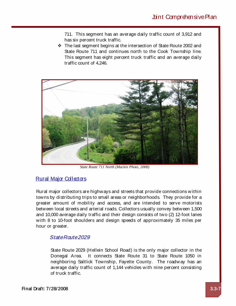
State Route 711 North (Mackin Photo, 2008)
Rural Major Collectors
Rural major collectors are highways and streets that provide connections withintowns by distributing trips to small areas or neighborhoods. They provide for agreater amount of mobility and access, and are intended to serve motoristsbetween local streets and arterial roads. Collectors usually convey between 1,500and 10,000 average daily traffic and their design consists of two (2) 12-foot laneswith 8 to 10-foot shoulders and design speeds of approximately 35 miles perhour or greater.
State Route 2029
State Route 2029 (Hellein School Road) is the only major collector in theDonegal Area. It connects State Route 31 to State Route 1050 inneighboring Saltlick Township, Fayette County. The roadway has anaverage daily traffic count of 1,144 vehicles with nine percent consistingof truck traffic.

Donegal Borough & Donegal Township
3.3-8
Rural Minor Collectors
Rural minor collector roads enable moderate quantities of traffic to movebetween arterial and local roads. These roadways provide for an equal amountmobility and access by allowing direct connections to adjoining property. Ruralminor collector roads are usually designed with two (2) 12-foot lanes, 4 to 10foot shoulders, and design speeds of approximately 30 miles per hour.
Rural minor collectors in the Donegal Area include:
State Route 381
State Route 381 begins in Fayette County where it shares an alignmentwith State Route 711. The roadway leaves the shared alignment at StateRoute 31 near the Jones Mills community. As State Route 381 continuesnorth, it averages 450 daily vehicles and has the highest level of trucktraffic at 19 percent. The roadway eventually ends at its intersection withUS Route 30 in Ligonier Township.
State Route 381 North (Mackin Photo, 2008)
State Route 130
State Route 130 traverse Westmoreland County in a west to east fashionentering the county near Trafford and terminating at the intersection
Joint Comprehensive Plan
Final Draft: 7/28/2008 3.3-9
with State Route 381 near the Donegal/Cook Township boundary. Dueto the length of the corridor, it can be split into three segments.
Segment one begins at the southern most point Turnpike to thefour way intersection with State Route 2031 at the Village ofStahlstown. This segment has an average daily traffic of 519 withnine percent truck traffic.The second segment begins at State Route 2031 to the four wayintersection of State Route 2004. This segment has an averagedaily traffic of 246 with nine percent truck traffic.The third segment begins at State Route 2004 and ends at theMount Pleasant Township Line. This segment has 742 averagedaily trips reported on it and has nine percent truck traffic.
Local Roads
Local Roads are designed to provide direct access to access to adjacentproperties. Local roads are intended to only provide for transportation within aparticular neighborhood, or to one of the other described road types. Localroads are usually designed to be 20 to 22 feet wide with 2 to 8-foot shouldersand design speeds of approximately 25 miles per hour.
State Route 2031
State Route 2031 (Jones Mills Stahlstown Road) is the only state routeclassified as a local road in the Donegal Area. The roadway begins at thejunction of State Route 31 with State Route 711/381, and continues northwhere it enters Cook Township at Village of Stahlstown. State Route2031 is the least traveled state route in Donegal with an annual averagedaily traffic count of 116 of which nine percent of that is truck traffic.
Gravel Roads
According to the Federal Highway Administration, there are over 1.6 millionmiles of unpaved roads (53% of all roads) in the United States. Gravel roads aregenerally the lowest service provided to the traveling public and are oftenthought to be less desirable than paved roads. However, in rural areas such asDonegal Township, the volume of traffic is so low that paving and maintaininga paved road is not economically feasible. Donegal Township has a severalgravel roadways.
Donegal Borough & Donegal Township
3.3-10
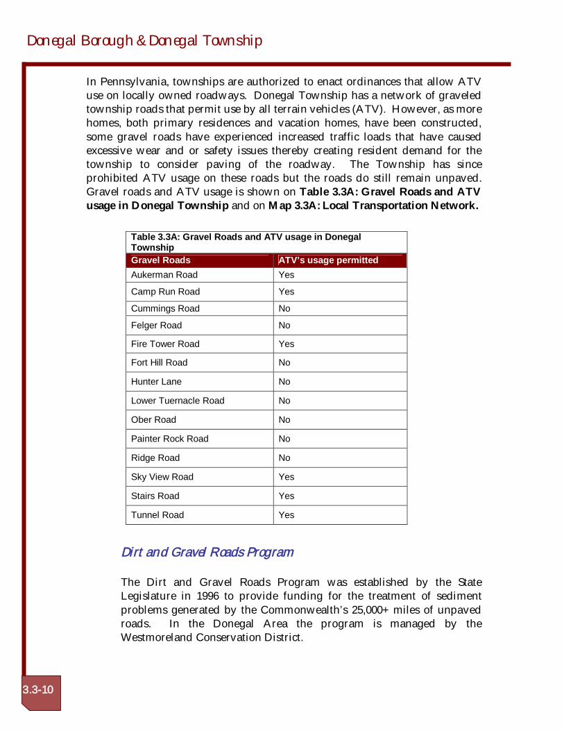
In Pennsylvania, townships are authorized to enact ordinances that allow ATVuse on locally owned roadways. Donegal Township has a network of graveledtownship roads that permit use by all terrain vehicles (ATV). However, as morehomes, both primary residences and vacation homes, have been constructed,some gravel roads have experienced increased traffic loads that have causedexcessive wear and or safety issues thereby creating resident demand for thetownship to consider paving of the roadway. The Township has sinceprohibited ATV usage on these roads but the roads do still remain unpaved.Gravel roads and ATV usage is shown on Table 3.3A: Gravel Roads and ATVusage in Donegal Township and on Map 3.3A: Local Transportation Network.
Dirt and Gravel Roads Program
The Dirt and Gravel Roads Program was established by the StateLegislature in 1996 to provide funding for the treatment of sedimentproblems generated by the Commonwealth’s 25,000+ miles of unpavedroads. In the Donegal Area the program is managed by theWestmoreland Conservation District.
Table 3.3A: Gravel Roads and ATV usage in DonegalTownshipGravel Roads ATV’s usage permittedAukerman Road Yes
Camp Run Road Yes
Cummings Road No
Felger Road No
Fire Tower Road Yes
Fort Hill Road No
Hunter Lane No
Lower Tuernacle Road No
Ober Road No
Painter Rock Road No
Ridge Road No
Sky View Road Yes
Stairs Road Yes
Tunnel Road Yes
Joint Comprehensive Plan
Final Draft: 7/28/2008 3.3-11
Pennsylvania’s Dirt and Gravel Road Pollution Prevention Programprovides grant funding to eliminate stream pollution caused by dust andsediment from unpaved roads. The program and its annual $5Mapportionment for “environmentally sound maintenance” were enactedinto law in April 1997, as Section 9106– PA Vehicle Code. Each year, theState Conservation Commission allocates this “dedicated and earmarkedfunding,” based on identified needs, to County Conservation Districts.Townships and other road-owning entities, after successful completion ofrequired 2-day “Environmentally Sensitive Maintenance” training applyto local Conservation Districts for these maintenance funds to addressidentified pollution problems using environmentally-sound roadmaintenance practices.
Donegal Township has completed several projects using the Dirt andGravel Program as listed below:
Portion of Oak Road- $11,000- Completed in Fall of 2006Lower Tabernacle Road- $7,000- Completed in Fall of 2006Fire Tower Road- $10,000- Completed in Fall of 2005Portion of Oak Road- $12,000- To be completed in 2008
The township has also received two Growing Greener Grants toimplement Dirt and Gravel Program practices, they are as follows:
Stairs Road- $40,000- To be completed in 2008Ridge Road- $2,000- To be completed in 2008
These projects will use control measures, such as piping, ditch work, andbuilding the road up to remove water off the road.
PENNSYLVANIA SCENIC BYWAY
The National Scenic Byways Program was created through the Federal IntermodalSurface Transportation Efficiency Act of 1991 (ISTEA). The goal of this program is torecognize and promote outstanding corridors throughout the United States, promotetourism, and protect the resources that make these hidden treasures outstanding. Inthe early 1990’s Pennsylvania received money to conduct a State Scenic Byways Study,which resulted in legislative action for the designation of four Scenic Byways. In 2001,the Pennsylvania began a state byways program that is managed through PennDOT.The state program designates Pennsylvania Byways at the request of the localcommunities seeking to highlight the six qualities- cultural, historical, recreational,archaeological, scenic and natural qualities. The benefits of this program can be many,
Donegal Borough & Donegal Township
3.3-12
but perhaps one of the most significant is the availability of federal funding toimplement projects on designated routes and to enhance, preserve, and sustain thequalities of the byway. There are eight categories that the funds can be used for: stateprograms, corridor management plans, safety improvements, byway facilities, access torecreation, resource protection and acquisition, interpretive information and marketing.Additional information is located at http://www.bywaysonline.org/grants/. Onecaveat of the Byways program is the restriction of outdoor advertising. Title 23 of theU.S. Code, Section 131, specifies that if a State has a State scenic byway program, theState may not allow the erection of new signs that do not conform with specificationsnoted in the Code along any scenic byway that was on the Federal Aid Primary (FAP)system in 1991 or is on the National Highway System (NHS) today.
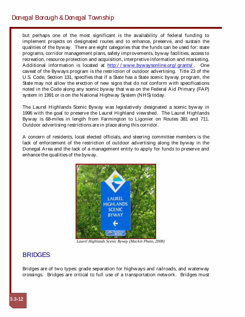
The Laurel Highlands Scenic Byway was legislatively designated a scenic byway in1996 with the goal to preserve the Laurel Highland viewshed. The Laurel HighlandsByway is 68-miles in length from Farmington to Ligonier on Routes 381 and 711.Outdoor advertising restrictions are in place along this corridor.
A concern of residents, local elected officials, and steering committee members is thelack of enforcement of the restriction of outdoor advertising along the byway in theDonegal Area and the lack of a management entity to apply for funds to preserve andenhance the qualities of the byway.
Laurel Highlands Scenic Byway (Mackin Photo, 2008)
BRIDGES
Bridges are of two types: grade separation for highways and railroads, and waterwaycrossings. Bridges are critical to full use of a transportation network. Bridges must
Joint Comprehensive Plan
Final Draft: 7/28/2008 3.3-13
comply with the following general criteria to satisfy their functional part of thetransportation system and the class of highway being bridged.
Support both dead and live loadsAdequate waterway openingVertical grade clearancePavement and shoulder aligned with roadwayParapet impact strengthDeck drainLoad sufficiency rating.
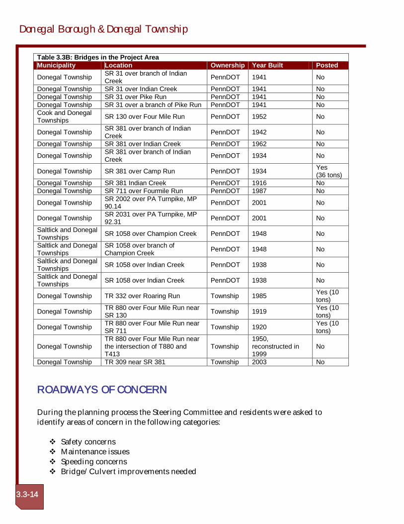
Bridges failing to satisfy these criteria become functionally inadequate and limit thehighways ability to serve the public. The most serious inadequacy is loss of structuralstrength that limits a bridge’s ability to carry design loads. When a bridge becomesstructurally inadequate, the bridge must be posted for a lower safe load, or closed, if asafe load is less than three tons. A typical ambulance is seven tons, school busses 12 to15 tons, fire engine 15+ tons, and delivery trucks 5+ tons. The only vehicles permittedon a three-ton posted structure are automobiles and small pick-up trucks. A three-tonposting is a hardship on the quality of life for residents and businesses using the postedstructure. Closed structures cause a greater hardship on residents by denying access orforcing lengthy detours. Posted and closed bridges cause safety, inconvenience, andrestricted mobility problems for residents, motorists, and public service (fire, police,utility, and parcel delivery). There are 20 PennDOT owned bridges in DonegalTownship, one which is posted. There are five township owned bridges in DonegalTownship, three are posted. Bridges are listed in Table 3.3B: Bridges in the ProjectArea.
Donegal Borough & Donegal Township
3.3-14
Table 3.3B: Bridges in the Project AreaMunicipality Location Ownership Year Built Posted
Donegal Township SR 31 over branch of IndianCreek PennDOT 1941 No
Donegal Township SR 31 over Indian Creek PennDOT 1941 NoDonegal Township SR 31 over Pike Run PennDOT 1941 NoDonegal Township SR 31 over a branch of Pike Run PennDOT 1941 NoCook and DonegalTownships SR 130 over Four Mile Run PennDOT 1952 No
Donegal Township SR 381 over branch of IndianCreek PennDOT 1942 No
Donegal Township SR 381 over Indian Creek PennDOT 1962 No
Donegal Township SR 381 over branch of IndianCreek PennDOT 1934 No
Donegal Township SR 381 over Camp Run PennDOT 1934 Yes(36 tons)
Donegal Township SR 381 Indian Creek PennDOT 1916 NoDonegal Township SR 711 over Fourmile Run PennDOT 1987 No
Donegal Township SR 2002 over PA Turnpike, MP90.14 PennDOT 2001 No
Donegal Township SR 2031 over PA Turnpike, MP92.31 PennDOT 2001 No
Saltlick and DonegalTownships SR 1058 over Champion Creek PennDOT 1948 No
Saltlick and DonegalTownships
SR 1058 over branch ofChampion Creek PennDOT 1948 No
Saltlick and DonegalTownships SR 1058 over Indian Creek PennDOT 1938 No
Saltlick and DonegalTownships SR 1058 over Indian Creek PennDOT 1938 No
Donegal Township TR 332 over Roaring Run Township 1985 Yes (10tons)
Donegal Township TR 880 over Four Mile Run nearSR 130 Township 1919 Yes (10
tons)
Donegal Township TR 880 over Four Mile Run nearSR 711 Township 1920 Yes (10
tons)
Donegal TownshipTR 880 over Four Mile Run nearthe intersection of T880 andT413
Township1950,reconstructed in1999
No
Donegal Township TR 309 near SR 381 Township 2003 No
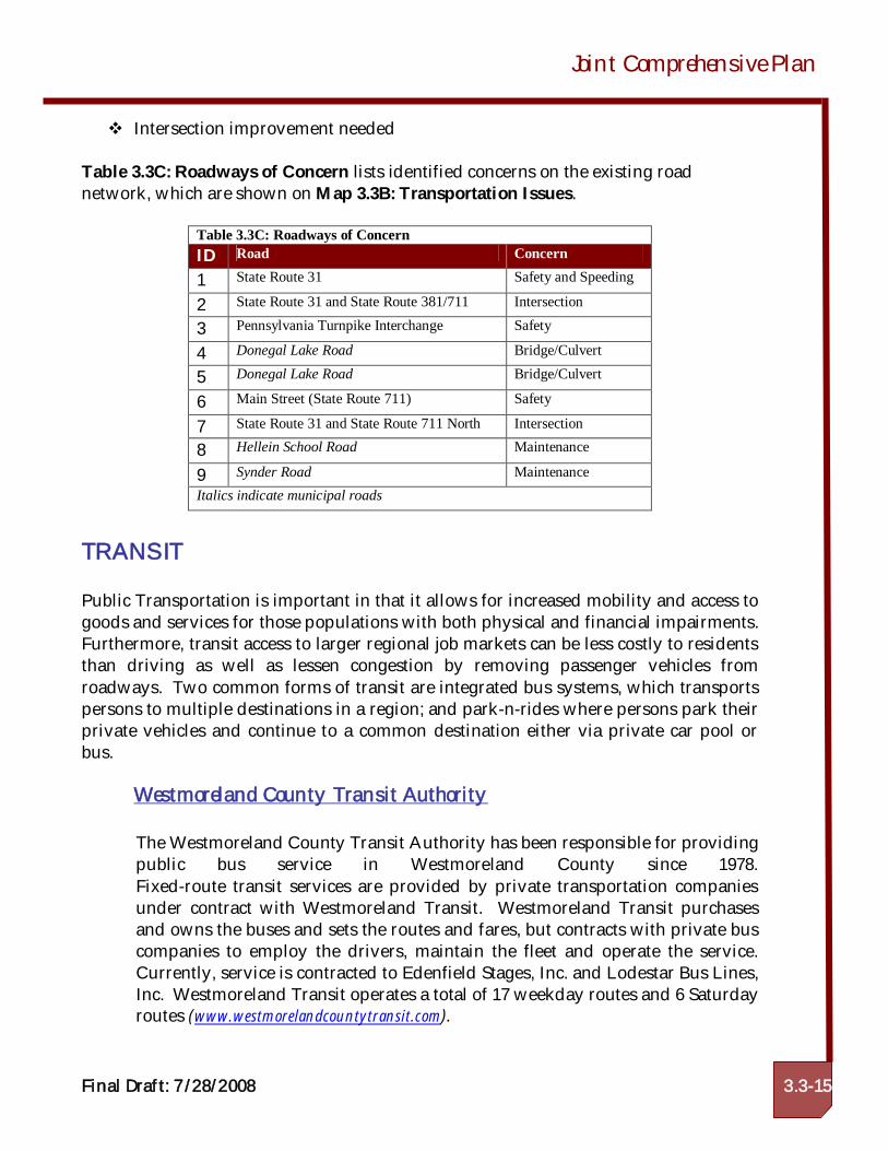
ROADWAYS OF CONCERN
During the planning process the Steering Committee and residents were asked toidentify areas of concern in the following categories:
Safety concernsMaintenance issuesSpeeding concernsBridge/Culvert improvements needed
Joint Comprehensive Plan
Final Draft: 7/28/2008 3.3-15
Intersection improvement needed
Table 3.3C: Roadways of Concern lists identified concerns on the existing roadnetwork, which are shown on Map 3.3B: Transportation Issues.
Table 3.3C: Roadways of ConcernID Road Concern
1 State Route 31 Safety and Speeding
2 State Route 31 and State Route 381/711 Intersection
3 Pennsylvania Turnpike Interchange Safety
4 Donegal Lake Road Bridge/Culvert
5 Donegal Lake Road Bridge/Culvert
6 Main Street (State Route 711) Safety
7 State Route 31 and State Route 711 North Intersection
8 Hellein School Road Maintenance
9 Synder Road MaintenanceItalics indicate municipal roads
TRANSIT
Public Transportation is important in that it allows for increased mobility and access togoods and services for those populations with both physical and financial impairments.Furthermore, transit access to larger regional job markets can be less costly to residentsthan driving as well as lessen congestion by removing passenger vehicles fromroadways. Two common forms of transit are integrated bus systems, which transportspersons to multiple destinations in a region; and park-n-rides where persons park theirprivate vehicles and continue to a common destination either via private car pool orbus.
Westmoreland County Transit Authority
The Westmoreland County Transit Authority has been responsible for providingpublic bus service in Westmoreland County since 1978.Fixed-route transit services are provided by private transportation companiesunder contract with Westmoreland Transit. Westmoreland Transit purchasesand owns the buses and sets the routes and fares, but contracts with private buscompanies to employ the drivers, maintain the fleet and operate the service.Currently, service is contracted to Edenfield Stages, Inc. and Lodestar Bus Lines,Inc. Westmoreland Transit operates a total of 17 weekday routes and 6 Saturdayroutes (www.westmorelandcountytransit.com).
Donegal Borough & Donegal Township
3.3-16
Although, Westmoreland County Transit provides bus service to and frommany locations in the county there is no mass transit service to either DonegalTownship or Donegal Borough. The closest locations with transit access are invarious locations throughout neighboring Mt. Pleasant Township. Servicesbeyond fixed route bus routes offered by Westmoreland County Transit include:
Senior Free Transit Program
This program is funded by the Pennsylvania Department of Transitutilizing Pennsylvania Lottery funds and provides free bus transit on anyWestmoreland County Transit bus for senior citizens age 65 and over.
Senior Free Transit Program
The Reduced Fare Transit Program offers persons with disabilities to ridea Westmoreland County transit bus for half the regular fee. The programis also open to seniors under the age of 65 who also posses a Medicarecard.
Medical Assistance Transportation Program
This program is funded by the Department of Public Welfare andprovides free transportation to medical appointments, via reimbursementfor private vehicle mileage, public bus, or taxi service, for personspossessing a valid Welfare Medical card.
Americans with Disabilities (ADA) Complementary ParatransitProgram
The ADA Complementary Para Transit Program provides taxis to deliverroute services mirroring those of the public bus service to WestmorelandCounty residents who have a disability that prohibits them from usingthe bus.
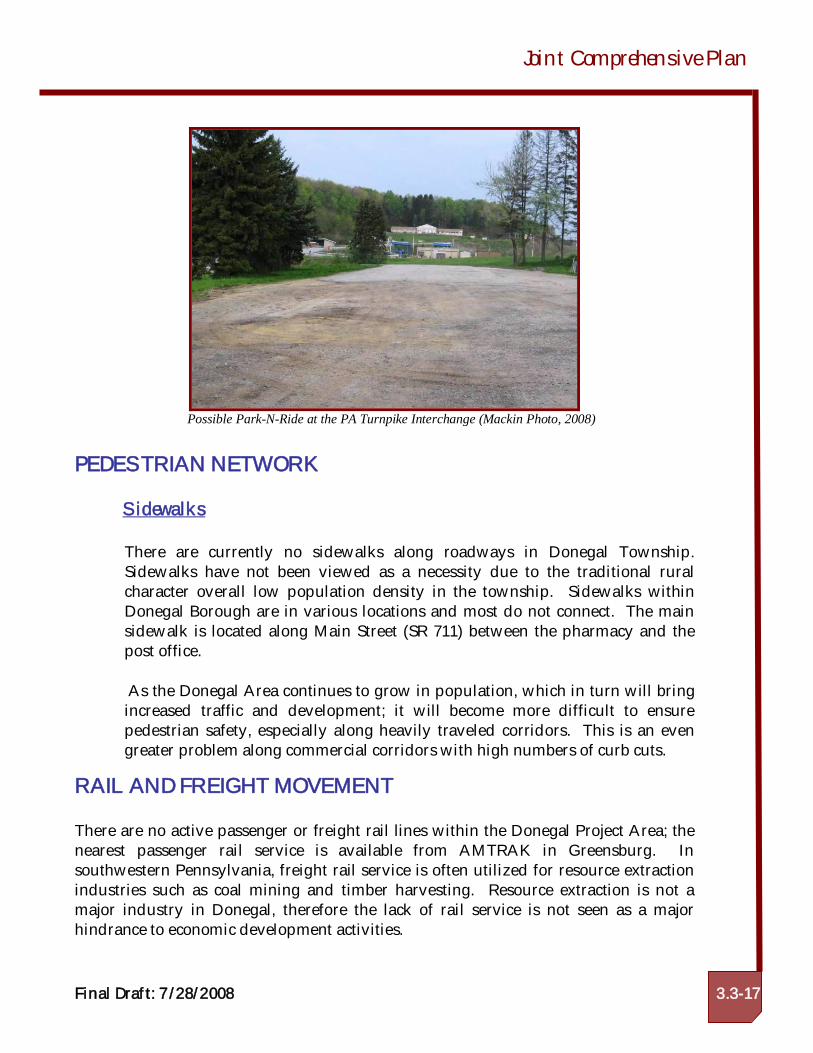
Park –n-Rides
There are no Park-N-Ride facilities in either Donegal Borough or DonegalTownship. The closest can be found at Arnold Palmer Regional Airport nearLatrobe and in North Huntington Township. The Steering Committee noted theneed for a Park-N-Ride within the Township. A possible location for a Park-N-Ride is located near the Turnpike Interchange.
Joint Comprehensive Plan
Final Draft: 7/28/2008 3.3-17
Possible Park-N-Ride at the PA Turnpike Interchange (Mackin Photo, 2008)
PEDESTRIAN NETWORK
Sidewalks
There are currently no sidewalks along roadways in Donegal Township.Sidewalks have not been viewed as a necessity due to the traditional ruralcharacter overall low population density in the township. Sidewalks withinDonegal Borough are in various locations and most do not connect. The mainsidewalk is located along Main Street (SR 711) between the pharmacy and thepost office.
As the Donegal Area continues to grow in population, which in turn will bringincreased traffic and development; it will become more difficult to ensurepedestrian safety, especially along heavily traveled corridors. This is an evengreater problem along commercial corridors with high numbers of curb cuts.
RAIL AND FREIGHT MOVEMENT
There are no active passenger or freight rail lines within the Donegal Project Area; thenearest passenger rail service is available from AMTRAK in Greensburg. Insouthwestern Pennsylvania, freight rail service is often utilized for resource extractionindustries such as coal mining and timber harvesting. Resource extraction is not amajor industry in Donegal, therefore the lack of rail service is not seen as a majorhindrance to economic development activities.
Donegal Borough & Donegal Township
3.3-18
In southwestern Pennsylvania, 70 percent of all freight is moved via tractor-trailertrucks. The 2004 Westmoreland County Comprehensive Plan states that consumergoods constitute most of the cargo for long haul trucking, but the region sees little localtruck traffic as consumer goods production is a small part of the local export base. Thisstatement is inconsistent with Donegal Area statistics. Standard truck percentages forstate routes are between three and four percent but in the Donegal Area thepercentages exceed this standard. State Route 381 North quadruples the standard at 19percent.
AIRPORTS
The closest commercial airport to Donegal is the Arnold Palmer Regional Airport innearby Unity Township. A 15-mile drive from the center of Donegal Borough, ArnoldPalmer Regional Airport is served by daily flight by Northwest Airlines to its hub inDetroit, Michigan. The airport also offers charter flights to popular vacationdestinations.
The closest airport offering service by multiple carriers, airfreight service andinternational flights is Pittsburgh International Airport, which is located approximately67 miles northwest of Donegal Borough. Pittsburgh International is easily assessablevia freeway connections from the Pennsylvania Turnpike I-76.
TRANSPORTATION RESOURCES
Southwestern Pennsylvania Commission
The Southwestern Pennsylvania Commission (SPC) is the federally-designatedMetropolitan Planning Organization (MPO) for a ten-county region includingthe City of Pittsburgh and the counties of Allegheny, Armstrong, Beaver, Butler,Fayette, Greene, Indiana, Lawrence, Washington, and Westmoreland. Theresponsibilities of a metropolitan planning organization include the planningand prioritizing of all state and federal transportation funds allocated to theregion and for conducting the transportation planning process for the region incooperation of PennDOT, Westmoreland County, and other SPC partners. Itshould also be recognized that SPC serves also as the Local DevelopmentDistrict (LDD) and Economic Development District for SouthwesternPennsylvania (as designated by the U.S. Appalachian Regional Commission andthe U.S. Department of Commerce), to establish regional economic developmentpriorities.
Joint Comprehensive Plan
Final Draft: 7/28/2008 3.3-19
SPC, through coordination with its planning partners, establishes priority needson the federal and state highway systems and directs funding through the SPCTransportation Improvement Program (TIP). The TIP is a four-year, fiscallyconstrained listing of priority multimodal projects. The TIP is updatedbiannually in conjunction with the state’s Twelve Year Transportation Program.A project must appear on the TIP before it can receive financial support. TheTIP represents the schedule and cost for the project at the time of TIPdevelopment and is the first step in seeking authorized funding.
The 2007-2010 TIP identifies the priority highway and transit improvementsprogrammed for advancement from October 1, 2006 through September 30,2010. The 2007-2010 TIP specifies the priorities for the region and includesreasonable estimates of both available funds and anticipated projectexpenditures.
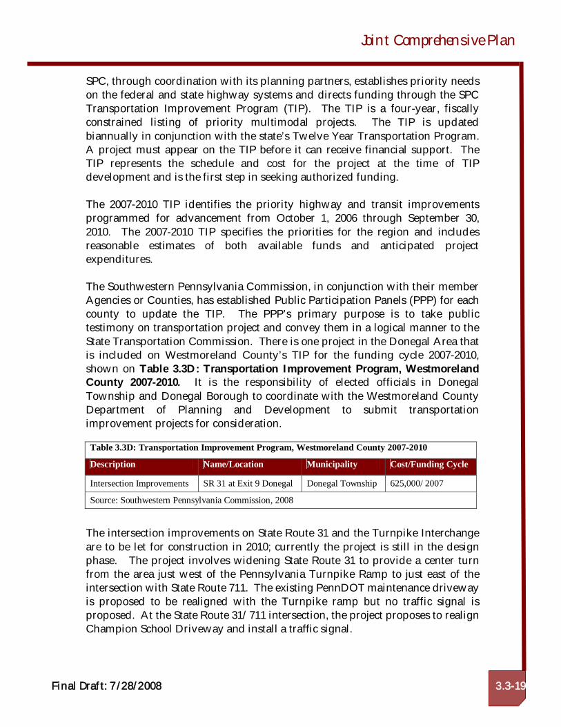
The Southwestern Pennsylvania Commission, in conjunction with their memberAgencies or Counties, has established Public Participation Panels (PPP) for eachcounty to update the TIP. The PPP’s primary purpose is to take publictestimony on transportation project and convey them in a logical manner to theState Transportation Commission. There is one project in the Donegal Area thatis included on Westmoreland County’s TIP for the funding cycle 2007-2010,shown on Table 3.3D: Transportation Improvement Program, WestmorelandCounty 2007-2010. It is the responsibility of elected officials in DonegalTownship and Donegal Borough to coordinate with the Westmoreland CountyDepartment of Planning and Development to submit transportationimprovement projects for consideration.
The intersection improvements on State Route 31 and the Turnpike Interchangeare to be let for construction in 2010; currently the project is still in the designphase. The project involves widening State Route 31 to provide a center turnfrom the area just west of the Pennsylvania Turnpike Ramp to just east of theintersection with State Route 711. The existing PennDOT maintenance drivewayis proposed to be realigned with the Turnpike ramp but no traffic signal isproposed. At the State Route 31/711 intersection, the project proposes to realignChampion School Driveway and install a traffic signal.
Table 3.3D: Transportation Improvement Program, Westmoreland County 2007-2010
Description Name/Location Municipality Cost/Funding Cycle
Intersection Improvements SR 31 at Exit 9 Donegal Donegal Township 625,000/ 2007
Source: Southwestern Pennsylvania Commission, 2008
Donegal Borough & Donegal Township
3.3-20
Other programs that are managed through SPC include the CongestionMitigation Air Quality Program (CMAQ) and Transportation Enhancements(TE). The purpose of the CMAQ program is to provide funds for transportationprojects or programs that will achieve or maintain the national ambient airquality standards for ozone, carbon monoxide and particulate matter. Projectsthat are funded include pedestrian improvements, transit services, and park andride locations. Transportation Enhancements are funds from the federalgovernment to expand travel choice, strengthen the local economy, improve thequality of life, and protect the environment. Transportation Enhancements (TE)activities are community-based projects that expand travel choices and enhancethe transportation experience by improving the cultural, historic, aesthetic, andenvironmental aspects of our transportation infrastructure. TE projects must beone of 12 eligible activities and must relate to surface transportation. Forexample, projects can include creation of bicycle and pedestrian facilities,streetscape improvements, refurbishment of historic transportation facilities,and other investments that enhance communities and access. The federalgovernment provides funding for TE projects through our nation’s surfacetransportation legislation. SPC administers this program for the Donegal Areaand applications are available every two years.
Pennsylvania Department of Transportation (PennDOT)
Westmoreland County is included under the PennDOT Engineering District 12,which also oversees state related transportation projects in Fayette, Greene, andWashington Counties. District 12 is responsible for over 3,715 miles of highway,more than 103 miles of interstate, and 2,397 state bridges. PennDOT cooperateswithin the framework of SPC to establish priorities for transportation projects.
PennDOT has established the Agility Program to help governments, schooldistricts, fire companies, and public utilities with special projects related totransportation needs. Activities can include boom mowing, street sweeping,bridge cleaning, providing meeting facilities, graphics, and storage. PennDOTalso works to remove litter and beautify roadways. Keep PA Beautiful is aPennDOT program that organizes volunteers to pick up trash and litter.PennDOT sponsors an annual clean up day, which is held the last Saturday ofApril.
Funding for road maintenance and construction at the local municipal level isgenerated through the Liquid Fuels Tax. The Liquid Fuels Tax Act 655, dated1956 and as amended provides all municipalities, which are in compliance withthe Department’s guidelines, with annual allocations on April 1 of each yearfrom the State’s Motor License Fund. The Act provides that these funds be used
Joint Comprehensive Plan
Final Draft: 7/28/2008 3.3-21
for road and bridge construction, reconstruction and maintenance projects. Thefunds are based on rations of mileage and population of the municipality to thestate totals. That is, 50 percent is based on a municipality’s local road mileage tothe total local road mileage in the state, and 50 percent on the proportion of amunicipality’s population to the total population for the state. A municipality’slocal road mileage is verified by periodic road surveys conducted by theMunicipal Services Unit. Population is based on official United States CensusReports conducted every ten years and reported to the Director of the Bureau ofMunicipal Services by December 31st. The Municipal Services Unit assists themunicipality in the appropriate use of the funds, (i.e., eligibility to receive funds,deposit of funds, invest funds, loan and bond issues, roadway and bridgemaintenance/repair, receipts and expenditures, and repaying the bank loans).The Liquid Fuels 2007 allocation for the project area is as follows:
Donegal Borough $3,520.81Donegal Township $144,402.44