Embed Size (px)
Citation preview
Heritage Statement
313-315 Caledonian Road, Islington, London
June 2016
Contents
1. Introduction 1
2. The Heritage Asset, Significance and Role of Nos. 313-315 Caledonian Road 3
3. Role of application building in the Significance of the Conservation Area 13
4. Local Views 16
5. Relevant Heritage Legislation & National Policy & Guidance 20
6. Impact Assessment 22
7. Summary and Conclusions 26
Client
OpticRealm Ltd
June 2016
1
1. Introduction
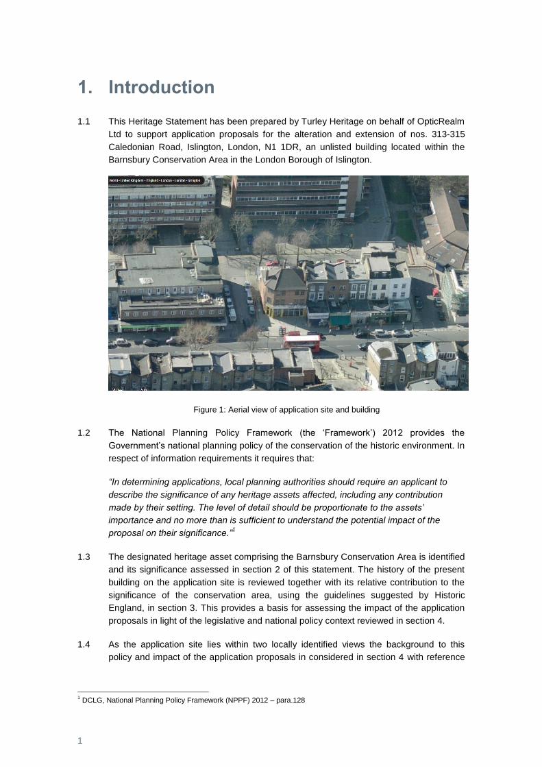
1.1 This Heritage Statement has been prepared by Turley Heritage on behalf of OpticRealm
Ltd to support application proposals for the alteration and extension of nos. 313-315
Caledonian Road, Islington, London, N1 1DR, an unlisted building located within the
Barnsbury Conservation Area in the London Borough of Islington.
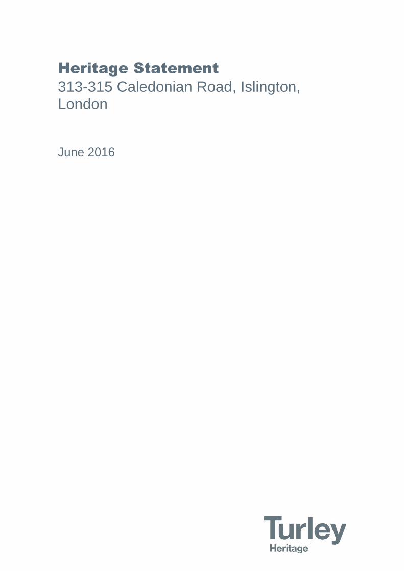
Figure 1: Aerial view of application site and building
1.2 The National Planning Policy Framework (the ‘Framework’) 2012 provides the
Government’s national planning policy of the conservation of the historic environment. In
respect of information requirements it requires that:
“In determining applications, local planning authorities should require an applicant to
describe the significance of any heritage assets affected, including any contribution
made by their setting. The level of detail should be proportionate to the assets’
importance and no more than is sufficient to understand the potential impact of the
proposal on their significance.”1
1.3 The designated heritage asset comprising the Barnsbury Conservation Area is identified
and its significance assessed in section 2 of this statement. The history of the present
building on the application site is reviewed together with its relative contribution to the
significance of the conservation area, using the guidelines suggested by Historic
England, in section 3. This provides a basis for assessing the impact of the application
proposals in light of the legislative and national policy context reviewed in section 4.
1.4 As the application site lies within two locally identified views the background to this
policy and impact of the application proposals in considered in section 4 with reference
1 DCLG, National Planning Policy Framework (NPPF) 2012 – para.128

2
to photographs from the viewpoint locations. A summary and conclusion of potential
heritage impact is set out in section 7.
3
2. The Heritage Asset, Significance and Role of Nos. 313-315 Caledonian Road
2.1 The Framework supported by national Planning Practice Guidance from March 2014
defines a heritage asset as:
“A building, monument, site, place, area, or landscape identified as having a degree of
significance meriting consideration in planning decisions, because of its heritage
interest”2.
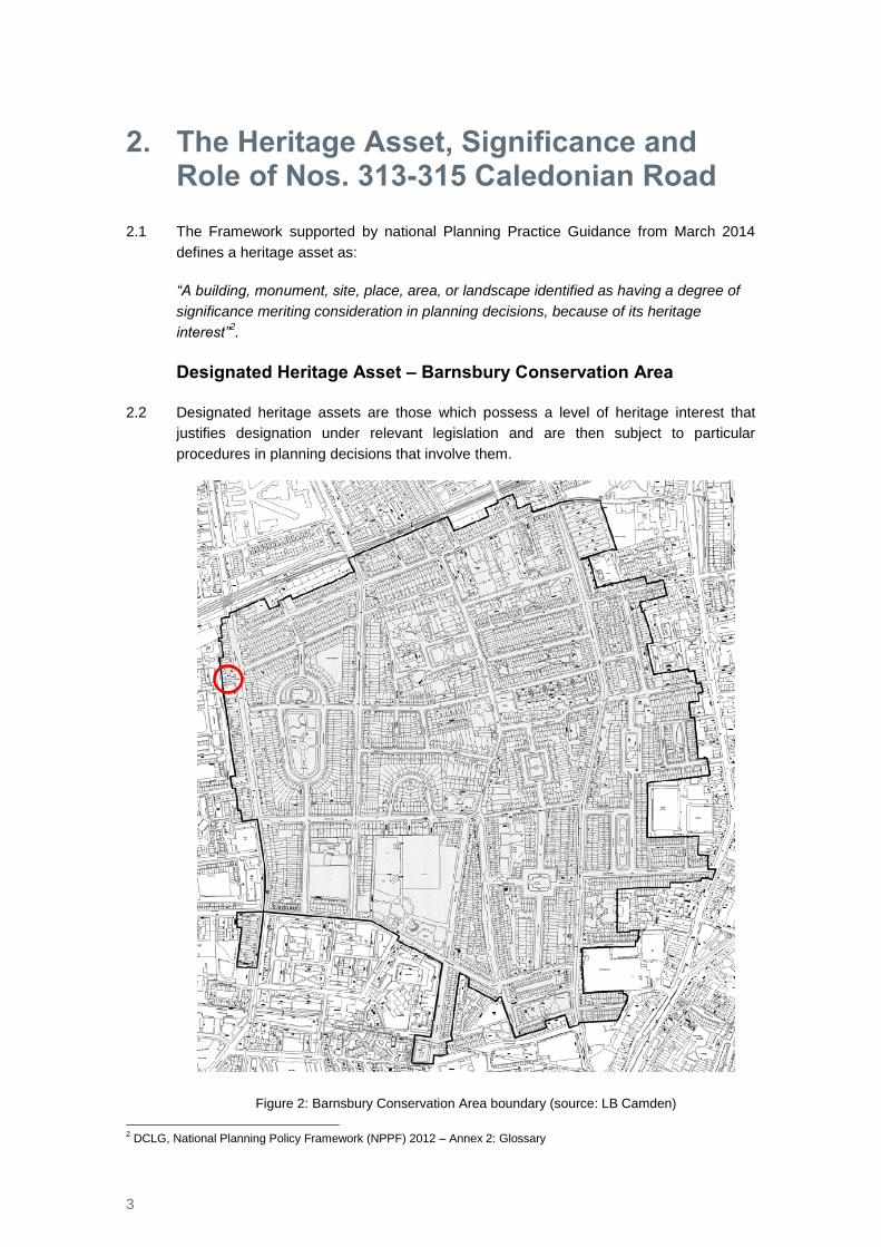
Designated Heritage Asset – Barnsbury Conservation Area
2.2 Designated heritage assets are those which possess a level of heritage interest that
justifies designation under relevant legislation and are then subject to particular
procedures in planning decisions that involve them.
Figure 2: Barnsbury Conservation Area boundary (source: LB Camden)
2 DCLG, National Planning Policy Framework (NPPF) 2012 – Annex 2: Glossary
4
2.3 Nos. 313-315 Caledonian Road lies towards the western edge of the Barnsbury
Conservation Area first designated in April 1969 subsequently reviewed in April 2004.
2.4 For the purposes of Framework policy the conservation area is a designated heritage
asset3 and its significance derives from its special architectural or historic interest the
character or appearance of which it is desirable to preserve or enhance4. The local
planning authority’s Conservation Area Design Guidelines document provides a
description of the area’s character and appearance.
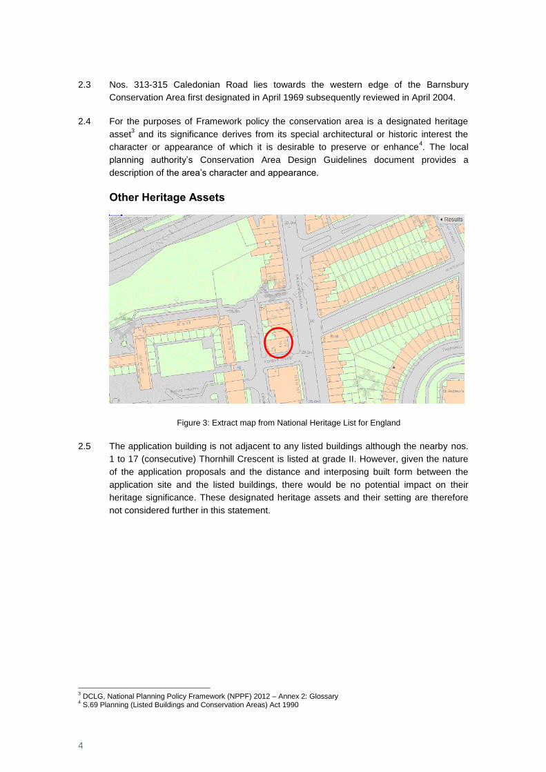
Other Heritage Assets
Figure 3: Extract map from National Heritage List for England
2.5 The application building is not adjacent to any listed buildings although the nearby nos.
1 to 17 (consecutive) Thornhill Crescent is listed at grade II. However, given the nature
of the application proposals and the distance and interposing built form between the
application site and the listed buildings, there would be no potential impact on their
heritage significance. These designated heritage assets and their setting are therefore
not considered further in this statement.
3 DCLG, National Planning Policy Framework (NPPF) 2012 – Annex 2: Glossary
4 S.69 Planning (Listed Buildings and Conservation Areas) Act 1990
5
Significance of Barnsbury Conservation Area
2.6 The Framework defines the significance of a heritage asset as:
“The value of a heritage asset to this and future generations because of its heritage
interest. That interest may be archaeological, architectural, artistic or historic.
Significance derives not only from a heritage asset’s physical presence, but also from its
setting.”5
2.7 As noted above conservation areas are designated on the basis of their special
architectural or historic interest, the character and appearance of which it is desirable to
preserve or enhance.
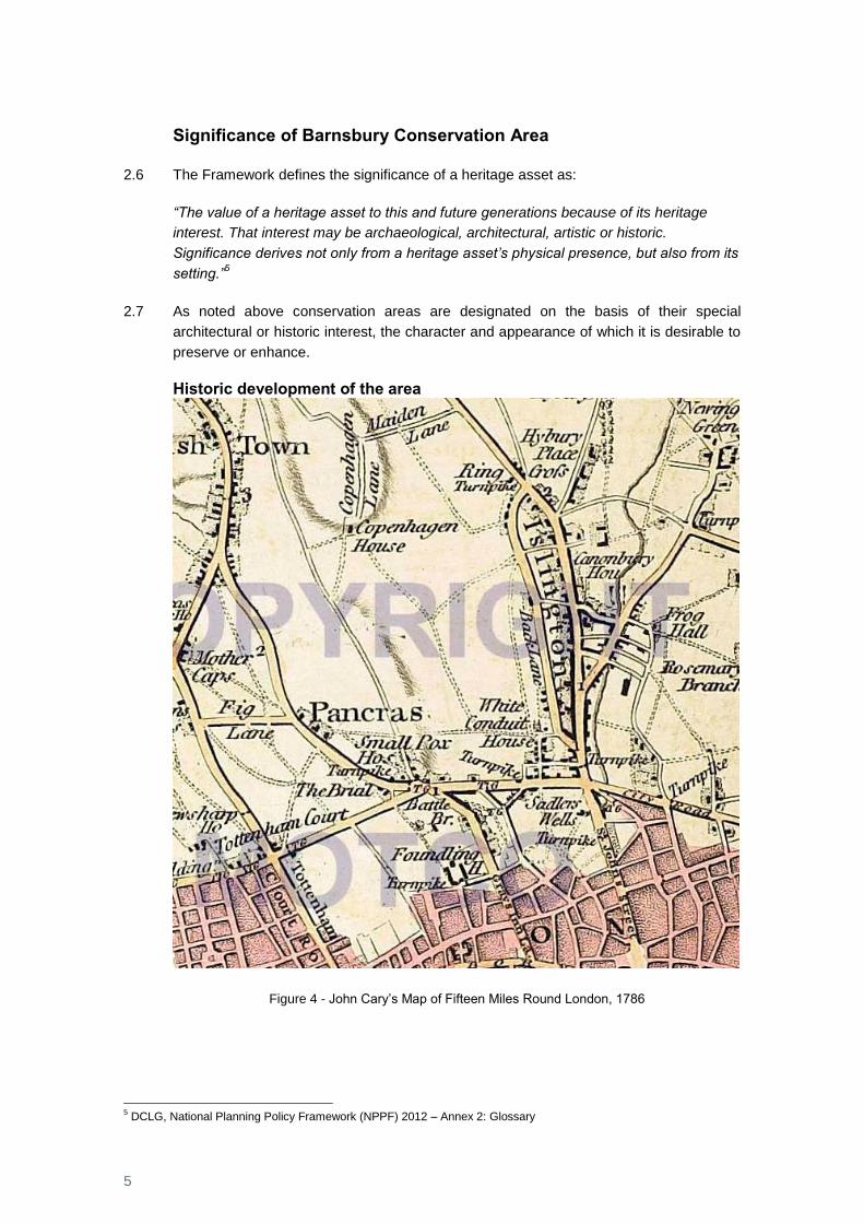
Historic development of the area
Figure 4 - John Cary’s Map of Fifteen Miles Round London, 1786
5 DCLG, National Planning Policy Framework (NPPF) 2012 – Annex 2: Glossary
6
2.8 The growth of Barnsbury and Kings Cross are interlinked6 and the area covering the
whole of the parish west of the settlement along Upper Street and south of the N.L.R.
line was developed early C19th. The only medieval building recorded was Barnsbury
Manor House and its moated site remained until the 19th century.
2.9 Building took place as individual landowners sought to take advantage of a demand
stimulated by the building of Pentonville, in Clerkenwell. By 1817 two streets linking
Back Road with Upper Street had terraced building: Park Street was almost completely
lined by development whilst Barnsbury Street had little building on the north side. The
rest of the area between the two north-south routes was mostly still fields at this time.
2.10 Laycock's large dairy farm was at the north end, a ‘paste-board’ factory had been built
towards the south opposite the later Cloudesley Place, and between Park and
Barnsbury streets lay a large nursery. From the 1820s some of Islington's most
attractive estates were laid out, in a ‘metropolitan style’ – defined by spacious squares
linked by unified terraces with regular facades.
2.11 Building continued in the 1820s on the Barnfield estate under an agreement with Robert
Clarke, with villas on the north side of Barnsbury Park, and two cottages at the east end
of the south side were built in 1821. Park Terrace, fronting Liverpool Road, was built in
1822 stretching both sides of Brooksby Street. In the south-western part of the parish,
George Thornhill had let large areas on brickmaking agreements from 1808 and in 1823
he began making building leases for land south of the canal, including Southampton
(later Calshot) Street and Thornhill Street (later Wynford Road). Land was reserved for
Thornhill Bridge Place north of the canal in 1827, and on the east side of his estate
Gainford Terrace in Richmond Avenue, near Thornhill Road, was built c. 1829. He also
put capital into the making of Caledonian Road in 1826, which furthered growth in the
western part of the parish.
2.12 Agreements for Hemingford Terrace at the south end of Hemingford Road and for land
on the south side of Richmond Avenue at its east end were made by Thornhill in 1838
and 1840 with William Dennis and George Price, partners who also agreed in 1838 with
Henry Rhodes, surveyor for the Coxe family's Denmark estate, to build 10 houses in
Denmark Terrace and 17 in Denmark Street, allowing a plot for the British school in
1840. Dennis and Price also agreed in 1841 for a large plot west of Caledonian Road,
from Copenhagen Street probably to the N.L.R. and in 1841 agreed with Thornhill for
the land between Hemingford and Caledonian roads on either side of Richmond
Avenue, subletting some plots.
2.13 In 1841 the area between Liverpool and Thornhill roads was filling rapidly but the rest of
Barnsbury was largely empty. Cloudesley Square and its adjoining streets were almost
filled, as were Barnsbury Park and neighbouring streets on the Barnfield estate. East of
Liverpool Road only Gibson Square, Theberton Road, and College Cross were filled,
leaving cow layers north of Park Street and some land around the Gibson estate still
open. West of Thornhill Road the area nearest the road and between Richmond Avenue
and Pentonville was nearly all built over, as was a patch between the canal and the
Clerkenwell boundary east of Caledonian Road. West of Caledonian Road what seem to
6 A P Baggs, Diane K Bolton and Patricia E C Croot, 'Islington: Growth, Barnsbury and King's Cross', in A History of the
County of Middlesex: Volume 8, Islington and Stoke Newington Parishes, ed. T F T Baker and C R Elrington (London, 1985), pp. 24-29 http://www.british-history.ac.uk/vch/middx/vol8/pp24-29 [accessed 13 March 2015].
7
have been detached or semi-detached villas and cottages were built in Bemerton, Lyon,
and Gifford streets, and in Buckingham (later Boadicea) Street c. 1845 near the canal,
with terraces between the latter and Caledonian Road, besides a small terrace on the
south side of Randell's Road.
2.14 By the mid-1850s the rest of Barnsbury was almost completely developed. The houses
in the squares in major roads such as Caledonian, Liverpool, Hemingford, and
Richmond roads and in other groups such as Barnsbury Park, Richmond Crescent, and
Albion Grove, were middle-class: substantial three- or four-storeyed terraces with
basements and attics, or detached and semi-detached villas, generally stuccoed with
bay windows. The lesser streets had two- or three-storeyed houses for the lower middle
class and artisans.
2.15 West of Caledonian Road the tile kilns and pollution from industries at Belle Isle in the
early 1850s exasperated householders who had moved there for fresh air and perhaps
accounted for a particularly quick decline. Problems were exacerbated by poor
drainage. Houses in Great and Little William streets suffered from damp basements and
sewage oozing through the walls; farther east an open sewer behind Mountfort Terrace
and Lofting Road complained of in 1848 was still a health hazard in 1853. In Storey
Street piles of builders' rubbish prevented it from being paved for several years after the
houses were occupied. Many of the defects, not unique to Barnsbury, were the result of
quick growth and discouraged from staying those who could afford to move farther
away. The occupants of most of the large terraced houses fronting Caledonian Road,
between Lyon and Copenhagen streets, changed from private residents to tradesmen
and craftsmen between the beginning and middle of the 1850s.
2.16 After the area was built up there were few major changes until the Second World War
although municipal housing began in the area shortly before with the L.C.C.'s Barnsbury
estate near Pentonville, begun in 1936 to relieve serious overcrowding. Bombing during
the Second World War destroyed many houses, particularly north of Copenhagen Street
and west of Caledonian Road, and the borough council began large-scale rebuilding.
The area west of Caledonian Road was nearly all rebuilt over the next 30 years, as the
L.C.C.'s (later G.L.C.'s) Bemerton estate. Caithness House and Orkney House were
built in the early 1960s, followed by blocks at the north and south ends of the estate, the
latter including a fire station and cinema. The estate was completed with blocks near
Stanmore Street behind the Caledonian Road baths, which were also rebuilt.
Beaconsfield Buildings was acquired by the G.L.C. in 1966; the 383 flats, known as one
of the worst slums in the area and nicknamed the Crumbles, were cleared over seven
years.
2.17 From the 1960s further change occurred as young professionals began to renovate the
run-down houses. The Barnsbury Association was formed in 1964 by new middle-class
residents and produced a scheme for closing much of the area to through traffic. The
History of the County of Middlesex7 notes that when the Barnsbury Conservation Area
was created in 1965 such a scheme was introduced at considerable expense and was
bitterly criticized for putting all through traffic along streets that remained working-class.
7 Ibid
8
2.18 In 1983 Barnsbury was noted as retaining many buildings of the earlier 19th century in
unified squares and terraces, making it attractive to current taste. The part between
Milner Square and Thornhill Square was almost all filled with the original houses, or with
open space where they had been cleared, and became a Conservation Area.
Character and Appearance
2.19 The local planning authority’s published Barnsbury Design Guidelines document
(undated) notes that the conservation area is the largest in Islington. Reflecting the
surviving history of the area outlined above, the conservation area is noted to contain
many of the best examples of formal late Georgian/early Victorian residential
development in London. Most notable are the sequences of squares and terraces such
as Lonsdale Square, Gibson Square and Thornhill Square with many comprising mature
trees and well established planting that enhance the surrounding buildings. Overall, the
area is particularly noted to have a rare quality of consistency and completeness.
2.20 The predominant use character is residential with shopping frontages on Liverpool Road
and Caledonian Road proving important local services. The special character and
appearance of the area derives from the survival of C18th and C19th century buildings,
built with traditional materials.
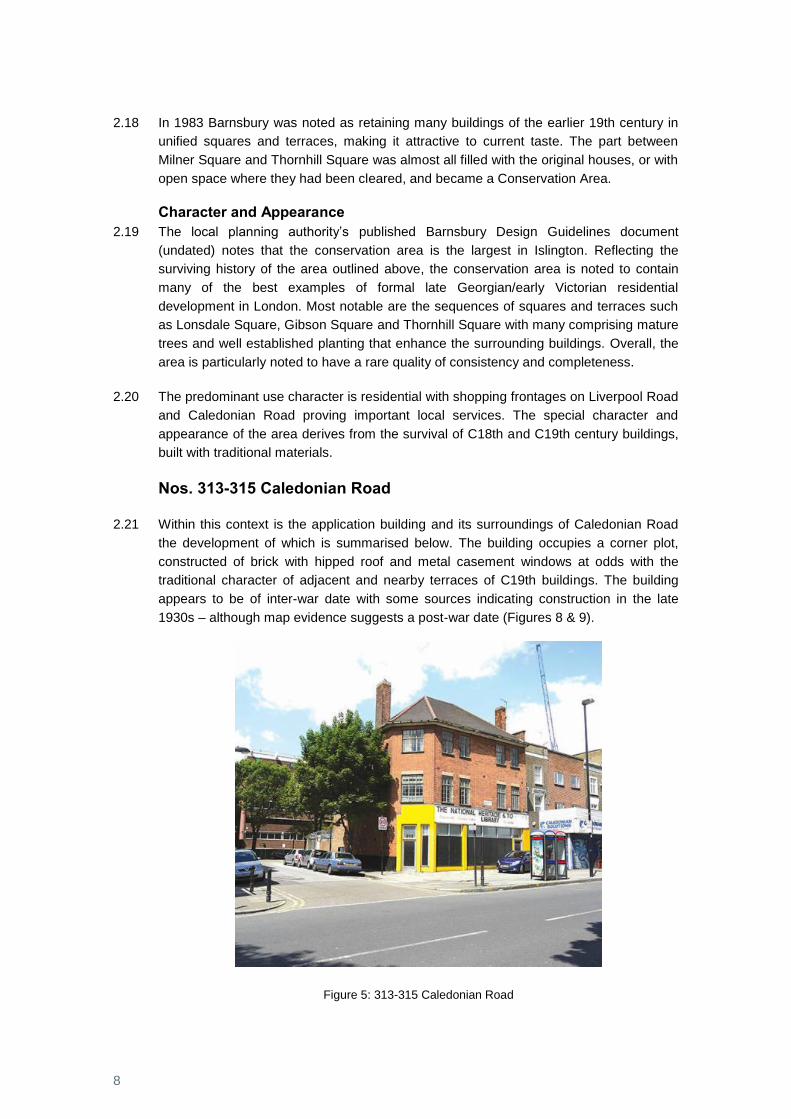
Nos. 313-315 Caledonian Road
2.21 Within this context is the application building and its surroundings of Caledonian Road
the development of which is summarised below. The building occupies a corner plot,
constructed of brick with hipped roof and metal casement windows at odds with the
traditional character of adjacent and nearby terraces of C19th buildings. The building
appears to be of inter-war date with some sources indicating construction in the late
1930s – although map evidence suggests a post-war date (Figures 8 & 9).
Figure 5: 313-315 Caledonian Road
9
2.22 Growth in the western part of the parish was stimulated by the building in 1826 of a road
from Holloway Road at Camden Road to King's Cross, but little of it was residential until
the 1840s. First known as Chalk Road it was later named Caledonian Road after the
Royal Caledonian asylum, built in 1827-8 on a site in Copenhagen fields east of the
road, to replace premises in Hatton Garden. The asylum had been incorporated in 1815
as a charity to support and educate the children of Scottish servicemen killed or
wounded in action and of poor Scots living in London.
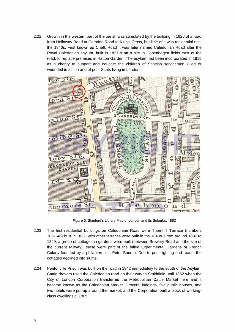
Figure 6: Stanford’s Library Map of London and its Suburbs, 1862
2.23 The first residential buildings on Caledonian Road were Thornhill Terrace (numbers
106-146) built in 1832, with other terraces were built in the 1840s. From around 1837 to
1849, a group of cottages in gardens were built (between Brewery Road and the site of
the current railway); these were part of the failed Experimental Gardens or French
Colony founded by a philanthropist, Peter Baume. Due to poor lighting and roads, the
cottages declined into slums.
2.24 Pentonville Prison was built on the road in 1842 immediately to the south of the Asylum.
Cattle drovers used the Caledonian road on their way to Smithfield until 1852 when the
City of London Corporation transferred the Metropolitan Cattle Market here and it
became known as the Caledonian Market. Drovers' lodgings, five public houses, and
two hotels were put up around the market, and the Corporation built a block of working-
class dwellings c. 1865.
10
2.25 By the time of Stanfords Map (above) in 1862 the area around the application site was
largely developed as a series of terraces along the principle thoroughfares with
crescents and squares set off secondary streets. The application site as this time is part
of the uniform terrace of C19th buildings opposite the junction of Caledonian Road and
Huntingdon Street.
2.26 The layout of the area towards the end of the C19th is also illustrated on the Ordnance
Survey map from 1894-6 (below) clearly showing the regular plot layout of the terraced
buildings. Notably, the application site is comprised as part of a terrace of 7 buildings.
Figure 7: Ordnance Survey Map 1894-6
2.27 During the Second World War the area was subject to bomb damage as illustrated on
the map below. Whilst the terraces to the west of Caledonian Road were damaged the
application site buildings appear undamaged.

11
Figure 8: LCC Bomb Damage Map
2.28 However, the first post war Ordnance Survey map from 1952 illustrates that the two of
the end terrace buildings had been demolished and replaced with the present building
that occupies 313-315 Caledonian Road.
Figure 9: Ordnance Survey Map 1952
2.29 Since this time, the buildings context to the west, outside of the conservation area, has
changed dramatically with the clearance and redevelopment of the C19 terraces for
public sector housing.

12
2.30 As found today the application site building comprises an end of terrace corner building
arranged over basement, ground and two upper floors, constructed of brick with a steep
hipped roof. It contrasts with the adjacent C19th terraced buildings with butterfly roofs.
2.31 At the rear the building has been extended in a number of phases and an uncoordinated
and ad-hoc way and these are visible from Kember Street.
The Cally Plan Supplementary Planning Document (2014)
2.32 As further context the Cally Plan looks at ways in which the commercial section of
Caledonian Road known locally as the ‘Cally’ can be improved. The document is a
Supplementary Planning Document (SPD) and provides greater detail on policies within
the council’s Development Plan Documents (see Planning Statement). The plan area
includes the application building which is identified as a “site to be improved or longer
term development potential” and more specifically to “Bring building back into active use
and remove security fencing”.
13
3. Role of application building in the Significance of the Conservation Area
3.1 The relative role and contribution of nos.313-315 Caledonian Road to the significance,
in terms of character and appearance, of the Barnsbury Conservation Area can be
gauged using Historic England’s suggested checklist8.
Criteria Commentary
Is it the work of a particular architect or designer of regional or local note?
None known
Does it have landmark
quality?
No – the building steps back from the building-line of the
adjacent terrace which has been extended to the back
edge of the pavement.
Does it reflect a substantial
number of other elements
in the conservation area in
age, style, materials, form
or other characteristics?
No – due to its date of construction, architectural form
and appearance the building contrasts with the
traditional architectural and historic character of its
surroundings.
Does it relate to adjacent
designated heritage assets
in age, materials or in any
other historically significant
way?
No – no relationship exists with the nearest designated
heritage assets
Does it contribute positively
to the setting of adjacent
designated heritage
assets?
No – no relationship exists with the nearest designated
heritage assets
Does it contribute to the
quality of recognisable
spaces including exteriors
or open spaces with a
complex of public
No – its recessive building form and architectural form
detracts from the wider townscape form of regular
terraces
8 Historic England Advice Note 1: Conservation Area Designation, Appraisal and Management, 2016, Table 1 Checklist
14
buildings?
Is it associated with a
designed landscape e.g. a
significant wall, terracing or
a garden building?
No
Does it individually, or as
part of a group, illustrate
the development of the
settlement in which it
stands?
Only insofar as the building illustrates the redevelopment
of the C19th terrace in the C20th.
Does it have significant
historic association with
features such as the
historic road layout,
burgage plots, a town park
or a landscape feature?
No – its recessive building form and architectural form
detracts from the wider townscape form of regular
terraces
Does it have historic
associations with local
people or past events?
None are known
Does it reflect the
traditional functional
character or former uses in
the area?
No
Does its use contribute to
the character or
appearance of the area?
Active use of the building would contribute to the
character and appearance of the area.
3.2 Historic England’s guidance suggests that a positive response to one or more of the
questions may indicate that the building makes a positive contribution. In these terms
the building as found today, does not make a positive contribution to the significance of
the conservation area, appearing at odds with the more historic form of the C19th
terraces that otherwise characterise the conservation area and the building’s immediate
surroundings.

15
3.3 As highlighted in the Cally Plan SPD (see paragraph 2.32 above) the building is also
noted as one that will benefit from being brought back into active use in order to improve
the site and its contribution to the local environment.
16
4. Local Views
Local policy background
4.1 Development Management Plan (DMP) ‘Policy DM2.4: Protected views’ identifies the
local views that Islington Council will ‘protect and enhance’ and states that:
“Redevelopment of buildings that currently adversely impact on the local or strategic
view are required to enhance the view and the ability to appreciate the landmark within
the views, and not infringe on any part of the defined view.”
4.2 The accompanying policy text states that new development should enhance the view
and not provide any adverse impacts on it. Details of the location and termination of the
local views viewing corridors are given in Appendix 1 of the DPD. The council is
producing management plans for all local views.
4.3 Policy DM2.1 sets out the council’s design objectives and further supports Policy DM2.4;
stating for a development proposal to be acceptable it is required to not result in an
unacceptable adverse impact on views of local landmarks.
4.4 The application site falls within the identified view corridor to local views LV4: View from
Archway Road and LV5: View from Archway Bridge, as illustrated on Figure 10 below.
Figure 10: Plan illustrating the view corridor of LV4 and LV5
LV4: View from Archway Road
4.5 LV4 is taken from along the eastern footpath of Archway Road looking towards St
Paul’s, as shown in Figure 11. The application site falls within the middle ground of the
view.
17
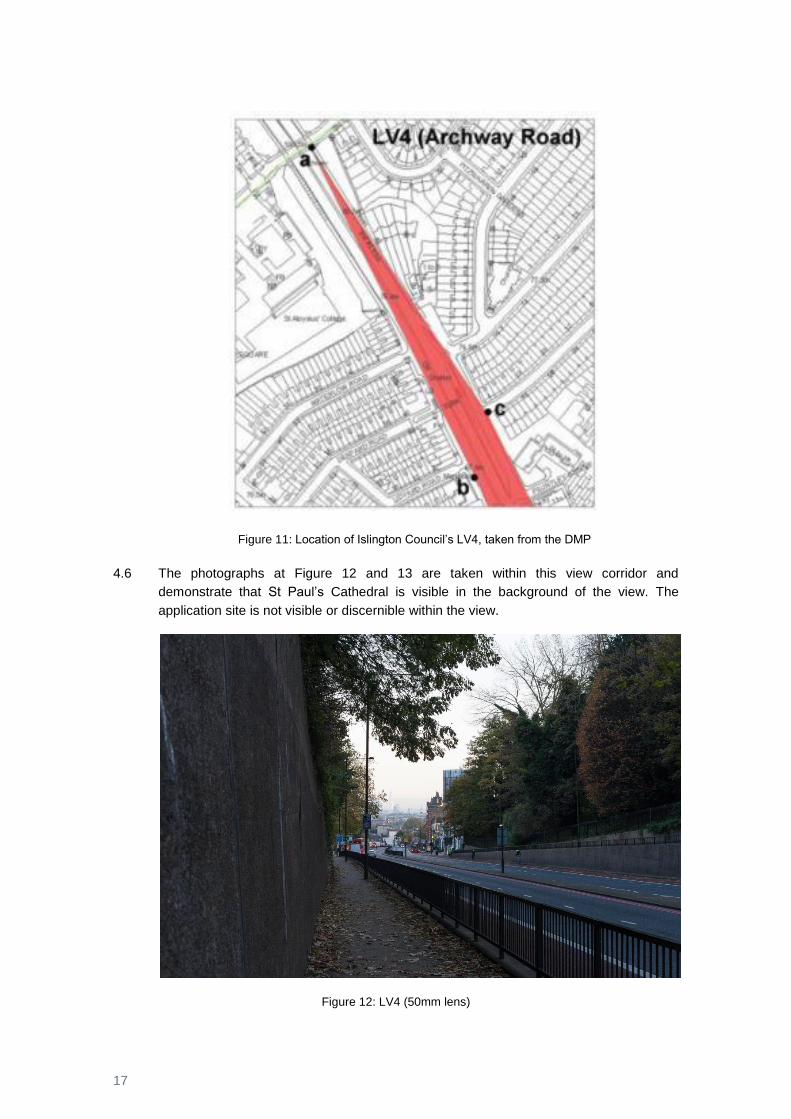
Figure 11: Location of Islington Council’s LV4, taken from the DMP
4.6 The photographs at Figure 12 and 13 are taken within this view corridor and
demonstrate that St Paul’s Cathedral is visible in the background of the view. The
application site is not visible or discernible within the view.
Figure 12: LV4 (50mm lens)
18
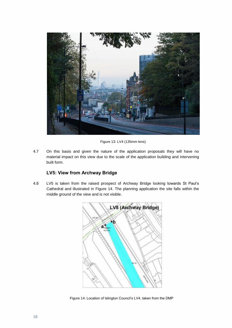
Figure 13: LV4 (135mm lens)
4.7 On this basis and given the nature of the application proposals they will have no
material impact on this view due to the scale of the application building and intervening
built form.
LV5: View from Archway Bridge
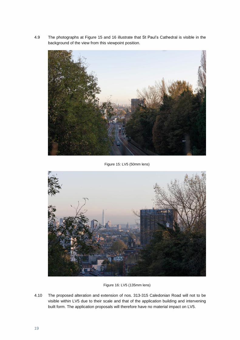
4.8 LV5 is taken from the raised prospect of Archway Bridge looking towards St Paul’s
Cathedral and illustrated in Figure 14. The planning application the site falls within the
middle ground of the view and is not visible.
Figure 14: Location of Islington Council’s LV4, taken from the DMP
19
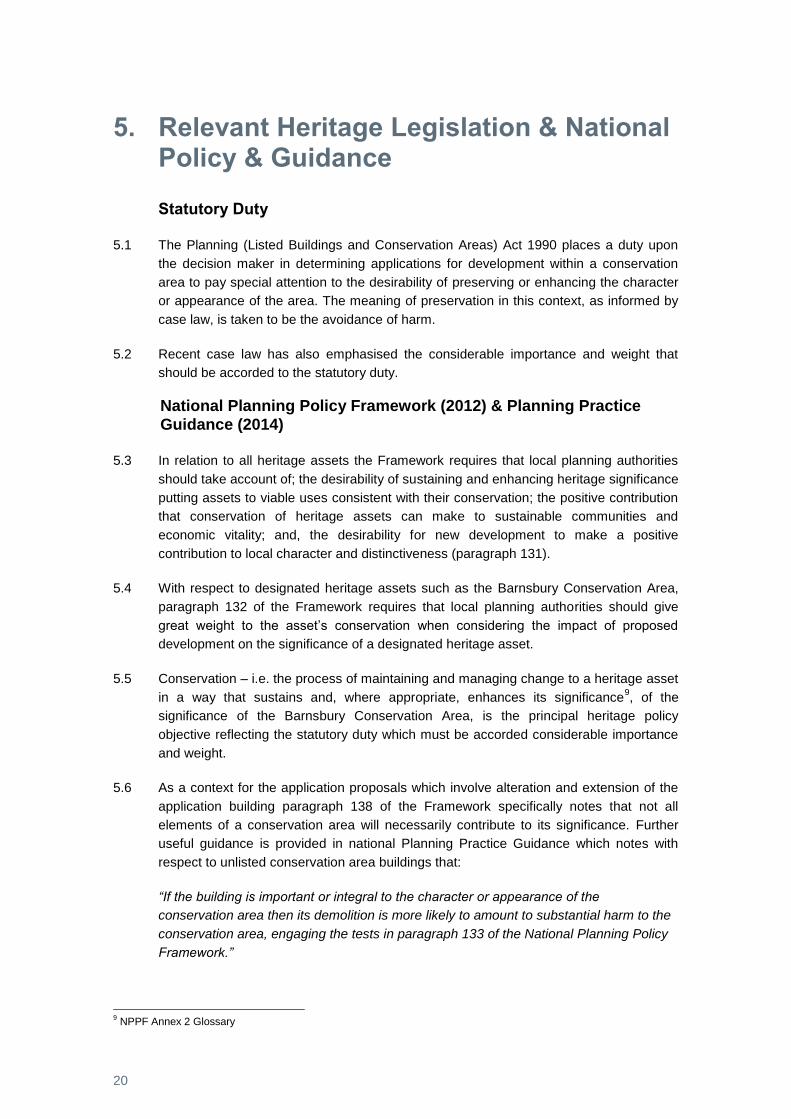
4.9 The photographs at Figure 15 and 16 illustrate that St Paul’s Cathedral is visible in the
background of the view from this viewpoint position.
Figure 15: LV5 (50mm lens)
Figure 16: LV5 (135mm lens)
4.10 The proposed alteration and extension of nos. 313-315 Caledonian Road will not to be
visible within LV5 due to their scale and that of the application building and intervening
built form. The application proposals will therefore have no material impact on LV5.
20
5. Relevant Heritage Legislation & National Policy & Guidance
Statutory Duty
5.1 The Planning (Listed Buildings and Conservation Areas) Act 1990 places a duty upon
the decision maker in determining applications for development within a conservation
area to pay special attention to the desirability of preserving or enhancing the character
or appearance of the area. The meaning of preservation in this context, as informed by
case law, is taken to be the avoidance of harm.
5.2 Recent case law has also emphasised the considerable importance and weight that
should be accorded to the statutory duty.
National Planning Policy Framework (2012) & Planning Practice Guidance (2014)
5.3 In relation to all heritage assets the Framework requires that local planning authorities
should take account of; the desirability of sustaining and enhancing heritage significance
putting assets to viable uses consistent with their conservation; the positive contribution
that conservation of heritage assets can make to sustainable communities and
economic vitality; and, the desirability for new development to make a positive
contribution to local character and distinctiveness (paragraph 131).
5.4 With respect to designated heritage assets such as the Barnsbury Conservation Area,
paragraph 132 of the Framework requires that local planning authorities should give
great weight to the asset’s conservation when considering the impact of proposed
development on the significance of a designated heritage asset.
5.5 Conservation – i.e. the process of maintaining and managing change to a heritage asset
in a way that sustains and, where appropriate, enhances its significance9, of the
significance of the Barnsbury Conservation Area, is the principal heritage policy
objective reflecting the statutory duty which must be accorded considerable importance
and weight.
5.6 As a context for the application proposals which involve alteration and extension of the
application building paragraph 138 of the Framework specifically notes that not all
elements of a conservation area will necessarily contribute to its significance. Further
useful guidance is provided in national Planning Practice Guidance which notes with
respect to unlisted conservation area buildings that:
“If the building is important or integral to the character or appearance of the
conservation area then its demolition is more likely to amount to substantial harm to the
conservation area, engaging the tests in paragraph 133 of the National Planning Policy
Framework.”
9 NPPF Annex 2 Glossary
21
5.7 With respect to new development, paragraph 137 of the Framework requires that local
planning authorities look for opportunities for new development within a conservation
area to enhance or better reveal their significance. The application proposals provide
such an opportunity to meet this policy objective.
5.8 Historic England’s best practice advice10
note provides guidance in respect of new
development in the form of design and local distinctiveness, noting that a successful
scheme will be one whose design has taken account of some or all of the following
characteristics of the surroundings, where appropriate:
• The history of the place
• The relationship of the proposal to its specific site
• The significance of nearby assets and the contribution of their setting, recognising
that this is a dynamic concept
• The general character and distinctiveness of the area in its widest sense,
including the general character of local buildings, spaces, public realm and the
landscape, the grain of the surroundings, which includes, for example the street
pattern and plot size
• The size and density of the proposal related to that of the existing and
neighbouring uses
• Landmarks and other built or landscape features which are key to a sense of
place
• The diversity or uniformity in style, construction, materials, colour, detailing,
decoration and period of existing buildings and spaces
• The topography
• Views into, through and from the site and its surroundings
• Landscape design
• The current and historic uses in the area and the urban grain
• The quality of the materials
5.9 New development which takes account of these characteristics will contribute to the
significance of the conservation area.
10
Historic England, Historic Environment Good Practice Advice in Planning: 2 - Managing Significance in Decision-Taking in the Historic Environment, 2015
22
6. Impact Assessment
Introduction
6.1 The impact on locally identified views subject to local policy is considered in section 4
above where it is concluded there will be no material impact.
6.2 The relevant designated heritage asset has been identified, its significance assessed
and the relative contribution of the application site and building to that significance
reviewed in light of prevailing heritage legislation and national policy and guidance. This
provides the proper basis for assessing the impact of the application proposals on
heritage significance.
6.3 It is evident that the existing application building does not make a positive contribution to
the prevailing character and appearance of the conservation area and that opportunity
exists to improve its appearance and form – and hence its relative contribution to
significance.
Application Proposals
6.4 The application proposals involve the removal of the existing series of ad-hoc rear
ground and first floor extensions and access stairs and their replacement with new
three-storey rear extension with accommodation in the roof. The building as a whole will
be refurbished and brought back into active use and the shopfront will be refurbished.
6.5 Full details of the scheme are provided in the architect’s Design and Access Statement
and the associated planning application drawings.
Alteration and Extension
Figure 17: Application proposals
23
6.6 The application proposals seek to extend the existing building in a more architecturally
coherent form adopting a contemporary, but contextual architectural style employing
traditional materials and finishes.
6.7 The design of the replacement building has been closely informed by study of the
prevailing characteristics of the conservation area as set out in the architect’s Design
and Access Statement.
6.8 The height and mass of the proposed rear extension aligns with the existing return flank
of the building whilst accommodating a recessed ‘break’ to differentiate between new
and old and, in terms of height sits below the existing eaves line. The new extension will
address and enclose Kember Street as an improvement to the present arrangement of
uncoordinated extensions whilst appearing subservient to the principal building facing
Caledonian Road.
6.9 The new extension will comprise a brick ground floor or ‘plinth’ with light grey rendered
upper floors with flat roof and pv arrays. The rear elevation of the existing building will
otherwise be altered to incorporate new fenestration with glass balustrades below.
Accommodation contained within the existing roof form will be lit by new rooflights set
within the plane of the roofslope.
6.10 The traditional elements of the existing shopfront will be refurbished in traditional
materials to a high standard of finish meeting the objectives of local policy.
6.11 With respect to the criteria suggested by relevant best practice advice11
, with regard to
new development and design in context, the application proposals have taken account
of the following characteristics of the surroundings:
1. The history of the place.
The proposed development reflects the historic development of the Site and wider
townscape area. The design of the replacement building has been closely informed
by study of the prevailing characteristics of the conservation area as set out in the
architect’s Design and Access Statement.
2. The relationship of the proposal to its specific site.
The application extend the existing building in a more architecturally coherent form
adopting a contemporary, but contextual architectural style employing traditional
materials and finishes.
3. The size and density of the proposal related to that of the existing and neighbouring
uses.
The proposed development is consistent with the scale and density of this part of
the conservation area.
11
Historic England, Historic Environment Good Practice Advice in Planning: 2 - Managing Significance in Decision-Taking in the Historic Environment, 2015

24
4. The significance of nearby assets and the contribution of their setting, recognising
that this is a dynamic concept.
The design of the building has been informed by a study of the significance of the
conservation area taking account of the contrasting architectural character and later
date of the application building, but nevertheless seeking to draw its characteristics
whilst evolving a contemporary design solution.
5. The general character and distinctiveness of the area in its widest sense, including
the general character of local buildings, spaces, public realm and the landscape, the
grain of the surroundings, which includes, for example the street pattern and plot
size.
The general character of adjacent and nearby buildings in the conservation area has
influenced and been reflected in the design, insofar as relevant to the host building
which it itself in contrast with that character.
6. Landmarks and other built or landscape features which are key to a sense of place.
The significance of the conservation area derives more from homogeneity and
commonality of building form rather than landmark buildings or features. The design
of the application proposals has been influenced by these characteristics rather than
seeking to establish a landmark feature.
7. The diversity or uniformity in style, construction, materials, colour, detailing,
decoration and period of existing buildings and spaces.
The uniformity of height, scale and mass has influenced the design of the proposals
whilst allowing for interpretation of traditional detailing and decoration in a
contemporary manner. Refurbishment of the shopfront will enhance the street
scene.
8. The topography.
The design reflects and respects the prevailing topography, layout and urban grain
of the conservation area.
9. Views into and from the site and its surroundings.
The design has taken account of the location of local townscape views and the site’s
location within the local views corridor where there will be no material impact.
10. Landscape design.
The application proposals offer the opportunity to improve the front forecourt to the
building.
25
11. The current and historic uses in the area and the urban grain.
The application proposals take the opportunity to return the site to predominantly
private residential use with commercial at ground floor to reflect the prevailing land-
use characteristics of the conservation area.
12. The quality of the materials.
The new extension will comprise a brick ground floor or ‘plinth’ with light grey
rendered upper floors with flat roof and pv arrays. The rear elevation of the existing
building will otherwise be altered to incorporate new fenestration with glass
balustrades below. Accommodation contained within the existing roof form will be lit
by new rooflights set within the plane of the roofslope. The traditional elements of
the existing shopfront will be refurbished in traditional materials to a high standard of
finish meeting the objectives of local policy
6.12 The design of the new building has taken account of the contextual characteristics of the
layout and appearance of built form in the conservation area whilst allowing for a
contemporary interpretation of the differing characteristics of the host building.
6.13 In these terms the application proposals will sustain and enhance the significance of the
conservation area and make a positive contribution to local character and
distinctiveness – meeting the objective of Framework paragraph 131. The proposals will
conserve (i.e. the process of maintaining and managing change in a way that sustains
and where appropriate enhances significance) the significance of the designated
heritage asset – meeting the objective of Framework paragraph 132. Further, the
proposals take the opportunity to enhance character and appearance and better reveal
the significance of the conservation area through considered design – meeting the
objective of Framework paragraph 137.
6.14 The application proposals will therefore preserve the character and enhance the
appearance of the conservation area and thereby meet the objective of the duty of the
1990 Act.
26
7. Summary and Conclusions
7.1 In this document the relevant designated heritage asset has been identified, its
significance assessed and the relative contribution of the application site and building to
that significance reviewed in light of prevailing heritage legislation and national policy
and guidance. This has provided a proper basis for assessing the impact of the
application proposals on heritage significance.
7.2 The impact of the application proposals on locally identified views in light of local policy
has been assessed with regard to visual impact from the identified viewpoint locations. It
is concluded that the proposals will have no material impact on LV 4 and LV 5.
7.3 The significance of the designated heritage asset that comprises the Barnsbury
Conservation Area relates to its character and appearance deriving from mid to late
C19th development of terraces and square. In this context the application building, given
its later date and differing architectural style does not make a positive contribution to
significance. The rear of the building is comprised of a series of extensions which
detract from the buildings form and the appearance of this part of the conservation area.
7.4 Opportunity therefore exists for alterations and extension of the building that preserve or
enhance the character or appearance of the conservation area or in Framework terms
potentially to enhance of better reveal significance.
Alteration and Extension
7.5 The design of the replacement building has been closely informed by study of the
prevailing characteristics of the conservation area and the host building as set out in the
architect’s Design and Access Statement.
7.6 The height and mass of the proposed rear extension aligns with the existing return flank
of the building whilst accommodating a recessed ‘break’ to differentiate between new
and old and, in terms of height sits below the existing eaves line. The new extension will
address and enclose Kember Street as an improvement to the present arrangement of
uncoordinated extensions whilst appearing subservient to the principal building facing
Caledonian Road. Refurbishment of the building and specifically the shopfront will
improve its appearance and enhance its contribution to the local street scene.
7.7 The proposals have taken into account the characteristics of their surroundings and
meet the criteria suggested by best practice advice12
with regard to new development
and design in context.
7.8 The application proposals will therefore sustain and enhance the significance of the
conservation area and make a positive contribution to local character and
distinctiveness – meeting the objective of NPPF paragraph 131. The proposals will
conserve (i.e. the process of maintaining and managing change in a way that sustains
and where appropriate enhances significance) the significance of the designated
12
Historic England, Historic Environment Good Practice Advice in Planning: 2 - Managing Significance in Decision-
Taking in the Historic Environment, 2015
27
heritage asset – meeting the objective of NPPF paragraph 132. Further, the proposals
take the opportunity to enhance character and appearance and better reveal the
significance of the conservation area through considered design – meeting the objective
of NPPF paragraph 137.
7.9 The application proposals will therefore preserve the character and enhance the
appearance of the conservation area and thereby meet the objective of the duty of the
1990 Act.

Turley
The Charlotte Building
17 Gresse Street
London
W1T 1QL
T 020 7851 4010