Embed Size (px)
Citation preview
below the final section of Nanga Parbat’s west-southwest ridge. The team established base camp on December 9 at 3,500m and Camp 1 a few days later
at 5,100m. There was far more snow than expected, and the climbers planned a traditional approach, fixing 3,000m of rope and placing well-stocked camps. They established Camp 2 on December 23 at 6,100m in temperatures below –30°C. Wielicki, who turned 57 during the expedition, pushed out ropes to 6,800m in early January, and Przemyslaw Lozinski and Robert Szymczak later established Camp 3 there. However, severe winds prevented further progress, and on January 17 the decision was made to abandon the mountain.
There have been several genuine (i.e. calendar) winter attempts on Nanga Parbat, the best to date by another Polish expedition on the Damir Face. On February 11, 1997, Krzysztof Pankiewiez and Zbigniew Trzmiel retreated just 250m below the summit with severe frostbite.
Lindsay Griffin, Mountain INFO, CLIMB Magazine
Deosai Plains ski crossing. Thomas Niederlein, Norbert Trommler, and I arrived in Pakistan in mid-March, with plans to circumnavigate Nanga Parbat on skis, crossing the Shontar Pass into Kashmir and the Barai Pass toward Chilas.
Just before donning our skis, we were stopped by the army at Rattu in the Astore Valley. Despite the fact that we had a permit to enter the Pakistan-controlled sector of Kashmir, permission issued by the Kashmir Tourist Department, the army stopped us and warned us not to try traveling illegally; they would inform their check posts close to the border of our existence. Too bad!
We changed our plans to try a crossing of the Deosai Plains (east of Nanga Parbat, south of the Indus) from Astore toward Skardu. We would have to do so without a map, without any prior knowledge of the area, but with a rough idea of the route to take. An old jeep took us into the valley leading to Chilam until the snow was 30cm deep. From that point, at an altitude of ca 2,600m, we skied. We didn’t use pulks but carried 20kg rucksacks, which got 700 grams lighter each day.
That afternoon we skied along the snow-covered road for 16 km. The locals were friendly and invited us into their houses for the night. However, worried about catching fleas, we preferred to camp. The next day we traveled another three kilometers to Chilam, at 3,400m, where we had to pay a four-dollar fee to enter the Deosai National Park. Here we went into the wilderness.
It’s hard to imagine how people live here in winter. Snow closes the road by the end of October and does not clear till the start of April. In early spring there is more than a meter of snow, and some of the villagers move around on ski.
From Chilam our route climbed steadily to 4,300m Chhachor Pass. In summer there is a jeep road, but in winter it is a great mountain area, with nice peaks that would be suitable to climb on ski. We didn’t, because we had no idea how long it would take to get to Skardu and hur-ried on our way. From the pass the descent to Sheosar Lake was easy but too gentle for skiing fun. On the subsequent four days we crossed the Deosai Plains, at an average altitude of 4,100m. We didn’t follow the summer track, close to the rivers, but made a more interesting route by crossing ridges and saddles, resulting in at least two fantastic powder runs. Crossing rivers was not a prob-lem, because the entire Deosai Plains were covered by two meters of snow, creating solid bridges. The temperature varied from below -20°C on clear nights to about 0°C on cloudy days. Half the time we were able to collect fresh water by digging deep holes through the snow.
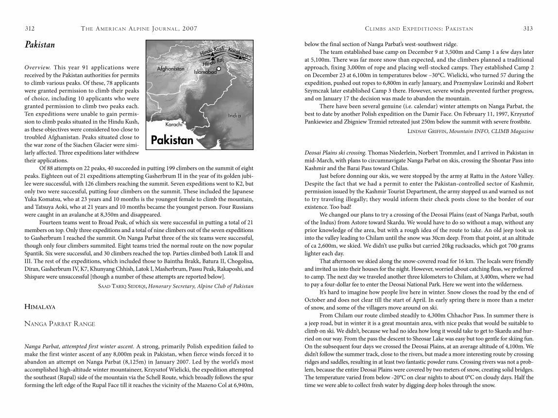
Pakistan
Overview. This year 91 applications were received by the Pakistan authorities for permits to climb various peaks. Of these, 78 applicants were granted permission to climb their peaks of choice, including 10 applicants who were granted permission to climb two peaks each. Ten expeditions were unable to gain permis-sion to climb peaks situated in the Hindu Kush, as these objectives were considered too close to troubled Afghanistan. Peaks situated close to the war zone of the Siachen Glacier were simi-larly affected. Three expeditions later withdrew their applications.
Of 88 attempts on 22 peaks, 40 succeeded in putting 199 climbers on the summit of eight peaks. Eighteen out of 21 expeditions attempting Gasherbrum II in the year of its golden jubi-lee were successful, with 126 climbers reaching the summit. Seven expeditions went to K2, but only two were successful, putting four climbers on the summit. These included the Japanese Yuka Komatsu, who at 23 years and 10 months is the youngest female to climb the mountain, and Tatsuya Aoki, who at 21 years and 10 months became the youngest person. Four Russians were caught in an avalanche at 8,350m and disappeared.
Fourteen teams went to Broad Peak, of which six were successful in putting a total of 21 members on top. Only three expeditions and a total of nine climbers out of the seven expeditions to Gasherbrum I reached the summit. On Nanga Parbat three of the six teams were successful, though only four climbers summited. Eight teams tried the normal route on the now popular Spantik. Six were successful, and 30 climbers reached the top. Parties climbed both Latok II and III. The rest of the expeditions, which included those to Baintha Brakk, Batura II, Chogolisa, Diran, Gasherbrum IV, K7, Khunyang Chhish, Latok I, Masherbrum, Passu Peak, Rakaposhi, and Shispare were unsuccessful [though a number of these attempts are reported below].
saad Tariq siddiqi, Honorary Secretary, Alpine Club of Pakistan
Himalaya
NaNga Parbat raNge
Nanga Parbat, attempted first winter ascent. A strong, primarily Polish expedition failed to make the first winter ascent of any 8,000m peak in Pakistan, when fierce winds forced it to abandon an attempt on Nanga Parbat (8,125m) in January 2007. Led by the world’s most accomplished high-altitude winter mountaineer, Krzysztof Wielicki, the expedition attempted the southeast (Rupal) side of the mountain via the Schell Route, which broadly follows the spur forming the left edge of the Rupal Face till it reaches the vicinity of the Mazeno Col at 6,940m,
th e am e r i c a N al P i N e Jo u r Na l , 2007312 cl i m b s a N d ex P e d i t i o N s : Pa k i s ta N 313
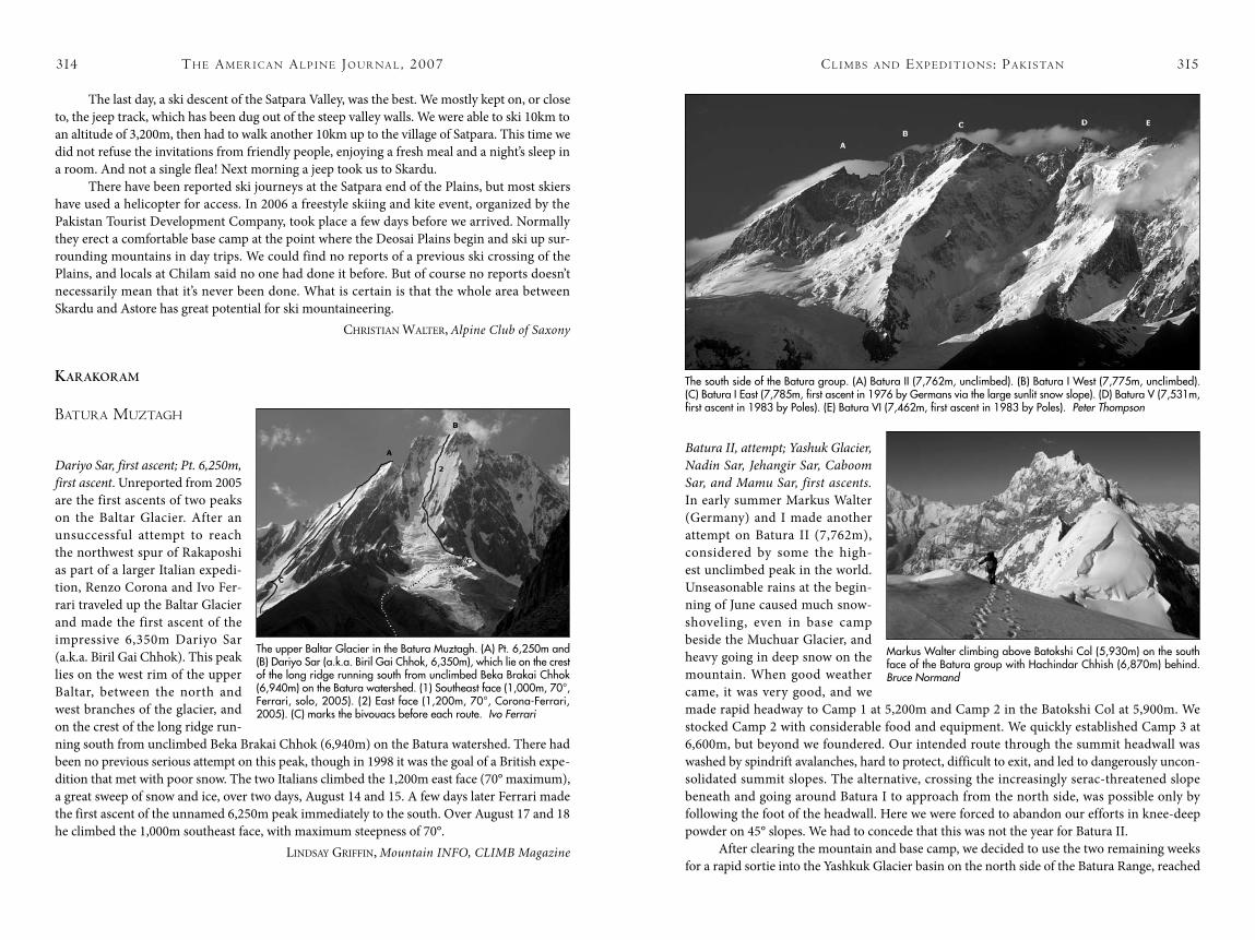
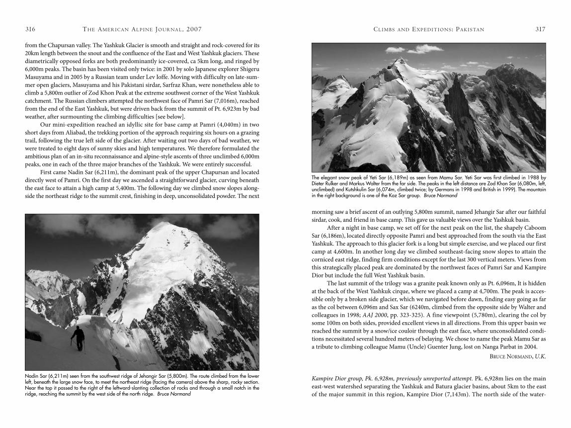
Batura II, attempt; Yashuk Glacier, Nadin Sar, Jehangir Sar, Caboom Sar, and Mamu Sar, first ascents. In early summer Markus Walter (Germany) and I made another attempt on Batura II (7,762m), considered by some the high-est unclimbed peak in the world. Unseasonable rains at the begin-ning of June caused much snow-shoveling, even in base camp beside the Muchuar Glacier, and heavy going in deep snow on the mountain. When good weather came, it was very good, and we made rapid headway to Camp 1 at 5,200m and Camp 2 in the Batokshi Col at 5,900m. We stocked Camp 2 with considerable food and equipment. We quickly established Camp 3 at 6,600m, but beyond we foundered. Our intended route through the summit headwall was washed by spindrift avalanches, hard to protect, difficult to exit, and led to dangerously uncon-solidated summit slopes. The alternative, crossing the increasingly serac-threatened slope beneath and going around Batura I to approach from the north side, was possible only by following the foot of the headwall. Here we were forced to abandon our efforts in knee-deep powder on 45° slopes. We had to concede that this was not the year for Batura II.
After clearing the mountain and base camp, we decided to use the two remaining weeks for a rapid sortie into the Yashkuk Glacier basin on the north side of the Batura Range, reached
th e am e r i c a N al P i N e Jo u r Na l , 2007314
The last day, a ski descent of the Satpara Valley, was the best. We mostly kept on, or close to, the jeep track, which has been dug out of the steep valley walls. We were able to ski 10km to an altitude of 3,200m, then had to walk another 10km up to the village of Satpara. This time we did not refuse the invitations from friendly people, enjoying a fresh meal and a night’s sleep in a room. And not a single flea! Next morning a jeep took us to Skardu.
There have been reported ski journeys at the Satpara end of the Plains, but most skiers have used a helicopter for access. In 2006 a freestyle skiing and kite event, organized by the Pakistan Tourist Development Company, took place a few days before we arrived. Normally they erect a comfortable base camp at the point where the Deosai Plains begin and ski up sur-rounding mountains in day trips. We could find no reports of a previous ski crossing of the Plains, and locals at Chilam said no one had done it before. But of course no reports doesn’t necessarily mean that it’s never been done. What is certain is that the whole area between Skardu and Astore has great potential for ski mountaineering.
ChrisTian WaLTer, Alpine Club of Saxony
KaraKoram
batura muztagh
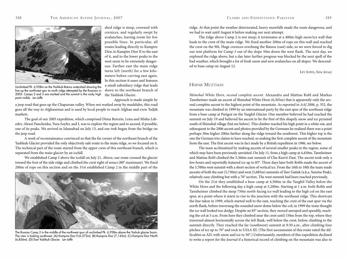
Dariyo Sar, first ascent; Pt. 6,250m, first ascent. Unreported from 2005 are the first ascents of two peaks on the Baltar Glacier. After an unsuccessful attempt to reach the northwest spur of Rakaposhi as part of a larger Italian expedi-tion, Renzo Corona and Ivo Fer-rari traveled up the Baltar Glacier and made the first ascent of the impressive 6,350m Dariyo Sar (a.k.a. Biril Gai Chhok). This peak lies on the west rim of the upper Baltar, between the north and west branches of the glacier, and on the crest of the long ridge run-ning south from unclimbed Beka Brakai Chhok (6,940m) on the Batura watershed. There had been no previous serious attempt on this peak, though in 1998 it was the goal of a British expe-dition that met with poor snow. The two Italians climbed the 1,200m east face (70° maximum), a great sweep of snow and ice, over two days, August 14 and 15. A few days later Ferrari made the first ascent of the unnamed 6,250m peak immediately to the south. Over August 17 and 18 he climbed the 1,000m southeast face, with maximum steepness of 70°.
Lindsay Griffin, Mountain INFO, CLIMB Magazine
cl i m b s a N d ex P e d i t i o N s : Pa k i s ta N 315
The upper Baltar Glacier in the Batura Muztagh. (A) Pt. 6,250m and (B) Dariyo Sar (a.k.a. Biril Gai Chhok, 6,350m), which lie on the crest of the long ridge running south from unclimbed Beka Brakai Chhok (6,940m) on the Batura watershed. (1) Southeast face (1,000m, 70°, Ferrari, solo, 2005). (2) East face (1,200m, 70°, Corona-Ferrari, 2005). (C) marks the bivouacs before each route. Ivo Ferrari
Markus Walter climbing above Batokshi Col (5,930m) on the south face of the Batura group with Hachindar Chhish (6,870m) behind. Bruce Normand
The south side of the Batura group. (A) Batura II (7,762m, unclimbed). (B) Batura I West (7,775m, unclimbed). (C) Batura I East (7,785m, first ascent in 1976 by Germans via the large sunlit snow slope). (D) Batura V (7,531m, first ascent in 1983 by Poles). (E) Batura VI (7,462m, first ascent in 1983 by Poles). Peter Thompson
cl i m b s a N d ex P e d i t i o N s : Pa k i s ta N 317
morning saw a brief ascent of an outlying 5,800m summit, named Jehangir Sar after our faithful sirdar, cook, and friend in base camp. This gave us valuable views over the Yashkuk basin.
After a night in base camp, we set off for the next peak on the list, the shapely Caboom Sar (6,186m), located directly opposite Pamri and best approached from the south via the East Yashkuk. The approach to this glacier fork is a long but simple exercise, and we placed our first camp at 4,600m. In another long day we climbed southeast-facing snow slopes to attain the corniced east ridge, finding firm conditions except for the last 300 vertical meters. Views from this strategically placed peak are dominated by the northwest faces of Pamri Sar and Kampire Dior but include the full West Yashkuk basin.
The last summit of the trilogy was a granite peak known only as Pt. 6,096m, It is hidden at the back of the West Yashkuk cirque, where we placed a camp at 4,700m. The peak is acces-sible only by a broken side glacier, which we navigated before dawn, finding easy going as far as the col between 6,096m and Sax Sar (6240m, climbed from the opposite side by Walter and colleagues in 1998; AAJ 2000, pp. 323-325). A fine viewpoint (5,780m), clearing the col by some 100m on both sides, provided excellent views in all directions. From this upper basin we reached the summit by a snow/ice couloir through the east face, where unconsolidated condi-tions necessitated several hundred meters of belaying. We chose to name the peak Mamu Sar as a tribute to climbing colleague Mamu (Uncle) Guenter Jung, lost on Nanga Parbat in 2004.
BruCe normand, U.K.
Kampire Dior group, Pk. 6,928m, previously unreported attempt. Pk. 6,928m lies on the main east-west watershed separating the Yashkuk and Batura glacier basins, about 5km to the east of the major summit in this region, Kampire Dior (7,143m). The north side of the water-
th e am e r i c a N al P i N e Jo u r Na l , 2007316
from the Chapursan valley. The Yashkuk Glacier is smooth and straight and rock-covered for its 20km length between the snout and the confluence of the East and West Yashkuk glaciers. These diametrically opposed forks are both predominantly ice-covered, ca 5km long, and ringed by 6,000m peaks. The basin has been visited only twice: in 2001 by solo Japanese explorer Shigeru Masuyama and in 2005 by a Russian team under Lev Ioffe. Moving with difficulty on late-sum-mer open glaciers, Masuyama and his Pakistani sirdar, Sarfraz Khan, were nonetheless able to climb a 5,800m outlier of Zod Khon Peak at the extreme southwest corner of the West Yashkuk catchment. The Russian climbers attempted the northwest face of Pamri Sar (7,016m), reached from the end of the East Yashkuk, but were driven back from the summit of Pt. 6,923m by bad weather, after surmounting the climbing difficulties [see below].
Our mini-expedition reached an idyllic site for base camp at Pamri (4,040m) in two short days from Aliabad, the trekking portion of the approach requiring six hours on a grazing trail, following the true left side of the glacier. After waiting out two days of bad weather, we were treated to eight days of sunny skies and high temperatures. We therefore formulated the ambitious plan of an in-situ reconnaissance and alpine-style ascents of three unclimbed 6,000m peaks, one in each of the three major branches of the Yashkuk. We were entirely successful.
First came Nadin Sar (6,211m), the dominant peak of the upper Chapursan and located directly west of Pamri. On the first day we ascended a straightforward glacier, curving beneath the east face to attain a high camp at 5,400m. The following day we climbed snow slopes along-side the northeast ridge to the summit crest, finishing in deep, unconsolidated powder. The next
Nadin Sar (6,211m) seen from the southwest ridge of Jehangir Sar (5,800m). The route climbed from the lower left, beneath the large snow face, to meet the northeast ridge (facing the camera) above the sharp, rocky section. Near the top it passed to the right of the leftward-slanting collection of rocks and through a small notch in the ridge, reaching the summit by the west side of the north ridge. Bruce Normand
The elegant snow peak of Yeti Sar (6,189m) as seen from Mamu Sar. Yeti Sar was first climbed in 1988 by Dieter Rulker and Markus Walter from the far side. The peaks in the left distance are Zod Khon Sar (6,080m, left, unclimbed) and Kutshkulin Sar (6,074m, climbed twice; by Germans in 1998 and British in 1999). The mountain in the right background is one of the Koz Sar group. Bruce Normand
cl i m b s a N d ex P e d i t i o N s : Pa k i s ta N 319
ridge. At that point the weather deteriorated, heavy snowfalls made the route dangerous, and we had to wait until August 6 before making our next attempt.
The ridge above Camp 2 is not steep; it terminates at a 400m-high snow/ice wall that leads to the crest of the main ridge. We fixed another 200m of rope on this wall and reached the crest on the 9th. Huge cornices overhung the Batura (east) side, so we were forced to dig our tent platform for Camp 3 out of the slope 50m down the west flank. The next day, we explored the ridge above, but a day later further progress was blocked by the next spell of the bad weather, which brought a lot of fresh snow and new avalanches on all slopes. We descend-ed to base camp on August 12.
Lev ioffe, New Jersey
hisPar muztagh
Shimshal White Horn, second complete ascent. Alexandra and Mattias Robl and Markus Tannheimer made an ascent of Shimshal White Horn (6,303m) that is apparently only the sec-ond complete ascent to the highest point of the mountain. As reported in AAJ 2006, p. 352, the mountain was climbed in 1999 by an international party by the east spur of the northeast ridge from a base camp at Parigoz on the Yazghil Glacier. One member believed he had reached the summit on July 19 and believed his ascent to be the first of this shapely snow and ice pyramid south of Shimshal village (but see below). This climber reached his high point in a white out, and subsequent to the 2006 ascent and photos provided by the Germans he realized there was a point perhaps 30m higher 200m farther along the ridge toward the southwest. This higher top is the one the German trio claims to have reached, so making the first complete ascent of the mountain from the east. The first ascent was in fact made by a British expedition in 1986, see below.
The team acclimatized by making ascents of several smaller peaks in the region, some of which may have been previously unvisited. On July 11, from a high camp at 4,450m, Tannheimer and Mattias Robl climbed the 5,366m east summit of Chu Kurrti Dast. The ascent took only a few hours and reportedly featured ice up to 85°. Three days later both Robls made the ascent of the 5,700m west summit with a short section of vertical ice. From the 16th to 18th the team made ascents of both the east (5,730m) and west (5,685m) summits of Yeer Gattak (a.k.a. Sunrise Peak), relatively easy climbing but with a 70° section. The west summit had been reached previously.
On the 21st they established a base camp at 4,500m in the Yazghil Valley below the White Horn and the following day a high camp at 5,200m. Starting at 1 a.m. both Robls and Tannheimer climbed the steep 750m north-facing ice wall leading to the high col on the east spur, at a point where it starts to rise to the junction with the northeast ridge. This shortcuts the line taken in 1999, which started well to the east, reaching the crest of the east spur via the north flank, before traversing the rounded snow dome below the col; in 1999 the team thought the ice wall looked too dodgy. Despite an 85° section, they moved unroped and speedily, reach-ing the col at 5 a.m. From here they climbed near the crest until 150m from the top, where they traversed almost horizontally across the left flank, well below the crest, before climbing to the summit directly. They reached the far (southwest) summit at 9:30 a.m., after climbing four pitches of ice up to 70° and rock to UIAA III. (The first ascensionist of this route rated the dif-ficulties as AD, with snow and ice to 50°.) Unfortunately, members of this expedition declined to write a report for the Journal if a historical record of climbing on the mountain was also to
th e am e r i c a N al P i N e Jo u r Na l , 2007318
shed ridge is steep, crowned with cornices, and regularly swept by avalanches, leaving room for few possible lines. In particular, all routes leading directly to Kampire Dior, to Kampire Dior II to the east of it, and to the lower peaks to the west seem to be extremely danger-ous. Farther east the main ridge turns left (north) for a few kilo-meters before curving east again. In this section it eases and features a small subsidiary ridge that leads down to the northeast branch of the Yashkuk Glacier.
Approach is made simple by a jeep road that goes up the Chapursan valley. When not washed away by mudslides, this road goes all the way to Afghanistan and is used by local people to reach Afghan and even Tadjik markets.
The goal of our 2005 expedition, which comprised Dima Berezin, Lena and Misha Leb-edev, Alexei Panchenko, Yura Soyfer, and I, was to explore the region and to ascend, if possible, one of its peaks. We arrived in Islamabad on July 13, and our trek began from the bridge on the jeep road.
A week of reconnaissance convinced us that the far corner of the northeast branch of the Yashkuk Glacier provided the only objectively safe route to the main ridge, so we focused on it. The technical part of the route started from the upper cwm of this northeast branch, which is separated from the main glacier by an icefall.
We established Camp I above the icefall on July 21. Above, our route crossed the glacier toward the foot of the side ridge and climbed the crest right of seracs (80° maximum). We fixed 200m of rope on this section and on the 31st established Camp 2 in the middle part of the
Unclimbed Pk. 6,928m on the Yashkuk-Batura watershed showing the line up the northwest spur to north ridge attempted by the Russians in 2005. Camps 2 and 3 are marked and the summit is the rocky high point visible. Lev Ioffe
The Russian Camp 2 in the middle of the northwest spur of unclimbed Pk. 6,928m above the Yashuk glacier basin. The view is looking southwest. (A) Kampire Dior II (6,572m). (B) Kampire Dior (7,143m). (C) Kampire Dior North (6,856m). (D) East Yashkuk Glacier. Lev Ioffe
cl i m b s a N d ex P e d i t i o N s : Pa k i s ta N 321
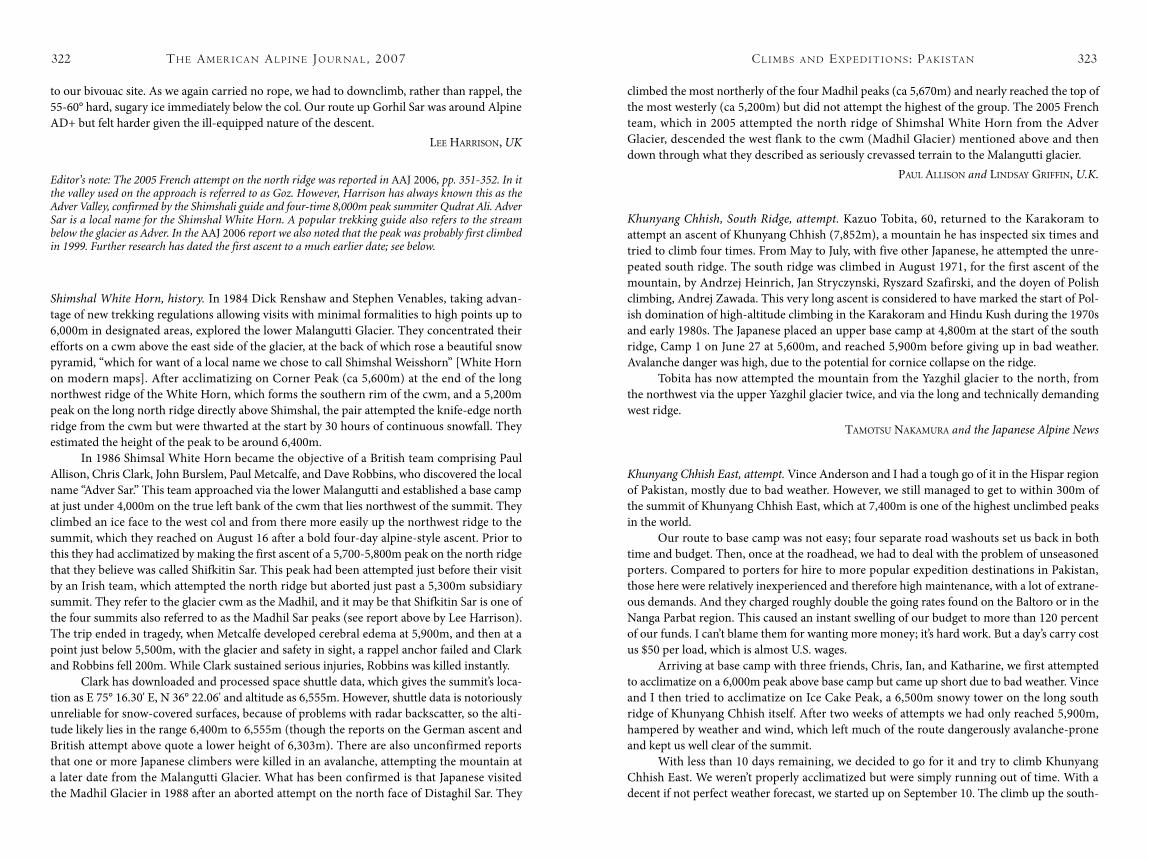
retreated. However, there was time for a quick ascent [possibly the first, but see entry below on Shifki-tin Sar] of Madhil Sar (ca 5,700m), a small summit 100m above and northwest of the col.
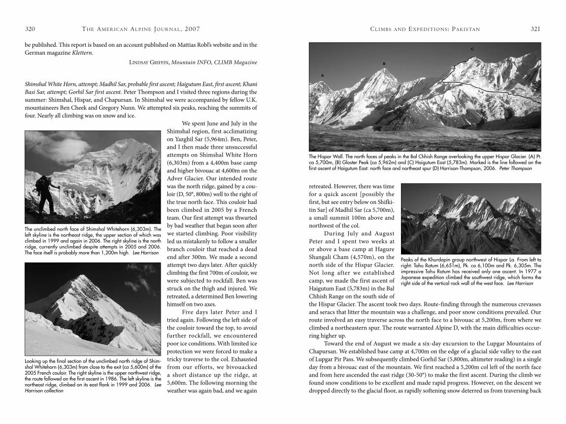
During July and August Peter and I spent two weeks at or above a base camp at Hagure Shangali Cham (4,570m), on the north side of the Hispar Glacier. Not long after we established camp, we made the first ascent of Haigutum East (5,783m) in the Bal Chhish Range on the south side of the Hispar Glacier. The ascent took two days. Route-finding through the numerous crevasses and seracs that litter the mountain was a challenge, and poor snow conditions prevailed. Our route involved an easy traverse across the north face to a bivouac at 5,200m, from where we climbed a northeastern spur. The route warranted Alpine D, with the main difficulties occur-ring higher up.
Toward the end of August we made a six-day excursion to the Lupgar Mountains of Chapursan. We established base camp at 4,700m on the edge of a glacial side valley to the east of Lupgar Pir Pass. We subsequently climbed Gorhil Sar (5,800m, altimeter reading) in a single day from a bivouac east of the mountain. We first reached a 5,200m col left of the north face and from here ascended the east ridge (30-50°) to make the first ascent. During the climb we found snow conditions to be excellent and made rapid progress. However, on the descent we dropped directly to the glacial floor, as rapidly softening snow deterred us from traversing back
th e am e r i c a N al P i N e Jo u r Na l , 2007320
be published. This report is based on an account published on Mattias Robl’s website and in the German magazine Klettern.
Lindsay Griffin, Mountain INFO, CLIMB Magazine
Shimshal White Horn, attempt; Madhil Sar, probable first ascent; Haigutum East, first ascent; Khani Basi Sar, attempt; Gorhil Sar first ascent. Peter Thompson and I visited three regions during the summer: Shimshal, Hispar, and Chapursan. In Shimshal we were accompanied by fellow U.K. mountaineers Ben Cheek and Gregory Nunn. We attempted six peaks, reaching the summits of four. Nearly all climbing was on snow and ice.
We spent June and July in the Shimshal region, first acclimatizing on Yazghil Sar (5,964m). Ben, Peter, and I then made three unsuccessful attempts on Shimshal White Horn (6,303m) from a 4,400m base camp and higher bivouac at 4,600m on the Adver Glacier. Our intended route was the north ridge, gained by a cou-loir (D, 50°, 800m) well to the right of the true north face. This couloir had been climbed in 2005 by a French team. Our first attempt was thwarted by bad weather that began soon after we started climbing. Poor visibility led us mistakenly to follow a smaller branch couloir that reached a dead end after 300m. We made a second attempt two days later. After quickly climbing the first 700m of couloir, we were subjected to rockfall. Ben was struck on the thigh and injured. We retreated, a determined Ben lowering himself on two axes.
Five days later Peter and I tried again. Following the left side of the couloir toward the top, to avoid further rockfall, we encountered poor ice conditions. With limited ice protection we were forced to make a tricky traverse to the col. Exhausted from our efforts, we bivouacked a short distance up the ridge, at 5,600m. The following morning the weather was again bad, and we again
The unclimbed north face of Shimshal Whitehorn (6,303m). The left skyline is the northeast ridge, the upper section of which was climbed in 1999 and again in 2006. The right skyline is the north ridge, currently unclimbed despite attempts in 2005 and 2006. The face itself is probably more than 1,200m high. Lee Harrison
Looking up the final section of the unclimbed north ridge of Shim-shal Whitehorn (6,303m) from close to the exit (ca 5,600m) of the 2005 French couloir. The right skyline is the upper northwest ridge, the route followed on the first ascent in 1986. The left skyline is the northeast ridge, climbed on its east flank in 1999 and 2006. Lee Harrison collection
Peaks of the Khurdopin group northwest of Hispar La. From left to right: Tahu Ratum (6,651m), Pk. ca 6,100m and Pk. 6,305m. The impressive Tahu Ratum has received only one ascent. In 1977 a Japanese expedition climbed the southwest ridge, which forms the right side of the vertical rock wall of the west face. Lee Harrison
The Hispar Wall. The north faces of peaks in the Bal Chhish Range overlooking the upper Hispar Glacier. (A) Pt. ca 5,700m, (B) Gloster Peak (ca 5,962m) and (C) Haigutum East (5,783m). Marked is the line followed on the first ascent of Haigutum East: north face and northeast spur (D) Harrison-Thompson, 2006. Peter Thompson
cl i m b s a N d ex P e d i t i o N s : Pa k i s ta N 323
climbed the most northerly of the four Madhil peaks (ca 5,670m) and nearly reached the top of the most westerly (ca 5,200m) but did not attempt the highest of the group. The 2005 French team, which in 2005 attempted the north ridge of Shimshal White Horn from the Adver Glacier, descended the west flank to the cwm (Madhil Glacier) mentioned above and then down through what they described as seriously crevassed terrain to the Malangutti glacier.
PauL aLLison and Lindsay Griffin, U.K.
Khunyang Chhish, South Ridge, attempt. Kazuo Tobita, 60, returned to the Karakoram to attempt an ascent of Khunyang Chhish (7,852m), a mountain he has inspected six times and tried to climb four times. From May to July, with five other Japanese, he attempted the unre-peated south ridge. The south ridge was climbed in August 1971, for the first ascent of the mountain, by Andrzej Heinrich, Jan Stryczynski, Ryszard Szafirski, and the doyen of Polish climbing, Andrej Zawada. This very long ascent is considered to have marked the start of Pol-ish domination of high-altitude climbing in the Karakoram and Hindu Kush during the 1970s and early 1980s. The Japanese placed an upper base camp at 4,800m at the start of the south ridge, Camp 1 on June 27 at 5,600m, and reached 5,900m before giving up in bad weather. Avalanche danger was high, due to the potential for cornice collapse on the ridge.
Tobita has now attempted the mountain from the Yazghil glacier to the north, from the northwest via the upper Yazghil glacier twice, and via the long and technically demanding west ridge.
TamoTsu nakamura and the Japanese Alpine News
Khunyang Chhish East, attempt. Vince Anderson and I had a tough go of it in the Hispar region of Pakistan, mostly due to bad weather. However, we still managed to get to within 300m of the summit of Khunyang Chhish East, which at 7,400m is one of the highest unclimbed peaks in the world.
Our route to base camp was not easy; four separate road washouts set us back in both time and budget. Then, once at the roadhead, we had to deal with the problem of unseasoned porters. Compared to porters for hire to more popular expedition destinations in Pakistan, those here were relatively inexperienced and therefore high maintenance, with a lot of extrane-ous demands. And they charged roughly double the going rates found on the Baltoro or in the Nanga Parbat region. This caused an instant swelling of our budget to more than 120 percent of our funds. I can’t blame them for wanting more money; it’s hard work. But a day’s carry cost us $50 per load, which is almost U.S. wages.
Arriving at base camp with three friends, Chris, Ian, and Katharine, we first attempted to acclimatize on a 6,000m peak above base camp but came up short due to bad weather. Vince and I then tried to acclimatize on Ice Cake Peak, a 6,500m snowy tower on the long south ridge of Khunyang Chhish itself. After two weeks of attempts we had only reached 5,900m, hampered by weather and wind, which left much of the route dangerously avalanche-prone and kept us well clear of the summit.
With less than 10 days remaining, we decided to go for it and try to climb Khunyang Chhish East. We weren’t properly acclimatized but were simply running out of time. With a decent if not perfect weather forecast, we started up on September 10. The climb up the south-
th e am e r i c a N al P i N e Jo u r Na l , 2007322
to our bivouac site. As we again carried no rope, we had to downclimb, rather than rappel, the 55-60° hard, sugary ice immediately below the col. Our route up Gorhil Sar was around Alpine AD+ but felt harder given the ill-equipped nature of the descent.
Lee harrison, UK
Editor’s note: The 2005 French attempt on the north ridge was reported in AAJ 2006, pp. 351-352. In it the valley used on the approach is referred to as Goz. However, Harrison has always known this as the Adver Valley, confirmed by the Shimshali guide and four-time 8,000m peak summiter Qudrat Ali. Adver Sar is a local name for the Shimshal White Horn. A popular trekking guide also refers to the stream below the glacier as Adver. In the AAJ 2006 report we also noted that the peak was probably first climbed in 1999. Further research has dated the first ascent to a much earlier date; see below.
Shimshal White Horn, history. In 1984 Dick Renshaw and Stephen Venables, taking advan-tage of new trekking regulations allowing visits with minimal formalities to high points up to 6,000m in designated areas, explored the lower Malangutti Glacier. They concentrated their efforts on a cwm above the east side of the glacier, at the back of which rose a beautiful snow pyramid, “which for want of a local name we chose to call Shimshal Weisshorn” [White Horn on modern maps]. After acclimatizing on Corner Peak (ca 5,600m) at the end of the long northwest ridge of the White Horn, which forms the southern rim of the cwm, and a 5,200m peak on the long north ridge directly above Shimshal, the pair attempted the knife-edge north ridge from the cwm but were thwarted at the start by 30 hours of continuous snowfall. They estimated the height of the peak to be around 6,400m.
In 1986 Shimsal White Horn became the objective of a British team comprising Paul Allison, Chris Clark, John Burslem, Paul Metcalfe, and Dave Robbins, who discovered the local name “Adver Sar.” This team approached via the lower Malangutti and established a base camp at just under 4,000m on the true left bank of the cwm that lies northwest of the summit. They climbed an ice face to the west col and from there more easily up the northwest ridge to the summit, which they reached on August 16 after a bold four-day alpine-style ascent. Prior to this they had acclimatized by making the first ascent of a 5,700-5,800m peak on the north ridge that they believe was called Shifkitin Sar. This peak had been attempted just before their visit by an Irish team, which attempted the north ridge but aborted just past a 5,300m subsidiary summit. They refer to the glacier cwm as the Madhil, and it may be that Shifkitin Sar is one of the four summits also referred to as the Madhil Sar peaks (see report above by Lee Harrison). The trip ended in tragedy, when Metcalfe developed cerebral edema at 5,900m, and then at a point just below 5,500m, with the glacier and safety in sight, a rappel anchor failed and Clark and Robbins fell 200m. While Clark sustained serious injuries, Robbins was killed instantly.
Clark has downloaded and processed space shuttle data, which gives the summit’s loca-tion as E 75° 16.30' E, N 36° 22.06' and altitude as 6,555m. However, shuttle data is notoriously unreliable for snow-covered surfaces, because of problems with radar backscatter, so the alti-tude likely lies in the range 6,400m to 6,555m (though the reports on the German ascent and British attempt above quote a lower height of 6,303m). There are also unconfirmed reports that one or more Japanese climbers were killed in an avalanche, attempting the mountain at a later date from the Malangutti Glacier. What has been confirmed is that Japanese visited the Madhil Glacier in 1988 after an aborted attempt on the north face of Distaghil Sar. They
cl i m b s a N d ex P e d i t i o N s : Pa k i s ta N 325
west face went relatively smoothly, as all but one pitch was easy, or at least easier than I thought it would be. Although an earlier attempt had reported climbing up to M7 midway up the face, we had better (colder) conditions and were able to simul-climb or solo on good firm ice and névé the entire way to our second bivouac. At the M7 section we went a bit farther left and found 60-80° ice, eight to 10cm thick. The next day the most difficult climbing of the ascent came immediately: one pitch of M6+, followed by another of M6, and then progressively easier ground as we climbed toward our third and highest bivouac. We had surpassed the previous team’s high point and made our top bivouac 600m below the summit. The weather was clear but windy.
The next morning was brilliantly clear but incredibly cold, and we headed out as soon as the sun came up. We took six hours to climb the next 300m, reaching the top of the face at around 2 p.m. Here we were stopped on the crest by a steep step that we could just not avoid. To the right was a massive cornice; to the left was steep, blank rock. Vince tried for some time to figure a way to climb directly up the edge between snow and rock, but with no real gear, bad rock, strong, cold winds, and tired bodies, we turned around. In hindsight we agreed that lack of acclimatization contributed to the retreat. We were both really cold (and it got colder on the ridge), and I wasn’t able to keep down food or liquid. I have no regrets about turning around, as I have a feeling that had we continued, something bad would have come of it.
The next day we did about 10 rappels to regain our second bivouac. Then it started to snow really hard. After about an hour (of wishful thinking), we called a halt to our descent and
th e am e r i c a N al P i N e Jo u r Na l , 2007324
repitched the tent on the tiny site. A sleepless, stressful bivouac followed. It continued to snow hard all night, and we had to dig ourselves out once per hour. It was the worst bivouac I’ve had since that night on the summit of North Twin a few years ago with Marko Prezelj.
At 5 a.m. it cleared, so we quickly crammed our sodden gear into our packs and started to rappel. It was a good thing, too, because by the time we were stepping off the face eight hours and many, many rappels later, it was starting to snow again.
sTeve house, AAC
Editor’s note: In 2003 an experienced three-man Polish team comprising Janusz Golab, Stanislaw Pie-cuch, and Grzegorz Skorek climbed unroped up the 2,500m southwest face for ca 1,000m, then pitched more sustained ground, Skorek leading a very thin ice/mixed pitch at M7, with little or no protection, to 6,700m. Temperatures were high, snow conditions were bad, and after their third bivouac the weather began to look ominous. They retreated.
Prior to their visit the mountain had been attempted by a 10-man Korean team. Their original aim may have been the south ridge, but they were unable to make inroads, and it appears they turned to the long south ridge of Khunyang Chhish Main, presumably hoping to traverse over or around Khunyang Chhish South to the east summit. They climbed as far as the Ice Cake before retreating.
shuiJerab grouP
Wulio-I-Sar (6,050m), first ascent. Mathieu Paley, a French professional photographer based in Hong Kong, has spent a considerable amount of time in the Karakoram over the last three to four years working for NGOs. He and I are passionate about British exploration in the north-ern areas of the Karakoram (the travels of Younghusband, Conway, Shipton, et al). We are also interested in the history of Shimshal’s remote population. The aim of our two-man trip was to explore the Braldu Valley near the Chinese border and make the first ascent of an easy peak named Wulio-I-Sar (a.k.a. Chikar Sar, 6,050m).
This involved a walk of five days from Shimshal village to our base camp. We reached the spot known as Wulio, which lies below the south face of Wulio-I-Sar, and walked up a narrow valley to the start of the glacier at 5,000m. Here we spent the night under a large boulder on the moraine. The next morning, August 8, we began at 4:30 a.m. We avoided seracs by slant-ing right up the south face to a small col and then up through an easy crevassed area to reach the east ridge. We gained its crest at ca 5,800m and followed it easily to the summit. This was Paley’s first-ever mountain. It took six-and-a-half hours from the moraine and was Alpine F. We had no altimeter and have taken the height from Nelles Map Sheet 2.
For over two weeks we explored the lower reaches of the Braldu Valley and an old salt mine located at place known as Darband, near the Chinese border. The former mining activity may have justified the existence of an old route across the Lukpe La (5,620m), connecting the Braldu to Askole in Baltistan. This Lukpe La (maybe first identified by Younghusband, then Schomberg in 1934) is the fifth pass that was originally identified by early British explorers (after the Turkestan Pass, Saltoro Pass, and West and East Muztagh passes). In a cave we dis-covered a burial site and skeleton, which leads us to believe that this deserted area was formerly inhabited by travelers and salt workers.
Bruno CoLLard, France
Looking up the Pumari Chhish Glacier at (A) Khunyang Chhish South (a.k.a. Tent Peak, ca 7,600m, unclimbed). (B) Khunyang Chhish (7,852m, two ascents). (D) Khunyang Chhish East (7,400m, unclimbed). (E) Pumari Chhish (7,492m, one ascent). (F) Pumari Chhish South (7,350m, unclimbed). (1) is the line attempted by the Americans in 2006 with their bivouacs marked, CI (5,900m), C2 (6,400m), C3 (6,700m), and (H) the high point at 7,100m. The dotted lines show the route taken by the Poles in 2003, where different from the Americans. Their high point was the American C2 at 6,400m. (2) South Ridge. Lee Harrison
cl i m b s a N d ex P e d i t i o N s : Pa k i s ta N 327
on the summit, which we felt was over 6,000m, in light snow. From there we rappelled from a stake. We then downclimbed and rap-pelled from Abalalovs and snow bollards to reach the tent. Three of us began the climb: Fernando Rubio, Iñaki Ruiz Peribañez, and I. However, Rubio stayed in the tent, and only Ruiz and I reached the summit.
The peak we climbed is the one immediately left of Spantik as you contemplate the classic view of the Golden Pillar from the west, so it might be possible that our mountain already has a name. In any case it was super to be climb-ing in a largely unknown area packed with elegant 6,000m summits having no names and no existing routes.
We spent 25 days at or above base camp in July and reached Hispar village by jeep in nine hours from Karimabad. We first traveled to Nagar on a tarmac road, then along difficult tracks and dangerous bridges.
kike de PaBLo, Spain
Editor’s note: At the time the Spanish climbers were unaware of a previous visit by a four-man British expedition. In 1994 Brian Davison, Bill Church, Tony Parks, and Dave Wilkinson reached the Garum-bar Glacier, camped at Uyumrung (4,000m) and at 4,800m on the lower east ridge of what they chris-tened Uyumrung Sar. They inspected the route above to 5,000m, where it got steep, then returned to base camp. Returning a few days later, they avoided the rotten rock step above 5,000m, via a couloir on the left, and camped at 5,700m, before it got too hot. The following day they continued to what appeared to be an impenetrable serac barrier guarding the summit. They made a long traverse left to gain the south ridge, up which they climbed easily to the top. They estimated the altitude of this summit, which lay approximately two kilometers north-northeast of Spantik, as ca 5,900m.
chogoluNgma grouP
Twin Peak I. Previously unreported was a 2005 visit to the Kero-Lungma Glacier by a small British expedition comprising Bill Church, Pete Holden, and Colin Morton. During July and August they planned to explore the northeast branch and climb some of the biggest peaks at its head but were only able to make the probable first ascent of Twin Peak I (ca 5,500m on maps), which they felt was more like 5,800m. On several occasions they were forced to retreat from high camps on Twin Peak II (ca 5,450m) and Pt 6,123m by poor weather and dangerous condi-tions. They warn future expeditions that indicated heights vary from one map to another and rarely agreed with their own findings.
th e am e r i c a N al P i N e Jo u r Na l , 2007326
rakaPoshi raNge
Garumbar Glacier, Uyumrung Sar, second ascent. Four friends and I aimed to explore the Garumbar Glacier, the first tributary to the south of the main Hispar Glacier. We hadn’t seen any pictures of this valley, nor had any information, and were curious about the northeast face of Spantik, which rises from the head of the glacier. Unfortunately, its 3,000m of rocky and, in places, vertical face was threatened by big hanging seracs on every side. So we looked at several neighboring 6,000m peaks and eventually climbed one, which we named Uyum Rum Chhish after the name of the yak pastures with small lakes that lie at the base of the mountain’s east ridge.
Our base camp was situated at 4,000m [Uyumrung], six to eight hours walk from Hispar Village. It was a convenient site, grassy, covered with flowers, and with water flowing down from a collection of towering rock pinnacles. The rock on these 500m vertical walls looked to be sound granite [one of the 300m faces was climbed by a British party at E1/E2; see below], but the same could not be said of our mountain. Rocky outcrops there were composed of a layered and sandy material, unsuitable for protection with pitons and stoppers.
We climbed the east ridge, placing a tent at 5,000m. From there we climbed the moun-tain in a single push, in a 23-hour roundtrip. It wasn’t very difficult, but neither was it easy. Heavy corniced ridges led to domes of deep snow, hidden crevasses, and bergschrunds. The finish led over a complicated cake of seracs, with some technical ice climbing. We arrived
Approaching the summit seracs on the east ridge of Uyumrung Sar (ca 5,900m) during the second ascent. Kike De Pablo
At ca 5,500m on the east ridge of Uyumrung Sar during the second ascent. Below is the Garumbar Glacier, with unnamed and unclimbed peaks forming its eastern rim. Kike De Pablo
cl i m b s a N d ex P e d i t i o N s : Pa k i s ta N 329
bear our weight. Around June 20 we established an advanced base, stocked with 10 days of food and fuel, on the col.
We spent three days on the col resting and acclimatizing. Then, after fixing two ropes above the col, we set out for an alpine-style attempt on the ridge, taking two ropes, four days of food, and no tent. We climbed the 700m rock buttress that forms the first section of the route in one day. It gave excellent free-climbing on beautiful red granite, except for the 10m bolt ladder installed by a previous party. Sustained at 5.7, the hardest sections were around 5.10a and, where it was mixed, M5. Route-finding was easy due to three sets of old fixed ropes and other junk, shamefully left in place on earlier attempts. Above the buttress four rope lengths of ice/mixed led to a long horizontal band of 60° ice. Here we hacked ice from an abandoned portaledge at 6,350m to make a bivouac site. During the next day, in unsettled weather, we traversed right several
hundred meters along the band to a better bivouac site below an overhang.Despite a drop in pressure, the next morning dawned clear, and we set off for a light-
weight push to the summit. A few more insecure pitches along the traverse led to a serac band guarding the upper snowfields. Excellent mixed and overhanging ice climbing led through the barrier to another traverse system (45-50°) leading back toward the south face. Bad weather arrived a little after midday. The westerly wind became increasingly strong, and the summit soon disappeared in cloud. Rationalizing that a night out in a storm at this altitude could prove fatal, we bailed from a height of 6,850m. The next day we arrived back at the col in full-blown storm, having been able to use old anchors from previous trips for most of our rappels. Spin-drift and small avalanches became incessant, and we lost most of a rope. We continued down from the col when the storm briefly subsided and were back in base camp on the 30th.
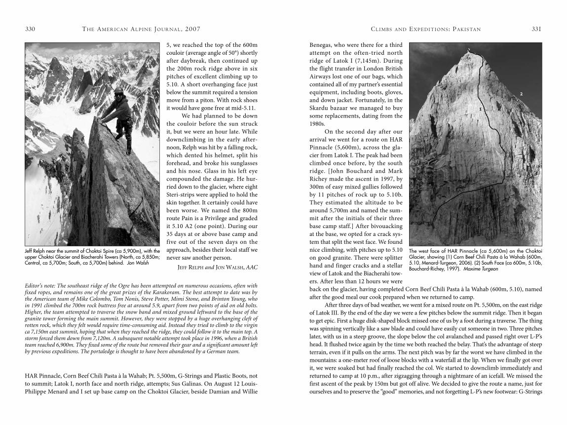
When good weather returned, we had no more than a week left, not enough time for a second attempt. So we tried an attractive nunatak at the head of the glacier; it rose almost 1,000m on its south side and was around 5,900m in altitude. We dubbed it Choktoi Spire and chose a west-facing couloir leading to the southeast ridge. Leaving just after midnight on July
th e am e r i c a N al P i N e Jo u r Na l , 2007328
The Kero-Lungma flows southeast from the Nushak La, an old pass linking the valley to the Hispar Glacier. No peaks appear to have been climbed from the Kero-Lungma before 1996, when the valley was visited by a four-man British expedition that included Bill Church. The British in 1996 climbed three peaks, including Redakh Brakk (ca 6,000m) on the Hispar watershed. [See AAJ 1997, pp. 313-315.]
Lindsay Griffin, Mountain INFO, CLIMB Magazine
PaNmah muztagh
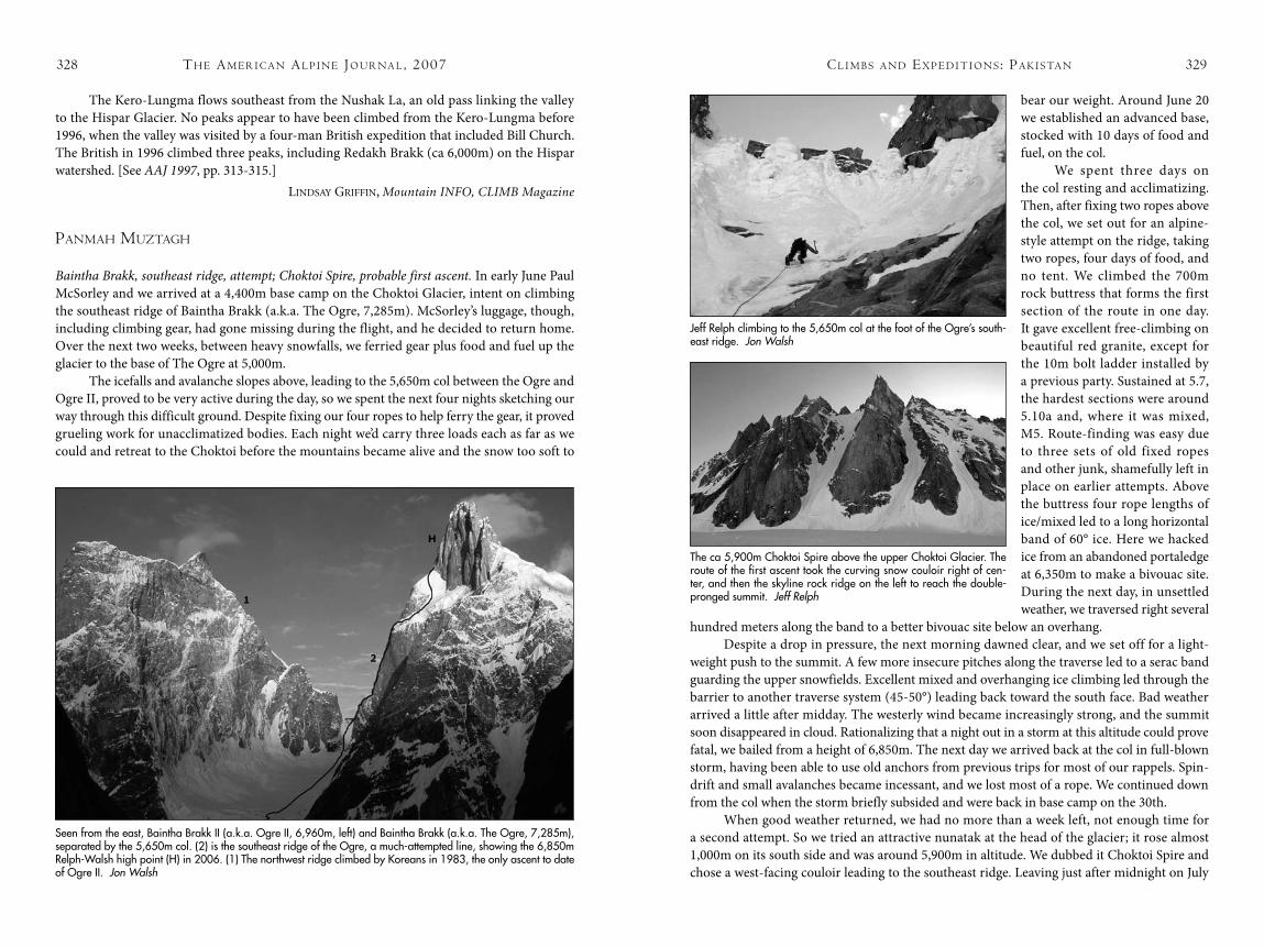
Baintha Brakk, southeast ridge, attempt; Choktoi Spire, probable first ascent. In early June Paul McSorley and we arrived at a 4,400m base camp on the Choktoi Glacier, intent on climbing the southeast ridge of Baintha Brakk (a.k.a. The Ogre, 7,285m). McSorley’s luggage, though, including climbing gear, had gone missing during the flight, and he decided to return home. Over the next two weeks, between heavy snowfalls, we ferried gear plus food and fuel up the glacier to the base of The Ogre at 5,000m.
The icefalls and avalanche slopes above, leading to the 5,650m col between the Ogre and Ogre II, proved to be very active during the day, so we spent the next four nights sketching our way through this difficult ground. Despite fixing our four ropes to help ferry the gear, it proved grueling work for unacclimatized bodies. Each night we’d carry three loads each as far as we could and retreat to the Choktoi before the mountains became alive and the snow too soft to
Jeff Relph climbing to the 5,650m col at the foot of the Ogre’s south-east ridge. Jon Walsh
Seen from the east, Baintha Brakk II (a.k.a. Ogre II, 6,960m, left) and Baintha Brakk (a.k.a. The Ogre, 7,285m), separated by the 5,650m col. (2) is the southeast ridge of the Ogre, a much-attempted line, showing the 6,850m Relph-Walsh high point (H) in 2006. (1) The northwest ridge climbed by Koreans in 1983, the only ascent to date of Ogre II. Jon Walsh
The ca 5,900m Choktoi Spire above the upper Choktoi Glacier. The route of the first ascent took the curving snow couloir right of cen-ter, and then the skyline rock ridge on the left to reach the double-pronged summit. Jeff Relph
330 331
5, we reached the top of the 600m couloir (average angle of 50°) shortly after daybreak, then continued up the 200m rock ridge above in six pitches of excellent climbing up to 5.10. A short overhanging face just below the summit required a tension move from a piton. With rock shoes it would have gone free at mid-5.11.
We had planned to be down the couloir before the sun struck it, but we were an hour late. While downclimbing in the early after-noon, Relph was hit by a falling rock, which dented his helmet, split his forehead, and broke his sunglasses and his nose. Glass in his left eye compounded the damage. He hur-ried down to the glacier, where eight Steri-strips were applied to hold the skin together. It certainly could have been worse. We named the 800m route Pain is a Privilege and graded it 5.10 A2 (one point). During our 35 days at or above base camp and five out of the seven days on the approach, besides their local staff we never saw another person.
Jeff reLPh and Jon WaLsh, AAC
Editor’s note: The southeast ridge of the Ogre has been attempted on numerous occasions, often with fixed ropes, and remains one of the great prizes of the Karakoram. The best attempt to date was by the American team of Mike Colombo, Tom Nonis, Steve Potter, Mimi Stone, and Brinton Young, who in 1991 climbed the 700m rock buttress free at around 5.9, apart from two points of aid on old bolts. Higher, the team attempted to traverse the snow band and mixed ground leftward to the base of the granite tower forming the main summit. However, they were stopped by a huge overhanging cleft of rotten rock, which they felt would require time-consuming aid. Instead they tried to climb to the virgin ca 7,150m east summit, hoping that when they reached the ridge, they could follow it to the main top. A storm forced them down from 7,120m. A subsequent notable attempt took place in 1996, when a British team reached 6,900m. They fixed some of the route but removed their gear and a significant amount left by previous expeditions. The portaledge is thought to have been abandoned by a German team.
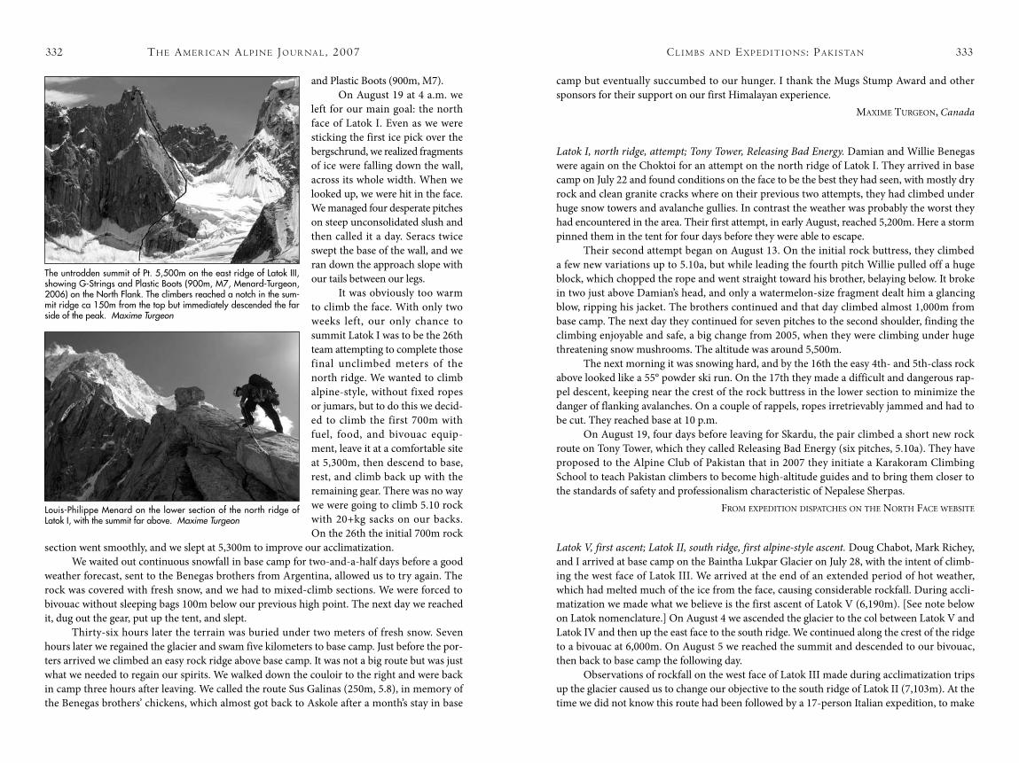
HAR Pinnacle, Corn Beef Chili Pasta à la Wahab; Pt. 5,500m, G-Strings and Plastic Boots, not to summit; Latok I, north face and north ridge, attempts; Sus Galinas. On August 12 Louis-Philippe Menard and I set up base camp on the Choktoi Glacier, beside Damian and Willie
Benegas, who were there for a third attempt on the often-tried north ridge of Latok I (7,145m). During the flight transfer in London British Airways lost one of our bags, which contained all of my partner’s essential equipment, including boots, gloves, and down jacket. Fortunately, in the Skardu bazaar we managed to buy some replacements, dating from the 1980s.
On the second day after our arrival we went for a route on HAR Pinnacle (5,600m), across the gla-cier from Latok I. The peak had been climbed once before, by the south ridge. [John Bouchard and Mark Richey made the ascent in 1997, by 300m of easy mixed gullies followed by 11 pitches of rock up to 5.10b. They estimated the altitude to be around 5,700m and named the sum-mit after the initials of their three base camp staff.] After bivouacking at the base, we opted for a crack sys-tem that split the west face. We found nice climbing, with pitches up to 5.10 on good granite. There were splitter hand and finger cracks and a stellar view of Latok and the Biacherahi tow-ers. After less than 12 hours we were back on the glacier, having completed Corn Beef Chili Pasta à la Wahab (600m, 5.10), named after the good meal our cook prepared when we returned to camp.
After three days of bad weather, we went for a mixed route on Pt. 5,500m, on the east ridge of Latok III. By the end of the day we were a few pitches below the summit ridge. Then it began to get epic. First a huge disk-shaped block missed one of us by a foot during a traverse. The thing was spinning vertically like a saw blade and could have easily cut someone in two. Three pitches later, with us in a steep groove, the slope below the col avalanched and passed right over L-P’s head. It flushed twice again by the time we both reached the belay. That’s the advantage of steep terrain, even if it pulls on the arms. The next pitch was by far the worst we have climbed in the mountains: a one-meter roof of loose blocks with a waterfall at the lip. When we finally got over it, we were soaked but had finally reached the col. We started to downclimb immediately and returned to camp at 10 p.m., after zigzagging through a nightmare of an icefall. We missed the first ascent of the peak by 150m but got off alive. We decided to give the route a name, just for ourselves and to preserve the “good” memories, and not forgetting L-P’s new footwear: G-Strings
cl i m b s a N d ex P e d i t i o N s : Pa k i s ta Nth e am e r i c a N al P i N e Jo u r Na l , 2007
Jeff Relph near the summit of Choktoi Spire (ca 5,900m), with the upper Choktoi Glacier and Biacherahi Towers (North, ca 5,850m; Central, ca 5,700m; South, ca 5,700m) behind. Jon Walsh
The west face of HAR Pinnacle (ca 5,600m) on the Choktoi Glacier, showing (1) Corn Beef Chili Pasta à la Wahab (600m, 5.10, Menard-Turgeon, 2006). (2) South Face (ca 600m, 5.10b, Bouchard-Richey, 1997). Maxime Turgeon
332 333
and Plastic Boots (900m, M7).On August 19 at 4 a.m. we
left for our main goal: the north face of Latok I. Even as we were sticking the first ice pick over the bergschrund, we realized fragments of ice were falling down the wall, across its whole width. When we looked up, we were hit in the face. We managed four desperate pitches on steep unconsolidated slush and then called it a day. Seracs twice swept the base of the wall, and we ran down the approach slope with our tails between our legs.
It was obviously too warm to climb the face. With only two weeks left, our only chance to summit Latok I was to be the 26th team attempting to complete those final unclimbed meters of the north ridge. We wanted to climb alpine-style, without fixed ropes or jumars, but to do this we decid-ed to climb the first 700m with fuel, food, and bivouac equip-ment, leave it at a comfortable site at 5,300m, then descend to base, rest, and climb back up with the remaining gear. There was no way we were going to climb 5.10 rock with 20+kg sacks on our backs. On the 26th the initial 700m rock
section went smoothly, and we slept at 5,300m to improve our acclimatization. We waited out continuous snowfall in base camp for two-and-a-half days before a good
weather forecast, sent to the Benegas brothers from Argentina, allowed us to try again. The rock was covered with fresh snow, and we had to mixed-climb sections. We were forced to bivouac without sleeping bags 100m below our previous high point. The next day we reached it, dug out the gear, put up the tent, and slept.
Thirty-six hours later the terrain was buried under two meters of fresh snow. Seven hours later we regained the glacier and swam five kilometers to base camp. Just before the por-ters arrived we climbed an easy rock ridge above base camp. It was not a big route but was just what we needed to regain our spirits. We walked down the couloir to the right and were back in camp three hours after leaving. We called the route Sus Galinas (250m, 5.8), in memory of the Benegas brothers’ chickens, which almost got back to Askole after a month’s stay in base
camp but eventually succumbed to our hunger. I thank the Mugs Stump Award and other sponsors for their support on our first Himalayan experience.
maxime TurGeon, Canada
Latok I, north ridge, attempt; Tony Tower, Releasing Bad Energy. Damian and Willie Benegas were again on the Choktoi for an attempt on the north ridge of Latok I. They arrived in base camp on July 22 and found conditions on the face to be the best they had seen, with mostly dry rock and clean granite cracks where on their previous two attempts, they had climbed under huge snow towers and avalanche gullies. In contrast the weather was probably the worst they had encountered in the area. Their first attempt, in early August, reached 5,200m. Here a storm pinned them in the tent for four days before they were able to escape.
Their second attempt began on August 13. On the initial rock buttress, they climbed a few new variations up to 5.10a, but while leading the fourth pitch Willie pulled off a huge block, which chopped the rope and went straight toward his brother, belaying below. It broke in two just above Damian’s head, and only a watermelon-size fragment dealt him a glancing blow, ripping his jacket. The brothers continued and that day climbed almost 1,000m from base camp. The next day they continued for seven pitches to the second shoulder, finding the climbing enjoyable and safe, a big change from 2005, when they were climbing under huge threatening snow mushrooms. The altitude was around 5,500m.
The next morning it was snowing hard, and by the 16th the easy 4th- and 5th-class rock above looked like a 55° powder ski run. On the 17th they made a difficult and dangerous rap-pel descent, keeping near the crest of the rock buttress in the lower section to minimize the danger of flanking avalanches. On a couple of rappels, ropes irretrievably jammed and had to be cut. They reached base at 10 p.m.
On August 19, four days before leaving for Skardu, the pair climbed a short new rock route on Tony Tower, which they called Releasing Bad Energy (six pitches, 5.10a). They have proposed to the Alpine Club of Pakistan that in 2007 they initiate a Karakoram Climbing School to teach Pakistan climbers to become high-altitude guides and to bring them closer to the standards of safety and professionalism characteristic of Nepalese Sherpas.
from exPediTion disPaTChes on The norTh faCe WeBsiTe
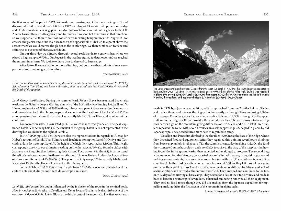
Latok V, first ascent; Latok II, south ridge, first alpine-style ascent. Doug Chabot, Mark Richey, and I arrived at base camp on the Baintha Lukpar Glacier on July 28, with the intent of climb-ing the west face of Latok III. We arrived at the end of an extended period of hot weather, which had melted much of the ice from the face, causing considerable rockfall. During accli-matization we made what we believe is the first ascent of Latok V (6,190m). [See note below on Latok nomenclature.] On August 4 we ascended the glacier to the col between Latok V and Latok IV and then up the east face to the south ridge. We continued along the crest of the ridge to a bivouac at 6,000m. On August 5 we reached the summit and descended to our bivouac, then back to base camp the following day.
Observations of rockfall on the west face of Latok III made during acclimatization trips up the glacier caused us to change our objective to the south ridge of Latok II (7,103m). At the time we did not know this route had been followed by a 17-person Italian expedition, to make
cl i m b s a N d ex P e d i t i o N s : Pa k i s ta Nth e am e r i c a N al P i N e Jo u r Na l , 2007
The untrodden summit of Pt. 5,500m on the east ridge of Latok III, showing G-Strings and Plastic Boots (900m, M7, Menard-Turgeon, 2006) on the North Flank. The climbers reached a notch in the sum-mit ridge ca 150m from the top but immediately descended the far side of the peak. Maxime Turgeon
Louis-Philippe Menard on the lower section of the north ridge of Latok I, with the summit far above. Maxime Turgeon
334 335
the first ascent of the peak in 1977. We made a reconnaissance of the route on August 14 and discovered fixed rope and trash left from 1977. On August 19 we started up the south ridge and climbed to above a large gap in the ridge that would force us out onto a glacier to the left. A serac barrier threatens this glacier, and by midday it was too hot to venture in that direction, so we stopped at 5,500m to wait for cooler early-morning temperatures. On August 20 we crossed the glacier and climbed an ice face on the opposite side. This led to a point above the seracs where we could recross the glacier to the south ridge. We then climbed an ice face and chimneys to our second bivouac, at 6,400m.
On our third day we climbed through several rock bands to a snow ridge, where we placed a high camp at 6,700m. On August 21 the weather started to deteriorate, and we reached the summit in a storm. We took two more days to descend to base camp.
After Latok II we waited to do more climbing, but poor weather and lots of new snow prevented us from doing anything else.
sTeve sWenson, AAC
Editors note: This was the second ascent of the Italian route (summit reached on August 28, 1977 by Ezio Alimonta, Toni Masé, and Renato Valentini, after the expedition had fixed 2,600m of rope) and the fourth of the summit.
Latok Group, clarification. During the summer Mark Richey, Steve Swenson, and I spent six weeks on the Baintha Lukpar Glacier, a branch of the Biafo Glacier, climbing Latoks II and V. Having copies of AAJ 1998 and 2000 with us, it became apparent there were significant errors and inconsistencies in the photos, maps, and accounts of the locations of Latoks IV and V. The accompanying photo shows the five Latoks correctly labeled. This will hopefully put to rest the confusion.
For correction sake, in AAJ 1998, p. 321, a sketch is incorrectly labeled. The peak cap-tioned Latok IV is actually Latok V, the smallest of the group. Latok IV is not represented in the drawing but would be to the right of Latok V.
In AAJ 2000, pp. 333-334 there are also misrepresentations in regards to Alexander Huber’s account of Latok IV and Omiya and Tsuchida’s attempt on Latok V. Omiya and Tus-chida did, in fact, attempt Latok V, the height of which they reported as 6,190m. This height corresponds closely to our altimeter reading on the first ascent. We also found a picket with Japanese markings, further buttressing their claims. Their account in the AAJ is correct, and the editor’s note was wrong. Furthermore, Alex and Thomas Huber climbed the lower of two obvious summits on Latok IV (6,456m). The photo by Omiya on p. 333 incorrectly labels Latok V as Latok IV, thus the Huber’s line is not in the photograph.
So the sketch in AAJ 1998 is wrong, the photo in AAJ 2000 is incorrectly labeled, and the editor’s note about Omiya and Tsuchida’s attempt is mistaken.
douG ChaBoT, AAC
Latok III, third ascent. No doubt influenced by the inclusion of the route in the seminal book, Himalayan Alpine Style, Alvaro Novellon and Oscar Perez of Spain made the third ascent of the southwest ridge of 6,949m Latok III, also the third ascent of the mountain. The first ascent was
made in 1979 by a Japanese expedition, which approached from the Baintha Lukpar Glacier and made a three-week siege of the ridge, climbing mostly on the right flank and using 1,600m of fixed rope. From the glacier the route has a vertical interval of 2,300m, though it is the upper 1,700m on the ridge itself that provides the main difficulties. The crux proved to be a steep rock barrier high on the mountain, giving difficulties of UIAA VI+ and A2. In 1988 three Ital-ians repeated the route, with seven bivouacs, in a self-supported push, helped in places by old Japanese rope. They needed three more days to regain base camp.
Novellon and Perez first climbed to the shoulder (5,300m) at the base of the ridge, where they deposited food and equipment. After they regained this point in seven hours climbing from base camp on July 21, they set off for the summit the next day in alpine style. On the 22nd they connected runnels, couloirs, and snowfields to arrive at the base of the steep barrier, hav-ing found the initial ground easier than expected and making fast progress. The second day, after an uncomfortable bivouac, they started late and climbed the step, using aid in places and making several variants, because cracks were chocked with ice. (The whole route was in icy condition.) On the third day, after another poor bivouac, at 6,500m, they left most of their gear, overcame three pitches of rock and mixed terrain, made more difficult by fatigue and lack of acclimatization, and arrived at the summit snowfield. They unroped and continued to the top, only 12 days after arriving at base camp. They rested for a day at their top bivouac and made it back to base in a roundtrip of seven days, exhausted but having removed all their equipment. They used no fixed ropes, though they did use anchors from the Japanese expedition for rap-pelling, making theirs the first ascent of the mountain in alpine style.
Lindsay Griffin, Mountain INFO, CLIMB Magazine
cl i m b s a N d ex P e d i t i o N s : Pa k i s ta Nth e am e r i c a N al P i N e Jo u r Na l , 2007
The Latok group and Baintha Lukpar Glacier from the west. (LII) Latok II (7,103m): the south ridge was repeated in alpine style in 2006. (LI) Latok I (7,145m). (LIII) Latok III (6,949m): the southwest ridge (right skyline) was repeated in alpine style during 2006. (LV) Latok V (6,190m): first ascent in 2006 by an American team via the col between V and IV, the east face, and upper south ridge. (LIV) Latok IV (6,456m). Doug Chabot

336 337
Baltoro muztagH
uli biaho aNd traNgo grouPs
Uli Biaho Tower, north face; Hainabrakk East Tower and Shipton Spire, attempts. From July 21 to 23 Slovakians Gabo Čmárik and Jozef “Dodo” Kopold made the first ascent of the north face of the spectacular 6,109m Uli Biaho Tower. They climbed the 1,900m route, named Drastis-sima, in a 54-hour roundtrip that involved hard, thin ice climbing rated VI/6. The pair used the dangerous 800m couloir originally climbed in 1979 by first ascensionists Bill Forrest, Ron Kauk, John Roskelly, and Kim Schmitz, before tackling the steep icy face right of the Ameri-cans’ east pillar. Prior to this, the two had climbed a prominent couloir to the left of the central pillar on 5,650m Hainabrakk East Tower, completing the 1,000m line, named Dolzag Dihedral (VI/6), to the east ridge. They attempted to continue to the summit but were stopped by a steep rock tower on the crest 300m below the top. An attempt on the unclimbed north face of 5,885m Shipton Spire was thwarted after 500m when Cmarik became ill from sunstroke. Kopold’s account appears earlier in the Journal.
Cat’s Ears Spire, second ascent, par-tial new route. Eric DeCariaMichael Schaefer, and I planned to climb something on Uli Biaho, but on our first night during the approach, just two hours out from Askole, Michael became seriously ill. We first thought it was the usual sort of illness caused by contaminated food and decided the best thing was to continue at Michael’s pace.
After 15 miles in nearly as many hours we arrived at Jola, the first of two stages on our route to Trango base camp. The next morning Michael was feeling a little better, so we decided to continue. Again moving at Michael’s pace, we pushed on to Paju, where we rested for a day so Michael could regain strength before we moved up to base camp.
Two days later we were on our way again and eventually reached base camp, ate dinner, and went to sleep. At 1:30 a.m., 12 hours after our arrival, Michael came to my tent in signifi-cant respiratory distress. After contacting a doctor in the United States by satellite phone, we decided to stay put and hope that Michael would recover, now that we were in a cleaner moun-tain environment. It was to no avail; 48 hours after our arrival I was on the phone again, speak-ing with the Pakistani Army and initiating a helicopter evacuation. There was no avoiding the fact that Michael was extremely sick. By 3 p.m. of our third day on the Trango Glacier, two Puma helicopters arrived, and I handed Michael off to a Pakistani Army crew. An overwhelm-ing sense of sadness came over me; I knew Michael was going to miss out on the adventure of a lifetime. As it turned out, the decision to evacuate him was a good one. His x-rays upon arrival in Skardu showed one lung nearly full of fluid and the other on its way. This was most likely due to a bacterial infection exacerbated by the altitude.
Given our position and the prevailing good weather, it seemed a good idea to climb what was closest, so by noon the next day Eric and I were five pitches up Cat’s Ears Spire. To climb as fast as possible, we left behind sleeping bags and brought little more than two Clif bars and one packet of noodles per person per day. We led in blocks of three or four pitches, with the second jumaring while carrying the pack.
The first night saw us in a small cave 12 pitches up. The pitches we climbed that day were independent of the route taken by the first ascensionists [Americans Jonny Copp and Mike Pennings in 2000 via the 1,000m route Freebird, VI 5.11d A1]. We’d encountered difficulties up to 5.11+ on serious terrain. As we eased into our bivouac that night, we gazed across the valley at Great Trango and Trango Tower, thinking that for a rock climber, this must be one of the most spectacular views in the world.
On the morning of the second day Eric and I crossed from the top of the first buttress to the base of the main wall and spent several hours trying to find a new line. However, our options were limited. In order to climb the wall above in the style we wanted, i.e., no bolts or pins and as free as possible, we unknowingly found ourselves on the first ascent route. Eric led
Eric DeCaria on the first ascent of Super Cat of the Karakoram (ca 1,000m, VI 5.11+R A1) on Cat’s Ears Spire (ca 5,550m). Micah Dash
cl i m b s a N d ex P e d i t i o N s : Pa k i s ta Nth e am e r i c a N al P i N e Jo u r Na l , 2007
The unclimbed north face of Shipton Spire (5,885m). Cmárik and Kopold hoped to climb into the large hanging couloir from the right but were forced to retreat when Cmárik became ill with sunstroke. The big pillar on the left forms the right side of the southeast face and is taken by the route Prisoners of the Shipton, climbed to within 80m of the summit (the last 14 pitches via Ship of Fools) in 2005 by Koller and Linek (UIAA VIII A3 WI5+). Dodo Kopold
338 339
off on difficult run-out terrain, free-climbing his entire first block. I took the lead a few pitches later. The climbing was wide, burly, sustained, and at times loose, leaving me with what I call “that A5 feeling.” On July 30, after two and a half days of climbing, we found ourselves on the needle-like summit of Cat’s Ears Spire (ca 5,550m) in a snowstorm. We each led and down-climbed the tiny summit block, becoming the second team to stand on it. We called our partial new route, which had 23 pitches, Super Cat of the Karakoram (1,000m, VI 5.11+R A1).
This expedition was supported by an AAC Lyman Spitzer Grant.miCah dash, AAC
Shipton Spire, Women and Chalk, second ascent and first to summit; Trango Tower, Eternal Flame, not to summit; Trango II, second known ascent; Little Shipton, first ascent. In mid-July a five-man expedition from the Austrian Tyrol, comprising Matthias Auer, Karl Dung, Ambros Sailer, and us, spent 40 days on the Trango glacier. We established two possible new routes and repeated a string of existing routes, notably the second ascent of Women and Chalk on Shipton Spire (5,885m).
Difficulties ease considerably in the upper section, and Bole terminated his route on the crest. From here eight pitches of predominantly mixed climbing via Ship of Fools lead to the summit.
Although we were the first to climb the route to the summit, we congratulate “Bubu” Bole for his performance. Climbing such an uncompromising line from the ground up in 13 days commands respect, especially since he on-sighted every pitch.
Almost all belays are equipped with two bolts, and there are in-situ pegs. However, repeating the route in complete alpine style may prove difficult, as there are no good bivouac sites in the lower section and collecting water is difficult.
The two of us also made a two-day alpine-style ascent of Eternal Flame on Trango Tower, to the top of the pillar and junction with the British route (28 pitches) but didn’t continue to the summit. We climbed the approach couloir above Trango base camp in the morning, contin-ued up the eight pitches to Sun Terrace in the afternoon, and after a bivouac reached our high point in eight hours the following day, negotiating the rock difficulties at 7b and A2.
Elsewhere, Matthias and Karl attempted The Flame via the American route, Under Fire (5.10+X A3 M5 AI 4), climbed by Brian McMahon and Josh Wharton in 2002. However, bad conditions prevented them from reaching the summit. They then climbed the normal route on Great Trango and later made the second known ascent of Trango II (6,327m). Starting early on August 19 and traveling light, the pair climbed the huge couloir on the southwest flank that falls from just north of the summit to the Trango Glacier close to Shipton base camp. At two-thirds height they headed up right through a mixed section to the final summit ice field (55° and M5). The last four pitches proved to be the crux. They reached the summit at 2 p.m. and rappelled and downclimbed their line of ascent partway, before bivouacking for the night. Next morning they made it back to base camp.
[Editor’s note: Trango II was climbed in 1995 by Antonio Aquerreta, Ferman Izco, and Mikel Zabalza, via the broad snowy southeast ridge above Trango Monk. Jonathan Clearwater, Jeremy Frimer, and Sam Johnson nearly reached the summit in 2005 after their ascent of the Severance or southwest ridge. It seems likely there could have been other ascents. It is believed the couloir used by the Austrians has been climbed for at least part of its length before.]
Lastly we two made the first ascent of a ca 5,400m tower dubbed Little Shipton. This is the triangular wall to the right of, and just beyond, Shipton Spire. Despite the uninviting appearance of the east face, we found perfect steep rock. The central part of the wall overhangs, and lack of cracks forced us to start toward the right side. After four pitches we traversed right (crux, 7a+, 1 bolt), to focus on crack systems on the ridge. One crack followed another, and after some wonderfully enjoyable pitches (mostly 6b) we reached the highest point. We rap-pelled the route using mostly flakes and blocks but placing four bolts. We climbed the 550m, 14-pitch Winds of Change (7a+) alpine style in six hours.
hansJörG auer and Thomas sCheiBer, Austria
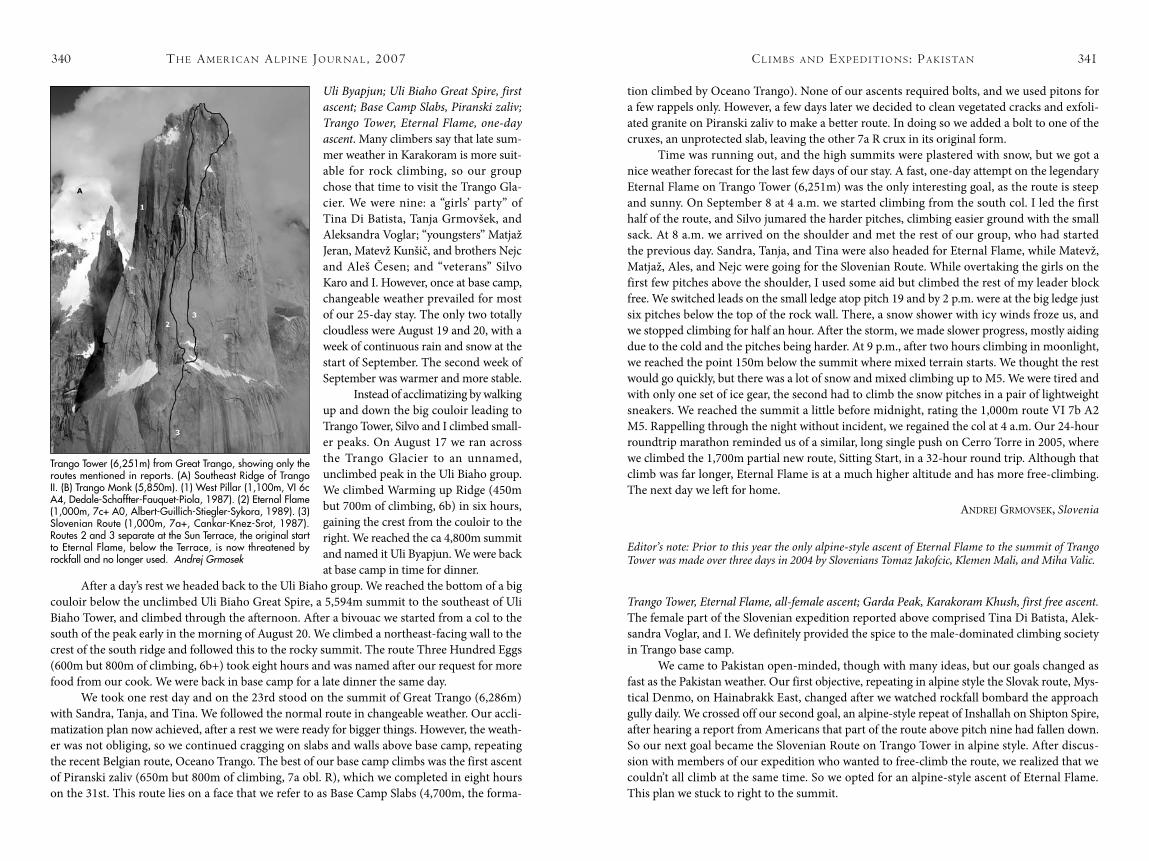
Little Shipton (ca 5,400m) showing the line of the first ascent up the east face and northeast ridge: Winds of Change (550m, 7a+, Auer-Scheiber, 2006). Hansjörg Auer collection
cl i m b s a N d ex P e d i t i o N s : Pa k i s ta Nth e am e r i c a N al P i N e Jo u r Na l , 2007
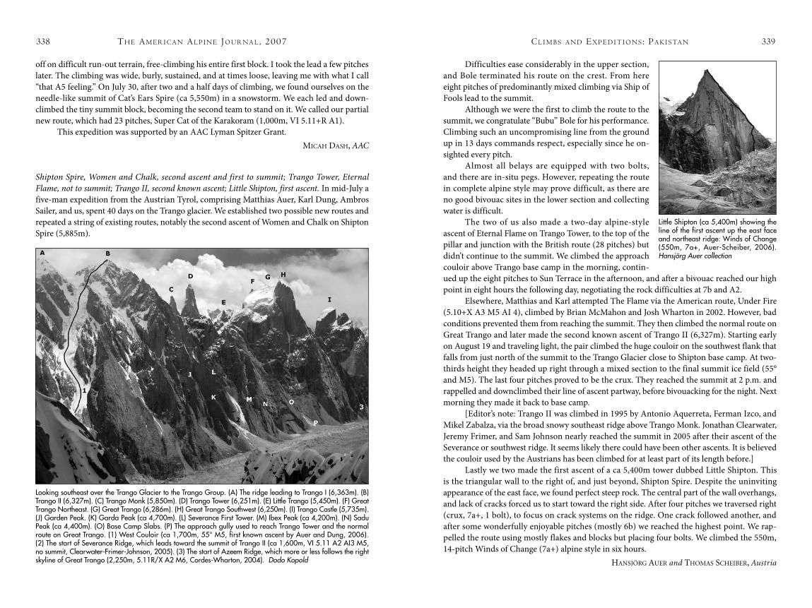
Looking southeast over the Trango Glacier to the Trango Group. (A) The ridge leading to Trango I (6,363m). (B) Trango II (6,327m). (C) Trango Monk (5,850m). (D) Trango Tower (6,251m). (E) Little Trango (5,450m). (F) Great Trango Northeast. (G) Great Trango (6,286m). (H) Great Trango Southwest (6,250m). (I) Trango Castle (5,735m). (J) Garden Peak. (K) Garda Peak (ca 4,700m). (L) Severance First Tower. (M) Ibex Peak (ca 4,200m). (N) Sadu Peak (ca 4,400m). (O) Base Camp Slabs. (P) The approach gully used to reach Trango Tower and the normal route on Great Trango. (1) West Couloir (ca 1,700m, 55° M5, first known ascent by Auer and Dung, 2006). (2) The start of Severance Ridge, which leads toward the summit of Trango II (ca 1,600m, VI 5.11 A2 AI3 M5, no summit, Clearwater-Frimer-Johnson, 2005). (3) The start of Azeem Ridge, which more or less follows the right skyline of Great Trango (2,250m, 5.11R/X A2 M6, Cordes-Wharton, 2004). Dodo Kopold
340 341
Uli Byapjun; Uli Biaho Great Spire, first ascent; Base Camp Slabs, Piranski zaliv; Trango Tower, Eternal Flame, one-day ascent. Many climbers say that late sum-mer weather in Karakoram is more suit-able for rock climbing, so our group chose that time to visit the Trango Gla-cier. We were nine: a “girls’ party” of Tina Di Batista, Tanja Grmovšek, and Aleksandra Voglar; “youngsters” Matjaž Jeran, Matevž Kunšič, and brothers Nejc and Aleš Česen; and “veterans” Silvo Karo and I. However, once at base camp, changeable weather prevailed for most of our 25-day stay. The only two totally cloudless were August 19 and 20, with a week of continuous rain and snow at the start of September. The second week of September was warmer and more stable.
Instead of acclimatizing by walking up and down the big couloir leading to Trango Tower, Silvo and I climbed small-er peaks. On August 17 we ran across the Trango Glacier to an unnamed, unclimbed peak in the Uli Biaho group. We climbed Warming up Ridge (450m but 700m of climbing, 6b) in six hours, gaining the crest from the couloir to the right. We reached the ca 4,800m summit and named it Uli Byapjun. We were back at base camp in time for dinner.
After a day’s rest we headed back to the Uli Biaho group. We reached the bottom of a big couloir below the unclimbed Uli Biaho Great Spire, a 5,594m summit to the southeast of Uli Biaho Tower, and climbed through the afternoon. After a bivouac we started from a col to the south of the peak early in the morning of August 20. We climbed a northeast-facing wall to the crest of the south ridge and followed this to the rocky summit. The route Three Hundred Eggs (600m but 800m of climbing, 6b+) took eight hours and was named after our request for more food from our cook. We were back in base camp for a late dinner the same day.
We took one rest day and on the 23rd stood on the summit of Great Trango (6,286m) with Sandra, Tanja, and Tina. We followed the normal route in changeable weather. Our accli-matization plan now achieved, after a rest we were ready for bigger things. However, the weath-er was not obliging, so we continued cragging on slabs and walls above base camp, repeating the recent Belgian route, Oceano Trango. The best of our base camp climbs was the first ascent of Piranski zaliv (650m but 800m of climbing, 7a obl. R), which we completed in eight hours on the 31st. This route lies on a face that we refer to as Base Camp Slabs (4,700m, the forma-
tion climbed by Oceano Trango). None of our ascents required bolts, and we used pitons for a few rappels only. However, a few days later we decided to clean vegetated cracks and exfoli-ated granite on Piranski zaliv to make a better route. In doing so we added a bolt to one of the cruxes, an unprotected slab, leaving the other 7a R crux in its original form.
Time was running out, and the high summits were plastered with snow, but we got a nice weather forecast for the last few days of our stay. A fast, one-day attempt on the legendary Eternal Flame on Trango Tower (6,251m) was the only interesting goal, as the route is steep and sunny. On September 8 at 4 a.m. we started climbing from the south col. I led the first half of the route, and Silvo jumared the harder pitches, climbing easier ground with the small sack. At 8 a.m. we arrived on the shoulder and met the rest of our group, who had started the previous day. Sandra, Tanja, and Tina were also headed for Eternal Flame, while Matevž, Matjaž, Ales, and Nejc were going for the Slovenian Route. While overtaking the girls on the first few pitches above the shoulder, I used some aid but climbed the rest of my leader block free. We switched leads on the small ledge atop pitch 19 and by 2 p.m. were at the big ledge just six pitches below the top of the rock wall. There, a snow shower with icy winds froze us, and we stopped climbing for half an hour. After the storm, we made slower progress, mostly aiding due to the cold and the pitches being harder. At 9 p.m., after two hours climbing in moonlight, we reached the point 150m below the summit where mixed terrain starts. We thought the rest would go quickly, but there was a lot of snow and mixed climbing up to M5. We were tired and with only one set of ice gear, the second had to climb the snow pitches in a pair of lightweight sneakers. We reached the summit a little before midnight, rating the 1,000m route VI 7b A2 M5. Rappelling through the night without incident, we regained the col at 4 a.m. Our 24-hour roundtrip marathon reminded us of a similar, long single push on Cerro Torre in 2005, where we climbed the 1,700m partial new route, Sitting Start, in a 32-hour round trip. Although that climb was far longer, Eternal Flame is at a much higher altitude and has more free-climbing. The next day we left for home.
andreJ Grmovsek, Slovenia
Editor’s note: Prior to this year the only alpine-style ascent of Eternal Flame to the summit of Trango Tower was made over three days in 2004 by Slovenians Tomaz Jakofcic, Klemen Mali, and Miha Valic.
Trango Tower, Eternal Flame, all-female ascent; Garda Peak, Karakoram Khush, first free ascent. The female part of the Slovenian expedition reported above comprised Tina Di Batista, Alek-sandra Voglar, and I. We definitely provided the spice to the male-dominated climbing society in Trango base camp.
We came to Pakistan open-minded, though with many ideas, but our goals changed as fast as the Pakistan weather. Our first objective, repeating in alpine style the Slovak route, Mys-tical Denmo, on Hainabrakk East, changed after we watched rockfall bombard the approach gully daily. We crossed off our second goal, an alpine-style repeat of Inshallah on Shipton Spire, after hearing a report from Americans that part of the route above pitch nine had fallen down. So our next goal became the Slovenian Route on Trango Tower in alpine style. After discus-sion with members of our expedition who wanted to free-climb the route, we realized that we couldn’t all climb at the same time. So we opted for an alpine-style ascent of Eternal Flame. This plan we stuck to right to the summit.
Trango Tower (6,251m) from Great Trango, showing only the routes mentioned in reports. (A) Southeast Ridge of Trango II. (B) Trango Monk (5,850m). (1) West Pillar (1,100m, VI 6c A4, Dedale-Schaffter-Fauquet-Piola, 1987). (2) Eternal Flame (1,000m, 7c+ A0, Albert-Guillich-Stiegler-Sykora, 1989). (3) Slovenian Route (1,000m, 7a+, Cankar-Knez-Srot, 1987). Routes 2 and 3 separate at the Sun Terrace, the original start to Eternal Flame, below the Terrace, is now threatened by rockfall and no longer used. Andrej Grmosek
cl i m b s a N d ex P e d i t i o N s : Pa k i s ta Nth e am e r i c a N al P i N e Jo u r Na l , 2007
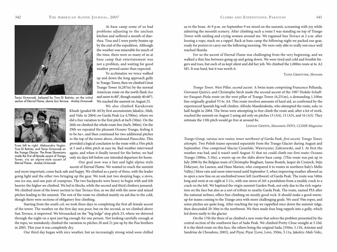
342 cl i m b s a N d ex P e d i t i o N s : Pa k i s ta N 343
At base camp some of us had problems adjusting to the unclean kitchen and suffered a month of diar-rhea. Tina and I were pretty beaten up by the end of the expedition. Although the weather was miserable for much of the time, there were so many of us at base camp that entertainment was not a problem, and waiting for good weather proved easier than expected.
To acclimatize we twice walked up and down the long approach gully to Trango Tower, then we climbed Great Trango Tower (6,287m) by the normal American route on the north flank (ice and snow to 80°, though mainly 40-60°). We reached the summit on August 23.
We also climbed Karakoram Khush (graded 6b A0 by first ascensionists Jakafcic, Mali, and Valic in 2004) on Garda Peak (ca 4,700m), where we did a free variation to the first pitch at 6a/b (50m). On the 26th we climbed the whole route free (6a/b, 300m). On the 29th we repeated the pleasant Oceano Trango, feeling it to be 6a+, and then continued for two additional pitches to the top of the tower above, christened Pinocchio. This provided a logical conclusion to the route with a 55m pitch at 5 and a 60m pitch at easy 6a. Bad weather intervened again, and when it finally turned for the better, we had only six days left before our intended departure for home.
Our goal now was a fast and light alpine-style ascent of Eternal Flame. We wanted to reach the summit
and more important, come back safe and happy. We climbed as a party of three, with the leader going light and the other two bringing up the gear. We took just two sleeping bags, a stove, one ice axe, and one pair of crampons. The two backpacks were heavy to begin with and felt heavier the higher we climbed. We led in blocks, while the second and third climbers jumared. We climbed most of the lower section to Sun Terrace free, as we did with the snow and mixed pitches leading to the summit. The rest of the route we climbed mainly on aid due to the cold, though there were sections of obligatory free climbing.
Starting from the south col, we took three days to completing the first all-female ascent of the tower. The weather on the first day was poor, but on the second, as we climbed above Sun Terrace, it improved. We bivouacked on the “big ledge” atop pitch 23, where we shivered through the night on a spot just big enough for one person. Not looking carefully enough at the topo, we mistakenly climbed the variation to pitches 20 and 21 put up by the Pou brothers in 2005. This year it was completely dry.
Our third day began with nice weather, but an increasingly strong wind soon chilled
th e am e r i c a N al P i N e Jo u r Na l , 2007
us to the bone. At 9 p.m. on September 9 we stood on the summit, screaming with joy while admiring the moonlit scenery. After climbing such a route I was standing on top of Trango Tower with smiling and crying women around me. We regained Sun Terrace at 2 a.m. after loosing a rope, stuck on a rappel. Back at base camp the following night we packed our gear, ready for porters to carry out the following morning. We were only able to really rest once we’d reached Skardu.
For us the ascent of Eternal Flame was challenging from the very beginning, and we walked a thin line between going up and going down. We were tired and cold and frostbit fin-gers and toes, but each of us kept silent and did her job. We climbed the 1,000m route at 6c A2 M5. It was hard, but it was worth it.
TanJa Grmovsek, Slovenia
Trango Tower, West Pillar, second ascent. A Swiss team comprising Francesco Pellanda, Giovanni Quirici, and Christophe Steck made the second ascent of the 1987 Dedale-Schaff-ter-Fauquet-Piola route on the west pillar of Trango Tower (6,251m), a demanding 1,100m line originally graded VI 6c A4. This route involves amounts of hard aid, as confirmed by the experienced Spanish big wall climber, Alfredo Mandinabeita, who attempted the route, solo, to half-height in 2004. The Swiss were attempting to free climb the route and, after a lot of work, reached the summit on August 2 using aid only on pitches 13 (A4), 15 (A3), and 16 (A3). They estimate the 13th pitch would go free at around 8a.
Lindsay Griffin, Mountain INFO, CLIMB Magazine
Trango Group, various new routes; tower northwest of Garda Peak, first ascent; Trango Tower, attempts. Two Polish teams operated separately from the Trango Glacier during August and September. One comprised Maciej Ciesielski, Wawrzyniec Zakrzewski, and I. At first the weather was bad, and it wasn’t until August 31 that we could climb our first route: Oceano Trango (300m, 5.10a), a warm-up on the slabs above base camp. [This route was put up in July 2006 by the Belgian team of Christophe Bingham, Sanne Bostels, Jasper de Coninck, Stijn Dekeyser, An Laenen, and Hans Marien, who compared it to routes in northern Italy’s Mello Valley.] More rain and snow intervened until September 5, when improving weather allowed us to open a new line on an unclimbed tower left (northwest) of Garda Peak. The route was 540m long and went at on-sight at 5.11c, with one move of A0: a pendulum from a muddy crack to a crack on the left. We baptized the virgin summit Garden Peak, not only due to the rich vegeta-tion on the face but also as a sort of tribute to nearby Garda Peak. The route, named PIA after the national airlines, offers fine climbing on mostly good rock. It should make a good warm-up for teams coming to the Trango area with more challenging goals. We used 70m ropes, and some pitches are quite long. After reaching the top we rappelled once down the summit ridge, then descended 20-30m to the northwest. We then made four long rappels into a gully, which led down easily to the glacier.
On the 17th the three of us climbed a new route that solves the problem presented by the central section of the southwest face of Sadu Peak. We climbed Pretty Close onsight at 5.10d. It is the third route on this face, the others being the original Sadu [350m, 5.11b, Antoine and Sandrine de Choudens, 2003], and Piyar, Piyar [Love, Love, 350m, 5.11a, Jakofcic-Mali-Valic,
Tanja Grmovsek, belayed by Tina Di Batista, on the initial section of Eternal Flame, above Sun Terrace. Andrej Grmovsek
From left to right: Aleksandra Voglar, Tina Di Batista, and Tanja Grmovsek on the Trango Glacier. The three Slovenians made the first all-female ascent of Trango Tower, via an alpine-style ascent of Eternal Flame. Andrej Grmovsek
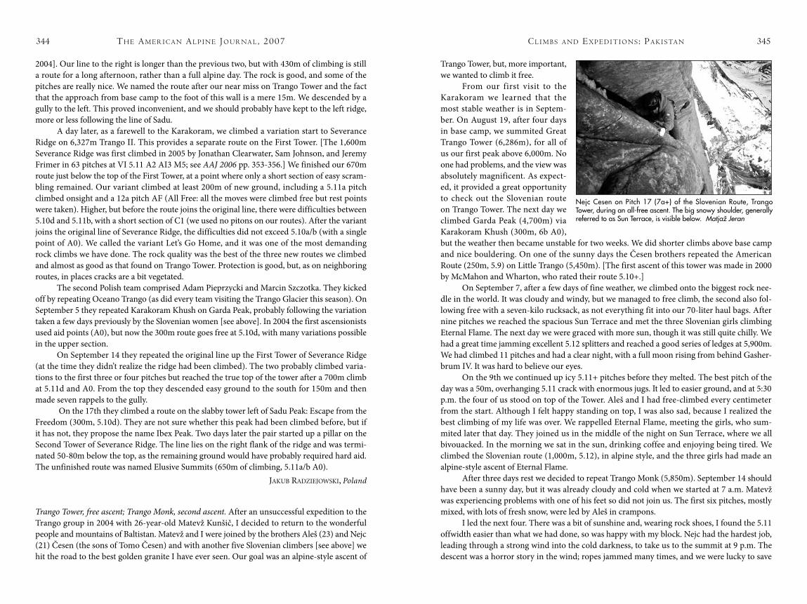
th e am e r i c a N al P i N e Jo u r Na l , 2007344 cl i m b s a N d ex P e d i t i o N s : Pa k i s ta N 345
2004]. Our line to the right is longer than the previous two, but with 430m of climbing is still a route for a long afternoon, rather than a full alpine day. The rock is good, and some of the pitches are really nice. We named the route after our near miss on Trango Tower and the fact that the approach from base camp to the foot of this wall is a mere 15m. We descended by a gully to the left. This proved inconvenient, and we should probably have kept to the left ridge, more or less following the line of Sadu.
A day later, as a farewell to the Karakoram, we climbed a variation start to Severance Ridge on 6,327m Trango II. This provides a separate route on the First Tower. [The 1,600m Severance Ridge was first climbed in 2005 by Jonathan Clearwater, Sam Johnson, and Jeremy Frimer in 63 pitches at VI 5.11 A2 AI3 M5; see AAJ 2006 pp. 353-356.] We finished our 670m route just below the top of the First Tower, at a point where only a short section of easy scram-bling remained. Our variant climbed at least 200m of new ground, including a 5.11a pitch climbed onsight and a 12a pitch AF (All Free: all the moves were climbed free but rest points were taken). Higher, but before the route joins the original line, there were difficulties between 5.10d and 5.11b, with a short section of C1 (we used no pitons on our routes). After the variant joins the original line of Severance Ridge, the difficulties did not exceed 5.10a/b (with a single point of A0). We called the variant Let’s Go Home, and it was one of the most demanding rock climbs we have done. The rock quality was the best of the three new routes we climbed and almost as good as that found on Trango Tower. Protection is good, but, as on neighboring routes, in places cracks are a bit vegetated.
The second Polish team comprised Adam Pieprzycki and Marcin Szczotka. They kicked off by repeating Oceano Trango (as did every team visiting the Trango Glacier this season). On September 5 they repeated Karakoram Khush on Garda Peak, probably following the variation taken a few days previously by the Slovenian women [see above]. In 2004 the first ascensionists used aid points (A0), but now the 300m route goes free at 5.10d, with many variations possible in the upper section.
On September 14 they repeated the original line up the First Tower of Severance Ridge (at the time they didn’t realize the ridge had been climbed). The two probably climbed varia-tions to the first three or four pitches but reached the true top of the tower after a 700m climb at 5.11d and A0. From the top they descended easy ground to the south for 150m and then made seven rappels to the gully.
On the 17th they climbed a route on the slabby tower left of Sadu Peak: Escape from the Freedom (300m, 5.10d). They are not sure whether this peak had been climbed before, but if it has not, they propose the name Ibex Peak. Two days later the pair started up a pillar on the Second Tower of Severance Ridge. The line lies on the right flank of the ridge and was termi-nated 50-80m below the top, as the remaining ground would have probably required hard aid. The unfinished route was named Elusive Summits (650m of climbing, 5.11a/b A0).
JakuB radzieJoWski, Poland
Trango Tower, free ascent; Trango Monk, second ascent. After an unsuccessful expedition to the Trango group in 2004 with 26-year-old Matevž Kunšič, I decided to return to the wonderful people and mountains of Baltistan. Matevž and I were joined by the brothers Aleš (23) and Nejc (21) Česen (the sons of Tomo Česen) and with another five Slovenian climbers [see above] we hit the road to the best golden granite I have ever seen. Our goal was an alpine-style ascent of
Trango Tower, but, more important, we wanted to climb it free.
From our first visit to the Karakoram we learned that the most stable weather is in Septem-ber. On August 19, after four days in base camp, we summited Great Trango Tower (6,286m), for all of us our first peak above 6,000m. No one had problems, and the view was absolutely magnificent. As expect-ed, it provided a great opportunity to check out the Slovenian route on Trango Tower. The next day we climbed Garda Peak (4,700m) via Karakoram Khush (300m, 6b A0), but the weather then became unstable for two weeks. We did shorter climbs above base camp and nice bouldering. On one of the sunny days the Česen brothers repeated the American Route (250m, 5.9) on Little Trango (5,450m). [The first ascent of this tower was made in 2000 by McMahon and Wharton, who rated their route 5.10+.]
On September 7, after a few days of fine weather, we climbed onto the biggest rock nee-dle in the world. It was cloudy and windy, but we managed to free climb, the second also fol-lowing free with a seven-kilo rucksack, as not everything fit into our 70-liter haul bags. After nine pitches we reached the spacious Sun Terrace and met the three Slovenian girls climbing Eternal Flame. The next day we were graced with more sun, though it was still quite chilly. We had a great time jamming excellent 5.12 splitters and reached a good series of ledges at 5,900m. We had climbed 11 pitches and had a clear night, with a full moon rising from behind Gasher-brum IV. It was hard to believe our eyes.
On the 9th we continued up icy 5.11+ pitches before they melted. The best pitch of the day was a 50m, overhanging 5.11 crack with enormous jugs. It led to easier ground, and at 5:30 p.m. the four of us stood on top of the Tower. Aleš and I had free-climbed every centimeter from the start. Although I felt happy standing on top, I was also sad, because I realized the best climbing of my life was over. We rappelled Eternal Flame, meeting the girls, who sum-mited later that day. They joined us in the middle of the night on Sun Terrace, where we all bivouacked. In the morning we sat in the sun, drinking coffee and enjoying being tired. We climbed the Slovenian route (1,000m, 5.12), in alpine style, and the three girls had made an alpine-style ascent of Eternal Flame.
After three days rest we decided to repeat Trango Monk (5,850m). September 14 should have been a sunny day, but it was already cloudy and cold when we started at 7 a.m. Matevž was experiencing problems with one of his feet so did not join us. The first six pitches, mostly mixed, with lots of fresh snow, were led by Aleš in crampons.
I led the next four. There was a bit of sunshine and, wearing rock shoes, I found the 5.11 offwidth easier than what we had done, so was happy with my block. Nejc had the hardest job, leading through a strong wind into the cold darkness, to take us to the summit at 9 p.m. The descent was a horror story in the wind; ropes jammed many times, and we were lucky to save
Nejc Cesen on Pitch 17 (7a+) of the Slovenian Route, Trango Tower, during an all-free ascent. The big snowy shoulder, generally referred to as Sun Terrace, is visible below. Matjaž Jeran
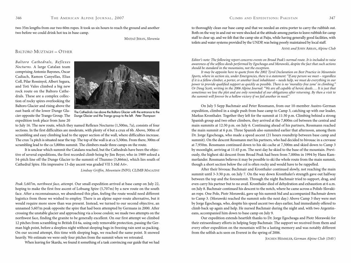
th e am e r i c a N al P i N e Jo u r Na l , 2007346 cl i m b s a N d ex P e d i t i o N s : Pa k i s ta N 347
two 35m lengths from our two 60m ropes. It took us six hours to reach the ground and another two before we could drink hot tea in base camp.
maTJaž Jeran, Slovenia
baltoro muztagh – other
Baltoro Cathedral s , Ref lexes Nocturns. A large Catalan team comprising Antonio Bayones, Oscar Cadiach, Ramon Canyellas, Elias Coll, Pilar Rossinyol, Albert Segura, and Toti Vales climbed a big new rock route on the Baltoro Cathe-drals. These are a complex collec-tion of rocky spires overlooking the Baltoro Glacier and rising above the east bank of the lower Dunge Gla-cier opposite the Trango Group. The expedition took place from June 20 to July 16. The new route, which they named Reflexes Nocturns (1,500m, 7a), consists of four sections. In the first difficulties are moderate, with plenty of 4 but a crux of 6b. Above, 300m of scrambling and easy climbing lead to the upper section of the wall, where difficulties increase. The crux 7a pitch is situated near the top. The top of the wall is at ca 5,500m. From there, 300m of scrambling lead to the ca 5,800m summit. The climbers made three camps on the route.
It is unclear which summit the Catalans reached, but the Cathedrals have been the objec-tive of several expeditions, the first recorded climb being by Jim Beyer, who in 1989 soloed a 54-pitch line off the Dunge Glacier to the summit of Thunmo (5,866m), which lies south of Cathedral Spire. His impressive 13-day ascent was graded VII 5.10d A4+.
Lindsay Griffin, Mountain INFO, CLIMB MAgAzINe
Peak 5,607m, northwest face, attempt. Our small expedition arrived at base camp on July 22, hoping to make the first free ascent of Lobsang Spire (5,707m) by a new route on the south face. After a reconnaissance, we abandoned this plan, feeling the route would need different logistics from those we wished to employ. There is an alpine super-route alternative, but it would require more snow than was present. Instead, we turned to our second objective, an unnamed 5,607m peak opposite the spire that had been attempted by Germans in 2000. After crossing the unstable glacier and approaching via a loose couloir, we made two attempts on the northwest face, finding the granite to be generally excellent. On our first attempt we climbed 12 pitches from scrambling to British E4 6a, using only removable protection, passing the Ger-man high point, before a sleepless night without sleeping bags in freezing rain sent us packing. On our second attempt, this time with sleeping bags, we reached the same point. It snowed heavily. We estimate we were only four pitches from the summit when we retreated.
When leaving for Skardu, we found it something of a task convincing our guide that we had
to thoroughly clean our base camp and that we needed an extra porter to carry the rubbish out. Both on the way in and out we were shocked at the attitude among parties to leave rubbish for camp staff to clear up, and we felt that the camp site at Paiju, while having generally good facilities, with toilets and water systems provided by the UNDP, was being poorly maintained by local staff.
anne and John arran, Alpine Club
Editor’s note: The following report concerns events on Broad Peak’s normal route. It is included to raise awareness of the selfless deeds performed by Egocheaga and Morawski, despite the fact that such actions should be standard in the mountains, not the exception.
It may be apposite here to quote from the 2002 Tyrol Declaration on Best Practice in Mountain Sports, where in section six, under Emergencies, there is a statement: “If any person we meet – regardless if it is a fellow climber, a porter, or another local inhabitant – needs help, we must do everything in our power to provide qualified support as quickly as possible. There is no ‘morality-free zone’ in climbing.” Or Doug Scott, writing in the 2006 Alpine Journal: “We are all capable of heroic deeds…. It is just that sometimes we lose the plot and are only reminded of our obligations after returning. By then a visit to the summit will forever be a hollow victory if we fail another in need.”
On July 5 Sepp Bachmair and Peter Ressmann, from our 10-member Austro-German expedition, climbed in a single push from base camp to Camp 3, catching up with our leader, Markus Kronthaler. Together they left for the summit at 11:30 p.m. Climbing behind a strong Spanish group and two other climbers, they arrived at the 7,800m col between the central and main summits at 12:30 p.m. on July 6. Continuing ahead of his partners, Ressmann reached the main summit at 6 p.m. Three Spanish also summited earlier that afternoon, among them Dr. Jorge Egocheaga, who made a speed ascent (21 hours roundtrip between base camp and summit). On the descent Ressmann met his partners, who had decided to bivouac in a crevasse at 7,950m. Ressmann continued down to his ski cache at 7,500m and skied down to Camp 3 by moonlight, arriving at 11:45 p.m. The next day he skied to the base of the mountain. Previ-ously, the highest ski descent from Broad Peak had been from 7,000m in 1994 by Hans Kam-merlander. Ressmann believes it may be possible to ski the whole route from the main summit, though a short section below the col is often rocky and would have to be rappelled.
After their bivouac Bachmair and Kronthaler continued slowly, not reaching the main summit until 3-3:30 p.m. on July 7. On the way down Kronthaler’s strength gave out halfway between the top and the foresummit. Through the night Bachmair tried to support, drag, and even carry his partner but to no avail. Kronthaler died of dehydration and exhaustion at 6 a.m. on July 8. Bachmair continued his descent to the notch, where he came across a Polish-Slovaki-an rope. One Pole, Piotr Morawski, gave up his summit bid and accompanied Bachmair down to Camp 3. (Morawski reached the summit solo the next day.) Above Camp 3 they were met by Jorge Egocheaga, who, despite his speed ascent two days earlier, had immediately offered to climb back up again and help. He nursed Bachmair during the night and, with two Argentin-eans, accompanied him down to base camp on July 9.
Our expedition extends heartfelt thanks to Dr. Jorge Egocheaga and Piotr Morawski for their extraordinary efforts in helping Sepp Bachmair. The support we received from them and every other expedition on the mountain will be a lasting memory and was notably different from the selfish acts seen on Everest in the spring of 2006.
JoChen hemmLeB, German Alpine Club (DAV)
The Cathedrals rise above the Baltoro Glacier with the entrance to the Dunge Glacier and the Trango group to the left. Peter Thompson
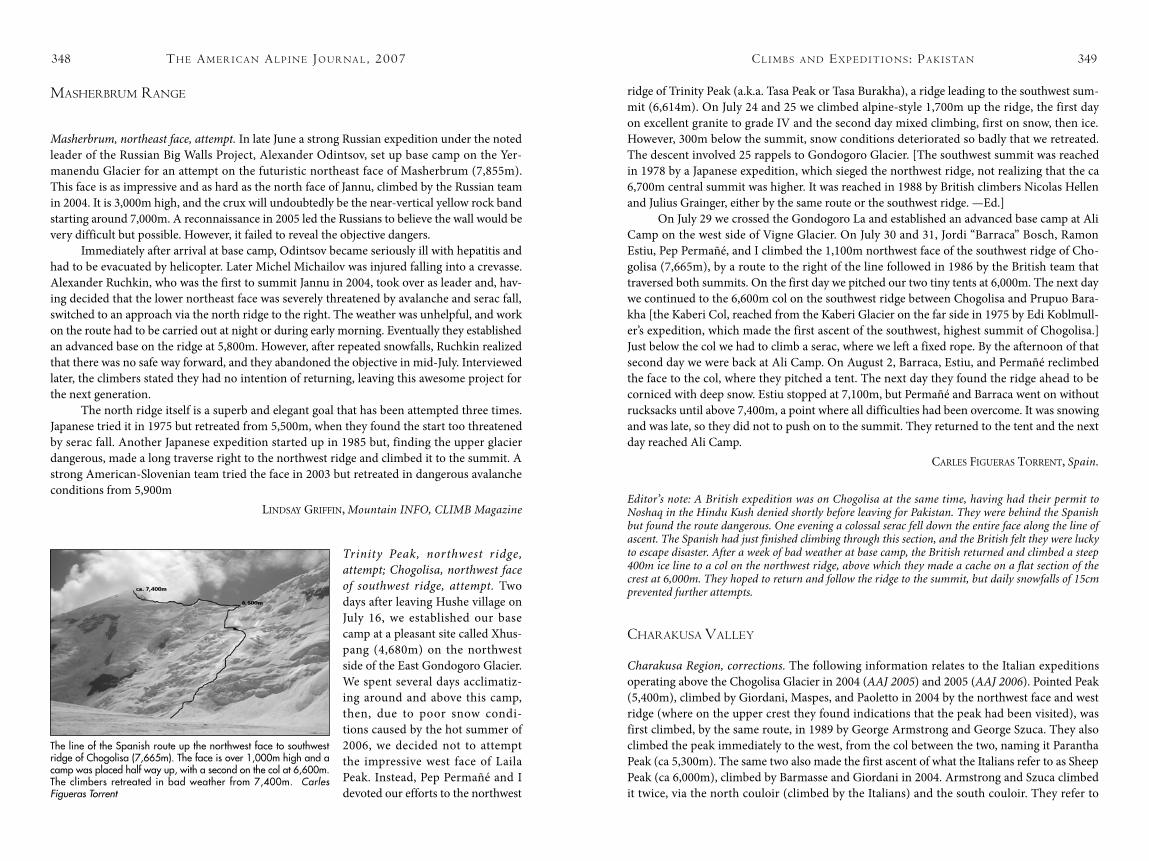
th e am e r i c a N al P i N e Jo u r Na l , 2007348 cl i m b s a N d ex P e d i t i o N s : Pa k i s ta N 349
masherbrum raNge
Masherbrum, northeast face, attempt. In late June a strong Russian expedition under the noted leader of the Russian Big Walls Project, Alexander Odintsov, set up base camp on the Yer-manendu Glacier for an attempt on the futuristic northeast face of Masherbrum (7,855m). This face is as impressive and as hard as the north face of Jannu, climbed by the Russian team in 2004. It is 3,000m high, and the crux will undoubtedly be the near-vertical yellow rock band starting around 7,000m. A reconnaissance in 2005 led the Russians to believe the wall would be very difficult but possible. However, it failed to reveal the objective dangers.
Immediately after arrival at base camp, Odintsov became seriously ill with hepatitis and had to be evacuated by helicopter. Later Michel Michailov was injured falling into a crevasse. Alexander Ruchkin, who was the first to summit Jannu in 2004, took over as leader and, hav-ing decided that the lower northeast face was severely threatened by avalanche and serac fall, switched to an approach via the north ridge to the right. The weather was unhelpful, and work on the route had to be carried out at night or during early morning. Eventually they established an advanced base on the ridge at 5,800m. However, after repeated snowfalls, Ruchkin realized that there was no safe way forward, and they abandoned the objective in mid-July. Interviewed later, the climbers stated they had no intention of returning, leaving this awesome project for the next generation.
The north ridge itself is a superb and elegant goal that has been attempted three times. Japanese tried it in 1975 but retreated from 5,500m, when they found the start too threatened by serac fall. Another Japanese expedition started up in 1985 but, finding the upper glacier dangerous, made a long traverse right to the northwest ridge and climbed it to the summit. A strong American-Slovenian team tried the face in 2003 but retreated in dangerous avalanche conditions from 5,900m
Lindsay Griffin, Mountain INFO, CLIMB Magazine
Trinity Peak, northwest ridge, attempt; Chogolisa, northwest face of southwest ridge, attempt. Two days after leaving Hushe village on July 16, we established our base camp at a pleasant site called Xhus-pang (4,680m) on the northwest side of the East Gondogoro Glacier. We spent several days acclimatiz-ing around and above this camp, then, due to poor snow condi-tions caused by the hot summer of 2006, we decided not to attempt the impressive west face of Laila Peak. Instead, Pep Permañé and I devoted our efforts to the northwest
ridge of Trinity Peak (a.k.a. Tasa Peak or Tasa Burakha), a ridge leading to the southwest sum-mit (6,614m). On July 24 and 25 we climbed alpine-style 1,700m up the ridge, the first day on excellent granite to grade IV and the second day mixed climbing, first on snow, then ice. However, 300m below the summit, snow conditions deteriorated so badly that we retreated. The descent involved 25 rappels to Gondogoro Glacier. [The southwest summit was reached in 1978 by a Japanese expedition, which sieged the northwest ridge, not realizing that the ca 6,700m central summit was higher. It was reached in 1988 by British climbers Nicolas Hellen and Julius Grainger, either by the same route or the southwest ridge. —Ed.]
On July 29 we crossed the Gondogoro La and established an advanced base camp at Ali Camp on the west side of Vigne Glacier. On July 30 and 31, Jordi “Barraca” Bosch, Ramon Estiu, Pep Permañé, and I climbed the 1,100m northwest face of the southwest ridge of Cho-golisa (7,665m), by a route to the right of the line followed in 1986 by the British team that traversed both summits. On the first day we pitched our two tiny tents at 6,000m. The next day we continued to the 6,600m col on the southwest ridge between Chogolisa and Prupuo Bara-kha [the Kaberi Col, reached from the Kaberi Glacier on the far side in 1975 by Edi Koblmull-er’s expedition, which made the first ascent of the southwest, highest summit of Chogolisa.] Just below the col we had to climb a serac, where we left a fixed rope. By the afternoon of that second day we were back at Ali Camp. On August 2, Barraca, Estiu, and Permañé reclimbed the face to the col, where they pitched a tent. The next day they found the ridge ahead to be corniced with deep snow. Estiu stopped at 7,100m, but Permañé and Barraca went on without rucksacks until above 7,400m, a point where all difficulties had been overcome. It was snowing and was late, so they did not to push on to the summit. They returned to the tent and the next day reached Ali Camp.
CarLes fiGueras TorrenT, Spain.
Editor’s note: A British expedition was on Chogolisa at the same time, having had their permit to Noshaq in the Hindu Kush denied shortly before leaving for Pakistan. They were behind the Spanish but found the route dangerous. One evening a colossal serac fell down the entire face along the line of ascent. The Spanish had just finished climbing through this section, and the British felt they were lucky to escape disaster. After a week of bad weather at base camp, the British returned and climbed a steep 400m ice line to a col on the northwest ridge, above which they made a cache on a flat section of the crest at 6,000m. They hoped to return and follow the ridge to the summit, but daily snowfalls of 15cm prevented further attempts.
charakusa Valley
Charakusa Region, corrections. The following information relates to the Italian expeditions operating above the Chogolisa Glacier in 2004 (AAJ 2005) and 2005 (AAJ 2006). Pointed Peak (5,400m), climbed by Giordani, Maspes, and Paoletto in 2004 by the northwest face and west ridge (where on the upper crest they found indications that the peak had been visited), was first climbed, by the same route, in 1989 by George Armstrong and George Szuca. They also climbed the peak immediately to the west, from the col between the two, naming it Parantha Peak (ca 5,300m). The same two also made the first ascent of what the Italians refer to as Sheep Peak (ca 6,000m), climbed by Barmasse and Giordani in 2004. Armstrong and Szuca climbed it twice, via the north couloir (climbed by the Italians) and the south couloir. They refer to
The line of the Spanish route up the northwest face to southwest ridge of Chogolisa (7,665m). The face is over 1,000m high and a camp was placed half way up, with a second on the col at 6,600m. The climbers retreated in bad weather from 7,400m. Carles Figueras Torrent
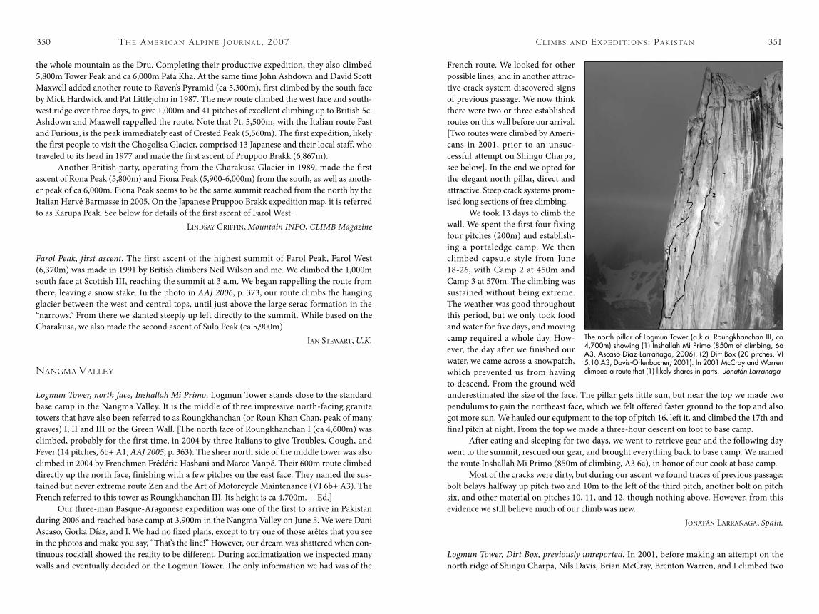
th e am e r i c a N al P i N e Jo u r Na l , 2007350 cl i m b s a N d ex P e d i t i o N s : Pa k i s ta N 351
the whole mountain as the Dru. Completing their productive expedition, they also climbed 5,800m Tower Peak and ca 6,000m Pata Kha. At the same time John Ashdown and David Scott Maxwell added another route to Raven’s Pyramid (ca 5,300m), first climbed by the south face by Mick Hardwick and Pat Littlejohn in 1987. The new route climbed the west face and south-west ridge over three days, to give 1,000m and 41 pitches of excellent climbing up to British 5c. Ashdown and Maxwell rappelled the route. Note that Pt. 5,500m, with the Italian route Fast and Furious, is the peak immediately east of Crested Peak (5,560m). The first expedition, likely the first people to visit the Chogolisa Glacier, comprised 13 Japanese and their local staff, who traveled to its head in 1977 and made the first ascent of Pruppoo Brakk (6,867m).
Another British party, operating from the Charakusa Glacier in 1989, made the first ascent of Rona Peak (5,800m) and Fiona Peak (5,900-6,000m) from the south, as well as anoth-er peak of ca 6,000m. Fiona Peak seems to be the same summit reached from the north by the Italian Hervé Barmasse in 2005. On the Japanese Pruppoo Brakk expedition map, it is referred to as Karupa Peak. See below for details of the first ascent of Farol West.
Lindsay Griffin, Mountain INFO, CLIMB Magazine
Farol Peak, first ascent. The first ascent of the highest summit of Farol Peak, Farol West (6,370m) was made in 1991 by British climbers Neil Wilson and me. We climbed the 1,000m south face at Scottish III, reaching the summit at 3 a.m. We began rappelling the route from there, leaving a snow stake. In the photo in AAJ 2006, p. 373, our route climbs the hanging glacier between the west and central tops, until just above the large serac formation in the “narrows.” From there we slanted steeply up left directly to the summit. While based on the Charakusa, we also made the second ascent of Sulo Peak (ca 5,900m).
ian sTeWarT, U.K.
NaNgma Valley
Logmun Tower, north face, Inshallah Mi Primo. Logmun Tower stands close to the standard base camp in the Nangma Valley. It is the middle of three impressive north-facing granite towers that have also been referred to as Roungkhanchan (or Roun Khan Chan, peak of many graves) I, II and III or the Green Wall. [The north face of Roungkhanchan I (ca 4,600m) was climbed, probably for the first time, in 2004 by three Italians to give Troubles, Cough, and Fever (14 pitches, 6b+ A1, AAJ 2005, p. 363). The sheer north side of the middle tower was also climbed in 2004 by Frenchmen Frédéric Hasbani and Marco Vanpé. Their 600m route climbed directly up the north face, finishing with a few pitches on the east face. They named the sus-tained but never extreme route Zen and the Art of Motorcycle Maintenance (VI 6b+ A3). The French referred to this tower as Roungkhanchan III. Its height is ca 4,700m. —Ed.]
Our three-man Basque-Aragonese expedition was one of the first to arrive in Pakistan during 2006 and reached base camp at 3,900m in the Nangma Valley on June 5. We were Dani Ascaso, Gorka Díaz, and I. We had no fixed plans, except to try one of those arêtes that you see in the photos and make you say, “That’s the line!” However, our dream was shattered when con-tinuous rockfall showed the reality to be different. During acclimatization we inspected many walls and eventually decided on the Logmun Tower. The only information we had was of the
French route. We looked for other possible lines, and in another attrac-tive crack system discovered signs of previous passage. We now think there were two or three established routes on this wall before our arrival. [Two routes were climbed by Ameri-cans in 2001, prior to an unsuc-cessful attempt on Shingu Charpa, see below]. In the end we opted for the elegant north pillar, direct and attractive. Steep crack systems prom-ised long sections of free climbing.
We took 13 days to climb the wall. We spent the first four fixing four pitches (200m) and establish-ing a portaledge camp. We then climbed capsule style from June 18-26, with Camp 2 at 450m and Camp 3 at 570m. The climbing was sustained without being extreme. The weather was good throughout this period, but we only took food and water for five days, and moving camp required a whole day. How-ever, the day after we finished our water, we came across a snowpatch, which prevented us from having to descend. From the ground we’d underestimated the size of the face. The pillar gets little sun, but near the top we made two pendulums to gain the northeast face, which we felt offered faster ground to the top and also got more sun. We hauled our equipment to the top of pitch 16, left it, and climbed the 17th and final pitch at night. From the top we made a three-hour descent on foot to base camp.
After eating and sleeping for two days, we went to retrieve gear and the following day went to the summit, rescued our gear, and brought everything back to base camp. We named the route Inshallah Mi Primo (850m of climbing, A3 6a), in honor of our cook at base camp.
Most of the cracks were dirty, but during our ascent we found traces of previous passage: bolt belays halfway up pitch two and 10m to the left of the third pitch, another bolt on pitch six, and other material on pitches 10, 11, and 12, though nothing above. However, from this evidence we still believe much of our climb was new.
JonaTán LarrañaGa, Spain.
Logmun Tower, Dirt Box, previously unreported. In 2001, before making an attempt on the north ridge of Shingu Charpa, Nils Davis, Brian McCray, Brenton Warren, and I climbed two
The north pillar of Logmun Tower (a.k.a. Roungkhanchan III, ca 4,700m) showing (1) Inshallah Mi Primo (850m of climbing, 6a A3, Ascaso-Díaz-Larrañaga, 2006). (2) Dirt Box (20 pitches, VI 5.10 A3, Davis-Offenbacher, 2001). In 2001 McCray and Warren climbed a route that (1) likely shares in parts. Jonatán Larrañaga
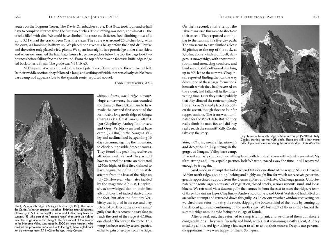
th e am e r i c a N al P i N e Jo u r Na l , 2007352 cl i m b s a N d ex P e d i t i o N s : Pa k i s ta N 353
routes on the Logmun Tower. The Davis-Offenbacher route, Dirt Box, took four-and-a-half days to complete after we fixed the first two pitches. The climbing was steep, and almost all the cracks filled with dirt. We could have climbed the route much faster, free-climbing most of it up to 5.11+, had the cracks been Yosemite clean. The route was around 20 pitches long, with the crux, A3 hooking, halfway up. We placed one rivet at a belay before the hand drill broke and thereafter only placed a few pitons. We spent four nights in a portaledge under clear skies, and when we launched the haul bags from a ledge two pitches below the top, the bags took two bounces before falling free to the ground. From the top of the tower a fantastic knife-edge ridge led back to terra firma. The grade was VI 5.10 A3.
McCray and Warren climbed to the top of pitch two of this route and then broke out left. In their middle section, they followed a long, and striking offwidth that was clearly visible from base camp and appears close to the Spanish route [reported above].
Todd offenBaCher, AAC
Shingu Charpa, north ridge, attempt. Huge controversy has surrounded the claim by three Ukrainians to have made the coveted first ascent of the formidably long north ridge of Shingu Charpa (a.k.a. Great Tower, 5,600m). Igor Chaplinsky, Andrey Rodiontsev, and Orest Verbitsky arrived at base camp (3,900m) in the Nangma Val-ley and acclimatized by spending 10 days circumnavigating the mountain, to check out possible descent routes. They found the peak impressive on all sides and realized they would have to rappel the route, an estimated 1,550m high. At first they claimed to have begun their final alpine-style attempt from the base of the ridge on July 20. However, when later tackled by the magazine Alpinist, Chaplin-sky acknowledged that on their first attempt they had indeed started from the foot, but after the first day Ver-bitsky was injured in the eye, and they retreated by descending an easy ramp/gully that slants across the east face to reach the crest of the ridge at 4,650m, one-third of the way up the route. This ramp has been used by several parties, either to gain or escape from the ridge.
On their second, final attempt the Ukrainians used this ramp to short-cut their ascent. They reported continu-ing to the summit in a five-day push. The trio seems to have climbed at least 58 pitches to the top of the rock, at 5,400m, above which a difficult, dan-gerous snowy ridge, with snow mush-rooms and menacing cornices, and hard ice and difficult mixed climbing up to M5, led to the summit. Chaplin-sky reported finding that on the way down, one of these large formations, beneath which they had traversed on the ascent, had fallen off in the inter-vening time. Later they stated publicly that they climbed the route completely free at 7a or 7a+ and placed no bolts on the ascent, though three or four for rappel anchors. The team was nomi-nated for the Piolet d’Or. But did they really climb the route free and did they really reach the summit? Kelly Cordes takes up the story.
Shingu Charpa, north ridge, attempts and deception. In July, sitting in the gorgeous Nangma Valley base camp, I hacked up nasty chunks of something laced with blood, stricken with who-knows-what. My ultra-strong and ultra-capable partner, Josh Wharton, paced away the time until I recovered enough to try again.
We’d made an attempt that failed when I fell sick one-third of the way up Shingu Charpa’s 1,550m north ridge, a stunning-looking and highly sought line for which we received generous, greatly appreciated support from the Lyman Spitzer and Polartec Challenge grants. Unfortu-nately, the route largely consisted of vegetation, closed cracks, serious runouts, mud, and loose blocks. We retreated via a descent gully that comes in from the east to meet the ridge. A team of three Ukrainians (Igor Chaplinsky, Andrey Rodiontsev, and Orest Verbitsky) had failed on an earlier attempt and retreated down this gully. As I blew our weather window recovering, we watched them return to retry the route, skipping the bottom third of the route by coming up the descent gully and continuing up the north ridge. We lost sight of them as they turned the summit ridge onto the side facing the village of Kande.
After a week out, they returned to camp triumphant, and we offered them our sincere congratulations. They were friendly and kind, with Orest remaining mostly silent, Andrey speaking a little, and Igor talking a lot, eager to tell us about their success. Despite our personal disappointment, we were happy for them. So it goes.
The 1,550m north ridge of Shingu Charpa (5,600m). The line of the Cordes-Wharton attempt is marked, finishing after 45 pitches, all free up to 5.11+, some 60m below and 150m away from the summit. (R) is the start of the "escape ramp" that slants up right to meet the ridge at one-third height. The first ascent of this summit in the Nangma Valley was made in 2000 by three Koreans, who climbed the prominent snow couloir to the right, then angled back left up the west face (5.11 A2) to the top. Kelly Cordes
Day three on the north ridge of Shingu Charpa (5,600m). Kelly Cordes starting up the 40th pitch. There are still a few more difficult pitches before reaching the summit ridge. Josh Wharton
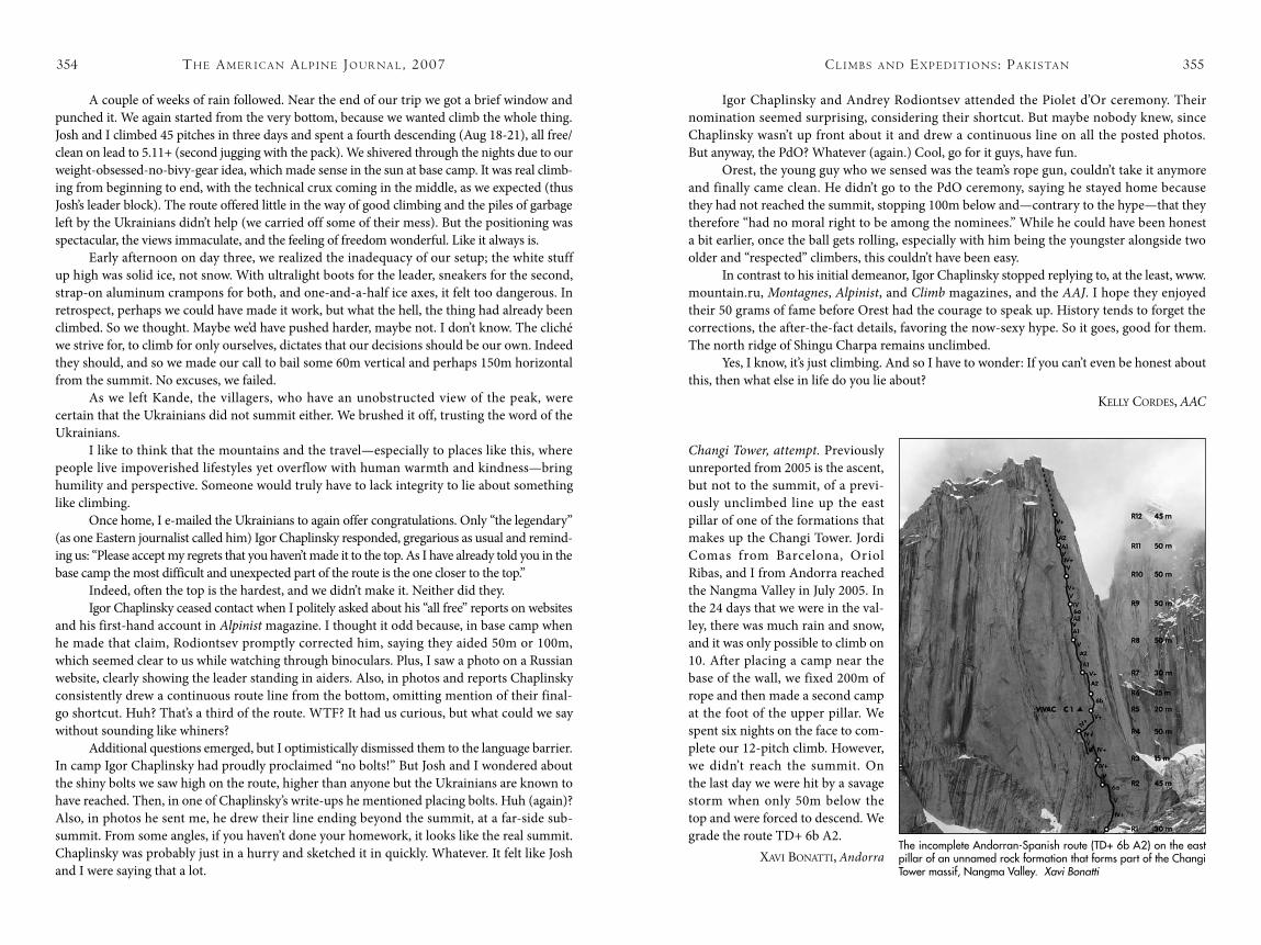
th e am e r i c a N al P i N e Jo u r Na l , 2007354 cl i m b s a N d ex P e d i t i o N s : Pa k i s ta N 355
A couple of weeks of rain followed. Near the end of our trip we got a brief window and punched it. We again started from the very bottom, because we wanted climb the whole thing. Josh and I climbed 45 pitches in three days and spent a fourth descending (Aug 18-21), all free/clean on lead to 5.11+ (second jugging with the pack). We shivered through the nights due to our weight-obsessed-no-bivy-gear idea, which made sense in the sun at base camp. It was real climb-ing from beginning to end, with the technical crux coming in the middle, as we expected (thus Josh’s leader block). The route offered little in the way of good climbing and the piles of garbage left by the Ukrainians didn’t help (we carried off some of their mess). But the positioning was spectacular, the views immaculate, and the feeling of freedom wonderful. Like it always is.
Early afternoon on day three, we realized the inadequacy of our setup; the white stuff up high was solid ice, not snow. With ultralight boots for the leader, sneakers for the second, strap-on aluminum crampons for both, and one-and-a-half ice axes, it felt too dangerous. In retrospect, perhaps we could have made it work, but what the hell, the thing had already been climbed. So we thought. Maybe we’d have pushed harder, maybe not. I don’t know. The cliché we strive for, to climb for only ourselves, dictates that our decisions should be our own. Indeed they should, and so we made our call to bail some 60m vertical and perhaps 150m horizontal from the summit. No excuses, we failed.
As we left Kande, the villagers, who have an unobstructed view of the peak, were certain that the Ukrainians did not summit either. We brushed it off, trusting the word of the Ukrainians.
I like to think that the mountains and the travel—especially to places like this, where people live impoverished lifestyles yet overflow with human warmth and kindness—bring humility and perspective. Someone would truly have to lack integrity to lie about something like climbing.
Once home, I e-mailed the Ukrainians to again offer congratulations. Only “the legendary” (as one Eastern journalist called him) Igor Chaplinsky responded, gregarious as usual and remind-ing us: “Please accept my regrets that you haven’t made it to the top. As I have already told you in the base camp the most difficult and unexpected part of the route is the one closer to the top.”
Indeed, often the top is the hardest, and we didn’t make it. Neither did they.Igor Chaplinsky ceased contact when I politely asked about his “all free” reports on websites
and his first-hand account in Alpinist magazine. I thought it odd because, in base camp when he made that claim, Rodiontsev promptly corrected him, saying they aided 50m or 100m, which seemed clear to us while watching through binoculars. Plus, I saw a photo on a Russian website, clearly showing the leader standing in aiders. Also, in photos and reports Chaplinsky consistently drew a continuous route line from the bottom, omitting mention of their final-go shortcut. Huh? That’s a third of the route. WTF? It had us curious, but what could we say without sounding like whiners?
Additional questions emerged, but I optimistically dismissed them to the language barrier. In camp Igor Chaplinsky had proudly proclaimed “no bolts!” But Josh and I wondered about the shiny bolts we saw high on the route, higher than anyone but the Ukrainians are known to have reached. Then, in one of Chaplinsky’s write-ups he mentioned placing bolts. Huh (again)? Also, in photos he sent me, he drew their line ending beyond the summit, at a far-side sub-summit. From some angles, if you haven’t done your homework, it looks like the real summit. Chaplinsky was probably just in a hurry and sketched it in quickly. Whatever. It felt like Josh and I were saying that a lot.
Igor Chaplinsky and Andrey Rodiontsev attended the Piolet d’Or ceremony. Their nomination seemed surprising, considering their shortcut. But maybe nobody knew, since Chaplinsky wasn’t up front about it and drew a continuous line on all the posted photos. But anyway, the PdO? Whatever (again.) Cool, go for it guys, have fun.
Orest, the young guy who we sensed was the team’s rope gun, couldn’t take it anymore and finally came clean. He didn’t go to the PdO ceremony, saying he stayed home because they had not reached the summit, stopping 100m below and—contrary to the hype—that they therefore “had no moral right to be among the nominees.” While he could have been honest a bit earlier, once the ball gets rolling, especially with him being the youngster alongside two older and “respected” climbers, this couldn’t have been easy.
In contrast to his initial demeanor, Igor Chaplinsky stopped replying to, at the least, www.mountain.ru, Montagnes, Alpinist, and Climb magazines, and the AAJ. I hope they enjoyed their 50 grams of fame before Orest had the courage to speak up. History tends to forget the corrections, the after-the-fact details, favoring the now-sexy hype. So it goes, good for them. The north ridge of Shingu Charpa remains unclimbed.
Yes, I know, it’s just climbing. And so I have to wonder: If you can’t even be honest about this, then what else in life do you lie about?
keLLy Cordes, AAC
Changi Tower, attempt. Previously unreported from 2005 is the ascent, but not to the summit, of a previ-ously unclimbed line up the east pillar of one of the formations that makes up the Changi Tower. Jordi Comas from Barcelona, Oriol Ribas, and I from Andorra reached the Nangma Valley in July 2005. In the 24 days that we were in the val-ley, there was much rain and snow, and it was only possible to climb on 10. After placing a camp near the base of the wall, we fixed 200m of rope and then made a second camp at the foot of the upper pillar. We spent six nights on the face to com-plete our 12-pitch climb. However, we didn’t reach the summit. On the last day we were hit by a savage storm when only 50m below the top and were forced to descend. We grade the route TD+ 6b A2.
xavi BonaTTi, AndorraThe incomplete Andorran-Spanish route (TD+ 6b A2) on the east pillar of an unnamed rock formation that forms part of the Changi Tower massif, Nangma Valley. Xavi Bonatti
![INDEX [c498469.r69.cf2.rackcdn.com]c498469.r69.cf2.rackcdn.com/1986/341_index_aaj1986.pdf · BoJor, Ovidiu, 251 Boks (Tien Shari,, USSR), 304 Bolivar (Merida, Sierra Nevada de, Venezuela),](https://img.pdfslide.us/doc/110x75/5a84c2e17f8b9a882e8bc09f/index-c498469r69cf2-c498469r69cf2-ovidiu-251-boks-tien-shari-ussr.jpg)

![INDEX [c498469.r69.cf2.rackcdn.com]c498469.r69.cf2.rackcdn.com/1976/index_1976_aaj.pdf · 2011-04-06 · INDEX All entries in the American Alpine Club Journal Index are arranged alphabetically](https://img.pdfslide.us/doc/110x75/5e9454866cd49a64af3ebe24/index-c498469r69cf2-c498469r69cf2-2011-04-06-index-all-entries-in-the.jpg)
![INDEX [c498469.r69.cf2.rackcdn.com]c498469.r69.cf2.rackcdn.com/1990/370_index_aaj1990.pdf · 2011-04-06 · Gorilla Monsoon, John Long, 323-25 High Altitude Medicine and Pathology,](https://img.pdfslide.us/doc/110x75/5f8aa2219f021b7f284e73da/index-c498469r69cf2-c498469r69cf2-2011-04-06-gorilla-monsoon-john-long.jpg)
![INDEX [c498469.r69.cf2.rackcdn.com]c498469.r69.cf2.rackcdn.com/1987/371_index_aaj1987.pdf · INDEX Volume 29 l Issue 61 l 1987 Compiled by Patricia A. Fletcher This issue comprises](https://img.pdfslide.us/doc/110x75/5ba031f109d3f2fb538c1ebf/index-c498469r69cf2-c498469r69cf2-index-volume-29-l-issue-61-l-1987.jpg)


![INDEX [c498469.r69.cf2.rackcdn.com]c498469.r69.cf2.rackcdn.com/1985/385_index_aaj1985.pdf · INDEX Baudha (Nepal Himalaya), 125 ... Bhrigu Parbat (Garhwal Himalaya), ... Bindu GUI](https://img.pdfslide.us/doc/110x75/5b076c5d7f8b9a93418e2b96/index-c498469r69cf2-c498469r69cf2-baudha-nepal-himalaya-125-bhrigu.jpg)

![INDEX [c498469.r69.cf2.rackcdn.com]c498469.r69.cf2.rackcdn.com/1980/715_index_aaj1980.pdf · INDEX Volume XXII, No. 2, Issue 54, 1980 This volume is in two parts, each of which is](https://img.pdfslide.us/doc/110x75/5e786f87e16f91286d01e59c/index-c498469r69cf2-c498469r69cf2-index-volume-xxii-no-2-issue-54-1980.jpg)
![INDEX [c498469.r69.cf2.rackcdn.com]c498469.r69.cf2.rackcdn.com/1995/390_index_aaj1995.pdf · Mountnineermg. Catalogue of the Graham Brown and Lloyd Collectionr, 357 National Llbr‘uv](https://img.pdfslide.us/doc/110x75/5fbcfdb4599e291eef2dc8dc/index-c498469r69cf2-c498469r69cf2-mountnineermg-catalogue-of-the-graham.jpg)

![INDEX [c498469.r69.cf2.rackcdn.com]c498469.r69.cf2.rackcdn.com/1992/index_1992_aaj.pdf · 2011. 4. 6. · INDEX Volume 34 l Issue 66 l 1992 Compiled by Patricia A. Fletcher This issue](https://img.pdfslide.us/doc/110x75/6145ee3d8f9ff812541ff11e/index-c498469r69cf2-c498469r69cf2-2011-4-6-index-volume-34-l-issue.jpg)