Embed Size (px)
Citation preview

Soils and Geology 3
164 • Chapter 3 Kuiu Timber Sale FEIS
3.10 Soils and Geology The following discussions are based on pre-existing data combined with additional data collected in the field for the Kuiu Timber Sale project, and is confined to the Project Area and proposed units. Applicable soils direction is included in the Forest Plan, Chapter 4 and Appendix C. General and site-specific mitigation measures are listed in the road and unit cards.
Within the Project Area 6,624 acres of carbonate bedrock have been identified along the northeastern boundary. Karst develops where carbonates exist due to the action of water on soluble rock. The dissolution of the rock results in the development of internal drainage that can produce sinking streams, closed depressions, and other solution landforms such as sinkholes, collapsed channels, and caves.
The Tongass National Forest has developed management guidelines which strive to protect and maintain the function and biological significance of karst landscapes and caves found, per the requirements of the Federal Cave Resources Protection Act of 1988. All proposed alternatives have been modified so that no timber harvest, road construction, or quarry development would occur in these areas or along the drainages which flow to them.
Scoping comments for the Project Area did not identify any specific soil related issues. The Forest Plan, however, has identified two concerns pertinent to proposed timber harvests that are applicable. The concerns are: 1) soil productivity loss due to roads, rock pits, and detrimental soil conditions created as a result of timber harvests, and 2) erosion due to management-induced mass wasting (i.e. various types of landslides: avalanches, debris and earth flows, soil creep, slumps, etc.).
Soil Quality Standards have been established to ensure that managed activities do not create significant impairment to the productivity of the land and directs that no more than 15 percent of an activity area be detrimentally disturbed through management practices (FSM 2554.03-10). National Forest System (NFS) roads are considered a dedicated use of the soil resource and are not included when calculating detrimental soil conditions, whereas temporary roads are included. Design criteria for new NFS road and the BMPs are included in Appendix B and respond to any soils concerns.
3.10.2.1 Soil Productivity Deep well-drained soils are the most productive for tree growth. Maintaining soil drainage while minimizing soil erosion are both key to soil productivity in the Project Area due to high annual precipitation
3.10.1 Karst
3.10.2 Soils
Soils and Geology 3
Kuiu Timber Sale FEIS Chapter 3 • 165
and the overall topography of the area. Tree rooting in the area is generally shallow and soils are covered by thick matting created from accumulating and decaying organic matter.
3.10.2.2 Soil Disturbance and Erosion Soil disturbance is part of a natural and ongoing process within a forest ecosystem. Erosion is considered one phase of soil disturbance, initiated by natural processes such as heavy or consistent precipitation, landslides, and windthrow. Soil disturbance can also be initiated by land management activities (e.g. road construction, timber harvest, and rock pit development (Swanston 1995). The level of disturbance varies with management practices and site characteristics.
Mass movement ratings have been developed to assist management at the planning level for analyzing landslide potential. The value used to classify a rating or mass movement index (MMI) is explained in the Soils Specialist report available in the Kuiu Timber Sale planning record. The MMI ratings used, identified by Swanston (1995), are generally associated with the following slope gradients:
• MMI – 1 (low): 5 to 35 percent
• MMI – 2 (moderate): 36 to 51 percent
• MMI – 3 (high): 52 to 72 percent
• MMI – 4 (extreme): over 72 percent
Two landslide inventories within Southeast Alaska, based on different scales, provide a relative understanding of the relationship between timber harvests and landslides. The first inventory, conducted by Swanston and Marion (1991) was based on landslides over 100 cubic yards in size that occurred between 1963 and 1983 in Southeast Alaska. They found that landslides were 3.4 times more likely to occur in harvested areas than in unharvested areas. Swanston (1991) noted, “as a general rule, landslides in harvested areas are significantly smaller, occur at lower elevations, develop on gentler gradients, and tend to travel shorter distances [than naturally induced landslides]”.
The areas considered hazardous or most prone to landslides are those with steep slopes or areas with distinct slip-planes. During heavy rainfall or snowfall events these areas have a higher likelihood of failing, especially if previously disturbed by blasting for rock pits, road pioneering, side casting of excavated material, or ground-based logging (Swanston and Marion 1991).
In the other landslide analysis, slides that occurred in Southeast Alaska between 1971 and 1991 were reviewed and noted by Landwehr (1998, unpub.) from aerial photos, regardless of their size. Landwehr’s study
3.10.3 Mass Movement

3 Environment and Effects
166 • Chapter 3 Kuiu Timber Sale FEIS
also concluded that landslides are more likely to occur on harvested areas than what would occur naturally (Table 3-59).
Table 3-59 Landslide studies by Swanston and Marion (1991) and Landwehr (1998 unpub.)
Landslides
20-Year Analysis Slides /
unharvested acres
Slides / unharvested
acres
Ratio between harvested and unharvested
Slides / mile of road
construction
Swanston and Marion (1991) 1963-1983
1 slide/8,021 acres
1 slide/2,348 acres
3.42 higher in harvested N/A
Landwehr (1998, unpub.) 1971-1991
1 slide/6,239 acres
1 slide/622 acres
10.03 higher in harvested 1 slide/19 mile
One factor associated with ground-based logging practices and subsequent landslides includes root deterioration following a harvest. Where steep slopes exist, slope sheer strength is provided by the binding action of the roots in the soil. Following harvest, root systems begin to decay and the soil-root fabric begins to weaken. The weakened soil-root fabric can further reduce the slope safety factor when a moderate storm or an increase in water pressure is realized from frequent precipitation or snow melt and may result in a landslide (Ziemer 1981). In the case of a clearcut harvest, root reinforcement is delayed for ten to fifteen years until new growth (particularly root density or weight) restores slope sheer strength and the binding action of the soil-root fabric.
At the Forest Planning level, areas with slope gradients of 72 percent or more are initially removed from the tentatively suitable timber base due to a higher risk of landslides; however, the Forest Supervisor or District Ranger at the project level may approve timber harvest on these slopes on a case-by-case basis. Their decision includes the consideration of an on-site analysis of slope stability (documented on a Soil Stability Investigation Report), an assessment of impacts of potentially accelerated erosion on downslope areas and downstream fish habitats, as well as other affected resources and economic factors.
3.10.4.1 Past Actions Approximately 22 percent of the Project Area has been harvested in the past 30 years, mostly from valley bottoms and gentle slopes (Table
3.10.4 Existing Condition

Soils and Geology 3
Kuiu Timber Sale FEIS Chapter 3 • 167
3-60). Of the 10,393 acres already harvested, 6,911 were harvested prior to 1980 and have had more than 25 years for root net reinforcement and vegetative regrowth.
Table 3-60. Acres previously harvested in the Kuiu Timber Sale Area by MMI Class
MMI Class Project Area Acres
Acres Harvested
% Hazard Class Harvested
1 – Low 19,284 5,273 27%
2 – Moderate 20,862 4,668 22%
3 – High 2,595 190 7%
4 – Extreme 3,361 262 8%
Totals 46,102 10,393 22%
3.10.4.2 Mass Movement A landslide inventory specific to the Project Area was completed in December 2003 using aerial photos taken in 1998, and Forest Service land surveys completed in the 1960s and 1980s. Through the inventory, 57 known landslides were identified within the Project Area varying in size from 0.5 to 88 acres in both managed and natural non-managed areas. The 88-acre slide was a large rotational failure that occurred after a rain-on-snow event in December 1988. This slide today is partially revegetated and recovering. No units are proposed on or near this slide.
Predicting landslides is difficult due to the number of factors that are involved and their interaction with one another. Frequent precipitation and windthrow are two natural events, that, when combined with excessive soil disturbance and root deterioration, can be catalysts for a landslide.
The inventory of landslides in the Project Area found that per 1,000 acres, landslides for MMI-1 and MMI-2 soils were two times higher in harvested areas than in unharvested areas (Table 3-61 and Chart 3-4). For MMI-4 soils, there were almost three times as many landslides in harvested areas compared to unharvested areas. This inventory analysis supports previously referenced research which stated more landslides occur in harvested areas (Swanston and Marion 1991, Landwehr 1998, unpub.).

3 Environment and Effects
168 • Chapter 3 Kuiu Timber Sale FEIS
Table 3-61. Inventory of landslides within the Project Area
Unharvested acres Harvested acres
MMI Rating Number of Landslides
Number of slides/1000
acresa
Number of Landslides
Number of slides/1000
acresb
1 – Low 1 0.07 1 0.19
2 – Moderate 23 1.42 14 2.99
3 – High 3 1.25 0 N/A
4 – Extreme 12 3.87 3 11.45 a Ratio was developed from unharvested acres within the Kuiu Timber Sale Area Table 3-60.
b Ratio was calculated from harvested acres within the Kuiu Timber Sale Area Table 3-60.
Chart 3-4. Kuiu Timber Sale Area landslide comparison
Kuiu Timber Sale Area Landslide Comparison
0 2 4 6 8 10 12
1
2
3
4
MMI Rating
Landslides Per 1,000 Acres
Harvested Acres
Unharvested Acres

46251
6403
46252
6425
46090
6441 6448
4609
2
6442
6402
6409 6409
46098 64156427
64126414
46420 461016425 641064106402
6411
6413 46127
6418
6402
46096
6417
64196401
64216422
6417
6435
4615246152
4615
4
6415
6444
64456416
46360
46355
6436 6429
6402
6408
6426
6407
6405 6415
6437
64286447
46360
6446
64046428
46094
6443
4602
1
46091
503
109b
209
207
211
418
402
404
405
103d
103c
101
504
112
302
303
305
308
307
205
204208b
208a 208
212210111
401
417
412
410
409
403414
416
415
500
1000
2000
1 500
2500
3000
1 500
1 000
150
0
3000
15
00
500
500
500
5 00
2500
15
00
1000
3 00 0
500
500
1000
1500
500
500
1500
1500
1500
15 0 0
1000
500
3000
15 00
2000
1500
2000
2000
1500
1000
15
00
2000
1500
1500
500
100
0
500
500
500
1 500
500
500
1500
300 0
15
00
1500
1500
500
500
500
500
1500
2000
10003000
2500
10 00
2500
500
2000
1500
2000
2000
500
1500
50 0
500
10 00
1000
1500
1 000
20
00
1 500
500
1 500
2500
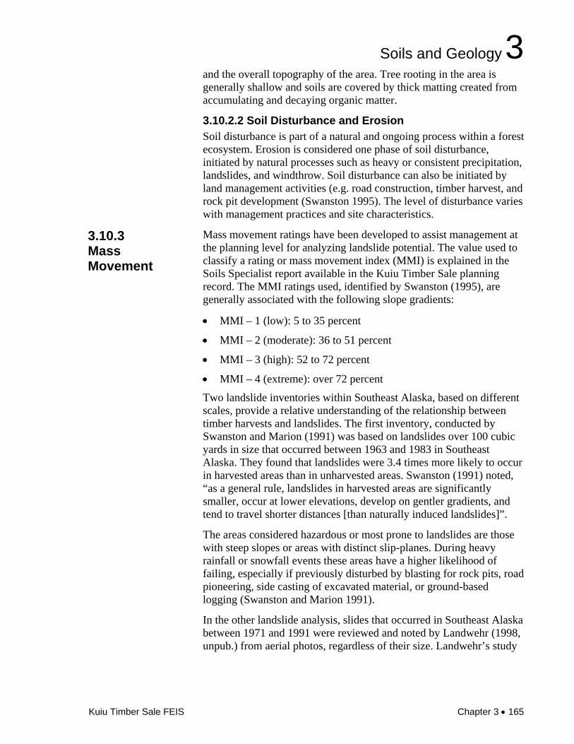
Saginaw Bay
Security Bay
Legend
MMI-4 Extreme ( >72% Slope Gradient)
MMI-3 High ( 52-71%)
Productive Old-Growth
Managed Stands
Lakes/Saltwater
Unit Pool
Non-National Forest
Project Area Boundary
Stream Value Class I & II
Existing Open Roads
500ft Contour Interval
Roads in Storage (Closed)
Decommissioned Roads
±
u:/w
orks
pace
/kui
u_ro
aded
/feis
/plo
ts/fe
is_p
lots
/f3_1
0soi
ls.m
xd 0
7-09
-07
EP
Kuiu Timber SaleFigure 3-10
MMI-3 and MMI-4 Soils within the Kuiu Timber Sale Area
Keku Strait
KadakeBay
0 1 2 3 40.5Miles

Soils and Geology 3
170 • Chapter 3 Kuiu Timber Sale FEIS
Blank

Soils and Geology 3
171 • Chapter 3 Kuiu Timber Sale FEIS
3.10.5.1 Methods Data used for soil analysis comes from existing resources such as the Soil Resource Inventory (SRI), the landslide inventory, and field data collected through on-site surveys conducted throughout the summer of 2004. Road acres are based on an average road width of 40 feet (from top of cutslope to toe of fillslope) or 4.85 acres per mile.
Effects are estimated based on the following measures:
• Estimated acres of detrimental soil conditions in harvest units based on yarding method,
• Acres of timber harvest on slopes over 72 percent, acres of timber harvest by MMI Class and estimated numbers of landslides, and
• Cumulative acres of soil removed from productivity by roads, detrimental soil conditions within harvest units, and estimated numbers of landslides.
3.10.5.2. Area of Analysis The soils analysis area for the Kuiu Timber Sale is within the same boundary as that used to describe the boundary for the overall project (Kuiu Timber Sale Area Draft EIS, 1-10). The total area (46,102 acres) is selected as the boundary area for the soils analysis because it is naturally separated from surrounding areas by water along the northeast and northwest shorelines and by the general topography along the southeast, southwest and southern areas.
3.10.5.3 Soil Productivity Detrimental soil conditions are often created by harvest activities such as road building and yarding activities. Literature pertaining to actual acres of soil impacted through detrimental disturbance is limited for soils within Southeast Alaska; however, a survey was performed by Landwehr and Nowacki (1999, unpub.) where detrimental soil conditions were monitored as a result of a clearcut timber harvest on northern Prince of Wales Island. They found that partial suspension and shovel yarding within the clearcut harvest areas resulted in five percent disturbance of the acres harvested, and helicopter yarding resulted in three percent disturbance.
Table 3-62 shows an estimate of detrimental soil disturbance by alternative associated with harvest. Note the estimates given in Table 3-62 are based on clearcut harvest. The partial harvest prescriptions would likely result in less soil displacement, therefore the numbers presented are considered to be conservative.
3.10.5 Environmental Consequences

3 Environment and Effects
172 • Chapter 3 Kuiu Timber Sale FEIS
Table 3-62. Acres of detrimental soil disturbance from harvest and temporary road construction by alternative
Soil disturbance Alt 1 Alt 2 Alt 3 Alt 4 Alt 5
Ground yardinga,b
0 24 39 62 60
Helicopter yardinga,b
0 0 0 5 0
Temporary road construction 0 7 10 19 17
Total acres soil disturbance 0 31 49 86 77
a HA = Harvest Acres
b EDA = Estimated Disturbance Acres (5% ground yarding, 3% helicopter yarding)
The intent of the Regional Soil Quality Standards is to maintain soil productivity within acceptable standards. The Standards allow up to 15 percent of the productive forestland to be in a detrimental condition. No harvest or road construction is planned for Alternative 1; any disturbance would be caused by natural events. All action alternatives would maintain the soil productivity within the acceptable standards. Alternative 4 is estimated to produce the highest number of acres of detrimental disturbance (86 acres), followed by Alternative 5 (77 acres), Alternative 3 (49 acres) and Alternative 2 (31 acres). As stated earlier, the acres may be overestimated for all action alternatives, with the exception of Alternative 5 because they include partial harvest units.
3.10.5.4 Mass Movement Based on analysis provided by Swanston (1991) landslide potential is projected to be higher (twice that in harvested versus unharvested areas) for all alternatives on MMI-1 and 2 soils, and three times as likely on MMI-4 soils. Table 3-63 shows the acres of proposed timber harvest by alternative within each MMI Class and Figure 3-10 shows the MMI-3 and MMI-4 soils within the Project Area. All proposed units with MMI-4 soils were determined stable through soil stability analyses.

Soils and Geology 3
Kuiu Timber Sale FEIS Chapter 3 • 173
Table 3-63. Acresa of MMI in proposed units by alternative
MMI Class Alt. 1 Alt. 2 Alt. 3 Alt. 4 Alt. 5
1– Low 0 146 115 374 298
2 – Moderate 0 329 669 999 894
3 – High 0 2 2 0 2
4 – Extreme 0 0 0 14 14
Total Acres 0 477 786 1,387 1,208 a Variations in acres are the result of rounding.
If Alternative 1 is implemented, landslides in old-growth are still predicted to occur.
The landslide and MMI soils information indicates that Alternative 4 has the greatest potential for landslides of all the alternatives. This is due to the greater number of acres proposed for harvest (1,387 acres), the amount of harvest on MMI-4 soils (14 acres), and the amount of clearcut harvest proposed (1,024 acres).
Alternative 5 would have the second highest potential for landslides due to the greatest amount of clearcut harvest (1,208 acres), 14 acres of MMI-4 soils, and 2 acres of MMI-3 soils.
Alternative 3 would have the second least potential for landslides due to the amount of acres harvested (786 acres), no MMI-4 acres, and the low number of clearcut harvest planned (409 acres).
Alternative 2 would have the least potential for landslides due to the fewest acres of harvest (477 acres), no MMI-4 soils, and the fewest acres planned for clearcut (197 acres).
On-site evaluations resulted in deleting some acreage due to MMI-4 soils. For the acreage remaining, changes included specific silvicultural prescriptions such as partial suspension of the logs, partial to full retention of trees within the MMI area, or a recommendation that helicopter yarding be used; all of which are documented on the appropriate Unit Cards (Appendix B).
3.10.5.5 Roads Table 3-64 displays the miles of proposed road construction by alternative. As directed by the Forest Plan, no proposed new NFS and temporary roads would occur on slopes greater than 67 percent gradient, or on unstable soils.

3 Environment and Effects
174 • Chapter 3 Kuiu Timber Sale FEIS
All temporary roads would be built to minimum size and width with few turnouts. At the end of this sale the temporary roads would be decommissioned with structures removed (culverts) and waterbars added (refer to Issue 4 – Cumulative Effects of Logging and Road Construction on Watersheds and the Transportation section of this chapter for more information on structures and closures). There is no mechanism provided for future maintenance on temporary roads; therefore, proper closure of these roads is critical for maintaining hydrologic conditions adjacent to the road.
Reconditioning of existing National Forest System (NFS) roads is also necessary on between 3.9 (Alternative 3) to 7.7 (Alternative 5) miles of road. Additional effects to soil productivity are expected to be minimal because the road prism is still in place. Sediment may be mobilized, but it is expected to be minimal and would be mitigated with Best Management Practices (BMPs). See Issue 4 – Cumulative Effects on Watersheds and the Fisheries sections in this chapter and the Unit Cards in Appendix B.
Table 3-64. Miles of NFS and temporary road by alternative and MMI class.
MMI Class Alt. 1 Alt. 2 Alt. 3 Alt. 4 Alt. 5
1 – Low 0 0.6 0.3 1.5 1.0
2 - Moderate 0 0.9 1.8 2.4 2.5
3 – High 0 0 0 0 0
4 - Extreme 0 0 0 0 0
The cumulative effects analysis area for soils was the Project Area. The Catalog of Events for Kuiu Island was referenced in determining cumulative effects. Cumulative effects of the proposed actions on long-term soil productivity are directly related to the amount of soil disturbance that occurs through time. Because Alternative 4 impacts soils more than any other alternative, its effects are analyzed for cumulative effects.
Using Landwehr’s estimates to determine detrimental soil conditions (five percent and three percent for shovel and helicopter logging, respectively), it is estimated that 336 acres would be disturbed by temporary road construction and harvest (Landwehr 1999). For Alternative 4, this includes 86 acres of detrimental soil conditions, 234 acres from past activities, and 16 acres of reasonably foreseeable future activities cleared by the Crane and Rowan Mountain Timber Sales EIS. This equates to less than six percent disturbance from the past, present and reasonably foreseeable acreage involved (5,751
3.10.6 Cumulative Effects

Soils and Geology 3
Kuiu Timber Sale FEIS Chapter 3 • 175
acres), which is well below the 15 percent threshold stated in the Forest Service Standards and Guidelines (FSM 2554.03-10).
No other actions are planned in the foreseeable future within the Project Area. The Three Mile Timber Sale Area is on east Kuiu Island, outside of the Kuiu Timber Sale Area.