Embed Size (px)
Citation preview
Prepared For:
Milwaukee Metropolitan
Sewerage District &
Wisconsin Housing and
Economic Development
Authority
Final
March 30, 2015
30th Street Industrial Corridor Greenway Corridor Report
MMSD Contract M03062P01/M03062P02
i
Table of Contents
Executive Summary ........................................................................................................ ES-1
ES.1 Mission/Objective .......................................................................................................... ES-1
ES.2 Corridor Background ....................................................................................................... ES-1
Corridor Challenges ............................................................................................................... ES-1
Corridor Revitalization .......................................................................................................... ES-2
ES.3 Stakeholder Involvement ................................................................................................ ES-2
ES.4 Greenway Corridor Solution Development ..................................................................... ES-3
Drainage System Solution Components ................................................................................ ES-3
Greenway Corridor Features and Elements .......................................................................... ES-4
ES.5 A Catalyst for Re-Imagining the Corridor ......................................................................... ES-4
Greenway Corridor Benefits and Value ................................................................................ ES-4
Job Creation and Workforce Development........................................................................... ES-5
Triple Bottom Line Benefits .................................................................................................. ES-6
ES.6 Implementation .............................................................................................................. ES-6
Funding, the First of Several Critical Initial Steps .................................................................. ES-7
Greenway Corridor Early-out Projects .................................................................................. ES-7
Workforce Development Strategy ........................................................................................ ES-8
Section 1 Introduction ..................................................................................................... 1-1
1.1 Background and Objectives............................................................................................... 1-1
1.1.1 Background ............................................................................................................... 1-1
1.1.2 Mission ...................................................................................................................... 1-1
1.1.3 Objectives .................................................................................................................. 1-2
1.1.4 Project Partners and Stakeholder Involvement ........................................................ 1-2
1.2 Corridor Description ......................................................................................................... 1-5
1.2.1 Corridor History ......................................................................................................... 1-5
1.2.2 Urban Setting and Corridor Characterization ............................................................ 1-6
1.2.3 Watersheds and Drainage ......................................................................................... 1-7
1.2.4 Corridor Challenges ................................................................................................... 1-8
1.3 Corridor Revitalization .................................................................................................... 1-12
Section 2 Greenway Concepts and Opportunities ............................................................. 2-1
2.1 Vision ................................................................................................................................ 2-1
2.2 Corridor Concept .............................................................................................................. 2-1
2.2.1 The Menomonee Valley Model ................................................................................. 2-2
2.3 Greenway Corridor Elements ............................................................................................ 2-4
2.3.1 Walkability................................................................................................................. 2-4
2.3.2 Bicycle Trails .............................................................................................................. 2-4
2.3.3 Trail Systems ............................................................................................................. 2-5
Table of Contents
ii
2.3.4 Green Infrastructure ................................................................................................. 2-5
2.3.5 Urban Agriculture ...................................................................................................... 2-8
2.3.6 Stormwater Facilities................................................................................................. 2-9
2.4 Corridor Elaboration ....................................................................................................... 2-10
Section 3 Greenway Corridor Concept Development ........................................................ 3-1
3.1 Drainage Backbone ........................................................................................................... 3-1
3.2 Greenway Corridor Location Selection .............................................................................. 3-1
3.3 Existing Anchors/Institutional/Investments ...................................................................... 3-3
3.4 Greenway Corridor Solution ............................................................................................. 3-4
3.4.1 Drainage Components ............................................................................................... 3-4
3.4.2 Greenway Components ............................................................................................. 3-7
3.4.3 Greenway Corridor Drainage Way and Functionality ............................................. 3-15
Section 4 A Catalyst for Re-Imagining the Corridor ........................................................... 4-1
4.1 Greenway Corridor Benefits and Value ............................................................................. 4-1
4.1.1 Environmental Enhancements .................................................................................. 4-1
4.1.2 Neighborhood Re-Imagining ..................................................................................... 4-2
4.1.3 Health and Social Connectivity .................................................................................. 4-3
4.1.4 Community Connectivity ........................................................................................... 4-3
4.1.5 Crime Reduction ........................................................................................................ 4-3
4.1.6 Economic Advancement ............................................................................................ 4-4
4.1.7 Redevelopment Opportunities .................................................................................. 4-5
4.1.8 Cost Savings ............................................................................................................... 4-6
4.1.9 Educational Opportunities ........................................................................................ 4-7
4.1.10 Recreational Opportunities ....................................................................................... 4-8
4.2 Job Creation and Workforce Development ....................................................................... 4-8
4.2.1 Potential Opportunities for Job Creation and Training ............................................. 4-8
4.2.2 Job Creation and Workforce Development Initiatives .............................................. 4-9
4.2.3 Training Opportunities Associated with Corridor Job Opportunities ...................... 4-10
4.3 Implementation .............................................................................................................. 4-11
4.3.1 Responsible Parties ................................................................................................. 4-11
4.3.2 Funding .................................................................................................................... 4-12
4.3.3 Timeline for Implementation .................................................................................. 4-12
4.3.4 Funding, the First of Several Critical Initial Steps .................................................... 4-13
4.3.5 Greenway Corridor Early-out Projects .................................................................... 4-13
4.3.6 Corridor Workforce Strategy Collaboration and Specific Opportunities ................ 4-14
Section 5 References ....................................................................................................... 5-1
Table of Contents
iii
List of Figures Figure ES–1. Corridor Study Area ................................................................................................................................................ ES-1
Figure ES–2. July 2010 Storm Event Reported Drainage Problems .............................................................................. ES-1
Figure ES–3. Artistic Representation of a Greenway Corridor Vision ......................................................................... ES-2
Figure ES–4. Stakeholder Involvement ...................................................................................................................................... ES-2
Figure ES-5. Conceptual Greenway Corridor Cross Section View on W. Clark Street from N. 30th Street to N. 27th Street ...................................................................................................................................................... ES-4
Figure ES-6. Greenway Corridor Benefits and Value ........................................................................................................... ES-5
Figure ES-7. Greenway Corridor Triple Bottom Line Benefits ........................................................................................ ES-6
Figure 1-1. MillerCoors Facility ........................................................................................................................................................ 1-5
Figure 1-2. Harley-Davidson Works in 1911 .............................................................................................................................. 1-5
Figure 1-3. Esser Paint Building and Railroad Tracks ............................................................................................................ 1-5
Figure 1-4. Corridor Study Area ....................................................................................................................................................... 1-6
Figure 1-5. Corridor Land Use Distribution ................................................................................................................................ 1-6
Figure 1-6. Corridor Historical Wetlands and Streams ......................................................................................................... 1-7
Figure 1-7. Corridor Drainage System........................................................................................................................................... 1-7
Figure 1-8. July 2010 Storm Event Reported Drainage Problems .................................................................................... 1-8
Figure 1-9. Foreclosures near Corridor Area ............................................................................................................................. 1-9
Figure 1-10. Vacant Housing near Corridor Area .................................................................................................................. 1-10
Figure 1-11. Crime near Corridor Area ...................................................................................................................................... 1-10
Figure 1-12. Brownfields within Corridor Area ..................................................................................................................... 1-11
Figure 1-13. Property Values near Corridor Area ................................................................................................................. 1-11
Figure 2-1. Greenway Corridor Vision .......................................................................................................................................... 2-1
Figure 2-2. Example Greenway (East London Greenway) ................................................................................................... 2-1
Figure 2-3. Integrated Greenway/Stormwater Management Facilities (Santa Rosa, California) ....................... 2-2
Figure 2-4. Milwaukee Road Shops (1879 – 1985) ................................................................................................................. 2-2
Figure 2-5. Concept Plan Showing Industrial Business Center and Community Park ............................................. 2-3
Figure 2-6. Biking and Walking Trails ........................................................................................................................................... 2-3
Figure 2-7. Accessibility through Walk/Bike Paths (Menomonee Valley, Milwaukee) ........................................... 2-4
Figure 2-8. Bicycle Trails (East Side, Milwaukee) .................................................................................................................... 2-4
Figure 2-9. Walking Trails (Elm Grove, Wisconsin) ................................................................................................................ 2-5
Figure 2-10. Green Infrastructure Strategies ............................................................................................................................. 2-5
Figure 2-11. Vegetated Buffer (Brown Deer, Wisconsin) ..................................................................................................... 2-5
Figure 2-12. Constructed Wetlands (Menomonee Valley, Milwaukee) .......................................................................... 2-6
Figure 2-13. Permeable Pavement (Boerner Botanical Gardens, Hales Corners) ..................................................... 2-6
Figure 2-14. Bioswales (Greenfield, Wisconsin) ....................................................................................................................... 2-6
Figure 2-15. Rain Gardens (Bradford Beach, Milwaukee) .................................................................................................... 2-7
Figure 2-16. Stormwater Trees (Columbus, Indiana) ............................................................................................................ 2-7
Figure 2-17. Native Landscaping (Menomonee Valley, Milwaukee) ............................................................................... 2-7
Figure 2-18. Urban Agriculture (Milwaukee) ............................................................................................................................ 2-8
Figure 2-19. Garden Plots on Vacant Land (Bay View) .......................................................................................................... 2-8
Figure 2-20. Local Market (South Shore Park, Bay View) .................................................................................................... 2-9
Table of Contents
iv
Figure 2-21. Fresh Produce ................................................................................................................................................................ 2-9
Figure 2-22. Detention Basin (Matteson, Illinois) .................................................................................................................... 2-9
Figure 2-23. Artistic Representation of an Example Greenway (Source: Lafitte Greenway Master Plan, City of New Orleans, Louisiana) ....................................................................................................................... 2-10
Figure 3-1. Greenway Opportunity Analysis .............................................................................................................................. 3-2
Figure 3-2. Clark Street School Neighborhood .......................................................................................................................... 3-3
Figure 3-3. Frances Brock Starms Early Childhood Center Neighborhood .................................................................. 3-3
Figure 3-4. Starms Discovery Learning Center ......................................................................................................................... 3-3
Figure 3-5. Chaney Correctional Center at N. 30th Street and W. Fond du Lac Avenue ......................................... 3-4
Figure 3-6. Corridor Drainage Solution Components ............................................................................................................. 3-6
Figure 3-7. Overall Concept of the Greenway Corridor ......................................................................................................... 3-8
Figure 3-8. Artistic Layout of DRS North and East Stormwater Storage Basin ........................................................... 3-9
Figure 3-9. Conceptual Greenway Corridor Cross Section View on 30th Street from W. Townsend Avenue to W. Clark Street............................................................................................................................................... 3-10
Figure 3-10. Conceptual Greenway Corridor Cross Section View on W. Clark Street from N. 30th Street to N. 27th Street ...................................................................................................................................................... 3-11
Figure 3-11. Will Allen Growing Power Demonstration Hoop House (Milwaukee, WI) ...................................... 3-11
Figure 3-12. Conceptual Greenway Corridor Cross Section View on N. 27th Street from W. Clark Street to W. Meinecke Avenue ...................................................................................................................................... 3-12
Figure 3-13. Example of Garden Plots ........................................................................................................................................ 3-12
Figure 3-14. Example of Environmental Learning Site (Urban Ecology Center, Milwaukee) ........................... 3-12
Figure 3-15. Mini Natural Habitat of Native Grasses within the Urban Environment .......................................... 3-13
Figure 3-16. Conceptual Greenway Corridor Cross Section View on N. 27th Street from W. Lisbon Avenue to W. Vliet Street ................................................................................................................................................ 3-14
Figure 3-17. Conceptual Greenway Corridor Cross Section View on W. McKinley Boulevard from N. 27th Street to N. 34th Street ............................................................................................................................................ 3-14
Figure 3-18. Conceptual Greenway Corridor Cross Section View with Water Depths (feet) for Different Rainfall Events ................................................................................................................................................. 3-16
Figure 4-1. Greenway Corridor Benefits and Value ................................................................................................................ 4-1
Figure 4-2. Proposed Century City I Redevelopment ............................................................................................................. 4-2
Figure 4-3. Artistic Representation of Potential Greenway Corridor Features in the South Corridor Area ............................................................................................................................................................................................. 4-3
Figure 4-4. Artistic Representation of Potential Greenway Corridor Features in the North Corridor Area ............................................................................................................................................................................................. 4-5
Figure 4-5. Artistic Representation of Potential Greenway Corridor Features in the South Corridor Area ............................................................................................................................................................................................. 4-6
Figure 4-6. Children’s Playground (Milwaukee) ....................................................................................................................... 4-7
Figure 4-7. Urban Gardening (Milwaukee) ................................................................................................................................. 4-8
Figure 4-8. Greenway Corridor Action Plan............................................................................................................................. 4-11
Table of Contents
v
List of Tables
Table ES-1. Summary of Drainage System Solution Components.................................................................................. ES-3
Table ES-2. MMSD-Facilitated Training Programs ............................................................................................................... ES-6
Table ES-3. Greenway Corridor Timeline ................................................................................................................................. ES-7
Table 1-1. Project Stakeholder Representatives....................................................................................................................... 1-3
Table 1-2. Local, State and Federal Agencies ............................................................................................................................. 1-4
Table 3-1. Summary of Drainage System Solution Components ....................................................................................... 3-5
Table 3-2. Conceptual Drainage Way Geometry Details .................................................................................................... 3-15
Table 4-1. MMSD-Facilitated Training Programs .................................................................................................................. 4-11
Table 4-2. Potential Major Funding Opportunities for the Greenway Corridor ...................................................... 4-12
Table 4-3. Greenway Corridor Timeline .................................................................................................................................... 4-14
Table of Contents
vi
List of Abbreviations
BMPs Best Management Practices
CAC (30th Street) Corridor Advisory Council
CPTED Crime Prevention Through Environmental Design
CSO Combined Sewer Overflow
DCD Department of City Development
DPW Department of Public Works
EDA Economic Development Administration
EPA Environmental Protection Agency
FBI Federal Bureau of Investigation
fps feet per second
GI Green Infrastructure
HUD Department of Housing and Urban Development
HVAC Heating, ventilation, and air conditioning
ISS Inline Storage System
JIWRF Jones Island Water Reclamation Facilities
MAWIB Milwaukee Area Workforce Investment Board
MG Million Gallons
MIS Metropolitan Interceptor Sewer
MMSD Milwaukee Metropolitan Sewerage District
MPS Milwaukee Public School
MVP Menomonee Valley Partners
NEEP Neighborhood Environmental Education Projects
NSC Near Surface Collector
RISE Regional Internships in Science and Engineering
ROW Right-of-way
TBD To Be Determined
UEC Urban Ecology Center
USACE United States Army Corps of Engineers
USDOT United States Department of Transportation
USEPA United States Environmental Agency
UW University of Wisconsin-Extension
WDNR Wisconsin Department of Natural Resources
WEDC Wisconsin Economic Development Corporation
WHEDA Wisconsin Housing and Economic Development Authority
WisDOT Wisconsin Department of Transportation
WRTP/BIG STEP Wisconsin Regional Training Partnership/Building Industry Group Skilled Trades Employment Program
ES-1
Executive Summary
ES.1 Mission/Objective The 30th Street Greenway Corridor project (Greenway Corridor)
will mitigate surface flooding and basement backups, and improve
water quality in the 30th Street Industrial Corridor (Corridor). It will
also contribute to a broader initiative to revitalize the area, provide
a platform for redevelopment and preserve and connect to adjacent
neighborhoods. This will be achieved by creating a Greenway
Corridor that encourages active living, environmental
sustainability, and economic development while linking the
Corridor neighborhoods to the metropolitan Milwaukee area and
beyond. Although only one of many critical factors necessary for
revitalization of the Corridor area, implementation of the Greenway
Corridor concept can make a significant contribution to a broader
solution that will resolve a number of major environmental,
economic, and social issues, and improve the overall quality of life
for local area residents and businesses.
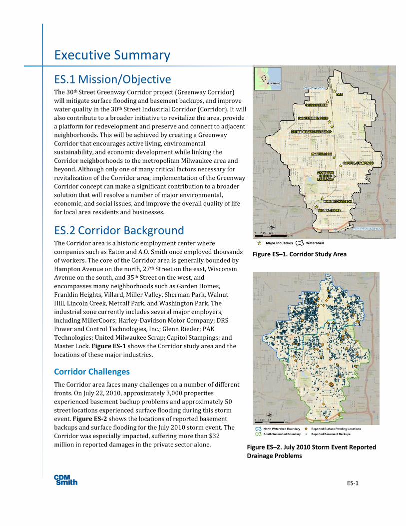
ES.2 Corridor Background The Corridor area is a historic employment center where
companies such as Eaton and A.O. Smith once employed thousands
of workers. The core of the Corridor area is generally bounded by
Hampton Avenue on the north, 27th Street on the east, Wisconsin
Avenue on the south, and 35th Street on the west, and
encompasses many neighborhoods such as Garden Homes,
Franklin Heights, Villard, Miller Valley, Sherman Park, Walnut
Hill, Lincoln Creek, Metcalf Park, and Washington Park. The
industrial zone currently includes several major employers,
including MillerCoors; Harley-Davidson Motor Company; DRS
Power and Control Technologies, Inc.; Glenn Rieder; PAK
Technologies; United Milwaukee Scrap; Capitol Stampings; and
Master Lock. Figure ES-1 shows the Corridor study area and the
locations of these major industries.
Corridor Challenges
The Corridor area faces many challenges on a number of different
fronts. On July 22, 2010, approximately 3,000 properties
experienced basement backup problems and approximately 50
street locations experienced surface flooding during this storm
event. Figure ES-2 shows the locations of reported basement
backups and surface flooding for the July 2010 storm event. The
Corridor was especially impacted, suffering more than $32
million in reported damages in the private sector alone.
Figure ES–1. Corridor Study Area
Figure ES–2. July 2010 Storm Event Reported Drainage Problems
Executive Summary
ES-2
Beyond the flooding problems, the Corridor faces significant social, environmental, and economic
challenges. Crime rates are high, which contributes to a decline in neighborhood desirability and a
disincentive for locating businesses in the area. Historic industrial use has left a legacy of contamination
with over 750 acres of brownfields in the Corridor. The collapse of the housing market in 2007 (CBSNEWS,
2012), has contributed to significant degradation in property values with significant properties vacant or in
foreclosure.
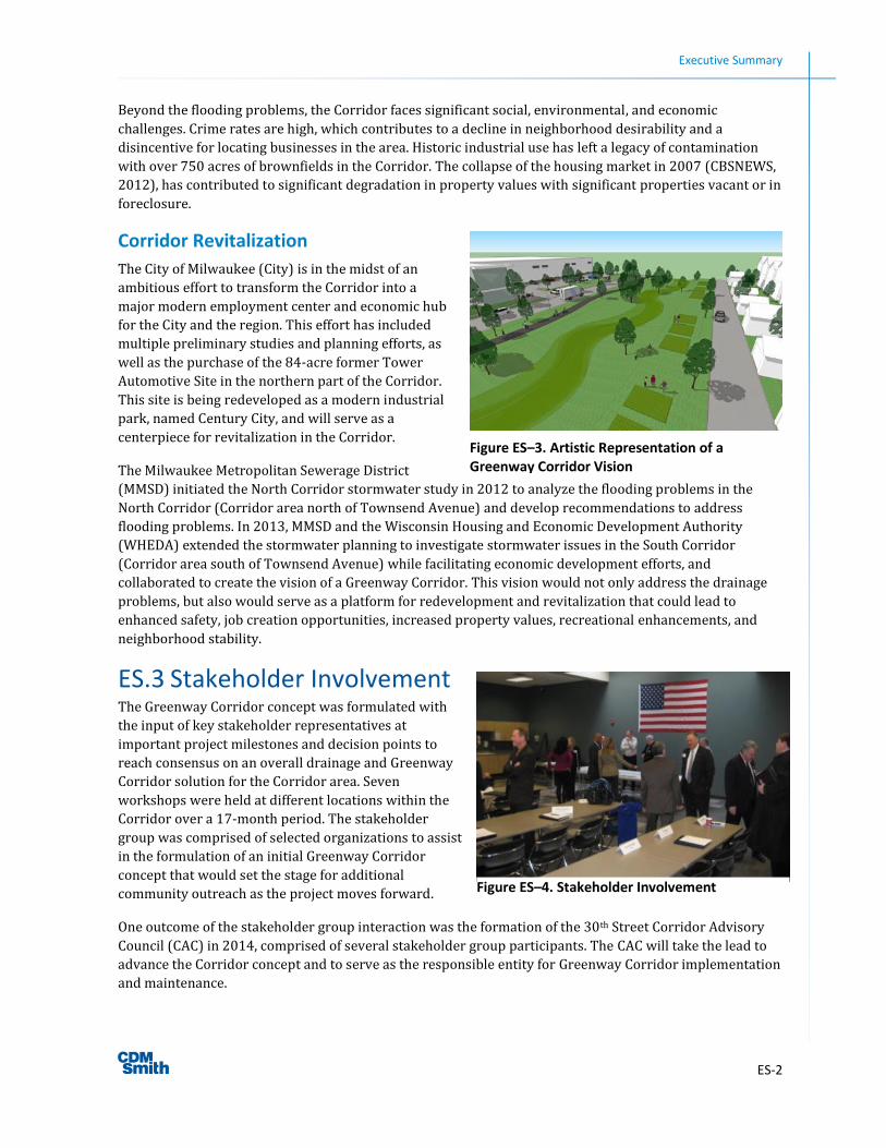
Corridor Revitalization
The City of Milwaukee (City) is in the midst of an
ambitious effort to transform the Corridor into a
major modern employment center and economic hub
for the City and the region. This effort has included
multiple preliminary studies and planning efforts, as
well as the purchase of the 84-acre former Tower
Automotive Site in the northern part of the Corridor.
This site is being redeveloped as a modern industrial
park, named Century City, and will serve as a
centerpiece for revitalization in the Corridor.
The Milwaukee Metropolitan Sewerage District
(MMSD) initiated the North Corridor stormwater study in 2012 to analyze the flooding problems in the
North Corridor (Corridor area north of Townsend Avenue) and develop recommendations to address
flooding problems. In 2013, MMSD and the Wisconsin Housing and Economic Development Authority
(WHEDA) extended the stormwater planning to investigate stormwater issues in the South Corridor
(Corridor area south of Townsend Avenue) while facilitating economic development efforts, and
collaborated to create the vision of a Greenway Corridor. This vision would not only address the drainage
problems, but also would serve as a platform for redevelopment and revitalization that could lead to
enhanced safety, job creation opportunities, increased property values, recreational enhancements, and
neighborhood stability.
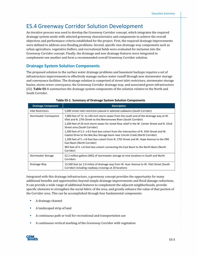
ES.3 Stakeholder Involvement The Greenway Corridor concept was formulated with
the input of key stakeholder representatives at
important project milestones and decision points to
reach consensus on an overall drainage and Greenway
Corridor solution for the Corridor area. Seven
workshops were held at different locations within the
Corridor over a 17-month period. The stakeholder
group was comprised of selected organizations to assist
in the formulation of an initial Greenway Corridor
concept that would set the stage for additional
community outreach as the project moves forward.
One outcome of the stakeholder group interaction was the formation of the 30th Street Corridor Advisory
Council (CAC) in 2014, comprised of several stakeholder group participants. The CAC will take the lead to
advance the Corridor concept and to serve as the responsible entity for Greenway Corridor implementation
and maintenance.
Figure ES–3. Artistic Representation of a Greenway Corridor Vision
Figure ES–4. Stakeholder Involvement
Executive Summary
ES-3
ES.4 Greenway Corridor Solution Development An iterative process was used to develop the Greenway Corridor concept, which integrates the required
drainage system needs with selected greenway characteristics and components to achieve the overall
objectives and performance criteria established for the project. First, the required drainage improvements
were defined to address area flooding problems. Second, specific non-drainage way components such as
urban agriculture, vegetative buffers, and recreational fields were evaluated for inclusion into the
Greenway Corridor concept. Finally, the drainage and non-drainage features were integrated to
complement one another and form a recommended overall Greenway Corridor solution.
Drainage System Solution Components
The proposed solution to the surface water drainage problems and basement backups requires a set of
infrastructure improvements to effectively manage surface water runoff through new stormwater storage
and conveyance facilities. The drainage solution is comprised of street inlet restrictors, stormwater storage
basins, storm sewer conveyance, the Greenway Corridor drainage way, and associated green infrastructure
(GI). Table ES-1 summarizes the drainage system components of the solution relative to the North and
South Corridor.
Table ES-1. Summary of Drainage System Solution Components
Drainage Component Description
Inlet Restrictors 5,000 street inlet restrictors placed in selected subbasins (South Corridor)
Stormwater Conveyance 7,000 feet of 72- to 144-inch storm sewer from the south end of the drainage way at W. Vliet and N. 27th Street to the Menomonee River (South Corridor)
2,200 feet of 24-inch storm sewer for street flow relief in the W. Center Street and N. 32nd Street area (South Corridor)
1,500 feet of 5.5- x 8.5-foot box culvert from the intersection of N. 35th Street and W. Capitol Drive to the Bee Bus Storage basin near Lincoln Creek (North Corridor)
1,200 feet of 5- x 8-foot box culvert from N. 27th Street and W. Hope Avenue to the DRS East Basin (North Corridor)
965 feet of 4- x 6-foot box culvert connecting the East Basin to the North Basin (North Corridor)
Stormwater Storage 52.2 million gallons (MG) of stormwater storage at nine locations in South and North Corridors
Drainage Way 13,500 feet (or 2.6 miles) of drainage way from W. Auer Avenue to W. Vliet Street (South Corridor) including roadway crossings at 20 locations
Integrated with this drainage infrastructure, a greenway concept provides the opportunity for many
additional benefits and opportunities beyond simple drainage improvements and flood damage reductions.
It can provide a wide range of additional features to complement the adjacent neighborhoods, provide
specific elements to strengthen the social fabric of the area, and greatly enhance the value of that portion of
the Corridor area. This can be accomplished through four fundamental components:
A drainage channel
A landscaped strip of land
A continuous path or trail for recreational and transportation use
A continuous vertical marking of the Greenway Corridor with vegetation
Executive Summary
ES-4
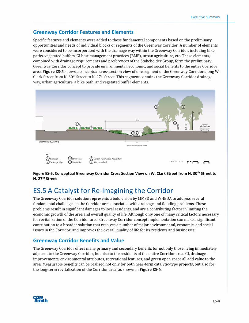
Greenway Corridor Features and Elements
Specific features and elements were added to these fundamental components based on the preliminary
opportunities and needs of individual blocks or segments of the Greenway Corridor. A number of elements
were considered to be incorporated with the drainage way within the Greenway Corridor, including bike
paths, vegetated buffers, GI best management practices (BMP), urban agriculture, etc. These elements,
combined with drainage requirements and preferences of the Stakeholder Group, form the preliminary
Greenway Corridor concept to provide environmental, economic, and social benefits to the entire Corridor
area. Figure ES-5 shows a conceptual cross section view of one segment of the Greenway Corridor along W.
Clark Street from N. 30th Street to N. 27th Street. This segment contains the Greenway Corridor drainage
way, urban agriculture, a bike path, and vegetated buffer elements.
Figure ES-5. Conceptual Greenway Corridor Cross Section View on W. Clark Street from N. 30th Street to N. 27th Street
ES.5 A Catalyst for Re-Imagining the Corridor The Greenway Corridor solution represents a bold vision by MMSD and WHEDA to address several
fundamental challenges in the Corridor area associated with drainage and flooding problems. These
problems result in significant damages to local residents, and are a contributing factor in limiting the
economic growth of the area and overall quality of life. Although only one of many critical factors necessary
for revitalization of the Corridor area, Greenway Corridor concept implementation can make a significant
contribution to a broader solution that resolves a number of major environmental, economic, and social
issues in the Corridor, and improves the overall quality of life for its residents and businesses.
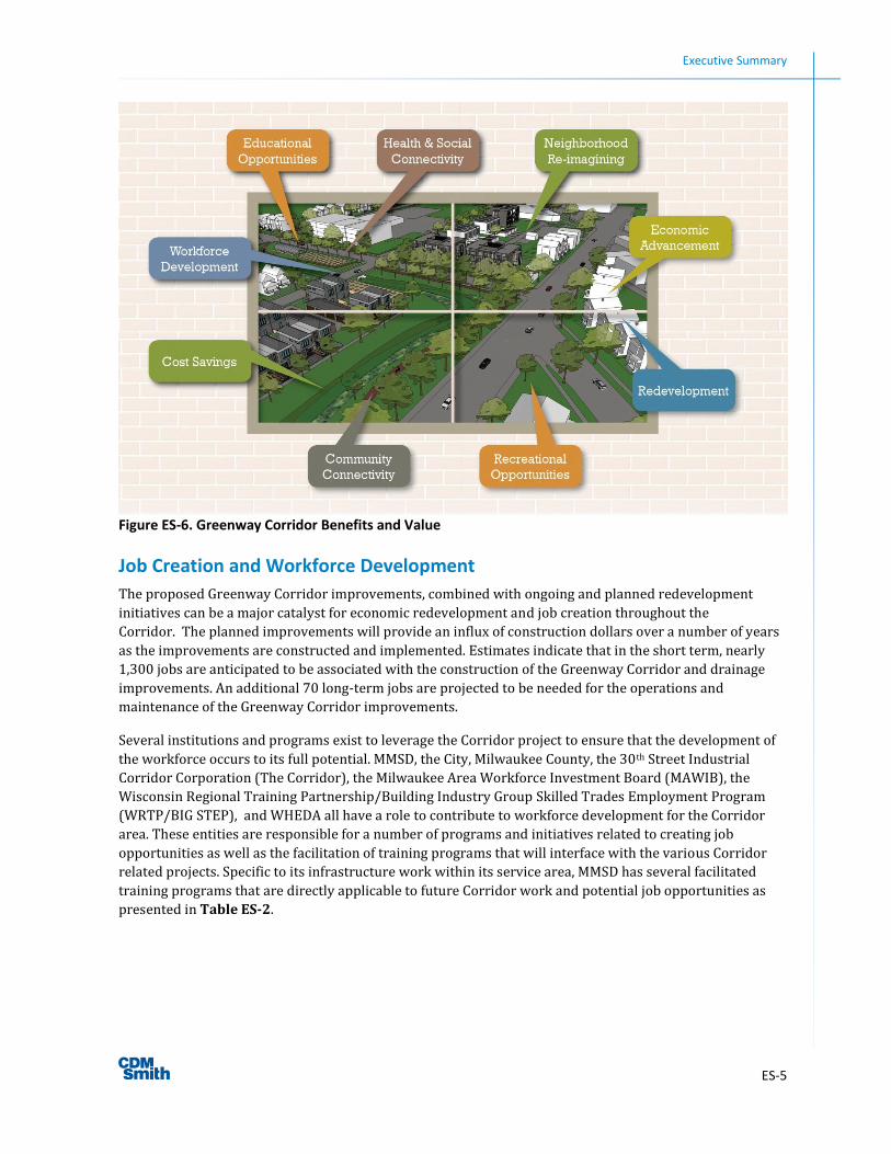
Greenway Corridor Benefits and Value
The Greenway Corridor offers many primary and secondary benefits for not only those living immediately
adjacent to the Greenway Corridor, but also to the residents of the entire Corridor area. GI, drainage
improvements, environmental attributes, recreational features, and green open space all add value to the
area. Measurable benefits can be realized not only for both near-term catalytic-type projects, but also for
the long-term revitalization of the Corridor area, as shown in Figure ES-6.
Executive Summary
ES-5
Figure ES-6. Greenway Corridor Benefits and Value
Job Creation and Workforce Development
The proposed Greenway Corridor improvements, combined with ongoing and planned redevelopment
initiatives can be a major catalyst for economic redevelopment and job creation throughout the
Corridor. The planned improvements will provide an influx of construction dollars over a number of years
as the improvements are constructed and implemented. Estimates indicate that in the short term, nearly
1,300 jobs are anticipated to be associated with the construction of the Greenway Corridor and drainage
improvements. An additional 70 long-term jobs are projected to be needed for the operations and
maintenance of the Greenway Corridor improvements.
Several institutions and programs exist to leverage the Corridor project to ensure that the development of
the workforce occurs to its full potential. MMSD, the City, Milwaukee County, the 30th Street Industrial
Corridor Corporation (The Corridor), the Milwaukee Area Workforce Investment Board (MAWIB), the
Wisconsin Regional Training Partnership/Building Industry Group Skilled Trades Employment Program
(WRTP/BIG STEP), and WHEDA all have a role to contribute to workforce development for the Corridor
area. These entities are responsible for a number of programs and initiatives related to creating job
opportunities as well as the facilitation of training programs that will interface with the various Corridor
related projects. Specific to its infrastructure work within its service area, MMSD has several facilitated
training programs that are directly applicable to future Corridor work and potential job opportunities as
presented in Table ES-2.
Executive Summary
ES-6
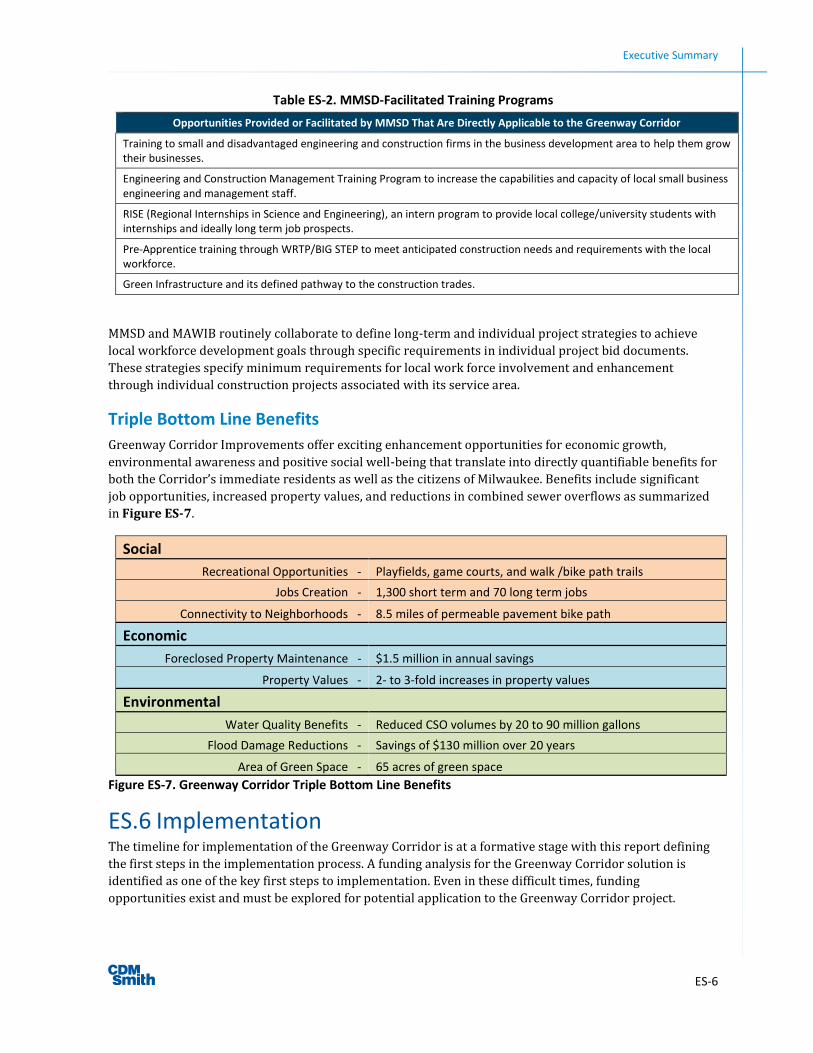
Table ES-2. MMSD-Facilitated Training Programs
Opportunities Provided or Facilitated by MMSD That Are Directly Applicable to the Greenway Corridor
Training to small and disadvantaged engineering and construction firms in the business development area to help them grow their businesses.
Engineering and Construction Management Training Program to increase the capabilities and capacity of local small business engineering and management staff.
RISE (Regional Internships in Science and Engineering), an intern program to provide local college/university students with internships and ideally long term job prospects.
Pre-Apprentice training through WRTP/BIG STEP to meet anticipated construction needs and requirements with the local workforce.
Green Infrastructure and its defined pathway to the construction trades.
MMSD and MAWIB routinely collaborate to define long-term and individual project strategies to achieve
local workforce development goals through specific requirements in individual project bid documents.
These strategies specify minimum requirements for local work force involvement and enhancement
through individual construction projects associated with its service area.
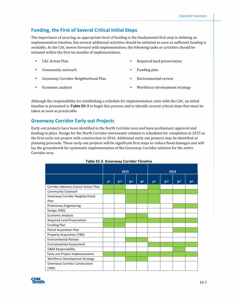
Triple Bottom Line Benefits
Greenway Corridor Improvements offer exciting enhancement opportunities for economic growth,
environmental awareness and positive social well-being that translate into directly quantifiable benefits for
both the Corridor’s immediate residents as well as the citizens of Milwaukee. Benefits include significant
job opportunities, increased property values, and reductions in combined sewer overflows as summarized
in Figure ES-7.
Social
Recreational Opportunities - Playfields, game courts, and walk /bike path trails
Jobs Creation - 1,300 short term and 70 long term jobs
Connectivity to Neighborhoods - 8.5 miles of permeable pavement bike path
Economic
Foreclosed Property Maintenance - $1.5 million in annual savings
Property Values - 2- to 3-fold increases in property values
Environmental
Water Quality Benefits - Reduced CSO volumes by 20 to 90 million gallons
Flood Damage Reductions - Savings of $130 million over 20 years
Area of Green Space - 65 acres of green space
Figure ES-7. Greenway Corridor Triple Bottom Line Benefits
ES.6 Implementation The timeline for implementation of the Greenway Corridor is at a formative stage with this report defining
the first steps in the implementation process. A funding analysis for the Greenway Corridor solution is
identified as one of the key first steps to implementation. Even in these difficult times, funding
opportunities exist and must be explored for potential application to the Greenway Corridor project.
Executive Summary
ES-7
Funding, the First of Several Critical Initial Steps
The importance of securing an appropriate level of funding is the fundamental first step in defining an
implementation timeline, but several additional activities should be initiated as soon as sufficient funding is
available. As the CAC moves forward with implementation, the following tasks or activities should be
initiated within the first six months of implementation:
CAC Action Plan
Community outreach
Greenway Corridor Neighborhood Plan
Economic analysis
Required land preservation
Funding plan
Environmental review
Workforce development strategy
Although the responsibility for establishing a schedule for implementation rests with the CAC, an initial
timeline is presented in Table ES-3 to begin this process and to identify several critical steps that must be
taken as soon as practicable.
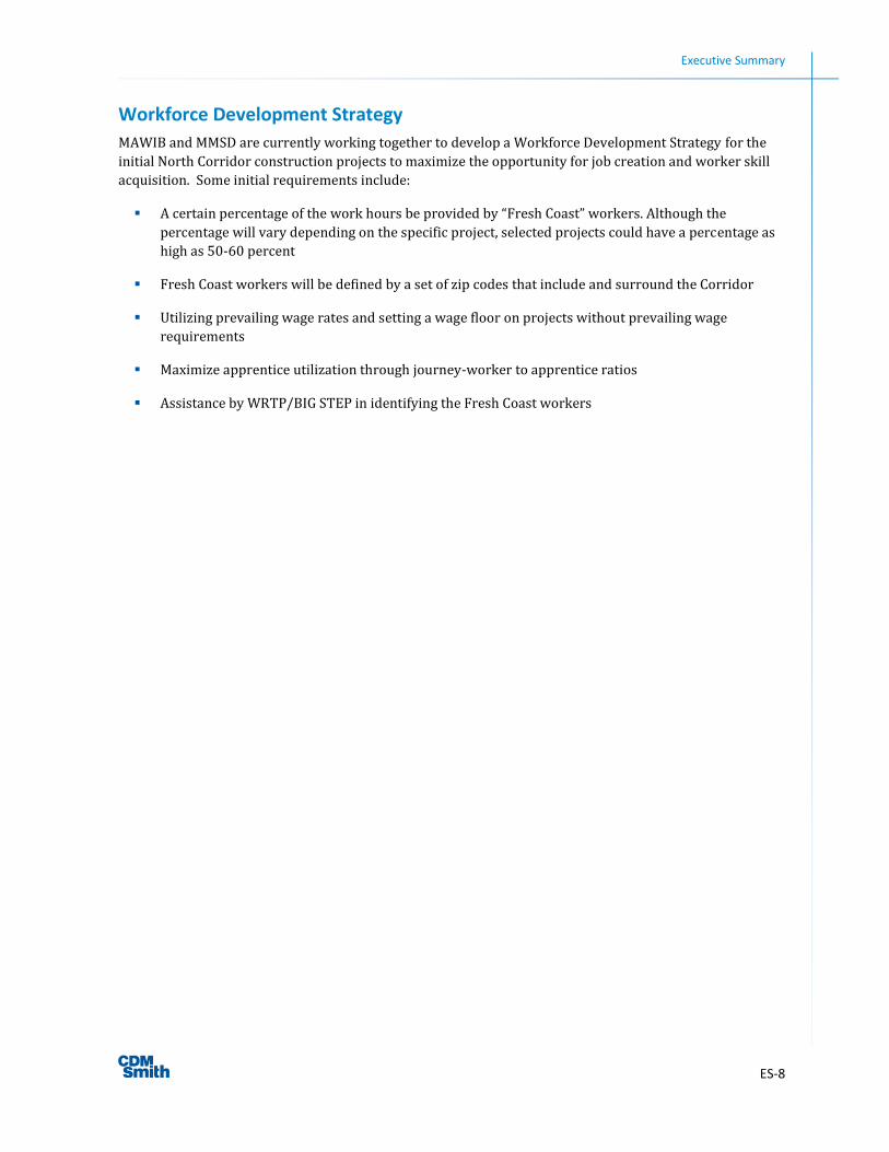
Greenway Corridor Early-out Projects
Early-out projects have been identified in the North Corridor area and have preliminary approval and
funding in place. Design for the North Corridor stormwater solution is scheduled for completion in 2015 as
the first early-out project with construction in 2016. Additional early-out projects may be identified as
planning proceeds. These early-out projects will be significant first steps to reduce flood damages and will
lay the groundwork for systematic implementation of the Greenway Corridor solution for the entire
Corridor area.
Table ES-3. Greenway Corridor Timeline
2015 2016
1st 2nd 3rd 4th 1st 2nd 3rd 4th
Corridor Advisory Council Action Plan
Community Outreach
Greenway Corridor Neighborhood
Plan
Preliminary Engineering
Design (TBD)
Economic Analysis
Required Land Preservation
Funding Plan
Parcel Acquisition Plan
Property Acquisition (TBD)
Environmental Review
Environmental Assessment
O&M Responsibility
Early-out Project Implementation
Workforce Development Strategy
Greenway Corridor Construction
(TBD)
Executive Summary
ES-8
Workforce Development Strategy
MAWIB and MMSD are currently working together to develop a Workforce Development Strategy for the
initial North Corridor construction projects to maximize the opportunity for job creation and worker skill
acquisition. Some initial requirements include:
A certain percentage of the work hours be provided by “Fresh Coast” workers. Although the
percentage will vary depending on the specific project, selected projects could have a percentage as
high as 50-60 percent
Fresh Coast workers will be defined by a set of zip codes that include and surround the Corridor
Utilizing prevailing wage rates and setting a wage floor on projects without prevailing wage
requirements
Maximize apprentice utilization through journey-worker to apprentice ratios
Assistance by WRTP/BIG STEP in identifying the Fresh Coast workers
1-1
Section 1 Introduction
1.1 Background and Objectives 1.1.1 Background
The 30th Street Industrial Corridor (Corridor) is located in the City of Milwaukee (City), northwest of
downtown. The Corridor is an older section of the City that was originally developed in the period from the
late 1880’s to the 1920’s. While the area is largely residential, there is a strip of concentrated industrial
land use several blocks wide that follows the Canadian Pacific Railroad along the entire north-south extent
of the Corridor. Several of Milwaukee’s most prominent employers are located along this industrial strip
including DRS Power & Control Technologies, United Milwaukee Scrap, Master Lock, MillerCoors, and
Harley-Davidson.
The Corridor area has experienced a continuous decline during the past few decades with a significant
number of industries leaving the City. The area was hard hit by the recession from 2007 to 2009 and
continues to experience problems associated with abandoned properties and foreclosures. The Corridor
area is one of the most economically depressed areas of the City facing numerous challenges related to
declining property values, high crime, and persistent unemployment. The area experiences widespread
basement backup problems, surface ponding and associated flood damages during major rainfall events.
The City has been working with local, state and federal partners to redevelop the Corridor, moving forward
on a number of initiatives, similar to the efforts that led into the revitalization of the Menomonee Valley. In
2012, Governor Scott Walker and the Wisconsin Housing and Economic Development Authority (WHEDA)
unveiled Transform Milwaukee, a historic and comprehensive initiative aimed at growing the economy in
the City. The Milwaukee Metropolitan Sewerage District (MMSD) initiated Corridor stormwater studies to
analyze the flooding problems and develop recommendations to minimize the flooding and resulting
property damage. In 2013, MMSD and WHEDA collaborated to create a vision of a 30th Street Greenway
Corridor project (Greenway Corridor).
1.1.2 Mission
The Greenway Corridor project will mitigate surface flooding and basement backups, and improve water
quality in the Corridor. It will also contribute to a broader initiative to revitalize the area, provide a
platform for redevelopment, and preserve and connect adjacent neighborhoods. This outcome will be
achieved by creating a Greenway Corridor that encourages active living, environmental sustainability, and
economic development while linking many neighborhoods of the Corridor to the metropolitan Milwaukee
area and beyond.
Two companion projects—the 30th Street Corridor Stormwater Study-North Section planning report and
the 30th Street Corridor Stormwater Study-South Section planning report (North and South Corridor
Reports)—provided the technical basis for the drainage way development, the core of the Greenway
Corridor project. The Greenway Corridor is one component of Transform Milwaukee, a public-private
partnership focusing on restoring economic prosperity to the industrial, residential, and transportation
areas connecting the City Industrial Corridor, Menomonee Valley, Port of Milwaukee, and the Aerotropolis.
The primary strategies for Transform Milwaukee are:
Expand business development and innovation with new and existing financing resources to spur job
creation
Section 1 Introduction
1-2
Reduce the number of foreclosed and vacant properties to make neighborhoods more desirable for
housing and business development
Foster partnerships between state agencies and nonprofit community groups to increase job
training, skill enhancement and educational opportunities
Create stormwater runoff conveyance systemsbioswalesas an alternative to storm sewers to
reduce future flooding events
Direct resources to established intermodal transportation infrastructurewater, air, rail and
highway systems
1.1.3 Objectives
The Greenway Corridor project must accomplish a number of primary and secondary objectives to achieve
its overall mission. These objectives must be integrated together to produce a result that improves the
environmental, social, and economic well-being of the Corridor area. They must also complement other
parallel initiatives geared to improve the quality of life in the Corridor. Primary objectives include:
Mitigating surface flooding, basement backups, and associated damages
Linking neighborhoods together along and across the proposed Greenway Corridor
Improving surface runoff water quality
Bolstering property values by making the Greenway Corridor available for use by residents, area
workers, and visitors
Establishing the foundation for new economic growth and associated job creation
Secondary objectives include:
Connecting the Greenway Corridor to the larger network of trails and environmental corridors in the
Milwaukee area
Developing an aesthetically pleasing, linear greenway system
Providing opportunities for environmental education to be conducted along the Greenway Corridor
Creating the potential for active recreation for health and well being
Establishing places for residents to gather, meet, and socialize
Implementing Crime Prevention Through Environmental Design (CPTED) standards
Establishing community garden areas for residents to grow their own produce and reduce the food
desert along the Corridor area
These above mentioned primary and secondary objectives complement the City, MMSD and WHEDA goals.
1.1.4 Project Partners and Stakeholder Involvement
The Greenway Corridor project is a joint effort led by MMSD and WHEDA in collaboration with the 30th
Street Industrial Corridor Corporation (Corridor Corporation) and the City. These agencies formed the core
of the Greenway Corridor team to foster the Greenway Corridor initiative, facilitating the participation of a
Section 1 Introduction
1-3
number of other agencies and interested parties to create the vision for the project. Collaboration and
facilitation efforts included a series of meetings with the Stakeholder Group; special meetings with
interested local, state, and federal agencies; and the formation of a Greenway Corridor Advisory Council to
assist in this initiative.
Stakeholder Group
A stakeholder involvement plan was implemented for the Greenway Corridor to facilitate regular
interaction with stakeholder representatives, to obtain their input at key project milestones and decisions,
and to reach consensus on an overall drainage and Greenway Corridor solution. Seven workshops were
held at different locations within the Corridor over a 17-month period. The stakeholder group was
represented by selected organizations that could contribute to the formulation of an initial Greenway
Corridor concept that would set the stage for additional community outreach in the next phase of the
project. Stakeholder group representation included, but was not limited to, the Corridor Corporation,
Wisconsin Department of Natural Resources (WDNR), the City, and local businesses such as Harley-
Davidson. Table 1-1 lists the stakeholder group representatives for the Greenway Corridor.
Table 1-1. Project Stakeholder Representatives
Harley-Davidson Milwaukee Metropolitan Sewerage District
Master Lock Wisconsin Housing and Economic Development Authority
Menomonee Valley Partners Milwaukee Department of City Development (DCD)
Capitol Stampings Wisconsin Department of Natural Resources (WDNR)
United Milwaukee Scrap Milwaukee Department of Public Works (DPW)
Washington Park Partners Merrill Park Neighborhood Association
30th Street Industrial Corridor Corporation University of Wisconsin-Milwaukee
Lisbon Avenue Neighborhood Development Children’s Environmental Health Sciences Core Center
Citizens near Corridor Area JONCO Industries
DRS Technologies Milwaukee Area Workforce Investment Board (MAWIB)
Coalition for Hope Blockwatch
Special Agency Collaboration Meetings
Two special meetings were held with a broader group of agencies and other parties to present the
Greenway Corridor concept, discuss the overarching Corridor vision, identify funding opportunities and
program synergies, and initiate potential partnerships. These meetings were held on January 10th and
September 16th, 2013 and included the participation of the agencies shown in Table 1-2.
Section 1 Introduction
1-4
Table 1-2. Local, State and Federal Agencies
30th Street Industrial Corridor Corporation Milwaukee Metropolitan Sewerage District
Agency for Toxic Substances and Disease Registry Milwaukee Office of Environmental Sustainability
City of Milwaukee-Department of Public Works Northwest Side Community Development Corporation
City of Milwaukee-Department Of Administration-Intergovernmental Relations Division
Congresswoman Gwen Moore (Wisconsin’s 4th District)
City of Milwaukee-Redevelopment Authority of the City of Milwaukee U.S. Senator Ron Johnson
Wisconsin Coastal Management Program Southeastern Wisconsin Regional Planning Commission
Corporation for National and Community Service U.S. Department of Labor-Office of Federal Contract Compliance Programs
Department of Commerce-Economic Development Administration U.S. Department of Labor
Federal Transit Administration U.S. Environmental Protection Agency-Region V
General Services Administration-Chicago U.S. Housing Urban Development
Department of Housing and Urban Development -Chicago University of Wisconsin-Milwaukee
Milwaukee Education Partnership Wisconsin Department of Children & Families
Wisconsin Department of Natural Resources Wisconsin Housing and Economic Development Authority Wisconsin Department of Transportation
Corridor Advisory Council
On January 9th, 2014, MMSD brought together the Corridor Advisory Council (CAC), which is comprised of
a number of partners whose work is engaged in or is influential to the Corridor area, including
representatives from the City, faith-based groups, neighborhood representatives, financial agencies, and
nonprofit organizations. Membership of the CAC includes:
Milwaukee Metropolitan Sewerage
District
Wisconsin Housing and Economic
Development Authority
City of Milwaukee – Department of Public
Works
City of Milwaukee – Department of City
Development
30th Street Industrial Corridor Corporation
Milwaukee Pastors Strategy Group
Department of Housing and Urban
Development
1000 Friends of Wisconsin
American Rivers
Clean Wisconsin
Holy Cathedral / Word of Hope
Jabez Church
Milwaukee Inner-City Congregations Allied for
Hope
Milwaukee Area Workforce Investment Board
Milwaukee County
New Hope Missionary Baptist Church
Northwest Side Community Development
Corporation
Sixteenth Street Community Health Center
Trust for Public Land (TPL)
Uniting Garden Home, Inc.
Urban League
Victory Garden Initiative
This advisory group was assembled to discuss ongoing efforts in the Corridor and develop strong
partnerships for moving forward. The group will meet periodically as detailed plans and activities are
identified, and will facilitate the transition to funding and implementation of the Corridor improvements.
Section 1 Introduction
1-5
1.2 Corridor Description As a major component of Milwaukee’s economic engine, the Corridor experienced an extended period of
growth and development. However, the downturn in American heavy industry in the late 20th century
directly impacted the Corridor, contributing to its decline in industrial output, economic opportunities, and
property values. These declines have led to broader social impacts that include job loss and unemployment,
foreclosures, and increases in crime. Infrastructure limitations in the area have resulted in surface drainage
problems and basement backups, contributing to further reductions in property values and economic
opportunities for the area. These problems are a major factor in the overall decline of the Corridor and have
established a critical need for revitalization of its neighborhoods and re-creation of economic opportunities
for its residents—fundamental objectives for the Greenway Corridor project.
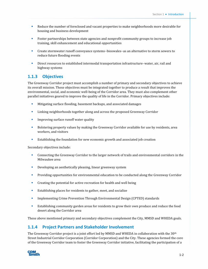
1.2.1 Corridor History
In the last half of the nineteenth century, the
discovery of iron ore in Dodge County fueled
Milwaukee’s steel, iron, and manufacturing
industries. In response, the Corridor area sprang
up along the railroad lines from W. Hampton to
W. Highland Avenues and N. 27th to N. 35th
Streets. Much of the Corridor area developed to
transform raw materials into finished products
along a central rail line through the center of it.
Over the last quarter of the 20th century, the
Corridor area’s economic wellbeing depended on
the vitality of its manufacturing sector, spurring
growth as stable blue-collar neighborhoods, as well
as satellite suppliers and specialty shops.
MillerCoors, which anchors the south end of the
Corridor area, grew from the dreams of a German
entrepreneur, Frederick Miller, who came to
America in the mid-19th Century. Miller Brewing
Company was founded in 1855 when Miller
purchased the small Plank Road Brewery. The
brewery’s location in the City’s Menomonee Valley
provided easy access to raw materials produced on
nearby farms, with the small brewery expanding
into the current facility that exists today.
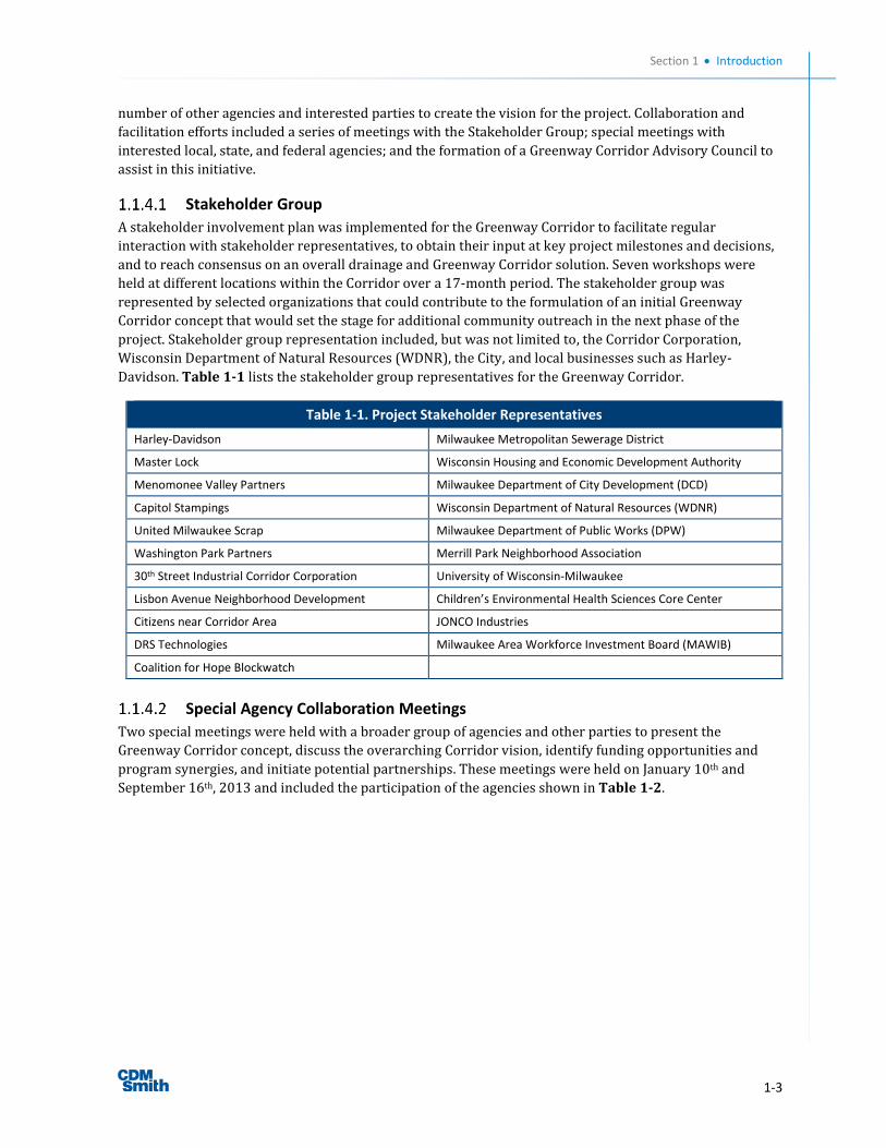
The largest of the manufacturing companies in the
Corridor area was A.O. Smith, located along W.
Hopkins Avenue from N. 27th Street to W. Capitol
Drive. Founded in 1874 as a parts maker for baby
carriages, A.O. Smith expanded its operations to
bicycle frames and then to pressed steel car frames
in 1899. In 1904, A.O. Smith dominated the
neighborhood in both size and employment. At its
peak, 10,000 local residents were employed by A.O. Smith at its 84-acre complex.
Figure 1-1. MillerCoors Facility
Figure 1-2. Harley-Davidson Works in 1911
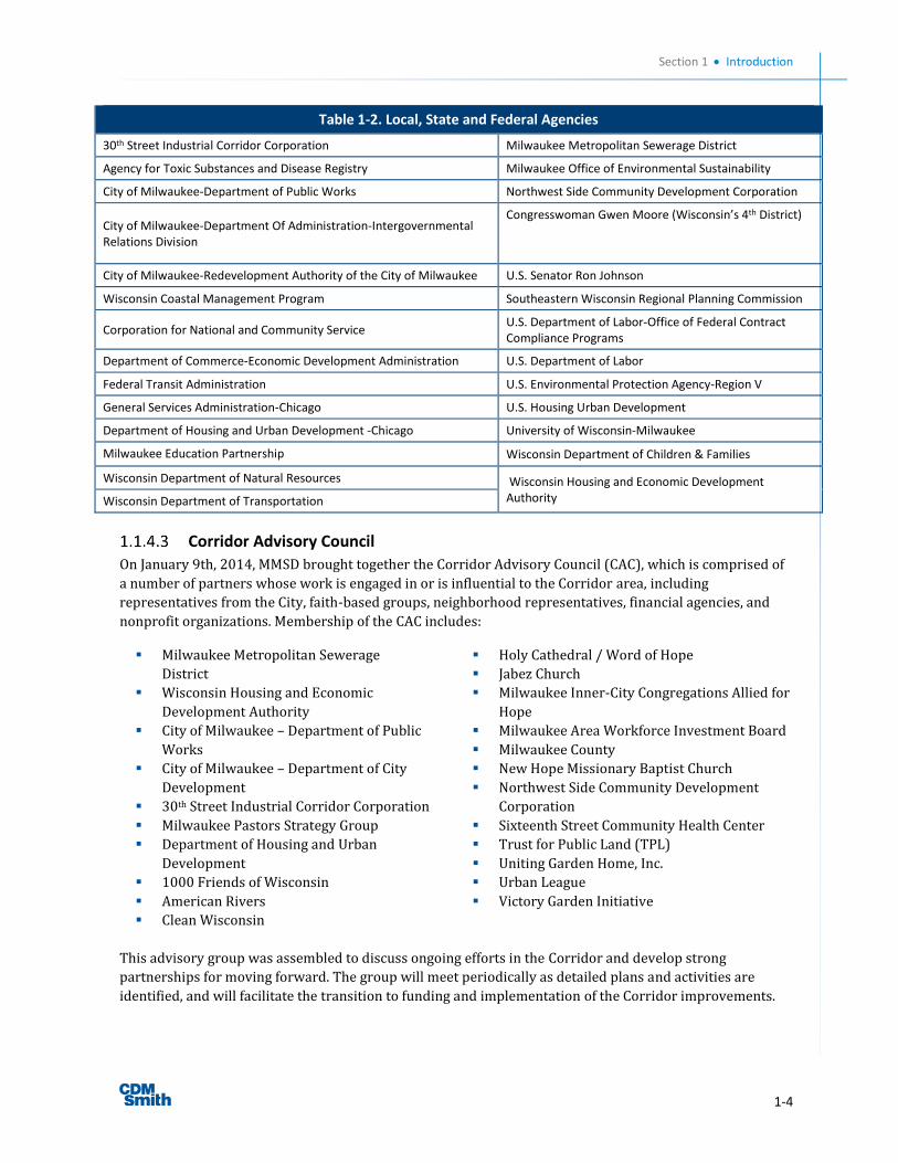
Figure 1-3. Esser Paint Building and Railroad Tracks
Section 1 Introduction
1-6
In 1906, the Harley and Davidson brothers built their
first factory on W. Chestnut Street (later Juneau
Avenue), and the location remains as Harley-
Davidson’s corporate headquarters. In 1910, the
factory, with its many additions, took up two blocks
along W. Juneau Avenue and around the corner of N.
38th Street. By the early 20th century, other important
companies began manufacturing businesses in the
Corridor, including Master Lock, Esser Paint, and
Steeltech Manufacturing.
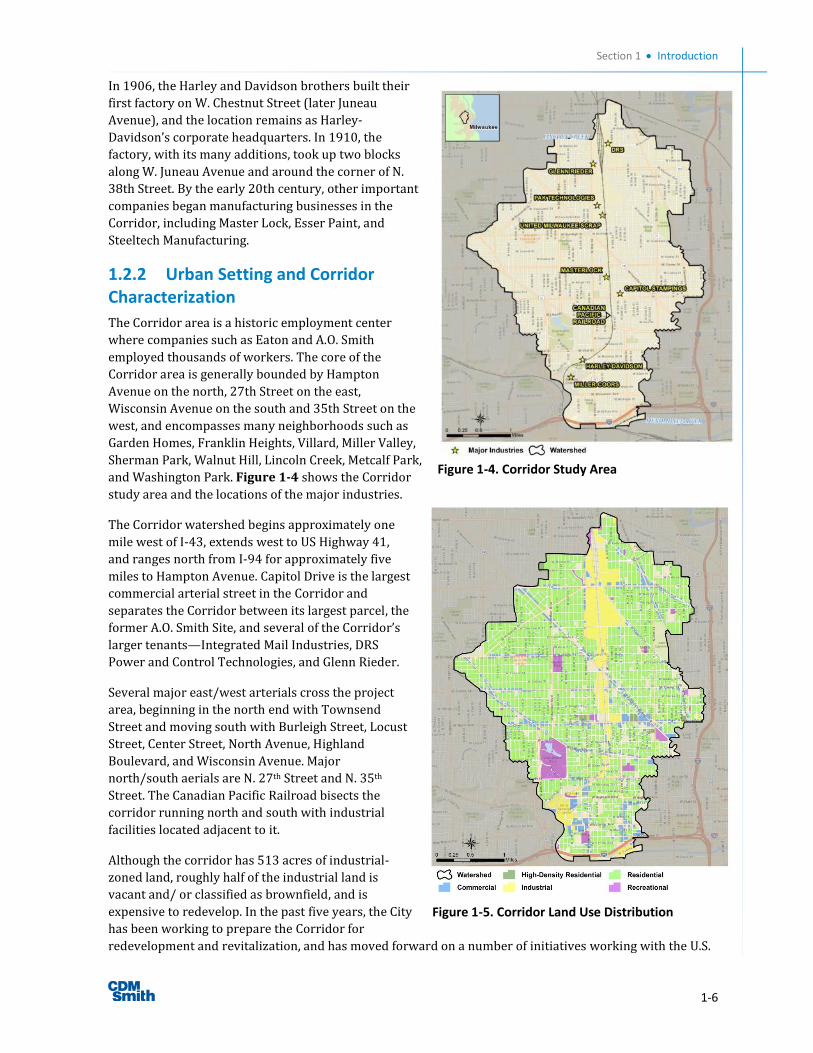
1.2.2 Urban Setting and Corridor Characterization
The Corridor area is a historic employment center
where companies such as Eaton and A.O. Smith
employed thousands of workers. The core of the
Corridor area is generally bounded by Hampton
Avenue on the north, 27th Street on the east,
Wisconsin Avenue on the south and 35th Street on the
west, and encompasses many neighborhoods such as
Garden Homes, Franklin Heights, Villard, Miller Valley,
Sherman Park, Walnut Hill, Lincoln Creek, Metcalf Park,
and Washington Park. Figure 1-4 shows the Corridor
study area and the locations of the major industries.
The Corridor watershed begins approximately one
mile west of I-43, extends west to US Highway 41,
and ranges north from I-94 for approximately five
miles to Hampton Avenue. Capitol Drive is the largest
commercial arterial street in the Corridor and
separates the Corridor between its largest parcel, the
former A.O. Smith Site, and several of the Corridor’s
larger tenants—Integrated Mail Industries, DRS
Power and Control Technologies, and Glenn Rieder.
Several major east/west arterials cross the project
area, beginning in the north end with Townsend
Street and moving south with Burleigh Street, Locust
Street, Center Street, North Avenue, Highland
Boulevard, and Wisconsin Avenue. Major
north/south aerials are N. 27th Street and N. 35th
Street. The Canadian Pacific Railroad bisects the
corridor running north and south with industrial
facilities located adjacent to it.
Although the corridor has 513 acres of industrial-
zoned land, roughly half of the industrial land is
vacant and/ or classified as brownfield, and is
expensive to redevelop. In the past five years, the City
has been working to prepare the Corridor for
redevelopment and revitalization, and has moved forward on a number of initiatives working with the U.S.
Figure 1-4. Corridor Study Area
Figure 1-5. Corridor Land Use Distribution
Section 1 Introduction
1-7
Environmental Protection Agency (EPA) to mitigate brownfields; however, there are additional challenges
that still need to be addressed.
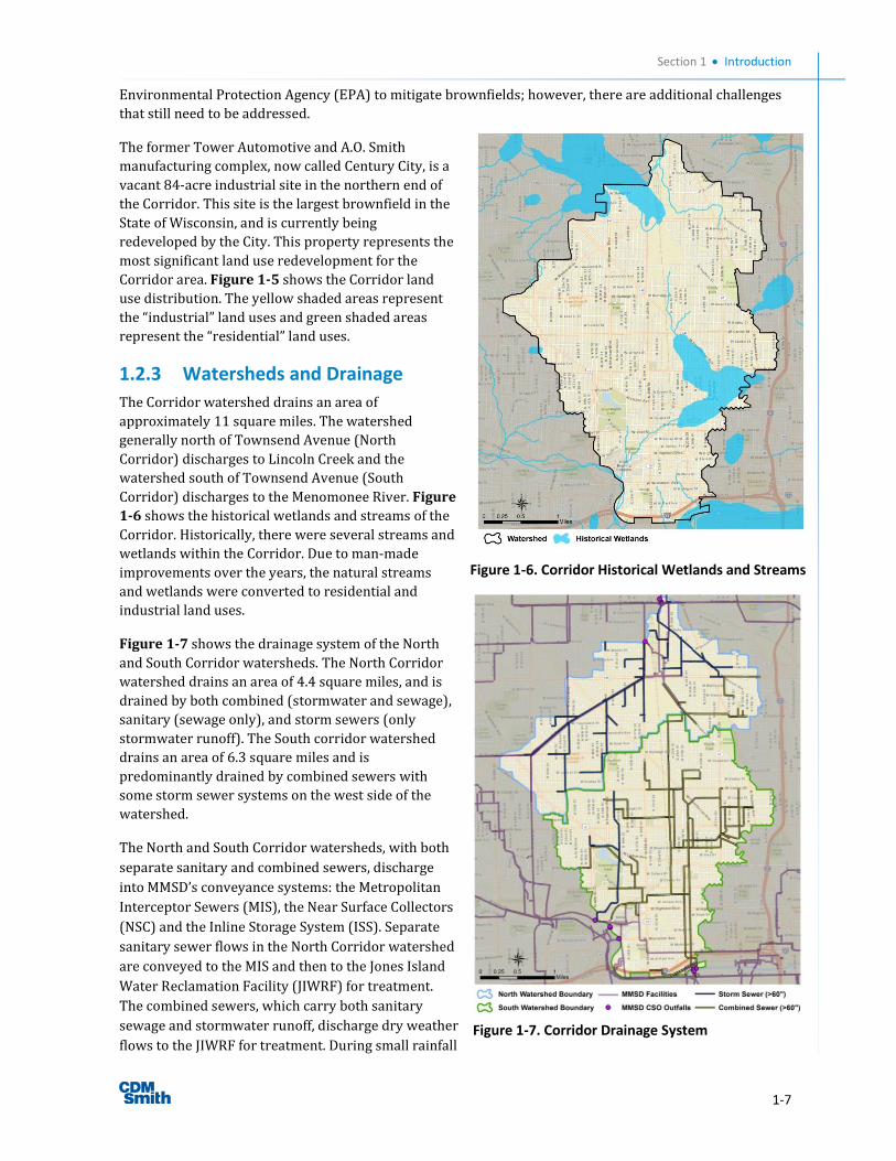
The former Tower Automotive and A.O. Smith
manufacturing complex, now called Century City, is a
vacant 84-acre industrial site in the northern end of
the Corridor. This site is the largest brownfield in the
State of Wisconsin, and is currently being
redeveloped by the City. This property represents the
most significant land use redevelopment for the
Corridor area. Figure 1-5 shows the Corridor land
use distribution. The yellow shaded areas represent
the “industrial” land uses and green shaded areas
represent the “residential” land uses.
1.2.3 Watersheds and Drainage
The Corridor watershed drains an area of
approximately 11 square miles. The watershed
generally north of Townsend Avenue (North
Corridor) discharges to Lincoln Creek and the
watershed south of Townsend Avenue (South
Corridor) discharges to the Menomonee River. Figure
1-6 shows the historical wetlands and streams of the
Corridor. Historically, there were several streams and
wetlands within the Corridor. Due to man-made
improvements over the years, the natural streams
and wetlands were converted to residential and
industrial land uses.
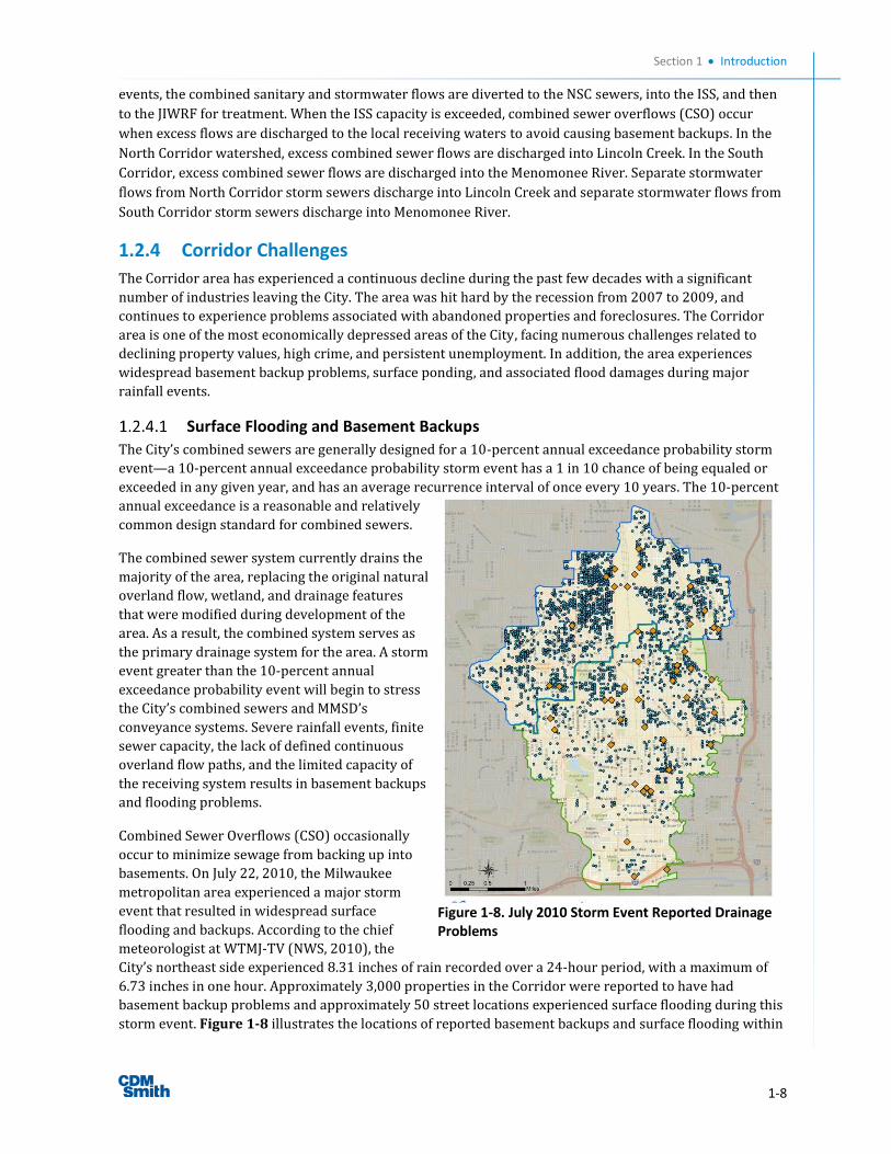
Figure 1-7 shows the drainage system of the North
and South Corridor watersheds. The North Corridor
watershed drains an area of 4.4 square miles, and is
drained by both combined (stormwater and sewage),
sanitary (sewage only), and storm sewers (only
stormwater runoff). The South corridor watershed
drains an area of 6.3 square miles and is
predominantly drained by combined sewers with
some storm sewer systems on the west side of the
watershed.
The North and South Corridor watersheds, with both
separate sanitary and combined sewers, discharge
into MMSD’s conveyance systems: the Metropolitan
Interceptor Sewers (MIS), the Near Surface Collectors
(NSC) and the Inline Storage System (ISS). Separate
sanitary sewer flows in the North Corridor watershed
are conveyed to the MIS and then to the Jones Island
Water Reclamation Facility (JIWRF) for treatment.
The combined sewers, which carry both sanitary
sewage and stormwater runoff, discharge dry weather
flows to the JIWRF for treatment. During small rainfall Figure 1-7. Corridor Drainage System
Figure 1-6. Corridor Historical Wetlands and Streams
Section 1 Introduction
1-8
events, the combined sanitary and stormwater flows are diverted to the NSC sewers, into the ISS, and then
to the JIWRF for treatment. When the ISS capacity is exceeded, combined sewer overflows (CSO) occur
when excess flows are discharged to the local receiving waters to avoid causing basement backups. In the
North Corridor watershed, excess combined sewer flows are discharged into Lincoln Creek. In the South
Corridor, excess combined sewer flows are discharged into the Menomonee River. Separate stormwater
flows from North Corridor storm sewers discharge into Lincoln Creek and separate stormwater flows from
South Corridor storm sewers discharge into Menomonee River.
1.2.4 Corridor Challenges
The Corridor area has experienced a continuous decline during the past few decades with a significant
number of industries leaving the City. The area was hit hard by the recession from 2007 to 2009, and
continues to experience problems associated with abandoned properties and foreclosures. The Corridor
area is one of the most economically depressed areas of the City, facing numerous challenges related to
declining property values, high crime, and persistent unemployment. In addition, the area experiences
widespread basement backup problems, surface ponding, and associated flood damages during major
rainfall events.
Surface Flooding and Basement Backups
The City’s combined sewers are generally designed for a 10-percent annual exceedance probability storm
event—a 10-percent annual exceedance probability storm event has a 1 in 10 chance of being equaled or
exceeded in any given year, and has an average recurrence interval of once every 10 years. The 10-percent
annual exceedance is a reasonable and relatively
common design standard for combined sewers.
The combined sewer system currently drains the
majority of the area, replacing the original natural
overland flow, wetland, and drainage features
that were modified during development of the
area. As a result, the combined system serves as
the primary drainage system for the area. A storm
event greater than the 10-percent annual
exceedance probability event will begin to stress
the City’s combined sewers and MMSD’s
conveyance systems. Severe rainfall events, finite
sewer capacity, the lack of defined continuous
overland flow paths, and the limited capacity of
the receiving system results in basement backups
and flooding problems.
Combined Sewer Overflows (CSO) occasionally
occur to minimize sewage from backing up into
basements. On July 22, 2010, the Milwaukee
metropolitan area experienced a major storm
event that resulted in widespread surface
flooding and backups. According to the chief
meteorologist at WTMJ-TV (NWS, 2010), the
City’s northeast side experienced 8.31 inches of rain recorded over a 24-hour period, with a maximum of
6.73 inches in one hour. Approximately 3,000 properties in the Corridor were reported to have had
basement backup problems and approximately 50 street locations experienced surface flooding during this
storm event. Figure 1-8 illustrates the locations of reported basement backups and surface flooding within
Figure 1-8. July 2010 Storm Event Reported Drainage Problems
Section 1 Introduction
1-9
the Corridor for the July 2010 storm event. Private sector damages in the Corridor alone exceeded $32
million. The proposed Greenway Corridor will significantly reduce these surface flooding and basement
backups in the Corridor.
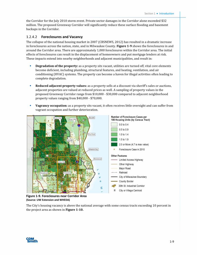
Foreclosures and Vacancy
The collapse of the national housing market in 2007 (CBSNEWS, 2012) has resulted in a dramatic increase
in foreclosures across the nation, state, and in Milwaukee County. Figure 1-9 shows the foreclosures in and
around the Corridor area. There are approximately 1,000 foreclosures within the Corridor area. The initial
effects of foreclosures can result in the displacement of homeowners and put mortgage lenders at risk.
These impacts extend into nearby neighborhoods and adjacent municipalities, and result in:
Degradation of the property: as a property sits vacant, utilities are turned off, vital core elements
become deficient, including plumbing, structural features, and heating, ventilation, and air
conditioning (HVAC) systems. The property can become a haven for illegal activities often leading to
complete degradation.
Reduced adjacent property values: as a property sells at a discount via sheriff’s sales or auctions,
adjacent properties are valued at reduced prices as well. A sampling of property values in the
proposed Greenway Corridor range from $10,000 - $30,000 compared to adjacent neighborhood
property values ranging from $40,000 - $70,000.
Vagrancy occupation: as a property sits vacant, it often receives little oversight and can suffer from
vagrant occupation and further deterioration.
Figure 1-9. Foreclosures near Corridor Area
(Source: UW Extension and WHEDA)
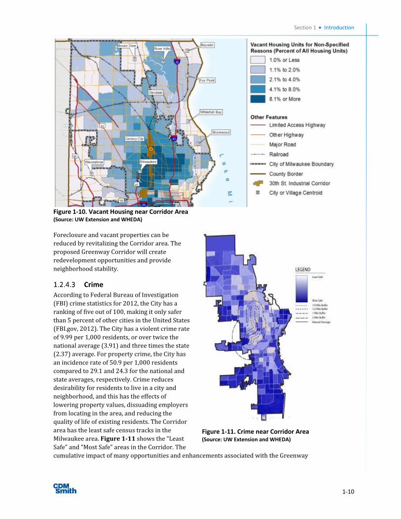
The City’s housing vacancy is above the national average with some census tracts exceeding 10 percent in
the project area as shown in Figure 1-10.
Section 1 Introduction
1-10
Figure 1-10. Vacant Housing near Corridor Area (Source: UW Extension and WHEDA)
Foreclosure and vacant properties can be
reduced by revitalizing the Corridor area. The
proposed Greenway Corridor will create
redevelopment opportunities and provide
neighborhood stability.
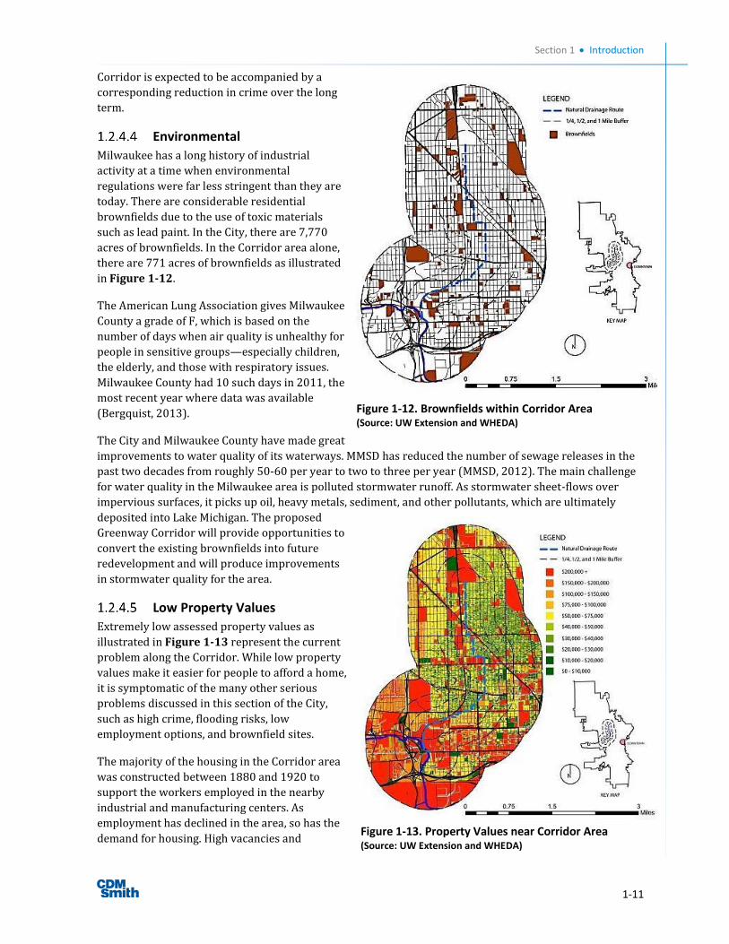
Crime
According to Federal Bureau of Investigation
(FBI) crime statistics for 2012, the City has a
ranking of five out of 100, making it only safer
than 5 percent of other cities in the United States
(FBI.gov, 2012). The City has a violent crime rate
of 9.99 per 1,000 residents, or over twice the
national average (3.91) and three times the state
(2.37) average. For property crime, the City has
an incidence rate of 50.9 per 1,000 residents
compared to 29.1 and 24.3 for the national and
state averages, respectively. Crime reduces
desirability for residents to live in a city and
neighborhood, and this has the effects of
lowering property values, dissuading employers
from locating in the area, and reducing the
quality of life of existing residents. The Corridor
area has the least safe census tracks in the
Milwaukee area. Figure 1-11 shows the “Least
Safe” and “Most Safe” areas in the Corridor. The
cumulative impact of many opportunities and enhancements associated with the Greenway
Figure 1-11. Crime near Corridor Area (Source: UW Extension and WHEDA)
Section 1 Introduction
1-11
Corridor is expected to be accompanied by a
corresponding reduction in crime over the long
term.
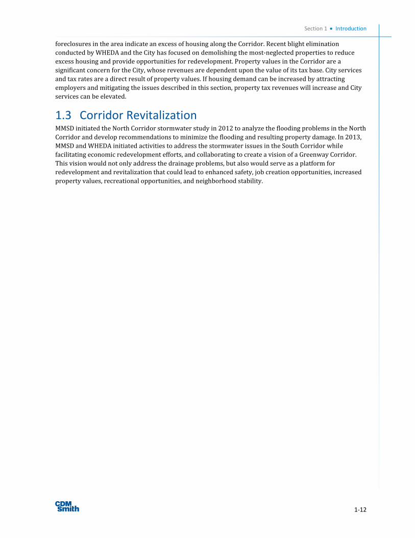
Environmental
Milwaukee has a long history of industrial
activity at a time when environmental
regulations were far less stringent than they are
today. There are considerable residential
brownfields due to the use of toxic materials
such as lead paint. In the City, there are 7,770
acres of brownfields. In the Corridor area alone,
there are 771 acres of brownfields as illustrated
in Figure 1-12.
The American Lung Association gives Milwaukee
County a grade of F, which is based on the
number of days when air quality is unhealthy for
people in sensitive groups—especially children,
the elderly, and those with respiratory issues.
Milwaukee County had 10 such days in 2011, the
most recent year where data was available
(Bergquist, 2013).
The City and Milwaukee County have made great
improvements to water quality of its waterways. MMSD has reduced the number of sewage releases in the
past two decades from roughly 50-60 per year to two to three per year (MMSD, 2012). The main challenge
for water quality in the Milwaukee area is polluted stormwater runoff. As stormwater sheet-flows over
impervious surfaces, it picks up oil, heavy metals, sediment, and other pollutants, which are ultimately
deposited into Lake Michigan. The proposed
Greenway Corridor will provide opportunities to
convert the existing brownfields into future
redevelopment and will produce improvements
in stormwater quality for the area.
Low Property Values
Extremely low assessed property values as
illustrated in Figure 1-13 represent the current
problem along the Corridor. While low property
values make it easier for people to afford a home,
it is symptomatic of the many other serious
problems discussed in this section of the City,
such as high crime, flooding risks, low
employment options, and brownfield sites.
The majority of the housing in the Corridor area
was constructed between 1880 and 1920 to
support the workers employed in the nearby
industrial and manufacturing centers. As
employment has declined in the area, so has the
demand for housing. High vacancies and
Figure 1-12. Brownfields within Corridor Area (Source: UW Extension and WHEDA)
Figure 1-13. Property Values near Corridor Area (Source: UW Extension and WHEDA)
Section 1 Introduction
1-12
foreclosures in the area indicate an excess of housing along the Corridor. Recent blight elimination
conducted by WHEDA and the City has focused on demolishing the most-neglected properties to reduce
excess housing and provide opportunities for redevelopment. Property values in the Corridor are a
significant concern for the City, whose revenues are dependent upon the value of its tax base. City services
and tax rates are a direct result of property values. If housing demand can be increased by attracting
employers and mitigating the issues described in this section, property tax revenues will increase and City
services can be elevated.
1.3 Corridor Revitalization MMSD initiated the North Corridor stormwater study in 2012 to analyze the flooding problems in the North
Corridor and develop recommendations to minimize the flooding and resulting property damage. In 2013,
MMSD and WHEDA initiated activities to address the stormwater issues in the South Corridor while
facilitating economic redevelopment efforts, and collaborating to create a vision of a Greenway Corridor.
This vision would not only address the drainage problems, but also would serve as a platform for
redevelopment and revitalization that could lead to enhanced safety, job creation opportunities, increased
property values, recreational opportunities, and neighborhood stability.

2-1
Section 2 Greenway Concepts and Opportunities
2.1 Vision The Corridor area developed in a rather short time span in the late 19th and early 20th centuries. As
neighborhoods grew adjacent to the employment opportunities provided by the Corridor, these
neighborhoods expanded to provide the necessary housing and meet employment needs with little
attention to open space and park needs. At the time, this part of the City was not able to benefit from the
evolving park planning efforts of Charles Whitnall, Secretary of the Milwaukee County Parks Commission
from 1907-1941, who successfully advocated for acquiring lands along Milwaukee County’s lakefront and
waterways for public parks. The Corridor area neighborhoods had no such waterways and, to this day, lack
green space for recreation and connection to the County’s network of greenway spaces.
The notion that this green space deficiency could in
part be addressed by a new greenway infrastructure
solution to the area’s heavy flooding damages was put
forward by MMSD and WHEDA in a collaborative
effort to address the major challenges facing the
Corridor. Their vision defined a stormwater surface
drainage way, with the introduction of adjacent
vegetation to “green” the new infrastructure and the
adjacent community. The Greenway Corridor Vision
integrates drainage and other greenway opportunities
to address stormwater and basement backup
problems, while at the same time improving the
quality of life in the Corridor neighborhoods. Figure 2-1 presents a vision of the Corridor where urban
decay and underutilized properties are replaced with a Greenway Corridor that serves as a backbone for
needed drainage improvements and is complemented by other greenway elements that provide
opportunities for open space, recreation, and urban agriculture, which all contribute to an improved quality
of life for the area.
2.2 Corridor Concept Greenways have been defined in many ways and can be
found serving the needs of people in many cultures
worldwide. They offer a common thread of improving
the quality of life for users, in part by providing
recreation opportunities linked to raising awareness of
the natural and cultural environment. Greenways occur
in widely divergent settlement patterns and successful
models can be found in urban, suburban, and rural
areas. In their most idealized form, greenways provide
contiguous non-motorized, soft-traffic connections
between the city and the country, thereby creating a
network of linked landscapes.
Figure 2-1. Greenway Corridor Vision
Figure 2-2. Example Greenway (East London Greenway)
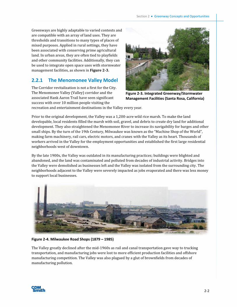
Section 2 Greenway Concepts and Opportunities
2-2
Greenways are highly adaptable to varied contexts and
are compatible with an array of land uses. They are
thresholds and transitions to many types of places of
mixed purposes. Applied in rural settings, they have
been associated with conserving prime agricultural
land. In urban areas, they are often tied to playfields
and other community facilities. Additionally, they can
be used to integrate open space uses with stormwater
management facilities, as shown in Figure 2-3.
2.2.1 The Menomonee Valley Model
The Corridor revitalization is not a first for the City.
The Menomonee Valley (Valley) corridor and the
associated Hank Aaron Trail have seen significant
success with over 10 million people visiting the
recreation and entertainment destinations in the Valley every year.
Prior to the original development, the Valley was a 1,200-acre wild rice marsh. To make the land
developable, local residents filled the marsh with soil, gravel, and debris to create dry land for additional
development. They also straightened the Menomonee River to increase its navigability for barges and other
small ships. By the turn of the 19th Century, Milwaukee was known as the “Machine Shop of the World”,
making farm machinery, rail cars, electric motors, and cranes with the Valley as its heart. Thousands of
workers arrived in the Valley for the employment opportunities and established the first large residential
neighborhoods west of downtown.
By the late 1900s, the Valley was outdated in its manufacturing practices; buildings were blighted and
abandoned, and the land was contaminated and polluted from decades of industrial activity. Bridges into
the Valley were demolished as businesses left and the Valley was isolated from the surrounding city. The
neighborhoods adjacent to the Valley were severely impacted as jobs evaporated and there was less money
to support local businesses.
Figure 2-4. Milwaukee Road Shops (1879 – 1985)
The Valley greatly declined after the mid-1960s as rail and canal transportation gave way to trucking
transportation, and manufacturing jobs were lost to more efficient production facilities and offshore
manufacturing competition. The Valley was also plagued by a glut of brownfields from decades of
manufacturing pollution.
Figure 2-3. Integrated Greenway/Stormwater Management Facilities (Santa Rosa, California)
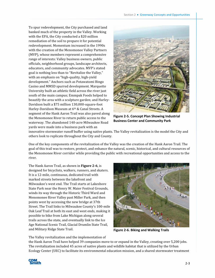
Section 2 Greenway Concepts and Opportunities
2-3
To spur redevelopment, the City purchased and land
banked much of the property in the Valley. Working
with the EPA, the City conducted a $20 million
remediation of the soil to prepare it for potential
redevelopment. Momentum increased in the 1990s
with the creation of the Menomonee Valley Partners
(MVP), whose members represent a comprehensive
range of interests: Valley business owners, public
officials, neighborhood groups, landscape architects,
educators, and community advocates. MVP’s stated
goal is nothing less than to “Revitalize the Valley,”
with an emphasis on “high-quality, high-yield
development.” Anchors such as Potawatomi Bingo
Casino and MMSD spurred development. Marquette
University built an athletic field across the river just
south of the main campus; Emmpak Foods helped to
beautify the area with a sculpture garden; and Harley-
Davidson built a $75 million 130,000-square-foot
Harley-Davidson Museum at 6th & Canal Streets. A
segment of the Hank Aaron Trail was also paved along
the Menomonee River to return public access to the
waterway. The abandoned 140-acre Milwaukee Road
yards were made into a business park with an
innovative stormwater runoff buffer using native plants. The Valley revitalization is the model the City and
others look to replicate throughout the City and County.
One of the key components of the revitalization of the Valley was the creation of the Hank Aaron Trail. The
goal of this trail was to restore, protect, and enhance the natural, scenic, historical, and cultural resources of
the Menomonee River corridor while providing the public with recreational opportunities and access to the
river.
The Hank Aaron Trail, as shown in Figure 2-6, is
designed for bicyclists, walkers, runners, and skaters.
It is a 12-mile, continuous, dedicated trail with
marked streets between the lakefront and
Milwaukee's west end. The Trail starts at Lakeshore
State Park near the Henry W. Maier Festival Grounds,
winds its way through the Historic Third Ward and
Menomonee River Valley past Miller Park, and then
points west by accessing the new bridge at 37th
Street. The Trail links to Milwaukee County's 100-mile
Oak Leaf Trail at both its east and west ends, making it
possible to bike from Lake Michigan along several
trails across the state, and eventually link to the Ice
Age National Scenic Trail, Glacial Drumlin State Trail,
and Military Ridge State Trail.
The Valley revitalization and the implementation of
the Hank Aaron Trail have helped 39 companies move to or expand in the Valley, creating over 5,200 jobs.
The revitalization included 45 acres of native plants and wildlife habitat that is utilized by the Urban
Ecology Center (UEC) to facilitate its environmental education mission, and a shared stormwater treatment
Figure 2-5. Concept Plan Showing Industrial Business Center and Community Park
Figure 2-6. Biking and Walking Trails
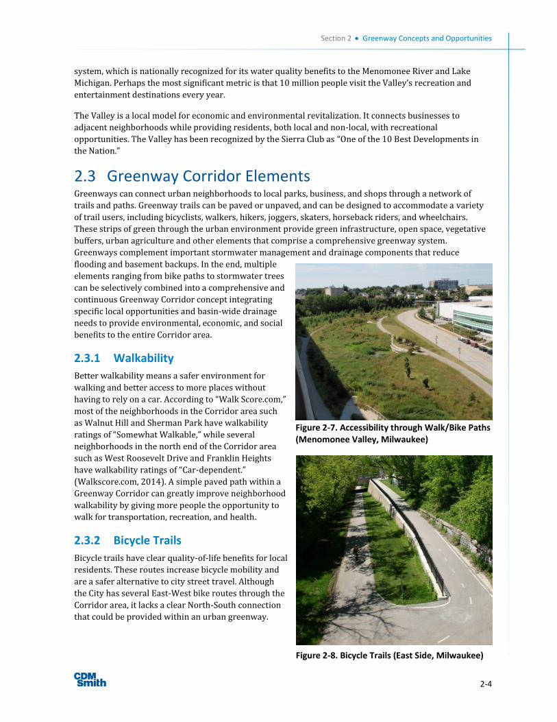
Section 2 Greenway Concepts and Opportunities
2-4
system, which is nationally recognized for its water quality benefits to the Menomonee River and Lake
Michigan. Perhaps the most significant metric is that 10 million people visit the Valley’s recreation and
entertainment destinations every year.
The Valley is a local model for economic and environmental revitalization. It connects businesses to
adjacent neighborhoods while providing residents, both local and non-local, with recreational
opportunities. The Valley has been recognized by the Sierra Club as “One of the 10 Best Developments in
the Nation.”
2.3 Greenway Corridor Elements Greenways can connect urban neighborhoods to local parks, business, and shops through a network of
trails and paths. Greenway trails can be paved or unpaved, and can be designed to accommodate a variety
of trail users, including bicyclists, walkers, hikers, joggers, skaters, horseback riders, and wheelchairs.
These strips of green through the urban environment provide green infrastructure, open space, vegetative
buffers, urban agriculture and other elements that comprise a comprehensive greenway system.
Greenways complement important stormwater management and drainage components that reduce
flooding and basement backups. In the end, multiple
elements ranging from bike paths to stormwater trees
can be selectively combined into a comprehensive and
continuous Greenway Corridor concept integrating
specific local opportunities and basin-wide drainage
needs to provide environmental, economic, and social
benefits to the entire Corridor area.
2.3.1 Walkability
Better walkability means a safer environment for
walking and better access to more places without
having to rely on a car. According to “Walk Score.com,”
most of the neighborhoods in the Corridor area such
as Walnut Hill and Sherman Park have walkability
ratings of “Somewhat Walkable,” while several
neighborhoods in the north end of the Corridor area
such as West Roosevelt Drive and Franklin Heights
have walkability ratings of “Car-dependent.”
(Walkscore.com, 2014). A simple paved path within a
Greenway Corridor can greatly improve neighborhood
walkability by giving more people the opportunity to
walk for transportation, recreation, and health.
2.3.2 Bicycle Trails
Bicycle trails have clear quality-of-life benefits for local
residents. These routes increase bicycle mobility and
are a safer alternative to city street travel. Although
the City has several East-West bike routes through the
Corridor area, it lacks a clear North-South connection
that could be provided within an urban greenway.
Figure 2-8. Bicycle Trails (East Side, Milwaukee)
Figure 2-7. Accessibility through Walk/Bike Paths (Menomonee Valley, Milwaukee)
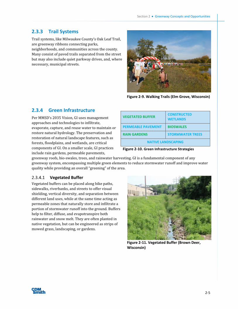
Section 2 Greenway Concepts and Opportunities
2-5
2.3.3 Trail Systems
Trail systems, like Milwaukee County’s Oak Leaf Trail,
are greenway ribbons connecting parks,
neighborhoods, and communities across the county.
Many consist of paved trails separated from the street
but may also include quiet parkway drives, and, where
necessary, municipal streets.
2.3.4 Green Infrastructure
Per MMSD’s 2035 Vision, GI uses management
approaches and technologies to infiltrate,
evaporate, capture, and reuse water to maintain or
restore natural hydrology. The preservation and
restoration of natural landscape features, such as
forests, floodplains, and wetlands, are critical
components of GI. On a smaller scale, GI practices
include rain gardens, permeable pavements,
greenway roofs, bio-swales, trees, and rainwater harvesting. GI is a fundamental component of any
greenway system, encompassing multiple green elements to reduce stormwater runoff and improve water
quality while providing an overall “greening” of the area.
Vegetated Buffer
Vegetated buffers can be placed along bike paths,
sidewalks, riverbanks, and streets to offer visual
shielding, vertical diversity, and separation between
different land uses, while at the same time acting as
permeable zones that naturally store and infiltrate a
portion of stormwater runoff into the ground. Buffers
help to filter, diffuse, and evapotranspire both
rainwater and snow melt. They are often planted in
native vegetation, but can be engineered as strips of
mowed grass, landscaping, or gardens.
VEGETATED BUFFER CONSTRUCTED WETLANDS
PERMEABLE PAVEMENT BIOSWALES
RAIN GARDENS STORMWATER TREES
NATIVE LANDSCAPING
Figure 2-10. Green Infrastructure Strategies
Figure 2-11. Vegetated Buffer (Brown Deer, Wisconsin)
Figure 2-9. Walking Trails (Elm Grove, Wisconsin)
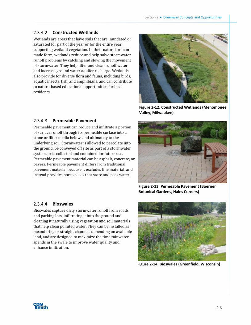
Section 2 Greenway Concepts and Opportunities
2-6
Constructed Wetlands
Wetlands are areas that have soils that are inundated or
saturated for part of the year or for the entire year,
supporting wetland vegetation. In their natural or man-
made form, wetlands reduce and help solve stormwater
runoff problems by catching and slowing the movement
of stormwater. They help filter and clean runoff water
and increase ground water aquifer recharge. Wetlands
also provide for diverse flora and fauna, including birds,
aquatic insects, fish, and amphibians, and can contribute
to nature-based educational opportunities for local
residents.
Permeable Pavement
Permeable pavement can reduce and infiltrate a portion
of surface runoff through its permeable surface into a
stone or filter media below, and ultimately to the
underlying soil. Stormwater is allowed to percolate into
the ground, be conveyed off site as part of a stormwater
system, or is collected and contained for future use.
Permeable pavement material can be asphalt, concrete, or
pavers. Permeable pavement differs from traditional
pavement material because it excludes fine material, and
instead provides pore spaces that store and pass water.
Bioswales
Bioswales capture dirty stormwater runoff from roads
and parking lots, infiltrating it into the ground and
cleaning it naturally using vegetation and soil materials
that help clean polluted water. They can be installed as
meandering or straight channels depending on available
land, and are designed to maximize the time rainwater
spends in the swale to improve water quality and
enhance infiltration.
Figure 2-13. Permeable Pavement (Boerner Botanical Gardens, Hales Corners)
Figure 2-14. Bioswales (Greenfield, Wisconsin)
Figure 2-12. Constructed Wetlands (Menomonee Valley, Milwaukee)
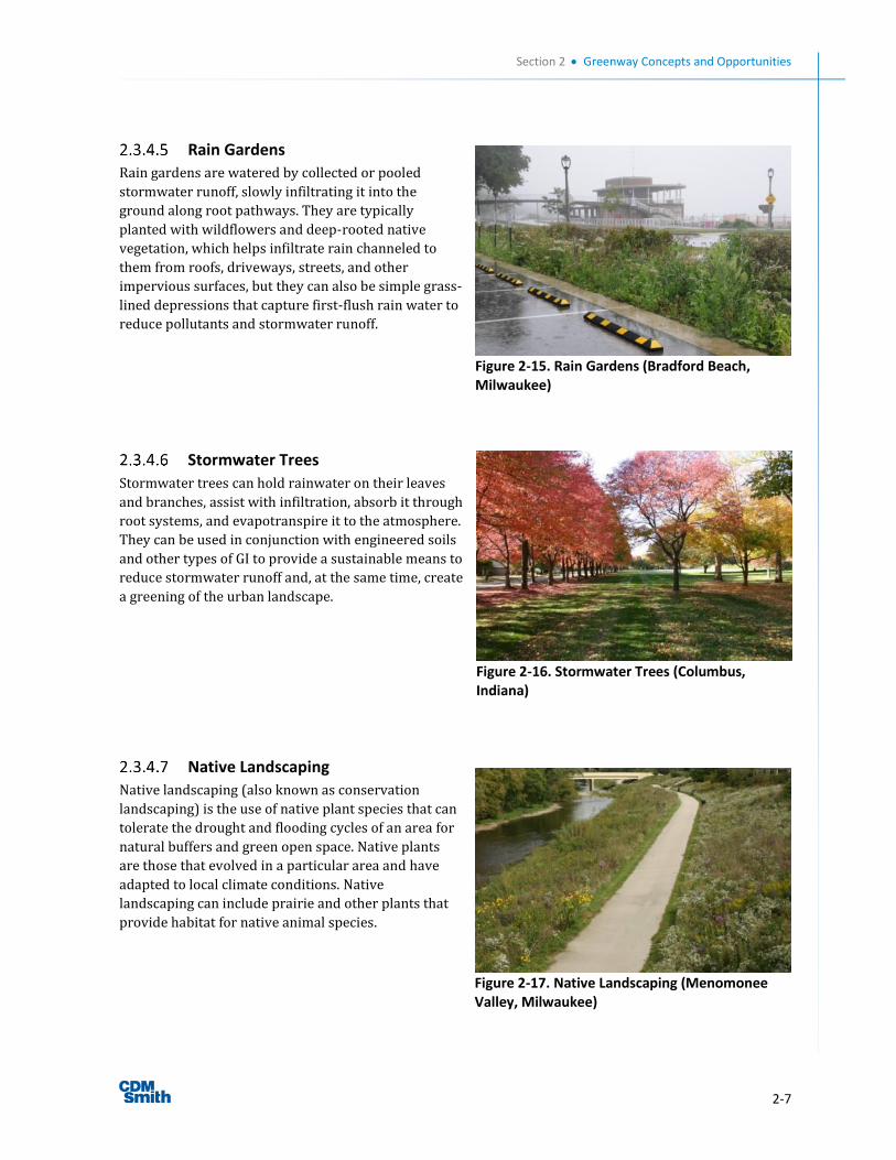
Section 2 Greenway Concepts and Opportunities
2-7
Rain Gardens
Rain gardens are watered by collected or pooled
stormwater runoff, slowly infiltrating it into the
ground along root pathways. They are typically
planted with wildflowers and deep-rooted native
vegetation, which helps infiltrate rain channeled to
them from roofs, driveways, streets, and other
impervious surfaces, but they can also be simple grass-
lined depressions that capture first-flush rain water to
reduce pollutants and stormwater runoff.
Stormwater Trees
Stormwater trees can hold rainwater on their leaves
and branches, assist with infiltration, absorb it through
root systems, and evapotranspire it to the atmosphere.
They can be used in conjunction with engineered soils
and other types of GI to provide a sustainable means to
reduce stormwater runoff and, at the same time, create
a greening of the urban landscape.
Native Landscaping
Native landscaping (also known as conservation
landscaping) is the use of native plant species that can
tolerate the drought and flooding cycles of an area for
natural buffers and green open space. Native plants
are those that evolved in a particular area and have
adapted to local climate conditions. Native
landscaping can include prairie and other plants that
provide habitat for native animal species.
Figure 2-15. Rain Gardens (Bradford Beach, Milwaukee)
Figure 2-16. Stormwater Trees (Columbus, Indiana)
Figure 2-17. Native Landscaping (Menomonee Valley, Milwaukee)
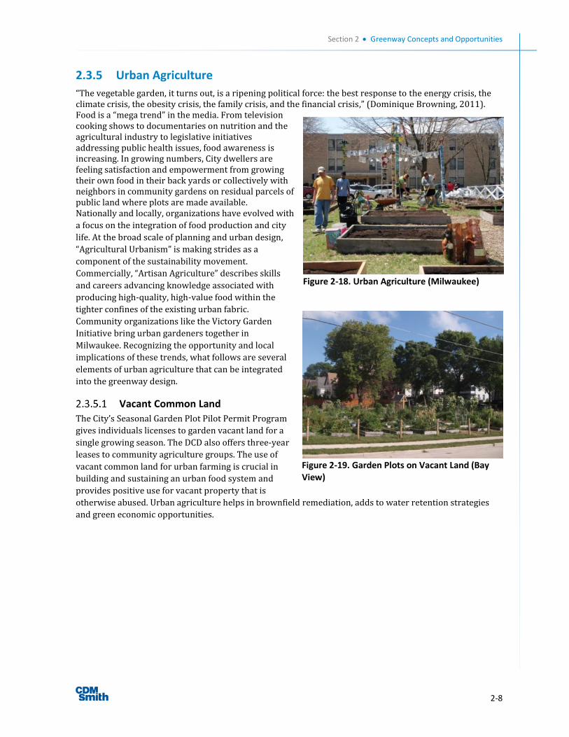
Section 2 Greenway Concepts and Opportunities
2-8
2.3.5 Urban Agriculture
“The vegetable garden, it turns out, is a ripening political force: the best response to the energy crisis, the climate crisis, the obesity crisis, the family crisis, and the financial crisis,” (Dominique Browning, 2011). Food is a “mega trend” in the media. From television cooking shows to documentaries on nutrition and the agricultural industry to legislative initiatives addressing public health issues, food awareness is increasing. In growing numbers, City dwellers are feeling satisfaction and empowerment from growing their own food in their back yards or collectively with neighbors in community gardens on residual parcels of public land where plots are made available. Nationally and locally, organizations have evolved with
a focus on the integration of food production and city
life. At the broad scale of planning and urban design,
“Agricultural Urbanism” is making strides as a
component of the sustainability movement.
Commercially, “Artisan Agriculture” describes skills
and careers advancing knowledge associated with
producing high-quality, high-value food within the
tighter confines of the existing urban fabric.
Community organizations like the Victory Garden
Initiative bring urban gardeners together in
Milwaukee. Recognizing the opportunity and local
implications of these trends, what follows are several
elements of urban agriculture that can be integrated
into the greenway design.
Vacant Common Land
The City’s Seasonal Garden Plot Pilot Permit Program
gives individuals licenses to garden vacant land for a
single growing season. The DCD also offers three-year
leases to community agriculture groups. The use of
vacant common land for urban farming is crucial in
building and sustaining an urban food system and
provides positive use for vacant property that is
otherwise abused. Urban agriculture helps in brownfield remediation, adds to water retention strategies
and green economic opportunities.
Figure 2-19. Garden Plots on Vacant Land (Bay View)
Figure 2-18. Urban Agriculture (Milwaukee)
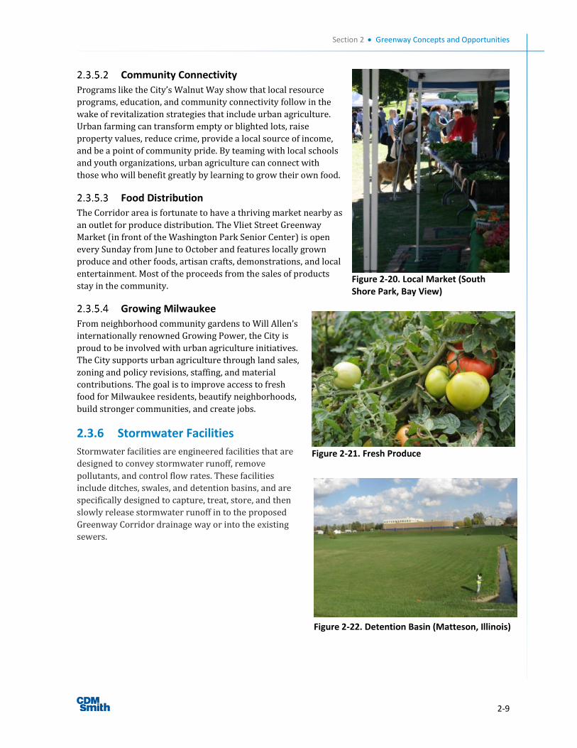
Section 2 Greenway Concepts and Opportunities
2-9
Community Connectivity
Programs like the City’s Walnut Way show that local resource
programs, education, and community connectivity follow in the
wake of revitalization strategies that include urban agriculture.
Urban farming can transform empty or blighted lots, raise
property values, reduce crime, provide a local source of income,
and be a point of community pride. By teaming with local schools
and youth organizations, urban agriculture can connect with
those who will benefit greatly by learning to grow their own food.
Food Distribution
The Corridor area is fortunate to have a thriving market nearby as
an outlet for produce distribution. The Vliet Street Greenway
Market (in front of the Washington Park Senior Center) is open
every Sunday from June to October and features locally grown
produce and other foods, artisan crafts, demonstrations, and local
entertainment. Most of the proceeds from the sales of products
stay in the community.
Growing Milwaukee
From neighborhood community gardens to Will Allen’s
internationally renowned Growing Power, the City is
proud to be involved with urban agriculture initiatives.
The City supports urban agriculture through land sales,
zoning and policy revisions, staffing, and material
contributions. The goal is to improve access to fresh
food for Milwaukee residents, beautify neighborhoods,
build stronger communities, and create jobs.
2.3.6 Stormwater Facilities
Stormwater facilities are engineered facilities that are
designed to convey stormwater runoff, remove
pollutants, and control flow rates. These facilities
include ditches, swales, and detention basins, and are
specifically designed to capture, treat, store, and then
slowly release stormwater runoff in to the proposed
Greenway Corridor drainage way or into the existing
sewers.
Figure 2-20. Local Market (South Shore Park, Bay View)
Figure 2-21. Fresh Produce
Figure 2-22. Detention Basin (Matteson, Illinois)
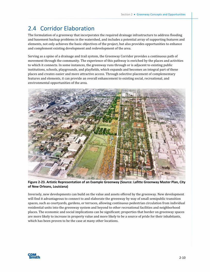
Section 2 Greenway Concepts and Opportunities
2-10
2.4 Corridor Elaboration The formulation of a greenway that incorporates the required drainage infrastructure to address flooding
and basement backup problems in the watershed, and includes a potential array of supporting features and
elements, not only achieves the basic objectives of the project, but also provides opportunities to enhance
and complement existing development and redevelopment of the area.
Serving as a spine of a drainage and trail system, the Greenway Corridor provides a continuous path of
movement through the community. The experience of this pathway is enriched by the places and activities
to which it connects. In some instances, the greenway runs through or is adjacent to existing public
institutions, schools, playgrounds, and playfields, which expands and becomes an integral part of these
places and creates easier and more attractive access. Through selective placement of complementary
features and elements, it can provide an overall enhancement to existing social, recreational, and
environmental opportunities of the area.
Figure 2-23. Artistic Representation of an Example Greenway (Source: Lafitte Greenway Master Plan, City of New Orleans, Louisiana)
Inversely, new developments can build on the value and assets offered by the greenway. New development
will find it advantageous to connect to and elaborate the greenway by way of small semipublic transition
spaces, such as courtyards, gardens, or terraces, allowing continuous pedestrian circulation from individual
residential units into the greenway system and beyond to other recreational facilities and neighborhood
places. The economic and social implications can be significant; properties that border on greenway spaces
are more likely to increase in property value and more likely to be a source of pride for their inhabitants,
which has been proven to be the case at many other locations.
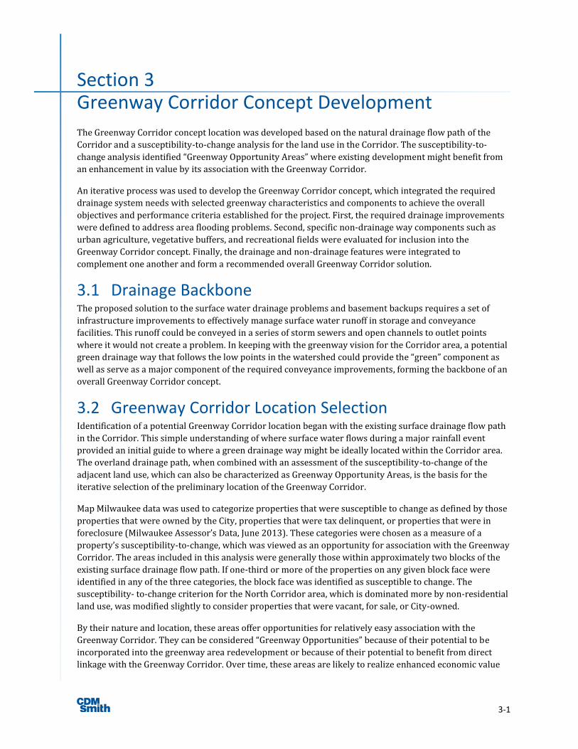
3-1
Section 3 Greenway Corridor Concept Development
The Greenway Corridor concept location was developed based on the natural drainage flow path of the
Corridor and a susceptibility-to-change analysis for the land use in the Corridor. The susceptibility-to-
change analysis identified “Greenway Opportunity Areas” where existing development might benefit from
an enhancement in value by its association with the Greenway Corridor.
An iterative process was used to develop the Greenway Corridor concept, which integrated the required
drainage system needs with selected greenway characteristics and components to achieve the overall
objectives and performance criteria established for the project. First, the required drainage improvements
were defined to address area flooding problems. Second, specific non-drainage way components such as
urban agriculture, vegetative buffers, and recreational fields were evaluated for inclusion into the
Greenway Corridor concept. Finally, the drainage and non-drainage features were integrated to
complement one another and form a recommended overall Greenway Corridor solution.
3.1 Drainage Backbone The proposed solution to the surface water drainage problems and basement backups requires a set of
infrastructure improvements to effectively manage surface water runoff in storage and conveyance
facilities. This runoff could be conveyed in a series of storm sewers and open channels to outlet points
where it would not create a problem. In keeping with the greenway vision for the Corridor area, a potential
green drainage way that follows the low points in the watershed could provide the “green” component as
well as serve as a major component of the required conveyance improvements, forming the backbone of an
overall Greenway Corridor concept.
3.2 Greenway Corridor Location Selection Identification of a potential Greenway Corridor location began with the existing surface drainage flow path
in the Corridor. This simple understanding of where surface water flows during a major rainfall event
provided an initial guide to where a green drainage way might be ideally located within the Corridor area.
The overland drainage path, when combined with an assessment of the susceptibility-to-change of the
adjacent land use, which can also be characterized as Greenway Opportunity Areas, is the basis for the
iterative selection of the preliminary location of the Greenway Corridor.
Map Milwaukee data was used to categorize properties that were susceptible to change as defined by those
properties that were owned by the City, properties that were tax delinquent, or properties that were in
foreclosure (Milwaukee Assessor’s Data, June 2013). These categories were chosen as a measure of a
property’s susceptibility-to-change, which was viewed as an opportunity for association with the Greenway
Corridor. The areas included in this analysis were generally those within approximately two blocks of the
existing surface drainage flow path. If one-third or more of the properties on any given block face were
identified in any of the three categories, the block face was identified as susceptible to change. The
susceptibility- to-change criterion for the North Corridor area, which is dominated more by non-residential
land use, was modified slightly to consider properties that were vacant, for sale, or City-owned.
By their nature and location, these areas offer opportunities for relatively easy association with the
Greenway Corridor. They can be considered “Greenway Opportunities” because of their potential to be
incorporated into the greenway area redevelopment or because of their potential to benefit from direct
linkage with the Greenway Corridor. Over time, these areas are likely to realize enhanced economic value
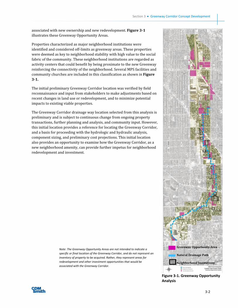
Section 3 Greenway Corridor Concept Development
3-2
associated with new ownership and new redevelopment. Figure 3-1
illustrates these Greenway Opportunity Areas.
Properties characterized as major neighborhood institutions were
identified and considered off-limits as greenway areas. These properties
were deemed as key to neighborhood stability with high value to the social
fabric of the community. These neighborhood institutions are regarded as
activity centers that could benefit by being proximate to the new Greenway
reinforcing the connectivity of the neighborhood. Several MPS facilities and
community churches are included in this classification as shown in Figure
3-1.
The initial preliminary Greenway Corridor location was verified by field
reconnaissance and input from stakeholders to make adjustments based on
recent changes in land use or redevelopment, and to minimize potential
impacts to existing viable properties.
The Greenway Corridor drainage way location selected from this analysis is
preliminary and is subject to continuous change from ongoing property
transactions, further planning and analysis, and community input. However,
this initial location provides a reference for locating the Greenway Corridor,
and a basis for proceeding with the hydrologic and hydraulic analysis,
component sizing, and preliminary cost projections. This initial location
also provides an opportunity to examine how the Greenway Corridor, as a
new neighborhood amenity, can provide further impetus for neighborhood
redevelopment and investment.
Figure 3-1. Greenway Opportunity Analysis
Greenway Opportunity Area
Natural Drainage Path
Neighborhood Institutions
Note: The Greenway Opportunity Areas are not intended to indicate a
specific or final location of the Greenway Corridor, and do not represent an
inventory of property to be acquired. Rather, they represent areas for
redevelopment and other investment opportunities that would be
associated with the Greenway Corridor.
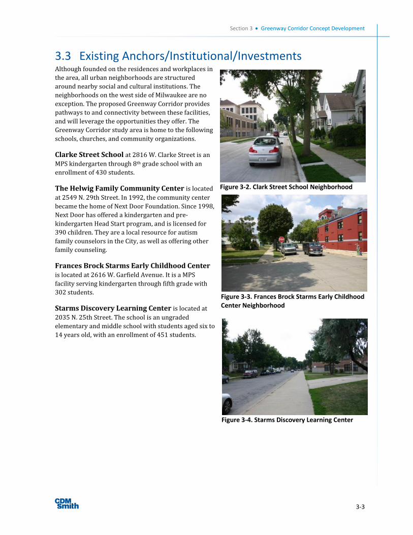
Section 3 Greenway Corridor Concept Development
3-3
3.3 Existing Anchors/Institutional/Investments Although founded on the residences and workplaces in
the area, all urban neighborhoods are structured
around nearby social and cultural institutions. The
neighborhoods on the west side of Milwaukee are no
exception. The proposed Greenway Corridor provides
pathways to and connectivity between these facilities,
and will leverage the opportunities they offer. The
Greenway Corridor study area is home to the following
schools, churches, and community organizations.
Clarke Street School at 2816 W. Clarke Street is an
MPS kindergarten through 8th grade school with an
enrollment of 430 students.
The Helwig Family Community Center is located
at 2549 N. 29th Street. In 1992, the community center
became the home of Next Door Foundation. Since 1998,
Next Door has offered a kindergarten and pre-
kindergarten Head Start program, and is licensed for
390 children. They are a local resource for autism
family counselors in the City, as well as offering other
family counseling.
Frances Brock Starms Early Childhood Center is located at 2616 W. Garfield Avenue. It is a MPS
facility serving kindergarten through fifth grade with
302 students.
Starms Discovery Learning Center is located at
2035 N. 25th Street. The school is an ungraded
elementary and middle school with students aged six to
14 years old, with an enrollment of 451 students.
Figure 3-2. Clark Street School Neighborhood
Figure 3-3. Frances Brock Starms Early Childhood Center Neighborhood
Figure 3-4. Starms Discovery Learning Center
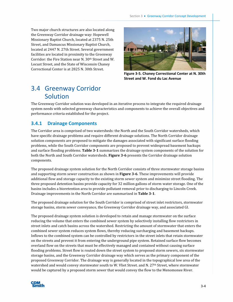
Section 3 Greenway Corridor Concept Development
3-4
Two major church structures are also located along
the Greenway Corridor drainage way: Hopewell
Missionary Baptist Church, located at 2375 N. 25th
Street, and Damascus Missionary Baptist Church,
located at 2447 N. 27th Street. Several government
facilities are located in proximity to the Greenway
Corridor: the Fire Station near N. 30th Street and W.
Locust Street, and the State of Wisconsin Chaney
Correctional Center is at 2825 N. 30th Street.
3.4 Greenway Corridor Solution
The Greenway Corridor solution was developed in an iterative process to integrate the required drainage
system needs with selected greenway characteristics and components to achieve the overall objectives and
performance criteria established for the project.
3.4.1 Drainage Components
The Corridor area is comprised of two watersheds: the North and the South Corridor watersheds, which
have specific drainage problems and require different drainage solutions. The North Corridor drainage
solution components are proposed to mitigate the damages associated with significant surface flooding
problems, while the South Corridor components are proposed to prevent widespread basement backups
and surface flooding problems. Table 3-1 summarizes the drainage system components of the solution for
both the North and South Corridor watersheds. Figure 3-6 presents the Corridor drainage solution
components.
The proposed drainage system solution for the North Corridor consists of three stormwater storage basins
and supporting storm sewer construction as shown in Figure 3-6. These improvements will provide
additional flow and storage capacity to the existing storm sewer system and minimize street flooding. The
three proposed detention basins provide capacity for 32 million gallons of storm water storage. One of the
basins includes a bioretention area to provide pollutant removal prior to discharging to Lincoln Creek.
Drainage improvements in the North Corridor are summarized in Table 3-1.
The proposed drainage solution for the South Corridor is comprised of street inlet restrictors, stormwater
storage basins, storm sewer conveyance, the Greenway Corridor drainage way, and associated GI.
The proposed drainage system solution is developed to retain and manage stormwater on the surface
reducing the volume that enters the combined sewer system by selectively installing flow restrictors in
street inlets and catch basins across the watershed. Restricting the amount of stormwater that enters the
combined sewer system reduces system flows, thereby reducing surcharging and basement backups.
Inflows to the combined system can be controlled by restrictors in the street inlets that retain stormwater
on the streets and prevent it from entering the underground pipe system. Retained surface flow becomes
overland flow on the streets that must be effectively managed and contained without causing surface
flooding problems. Street flow is routed down the street system to proposed storm sewers, six stormwater
storage basins, and the Greenway Corridor drainage way which serves as the primary component of the
proposed Greenway Corridor. The drainage way is generally located in the topographical low area of the
watershed and would convey stormwater south to W. Vliet Street. and N. 27th Street, where stormwater
would be captured by a proposed storm sewer that would convey the flow to the Menomonee River.
Figure 3-5. Chaney Correctional Center at N. 30th Street and W. Fond du Lac Avenue
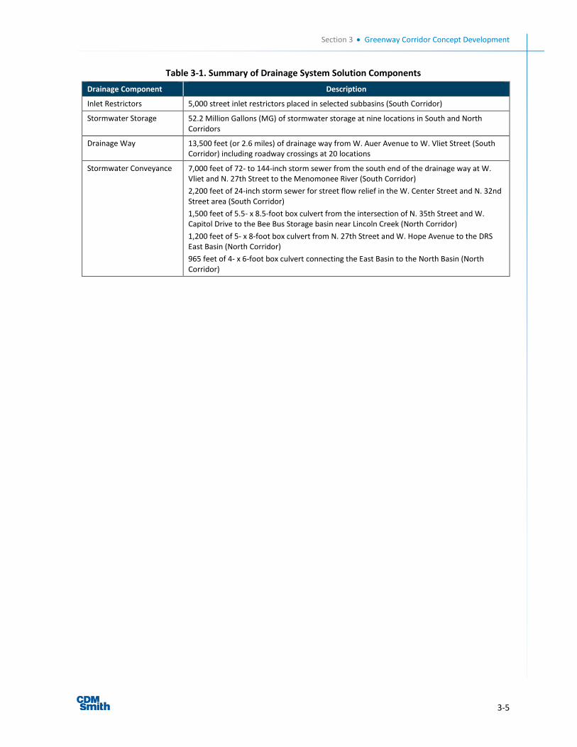
Section 3 Greenway Corridor Concept Development
3-5
Table 3-1. Summary of Drainage System Solution Components
Drainage Component Description
Inlet Restrictors 5,000 street inlet restrictors placed in selected subbasins (South Corridor)
Stormwater Storage 52.2 Million Gallons (MG) of stormwater storage at nine locations in South and North Corridors
Drainage Way 13,500 feet (or 2.6 miles) of drainage way from W. Auer Avenue to W. Vliet Street (South Corridor) including roadway crossings at 20 locations
Stormwater Conveyance 7,000 feet of 72- to 144-inch storm sewer from the south end of the drainage way at W. Vliet and N. 27th Street to the Menomonee River (South Corridor)
2,200 feet of 24-inch storm sewer for street flow relief in the W. Center Street and N. 32nd Street area (South Corridor)
1,500 feet of 5.5- x 8.5-foot box culvert from the intersection of N. 35th Street and W. Capitol Drive to the Bee Bus Storage basin near Lincoln Creek (North Corridor)
1,200 feet of 5- x 8-foot box culvert from N. 27th Street and W. Hope Avenue to the DRS East Basin (North Corridor)
965 feet of 4- x 6-foot box culvert connecting the East Basin to the North Basin (North Corridor)
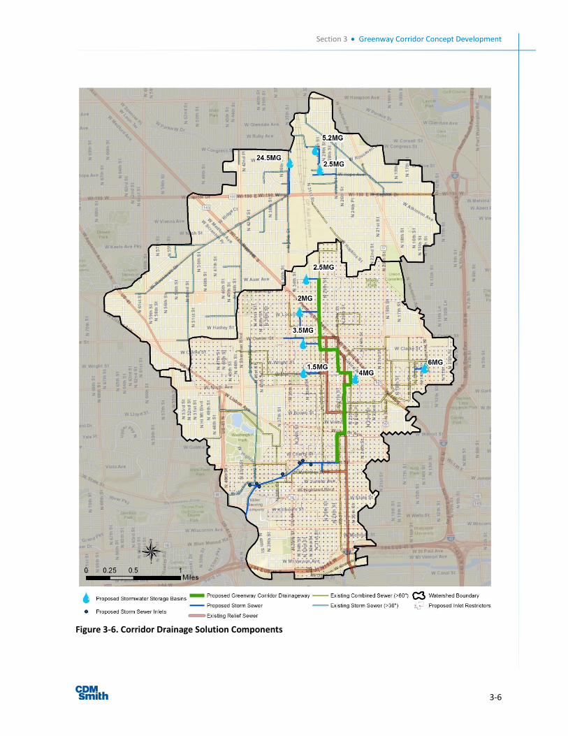
Section 3 Greenway Corridor Concept Development
3-6
Figure 3-6. Corridor Drainage Solution Components

Section 3 Greenway Corridor Concept Development
3-7
3.4.2 Greenway Components
An urban greenway provides the opportunity for many additional benefits beyond a drainage solution to
surface flooding and basement backup flooding problems. An urban greenway can also complement the
adjacent neighborhoods, provide specific elements to strengthen the local social fabric of the area, and
greatly enhance the value of that portion of the Corridor area.
Definition of the appropriate features and elements of the Greenway Corridor began with four fundamental
components:
A drainage channel
A landscaped strip of land
A continuous path or trail for recreational and transportation use
A continuous vertical identity of the Greenway Corridor marked with vegetation
Specific features and elements were added to these fundamental components based on the identified
opportunities and needs of individual blocks or segments of the Greenway Corridor.
The concept of greenways is certainly not unique; it has been used extensively in many communities in the
United States, including the renowned plan layout of Greendale, WI, and the much acclaimed
environmentally progressive redevelopment of the Menomonee Valley. The overall concept of the
Greenway Corridor is shown in Figure 3-7. The Greenway Corridor location is conceptual and generally
shown down the centerline of the street from north to south. However, the final location of the Greenway
Corridor will be on one side or another of the street based on the specific characteristics of the block,
known development opportunities, drainage requirements, and the unique needs of the adjacent
neighborhood.
As the Greenway Corridor drainage way winds its way from north to south, land uses vary along its edges.
While the drainage and trail components provide a consistent framework for the Greenway Corridor, the
landscaping in particular can provide multiple opportunities to flexibly address and adjust to local
conditions. Landscape strategies combined with stormwater BMPs for any particular block will vary and
therefore provide richness and variety that will allow the Greenway Corridor to visually transform the
adjacent neighborhood settings.
A number of elements were considered to be incorporated with the drainage way within the Greenway
Corridor. Potential elements included bike paths, vegetated buffers, GI Best Management Practices (BMP),
urban agriculture, etc. These elements, combined with drainage requirements and preferences of the
Stakeholder Group, form the preliminary Greenway Corridor concepts by segment along the Corridor.
Incorporation of these elements was considered on a reach-by-reach basis depending on the specific needs
and opportunities associated with each reach.
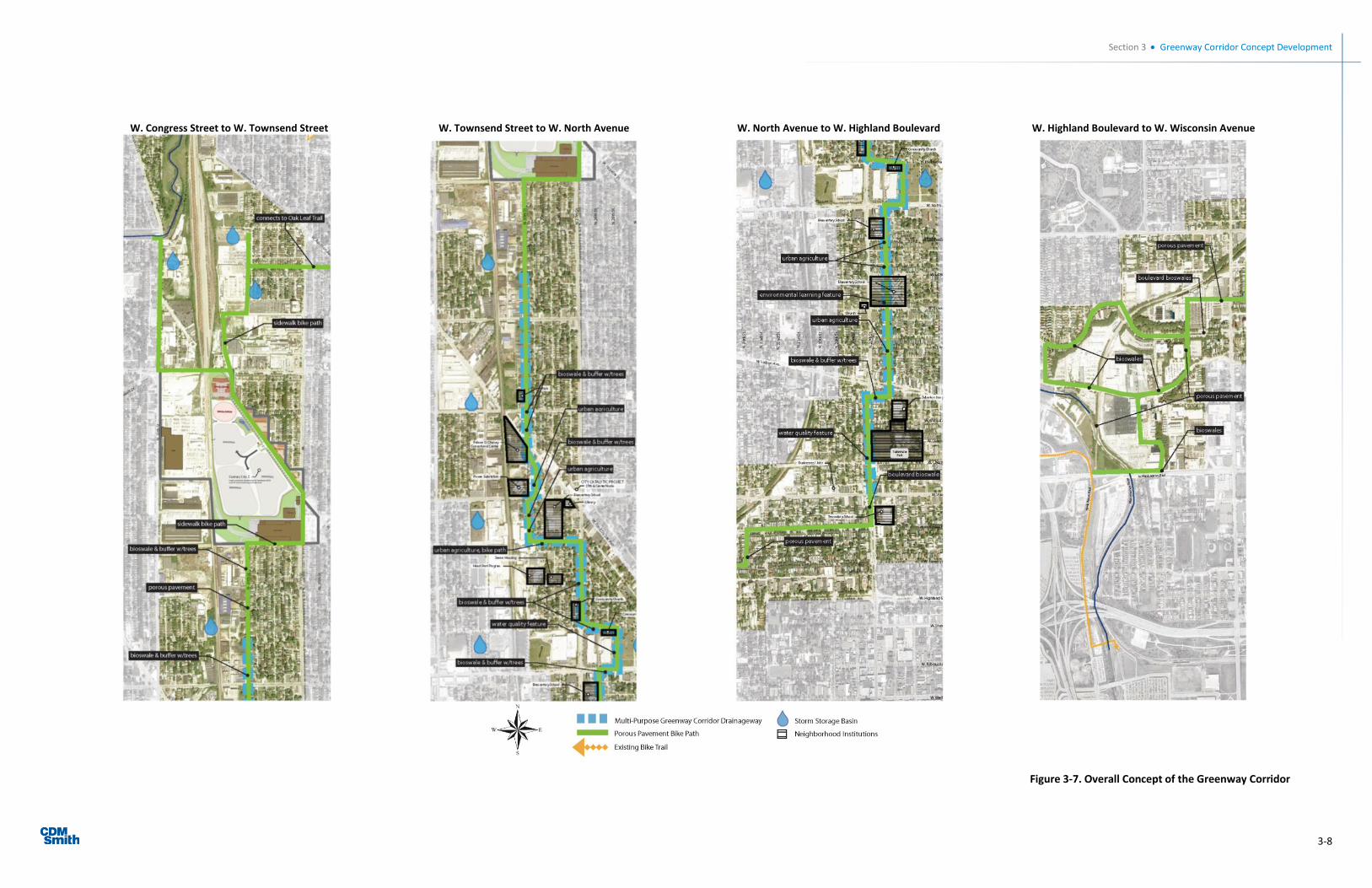
Section 3 Greenway Corridor Concept Development
3-8
W. Congress Street to W. Townsend Street W. Townsend Street to W. North Avenue W. North Avenue to W. Highland Boulevard W. Highland Boulevard to W. Wisconsin Avenue
Figure 3-7. Overall Concept of the Greenway Corridor
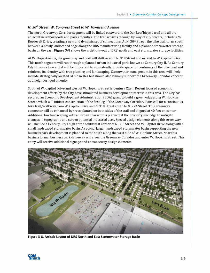
Section 3 Greenway Corridor Concept Development
3-9
N. 30th Street: W. Congress Street to W. Townsend Avenue
The north Greenway Corridor segment will be linked eastward to the Oak Leaf bicycle trail and all the
adjacent neighborhoods and park amenities. The trail weaves through by way of city streets, including W.
Roosevelt Drive, creating a new and dynamic set of connections. At N. 30th Street, the bike trail turns south
between a newly landscaped edge along the DRS manufacturing facility and a planned stormwater storage
basin on the east. Figure 3-8 shows the artistic layout of DRS’ north and east stormwater storage facilities.
At W. Hope Avenue, the greenway and trail will shift over to N. 31st Street and extend to W. Capitol Drive.
This north segment will run through a planned urban industrial park, known as Century City II. As Century
City II moves forward, it will be important to consistently provide space for continuity of the bike trail and
reinforce its identity with tree planting and landscaping. Stormwater management in this area will likely
include strategically located GI bioswales but should also visually support the Greenway Corridor concept
as a neighborhood amenity.
South of W. Capitol Drive and west of W. Hopkins Street is Century City I. Recent focused economic
development efforts by the City have stimulated business development interest in this area. The City has
secured an Economic Development Administration (EDA) grant to build a green edge along W. Hopkins
Street, which will initiate construction of the first leg of the Greenway Corridor. Plans call for a continuous
bike trail/walkway from W. Capitol Drive and N. 31st Street south to N. 27th Street. This greenway
connector will be enhanced by trees planted on both sides of the trail and aligned at 40 feet on center.
Additional low landscaping with an urban character is planned at the property line edge to mitigate
changes in topography and screen potential industrial uses. Special design elements along this greenway
will include a Century City I sign at the southwest corner of N. 31st Street and W. Capitol Drive along with a
small landscaped stormwater basin. A second, larger landscaped stormwater basin supporting the new
business park development is planned to the south along the west side of W. Hopkins Street. Near this
basin, a formal business park driveway will cross the Greenway Corridor and enter W. Hopkins Street. This
entry will receive additional signage and entranceway design elements.
Figure 3-8. Artistic Layout of DRS North and East Stormwater Storage Basin
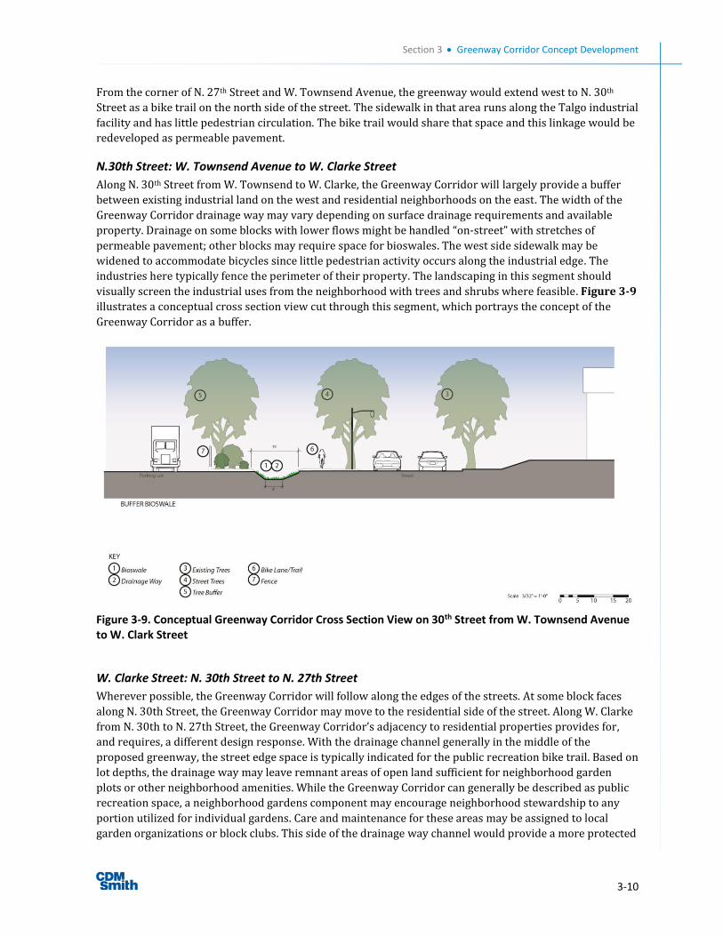
Section 3 Greenway Corridor Concept Development
3-10
From the corner of N. 27th Street and W. Townsend Avenue, the greenway would extend west to N. 30th
Street as a bike trail on the north side of the street. The sidewalk in that area runs along the Talgo industrial
facility and has little pedestrian circulation. The bike trail would share that space and this linkage would be
redeveloped as permeable pavement.
N.30th Street: W. Townsend Avenue to W. Clarke Street
Along N. 30th Street from W. Townsend to W. Clarke, the Greenway Corridor will largely provide a buffer
between existing industrial land on the west and residential neighborhoods on the east. The width of the
Greenway Corridor drainage way may vary depending on surface drainage requirements and available
property. Drainage on some blocks with lower flows might be handled “on-street” with stretches of
permeable pavement; other blocks may require space for bioswales. The west side sidewalk may be
widened to accommodate bicycles since little pedestrian activity occurs along the industrial edge. The
industries here typically fence the perimeter of their property. The landscaping in this segment should
visually screen the industrial uses from the neighborhood with trees and shrubs where feasible. Figure 3-9
illustrates a conceptual cross section view cut through this segment, which portrays the concept of the
Greenway Corridor as a buffer.
Figure 3-9. Conceptual Greenway Corridor Cross Section View on 30th Street from W. Townsend Avenue to W. Clark Street
W. Clarke Street: N. 30th Street to N. 27th Street
Wherever possible, the Greenway Corridor will follow along the edges of the streets. At some block faces
along N. 30th Street, the Greenway Corridor may move to the residential side of the street. Along W. Clarke
from N. 30th to N. 27th Street, the Greenway Corridor’s adjacency to residential properties provides for,
and requires, a different design response. With the drainage channel generally in the middle of the
proposed greenway, the street edge space is typically indicated for the public recreation bike trail. Based on
lot depths, the drainage way may leave remnant areas of open land sufficient for neighborhood garden
plots or other neighborhood amenities. While the Greenway Corridor can generally be described as public
recreation space, a neighborhood gardens component may encourage neighborhood stewardship to any
portion utilized for individual gardens. Care and maintenance for these areas may be assigned to local
garden organizations or block clubs. This side of the drainage way channel would provide a more protected
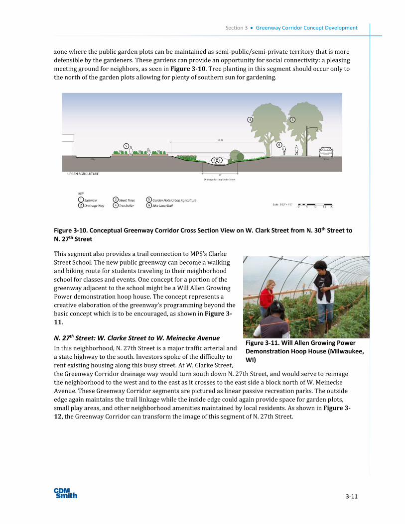
Section 3 Greenway Corridor Concept Development
3-11
zone where the public garden plots can be maintained as semi-public/semi-private territory that is more
defensible by the gardeners. These gardens can provide an opportunity for social connectivity: a pleasing
meeting ground for neighbors, as seen in Figure 3-10. Tree planting in this segment should occur only to
the north of the garden plots allowing for plenty of southern sun for gardening.
Figure 3-10. Conceptual Greenway Corridor Cross Section View on W. Clark Street from N. 30th Street to N. 27th Street
This segment also provides a trail connection to MPS’s Clarke
Street School. The new public greenway can become a walking
and biking route for students traveling to their neighborhood
school for classes and events. One concept for a portion of the
greenway adjacent to the school might be a Will Allen Growing
Power demonstration hoop house. The concept represents a
creative elaboration of the greenway’s programming beyond the
basic concept which is to be encouraged, as shown in Figure 3-
11.
N. 27th Street: W. Clarke Street to W. Meinecke Avenue
In this neighborhood, N. 27th Street is a major traffic arterial and
a state highway to the south. Investors spoke of the difficulty to
rent existing housing along this busy street. At W. Clarke Street,
the Greenway Corridor drainage way would turn south down N. 27th Street, and would serve to reimage
the neighborhood to the west and to the east as it crosses to the east side a block north of W. Meinecke
Avenue. These Greenway Corridor segments are pictured as linear passive recreation parks. The outside
edge again maintains the trail linkage while the inside edge could again provide space for garden plots,
small play areas, and other neighborhood amenities maintained by local residents. As shown in Figure 3-
12, the Greenway Corridor can transform the image of this segment of N. 27th Street.
Figure 3-11. Will Allen Growing Power Demonstration Hoop House (Milwaukee, WI)
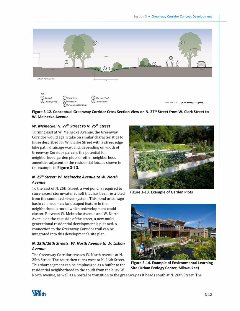
Section 3 Greenway Corridor Concept Development
3-12
Figure 3-12. Conceptual Greenway Corridor Cross Section View on N. 27th Street from W. Clark Street to W. Meinecke Avenue
W. Meinecke: N. 27th Street to N. 25th Street
Turning east at W. Meinecke Avenue, the Greenway
Corridor would again take on similar characteristics to
those described for W. Clarke Street with a street edge
bike path, drainage way, and, depending on width of
Greenway Corridor parcels, the potential for
neighborhood garden plots or other neighborhood
amenities adjacent to the residential lots, as shown in
the example in Figure 3-13.
N. 25th Street: W. Meinecke Avenue to W. North Avenue
To the east of N. 25th Street, a wet pond is required to
store excess stormwater runoff that has been restricted
from the combined sewer system. This pond or storage
basin can become a landscaped feature in the
neighborhood around which redevelopment could
cluster. Between W. Meinecke Avenue and W. North
Avenue on the east side of the street, a new multi-
generational residential development is planned. A
connection to the Greenway Corridor trail can be
integrated into this development’s site plan.
N. 25th/26th Streets: W. North Avenue to W. Lisbon Avenue
The Greenway Corridor crosses W. North Avenue at N.
25th Street. The route then turns west to N. 26th Street.
This short segment can be emphasized as a buffer to the
residential neighborhood to the south from the busy W.
North Avenue, as well as a portal or transition to the greenway as it heads south at N. 26th Street. The
Figure 3-14. Example of Environmental Learning Site (Urban Ecology Center, Milwaukee)
Figure 3-13. Example of Garden Plots
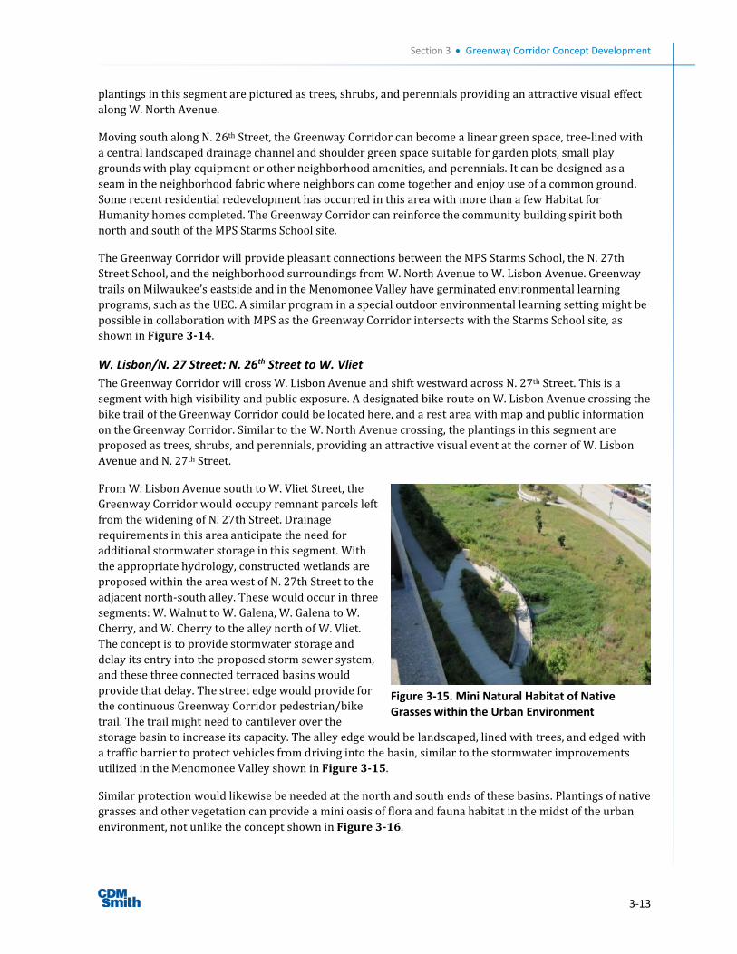
Section 3 Greenway Corridor Concept Development
3-13
plantings in this segment are pictured as trees, shrubs, and perennials providing an attractive visual effect
along W. North Avenue.
Moving south along N. 26th Street, the Greenway Corridor can become a linear green space, tree-lined with
a central landscaped drainage channel and shoulder green space suitable for garden plots, small play
grounds with play equipment or other neighborhood amenities, and perennials. It can be designed as a
seam in the neighborhood fabric where neighbors can come together and enjoy use of a common ground.
Some recent residential redevelopment has occurred in this area with more than a few Habitat for
Humanity homes completed. The Greenway Corridor can reinforce the community building spirit both
north and south of the MPS Starms School site.
The Greenway Corridor will provide pleasant connections between the MPS Starms School, the N. 27th
Street School, and the neighborhood surroundings from W. North Avenue to W. Lisbon Avenue. Greenway
trails on Milwaukee’s eastside and in the Menomonee Valley have germinated environmental learning
programs, such as the UEC. A similar program in a special outdoor environmental learning setting might be
possible in collaboration with MPS as the Greenway Corridor intersects with the Starms School site, as
shown in Figure 3-14.
W. Lisbon/N. 27 Street: N. 26th Street to W. Vliet
The Greenway Corridor will cross W. Lisbon Avenue and shift westward across N. 27th Street. This is a
segment with high visibility and public exposure. A designated bike route on W. Lisbon Avenue crossing the
bike trail of the Greenway Corridor could be located here, and a rest area with map and public information
on the Greenway Corridor. Similar to the W. North Avenue crossing, the plantings in this segment are
proposed as trees, shrubs, and perennials, providing an attractive visual event at the corner of W. Lisbon
Avenue and N. 27th Street.
From W. Lisbon Avenue south to W. Vliet Street, the
Greenway Corridor would occupy remnant parcels left
from the widening of N. 27th Street. Drainage
requirements in this area anticipate the need for
additional stormwater storage in this segment. With
the appropriate hydrology, constructed wetlands are
proposed within the area west of N. 27th Street to the
adjacent north-south alley. These would occur in three
segments: W. Walnut to W. Galena, W. Galena to W.
Cherry, and W. Cherry to the alley north of W. Vliet.
The concept is to provide stormwater storage and
delay its entry into the proposed storm sewer system,
and these three connected terraced basins would
provide that delay. The street edge would provide for
the continuous Greenway Corridor pedestrian/bike
trail. The trail might need to cantilever over the
storage basin to increase its capacity. The alley edge would be landscaped, lined with trees, and edged with
a traffic barrier to protect vehicles from driving into the basin, similar to the stormwater improvements
utilized in the Menomonee Valley shown in Figure 3-15.
Similar protection would likewise be needed at the north and south ends of these basins. Plantings of native
grasses and other vegetation can provide a mini oasis of flora and fauna habitat in the midst of the urban
environment, not unlike the concept shown in Figure 3-16.
Figure 3-15. Mini Natural Habitat of Native Grasses within the Urban Environment
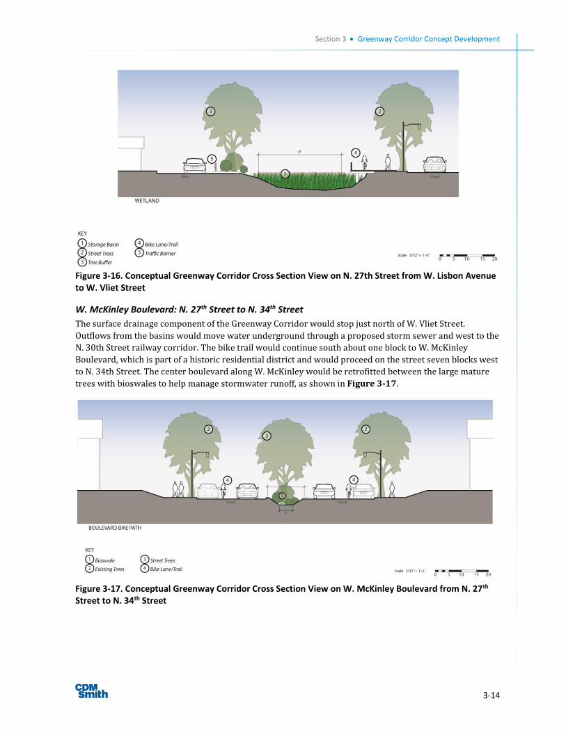
Section 3 Greenway Corridor Concept Development
3-14
Figure 3-16. Conceptual Greenway Corridor Cross Section View on N. 27th Street from W. Lisbon Avenue to W. Vliet Street
W. McKinley Boulevard: N. 27th Street to N. 34th Street
The surface drainage component of the Greenway Corridor would stop just north of W. Vliet Street.
Outflows from the basins would move water underground through a proposed storm sewer and west to the
N. 30th Street railway corridor. The bike trail would continue south about one block to W. McKinley
Boulevard, which is part of a historic residential district and would proceed on the street seven blocks west
to N. 34th Street. The center boulevard along W. McKinley would be retrofitted between the large mature
trees with bioswales to help manage stormwater runoff, as shown in Figure 3-17.
Figure 3-17. Conceptual Greenway Corridor Cross Section View on W. McKinley Boulevard from N. 27th Street to N. 34th Street
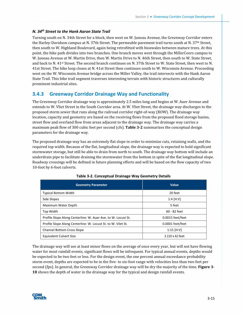
Section 3 Greenway Corridor Concept Development
3-15
N. 34th Street to the Hank Aaron State Trail
Turning south on N. 34th Street for a block, then west on W. Juneau Avenue, the Greenway Corridor enters
the Harley-Davidson campus at N. 37th Street. The permeable pavement trail turns south at N. 37th Street,
then south to W. Highland Boulevard, again being retrofitted with bioswales between mature trees. At this
point, the bike path divides into two branches. One branch moves west through the MillerCoors campus to
W. Juneau Avenue at W. Martin Drive, then W. Martin Drive to N. 46th Street, then south to W. State Street,
and back to N. 41st Street. The second branch continues on N. 37th Street to W. State Street, then west to N.
41st Street. The bike loop closes at N. 41st Street then continues south to W. Wisconsin Avenue. Proceeding
west on the W. Wisconsin Avenue bridge across the Miller Valley, the trail intersects with the Hank Aaron
State Trail. This bike trail segment traverses interesting terrain with historic structures and culturally
prominent industrial sites.
3.4.3 Greenway Corridor Drainage Way and Functionality
The Greenway Corridor drainage way is approximately 2.5 miles long and begins at W. Auer Avenue and
extends to W. Vliet Street in the South Corridor area. At W. Vliet Street, the drainage way discharges to the
proposed storm sewer that runs along the railroad corridor right-of-way (ROW). The drainage way
location, capacity and geometry are based on the receiving flows from the proposed flood storage basins,
street flow and overland flow from areas adjacent to the drainage way. The drainage way carries a
maximum peak flow of 300 cubic feet per second (cfs). Table 3-2 summarizes the conceptual design
parameters for the drainage way.
The proposed drainage way has an extremely flat slope in order to minimize cuts, retaining walls, and the
required top width. Because of the flat, longitudinal slope, the drainage way is expected to hold significant
stormwater storage, but still be able to drain from north to south. The drainage way bottom will include an
underdrain pipe to facilitate draining the stormwater from the bottom in spite of the flat longitudinal slope.
Roadway crossings will be defined in future planning efforts and will be based on the flow capacity of two
10-foot by 6-foot culverts.
Table 3-2. Conceptual Drainage Way Geometry Details
Geometry Parameter Value
Typical Bottom Width 20 feet
Side Slopes 1:4 [H:V]
Maximum Water Depth 5 feet
Top Width 60 - 82 feet
Profile Slope Along Centerline: W. Auer Ave. to W. Locust St. 0.0015 feet/feet
Profile Slope Along Centerline: W. Locust St. to W. Vilet St. 0.0001 feet/feet
Channel Bottom Cross Slope 1:15 [H:V]
Equivalent Culvert Size 2 (10 x 6) feet
The drainage way will see at least minor flows on the average of once every year, but will not have flowing
water for most rainfall events, significant flows will be infrequent. For typical annual events, depths would
be expected to be two feet or less. For the design event, the one percent annual exceedance probability
storm event, depths are expected to be in the five- to six-foot range with velocities less than two feet per
second (fps). In general, the Greenway Corridor drainage way will be dry the majority of the time. Figure 3-
18 shows the depth of water in the drainage way for the typical and design rainfall events.
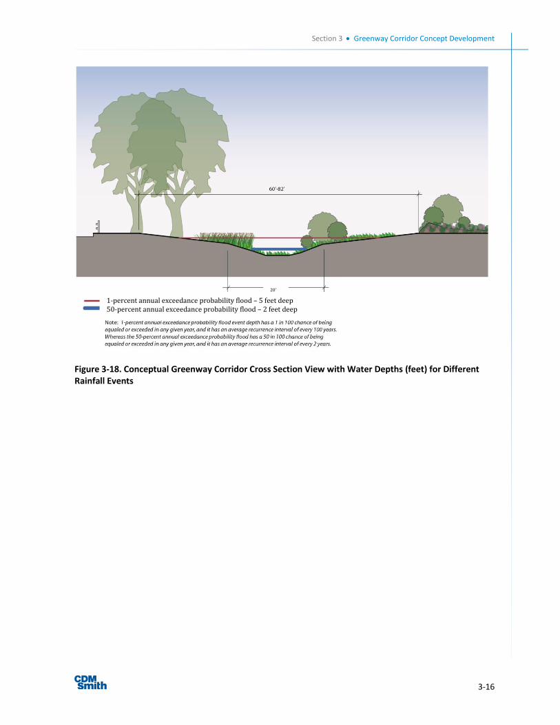
Section 3 Greenway Corridor Concept Development
3-16
Figure 3-18. Conceptual Greenway Corridor Cross Section View with Water Depths (feet) for Different Rainfall Events
1-percent annual exceedance probability flood – 5 feet deep 50-percent annual exceedance probability flood – 2 feet deep
20’
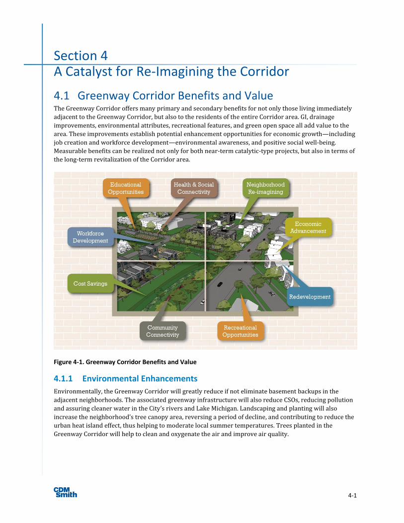
4-1
Section 4 A Catalyst for Re-Imagining the Corridor
4.1 Greenway Corridor Benefits and Value The Greenway Corridor offers many primary and secondary benefits for not only those living immediately
adjacent to the Greenway Corridor, but also to the residents of the entire Corridor area. GI, drainage
improvements, environmental attributes, recreational features, and green open space all add value to the
area. These improvements establish potential enhancement opportunities for economic growth—including
job creation and workforce development—environmental awareness, and positive social well-being.
Measurable benefits can be realized not only for both near-term catalytic-type projects, but also in terms of
the long-term revitalization of the Corridor area.
Figure 4-1. Greenway Corridor Benefits and Value
4.1.1 Environmental Enhancements
Environmentally, the Greenway Corridor will greatly reduce if not eliminate basement backups in the
adjacent neighborhoods. The associated greenway infrastructure will also reduce CSOs, reducing pollution
and assuring cleaner water in the City’s rivers and Lake Michigan. Landscaping and planting will also
increase the neighborhood’s tree canopy area, reversing a period of decline, and contributing to reduce the
urban heat island effect, thus helping to moderate local summer temperatures. Trees planted in the
Greenway Corridor will help to clean and oxygenate the air and improve air quality.
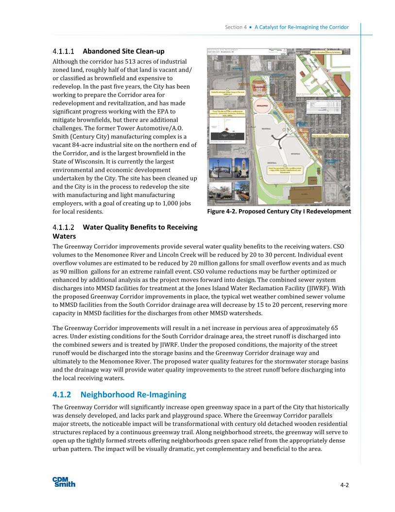
Section 4 A Catalyst for Re-Imagining the Corridor
4-2
Abandoned Site Clean-up
Although the corridor has 513 acres of industrial
zoned land, roughly half of that land is vacant and/
or classified as brownfield and expensive to
redevelop. In the past five years, the City has been
working to prepare the Corridor area for
redevelopment and revitalization, and has made
significant progress working with the EPA to
mitigate brownfields, but there are additional
challenges. The former Tower Automotive/A.O.
Smith (Century City) manufacturing complex is a
vacant 84-acre industrial site on the northern end of
the Corridor, and is the largest brownfield in the
State of Wisconsin. It is currently the largest
environmental and economic development
undertaken by the City. The site has been cleaned up
and the City is in the process to redevelop the site
with manufacturing and light manufacturing
employers, with a goal of creating up to 1,000 jobs
for local residents.
Water Quality Benefits to Receiving Waters
The Greenway Corridor improvements provide several water quality benefits to the receiving waters. CSO
volumes to the Menomonee River and Lincoln Creek will be reduced by 20 to 30 percent. Individual event
overflow volumes are estimated to be reduced by 20 million gallons for small overflow events and as much
as 90 million gallons for an extreme rainfall event. CSO volume reductions may be further optimized or
enhanced by additional analysis as the project moves forward into design. The combined sewer system
discharges into MMSD facilities for treatment at the Jones Island Water Reclamation Facility (JIWRF). With
the proposed Greenway Corridor improvements in place, the typical wet weather combined sewer volume
to MMSD facilities from the South Corridor drainage area will decrease by 15 to 20 percent, reserving more
capacity in MMSD facilities for the discharges from other MMSD watersheds.
The Greenway Corridor improvements will result in a net increase in pervious area of approximately 65
acres. Under existing conditions for the South Corridor drainage area, the street runoff is discharged into
the combined sewers and is treated by JIWRF. Under the proposed conditions, the majority of the street
runoff would be discharged into the storage basins and the Greenway Corridor drainage way and
ultimately to the Menomonee River. The proposed water quality features for the stormwater storage basins
and the drainage way will provide water quality improvements to the street runoff before discharging into
the local receiving waters.
4.1.2 Neighborhood Re-Imagining
The Greenway Corridor will significantly increase open greenway space in a part of the City that historically
was densely developed, and lacks park and playground space. Where the Greenway Corridor parallels
major streets, the noticeable impact will be transformational with century old detached wooden residential
structures replaced by a continuous greenway trail. Along neighborhood streets, the greenway will serve to
open up the tightly formed streets offering neighborhoods green space relief from the appropriately dense
urban pattern. The impact will be visually dramatic, yet complementary and beneficial to the area.
Figure 4-2. Proposed Century City I Redevelopment
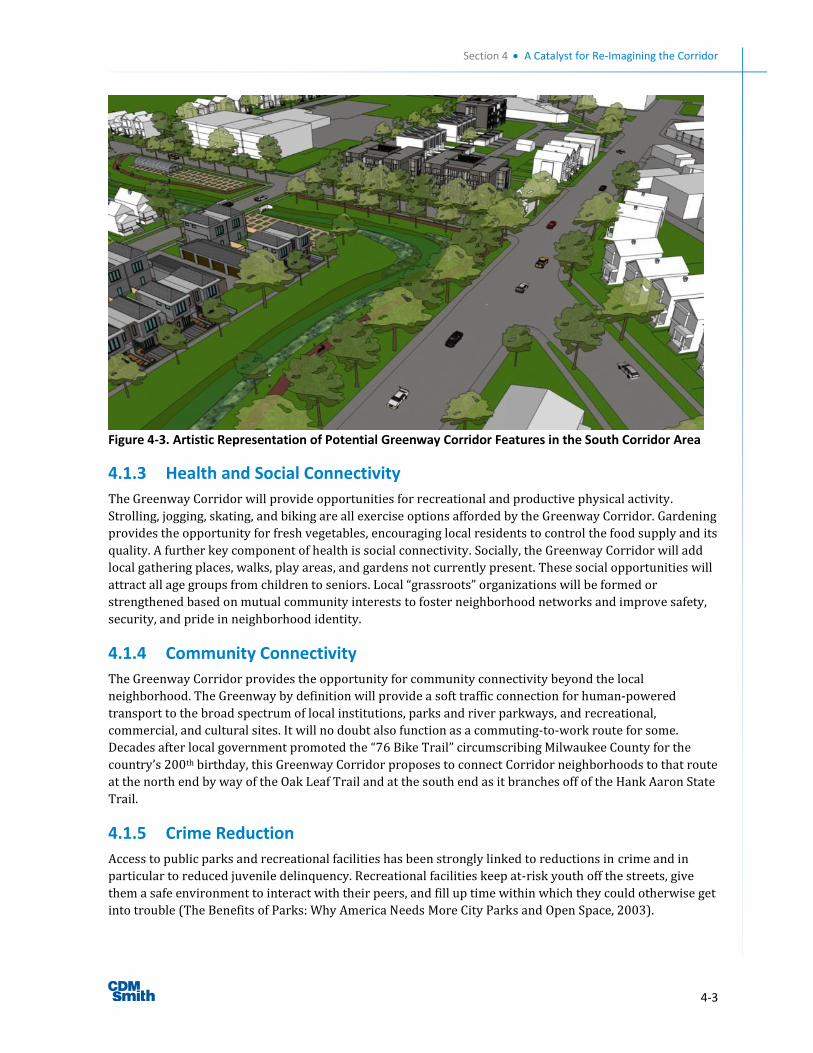
Section 4 A Catalyst for Re-Imagining the Corridor
4-3
Figure 4-3. Artistic Representation of Potential Greenway Corridor Features in the South Corridor Area
4.1.3 Health and Social Connectivity
The Greenway Corridor will provide opportunities for recreational and productive physical activity.
Strolling, jogging, skating, and biking are all exercise options afforded by the Greenway Corridor. Gardening
provides the opportunity for fresh vegetables, encouraging local residents to control the food supply and its
quality. A further key component of health is social connectivity. Socially, the Greenway Corridor will add
local gathering places, walks, play areas, and gardens not currently present. These social opportunities will
attract all age groups from children to seniors. Local “grassroots” organizations will be formed or
strengthened based on mutual community interests to foster neighborhood networks and improve safety,
security, and pride in neighborhood identity.
4.1.4 Community Connectivity
The Greenway Corridor provides the opportunity for community connectivity beyond the local
neighborhood. The Greenway by definition will provide a soft traffic connection for human-powered
transport to the broad spectrum of local institutions, parks and river parkways, and recreational,
commercial, and cultural sites. It will no doubt also function as a commuting-to-work route for some.
Decades after local government promoted the “76 Bike Trail” circumscribing Milwaukee County for the
country’s 200th birthday, this Greenway Corridor proposes to connect Corridor neighborhoods to that route
at the north end by way of the Oak Leaf Trail and at the south end as it branches off of the Hank Aaron State
Trail.
4.1.5 Crime Reduction
Access to public parks and recreational facilities has been strongly linked to reductions in crime and in
particular to reduced juvenile delinquency. Recreational facilities keep at-risk youth off the streets, give
them a safe environment to interact with their peers, and fill up time within which they could otherwise get
into trouble (The Benefits of Parks: Why America Needs More City Parks and Open Space, 2003).
Section 4 A Catalyst for Re-Imagining the Corridor
4-4
In Fort Myers, Florida, police documented a 28 percent drop in juvenile arrests after the city began the
STARS (Success through Academics and Recreational Support) Program in 1990. Fort Myers built a new
recreation center in the heart of a low-income community to support STARS. Young people’s school grades
also improved significantly. Importantly, building parks costs a fraction of what it costs to build new
prisons and increase police-force size (The Benefits of Parks: Why America Needs More City Parks and
Open Space, 2003).
Many communities have reported success with “midnight basketball” programs, keeping courts open late at
night to give youths an alternative to finding trouble. Over a one-year period, Kansas City reported a 25
percent decrease in arrests of juveniles in areas where midnight basketball programs were offered. In Fort
Worth, Texas, crime dropped 28 percent within a one-mile radius of community centers where midnight
basketball was offered. In the areas around five other Fort Worth community centers where the programs
were not offered, crime rose an average of 39 percent during the same period (The Benefits of Parks: Why
America Needs More City Parks and Open Space, 2003).
Research supports the widely held belief that community involvement in neighborhood parks is correlated
with lower levels of crime. The Project on Human Development in Chicago Neighborhoods studied the
impact of “collective efficacy,” which it defined as “cohesion among neighborhood residents combined with
shared expectations for informal social control of public space.” The study found that “in neighborhoods
where collective efficacy was strong, rates of violence were low, regardless of sociodemographic
composition and the amount of disorder observed. Collective efficacy also appears to deter disorder: Where
it was strong, observed levels of physical and social disorder were low (The Benefits of Parks: Why America
Needs More City Parks and Open Space, 2003).
4.1.6 Economic Advancement
Economically, the Greenway Corridor will add value in views and recreational amenities to positively
impact adjacent and nearby property values. These are typical considerations and incrementally increase
property appraisals, building equity for local property owners and increasing the tax base for the City. The
Greenway also positively affects pride of ownership for adjacent property owners, encouraging long-term
investment in these properties and, in turn, further increasing the City’s tax base. For the urban gardeners,
annual food costs can be reduced and greenway maintenance will provide meaningful employment for
some. Corridor improvements will contribute to both short-term and long-term job creation, with
economic advancement helping to fuel redevelopment and increased value across the Corridor.
At the macro scale, an investment of the magnitude of the Greenway Corridor in this neighborhood is a
once-in-a-century opportunity that provides an unparalleled investment in the area that can be leveraged
for significant, long-term economic benefits.
Increased Property Values
Studies show that greenways and trails have a proven positive impact on property values. For example, a
study of the impacts of “greenway belts” on neighborhood property values in Boulder, CO, revealed the
aggregate property value for one neighborhood was approximately $5.4 million greater than if there had
been no greenway belt constructed. This results in approximately $500,000 of additional property tax
revenue for the City of Boulder (National Park Service, 1995).
Case studies provide a range of increased value that greenways can bring to adjacent property. Notable
facts for successful greenways include:
The preponderance of studies has revealed that excellent parks tend to add 15 percent to the value
of a proximate dwelling (Harnik & Welle, 2009).
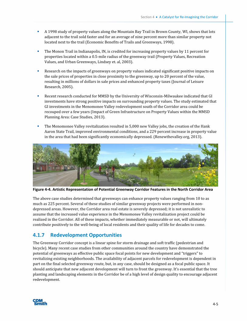
Section 4 A Catalyst for Re-Imagining the Corridor
4-5
A 1998 study of property values along the Mountain Bay Trail in Brown County, WI, shows that lots
adjacent to the trail sold faster and for an average of nine percent more than similar property not
located next to the trail (Economic Benefits of Trails and Greenways, 1998).
The Monon Trail in Indianapolis, IN, is credited for increasing property values by 11 percent for
properties located within a 0.5-mile radius of the greenway trail (Property Values, Recreation
Values, and Urban Greenways, Lindsey et. al, 2003).
Research on the impacts of greenways on property values indicated significant positive impacts on
the sale prices of properties in close proximity to the greenway, up to 20 percent of the value,
resulting in millions of dollars in sale prices and enhanced property taxes (Journal of Leisure
Research, 2005).
Recent research conducted for MMSD by the University of Wisconsin-Milwaukee indicated that GI
investments have strong positive impacts on surrounding property values. The study estimated that
GI investments in the Menomonee Valley redevelopment south of the Corridor area could be
recouped over a few years (Impact of Green Infrastructure on Property Values within the MMSD
Planning Area: Case Studies, 2013).
The Menomonee Valley revitalization resulted in 5,000 new Valley jobs, the creation of the Hank
Aaron State Trail, improved environmental conditions, and a 229 percent increase in property value
in the area that had been significantly economically depressed. (Renewthevalley.org, 2013).
Figure 4-4. Artistic Representation of Potential Greenway Corridor Features in the North Corridor Area
The above case studies determined that greenways can enhance property values ranging from 10 to as
much as 225 percent. Several of these studies of similar greenway projects were performed in non-
depressed areas. However, the Corridor area real estate is severely depressed; it is not unrealistic to
assume that the increased value experience in the Menomonee Valley revitalization project could be
realized in the Corridor. All of these impacts, whether immediately measurable or not, will ultimately
contribute positively to the well-being of local residents and their quality of life for decades to come.
4.1.7 Redevelopment Opportunities
The Greenway Corridor concept is a linear spine for storm drainage and soft traffic (pedestrian and
bicycle). Many recent case studies from other communities around the country have demonstrated the
potential of greenways as effective public space focal points for new development and “triggers” to
revitalizing existing neighborhoods. The availability of adjacent parcels for redevelopment is dependent in
part on the final selected greenway route, but, in any case, should be designed as a focal public space. It
should anticipate that new adjacent development will turn to front the greenway. It’s essential that the tree
planting and landscaping elements in the Corridor be of a high level of design quality to encourage adjacent
redevelopment.
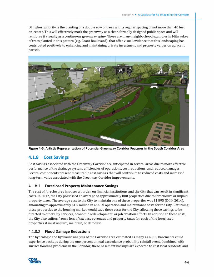
Section 4 A Catalyst for Re-Imagining the Corridor
4-6
Of highest priority is the planting of a double row of trees with a regular spacing of not more than 40 feet
on-center. This will effectively mark the greenway as a clear, formally designed public space and will
reinforce it visually as a continuous greenway spine. There are many neighborhood examples in Milwaukee
of trees planted in this pattern (e.g. Grant Boulevard), that offer visual evidence that this landscaping has
contributed positively to enhancing and maintaining private investment and property values on adjacent
parcels.
Figure 4-5. Artistic Representation of Potential Greenway Corridor Features in the South Corridor Area
4.1.8 Cost Savings
Cost savings associated with the Greenway Corridor are anticipated in several areas due to more effective
performance of the drainage system, efficiencies of operations, cost reductions, and reduced damages.
Several components present measurable cost savings that will contribute to reduced costs and increased
long-term value associated with the Greenway Corridor improvements.
Foreclosed Property Maintenance Savings
The cost of foreclosures imposes a burden on financial institutions and the City that can result in significant
costs. In 2012, the City possessed an average of approximately 800 properties due to foreclosure or unpaid
property taxes. The average cost to the City to maintain one of these properties was $1,895 (DCD, 2014),
amounting to approximately $1.5 million in annual operation and maintenance costs for the City. Returning
these properties to the housing market would save these costs for the City, allowing these savings to be
directed to other City services, economic redevelopment, or job creation efforts. In addition to these costs,
the City also suffers from a loss of tax base revenues and property taxes for each of the foreclosed
properties it must acquire, maintain, or demolish.
Flood Damage Reductions
The hydrologic and hydraulic analysis of the Corridor area estimated as many as 4,000 basements could
experience backups during the one percent annual exceedance probability rainfall event. Combined with
surface flooding problems in the Corridor, these basement backups are expected to cost local residents and
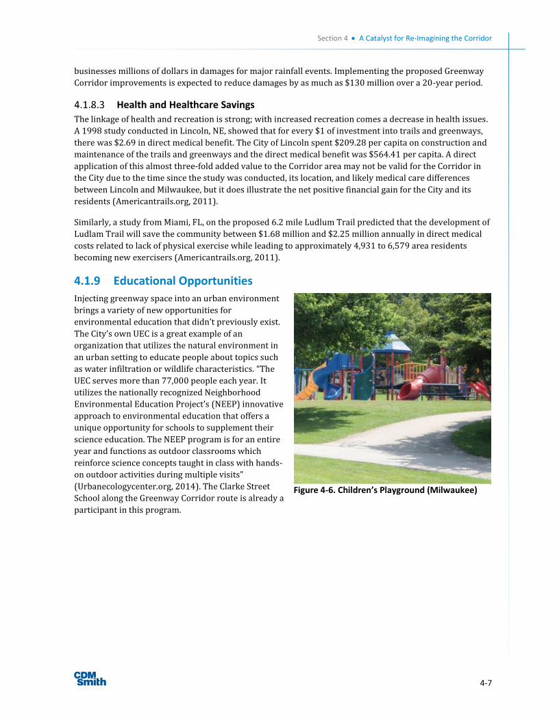
Section 4 A Catalyst for Re-Imagining the Corridor
4-7
businesses millions of dollars in damages for major rainfall events. Implementing the proposed Greenway
Corridor improvements is expected to reduce damages by as much as $130 million over a 20-year period.
Health and Healthcare Savings
The linkage of health and recreation is strong; with increased recreation comes a decrease in health issues.
A 1998 study conducted in Lincoln, NE, showed that for every $1 of investment into trails and greenways,
there was $2.69 in direct medical benefit. The City of Lincoln spent $209.28 per capita on construction and
maintenance of the trails and greenways and the direct medical benefit was $564.41 per capita. A direct
application of this almost three-fold added value to the Corridor area may not be valid for the Corridor in
the City due to the time since the study was conducted, its location, and likely medical care differences
between Lincoln and Milwaukee, but it does illustrate the net positive financial gain for the City and its
residents (Americantrails.org, 2011).
Similarly, a study from Miami, FL, on the proposed 6.2 mile Ludlum Trail predicted that the development of
Ludlam Trail will save the community between $1.68 million and $2.25 million annually in direct medical
costs related to lack of physical exercise while leading to approximately 4,931 to 6,579 area residents
becoming new exercisers (Americantrails.org, 2011).
4.1.9 Educational Opportunities
Injecting greenway space into an urban environment
brings a variety of new opportunities for
environmental education that didn’t previously exist.
The City’s own UEC is a great example of an
organization that utilizes the natural environment in
an urban setting to educate people about topics such
as water infiltration or wildlife characteristics. “The
UEC serves more than 77,000 people each year. It
utilizes the nationally recognized Neighborhood
Environmental Education Project’s (NEEP) innovative
approach to environmental education that offers a
unique opportunity for schools to supplement their
science education. The NEEP program is for an entire
year and functions as outdoor classrooms which
reinforce science concepts taught in class with hands-
on outdoor activities during multiple visits”
(Urbanecologycenter.org, 2014). The Clarke Street
School along the Greenway Corridor route is already a
participant in this program.
Figure 4-6. Children’s Playground (Milwaukee)
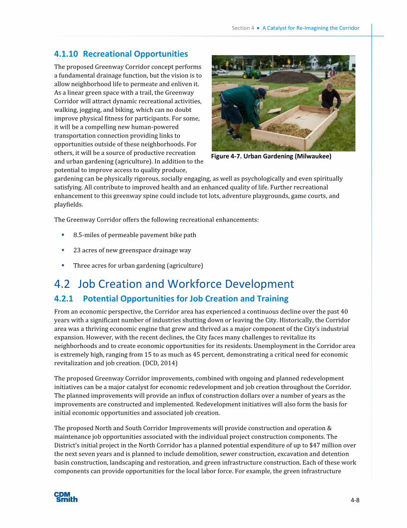
Section 4 A Catalyst for Re-Imagining the Corridor
4-8
4.1.10 Recreational Opportunities
The proposed Greenway Corridor concept performs
a fundamental drainage function, but the vision is to
allow neighborhood life to permeate and enliven it.
As a linear green space with a trail, the Greenway
Corridor will attract dynamic recreational activities,
walking, jogging, and biking, which can no doubt
improve physical fitness for participants. For some,
it will be a compelling new human-powered
transportation connection providing links to
opportunities outside of these neighborhoods. For
others, it will be a source of productive recreation
and urban gardening (agriculture). In addition to the
potential to improve access to quality produce,
gardening can be physically rigorous, socially engaging, as well as psychologically and even spiritually
satisfying. All contribute to improved health and an enhanced quality of life. Further recreational
enhancement to this greenway spine could include tot lots, adventure playgrounds, game courts, and
playfields.
The Greenway Corridor offers the following recreational enhancements:
8.5-miles of permeable pavement bike path
23 acres of new greenspace drainage way
Three acres for urban gardening (agriculture)
4.2 Job Creation and Workforce Development 4.2.1 Potential Opportunities for Job Creation and Training
From an economic perspective, the Corridor area has experienced a continuous decline over the past 40
years with a significant number of industries shutting down or leaving the City. Historically, the Corridor
area was a thriving economic engine that grew and thrived as a major component of the City’s industrial
expansion. However, with the recent declines, the City faces many challenges to revitalize its
neighborhoods and to create economic opportunities for its residents. Unemployment in the Corridor area
is extremely high, ranging from 15 to as much as 45 percent, demonstrating a critical need for economic
revitalization and job creation. (DCD, 2014)
The proposed Greenway Corridor improvements, combined with ongoing and planned redevelopment
initiatives can be a major catalyst for economic redevelopment and job creation throughout the Corridor.
The planned improvements will provide an influx of construction dollars over a number of years as the
improvements are constructed and implemented. Redevelopment initiatives will also form the basis for
initial economic opportunities and associated job creation.
The proposed North and South Corridor Improvements will provide construction and operation &
maintenance job opportunities associated with the individual project construction components. The
District’s initial project in the North Corridor has a planned potential expenditure of up to $47 million over
the next seven years and is planned to include demolition, sewer construction, excavation and detention
basin construction, landscaping and restoration, and green infrastructure construction. Each of these work
components can provide opportunities for the local labor force. For example, the green infrastructure
Figure 4-7. Urban Gardening (Milwaukee)
Section 4 A Catalyst for Re-Imagining the Corridor
4-9
related work offers potential positions for general construction labor, landscaping work, and post
construction basic plant care that can create basic occupational competency and can be a stepping stone to
a long term, sustainable position in construction or other related trades.
The conceptual level construction, operations and maintenance cost estimates of the Greenway Corridor
improvements were used to project estimates of short- and long-term job creation in the Corridor area.
Using IMPLAN software, WHEDA collaborated with the University of Wisconsin-Extension Center for
Community and Economic Development to estimate potential job creation associated with the Greenway
Corridor improvements. These estimates indicate that in the short term, a total of 1,300 jobs are
anticipated to be associated with the construction of the Greenway Corridor and drainage improvements
(WHEDA, 2014). An additional 70 long-term jobs are projected to be needed for the operations and
maintenance of the Greenway Corridor improvements.
Beyond the near-term construction projects, the City has initiated several initiatives to revitalize the area,
the most significant being the Century City Business Park in the North Corridor. This modern industrial
park redevelopment project is the centerpiece for a broader revitalization of the entire Corridor and has
recently broke ground on its first development parcel. It is anticipated that when the Century City Business
Park is fully developed, it will employ up to 1,000 workers in the Corridor area (City of Milwaukee DCD,
2014).
4.2.2 Job Creation and Workforce Development Initiatives
Taking full advantage of these potential job creation opportunities and connecting them with the local
workforce is a crucial step to ensure meaningful job creation. Several institutions and programs exist to
ensure that the development of the workforce occurs to its full potential.
MMSD, the City, Milwaukee County, the 30th Street Industrial Corridor Corporation (The Corridor), the
Milwaukee Area Workforce Investment Board (MAWIB), WRTP/BIG STEP, and WHEDA all have a potential
role or contribution in workforce development for the Corridor area.
MMSD, the City, Milwaukee County and WHEDA
MMSD, the City, Milwaukee County and WHEDA all have the authority to take responsibility for project
construction or development by funding or assuming ownership of infrastructure construction projects or
developments/redevelopments in the Corridor area. Their responsibility for, and involvement in, a project
enables them to define certain goals or requirements to facilitate workforce development on their projects
through their project specifications or bid documents. Each of these entities collaborates with other
partners, such as the MAWIB to implement a strategy to maximize the potential opportunities for
workforce development and job creation in the Corridor area.
30th Street Industrial Corridor Corporation (The Corridor)
The Corridor has recently initiated a “Local People-Local Jobs” program to connect the local workforce with
area jobs. The Corridor already works with over 150 employers that summarize and distribute new job
opportunities, and also research other nearby job openings that might be suitable for corridor
residents. These jobs are then advertised to local people via email, website and community outreach
meetings (churches, block clubs, community associations, etc). Often workers are referred to MAWIB for
help with resumes and training. The Corridor has one staffer dedicated to the Local People – Local Jobs
initiative, which is proving to be very popular.
Milwaukee Area Workforce Investment Board (MAWIB)
The primary facilitator and focal point for workforce development in the Milwaukee area is the Milwaukee
Area Workforce Investment Board (MAWIB). MAWIB is a nonprofit organization with the mission of
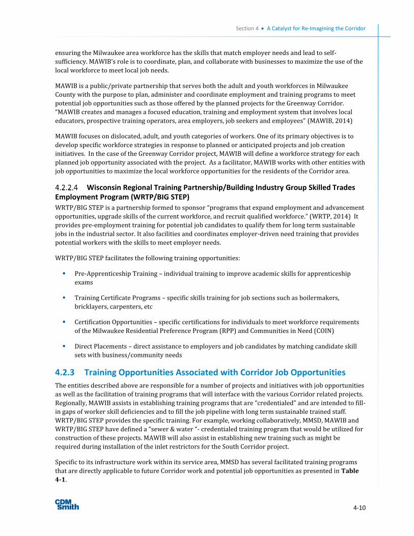
Section 4 A Catalyst for Re-Imagining the Corridor
4-10
ensuring the Milwaukee area workforce has the skills that match employer needs and lead to self-
sufficiency. MAWIB’s role is to coordinate, plan, and collaborate with businesses to maximize the use of the
local workforce to meet local job needs.
MAWIB is a public/private partnership that serves both the adult and youth workforces in Milwaukee
County with the purpose to plan, administer and coordinate employment and training programs to meet
potential job opportunities such as those offered by the planned projects for the Greenway Corridor.
“MAWIB creates and manages a focused education, training and employment system that involves local
educators, prospective training operators, area employers, job seekers and employees” (MAWIB, 2014)
MAWIB focuses on dislocated, adult, and youth categories of workers. One of its primary objectives is to
develop specific workforce strategies in response to planned or anticipated projects and job creation
initiatives. In the case of the Greenway Corridor project, MAWIB will define a workforce strategy for each
planned job opportunity associated with the project. As a facilitator, MAWIB works with other entities with
job opportunities to maximize the local workforce opportunities for the residents of the Corridor area.
Wisconsin Regional Training Partnership/Building Industry Group Skilled Trades Employment Program (WRTP/BIG STEP)
WRTP/BIG STEP is a partnership formed to sponsor “programs that expand employment and advancement
opportunities, upgrade skills of the current workforce, and recruit qualified workforce.” (WRTP, 2014) It
provides pre-employment training for potential job candidates to qualify them for long term sustainable
jobs in the industrial sector. It also facilities and coordinates employer-driven need training that provides
potential workers with the skills to meet employer needs.
WRTP/BIG STEP facilitates the following training opportunities:
Pre-Apprenticeship Training – individual training to improve academic skills for apprenticeship
exams
Training Certificate Programs – specific skills training for job sections such as boilermakers,
bricklayers, carpenters, etc
Certification Opportunities – specific certifications for individuals to meet workforce requirements
of the Milwaukee Residential Preference Program (RPP) and Communities in Need (COIN)
Direct Placements – direct assistance to employers and job candidates by matching candidate skill
sets with business/community needs
4.2.3 Training Opportunities Associated with Corridor Job Opportunities
The entities described above are responsible for a number of projects and initiatives with job opportunities
as well as the facilitation of training programs that will interface with the various Corridor related projects.
Regionally, MAWIB assists in establishing training programs that are “credentialed” and are intended to fill-
in gaps of worker skill deficiencies and to fill the job pipeline with long term sustainable trained staff.
WRTP/BIG STEP provides the specific training. For example, working collaboratively, MMSD, MAWIB and
WRTP/BIG STEP have defined a “sewer & water “- credentialed training program that would be utilized for
construction of these projects. MAWIB will also assist in establishing new training such as might be
required during installation of the inlet restrictors for the South Corridor project.
Specific to its infrastructure work within its service area, MMSD has several facilitated training programs
that are directly applicable to future Corridor work and potential job opportunities as presented in Table
4-1.
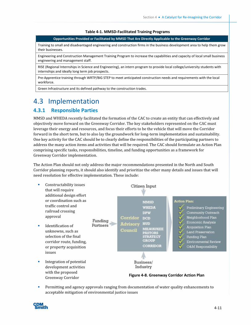
Section 4 A Catalyst for Re-Imagining the Corridor
4-11
Table 4-1. MMSD-Facilitated Training Programs
Opportunities Provided or Facilitated by MMSD That Are Directly Applicable to the Greenway Corridor
Training to small and disadvantaged engineering and construction firms in the business development area to help them grow their businesses.
Engineering and Construction Management Training Program to increase the capabilities and capacity of local small business engineering and management staff.
RISE (Regional Internships in Science and Engineering), an intern program to provide local college/university students with internships and ideally long term job prospects.
Pre-Apprentice training through WRTP/BIG STEP to meet anticipated construction needs and requirements with the local workforce.
Green Infrastructure and its defined pathway to the construction trades.
4.3 Implementation 4.3.1 Responsible Parties
MMSD and WHEDA recently facilitated the formation of the CAC to create an entity that can effectively and
objectively move forward on the Greenway Corridor. The key stakeholders represented on the CAC must
leverage their energy and resources, and focus their efforts to be the vehicle that will move the Corridor
forward in the short term, but to also lay the groundwork for long-term implementation and sustainability.
One key activity for the CAC should be to clearly define the responsibilities of the participating partners to
address the many action items and activities that will be required. The CAC should formulate an Action Plan
comprising specific tasks, responsibilities, timeline, and funding opportunities as a framework for
Greenway Corridor implementation.
The Action Plan should not only address the major recommendations presented in the North and South
Corridor planning reports, it should also identify and prioritize the other many details and issues that will
need resolution for effective implementation. These include:
Constructability issues
that will require
additional design effort
or coordination such as
traffic control and
railroad crossing
approval
Identification of
unknowns, such as
selection of the final
corridor route, funding,
or property acquisition
issues
Integration of potential
development activities
with the proposed
Greenway Corridor
Permitting and agency approvals ranging from documentation of water quality enhancements to
acceptable mitigation of environmental justice issues
Figure 4-8. Greenway Corridor Action Plan
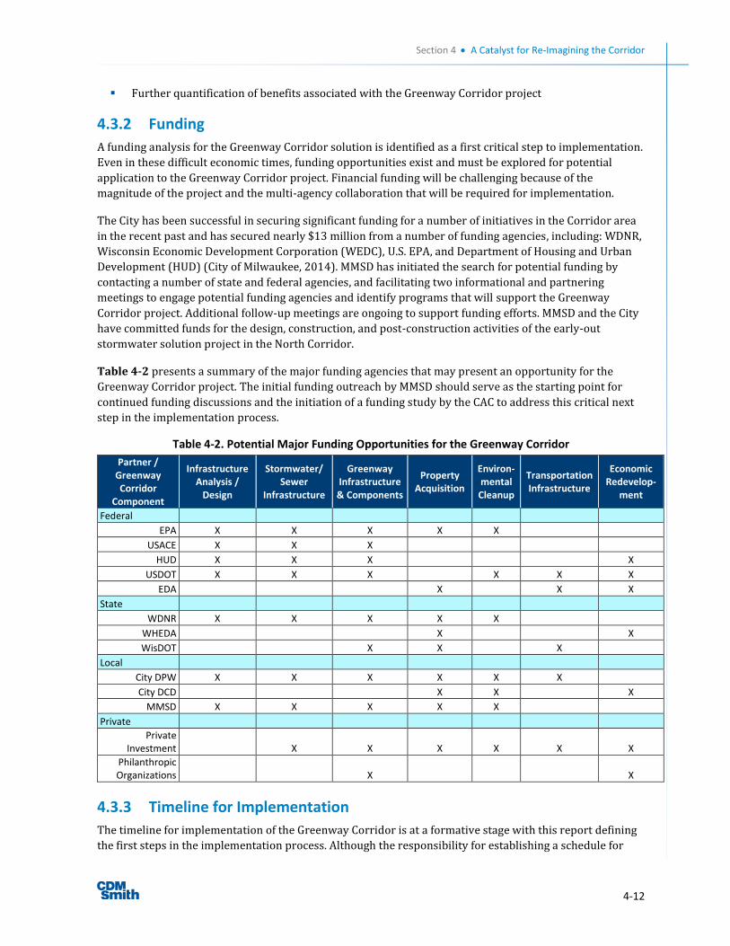
Section 4 A Catalyst for Re-Imagining the Corridor
4-12
Further quantification of benefits associated with the Greenway Corridor project
4.3.2 Funding
A funding analysis for the Greenway Corridor solution is identified as a first critical step to implementation.
Even in these difficult economic times, funding opportunities exist and must be explored for potential
application to the Greenway Corridor project. Financial funding will be challenging because of the
magnitude of the project and the multi-agency collaboration that will be required for implementation.
The City has been successful in securing significant funding for a number of initiatives in the Corridor area
in the recent past and has secured nearly $13 million from a number of funding agencies, including: WDNR,
Wisconsin Economic Development Corporation (WEDC), U.S. EPA, and Department of Housing and Urban
Development (HUD) (City of Milwaukee, 2014). MMSD has initiated the search for potential funding by
contacting a number of state and federal agencies, and facilitating two informational and partnering
meetings to engage potential funding agencies and identify programs that will support the Greenway
Corridor project. Additional follow-up meetings are ongoing to support funding efforts. MMSD and the City
have committed funds for the design, construction, and post-construction activities of the early-out
stormwater solution project in the North Corridor.
Table 4-2 presents a summary of the major funding agencies that may present an opportunity for the
Greenway Corridor project. The initial funding outreach by MMSD should serve as the starting point for
continued funding discussions and the initiation of a funding study by the CAC to address this critical next
step in the implementation process.
Table 4-2. Potential Major Funding Opportunities for the Greenway Corridor
Partner / Greenway Corridor
Component
Infrastructure Analysis /
Design
Stormwater/ Sewer
Infrastructure
Greenway Infrastructure
& Components
Property Acquisition
Environ-mental
Cleanup
Transportation Infrastructure
Economic Redevelop-
ment
Federal
EPA X X X X X
USACE X X X
HUD X X X X
USDOT X X X X X X
EDA X X X
State
WDNR X X X X X
WHEDA X X
WisDOT X X X
Local
City DPW X X X X X X
City DCD X X X
MMSD X X X X X
Private
Private Investment X X X X X X
Philanthropic Organizations X X
4.3.3 Timeline for Implementation
The timeline for implementation of the Greenway Corridor is at a formative stage with this report defining
the first steps in the implementation process. Although the responsibility for establishing a schedule for
Section 4 A Catalyst for Re-Imagining the Corridor
4-13
implementation rests with the CAC, an initial timeline is presented here to begin this process and to
identify several critical steps that must be taken as soon as practicable.
4.3.4 Funding, the First of Several Critical Initial Steps
The importance of securing an appropriate level of funding is the fundamental first step in defining an
implementation timeline, but several additional activities should be initiated as soon as sufficient funding is
available. As CAC moves forward with implementation, the following tasks or activities should be initiated
within the first six months of implementation:
CAC Action Plan
Community outreach
Greenway Corridor Neighborhood Plan
Economic analysis
Required land preservation
Funding plan
Environmental review
Workforce development strategy
Each of these activities is critical in terms of moving the overall Greenway Corridor project forward into the
next phase of design and property acquisition. Table 4-3 presents a timeline of these activities in the first
phase of implementation of the Greenway Corridor. The proposed timeline is aggressive and assumes that
funding will be secured in the first year of implementation. Assuming a best-case scenario that funding is
successful and secured early, and that environmental issues are effectively resolved, it may be possible to
begin Greenway Corridor design with route finalization and property identification in late 2016. The timing
for completion of design and property acquisition will be determined based on the final timeline developed
for construction based on the available funding. These initial actions will lay the groundwork for systematic
implementation of the Greenway Corridor solution for the entire Corridor area.
4.3.5 Greenway Corridor Early-out Projects
Several early-out projects have been identified in the North Corridor area and have preliminary approval
and funding in place. Design for the North Corridor stormwater solution is scheduled for completion in
2015 as the first early-out project with construction in 2016. Additional early-out projects may be
identified as planning proceeds. These early-out projects will be significant first steps to reduce flood
damages and will lay the groundwork for systematic implementation of the Greenway Corridor solution for
the entire Corridor area.

Section 4 A Catalyst for Re-Imagining the Corridor
4-14
Table 4-3. Greenway Corridor Timeline
2015 2016
1st 2nd 3rd 4th 1st 2nd 3rd 4th
Corridor Advisory Council Action Plan
Community Outreach
Greenway Corridor Neighborhood
Plan
Preliminary Engineering
Design (TBD)
Economic Analysis
Required Land Preservation
Funding Plan
Parcel Acquisition Plan
Property Acquisition (TBD)
Environmental Review
Environmental Assessment
O&M Responsibility
Early-out Project Implementation
Workforce Development Strategy
Greenway Corridor Construction
(TBD)
4.3.6 Corridor Workforce Strategy Collaboration and Specific Opportunities
MMSD and MAWIB collaborate to define long-term and individual project strategies to achieve local
workforce development goals through specific requirements in individual project bid documents. These
strategies specify minimum requirements for local work force involvement and enhancement through
individual construction projects throughout its service area.
MAWIB and MMSD are currently working together to develop a Workforce Development Strategy for the
initial North Corridor construction projects to maximize the opportunity for job creation and worker skill
acquisition. The strategy will identify the opportunities for work force development and job creation. Some
initial requirements include:
A certain percentage of the work hours be provided by “Fresh Coast” workers. Although the
percentage will vary depending on the specific project, selected projects could have a percentage as
high as 50-60 percent
Fresh Coast workers will be defined by a set of zip codes that include and surround the Corridor
Utilizing prevailing wage rates and setting a wage floor on projects without prevailing wage
requirements
Maximize apprentice utilization through journey-worker to apprentice ratios
Assistance by WRTP/BIG STEP in identifying the Fresh Coast workers
Section 4 A Catalyst for Re-Imagining the Corridor
4-15
The District and MAWIB will define a strategy for each project, identifying the specific requirements
appropriate for each project and will include them in the contract documents for bidding, ensuring that
they are implemented with award of each construction project.
MAWIB is also working with the Department of City Development to collaborate more closely in the long
term on future opportunities associated with its redevelopment initiatives such as Century City I and II to
better prepare the workforce to meet these needs. MAWIB anticipates that its efforts will be further
enhanced by the “Prosperity Plan” being prepared by DCD which will define a vision and supporting
principles to put the City and its residents on the path to economic success. The Prosperity Plan will focus
on location based opportunities, human capital development, entrepreneurship and innovation, and quality
of life and place. Specifically, the Prosperity Plan is anticipated to build on the Mayor’s Manufacturing
Partnership to develop a Center for Advanced Manufacturing at Century City, helping to align the local
workforce with these local industry growth opportunities.
5-1
Section 5 References
NWS (National Weather Service) Weather Forecast Office webpage: Flash Flooding/Heavy Rain Event &
Tornado Outbreak: July 22, 2010. http://www.crh.noaa.gov/mkx/?n=072210_severe
CBSNEWS webpage: Issue brief: Housing, Jake Miller, October 1, 2012.
http://www.cbsnews.com/news/issue-brief-housing/
Federal Bureau of Investigation Crime Statistics webpage: FBI Releases 2012 Crime Statistics, FBI National
Press Office, Washington, D.C., September 16, 2013. http://www.fbi.gov/news/pressrel/press-releases/fbi-
releases-2012-crime-statistics
The Policymap Blog webpage: Data Loading and Geocoding: Part II, by Bernie Langer.
http://www.policymap.com/blog/
United States Census 2010 webpage: Interactive Population Map.
http://www.census.gov/2010census/popmap/
Daily Kos website: Milwaukee – A Third World City, by Will Smith, June 29, 2013.
http://www.dailykos.com/story/2013/06/30/1220042/-Milwaukee-A-Third-World-City#
Milwaukee Journal Sentinel website: Metropolitan Milwaukee Gets Poor Marks in Air Quality, Lee Bergquist,
April 24, 2013. http://www.jsonline.com/news/milwaukee/metropolitan-milwaukee-gets-poor-marks-in-
air-quality-5t9mrf6-204576051.html
MMSD website: Sewer Sustainable Water Reclamation, MMSD, February 2012. http://www.mmsd.com/-
/media/MMSD/Documents/Sustainability/Sustainability%20Plan.pdf
Walkscore webpage: Walnut Hill Neighborhood Walkability Score and Description.
http://www.walkscore.com/score/walnutill-milwaukee-wi
Milwaukee Assessor’s Data webpage: City of Milwaukee, Map Milwaukee Portal, June 2013.
http://city.milwaukee.gov/mapmilwaukee
New York Times webpage: Gardening Books, Dominique Browning, June 2, 2011.
http://www.nytimes.com/2011/06/05/books/review/book-review-summer-gardening-
roundup.html?pagewanted=1&_r=3&sq=dominique%20browning&st=cse&scp=3&
U.S. Department of the Interior National Park Service webpage: Economic Impacts of Protecting Rivers,
Trails, and Greenway Corridors: A Resource Book, 1995, Fourth Addition Revised.
http://www.nps.gov/pwro/rtca/econ_all.pdf
The Trust for Public Land webpage: Measuring the Economic Value of a City Park System, Harnik and Welle,
2009. http://cloud.tpl.org/pubs/ccpe-econvalueparks-rpt.pdf
Rails to Trails webpage: Economic Benefits of Trails and Greenways, 1998. http://www.railstotrails.org/resources/documents/resource_docs/tgc_economic.pdf
Section 5 References
5-2
University of Washington Staff Server webpage: Journal of Park and Recreation Administration, Property Values, Recreation Values, and Urban Greenways, Volume 22, Numbe6r 93, Lindsey et al, Fall 2004. http://staff.washington.edu/kwolf/Archive/Classes/ESRM304_SocSci/304%20Soc%20Sci%20Lab%20Articles/Lindsey_2004.pdf
Texas A&M Agrilife webpage: National Recreation and Park Association, The Impact of Greenways on
Property Values: Evidence from Austin, Texas, Journal of Leisure Research, 2005, Vol. 37, No.3, pp. 321-341.
http://agrilife.org/cromptonrpts/files/2011/06/4_2_7.pdf
University of Wisconsin-Milwaukee Center for Economic Development webpage: Impact of Green
Infrastructure on Property Values within the MMSD Planning Area: Case Studies, Catherine Madison, AICP
and John Kovari, PhD, May 2013.
http://www4.uwm.edu/ced/publications/MMSD_GreenInfrastructure_Final.pdf
American Trails webpage: Evidence of Many Varieties of Economic Benefits Linked to Trails, Stuart
Macdonald, Summer 2011. http://www.americantrails.org/resources/economics/economic-benefits-
trails-macdonald.html
Menomonee Valley Partners, Inc. webpage: Menomonee Valley from the Ground Up, 2013.
http://renewthevalley.org/media/mediafile_attachments/03/233-
finalmenomoneevalleyfromthegroundupexecutivesummary.pdf
Urban Ecology Center (2014) http://urbanecologycenter.org/
City of Milwaukee Department of City Development webpage: Welcome to the 30th Street Industrial Corridor:
http://city.milwaukee.gov/Projects/30thStreetIndustrialCorridor.htm
DCD: E-mail coordination between Karen Taylor (DCD) and Scott Gussick (WHEDA) on January 30th, 2014.
City of Milwaukee, Department of City Development, personal email from Kein Burton, February 5, 2014.
Milwaukee Area Workforce Investment Board (MAWIB) webpage, November 30, 2014.
http://milwaukeewib.org/
Wisconsin Regional Training Partnership (WRTP) webpage, November 30, 2014. http://www.wrtp.org/
UW Extension Center for Community and Economic Development, “Estimated Economic Impacts of
Construction for the 30th Street Corridor Stormwater Project (South Section),” received via WHEDA email
transmission, April 14, 2014