Embed Size (px)
Citation preview
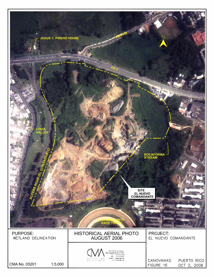
El Nuevo Comandante
Wetland Delineation
October 2006
Page 26
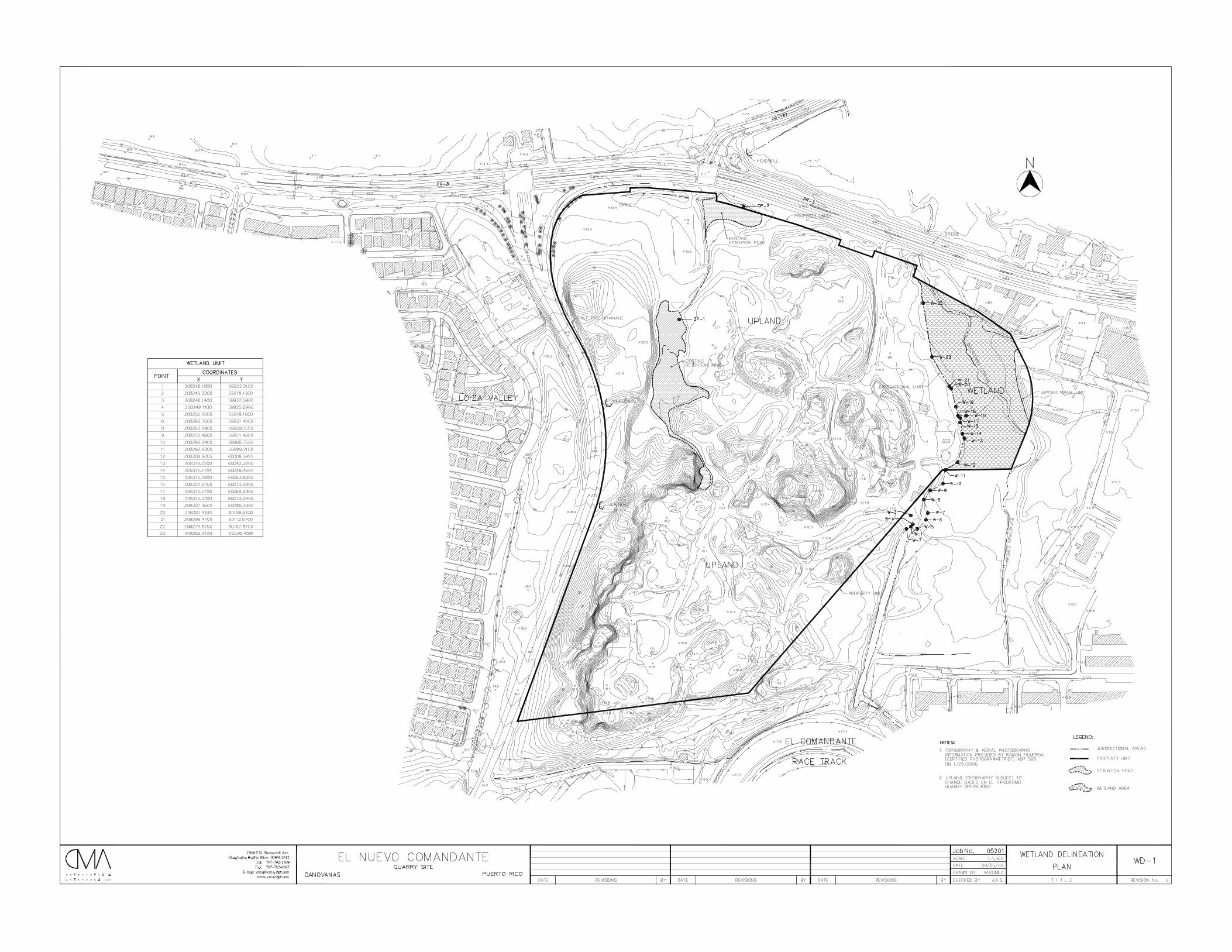
3.0 CONCLUSIONS AND RECOMMENDATIONS
The vegetation, soil and hydrology obtained from the published data and
during the site visits to the studied area meet the three wetland criteria required by
the U.S. Corps of Engineers (USCOE) to declare an area as a wetland in those areas
delineated as wetlands. The areas delineated as uplands do not meet the three-
wetland criteria. The wetland area was delineated by the lower elevation. This
wetland area comprises 5.5 acres approximately. The surrounding upland areas are
higher and well defined on the eastern and southern part by the unvegetated area.
The boring locations and wetland boundaries were located using a
photogrammetry survey prepared by surveyor Ramón Figueroa. Enclosed please find
the Wetland Delineation Plan W-1.

DATA FORM
ROUTINE WETLAND DETERMINATION
(1987 COE Wetlands Delineation Manual)
Project/Site: El Nuevo Comandante Date: April 20, 2006 Applicant/Owner: Land Development Associates County: Canóvanas Investigator: CMA Architects & Engineers LLP State: PR Do Normal Circumstances exist on the site? Yes No Community ID: Is the site significantly disturbed (Atypical Situation)? Yes No Transect ID: Is the area a potential Problem Area? Yes No Plot ID: OP-1 (If needed, explain on reverse.)
VEGETATION
Dominant Plant Species
Stratum Indicator Dominant Plant Species Stratum Indicator
1.
Sesbania sericea HERB FACW 9.
2.
Urochloa maxima HERB UPL 10.
3.
Paspalum fasciculatum HERB FACW 11.
4.
12.
5.
13.
6.
14.
7.
15.
8.
16.
Percent of Dominant Species that are OBL, FACW or FAC
(excluding FAC-). 100
Remarks: The observation point was located on toe of slope of the detention pond or settling basin.This pond was created by excavating from dry land and used exclusively as a settling basins, or detention pond.
HYDROLOGY
Recorded Data (Describe in Remarks): Wetland Hydrology Indicators:
Stream, Lake, or Tide Gauge Primary Indicators:
Aerial Photographs Inundated
Other Saturated in Upper 12 Inches
No Recorded Data Available Water Marks
Drift Lines
Sediment Deposits
Field Observations: Drainage Patterns in Wetlands
Secondary Indicators (2 or more required):
Depth of Surface Water: 0 (in.) Oxidized Root Channels in Upper 12 Inches
Water-Stained Leaves
Depth to Free Water in Pit: (in.) Local Soil Survey Data
FAC-Neutral Test
Depth to Saturated Soil: 0 (in.) Other (Explain in Remarks)
Remarks:
SOILS
Map Unit Name
(Series and Phase): Caguabo Series (CbF2) Caguabo Clay Loam Drainage Class: Well drained
Field Observations
Taxonomy (Subgroup): Lithic Eutrudepts Confirm Mapped Type? Yes No
Profile Descriptions: Depth Matrix Color Mottle Colors Mottle Abundance/ Texture, Concretions,
(inches) Horizon (Munsell Moist) (Munsell Moist) Size/Contrast Structure, etc,
0-2 10YR 4/3 sandy
2-10 3/10Y & 4/N distinct sandy
10 - rock, hard
Hydric Soil Indicators:
Histosol Concretions
Histic Epipedon High Organic Content in Surface Layer in Sandy Soils
Sulfidic Odor Organic Streaking in Sandy Soils
Aquic Moisture Regime Listed on Local Hydric Soils List
Reducing Conditions Listed on National Hydric Soils List
Gleyed or Low-Chroma Colors Other (Explain in Remarks)
Remarks: This pond was created by excavating from dry land and used exclusively as a settling basins, or detention pond. the hydric soils indicators were observed due to the function of the pond.
WETLAND DETERMINATION
Hydrophytic Vegetation Present? Yes No (Check) (Check)
Wetland Hydrology Present? Yes No
Hydric Soils Present? Yes No Is this Sampling Point Within a Wetland? Yes No
RemarksThis pond was created by excavating from dry land and used exclusively as a settling basins, or detention pond.The upland area do not show hydric soils. The hydrology comes primarily from stormwater runoff during rain events.
Approved by HQUSACE 3/92
Forms version 1/02
DATA FORM
ROUTINE WETLAND DETERMINATION
(1987 COE Wetlands Delineation Manual)
Project/Site: El Nuevo Comandante Date: September 21, 2006 Applicant/Owner: Land Development Associates County: Canóvanas Investigator: CMA Architects & Engineers LLP State: PR Do Normal Circumstances exist on the site? Yes No Community ID: Is the site significantly disturbed (Atypical Situation)? Yes No Transect ID: Is the area a potential Problem Area? Yes No Plot ID: OP-2 (If needed, explain on reverse.)
VEGETATION
Dominant Plant Species
Stratum Indicator Dominant Plant Species Stratum Indicator
1.
Brachiaria purpurascens HERB FACW 9.
2.
Urochloa maxima HERB UPL 10.
3.
Paspalum fasciculatum HERB FACW 11.
4.
12.
5.
13.
6.
14.
7.
15.
8.
16.
Percent of Dominant Species that are OBL, FACW or FAC
(excluding FAC-). 100
Remarks: The B. purpurascens covers the area. The information of this observation point is located at the bottom of the detention pond.
HYDROLOGY
Recorded Data (Describe in Remarks): Wetland Hydrology Indicators:
Stream, Lake, or Tide Gauge Primary Indicators:
Aerial Photographs Inundated
Other Saturated in Upper 12 Inches
No Recorded Data Available Water Marks
Drift Lines
Sediment Deposits
Field Observations: Drainage Patterns in Wetlands
Secondary Indicators (2 or more required):
Depth of Surface Water: 0 (in.) Oxidized Root Channels in Upper 12 Inches
Water-Stained Leaves
Depth to Free Water in Pit: (in.) Local Soil Survey Data
FAC-Neutral Test
Depth to Saturated Soil: 0 (in.) Other (Explain in Remarks)
Remarks:
The information of this observation point is located at the bottom of the detention pond.
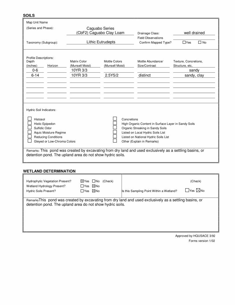
SOILS
Map Unit Name
(Series and Phase): Caguabo Series (CbF2) Caguabo Clay Loam Drainage Class: well drained
Field Observations
Taxonomy (Subgroup): Lithic Eutrudepts Confirm Mapped Type? Yes No
Profile Descriptions: Depth Matrix Color Mottle Colors Mottle Abundance/ Texture, Concretions,
(inches) Horizon (Munsell Moist) (Munsell Moist) Size/Contrast Structure, etc,
0-6 10YR 3/3 sandy
6-14 10YR 3/3 2.5Y5/2 distinct sandy, clay
Hydric Soil Indicators:
Histosol Concretions
Histic Epipedon High Organic Content in Surface Layer in Sandy Soils
Sulfidic Odor Organic Streaking in Sandy Soils
Aquic Moisture Regime Listed on Local Hydric Soils List
Reducing Conditions Listed on National Hydric Soils List
Gleyed or Low-Chroma Colors Other (Explain in Remarks)
Remarks: This pond was created by excavating from dry land and used exclusively as a settling basins, or detention pond. The upland area do not show hydric soils.
WETLAND DETERMINATION
Hydrophytic Vegetation Present? Yes No (Check) (Check)
Wetland Hydrology Present? Yes No
Hydric Soils Present? Yes No Is this Sampling Point Within a Wetland? Yes No
RemarksThis pond was created by excavating from dry land and used exclusively as a settling basins, or detention pond. The upland area do not show hydric soils.
Approved by HQUSACE 3/92
Forms version 1/02
DATA FORM
ROUTINE WETLAND DETERMINATION
(1987 COE Wetlands Delineation Manual)
Project/Site: El Nuevo Comandante Date: April 12, 2006 Applicant/Owner: Land Development Associates County: Canóvanas Investigator: CMA Architects & Engineers LLP State: PR Do Normal Circumstances exist on the site? Yes No Community ID: Is the site significantly disturbed (Atypical Situation)? Yes No Transect ID: Is the area a potential Problem Area? Yes No Plot ID: W-1@ 13 (If needed, explain on reverse.)
VEGETATION
Dominant Plant Species
Stratum Indicator Dominant Plant Species Stratum Indicator
1.
Brachiaria purpurascens HERB FACW 9.
2.
10.
3.
11.
4.
12.
5.
13.
6.
14.
7.
15.
8.
16.
Percent of Dominant Species that are OBL, FACW or FAC
(excluding FAC-). 100
Remarks: The wetland limit was located on toe of slope. The B. purpurascens covers wetland and upland areas. The information of this observation point is located approximately 1 - 2 meters from the limit.
HYDROLOGY
Recorded Data (Describe in Remarks): Wetland Hydrology Indicators:
Stream, Lake, or Tide Gauge Primary Indicators:
Aerial Photographs Inundated
Other Saturated in Upper 12 Inches
No Recorded Data Available Water Marks
Drift Lines
Sediment Deposits
Field Observations: Drainage Patterns in Wetlands
Secondary Indicators (2 or more required):
Depth of Surface Water: 0 (in.) Oxidized Root Channels in Upper 12 Inches
Water-Stained Leaves
Depth to Free Water in Pit: (in.) Local Soil Survey Data
FAC-Neutral Test
Depth to Saturated Soil: 0 (in.) Other (Explain in Remarks)
Remarks:
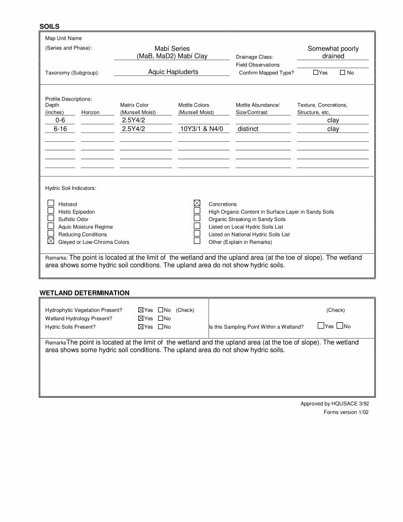
SOILS
Map Unit Name
(Series and Phase): Mabí Series (MaB, MaD2) Mabí Clay Drainage Class:
Somewhat poorly drained
Field Observations
Taxonomy (Subgroup): Aquic Hapluderts Confirm Mapped Type? Yes No
Profile Descriptions: Depth Matrix Color Mottle Colors Mottle Abundance/ Texture, Concretions,
(inches) Horizon (Munsell Moist) (Munsell Moist) Size/Contrast Structure, etc,
0-6 2.5Y4/2 clay
6-16 2.5Y4/2 10Y3/1 & N4/0 distinct clay
Hydric Soil Indicators:
Histosol Concretions
Histic Epipedon High Organic Content in Surface Layer in Sandy Soils
Sulfidic Odor Organic Streaking in Sandy Soils
Aquic Moisture Regime Listed on Local Hydric Soils List
Reducing Conditions Listed on National Hydric Soils List
Gleyed or Low-Chroma Colors Other (Explain in Remarks)
Remarks: The point is located at the limit of the wetland and the upland area (at the toe of slope). The wetland area shows some hydric soil conditions. The upland area do not show hydric soils.
WETLAND DETERMINATION
Hydrophytic Vegetation Present? Yes No (Check) (Check)
Wetland Hydrology Present? Yes No
Hydric Soils Present? Yes No Is this Sampling Point Within a Wetland? Yes No
RemarksThe point is located at the limit of the wetland and the upland area (at the toe of slope). The wetland area shows some hydric soil conditions. The upland area do not show hydric soils.
Approved by HQUSACE 3/92
Forms version 1/02

DATA FORM
ROUTINE WETLAND DETERMINATION
(1987 COE Wetlands Delineation Manual)
Project/Site: El Nuevo Comandante Date: April 20, 2006 Applicant/Owner: Land Development Associates County: Canóvanas Investigator: CMA Architects & Engineers LLP State: PR Do Normal Circumstances exist on the site? Yes No Community ID: Is the site significantly disturbed (Atypical Situation)? Yes No Transect ID: Is the area a potential Problem Area? Yes No Plot ID: W-14 @ 22 (If needed, explain on reverse.)
VEGETATION
Dominant Plant Species
Stratum Indicator Dominant Plant Species Stratum Indicator
1.
Brachiaria purpurascens HERB FACW 9.
2.
Mimosa casta HERB FACW 10.
3.
Ipomoea tiliacea HERB FACW 11.
4.
12.
5.
13.
6.
14.
7.
15.
8.
16.
Percent of Dominant Species that are OBL, FACW or FAC
(excluding FAC-). 100
Remarks: The wetland limit was located on toe of slope. The B. purpurascens covers wetland and upland areas. The information of this observation point is located approximately 1 - 2 meters from the limit.
HYDROLOGY
Recorded Data (Describe in Remarks): Wetland Hydrology Indicators:
Stream, Lake, or Tide Gauge Primary Indicators:
Aerial Photographs Inundated
Other Saturated in Upper 12 Inches
No Recorded Data Available Water Marks
Drift Lines
Sediment Deposits
Field Observations: Drainage Patterns in Wetlands
Secondary Indicators (2 or more required):
Depth of Surface Water: 0 (in.) Oxidized Root Channels in Upper 12 Inches
Water-Stained Leaves
Depth to Free Water in Pit: (in.) Local Soil Survey Data
FAC-Neutral Test
Depth to Saturated Soil: 0 (in.) Other (Explain in Remarks)
Remarks:
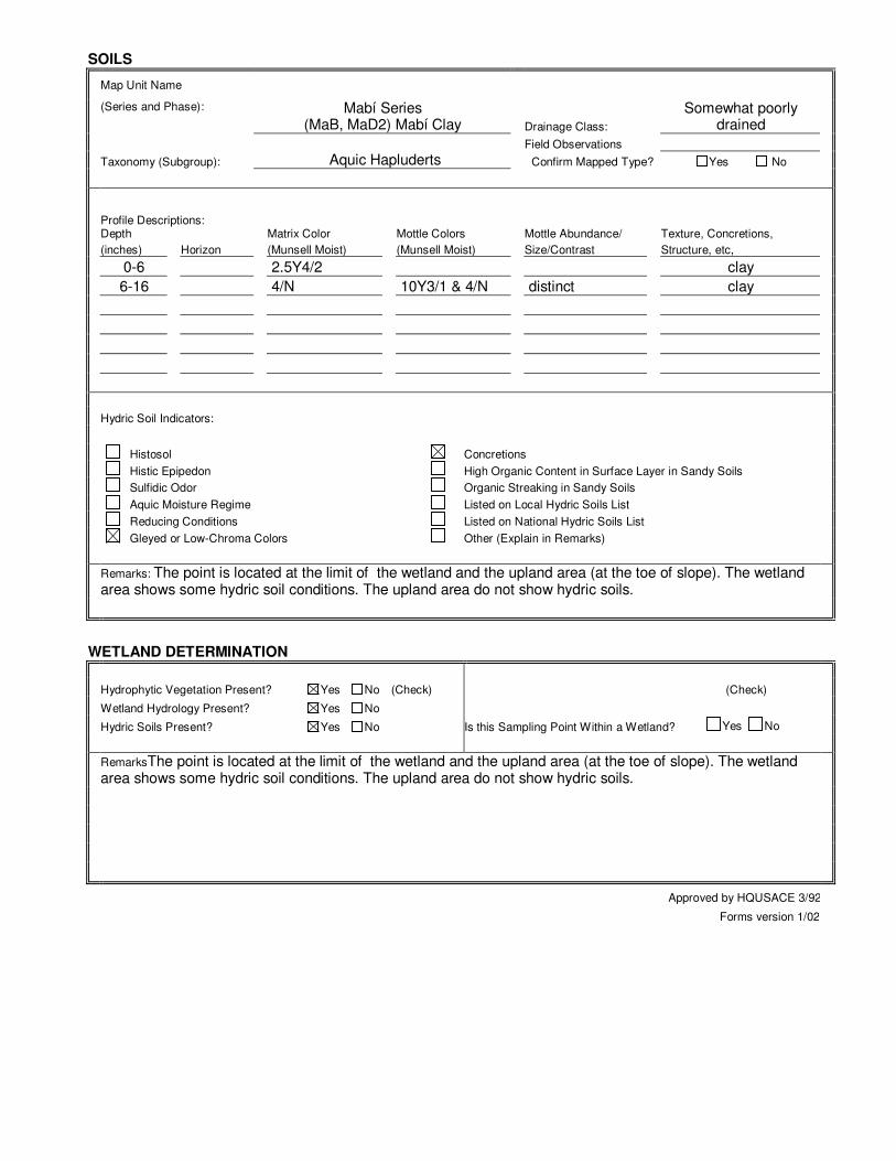
SOILS
Map Unit Name
(Series and Phase): Mabí Series (MaB, MaD2) Mabí Clay Drainage Class:
Somewhat poorly drained
Field Observations
Taxonomy (Subgroup): Aquic Hapluderts Confirm Mapped Type? Yes No
Profile Descriptions: Depth Matrix Color Mottle Colors Mottle Abundance/ Texture, Concretions,
(inches) Horizon (Munsell Moist) (Munsell Moist) Size/Contrast Structure, etc,
0-6 2.5Y4/2 clay
6-16 4/N 10Y3/1 & 4/N distinct clay
Hydric Soil Indicators:
Histosol Concretions
Histic Epipedon High Organic Content in Surface Layer in Sandy Soils
Sulfidic Odor Organic Streaking in Sandy Soils
Aquic Moisture Regime Listed on Local Hydric Soils List
Reducing Conditions Listed on National Hydric Soils List
Gleyed or Low-Chroma Colors Other (Explain in Remarks)
Remarks: The point is located at the limit of the wetland and the upland area (at the toe of slope). The wetland area shows some hydric soil conditions. The upland area do not show hydric soils.
WETLAND DETERMINATION
Hydrophytic Vegetation Present? Yes No (Check) (Check)
Wetland Hydrology Present? Yes No
Hydric Soils Present? Yes No Is this Sampling Point Within a Wetland? Yes No
RemarksThe point is located at the limit of the wetland and the upland area (at the toe of slope). The wetland area shows some hydric soil conditions. The upland area do not show hydric soils.
Approved by HQUSACE 3/92
Forms version 1/02
DATA FORM
ROUTINE WETLAND DETERMINATION
(1987 COE Wetlands Delineation Manual)
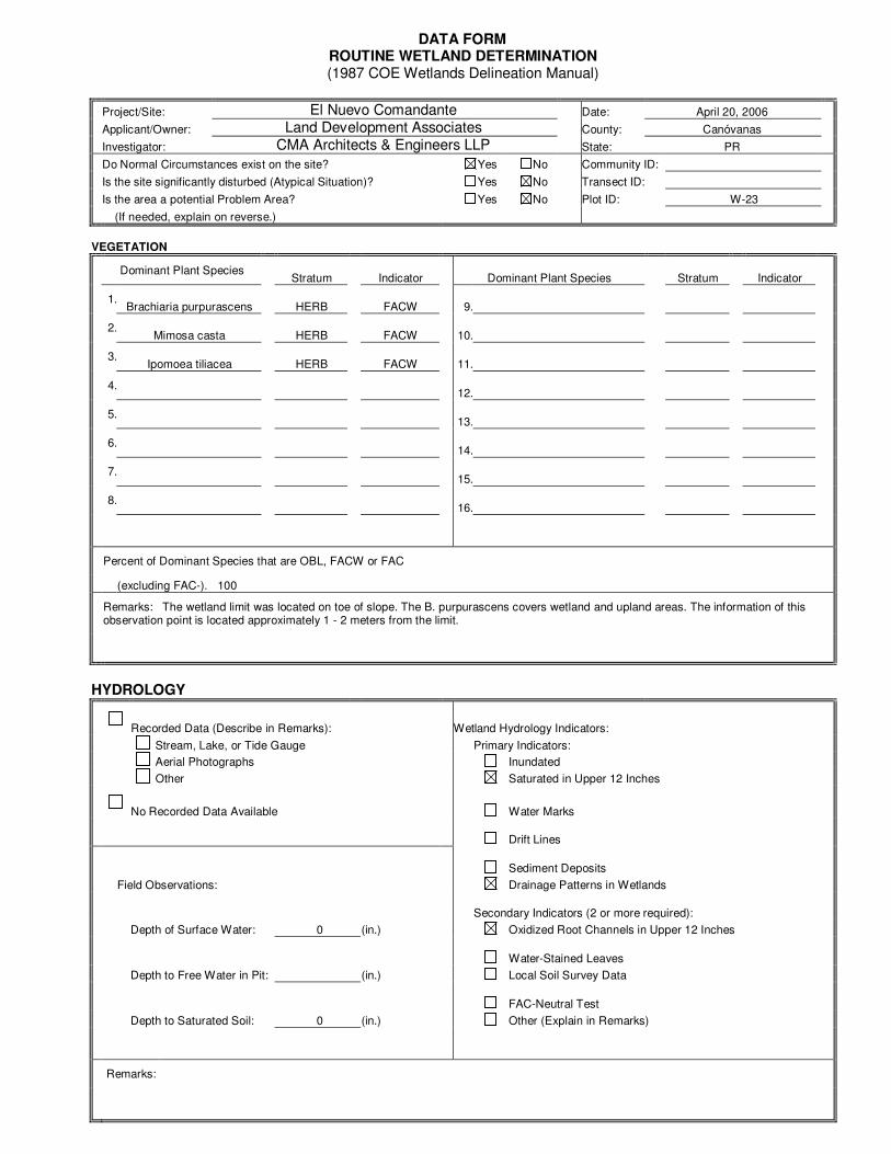
Project/Site: El Nuevo Comandante Date: April 20, 2006 Applicant/Owner: Land Development Associates County: Canóvanas Investigator: CMA Architects & Engineers LLP State: PR Do Normal Circumstances exist on the site? Yes No Community ID: Is the site significantly disturbed (Atypical Situation)? Yes No Transect ID: Is the area a potential Problem Area? Yes No Plot ID: W-23 (If needed, explain on reverse.)
VEGETATION
Dominant Plant Species
Stratum Indicator Dominant Plant Species Stratum Indicator
1.
Brachiaria purpurascens HERB FACW 9.
2.
Mimosa casta HERB FACW 10.
3.
Ipomoea tiliacea HERB FACW 11.
4.
12.
5.
13.
6.
14.
7.
15.
8.
16.
Percent of Dominant Species that are OBL, FACW or FAC
(excluding FAC-). 100
Remarks: The wetland limit was located on toe of slope. The B. purpurascens covers wetland and upland areas. The information of this observation point is located approximately 1 - 2 meters from the limit.
HYDROLOGY
Recorded Data (Describe in Remarks): Wetland Hydrology Indicators:
Stream, Lake, or Tide Gauge Primary Indicators:
Aerial Photographs Inundated
Other Saturated in Upper 12 Inches
No Recorded Data Available Water Marks
Drift Lines
Sediment Deposits
Field Observations: Drainage Patterns in Wetlands
Secondary Indicators (2 or more required):
Depth of Surface Water: 0 (in.) Oxidized Root Channels in Upper 12 Inches
Water-Stained Leaves
Depth to Free Water in Pit: (in.) Local Soil Survey Data
FAC-Neutral Test
Depth to Saturated Soil: 0 (in.) Other (Explain in Remarks)
Remarks:
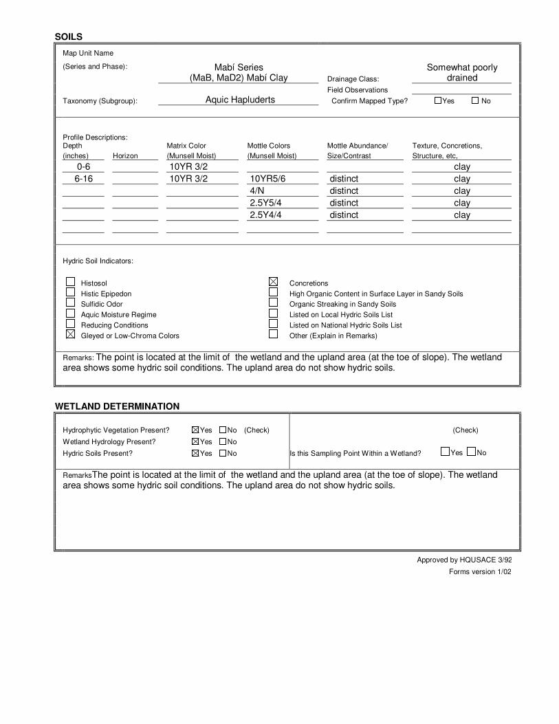
SOILS
Map Unit Name
(Series and Phase): Mabí Series (MaB, MaD2) Mabí Clay Drainage Class:
Somewhat poorly drained
Field Observations
Taxonomy (Subgroup): Aquic Hapluderts Confirm Mapped Type? Yes No
Profile Descriptions: Depth Matrix Color Mottle Colors Mottle Abundance/ Texture, Concretions,
(inches) Horizon (Munsell Moist) (Munsell Moist) Size/Contrast Structure, etc,
0-6 10YR 3/2 clay
6-16 10YR 3/2 10YR5/6 distinct clay
4/N distinct clay
2.5Y5/4 distinct clay
2.5Y4/4 distinct clay
Hydric Soil Indicators:
Histosol Concretions
Histic Epipedon High Organic Content in Surface Layer in Sandy Soils
Sulfidic Odor Organic Streaking in Sandy Soils
Aquic Moisture Regime Listed on Local Hydric Soils List
Reducing Conditions Listed on National Hydric Soils List
Gleyed or Low-Chroma Colors Other (Explain in Remarks)
Remarks: The point is located at the limit of the wetland and the upland area (at the toe of slope). The wetland area shows some hydric soil conditions. The upland area do not show hydric soils.
WETLAND DETERMINATION
Hydrophytic Vegetation Present? Yes No (Check) (Check)
Wetland Hydrology Present? Yes No
Hydric Soils Present? Yes No Is this Sampling Point Within a Wetland? Yes No
RemarksThe point is located at the limit of the wetland and the upland area (at the toe of slope). The wetland area shows some hydric soil conditions. The upland area do not show hydric soils.
Approved by HQUSACE 3/92
Forms version 1/02
El Nuevo Comandante
Wetland Delineation
October 2006
Page 28
4.0 BIBLIOGRAPHY
Acevedo-Rodríguez. 1996. Flora of St. John, U.S. Virgin Islands. Memoirs of the New
York Botanical Garden. Brown, S. Lugo, A. A Comparison of Structural and Functional Characteristics of
Saltwater and Freshwater Forested Wetlands.
Chinn, Richard. 2001. Wetland Delineation & Management Training Manual and Workbook. Richard Chinn Environmental Training, Inc.
Dansereau, Pierre. 1966. Studies on the Vegetation of Puerto Rico: Description and
Integration of the Plant-Communities. University of Puerto Rico.
Dennison M.S.; Berry J.F. 1993.Wetlands, Guide to Science, Law and Technology. Noyes
Publications.
Ewel, J. S. Whitmore, J. L. 1973. Ecological Life Zones of Puerto Rico and the Virgin
Islands. USDA Forest Service Research Paper ITF - 18. pp.
Lugo A. 1989. Forested Wetlands. Ecosystems of the World. Elsevier Pub. Co. 527 pp. Little, E.L., Wadsworth, F.H.. 1974. Common Trees of Puerto Rico and the Virgin Islands.
Vol. II. USDA Forest Service Agricultural Handbook No. 449.
Little, E.L., Wadsworth, F.H. 1995. Common Trees of Puerto Rico and the Virgin Islands.
Vol. I. USDA Forest Service Agricultural Handbook No. 249. 4th Printing. Lugo, A., S. Brown and M. Brinson. 1988. Forested wetlands in freshwater and salt-
water environments. Limnol. Oceanogr. 33 (4, part 2). 894-909. Lyon, J.G. 1993. Practical Handbook for Wetland Identification and Delineation.
Lewis Publishers. pp. 34.
Mark, P. Ashton, S. 1989. Foresters Field Guide to the Trees and Shrubs of Puerto Rico. 2nd Edition.
Mitsch, William. James Gosselink. 1986. Wetlands. Van Nostrand Reinhold.
El Nuevo Comandante
Wetland Delineation
October 2006
Page 29
Puerto Rico Department of Natural and Environmental Resources. 1989. Critical Wildlife Areas of Puerto Rico.
University of Puerto Rico Mayagüez Campus. Guía Ilustrada de Yerbas Comunes en
Puerto Rico.
US Army Corps of Engineers. Preliminary Guide to Wetlands of Puerto Rico. Technical
Report Y-87-3. 1978. ---. 1987 Corps of Engineers Wetlands Delineation Manual. Technical Report Y-87-1.
---. 1988. A Guide to Selected Florida Wetland Plants and Communities. USDA Soil Conservation Service. 1977. Soil Survey of Humacao Area of Eastern Puerto
Rico.
---. 2001. National Technical Committee for Hydric Soils. Hydric Soils of the Caribbean
Area. USDA-NRCS, Wetland Science Institute and Soil Survey Division. Field Indicators of
Hydric Soils in the United States. Version 5.0. March 2002. US Fish and Wildlife Service. 1985. National Wetlands Inventory Map, Rincón
Quadrangle.
US Fish and Wildlife Service, National Wetlands Inventory Ecology Section. 995; National List of Plant Species that Occur in Wetlands, Caribbean Region (Region C).
Vélez, I. 1950. Plantas Indeseables en los Cultivos Tropicales. Editorial de la
Universidad de Puerto Rico, Río Piedras.