Embed Size (px)
Citation preview
Oshawa
Pickering to Port Hope3
www.waterfronttrail.org
Map
3-1
Car
te
Map
3-1
Car
te
401
22
Hwy
2
Hwy
2
1
38
Rick HullMemorial
Park
DunmoorePark
LookoutPointPark
Bruce HanscombePark
AlexRobertson
Park
AlexRobertson
Park
HomeplaceHomeplace
KinsmenPark
AlderwoodParkette
ParkhamParkette
CommerceSt Pk
Balsdon Park
DouglasPark
Mitchell Park
Petticoat CreekConservation Area
Ernie L.StroudPark
East Woodlands
Park
AmberleaPark
Beachfront Park
Information Centre
GlenRavine Pktte
Wind Turbine
Pickering Nuclear
Generating Station
Rouge
Marsh
Rouge River
Rosebank
RougeBeachPark
Creek
Petticoat
Frenchman’s
Bay
Highbush
Dunbarton
Brock
Industrial
Park
Bay
Ridges
West
Shore
Fairport
Pettico
at Creek
PickeringMarina
Swans Marina
Frenchmans BayYacht Club
PickeringRougeCanoe Club
P
MillenniumSquare
P
P
ProgressFrenchmans
Bay East Park P
PP
P
RotaryFrenchmans Bay West Park
P
P
P
Pickering
PickeringGO Station
P
P
RosebankSouthPark
Cyclists use sidewalkCyclistes, utilisez le trottoir
Exit 397Sortie 397
Sortie 399
$
$
$
$
$
Kingston
R
d
Whi
tes
Rd
Wes
t
Sho
re
B
lvd
Oklahoma Dr
Strouds
Liv
erp
oo
l
R
d
Bro
ck
R
d
San
dy
B
each
R
d
Bayly St
Bay
ly
St
Sheppard Av
Whites R
d
Bro
ck
R
d
Sheppard Av
Altona
Rd
Montgomery
Par
k
Cr
Rodd Av
Dyso
n Rd
Ros
eban
k
Rd
Lawren
ce A
v
Surf Av
Fro
nt R
d
Mc
McK
ay
Rd
Pa
rk Rd
Dill
ingh
am
Rd
Clements Rd
Pine Ridge Rd
Toynevale Rd
Oak
woo
d
Dr
Rougemount Dr D
yson Rd
Rougem
ount Dr
Roseb
ank Rd
Foxwood Tr
Granite Ct
Broadgreen
S
t
Mar
ksb
ury
Rd
Beachpoint
Promenade
Bre
ezy
Dr
Eyer
Dr
Hill
cres
t
Rd
Vis tula Dr
Ed
mund
Dr
Steeple Hill
Downland Dr
Sunrise Av
Mink St
Breezy Dr
Vistula D
r
Elvira Ct
Edgewood Rd
Shadybrook D
r
Commerce St
Annland St
Wharf St
Do
ug
las
Av
Fairv
iew
Av
Browning Av
St
Mar
tins
Dr
Sandbar Rd
Radom St
Dunbarton
Rd
Beg
ley
St
Tatra Dr
Krosno Blvd
Krosno B
lvdR
eytan Blvd
Ann
land
St
Live
rpoo
l
R
d
Rouge Hills Dr
BellaVista
Drestuge rk
To Hwy. 401Vers l’Aut. 401
L A K E / L A C
O N T A R I O
$
$
401
RougeNationalUrbanPark
Legend / Légende
2.0
Great Lakes Waterfront Trail /Sentier riverain
On-road / Sur la route
Off-road / Hors route
Connection / Liaison
Alerts / Alertes
Distance / Distance (km)
Other Connecting Trails /Autres sentiers de liaison
Park, Natural Area /Parc, Espace naturel
Cemetery / Cimetière
$
P
?Hospital / Hôpital
Beach / Plage
Campground / Camping
Attraction / Attraction
Marina / Marina
Parking / Stationnement
Lookout / Vue panoramique
Shopping / Zone commerciale
Town Hall / Hôtel de ville
Information / Renseignements
Washrooms / W.-C.
Index Map
PickeringSee Profile:
Map Displayed#3–1
1
2
3 4
5
5B6
7
© Lucidmap Inc. 2017
Frenchman’s Bay
2-16 3-2
N
Scale0 .25 .5 km
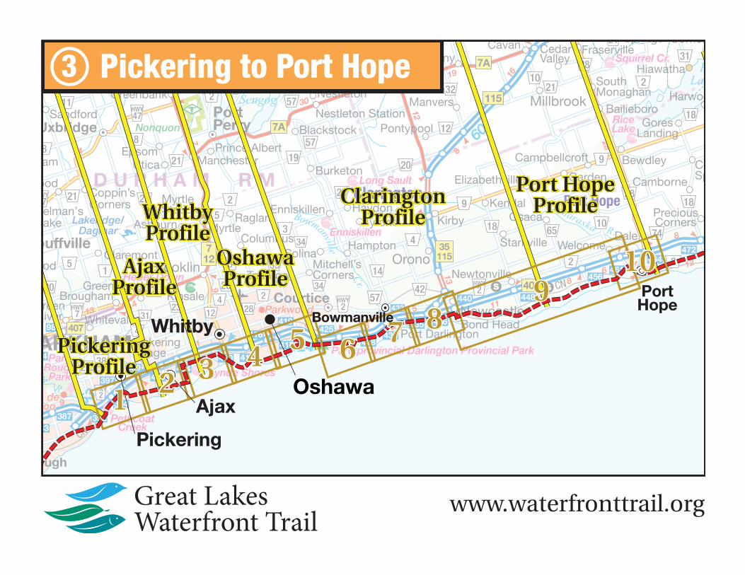
Map 1 Trail Length: 10.4 km Map 3-1 : Frenchman’s Bay
www.waterfronttrail.orgMap updated January, 2017
Map
3-2
Car
te
Map
3-2
Car
te
22
1
31
41
44
31
Annandale
Golf Course
and
Country ClubExeterPark
DuffinsPark
AjaxWaterfront
Park
Kinsmen Park
LordDurham
Park
ClementsWoodlot
Information Centre Paradise Park
LakesidePark
RotaryPark
Veterans PointGardens
Pickering Nuclear
Generating Station
PickeringBeach
Ca
rruth
ers
Cre
ek
Duffins
Creek
Car M
Clover Ridge
Discovery Bay
Duffins Bay
Southwood
Simcoe Point
PP
P
Lion’s Point
P
P
Rouge ValleyHealth System
Ajax
DurhamPublic
GardensP
J.A.Murray
Park
P
Paradise ParkBeach Area
Carruthers Marsh Pavilion
CarrMarsh
Duffins Trail / Trans C
anada Trail
PAjax
CommunityCentre
AjaxCommunity
Centre
Sho
al
Po
int
Tra
il
Sortie 399
Lake Vista
WoodhousePark
AjaxWaterfront
Park
Bridge crossing,cyclists dismountTraversée de pont,les cyclistes doiventdescendre.
$
$
$
$
$
$
$
Bro
ck
R
d
Bayly St
Bro
ck
R
d
Westney Rd S
Lake
D
rivew
ay
W
Lake Driveway W
Har
woo
d
Av
S
Lakeview Blvd
Sho
al
P
oint
R
d
Wes
tney
Rd
S
Chu
rch
S
t
S
Pic
keri
ng
Bea
ch
Rd
Sal
em
R
d
Bayly St W
Montgomery
Pop
lar
Av
Map
le
AvRange Line Rd
A
McKay Rd Jodrel RdM
cKay
R
d
Montgomery Park RdP
ark R
d
Fris
co
Rd
Clo
ver
Rid
ge
D
r
W
Varley Dr
Finley Av
Lake
Driveway E
Lewin Cr
Crawford
D
r
Parkes
D
rSimonds
Dill
ingh
am
Rd
Clements Rd
Sq
uire
s
B
each
Rd
Hunt St
Rd
Mac
Ken
zie
Av
Clements Rd W
Mon
arch
Av
Kings
Cr
Porte R
d
Har
woo
d
Av
S
Clover Ridge
Dr E
Dreyer Dr
Bayly St E
To Hwy. 401Vers l’Aut. 401
To Hwy. 401, Exit 399Vers l’Aut. 401, Sortie 399
To Hwy. 401, Exit 404Vers l’Aut. 401, Sortie 404
L A K E / L A C
O N T A R I O
GO station located0.2 km north at
Fairall and Westney Rd.
Legend / Légende
2.0
Great Lakes Waterfront Trail /Sentier riverain
On-road / Sur la routeOff-road / Hors route
Connection / Liaison
Alerts / Alertes
Distance / Distance (km)
Other Connecting Trails /Autres sentiers de liaison
Park, Natural Area /Parc, Espace naturel
Cemetery / Cimetière
$
P
?
Hospital / Hôpital
Beach / Plage
Campground / Camping
Attraction / Attraction
Marina / Marina
Parking / Stationnement
Lookout / Vue panoramique
Shopping /Zone commerciale
Town Hall / Hôtel de ville
Information /Renseignements
Washrooms / W.-C.
On-road / Sur la route
Off-road / Hors route
Trail to GO Connector Route /Sentier reliant à GO Transit
Index Map
AjaxSee Profile:
Map Displayed#3–2
1
2
3 4
5
5B6
7
© Lucidmap Inc. 2017
Duffi ns Creek
3-1 3-3
N
Scale0 .25 .5 km
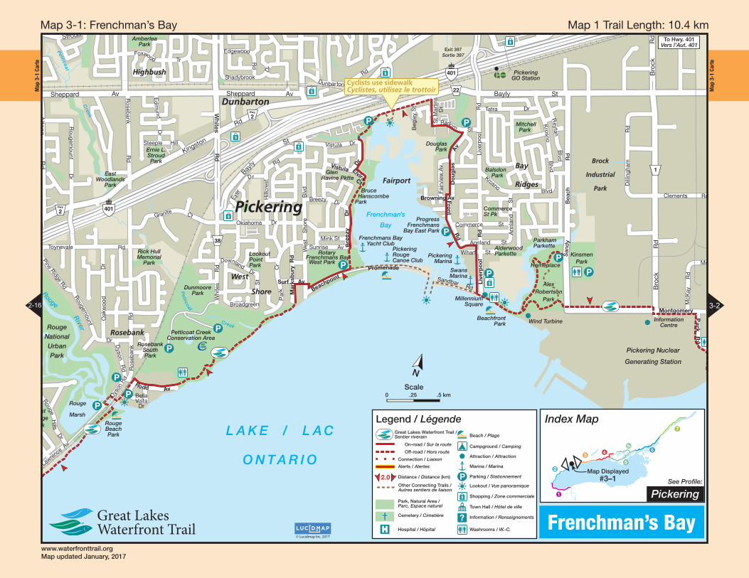
Map 2 Trail Length: 6.7 km Map 3-2 : Duffi ns Creek
www.waterfronttrail.orgMap updated January, 2017
Map
3-3
Car
te
Map
3-3
Car
te41
22
23
45
LakesideWaterfront
Park
Paradise Park
The StationGallery
Iroquois
Park
Ontario Shores Centre for
Mental Health Sciences
Lynde Shores
Conservation Area
Carruthers
Creek
Golf Centre
Capt. JamesRowe House
Museum
LyndeShores
ConservationArea
PickeringBeach
Ca
rruth
ers
Cre
ek
PortWhitby
Port Whitby
Harbour
Cranberry
Marsh
Lakeside
Carruthers Marsh
RichardsonPoint
ViewingPlatforms
ViewingPlatform
LakeridgeHealthWhitby
PP
PRotarySunrise
Park
WhitbyYacht Club
Port WhitbyMarina
J.A.urray
Park
P
P
WarblersWood and
Marsh
Paradise ParkBeach Area
WindsoBayPark
?
Carruthers Marsh Pavilion
Carruthers Marsh Pavilion
Whitby GOStation
P
P
P
LyndeCreekMarsh
Sho
al
Po
int
Tra
il
Exit 41Sortie 4
Iroquois Beach Park
Bridge crossing,cyclists dismountTraversée de pont,les cyclistes doiventdescendre.
$
Lake
Lake
R
idge
R
d
S
Victoria St W
Hen
ry
S
t
Lakeview Blvd
Sho
al
P
oint
R
d
Bayly St E
Sal
em
R
d
Bro
ck
St
S
Duf
ferin
S
t
Ch
arle
s S
tB
yron
St
S
Front St W
Watson St W
Hal
ls
R
d
S
Go
rdo
n
St
Eastbourne Beach Rd
Jeffe
ry
St
Sea
boa
rd
G
t
Portage Tr
Breakwater Dr
Whi
tb
y Shores Greenway
Wh
itby Shores Greenway
Whitb
y
Sh
ores
G
reen
wa y
Talls
hip
s
Dr
Nordeagle Av
Scadding Av
Pop
lar
Av
Map
le
AvRange Line Rd Range Rd
Ashbury Blvd
Audley Rd S
Aud
ley
R
d
S
Ontoro Blvd
Aud
ley
Tra
il
Aud
ley
Rd
S
Ajax
L A K E / L A C O N T A R I O
Port WhitbyPark
To Hwy. 401, Exit 404Vers l’Aut. 401, Sortie 404
Seasonal Access through Port Whitby Marina, June to September, 7 a.m. to 9 p.m.
Accès saisonnier par Port Whitby Marina, Juin à Septembre, 7 h-21 h
Legend / Légende
2.0
Great Lakes Waterfront Trail /Sentier riverain
On-road / Sur la routeOff-road / Hors route
Connection / Liaison
Alerts / Alertes
Distance / Distance (km)
Other Connecting Trails /Autres sentiers de liaison
Park, Natural Area /Parc, Espace naturel
Cemetery / Cimetière
$
P
?
Hospital / Hôpital
Beach / Plage
Campground / Camping
Attraction / Attraction
Marina / Marina
Parking / Stationnement
Lookout / Vue panoramique
Shopping /Zone commerciale
Town Hall / Hôtel de ville
Information /Renseignements
Washrooms / W.-C.
On-road / Sur la route
Off-road / Hors route
Trail to GO Connector Route /Sentier reliant à GO Transit
Index Map
AjaxSee Profile:
Map Displayed#3–3
1
2
3 4
5
5B6
7
© Lucidmap Inc. 2017
Lynde Shores
3-2 3-4
N
Scale0 .25 .5 km
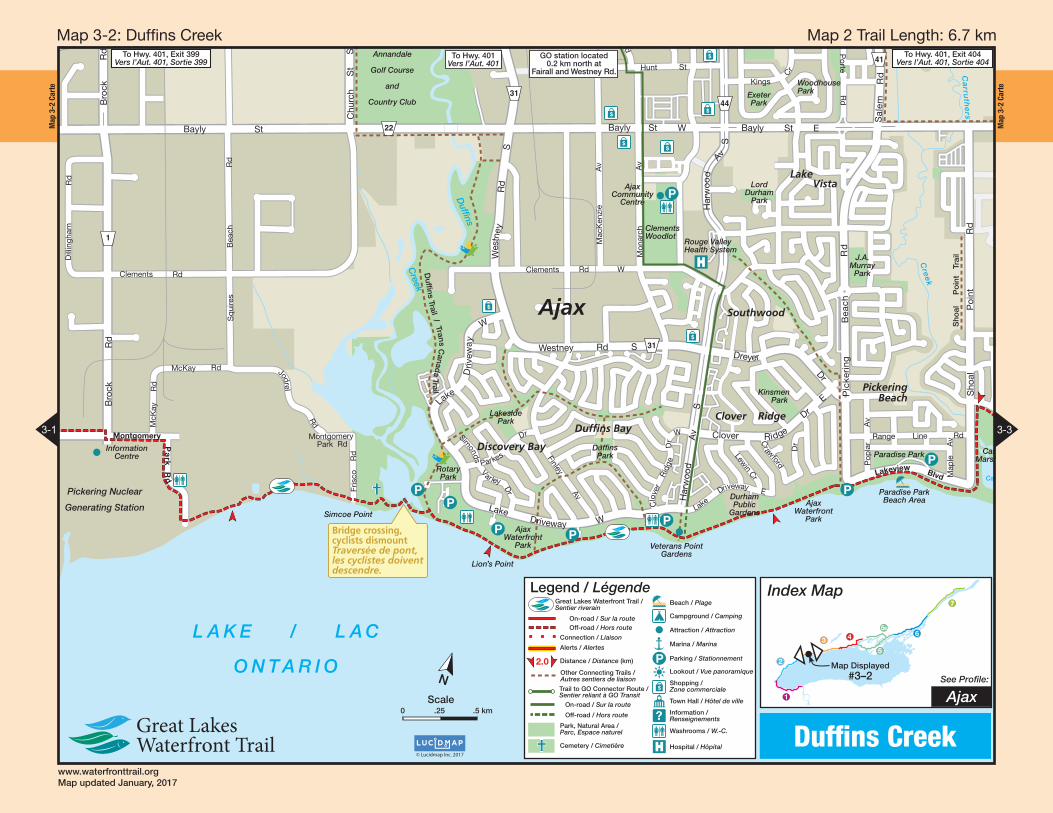
Map 3 Trail Length: 11.9 km Map 3-3 : Lynde Shores
www.waterfronttrail.orgMap updated January, 2017
Map
3-4
Car
te
Map
3-4
Car
te
45
401
26
22
25
52
60
53
52
401onery
ois
kDurham
College
Lake Park
HeydenshoreKiwanis Park
IntrepidPark
Lakefront West
Park
WhitbyEntertainment
Centrum
Capt. JamesRowe House
Museum
ThicksonWoods
Co
rbe
tt
PortWhitby
Port Whitby
Harbour
P
PRotarySunrise
Park
P
Thickson’s Point
WhitbyYacht Club
Port WhitbyMarina
WindsorBayPark
?
Camp XMemorial
Ronald CDeeth Park
Whitby GOStation
OshawaGO/VIA
Train Station
GoldPointMarsh
P
RenaissancePark
Up HillMontée
P
P
Exit 410Sortie 410
Iroquois Beach Park
Heydenshore Pavillion
Exit 412Sortie 412
Exit 416Sortie 416
$
$
$Consumers Dr
Wentworth St
Champlain Av
Th
icks
on
R
d
S
Victoria St
Hen
ry
S
t
Consumers Dr
Ste
vens
on
Rd
S
Phillip Murray Av
Bloor St W
Wentworth St W
Ste
ven
son
Rd
S
Tricont Av
Forb
es
S
t
Ho
pki
ns
S
t
So
uth
Bla
ir S
t
Water St
Har
bour
St
Bro
ck
St
S
Duf
ferin
S
t
Ch
arle
s S
tB
yron
St
S
Front St W
W
atson St W
Mc
Ewen Dr
William
Sm
ith
Dr
Bo
und
ary
Rd
Thor
nton
Rd
S
Terwillegar Av
Renaissance Dr
Victoria St
E
L A K E / L A C
O N T A R I O
Port WhitbyPark
Bridge / Heavy trucksPont / Camions lourds
Seasonal access through Port Whitby Marina, June to September, 7 a.m. to 9 p.m.
Accès saisonnier par Port Whitby Marina,Juin à Septembre, 7 h-21 h
WhitbyOshawa
Legend / Légende
2.0
Great Lakes Waterfront Trail /Sentier riverain
On-road / Sur la routeOff-road / Hors route
Connection / Liaison
Alerts / Alertes
Distance / Distance (km)
Other Connecting Trails /Autres sentiers de liaison
Park, Natural Area /Parc, Espace naturel
Cemetery / Cimetière
$
P
?
Hospital / Hôpital
Beach / Plage
Campground / Camping
Attraction / Attraction
Marina / Marina
Parking / Stationnement
Lookout / Vue panoramique
Shopping /Zone commerciale
Town Hall / Hôtel de ville
Information /Renseignements
Washrooms / W.-C.
On-road / Sur la route
Off-road / Hors route
Trail to GO Connector Route /Sentier reliant à GO Transit
Index Map
WhitbySee Profile:
Map Displayed#3–4
1
2
34
5
5B6
7
© Lucidmap Inc. 2017
Port Whitby
3-3 3-5
N
Scale0 .25 .5 km
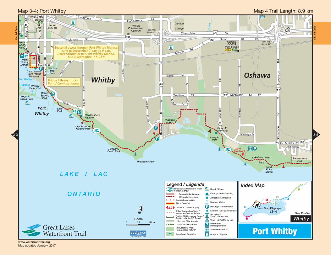
Map 4 Trail Length: 8.9 km Map 3-4 : Port Whitby
www.waterfronttrail.orgMap updated January, 2017
Map
3-5
Car
te
Map
3-5
Car
te
53
52
401
54
60
2
56
22
401Cordova
Park
KingsidePark
Chopin Park
Second Marsh
Wildlife Area
HarmonyCreek
Golf Centre
GrandviewSouth Park
Conant
ParkOshawa Valleylands Conservation Area
CordovaValleyPark
Lake VistaPark
Stone StreetPark
Pumphouse MarshWildlife Reserve
LakewoodsPark
OshawaCommunityMuseum& Archives
Lakeview Park
Southmead
Park
Oshawa
Creek
Har
mon y
Cre
ek
CedarDale
Oshawa
Harbour
Second
Marsh
McLaughlin Bay
JubileePavillion
PP
?
Oshawa
Up HillMontée
P
South OshawaCommunity Centre
GatehousePktte
McLaughlinPoint
RenaissancePark
Oshawa Valleylands Conservation Area
Exit 418Sortie 418
Exit 417Sortie 417
Exit 419Sortie 419
$
$
Wils
on
R
d
S
Bloor St E
Ste
vens
on
Rd
S
Par
k
R
d
S
Ced
ar
St
Phillip Murray Av
S tone St
Par
k R
d
S
Simcoe St S
Wentworth St
W
Simcoe St S
Harbour Rd
Far
ewel
l
St
Co
lon
el Sam
Dr
Colonel Sam Dr
Wentworth St E
Par
k
Rd
S
Grandview
Dr
Rits
on
Rd
S
Bloor St E
ndview S
t S
Ste
ven
son
Rd
S
Muskoka Av
Valley Dr
Klu
ane
A
v
Renaissance Dr
Bloor St
Tow
nlin
e
Rd
S
Fenn
ing
D
r
LakeviewPark Av
401
L A K E / L A C
O N T A R I O
Busy Road CrossingTraversée de rueachalandée
!
Busy Road CrossingTraversée de rueachalandée
!
Busy RoadRoute achalandée!
Legend / Légende
2.0
Great Lakes Waterfront Trail /Sentier riverain
On-road / Sur la route
Off-road / Hors route
Connection / Liaison
Alerts / Alertes
Distance / Distance (km)
Other Connecting Trails /Autres sentiers de liaison
Park, Natural Area /Parc, Espace naturel
Cemetery / Cimetière
$
P
?Hospital / Hôpital
Beach / Plage
Campground / Camping
Attraction / Attraction
Marina / Marina
Parking / Stationnement
Lookout / Vue panoramique
Shopping / Zone commerciale
Town Hall / Hôtel de ville
Information / Renseignements
Washrooms / W.-C.
Index Map
OshawaSee Profile:
Map Displayed#3–5
1
2
3 4
5
5B6
7
© Lucidmap Inc. 2017
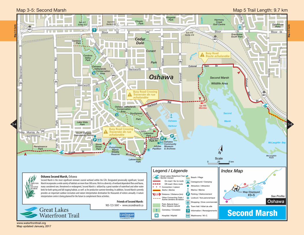
Second Marsh
3-4 3-6
Friends of Second Marsh:905-723-5047 • www.secondmarsh.ca
Oshawa Second Marsh, Oshawa Second Marsh is the most signifi cant remnant coastal wetland within the GTA. Designated provincially signifi cant, Second
Marsh incorporates a wide variety of habitats on more than 300 acres. Rich in a diversity of wetland dependent fl ora and fauna,
many considered rare, threatened or endangered, Second Marsh is utilized by a great number of waterfowl and other water
birds for both spring and fall staging habitat, as well as for productive summer breeding. In addition, Second Marsh currently
provides an important outdoor recreation and nature interpretation destination for thousands of visitors annually. A nature
interpretation centre is being planned for the future to complement these activities.
N
Scale0 .25 .5 km
Map 5 Trail Length: 9.7 km Map 3-5 : Second Marsh
www.waterfronttrail.orgMap updated January, 2017
Map
3-6
Car
te
Map
3-6
Car
te
401
22
34
401
Landfill
Site
St Vlodymyr &St Olha UkrainianCemetery
McLaughlin Bay
CN
EbenezerUnited ChurchCemetery
Darlington
Provincial
Park
Darlington Nuclear
Generating Station
CP
GatehousePktte
Robinson
Creek
To
ole
y
Cre
ek
DarlingtonStation
TooleyC
reek
McLaughlinPoint
L A K E / L A C
O N T A R I O
?
P
P
?
CootsPond
Bobolink Hill
Steep HillPente escarpée! Railway Crossing
Passage à niveau!Exit 425
Sortie 425
Han
cock
Co
urtic
e R
d
South Service Rd
Pre
sto
nval
e
R
d
Trul
ls
Rd
Bloor St
Co
urtic
e
R
d
Han
cock
Rd
Sol
ina
Sol
ina
Rd
Run
dle
Dr
Dr
Bloor St E
Baseline Rd W
Bloor St
Trul
ls
Co
urtic
e
Baseline Rd W
Bloor St
Tow
nlin
e
Rd
S
Cra
go
R
d
Energy Dr
Run
dle
Rd
Cra
go
R
d
Energy Dr
Crago Rd
Fenn
ing
D
r
P
Par
k
Rd
Rd
Mea
do
wglade
McLaughlin Bay
Wildlife
Reserve
Clarington
Stone dust trail notsuitable for roller bladesLe sentier en poussière depierre ne convient pas auxpatins à roues alignées
!
Southfield Av
Legend / Légende
2.0
Great Lakes Waterfront Trail /Sentier riverain
On-road / Sur la route
Off-road / Hors route
Connection / Liaison
Alerts / Alertes
Distance / Distance (km)
Other Connecting Trails /Autres sentiers de liaison
Park, Natural Area /Parc, Espace naturel
Cemetery / Cimetière
$
P
?Hospital / Hôpital
Beach / Plage
Campground / Camping
Attraction / Attraction
Marina / Marina
Parking / Stationnement
Lookout / Vue panoramique
Shopping / Zone commerciale
Town Hall / Hôtel de ville
Information / Renseignements
Washrooms / W.-C.
Index Map
ClaringtonSee Profile:
Map Displayed#3–6
1
2
3 4
5
5B6
7
© Lucidmap Inc. 2017
Darlington
3-5 3-7
N
Scale0 .25 .5 km
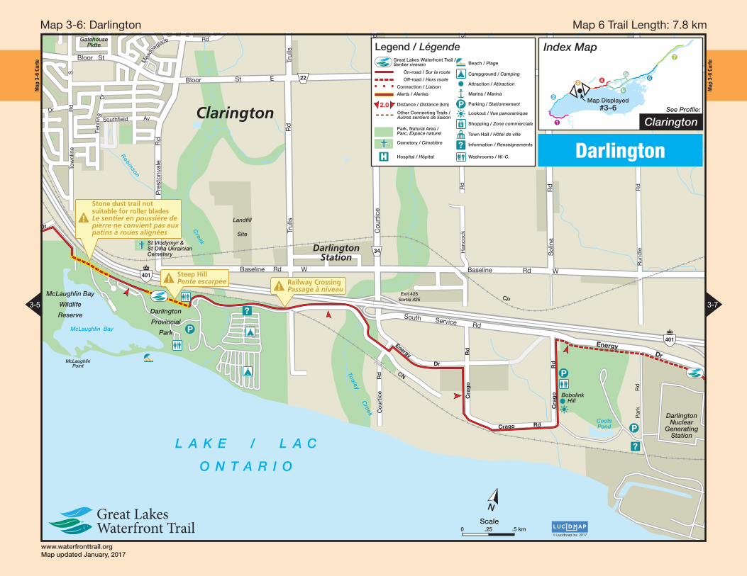
Map 6 Trail Length: 7.8 km Map 3-6 : Darlington
www.waterfronttrail.orgMap updated January, 2017
Map
3-7
Car
te
Map
3-7
Car
te
401
401
57
14
CN
EastBeach
Parkette
West Beach
Bowmanville/
Westside
Marshes
Conservation
Area
BowmanvilleCemetery
SoperCreek
Park
OptimistPark
BaselinePark
WestSidePark Visual
ArtsCentre
Darlington
Creek
Sid
e
Cre
ek
BowmanvilleC
re ek
Bowmanville
Port Darlington
PortDarlington
West
Raby Head
P
Cove BeachCedar Crest
Beach
Bow
manville
Valley Trail
WoodlotWalk
Tree FrogPond
Sop T
West SideMarsh
BowmanvilleLeash Free ParkNatural surface
Surface naturelle
Exit 429Sortie 429
Exit 431Sortie 431
Exit 432Sortie 432
GravelGravier
Hol
t
Rd
Energy Dr
Liberty S
t
Duke S
t
Haines S
t
Baseline RdBaseline Rd WBaseline Rd W
Energy D
r
Baseline Rd W
Po
rtD
arling
ton
Rd
East Beach Rd
West Beach Rd
Cove Rd
West
Beach
Rd
Ced
ar
Crest
Beach Rd
Waverley R
d
Run
dle
Dr
Par
k
Rd
L A K E / L A C
O N T A R I O
Use safety corralto cross Holt Rd.Utilisez le corridorde sécurité pourtraverser Holt Rd.
Clarington
Darlington Nuclear
Generating Station
East BeachP
Legend / Légende
2.0
Great Lakes Waterfront Trail /Sentier riverain
On-road / Sur la route
Off-road / Hors route
Connection / Liaison
Alerts / Alertes
Distance / Distance (km)
Other Connecting Trails /Autres sentiers de liaison
Park, Natural Area /Parc, Espace naturel
Cemetery / Cimetière
$
P
?Hospital / Hôpital
Beach / Plage
Campground / Camping
Attraction / Attraction
Marina / Marina
Parking / Stationnement
Lookout / Vue panoramique
Shopping / Zone commerciale
Town Hall / Hôtel de ville
Information / Renseignements
Washrooms / W.-C.
Index Map
ClaringtonSee Profile:
Map Displayed#3–7
1
2
3 4
5
5B6
7
© Lucidmap Inc. 2017
Bowmanville
3-6 3-8
N
Scale0 .25 .5 km
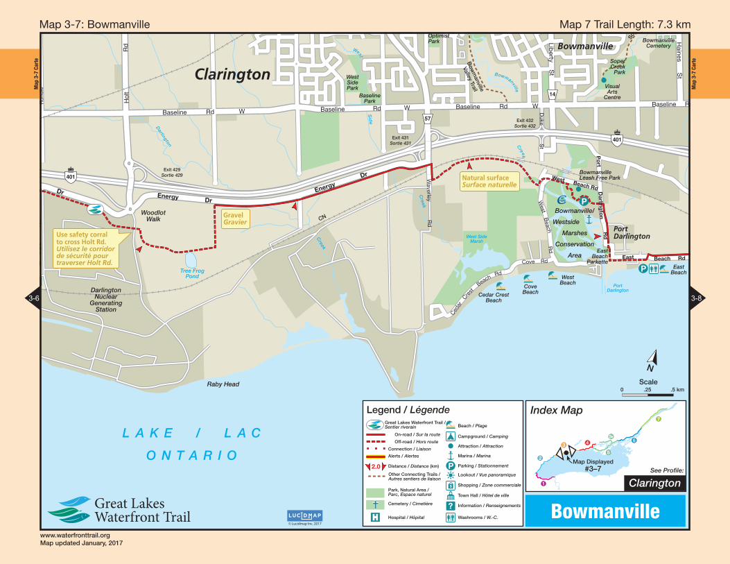
Map 7 Trail Length: 7.3 km Map 3-7 : Bowmanville
www.waterfronttrail.orgMap updated January, 2017
Map
3-8
Car
te
Map
3-8
Car
te Hwy
2 3511542
17
CN
Wilmot CreekCommunityGolf Course
Wilmot
Creek
Provincial
Fishing
Area
Edward Park
Foster CreekParkette
St GeorgesAnglican Cemetery
manvillemetery
Newcastle Lions Trail
Gra
ham
Creek
Fos t e
r
C r e e k
Wilmot Creek
Creek
Wi lmot
Newcastle
Samuel WimotNature Area
P
P
L A K E / L A C
O N T A R I O
Clarington
Exit 435Sortie 435
Exit 436Sortie 436 Exit/Sortie
440
Jim BoateHill
Bennett
Rd
King Av W
Lamb
sR
d B
ragg
Rd
Mill S
t S
Manvers Rd
Mill S
t S
Haines S
t
Baseline Rd E
P
ort
o
f
N
ew
castle
Dr
Beach Rd
Darlington-C
larke Townline
Wilmot Tr
Bluffs Rd
Wilmot Tr
The Cove
Rd
Kurve
InnRd
Cob
bled
ickR
d
So
uth
S
ervi
ce
Rd
Lake Rd
Birch Tree L
a
Wilm
ot Creek
Dr
Service Rd
TorontoS
t
Clarke St
Shipway Av
Lakebreeze Dr
Lovekin
Rd
115 35
Bal
dw
inS
t
401
Port of Newcastle
Marina
East BeachP
Legend / Légende
2.0
Great Lakes Waterfront Trail /Sentier riverain
On-road / Sur la route
Off-road / Hors route
Connection / Liaison
Alerts / Alertes
Distance / Distance (km)
Other Connecting Trails /Autres sentiers de liaison
Park, Natural Area /Parc, Espace naturel
Cemetery / Cimetière
$
P
?Hospital / Hôpital
Beach / Plage
Campground / Camping
Attraction / Attraction
Marina / Marina
Parking / Stationnement
Lookout / Vue panoramique
Shopping / Zone commerciale
Town Hall / Hôtel de ville
Information / Renseignements
Washrooms / W.-C.
Index Map
ClaringtonSee Profile:
Map Displayed#3–8
1
2
3 4
5
5B6
7
© Lucidmap Inc. 2017
Wilmot Creek
3-7 3-9
N
Scale0 .25 .5 km
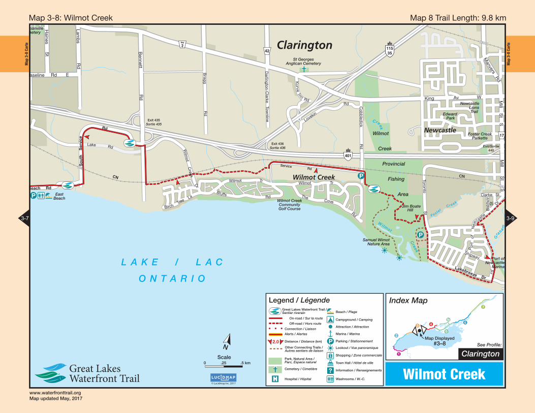
Map 8 Trail Length: 9.8 km Map 3-8 : Wilmot Creek
www.waterfronttrail.org Map updated May, 2017
Map
3-9
Car
te
F
reem
an
D
r
up hill
Ott
y Po
int
Ch
rysl
er P
oin
t
Wes
leyv
ille
Wes
leyv
ille
Gen
erat
ing
Sta
tio
n(d
orm
ant)
Port
B
rita
in
$
Wel
com
e
Port
H
op
e
LA
KE
/
LA
C
ON
TA
RIO
CN
CP
No
Sh
ou
lder
Pas
d’a
cco
tem
ent
!
No
Sh
ou
lder
Pas
d’a
cco
tem
ent
!
Hill
sC
olli
nes
up hill
up hill
up hill
Dal
e
R
d
Toronto R
d
Ser
vice
Cen
tre
East Townline Rd
Co
nces
sio
nR
d
1
Stacey Rd
Nichols Rd
Deer Park Rd
Mar
sh
R
d
Dickinson Rd
Haskill Rd
Brand RdBrand Rd
Baulch RdBaulch Rd
Rapley Blvd
Willow BeachRd
Lak
esho
re
R
d
Webster Rd
Mar
ydal
e P
ark
Rd
Mai
l
Rd
WallaceWoo Rd
PortBritain Rd
La
kesh
ore
R
d
401
2
2
10
Morrish Church Rd
Wesley
ville
Rd
McCullough Rd
Zion Rd
Roseberry Hill Rd
65
Map
3-9
Car
te
17
Durh
am
18
Form
erly
2
Hwy 2
401
18
2
CNC
P
Th
eG
len
Bo
nd
Hea
dC
emet
ery
New
cast
leM
emo
rial
Par
kA
nd
rew
Par
kett
e
Ser
vice
Cen
tre
Trav
elR
est
Are
aTrav
elR
est
Are
a
New
cast
le
Go
lf C
lub
Graham
Cre
ek
Port Granby
CreekN
ewca
stle
Bo
nd
Hea
d
Port
Gra
nb
y
New
ton
ville
978
Bo
uch
ette
Po
int
Cla
rin
gto
nP
ort
of
New
cast
leM
arin
a
No
Sh
ou
lder
Pas
d’a
cco
tem
ent
!
Mill St S
Kin
g
Av
E
Met
calf
St
Co
nces
sio
n
Rd
1
Morgans Rd
Lake
shor
e
Rd
East Townline Rd
Newtonville Rd
NewtonvilleRd
Co
nces
sio
n
Rd
1
Mac
do
nald
- C
artie
r F
reew
ay
Mill St S
Park La (St)
Stephenson Rd
Morgans Rd
Lake
sho
reR
d
Lake
sho
re R
dLakeshor
e
R
d
Nichols Rd
Lancaster Rd
Elliott Rd
JaynesRd
Riley Rd
Arthur St
Manvers Rd
Bo
ult
on
St
To H
wy.
401
, Exi
t 44
8Ve
rs l’
Au
t. 4
01, S
ort
ie 4
48
LA
KE
/
LA
C
ON
TA
RIO
Rai
lway
Cro
ssin
gPa
ssag
e à
niv
eau
!
17
17
401
18
2
CNC
PC
P
Th
eG
len
Bo
nd
Hea
dd
Hea
daddadadadadC
emet
ery
emyy
wca
stle
New
cas
New
ascaN
eeNN
ewwle
wwc
weNN
ewle
wca
stl
ewca
stM
emo
rial
Mem
Mem
Mo
Mem
ori
alri
alm
oM
eMM
emo
rial
rial
arP
ark
PPa
kkP
aP
arkrk
PPkk
nd
rew
Par
kett
eA
nd
AP
ewA
nd
ewA
ndd
rew
dre
weeeeee
Ser
vice
Cen
tre
tre
Ce
CCeeee
Trav
elR
est
RR Are
aA
Trav
elR
est
Are
a
cast
leN
ewca
stle
New
cN
ewc
Go
lf C
lub
Clu
bG
olf
C
Grahamm
Cr
Cer
ee
k
PPPortr Grar nby
CreekkkkkNNN
ewca
stlee
ewca
se
cacaaaNNN
Bo
nd
d
HHHea
dea
daaeeeeHHHH
PoPPrt
Gra
nb
yrr
97888
Bo
uch
ette
Po
int
PP
CClla
rin
gn
aato
nP
ort
of f
of
Po
rt o
Po
rto
fP
ort
of
New
cast
leM
arin
a
No
Sh
ou
lder
Pas
d’a
cco
tem
ent
!
SSSS St Mill StSMill St Mil t t S MMill Stl
Kin
g
Av
E
K
inng
Av
g
gKK
ing
A
v
KK
ing
g
g
Met
calf
St
calf
ca
lf C
onc
essi
on
R
d
1
Co
nc
d
o
o
Morgans Rd sMorgag
Lake
shor
eRR
dd
nline RdRdEast TownE Towwwnn
Newtonville Rdonon ll
Mac
do
nald
- C
artie
r F
reew
ayyy
Mill St SMill St SSllMill St S S l
Park LaPark LaPaarrk Laaark La(St)(St(St
Stephenson Rd onensontS h Rdn S
Morgans Rd Morgag
Lake
sho
reR
d
d
R
Lake
sho
re R
dsh
re R
dsh
Lakeesshooh
rreerRR
dd
Nichols Rdch
aster RddLancacaa
EElliott RRd
JaynesesyyRddRd
Riley Rdy R
Arthur St SSSStSS
Manvers RddRRdRds s
ton
Bo
ult
oB
ou
lto
uB
ou
ltuaaaa
S St
To H
wTT
y. 4
01,
yyE
xit
448
Vers
l’VV
A’u
t.tt 4
01, S
ort
ie 4
48rr
LA
KE
/
LA
C
ON
TA
RIO
TT
Rai
lway
Cro
ssin
gPa
ssag
e à
niv
eau
!
Leg
end
/ L
égen
de
2.0
Gre
at L
akes
Wat
erfr
ont
Tra
il /
Sen
tier
rive
rain
On-
road
/ S
ur la
ro
ute
Off
-ro
ad /
Ho
rs r
out
e
Co
nnec
tion
/ Li
aiso
n
Ale
rts
/ A
lert
es
Dis
tanc
e /
Dis
tanc
e (k
m)
Oth
er C
onn
ectin
g T
rails
/A
utre
s se
ntie
rs d
e lia
iso
n
Par
k, N
atur
al A
rea
/P
arc,
Esp
ace
natu
rel
Cem
eter
y /
Cim
etiè
re
$P ?H
osp
ital /
Hô
pita
l
Bea
ch /
Pla
ge
Cam
pg
roun
d /
Cam
pin
g
Att
ract
ion
/ A
ttra
ctio
n
Mar
ina
/ M
arin
a
Par
king
/ S
tatio
nnem
ent
Loo
kout
/ V
ue p
ano
ram
ique
Sho
pp
ing
/ Z
one
co
mm
erci
ale
Tow
n H
all /
Hô
tel d
e vi
lle
Info
rmat
ion
/ R
ense
igne
men
ts
Was
hro
om
s /
W.-
C.
Ind
ex M
ap Cla
ring
ton
/ P
ort
Ho
pe
See
Pro
file:
Map
Dis
pla
yed
#3–9
1
2
34
55B6
7
© L
ucid
map
Inc.
201
7
Port
Gra
nby
/ W
esle
yvill
e
© L
ucid
map
Inc.
201
7
Co
ntin
ued
Bel
ow
Co
ntin
ued
Ab
ove
3-8
3-10
NS
cale
0.5
1 km
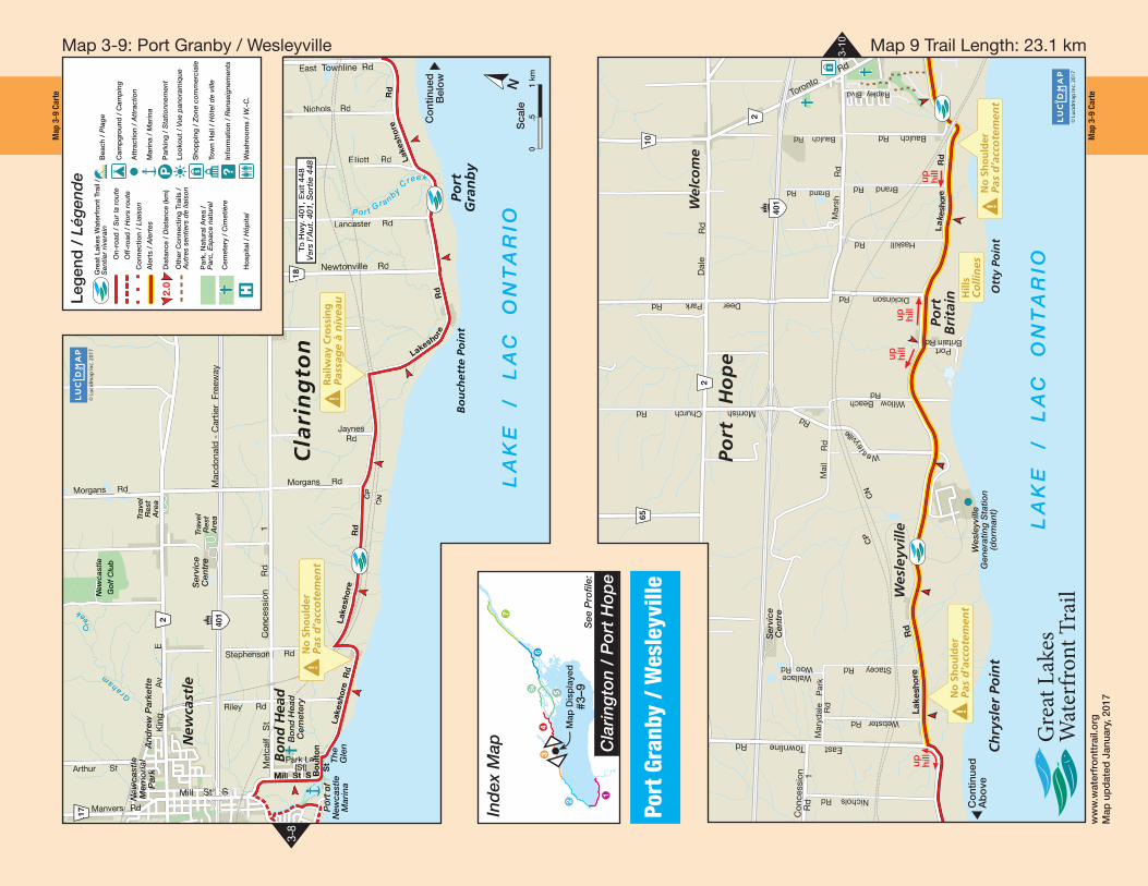
Map 9 Trail Length: 23.1 km Map 3-9 : Port Granby / Wesleyville
ww
w.w
ater
fro
nttr
ail.o
rgM
ap u
pd
ated
Jan
uary
, 201
7
Map
3-1
0 Ca
rte
Map
3-1
0 Ca
rte
Port HopeHarbour
L A K E / L A C O N T A R I O
Gan
aras
ka
Riv
er
MonkeyMountain
Alice KingSculthorpeWoodland
Marsh
Ganaraska Region
Conservation Area
KiwanisPark
WladykaPark
KingsField Park
Penryn Park
Golf Course
West Beach Park
CN
LakeviewEstates
Park
TownAgricultural
Park
OliversLadder
CaldwellBeach
Marina Beach Park
FirefightersMuseum
PeacePark
Gan
aras
ka
Tr
ail
Caroline StPark
JacobsLadder
RomanCatholic
EpiscopalCemetery
UnionCemetery
WelcomeCemetery
OptimistPark
Ralph HodgsonMemorial Park
Margles
Park
CapitolTheatre
CP
CN
$
P
P
$
$
PPPort Hope
Yacht Club
TownRecreation
Centre
$
P
Keith RichanWalkway
401
Up HillMontée
No ShoulderPas d’accotement!
Very soft surfaceSurface très meuble
$
$
70
401
2
28
2
Exit / Sortie 464
Exit / Sortie 461
HillColline!
Gag
e’s
Cre
ek
Jocelyn StJocelyn St Molson St
Ros
e
Gle
n
Rd
N
Ont
ario
St
Toronto Rd
Ridout St
Ros
e G
len
R
d
S
Peter St
Mill
St
Walton St
Rose Glen Rd
Fox
Rd
Bau
lch
Rd
Bau
lch
R
d
Rap
ley
B
lvd
Ham
ilton
R
d
Lake St
Kin
g S
t
Mill
St
S
Trafalgar St Dorset St W
Vic
tori
a S
t S
Hayward St
Ho
pe
St
John
St
Choate Rd
Cra
nber
ry
Rd
Wel
lingt
on
S
t
Cav
an
St
Scr
iven
Blv
d
Lavinia St
Hop
e
St
N
Ward
St
Ont
ario
S
t
Fr
e eman Dr
Hop
e
St
N
Hop
e
St
S
Dorset St EKin
g
St
Nel
son
St
Que
en S
t
Charles St
Vic
toria
S
t
N
Pin
e
St
Marsh St
Ham
ilton
R
d
Croft St
Lakeshore Rd
Augusta StSherbourne St
Telephone Rd
Port Hope
Greenbelt Route - 470 kmsigned cycling route fromNorthumberland to Niagara.
Index Map
Port HopeSee Profile:
Map Displayed#3–10
1
2
34
5
5B6
7
© Lucidmap Inc. 2017
Port Hope
3-9 4-1
Beach / Plage
Campground / Camping
Attraction / Attraction
Marina / Marina
Parking / Stationnement
Lookout / Vue panoramique
Shopping / Zone commerciale
Town Hall / Hôtel de ville
Information / Renseignements
Washrooms / W.-C.
Great Lakes Waterfront Trail / Sentier riverain
On-road / Sur la route
Off-road / Hors route
Connection / Liaison
Alerts / Alertes
Distance / Distance (km)
Apple Route /Route de la pommeGreenbelt Route /Sentier GreenbeltOther Connecting Trails /Autres sentiers de liaison
Park, Natural Area /Parc, Espace naturel
Cemetery / Cimetière
Legend / Légende
$
P
?
2.0
NScale
0 .25 .5 km
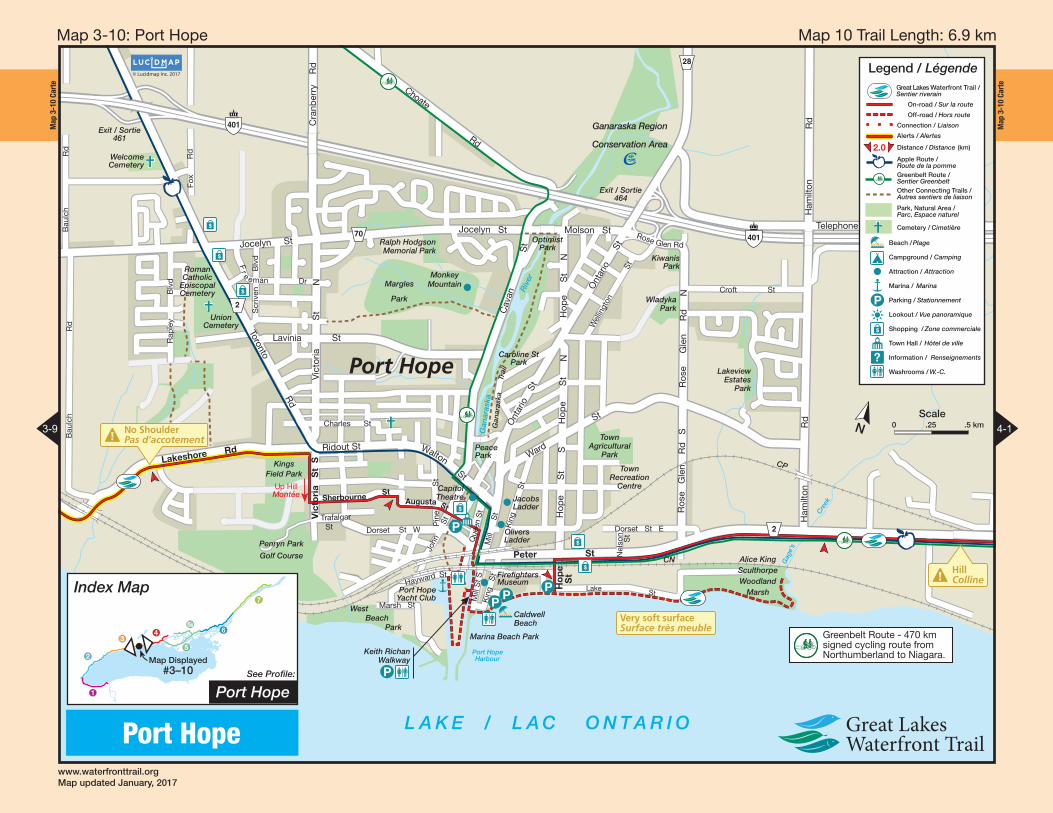
Map 10 Trail Length: 6.9 km Map 3-10 : Port Hope
www.waterfronttrail.orgMap updated January, 2017