Embed Size (px)
Citation preview
Journal of Environmental Science and Engineering B 3 (2014) 304-315 doi: 10.17265/2162-5263/2014.06.003
Groundwater in Thailand
Juan Fornés1 and Kriangsak Pirarai2
1. Department of Research and Geoscientific Prospective, Geological and Mining Institute of Spain, Ministry of Economy, Madrid
28003, Spain
2. Bureau of Groundwater Resources Region 4, Department of Groundwater Resources, Ministry of Natural Resources and
Environment, Khon Kaen 40000, Thailand
Abstract: This article offers a brief description of the water resources situation of the Kingdom of Thailand, a country with a population of over 65 million people and a surface area of 513,120 km2. The average annual rainfall is 1,430 mm and the total water resources are estimated at 215,000 Mm3 (million of m3)·year-1. The hydric demand in the country is 70,000 Mm3·year-1, 6% of which is groundwater in origin. Over 70% of the water is used for agriculture. Thailand is the world’s leading exporter of rice. The main problems faced by the Water Authority in Thailand are pollution, floods and droughts, depending on the geographical zone. From the hydrogeological point of view, the Central Plain is the main groundwater reservoir in the nation. Intensive extraction of groundwater over a long period of time has caused three main problems: a decline in groundwater levels, land subsidence, and seawater intrusion. These problems have been especially pressing in the area known as Greater Bangkok. Key words: Bangkok, environmental impact, groundwater exploitation, Thailand, water supply.
1. Introduction
The Kingdom of Thailand has a surface area of
513,120 km2 (Fig. 1). The country extends over 1,500
km from north to south and 800 km from east to west.
Thailand has frontiers with Malaysia to the south,
Myanmar to the west and north-west, Laos to the
north-east, and Cambodia to the south-east. It has a
population of over 65 million and a population density
of 123 inhabitants per km2. Bangkok, its capital city,
has a population around 13 million. It is the world’s
leading exporter of rice. In the 19th century,
Bangkok’s population was only one million people.
Thailand can be divided into four geographical
regions: the north, the central plain, the north-east, and
the south. The north is mountainous and it is here that
the four main rivers have their sources (Ping, Wang,
Yom and Nan), which go on to form the mighty Chao
Phraya on the Central Plain. The north eastern part
covers one third of the total surface area of the country
and consists of a topographic platform range between
Corresponding author: Juan Fornés, Ph.D., research fields: groundwater investigation and wetlands. E-mail: [email protected].
100 m and 200 m above sea level. Large areas of this
region suffer from major flooding and long droughts.
Productivity is generally low due to the soil salinity in
this area.
The average annual rainfall is around 1,430 mm,
amounting to a total 735,000 Mm3 (million of m3) of
volume of rain: 417,000 Mm3·year-1 of this quantity
(almost 57%) is lost due to evapotranspiration; the
average groundwater recharge is 103,000 Mm3·year-1
(14%); and the surface runoff is around 215,000
Mm3·year-1 (29%). Water demand in Thailand is
around 70,000 Mm3·year-1, 22% of the renewable
resources per year. The current groundwater
abstraction is 11,047 Mm3·year-1 (almost 11% of
recharge). The country has groundwater storage of
1,130,000 Mm3 and a surface storage of 76,000 Mm3
(Fig. 2). The agricultural sector is the main user of
surface water (70% of the total). There are 25 main
drainage basins which are included in these six
groundwater basins: North, Upper Central, Lower
Central, Northeast, East and South. The number of
hydrogeologists working at those basins seems to be
not appropriated.
D DAVID PUBLISHING
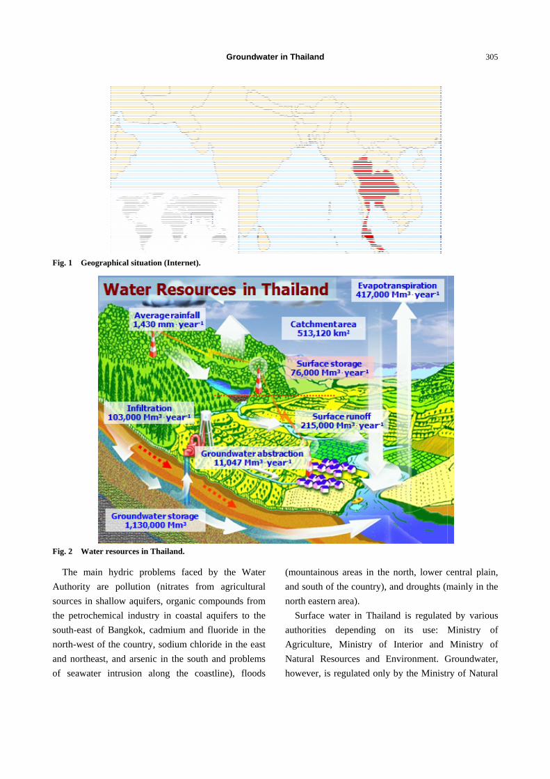
Fig. 1 Geog
Fig. 2 Wate
The main
Authority a
sources in s
the petroche
south-east o
north-west o
and northea
of seawater
raphical situat
er resources in
n hydric pro
are pollution
hallow aquif
emical indust
of Bangkok,
of the country
st, and arsen
r intrusion a
tion (Internet)
Thailand.
oblems faced
n (nitrates fr
fers, organic
try in coasta
cadmium an
y, sodium ch
nic in the sou
along the c
Groun
.
d by the W
from agricult
compounds f
al aquifers to
d fluoride in
hloride in the
uth and probl
oastline), flo
ndwater in Th
Water
tural
from
o the
n the
east
lems
oods
(mo
and
nort
S
auth
Agr
Nat
how
hailand
ountainous ar
d south of the
th eastern are
Surface water
horities dep
riculture, Mi
tural Resourc
wever, is regu
reas in the n
e country), an
ea).
r in Thailand
pending on
inistry of In
ces and Env
ulated only b
north, lower c
nd droughts (m
d is regulated
its use:
nterior and
vironment. G
by the Ministr
305
central plain,
mainly in the
d by various
Ministry of
Ministry of
Groundwater,
ry of Natural
5
,
e
s
f
f
,
l
Groundwater in Thailand
306
Resources and Environment through the Department
of Groundwater Resources. Groundwater in Thailand
belongs to the public hydraulic domain.
2. Results and Discussion
2.1 Central Plain Groundwater
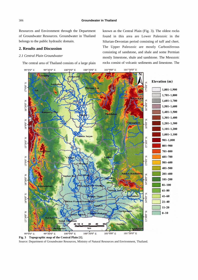
The central area of Thailand consists of a large plain
known as the Central Plain (Fig. 3). The oldest rocks
found in this area are Lower Paleozoic in the
Silurian-Devonian period consisting of tuff and chert.
The Upper Paleozoic are mostly Carboniferous
consisting of sandstone, and shale and some Permian
mostly limestone, shale and sandstone. The Mesozoic
rocks consist of volcanic sediments and limestone. The
Fig. 3 Topographic map of the Central Plain [1]. Source: Department of Groundwater Resources, Ministry of Natural Resources and Environment, Thailand.
Groundwater in Thailand
307
Tertiary rocks are entirely covered by the Quaternary
sediments of which the thickness ranges from 650 m
to 1,830 m [1].
The Central Plain is divided into two regions: the
Upper Central Plain and the Lower Central Plain. The
Upper Central Plain, which is the area north of Pak
Nam Po—where the main four rivers Ping, Wang, Yom
and Nan converge to form the Chao Phraya—consists
of an undulating terrain averagely 40-60 m above
mean sea level. The sediments deposited in this region
are the result of fluvial processes forming flood plains,
terraces and swamps [1].
The Lower Central Plain, from Pak Nam Po to the
Chao Phraya River mouth, is averagely 20 m above
mean sea level. The area consists of tidal flats,
marshes, deltas, beaches, and sand bars with
numerous Chao Phraya River’s fluvial characteristics
such as ox-bow lakes and meander scars [1].
The Central Plain was formed from three major
faults that appeared at the end of Cretaceous and
beginning of Tertiary. The deposits are entirely
terrestrial consisting of alluvial fans, alluvial plains,
streams and lakes [1].
From the hydrogeological point of view, the Central
Plain is the main reservoir of groundwater in the
country. Groundwater is found from unconsolidated
sediments of the Chao Phraya-Tha Chin Basin which
consist of alluvial and colluvial deposits and river
terraces. In some areas near the eastern edge of the
Central Plain, groundwater from hard rocks can also
be extracted [1].
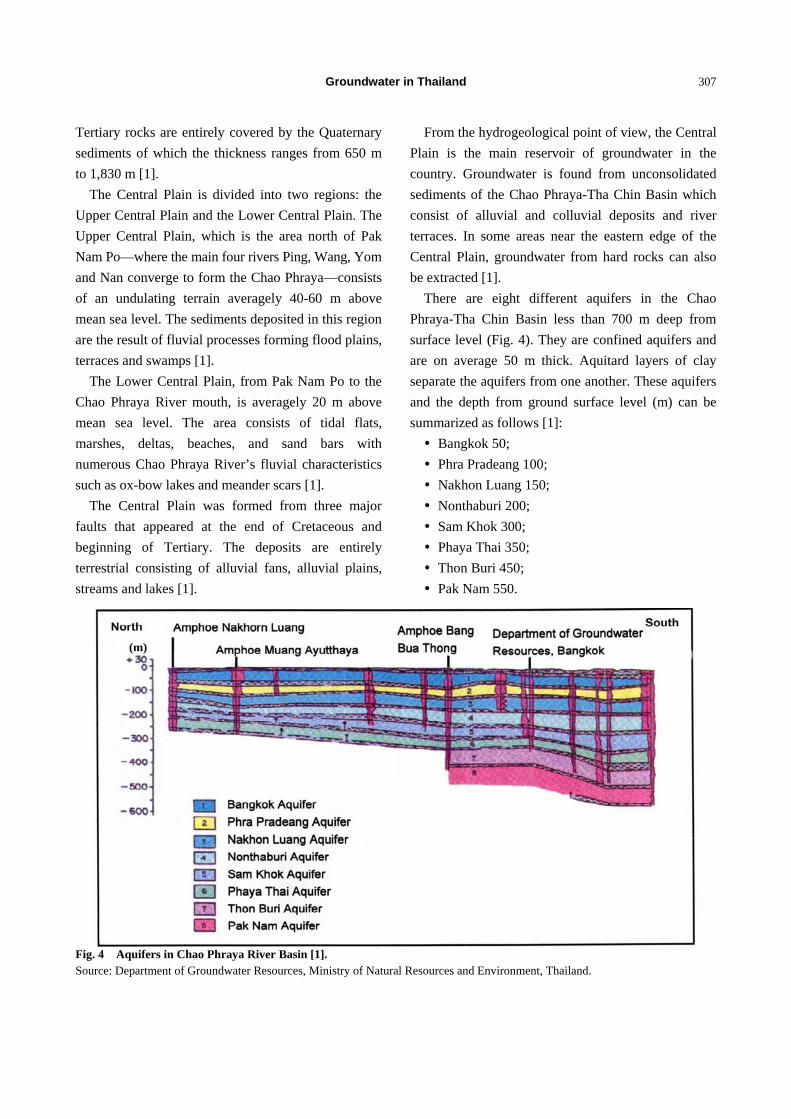
There are eight different aquifers in the Chao
Phraya-Tha Chin Basin less than 700 m deep from
surface level (Fig. 4). They are confined aquifers and
are on average 50 m thick. Aquitard layers of clay
separate the aquifers from one another. These aquifers
and the depth from ground surface level (m) can be
summarized as follows [1]:
Bangkok 50;
Phra Pradeang 100;
Nakhon Luang 150;
Nonthaburi 200;
Sam Khok 300;
Phaya Thai 350;
Thon Buri 450;
Pak Nam 550.
Fig. 4 Aquifers in Chao Phraya River Basin [1]. Source: Department of Groundwater Resources, Ministry of Natural Resources and Environment, Thailand.
(m)
Groundwater in Thailand
308
2.2 Groundwater Use
The groundwater use in Thailand started in
Bangkok in 1907. The first two wells were dug in
front of Suthat Thep Wararam Temple. The extraction
of this resource from the aquifers of Bangkok
(Bangkok, Ayutthaya, Samut Prakan, Samut Sakorn,
Nonthaburi and Patumthani) reached 2.225 Mm3·day-1
in 2002: 0.809 Mm3 for domestic use; 1.409 Mm3 for
industrial use; and 0.007 Mm3 for agricultural use [1].
Since 2004, groundwater use was continuingly
going down due to strict control exercised through the
groundwater management under the Groundwater Act.
The control measures comprised of the additional
groundwater conservation fee charged together with
the groundwater use fee plus discontinuation of water
wells in areas where pipe water supply reached. In
2008, groundwater use in those areas was about 0.75
Mm3·day-1 [1].
The current groundwater abstraction, in the whole
country, is 11,047 Mm3·year-1: 4,840 Mm3 for
agriculture (44%), 4,085 Mm3 for industry (37%), and
2,122 Mm3 for domestic use (19%). Groundwater is
used during the two dry seasons and mainly in rural
areas. According to the National Statistic Office, in
2008 there were 1,405,401 dug wells and 738,406
groundwater wells.
2.3 Environmental Impacts
For a long period, there has been extraction of
groundwater at a rate higher than that could be
recharged naturally, and has caused three main
environmental problems: a decline in groundwater
levels, land subsidence, and seawater intrusion.
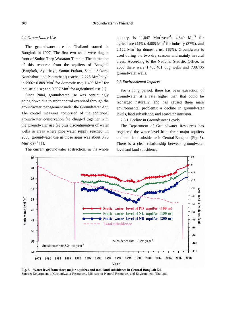
2.3.1 Decline in Groundwater Levels
The Department of Groundwater Resources has
registered the water level from three major aquifers
and total land subsidence in Central Bangkok (Fig. 5).
There is a clear relationship between groundwater
level and land subsidence.
Fig. 5 Water level from three major aquifers and total land subsidence in Central Bangkok [2]. Source: Department of Groundwater Resources, Ministry of Natural Resources and Environment, Thailand.
Subsidence rate 1.3 cm·year-1
Subsidence rate 3.24 cm·year-1
Groundwater in Thailand
309
By 2004, groundwater levels generally declined
considerably in the Chao Phraya-Tha Chin Basin due
to extensive groundwater pumping. In some areas of
Amphoe Krathum Baen and Samut Sakorn, the water
levels were at 65-70 m below ground surface. After
the groundwater conservation charge is introduced,
the water levels had significantly recovered between
2.6 m·year-1 and 3 m·year-1 and in 2008 coming up to
28-48 m below ground surface. However, in other
areas such as Amphoe Muang Samut Sakorn, this
recovery was still low due to intense groundwater
pumping [1].
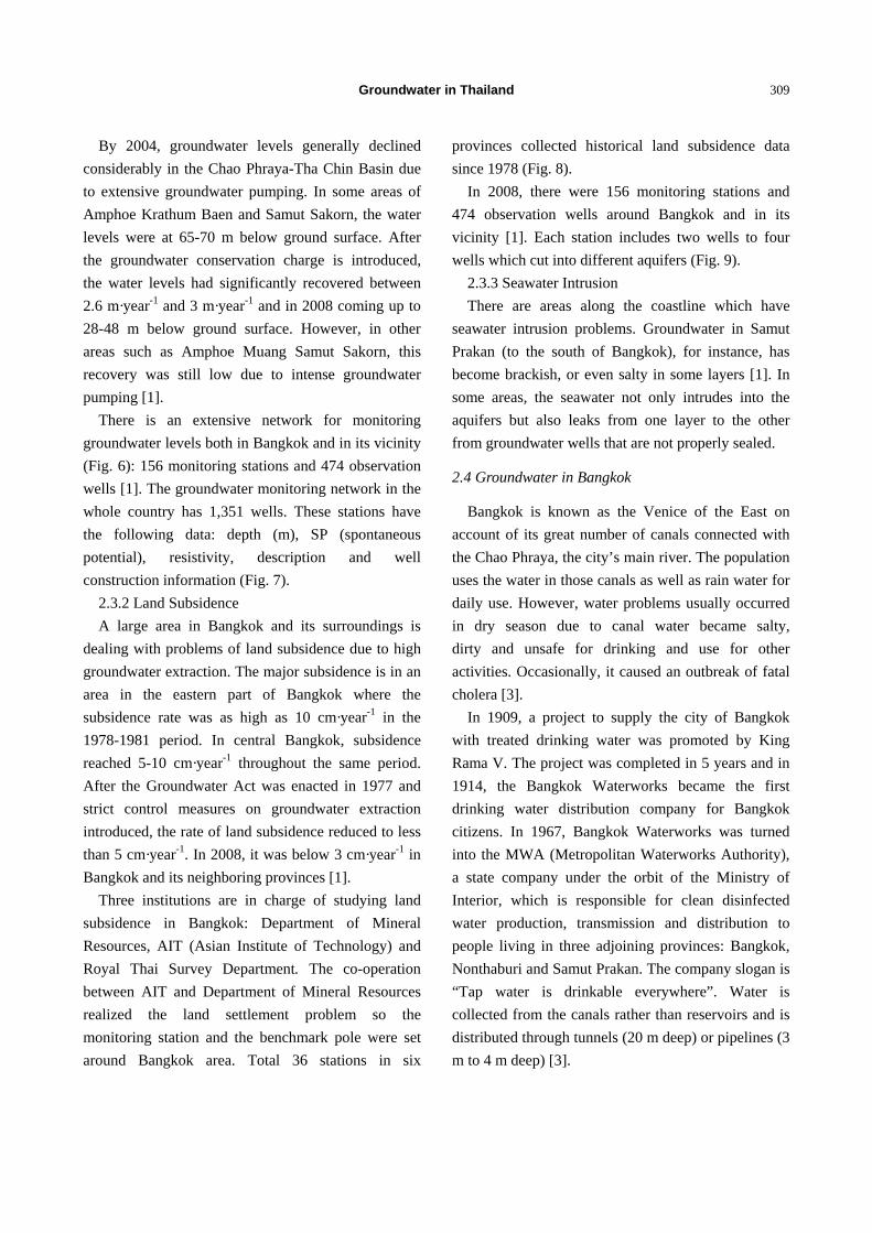
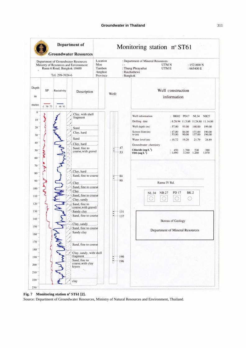
There is an extensive network for monitoring
groundwater levels both in Bangkok and in its vicinity
(Fig. 6): 156 monitoring stations and 474 observation
wells [1]. The groundwater monitoring network in the
whole country has 1,351 wells. These stations have
the following data: depth (m), SP (spontaneous
potential), resistivity, description and well
construction information (Fig. 7).
2.3.2 Land Subsidence
A large area in Bangkok and its surroundings is
dealing with problems of land subsidence due to high
groundwater extraction. The major subsidence is in an
area in the eastern part of Bangkok where the
subsidence rate was as high as 10 cm·year-1 in the
1978-1981 period. In central Bangkok, subsidence
reached 5-10 cm·year-1 throughout the same period.
After the Groundwater Act was enacted in 1977 and
strict control measures on groundwater extraction
introduced, the rate of land subsidence reduced to less
than 5 cm·year-1. In 2008, it was below 3 cm·year-1 in
Bangkok and its neighboring provinces [1].
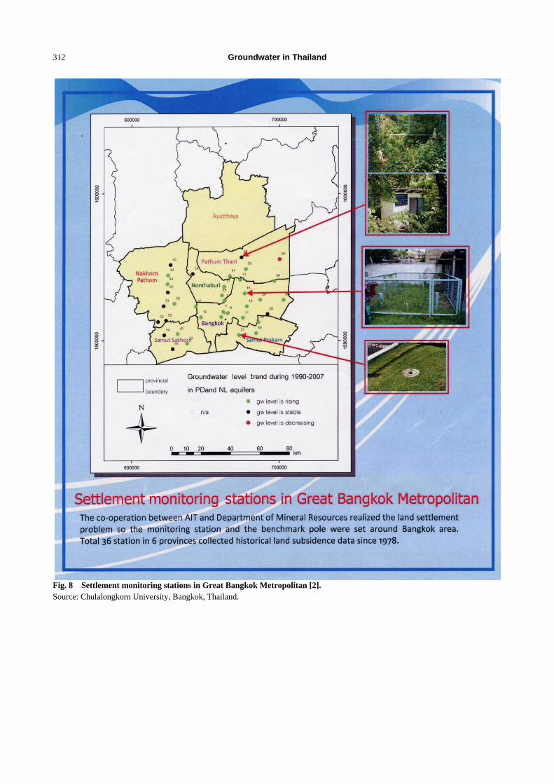
Three institutions are in charge of studying land
subsidence in Bangkok: Department of Mineral
Resources, AIT (Asian Institute of Technology) and
Royal Thai Survey Department. The co-operation
between AIT and Department of Mineral Resources
realized the land settlement problem so the
monitoring station and the benchmark pole were set
around Bangkok area. Total 36 stations in six
provinces collected historical land subsidence data
since 1978 (Fig. 8).
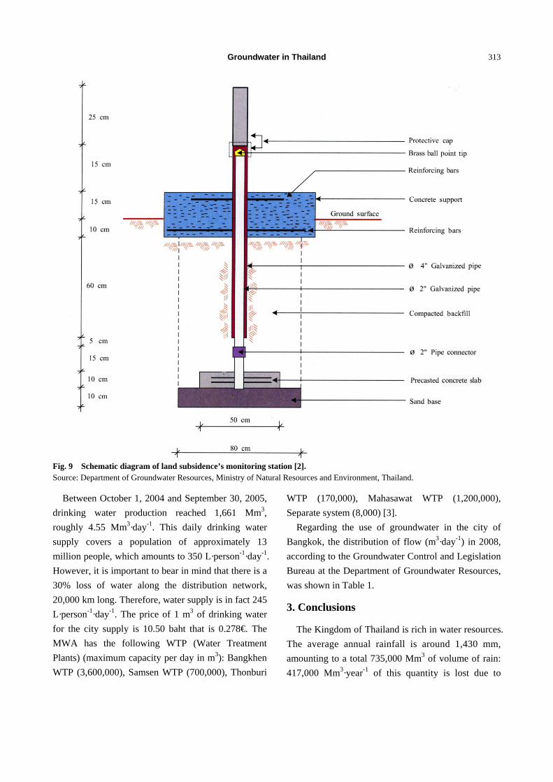
In 2008, there were 156 monitoring stations and
474 observation wells around Bangkok and in its
vicinity [1]. Each station includes two wells to four
wells which cut into different aquifers (Fig. 9).
2.3.3 Seawater Intrusion
There are areas along the coastline which have
seawater intrusion problems. Groundwater in Samut
Prakan (to the south of Bangkok), for instance, has
become brackish, or even salty in some layers [1]. In
some areas, the seawater not only intrudes into the
aquifers but also leaks from one layer to the other
from groundwater wells that are not properly sealed.
2.4 Groundwater in Bangkok
Bangkok is known as the Venice of the East on
account of its great number of canals connected with
the Chao Phraya, the city’s main river. The population
uses the water in those canals as well as rain water for
daily use. However, water problems usually occurred
in dry season due to canal water became salty,
dirty and unsafe for drinking and use for other
activities. Occasionally, it caused an outbreak of fatal
cholera [3].
In 1909, a project to supply the city of Bangkok
with treated drinking water was promoted by King
Rama V. The project was completed in 5 years and in
1914, the Bangkok Waterworks became the first
drinking water distribution company for Bangkok
citizens. In 1967, Bangkok Waterworks was turned
into the MWA (Metropolitan Waterworks Authority),
a state company under the orbit of the Ministry of
Interior, which is responsible for clean disinfected
water production, transmission and distribution to
people living in three adjoining provinces: Bangkok,
Nonthaburi and Samut Prakan. The company slogan is
“Tap water is drinkable everywhere”. Water is
collected from the canals rather than reservoirs and is
distributed through tunnels (20 m deep) or pipelines (3
m to 4 m deep) [3].
Groundwater in Thailand
310
Fig. 6 Groundwater monitoring stations in Bangkok and its surroundings [2]. Source: Department of Groundwater Resources, Ministry of Natural Resources and Environment, Thailand.
100.5
100.5
14.5
14.5
13.5
13.5
Groundwater in Thailand
311
Fig. 7 Monitoring station nº ST61 [2]. Source: Department of Groundwater Resources, Ministry of Natural Resources and Environment, Thailand.
Chloride (mg·L-1) TDS (mg·L-1)
Groundwater in Thailand
312
Fig. 8 Settlement monitoring stations in Great Bangkok Metropolitan [2]. Source: Chulalongkorn University, Bangkok, Thailand.
Groundwater in Thailand
313
Fig. 9 Schematic diagram of land subsidence’s monitoring station [2]. Source: Department of Groundwater Resources, Ministry of Natural Resources and Environment, Thailand.
Between October 1, 2004 and September 30, 2005,
drinking water production reached 1,661 Mm3,
roughly 4.55 Mm3·day-1. This daily drinking water
supply covers a population of approximately 13
million people, which amounts to 350 L·person-1·day-1.
However, it is important to bear in mind that there is a
30% loss of water along the distribution network,
20,000 km long. Therefore, water supply is in fact 245
L·person-1·day-1. The price of 1 m3 of drinking water
for the city supply is 10.50 baht that is 0.278€. The
MWA has the following WTP (Water Treatment
Plants) (maximum capacity per day in m3): Bangkhen
WTP (3,600,000), Samsen WTP (700,000), Thonburi
WTP (170,000), Mahasawat WTP (1,200,000),
Separate system (8,000) [3].
Regarding the use of groundwater in the city of
Bangkok, the distribution of flow (m3·day-1) in 2008,
according to the Groundwater Control and Legislation
Bureau at the Department of Groundwater Resources,
was shown in Table 1.
3. Conclusions
The Kingdom of Thailand is rich in water resources.
The average annual rainfall is around 1,430 mm,
amounting to a total 735,000 Mm3 of volume of rain:
417,000 Mm3·year-1 of this quantity is lost due to
Groundwater in Thailand
314
Table 1 Distribution of flow (m3·day-1) in Bangkok (2008).
No. of wells Percentage (%) Q allowed Percentage (%) Q real Percentage (%)
Industrial 144 51 49,251 77 5,664 49
Domestic 89 31 10,257 16 4,188 37
Services 19 7 3,484 5 656 6
Commercial 17 6 728 1 550 5
Agricultural 13 5 523 1 283 3
Total 282 100 64,243 100 11,341 100
evapotranspiration; the infiltration is 103,000 Mm3·year-1;
and the surface runoff is around 215,000 Mm3·year-1.
Water demand in Thailand is around 70,000 Mm3·year-1,
22% of the annual renewable resources. The current
groundwater abstraction, in the whole country, is
11,047 Mm3·year-1 (almost 11% of recharge). The
country has groundwater storage of 1,130,000 Mm3
and a surface storage of 76,000 Mm3. The agricultural
sector is the main user of surface water (70% of the
total). There are 25 main drainage basins which are
included in these six groundwater basins: North, Upper
Central, Lower Central, Northeast, East and South.
The country is the world’s leading exporter of rice.
Water management is highly decentralized
as—depending on its use—it is controlled by the
Ministry of Agriculture, the Ministry of the Interior or
the Ministry of Natural Resources and the
Environment. Groundwater, however, falls solely
under the latter, specifically under the Department of
Groundwater Resources and belongs to the public
hydraulic domain. The main reservoir of groundwater
in the country is in the Central Plain.
The main problems faced by the Water Authority in
Thailand are pollution, floods and droughts,
depending on the geographical zone. Regarding
groundwater, and especially in the region known as
Great Bangkok, the most frequent environmental
impacts have been the decline in groundwater levels,
land subsidence and seawater intrusion.
In Bangkok, the Kingdom’s capital, the daily water
supply to provide for a population of approximately
13 million is around 4.55 Mm3, with groundwater
amounting to slightly over 11,000 m3.
Acknowledgments
The authors thank the interest shown by Ms.
Somkid Buapeng (former Director General,
Department of Groundwater Resources, Ministry of
Natural Resources and Environment of Thailand) and
Dr. Ashim Das Gupta (former Advisory to Director
General, Department of Groundwater Resources,
Ministry of Natural Resources and Environment of
Thailand), who introduced to the authors numerous
officers in charge of Thailand’s water management:
Mr. Sumrit Chusanathas (deputy Director General,
Groundwater Investigation and Assessment Bureau,
Department of Groundwater Resources, Ministry of
Natural Resources and Environment of Thailand), Mr.
Surapol Pattanee (deputy Permanent Secretary, Ministry
of Natural Resources and Environment of Thailand),
Mr. Chaiporn Siripornpibul (deputy Director General,
Bureau of Groundwater Conservation and Restoration,
Department of Water Resources, Ministry of Natural
Resources and Environment of Thailand), Dr. Sucharit
Koontanakulvong (Water Resources System Research
Unit, Department of Water Resources Engineering,
Faculty of Engineering, Chulalongkorn University,
Bangkok), Dr. Surin Worakijthamrong (Department of
Groundwater Resources, Ministry of Natural
Resources and Environment of Thailand), Dr. Aranya
Fuangswasdi (Department of Groundwater Resources,
Ministry of Natural Resources and Environment of
Thailand), Mr. Jittrakorn Suwanlert (Department of
Groundwater Resources, Ministry of Natural
Resources and Environment of Thailand), Mr. Somsak
Potisat (former Director General, Department of
Groundwater in Thailand
315
Mineral Resources, Ministry of Natural Resources and
Environment of Thailand). The authors are
particularly grateful to Ms. Alin Chintraruck (Policy
and Planning Analyst, Department of Groundwater
Resources, Ministry of Natural Resources and
Environment of Thailand), who kindly organized the
interviews with all these people. Finally, the authors
thank to Gerardo Ramos and Óscar Bermúdez
(Geological and Mining Institute of Spain) from their
photo-shop work to improve the figures.
References
[1] Trakoolngam, K., Srisuk, K., Senchai, P., Ladawades, A.,
and Sakulpong, T. 2009. Hydrogeology and Groundwater
Management. The Central Plains and Provinces.
Technical Excursion Guidebook. Presented at the
International Symposium on Efficient Groundwater
Resources Management of the Challenge of Quantity and
Quality for Sustainable Future. Department of
Groundwater Resources, Ministry of Natural Resources
and Environment, Bangkok, Thailand.
[2] DGR (Department of Groundwater Resources). 2008.
Groundwater and Land Subsidence Monitoring Stations
in Bangkok and Its Vicinity. Bangkok: Bureau of
Groundwater Conservation and Restoration.
[3] MWA (Metropolitan Waterworks Authority). Bangkhen
Water. Treatment Plan. Bangkok: Technical and Water
Production Information Center.