Embed Size (px)
Citation preview

2nd Concession Widening and Infrastructure Servicing Project
From Environmental Assessment to Construction: A Proponent’s Perspective on the Benefits of Early and Consistent Stakeholder Consultation for Improving Mobility for all
Corridor Users with an Historical Perspective on Cycling Facilities
“Challenged by growth, but motivated by a richly imagined future.”
Mark Nykoluk P.Eng., PMP, Senior Project Manager, The Regional Municipality of York
Transportation and Community Planning Department Capital Planning and Delivery Branch
With the assistance of Martin Scott P.Eng.
MMM Group Limited
Paper prepared for presentation at the Environment Session
of the 2014 Conference of the Transportation Association of Canada
Montreal, Quebec
ii
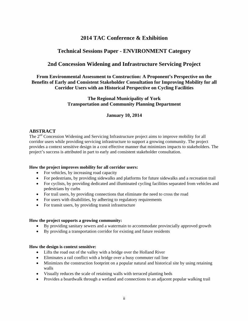
2014 TAC Conference & Exhibition
Technical Sessions Paper - ENVIRONMENT Category
2nd Concession Widening and Infrastructure Servicing Project
From Environmental Assessment to Construction: A Proponent’s Perspective on the
Benefits of Early and Consistent Stakeholder Consultation for Improving Mobility for all Corridor Users with an Historical Perspective on Cycling Facilities
The Regional Municipality of York
Transportation and Community Planning Department
January 10, 2014
ABSTRACT The 2nd Concession Widening and Servicing Infrastructure project aims to improve mobility for all corridor users while providing servicing infrastructure to support a growing community. The project provides a context sensitive design in a cost effective manner that minimizes impacts to stakeholders. The project’s success is attributed in part to early and consistent stakeholder consultation. How the project improves mobility for all corridor users:
For vehicles, by increasing road capacity For pedestrians, by providing sidewalks and platforms for future sidewalks and a recreation trail For cyclists, by providing dedicated and illuminated cycling facilities separated from vehicles and
pedestrians by curbs For trail users, by providing connections that eliminate the need to cross the road For users with disabilities, by adhering to regulatory requirements For transit users, by providing transit infrastructure
How the project supports a growing community:
By providing sanitary sewers and a watermain to accommodate provincially approved growth By providing a transportation corridor for existing and future residents
How the design is context sensitive:
Lifts the road out of the valley with a bridge over the Holland River Eliminates a rail conflict with a bridge over a busy commuter rail line Minimizes the construction footprint on a popular natural and historical site by using retaining
walls Visually reduces the scale of retaining walls with terraced planting beds Provides a boardwalk through a wetland and connections to an adjacent popular walking trail
iii
How the project is cost effective: Combines a needed road widening project with sewer and watermain works into one contract to
minimize the overall construction cost, duration and impacts to the local and travelling public by shortening the period of disruption by doing the work of two projects at the same time
How the project provided early and consistent stakeholder consultation: Proponent’s representatives (Project Manager, Design staff, Realty Services staff) and consultant
design team continuity throughout the environmental assessment, detailed design and construction phases
Meetings held before the start of the environmental assessment process with land owners adjacent to the corridor
Maintained communication tools, including phone logs and issues lists, throughout the duration of the project
Project Notes:
Arterial road length: 6 km, full reconstruction with bridges over rail and river, watermain, sanitary sewers and multiple forcemains. Construction cost $94 Million. Planning began in 2008, environmental assessment completed in 2012, project tendered in 2013 ahead of schedule and completion anticipated in 2016.
iv
Acknowledgements The Regional Municipality of York (York Region) would like to acknowledge the efforts of all who contributed to this project, particularly Martin Scott P.Eng. from MMM Group Limited, the consultant’s project manager during the environmental assessment and detailed design phases, and who also acts in an advisory role during construction. Numerous individuals contributed their time and energy during the planning and detailed design phases of the project; from MMM Group Limited: Mani Ruprai, Katherine Jim, Mike Murray, Dwayne West, Shannon Baker, Gillian Thompson, Rebecca Hay, Mark Cece; from the Lake Simcoe Region Conservation Authority: Brian Kemp, Kevin Kennedy, Christine Duchamp and Tom Hogenbirk; from Metrolinx: Jeff Bateman and Grant Bailey; from the Town of East Gwillimbury: Wayne Hunt, Don Allan, Carolyn Kellington, Dan Stone, Chris Cannon, Robin Prentice and Genvieve Singh; from the Town of Newmarket: Rick Bingham and Mark Kryzanowski; Glenn Pothier from GLPi; Jonathon Stefan from Stefan Management Consulting Inc.; from Hydro One: Shane Duego and Nicole Ireland; and from York Region: Steve Collins, Salim Alibhai, Brian Wolf, Shawn Dillon, Sean Love, Rob Bailey, David Lai, Tony Apreda, Claudio Micelli, Lauren Schipper, Dan Babensee, Bill Warner, Heather Babcock-Cormier, Richard Hui, Steve Murphy, Matthew Aylett, Michael Carnovale, Karen Sutcliffe, Gerard Sullivan, Carmen Hui, James McCague, Adam Barkovitz, Margaret Moniz, Jerry Paglia, Sheila Gallant, Eva Pulnicki, Joseph Petrungaro, Scott Stover, Tom MacPherson, Tushar Patel, Sean Woods, Nelson Costa, Carolyn Berryman, Lindsey Adlam, Lori Bowers, Saffron Davis, Yvonne Kaczor and Shawn Smith. The project team would also like to acknowledge York Region’s Senior Management Team for their support. Finally, a very special acknowledgement is made to the residents along the 2nd Concession corridor whose community has been altered by this project. In some instances, text and or figures from the 2nd Concession Environmental Study Report (MMM Group Ltd) and the Dufferin Street Environmental Study Report (URS Canada Inc.) have been reproduced in this paper. The author gratefully acknowledges the contributions provided by MMM Group Ltd. and URS Canada Inc.
Table of Contents 1) Synopsis .............................................................................................................................................. 2
2) Background and Motives ................................................................................................................ 2
3) Project Description .......................................................................................................................... 3
Existing Conditions ................................................................................................................................... 3
Future Conditions ...................................................................................................................................... 7
Partnerships ............................................................................................................................................... 8
4) Project Impacts ................................................................................................................................. 9
Improving mobility for all corridor users ................................................................................................. 9
Supporting a growing community ........................................................................................................... 10
Providing a context sensitive design ....................................................................................................... 10
Improving cost effectiveness .................................................................................................................. 10
Providing early stakeholder consultation ................................................................................................ 10
Providing consistent stakeholder consultation ........................................................................................ 10
5) Historical Perspective .................................................................................................................... 10
The Dufferin Street Environmental Assessment – an overview ............................................................. 10
The 2nd Concession and Dufferin Street projects – a comparison ......................................................... 11
6. Summary .......................................................................................................................................... 12
2
1) Synopsis
This paper provides a proponent’s perspective on the benefits of early and consistent stakeholder consultation in the planning of large transportation projects. This paper presents the details of a project that was “cradle to grave” in its delivery, from environmental assessment to construction. In the 2nd Concession Widening and Servicing Infrastructure project (2nd Concession project), the owner’s project manager and consultant’s project manager remained constant from planning through to construction. This paper provides a description of the 2nd Concession project, both the existing and future conditions and highlights how goals were met through early and consistent stakeholder involvement. This paper also provides an historical perspective on how cycling facility requirements have been addressed in the environmental assessments of large transportation projects, by comparing the 2nd Concession project with the Dufferin Street Environmental Assessment project initiated for York Region in 2004. The 2nd Concession project addresses current transportation and future servicing needs associated with provincially approved growth in the three communities of Holland Landing, Queensville and Sharon, all located in the Town of East Gwillimbury, in the northern portion of York Region. The project provides transportation capacity improvements for all modes of travel, as well as portions of the necessary servicing infrastructure to support planned growth in these three communities. The project was tendered ahead of schedule in 2013 and met its goal to start construction in early 2014, a goal set in late 2008 at the start of the environmental assessment planning phase. Construction is underway, with Aecon Construction and Materials Ltd. as the General Contractor, and with an anticipated completion date near the end of 2016. A location plan is provided at the end of this paper. The basic premise of this paper is that the earlier the consultation, the more time available to address stakeholder needs and create strong relationships; and the more consistent the consultation, the easier it is to address issues quickly since the history of the project is understood by all parties involved. In addition to the overall project goal of providing improved mobility for all corridor users including pedestrians, vehicles and cyclists, other benefits of early and consistent stakeholder consultation include reduced project costs and reduced schedule delays.
2) Background and Motives York Region typically spends more than $100 million per year reconstructing roads to accommodate growth. Depending on the project’s location within York Region, some of these road reconstruction projects can include sanitary sewers and watermains. The 2nd Concession project is one such project and includes road widening to four through lanes plus turning lanes, dedicated cycling facilities, multiple bridges and retaining walls, connections to existing trail systems, a gravity sewer, multiple forcemain sewers, a trunk watermain and the creation and restoration of wetlands. The motivating forces behind the 2nd Concession project are York Region’s Sustainability Principles, namely providing quality communities, an enhanced environment, infrastructure for a growing community and engaged communities.
3
This begins with planning for the future population and employment growth envisioned in the community plans for the Queensville, Sharon and Holland Landing communities in the Town of East Gwillimbury. The Region’s transportation and roadway management strategies have identified road network needs in the area of the 2nd Concession corridor between Green Lane and Queensville Sideroad, the southern and northern boundaries of these communities. York Region recognizes the opportunities this growth brings to promote non-motorized modes of transportation in the 2nd Concession corridor including sidewalks and cycling facilities. Other opportunities include the need to improve existing operating conditions which include:
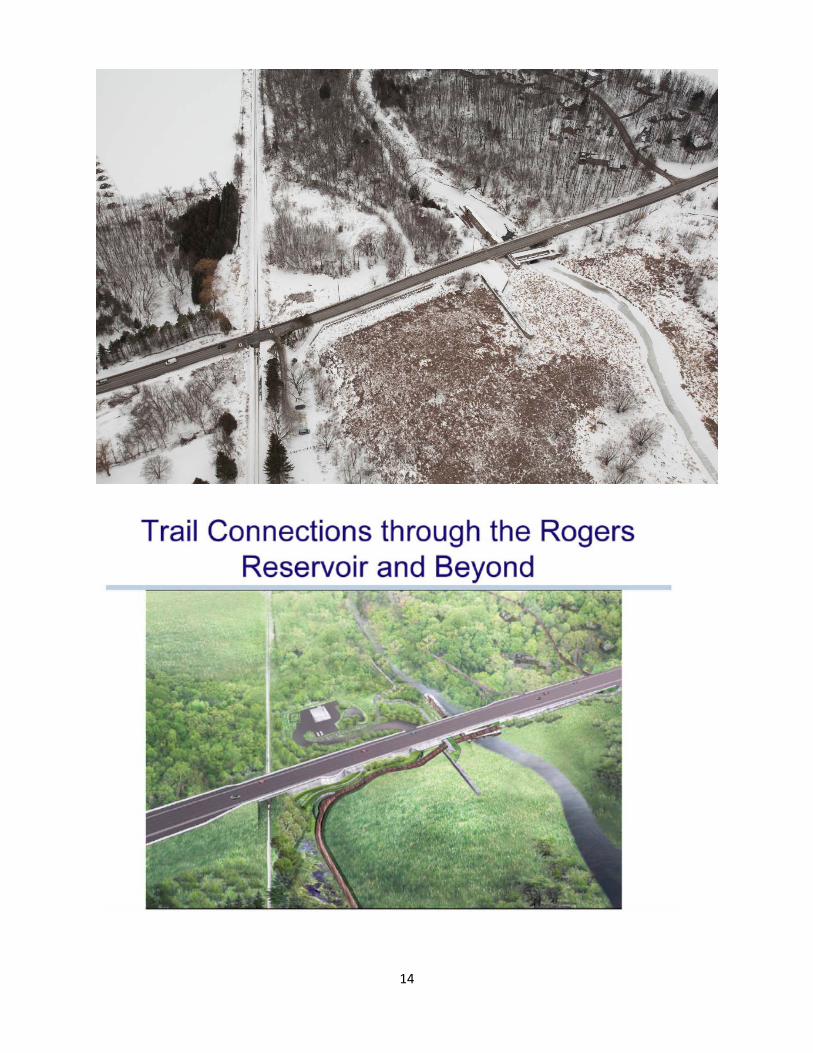
Steep hills and limited sight visibility An at-grade crossing at the GO railway tracks Preservation of the historic canal lock at Rogers Reservoir Access to Rogers Reservoir Connection to the adjacent Nokiidaa Trail
In response to these opportunities, as well as the planned growth in the Town of East Gwillimbury, an environmental assessment of the 2nd Concession corridor began in late 2008 and was completed in 2012. The study was conducted in accordance with Schedule ‘C’ of the Municipal Engineers Association Municipal Class Environmental Assessment (2007) process, which is approved under the Ontario Environmental Assessment Act. Early stakeholder engagement began with a "meet and greet" invitation to all property owners within the corridor on November 19, 2008. The early “meet and greet” was an opportunity for the local residents to become familiar with the project team. This made subsequent public meetings more effective as the stakeholders were already comfortable with the project team. This was followed by the first Public Consultation Centre meeting (PCC) on May 13, 2009. A second PCC was held on February 1, 2011. The environmental assessment wrapped-up with the Environmental Study Report which was filed on June 1, 2011 and a decision was received from the Ontario Ministry of the Environment (MOE) on June 6, 2012. Seven Part II Order requests were received by the MOE requesting the Region prepare a higher level individual environmental assessment, however one Part II Order request was rescinded and the remaining six were denied. Consistent stakeholder engagement was demonstrated throughout the environmental assessment (EA) as both the Region’s project manager (Mark Nykoluk) and the consultant’s project manager (Martin Scott) remained constant, not only through the EA, but through the detailed design and into construction. The relationships developed during the EA proved useful in addressing issues during detailed design, including property acquisition and utility relocation.
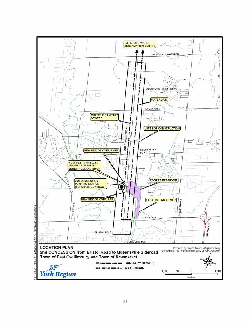
3) Project Description Existing Conditions Transferred from the Town of East Gwillimbury in September of 2006, the study area is the 2nd Concession, from south of Green Lane to Queensville Sideroad – a distance of approximately six kilometres. The existing 2nd Concession is a two-lane north-south road with a rural cross section, a 20 metre right-of-way and a posted speed of 60 to 70 km/h. There are two very steep hills, and at the bottom of one hill near Rogers Reservoir, there is an at-grade GO railway crossing carrying eight trains during the day, as well as three to four trains per week at roughly one o’clock in the morning. Aside from the steep hills and poor pavement condition, other influencing factors include tremendous population and employment growth approved to occur in the coming years.
4
The York Region Transportation Master Plan serves as the “blueprint” for all major transportation initiatives in the Region through to the year 2031. It is based on a “region wide” transportation model, which considers improvements across the Region, including the Bradford By-pass and Highway 404 Extension to Ravenshoe Road. However, even after considering planned improvements in other areas of the Region, including the Highway 404 extension and the inclusion of the Bradford By-pass, the modelling done as part of the Transportation Master Plan indicates additional north-south capacity is required to serve the increase in local population and employment in the area of the 2nd Concession by 2031. Based on the recommendations of the Transportation Master Plan, 2nd Concession was identified as a candidate for further investigation. This marked the initiation of the 2nd Concession EA. Other legislation directing municipalities on how and to what extent they are permitted to grow in this part of York Region includes the Oak Ridges Moraine Conservation Act, Greenbelt Act and Places to Grow Act. The Oak Ridges Moraine Conservation Plan protects the ecological (plants and animals) and hydrological (water) systems of the Oak Ridges Moraine Area. The authority comes from the Oak Ridges Moraine Conservation Act through the Ontario Ministry of Municipal Affairs and Housing. Although considered, this project does not lie within the Oak Ridges Moraine Conservation Area plan. The Greenbelt Plan protects environmentally sensitive land and farmlands in Ontario’s Golden Horseshoe area from urban development. The authority comes from the Greenbelt Act, again through the Ontario Ministry of Municipal Affairs and Housing. The west side of 2nd Concession, just south of Queensville Sideroad, is adjacent to the Greenbelt. Growth in York Region is informed through the “Growth Plan for the Greater Golden Horseshoe (2006). This legislation represents a planning “vision” for the Province of Ontario, recognizing planned and approved growth that will result in York Region’s population reaching 1.5 million residents by 2031 from the current estimate of just over 1.1 million. In addition to the Queensville Community Plan, there are two other approved Secondary Plans in the area, namely the Holland Landing and Sharon Community Plans. Population and employment adjacent to 2nd Concession are expected to dramatically increase as a result of these plans. Approved growth is 30,000 residents in Queensville, 9,200 residents in Sharon, and 16,000 residents in Holland Landing, representing an almost 400% increase from an existing population in these three communities of approximately 13,000. One important feature in the study area is the GO Transit Barrie Line currently crosses 2nd Concession at grade. The East Gwillimbury GO Station is located on the south side of Green Lane, east of 2nd Concession. In addition to transportation connectivity opportunities, the study team has also collected information on the socio-economic, cultural and natural environments. Within and adjacent to the study area is a rich social environment which includes the history of the lock system and the Rogers Reservoir, and the various trail systems in the area such as the Nokiidaa Trail and Tom Taylor Trail. Both provide access to the natural environment. Another important feature in the study area is the Rogers Reservoir Conservation Area which is located on the east side of 2nd Concession, north of Green Lane. It is a shallow reservoir and
5
marsh, frequented for bird watching, as well as hiking and cycling on the trail along the Holland River Trail. The 2nd Concession Environmental Study Report documented how lands in the 2nd Concession corridor became known as the Rogers Reservoir: The land that is now known as the Rogers Reservoir originally began as Crown Land which was divided into a series of three parcels of 200 acres each. Throughout the 1800’s these three lots were subdivided and sold to various land owners and used as farm land and the establishment of a grist and saw-mill. In the early 1900’s, construction began on the Holland River Diversion, a proposed extension of the Trent Canal system from Lake Simcoe to Aurora. A lack of water supply for the proposed lock system required the project engineers to construct reservoirs to retain the water from the spring freshets. The construction of the canal was cancelled after six years, leaving a series of unused locks and swing bridges along the Holland River between Newmarket and Holland Landing. In 1934, Russell Rogers and his wife, Jean, began acquiring the lands associated with the original parcels of Crown Land. For over 30 years, their land holdings grew and ultimately included the reservoir associated with the Holland River Diversion. In September of 1966, the Rogers’ granted part of their lands to Holland Valley Conservation Authority (which is now the Lake Simcoe Region Conservation Authority). Twenty-three years later, they transferred additional lands to the Lake Simcoe Region Conservation Authority. The lands, approximately 170 acres in size are now known as the Rogers Reservoir Conservation Area and provide a number of year-round recreational opportunities including hiking, skiing and bird watching. An important linkage in the regional trail network is the Nokiidaa Trail, which crosses the 2nd Concession at Rogers Reservoir. There are no provincially significant wetlands in the study area. There are three major wildlife habitat areas present, and there are also three watercourses present, one of which is the East Branch of the Holland River, and two minor tributaries. There are both warm and cold water aquatic species present, including rock and largemouth bass, chubs, shiners and suckers. However, the most important features in the study are the 56 properties adjacent to the 2nd Concession corridor from which lands were required. Lands adjacent to 2nd Concession within the study limits consist of rural residential properties. A traffic analysis indicated that 2nd Concession between Green Lane and Doane Road would need to accommodate four through lanes of traffic. Although York Region’s jurisdiction ends south of Green Lane at the municipal boundary with the Town of Newmarket, the project team continued to work with Town of Newmarket staff on the implications to the local road network south of Green Lane, determining the need to provide only two through lanes of traffic. Given the existing and future traffic projections, combined with the incredible natural features in the study area, a two-fold problem/opportunity statement was adopted: first, is the opportunity to plan ahead, with the infrastructure needed to support this growth in population and employment – the “richly imagined future”; and second: to use this opportunity to improve the human interface with the natural environment, including the Holland River, Rogers Reservoir and Nokiidaa Trail system. As noted in the Environmental Study Report is the problem opportunity statement: The Regional Municipality of York is addressing the existing and future transportation needs for 2nd
6
Concession Road between Green Lane and Queensville Sideroad accounting for future land use in the Queensville, Sharon and Holland Landing communities while improving roadway operating conditions in the corridor. In addition, the Region is incorporating opportunities to encourage non-motorized modes of transportation and to promote recreational activities in the area such as the Nokiidaa Trail and the Rogers Reservoir Conservation Area. Rogers Reservoir was identified as a significant feature during the environmental assessment, requiring additional design consideration. The section of 2nd Concession between the GO railway line and Rogers Reservoir received significant attention during the environmental assessment, with many residents referring to the Rogers Reservoir location as a “diamond in the rough”. Local public interest in this area was also identified in surveys conducted by the Lake Simcoe Region Conservation Authority, which found that the Rogers Reservoir receives nearly 30,000 visitors per year, with nearly 80 per cent of these visitors coming from the local area (i.e., within a ten kilometre radius). The Region committed to developing a Context Sensitive Design for 2nd Concession through the Rogers Reservoir. In response to what was heard from the public, the following commitments were made during the environmental assessment:
To provide cycling facilities and adequate space for municipal sidewalks which facilitate access to Rogers Reservoir from the north and south along the 2nd Concession
To minimize pedestrian/road/rail conflicts and improve operating conditions by grade separating 2nd Concession from the Rogers Reservoir with bridges over the GO rail line and Holland River
To provide connectivity to the Nokiidaa Trail to the east and west of Rogers Reservoir To apply a context sensitive design to the retaining walls along the east side of 2nd
Concession at Rogers Reservoir, for approximately 120 metres, to enable the grade separation of the 2nd Concession over the Holland River and the GO rail line
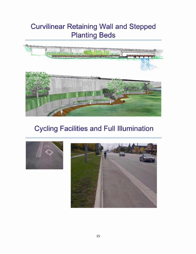
In confirming the need for a context sensitive design of the retaining walls and its added value, the project team considered the increased capital cost to the project (approximately one percent) as well as the long-term maintenance and rehabilitation costs of the asset. The environmental assessment recommended widening 2nd Concession to four lanes between Green Lane and Doane Road, including bridges over the rail corridor and the Holland River, cycling facilities, and a context sensitive treatment for anew retaining walls through the Rogers Reservoir. Specific works include:
A widening of 2nd Concession from two to four lanes between Bristol Road and Doane Road
Regional servicing including a watermain and sewers Replacement of the existing bridge over the Holland River A new bridge to carry 2nd Concession over the GO rail line Geometric improvements to upgrade 2nd Concession to Regional standards Cycling facilities
The project also includes a significant servicing component including a gravity sewer, sanitary forcemains and a watermain. Related documents and projects include:
The Regional Municipality of York Official Plan (2009) York Region Transportation Master Plan (2009) York Region Pedestrian and Cycling master Plan (2008) York Durham Sewage System Project (YDSS)
7
Future Conditions As noted earlier, the 2nd Concession project includes road, bridge, linear (trunk sewer and watermain), and landscaping works. Road works include site preparation, excavation, asphalt paving, gravelling, grading, concrete curb and gutters, storm sewers, drainage work, illumination, traffic signals, pavement markings, protection of environmental features, and related works. The reconstructed 2nd Concession will be four lanes with one direction cycle paths on each side of the road, and graded boulevards for future sidewalks. Bridge works include the construction of three new bridges, retained soil system (RSS) and concrete cast-in-place walls, concrete culvert headwalls and bridge removals. The 2nd Concession Bridge over Newmarket Subdivision rail line (at Mileage 36.38) is a precast concrete girder structure with a 19.2 m span. The 2nd Concession bridge over the Holland River will be a steel bathtub girder structure with a 57.5 m span. Both 2nd Concession bridges will include linear works attached to the underside of the bridge. The Nokiidaa Trail pedestrian bridge will be a four span pre-stressed concrete beam bridge with an overall span of 36.6 m. The bridges to be removed include the existing roadway bridge over the Holland River and the original bridge which sits upon the Rogers Reservoir weir. Included in the bridge design was an architectural treatment of parapet walls, pilasters and lighting. This architectural approach is being included in the bridge design in an effort to humanize the scale of the bridge, and to also suit pedestrians and cyclists. This is clearly reflected in the detailed insets of the parapet walls, addition of pilasters, and coordinated decorative lighting to reduce the visual span of the bridge. The Linear Works include the construction of the watermains, forcemains and gravity sanitary sewers. The proposed linear works extend from Green Lane northerly to approximately 73 m north of the Queensville Pumping Station (north limit of construction). The works consist of:
Watermain - 400 mm diameter watermain from Green Lane to the Queensville Pumping Station, including all valve chambers and appurtenances
Sanitary Forcemains – twin 762 mm forcemains from 2nd Concession Pumping Station to the north limit of construction, including all chambers and appurtenances. These forcemains will travel through a 2,000 mm diameter tunnel that is to be constructed north of Doane Road. The overall length of the twin forcemains is 4,500 metres and the tunnel section is 320 metres
Sanitary Forcemains – three 373 mm diameter forcemains from approximately 110 m north of Doane Road to the north limit of construction, including all chambers and appurtenances. These forcemains will also travel through the 2000 mm diameter tunnel. The overall length of this section is approximately 1,368 metres
Sanitary Forcemains – twin 293 mm diameter forcemains from the 2nd Concession Pumping Station to approximately 110 m north of Doane Road, including all chambers and appurtenances. The overall length of these forcemains is 3,132 metres
Sanitary Forcemains – one 293 mm diameter forcemain and one 410 mm diameter forcemain from the 2nd Concession Pumping Station to Green Lane, including all chambers and appurtenances. The overall length of these forcemains is 1,120 metres
Sanitary Gravity Sewer – 900 mm diameter sanitary sewer from Green Lane to the 2nd Concession Pumping Station, including all maintenance holes and connection stubs. This
8
sewer construction will include approximately 640 m of micro-tunnelling. The overall length of the sewer is approximately 1,050 metres
Sanitary Gravity Sewer – 450 mm to 600 mm diameter sanitary sewer from approximately 110 m north of Doane Road to the 2nd Concession Pumping Station, including all maintenance holes and connection stubs. The overall length of the sewer is approximately 3,132 metres
Landscaping Works include all the plantings and works within the environmentally sensitive Rogers Reservoir. The landscaping work includes all of the plantings, the construction of a boardwalk and the creation of new wetland areas. Scheduling was paramount in delivering this project to meet an ultimate in-place and commissioned servicing requirement date of May 1, 2015. In order to meet the following operational constraints, every effort was made during the planning and design to keep the project on schedule:
A sanitary forcemain extending from Green Lane to the proposed pumping station at Rogers Reservoir must be commissioned and operational by April 1, 2015.
The gravity sewer from Doane Road to the Rogers Reservoir Pumping Station must be commissioned and operational by April 1, 2015.
The watermain from Mount Albert Road to Hillcrest Drive must be commissioned and operational by May 1, 2015.
When the environmental assessment began in late 2008, the target for a start of construction was identified in the Region’s 10 Year Roads Construction Program to start in 2014. This goal was achieved with the tendering of the project on December 20, 2013, ahead of schedule. Partnerships Partnerships were created at the very beginning of the planning phase. Local residents, the Town of East Gwillimbury, the Lake Simcoe Region Conservation Authority, the Town of Newmarket, Metrolinx, the development community and utility companies were all actively involved stakeholders throughout this project. Property owners directly adjacent to 2nd Concession within the study limits were invited to attend a “meet and greet” session on November 19, 2008. This invitation, along with a copy of the Notice of Study Commencement were hand delivered to adjacent property owners; the turnout was large and included almost every adjacent owner. The purpose of the “meet and greet” was to introduce the study and to provide an opportunity for adjacent property owners and residents to meet the project team and discuss key issues related to the study. The “meet and greet” was held as an open house with an introduction by the Region. During the open house those who attended could review display panels and discuss the study with staff from York Region and consultants. A large aerial map was made available, and residents identified key features of their properties, noting their concerns with and visions for the 2nd Concession corridor. This first meeting helped establish long-term relationships that then grew through the planning and design phases. Valuable information was collected on existing conditions including the location of wells and septic beds. An issues log was created, along with a binder containing a map and spreadsheet to record comments. This binder was a valuable tool to note phone conversations and to maintain a record of communications, ensuring residents received customized service when dealing with York Region staff.
9
A Technical Advisory Committee was created and included the Towns of East Gwillimbury and Newmarket, utility companies and special interest groups. Goals and objectives were noted and identified early on in the process and resulted in early team buy-in. One example was the need to provide a critical piece of infrastructure: a gravity sewer component needed to be operational by April 2015 in order to meet future servicing requirements. The early identification of this requirement allowed the Region to accommodate the Town of East Gwillimbury’s request to coordinate all of the 2nd Concession works to minimize public impact. Property acquisition is typically a critical component of any transportation related work. The 2nd Concession Project was no exception. The Region’s Realty Services staff attended all Public open houses during the EA, including individual meetings with property owners in advance of second Public meetings where the recommended alternative including property impacts was presented. The same Realty Services staff worked with property owners during the detailed design phase. This early and consistent involvement resulted in only one hearing of necessity request, which was subsequently rescinded. Property acquisition proceeded smoothly and in time for utilities to be relocated in advance of construction. Regional staff also remained largely consistent during the planning and design phases which is not always possible on large projects. This resulted in a synergy which in turn resulted in a design “first” for York Region, namely on-street cycle facilities separated from both vehicles and pedestrians by curbs. Operations staff were involved in the design to ensure maintenance activities including snow removal were feasible. Utility company representatives also attended all public open house meetings, and their representatives also remained constant throughout the planning and detailed design phases. Strong, crucial relationships were developed between Region, utility and consultant staff. The local conservation authority staff also remained consistent during the planning and design phases. This ensured that commitments made in the EA were met during design and construction, including for instance, a high degree of trail connectivity. The most recent partner to join the team was Aecon Construction and Materials Limited, the contractor who was awarded the project on March 20, 2014.
4) Project Impacts Improving mobility for all corridor users The project improves mobility:
For vehicles, by increasing road capacity For pedestrians, by providing sidewalks and platforms for future sidewalks For cyclists, by providing dedicated and illuminated cycling facilities separated from
vehicles and pedestrians by curbs For trail users, by providing connections that eliminate the need to cross the road For users with disabilities, by adhering to regulatory requirements For transit users, by providing transit infrastructure

10
Supporting a growing community York Region is accommodating provincially approved development growth by including sanitary sewers and a watermain in this project.
Providing a context sensitive design The project has been designed in a context sensitive manner by lifting the road out of the valley with a bridge over the Holland River. The project eliminates a rail conflict with a bridge over a busy commuter rail line and minimizes the construction footprint on a popular natural and historical site with retaining walls. The project’s design hides retaining walls with terraced planting beds and provides a boardwalk through a wetland and connections to an adjacent popular walking trail. To minimize the costs of a long bridge, the crossing was designed to include a fill section supported by retaining walls on one side, with a bridge at either end: one bridge over the rail tracks and one bridge over the East Branch of the Holland River. This grade separation eliminates conflicts between trains and road vehicles and also “lifts” the road out of the valley to minimize disturbance to the surrounding landscape. The retaining walls, however are long, approximately 200m in length, and to minimize the large expanse of concrete face, a context sensitive design has been provided. The planning work envisioned a trellis system which would support the growth of hardy, drought tolerant vines on the face of the walls, with cable systems arranged in a pattern to allow the vines to climb along the wall face. As detailed design progressed, this trellis system was replaced with a series of terraced planting beds, still supporting hardy, drought tolerant plant species for ease of maintenance. Improving cost effectiveness The project combines a needed road widening project with sewer and watermain works into one contract to minimize the overall construction cost, duration and impacts to the travelling public, resulting in substantial overall cost efficiencies. Providing early stakeholder consultation The “meet and greet” was the first point of contact between the proponent and the adjacent landowners, and although not mandated, proved extremely beneficial. Providing consistent stakeholder consultation As early as the first public information centre, Realty Services staff were on hand to discuss the land acquisition process. Proponent’s representatives (project manager, design staff, Realty Services staff) and design team (consultant) continuity throughout the environmental assessment, detailed design and construction phases. Prior to the environmental assessment, meetings were held with land owners adjacent to the corridor. Communication tools, including phone logs and issues lists, were maintained throughout the duration of the project.
5) Historical Perspective The Dufferin Street Environmental Assessment – an overview York Region has been growing for years, from over 166,000 residents in 1971 to 905,000 in 2005, to over 1,100,000 in 2013. Dufferin Street forms a major north-south transportation corridor, situated in the central part of the City of Vaughan’s urban area and provides a connecting link between York Region and the City of Toronto for transit and vehicular use. In

11
2004, Dufferin Street was a four-lane urban roadway with additional turning lanes at intersections. With significant development expected in York Region, transportation demand in the corridor was also expected to increase. In response to this expected increase, the purpose of the project was to ensure sufficient transportation capacity was provided for future volumes and satisfactory level of service maintained. The Dufferin Street EA was conducted according to the procedure outlined for Schedule “C” projects within the Municipal Engineers Association Municipal Class Environmental Assessment process. The consultant’s project manager for the Dufferin Street Environmental Assessment was the author of this paper. In 2005, York Region had recently completed the “Towards Great Regional Streets – A Path to Improvement” study, which was undertaken in order to define guidelines for new six lane roadways within York Region. Regional policy envisioned multipurpose streescaped streets that are pedestrian friendly and interface with adjacent users, supporting multiple transportation modes and streetscaped with attractive medians and boulevards to reflect the character of the community. The preferred solution for the Dufferin Street corridor included six through lanes, curb high occupancy vehicle (HOV) lanes, a raised median and 1.5 m on-street bike lanes. The 2nd Concession and Dufferin Street projects – a comparison There are many similarities between the Dufferin Street EA project and the 2nd Concession project. Similar to 2nd Concession, Dufferin Street is a major north-south transportation corridor. Dufferin Street is situated in the central part of the City of Vaughan’s urban area and provides a connecting link between York Region and the City of Toronto for transit and vehicular use, whereas 2nd Concession is located in a rural setting, which over time, will evolve to become the major spine connecting Holland Landing, Sharon and Queensville. Prior to improvements, Dufferin Street was a four-lane urban roadway with additional turning lanes at intersections. South of Steeles Avenue West, Dufferin Street is a four-lane arterial under the jurisdiction of the City of Toronto. A rail authority was involved in both projects, as well as a local conservation authority. The differences lie in how the cycling facilities were developed. The Dufferin Street design resulted in one of the first constructed on-street bike lanes in York Region. It was near the end of the environmental assessment phase where the design adopted a 1.5 metre wide on-street bike lane adjacent to the curb, without any buffer between the bike lane and the adjacent HOV lane. This was the treatment in 2005, when York Region was just beginning to consider implementing cycling facilities. When the Dufferin Street Environmental Study Report was written and a draft was distributed, the on-street bike lanes were not included. Following an internal review of the draft Environmental Study Report (ESR), a re-design occurred and inclusion of an additional chapter in the ESR documented the provision of the on-street bike lanes. The Dufferin Street on-street bike lanes, a first for York Region, shares a similarity with the 2nd Concession project which is also a first for York Region: the provision of fully separated cycling facilities, separated from traffic and pedestrians by curbs, which was considered and developed early in the design process. The 2nd Concession project will provide a 2m wide cycle facility on both sides of the road, separated from vehicles by a 0.5 mountable curb, and from the boulevard with a 0.5 barrier curb.
12
6. Summary The 2nd Concession project is one of the largest capital projects undertaken by the Regional Municipality of York. The success of the 2nd Concession project was the early “buy-in” from stakeholders and local residents that has allowed the project to be completed (and constructed) within eight years from the start of the environmental assessment process. The success is two-fold: projects that do not have early “buy-in“ often extend over many years as stakeholders “drag-out” the process for as long as possible, requiring additional time and effort to resolve issues; with the early identification of enhancements and commitments performed as part of the 2nd Concession project, this time was significantly shortened, resulting in saved tax dollars. In addition, the Region was able to proceed with the construction of infrastructure that is needed to support planned development.
13
14
15