Embed Size (px)
Citation preview
Volume 7, Number 2 Summer 2003
Andrew J. SpanoCounty Executive
Dr. Norman J. JacknisChief Information Officer
Sam WearGIS Manager
Department of Information TechnologyGeographic Information Systems
GG
II
SS
EEEE OOOO GGGG RRRR AAAA PPPP HHHH IIII CCCC
NNNN FFFF OOOO RRRR MMMM AAAA TTTT IIII OOOO NNNN
YYYY SSSS TTTT EEEE MMMM SSSS
2nd 2nd Annual Annual WWestchester GIS Symposium Draws Crowestchester GIS Symposium Draws CrowddUser presentat ions and exhibi tors highl ight day-long event
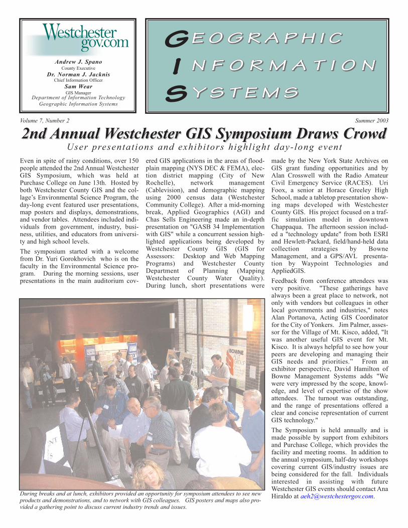
Even in spite of rainy conditions, over 150people attended the 2nd Annual WestchesterGIS Symposium, which was held atPurchase College on June 13th. Hosted byboth Westchester County GIS and the col-lage’s Environmental Science Program, theday-long event featured user presentations,map posters and displays, demonstrations,and vendor tables. Attendees included indi-viduals from government, industry, busi-ness, utilities, and educators from universi-ty and high school levels.The symposium started with a welcomefrom Dr. Yuri Gorokhovich who is on thefaculty in the Environmental Science pro-gram. During the morning sessions, userpresentations in the main auditorium cov-
ered GIS applications in the areas of flood-plain mapping (NYS DEC & FEMA), elec-tion district mapping (City of NewRochelle), network management(Cablevision), and demographic mappingusing 2000 census data (WestchesterCommunity College). After a mid-morningbreak, Applied Geographics (AGI) andChas Sells Engineering made an in-depthpresentation on "GASB 34 Implementationwith GIS" while a concurrent session high-lighted applications being developed byWestchester County GIS (GIS forAssessors: Desktop and Web MappingPrograms) and Westchester CountyDepartment of Planning (MappingWestchester County Water Quality).During lunch, short presentations were
made by the New York State Archives onGIS grant funding opportunities and byAlan Crosswell with the Radio AmateurCivil Emergency Service (RACES). UriFoox, a senior at Horace Greeley HighSchool, made a tabletop presentation show-ing maps developed with WestchesterCounty GIS. His project focused on a traf-fic simulation model in downtownChappaqua. The afternoon session includ-ed a "technology update" from both ESRIand Hewlett-Packard, field/hand-held datacollection strategies by BowneManagement, and a GPS/AVL presenta-tion by Waypoint Technologies andAppliedGIS.Feedback from conference attendees wasvery positive. "These gatherings havealways been a great place to network, notonly with vendors but colleagues in otherlocal governments and industries," notesAlan Portanova, Acting GIS Coordinatorfor the City of Yonkers. Jim Palmer, asses-sor for the Village of Mt. Kisco, added, "Itwas another useful GIS event for Mt.Kisco. It is always helpful to see how yourpeers are developing and managing theirGIS needs and priorities.” From anexhibitor perspective, David Hamilton ofBowne Management Systems adds "Wewere very impressed by the scope, knowl-edge, and level of expertise of the showattendees. The turnout was outstanding,and the range of presentations offered aclear and concise representation of currentGIS technology." The Symposium is held annually and ismade possible by support from exhibitorsand Purchase College, which provides thefacility and meeting rooms. In addition tothe annual symposium, half-day workshopscovering current GIS/industry issues arebeing considered for the fall. Individualsinterested in assisting with futureWestchester GIS events should contact AnaHiraldo at [email protected] breaks and at lunch, exhibitors provided an opportunity for symposium attendees to see new
products and demonstrations, and to network with GIS colleagues. GIS posters and maps also pro-vided a gathering point to discuss current industry trends and issues.
2
NYS GIS/LIS NYS GIS/LIS AssociationAssociationAn initiative is currently underway to cre-ate a professional organization for GISprofessionals in New York State. Thoughmany other states throughout the countryhave similar associations which promoteGIS professional development issues, nosingle independent organization currentlyexists in New York State. It is anticipatedthe association, which would encompassGIS professionals in government, busi-ness, industry, academia/education, andutilities, would also work closely withother professional societies and organiza-tions and augment the NYS CoordinatingProgram currently administered throughthe NYS Office for Cyber Security andCritical Infrastructure Coordination. NYSChapter affiliations with other nationalorganizations such as GITA and URISAare also under consideration. An on-linesurvey form, which is being posted at theSpatial Information Technology Center atthe Fulton-Montgomery CommunityCollege website, has been developed togather feedback and comments from theNYS GIS community on the potential offorming such an organization. The surveyform can be accessed athttp://www.sitc.cc/Survey.htm. For moreinformation on the NYS GIS/LISAssociation initiative, contact Sam Wearat [email protected].
GIS EventGIS EventssNEARCNEARCThe Northeast ARC/INFO Users Group(NEARC) will hold its 18th annual confer-ence at the Goat Island Hyatt Hotel,Newport, Rhode Island, November 2-5,2003. With the theme "Users HelpingUsers," the conference will featurekeynote sessions, vendor demonstrations,poster displays, workshops and user pre-sentations. For more information and reg-istration visit the conference website athttp://www.northeastarc.org.
NYS GIS Conference NYS GIS Conference The 19th Annual New York State GISConference will be held at the Holiday InnTurf in Albany from October 2nd to the 3rd,2003. With "Essential for the ModernWorld" as this year's theme, the confer-ence will showcase GIS projects through-out the state at all levels of government,industry, and academia. A wide range ofpaper presentations is scheduled, includ-ing poster sessions, and pre-conferenceworkshops. Leading industry vendorswill also be presenting GIS hardware andsoftware-related products, as well as pro-fessional services. For more informationand registration, visit the conference web-site at http://www.esf.edu/nysgis/2002.htm.
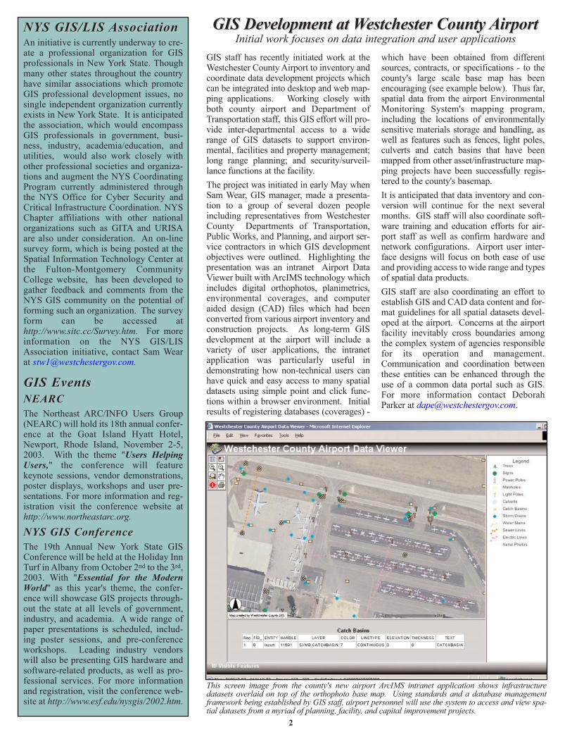
GIS staff has recently initiated work at theWestchester County Airport to inventory andcoordinate data development projects whichcan be integrated into desktop and web map-ping applications. Working closely withboth county airport and Department ofTransportation staff, this GIS effort will pro-vide inter-departmental access to a widerange of GIS datasets to support environ-mental, facilities and property management;long range planning; and security/surveil-lance functions at the facility.The project was initiated in early May whenSam Wear, GIS manager, made a presenta-tion to a group of several dozen peopleincluding representatives from WestchesterCounty Departments of Transportation,Public Works, and Planning, and airport ser-vice contractors in which GIS developmentobjectives were outlined. Highlighting thepresentation was an intranet Airport DataViewer built with ArcIMS technology whichincludes digital orthophotos, planimetrics,environmental coverages, and computeraided design (CAD) files which had beenconverted from various airport inventory andconstruction projects. As long-term GISdevelopment at the airport will include avariety of user applications, the intranetapplication was particularly useful indemonstrating how non-technical users canhave quick and easy access to many spatialdatasets using simple point and click func-tions within a browser environment. Initialresults of registering databases (coverages) -
which have been obtained from differentsources, contracts, or specifications - to thecounty's large scale base map has beenencouraging (see example below). Thus far,spatial data from the airport EnvironmentalMonitoring System's mapping program,including the locations of environmentallysensitive materials storage and handling, aswell as features such as fences, light poles,culverts and catch basins that have beenmapped from other asset/infrastructure map-ping projects have been successfully regis-tered to the county's basemap. It is anticipated that data inventory and con-version will continue for the next severalmonths. GIS staff will also coordinate soft-ware training and education efforts for air-port staff as well as confirm hardware andnetwork configurations. Airport user inter-face designs will focus on both ease of useand providing access to wide range and typesof spatial data products. GIS staff are also coordinating an effort toestablish GIS and CAD data content and for-mat guidelines for all spatial datasets devel-oped at the airport. Concerns at the airportfacility inevitably cross boundaries amongthe complex system of agencies responsiblefor its operation and management.Communication and coordination betweenthese entities can be enhanced through theuse of a common data portal such as GIS.For more information contact DeborahParker at [email protected].
GIS Development at GIS Development at WWestchester County estchester County AirportAirportInitial work focuses on data integration and user applications
This screen image from the county's new airport ArcIMS intranet application shows infrastructuredatasets overlaid on top of the orthophoto base map. Using standards and a database managementframework being established by GIS staff, airport personnel will use the system to access and view spa-tial datasets from a myriad of planning, facility, and capital improvement projects.
GIS Day 2003GIS Day 2003Westchester County GIS will hold its 2ndGIS Day event on November 20, 2003.County GIS staff anticipate holding theevent in the main lobby of the CountyOffice Building, 148 Martine Avenue, indowntown White Plains. Designed tointroduce the general public to GeographicInformation Systems (GIS) technology,Westchester County GIS users will displaymaps illustrating recent and on-going pro-jects, hold demonstrations, distribute hand-outs and pamphlets, and highlight otherGIS applications throughout the county inboth local government, academia and busi-ness. Individuals or agencies interested inparticipating in the GIS Day event, contactAna Hiraldo at [email protected] visit our website http://giswww.westch-estergov.com for updates.
GIS DatGIS Data Sharing IMAsa Sharing IMAsCounty GIS staff continue to share and dis-tribute base map datasets to local govern-ments under the terms of the GIS DataSharing Inter-Municipal Agreement (IMA).Under the terms of this agreement, thecounty provides both digital orthophotogra-phy and planimetric coverages from theSpring 2000 countywide base mapping pro-ject to the municipality in exchange for GISdatabases which are being developed local-ly. This data sharing formula provides a“win-win” situation for both governmentsin terms of eliminating costly spatial dataduplication efforts. A database design doc-ument is also included with the 100'-scaledatasets that the county makes available tothe municipality. To date, twelve munici-palities have entered into the GIS DataSharing IMA including Mt. Vernon,Yonkers, Larchmont, Mt. Kisco,Pleasantville, Bedford, Cortlandt,Lewisboro, Ossining, North Castle, NorthSalem, and Yorktown. For more informa-tion contact Sam Wear at [email protected].
Customized Mapping Services Customized Mapping Services As staff resources permit, WestchesterCounty GIS provides customized mappingservices to individuals and agencies on afirst-come, first-serve basis. Fees for map-ping services are based on the amount ofGIS staff time required fulfill the request.A minimum of three hours is charged forany specific mapping request, with materi-als and shipping extra. Due to public safe-ty issues, digital orthophotography or map-ping cannot be provided in designated"sensitive" or "high security" areas of thecounty. Information on customized map-ping services and/or data requests, costs,and related services can be obtained fromCindy Louie at [email protected].
3
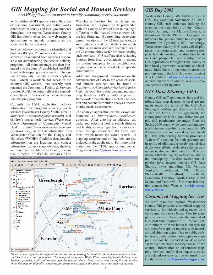
GIS Mapping for Social and Human ServicesGIS Mapping for Social and Human ServicesArcIMS application expanded to identify community service locations
With traditional GIS applications in the areasof planning, assessment, and public worksestablished in county and local governmentsthroughout the region, Westchester CountyGIS has slowly expanded its web mappingapplications to include programs in thesocial and human services. Service delivery locations are identified andbuilt as GIS "point" coverages derived fromaddress files obtained from agencies respon-sible for administering the service deliveryprograms. All point coverages are then inte-grated into the county's established ArcIMS-based web mapping environment. The on-line Community Facility Locator applica-tion, which is available for access at thecounty's GIS website, has recently beenrenamed the Community Facility & ServicesLocator (CFSL) to better reflect the expand-ed emphasis on "services" in the county's on-line mapping program.Currently the CSFL application includesinformation for programs covering youthservices (Westchester County Youth Bureau /http://www.westchestergov.com/youth) andchildren's mental health services (WestchesterCounty Department of Community MentalHealth / http://www.westchestercommuni-tynetwork.com), as well as information fromWestchester Coalition for the Hungry andHomeless (WCHH). Coalition data containsinformation on the locations and contactinformation for area soup kitchens, shelters,and food pantries. Ms. Rosa Boone, execu-tive director, of WCHH, explains "The
Westchester Coalition for the Hungry andHomeless, Inc. is proud of its partnershipwith the County of Westchester in making adifference in the lives of those citizens whoare less fortunate. By providing up-to-date,current locations of the 72 food pantries, 38soup kitchens and 33 shelters under itsumbrella, we make access to such families inthe 24 communities easier for those needingsuch services.” GIS staff are also reviewinginquires from local governments to expandthe on-line mapping to list neighborhoodprograms which serve residents in specificcommunities.Additional background information on theadvancements of GIS in the areas of socialand human services can be found athttp://www.esri.com/industries/health/index.html. Beyond basic data viewing and map-ping functions, GIS provides a powerfulframework for applications such as site loca-tion and patient distribution analysis or com-munity needs assessments. The county's application can be viewed andlaunched at http://giswww.westchester-gov.com. After entering an address, zipcode, and selecting both a search distanceand facility/services type from a pull-downmenu, the application will list those loca-tions which match the search criteria. Amapping template and on-line help are alsoincluded in the application. For more infor-mation on the CFSL application, contactTong Zhou at [email protected].
Social service agencies throughout the county can increasing be located with the Community Facilitiesand Services Locator application. This image of the greater White Plains area highlights shelters, soupkitchens, pantries, and youth service agencies among others. Users can extend the application to alsoshow the location of public transportation components such as bus lines, bus stops, and rail systems.
4
DEPARTMENT OF INFORMATION TECHNOLOGY908 Michaelian Office Building148 Martine AvenueWhite Plains, NY 10601
Articles and graphics in this newsletter prepared by: Xiaobo Cui, Ana Hiraldo, Cindy Louie, Deborah Parker, Ariane Porter, Sam Wear, Viola Wilson, and Tong Zhou.
http://www.westchestergov.comWestchester County GEOGRAPHIC INFORMATION SYSTEMS
is published by the Westchester County Department of Information Technology
Andrew J. Spano, County Executive Dr. Norm J. Jacknis, Chief Information Officer
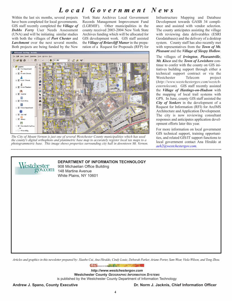
L o c a l G o v e r n m e n t N e w sL o c a l G o v e r n m e n t N e w sWithin the last six months, several projectshave been completed for local governments.GIS staff recently completed the Village ofDobbs Ferry User Needs Assessment(UNA) and will be initiating similar studieswith both the villages of Port Chester andLarchmont over the next several months.Both projects are being funded by the New
York State Archives Local GovernmentRecords Management Improvement Fund(LGRMIF). Other municipalities in thecounty received 2003-2004 New York StateArchives funding which will be allocated forGIS development work. GIS staff assistedthe Village of Briarcliff Manor in the prepa-ration of a Request for Proposals (RFP) for
Infrastructure Mapping and DatabaseDevelopment towards GASB 34 compli-ance and assisted with vendor selection.The county anticipates assisting the villagewith reviewing data deliverables (ESRIGeodatabases) and the delivery of a desktopsystem. County staff has also recently metwith representatives from the Town of Mt.Pleasant and the Village of Sleepy Hollow.The villages of Irvington, Pleasantville,Mt. Kisco and the Town of Lewisboro con-tinue to confer with the county on GIS ini-tiatives building support through either atechnical support contract or via theWestchester Telecom project(http://www.westchestergov.com/westch-estertelecom). GIS staff recently assistedthe Village of Hastings-on-Hudson withthe mapping of local trail systems withGPS. In June, county GIS staff assisted theCity of Yonkers in the development of aRequest for Information (RFI) for ArcIMSArchitecture and Application Development.The city is now reviewing consultantresponses and anticipates application devel-opment efforts later this year. For more information on local governmentGIS technical support, training opportuni-ties, and related GIS/IT support functions tolocal government contact Ana Hiraldo [email protected].
The City of Mount Vernon is just one of several Westchester County municipalities which has usedthe county's digital orthophoto and planimetric base map to accurately register local tax maps to aphotogrammetric base. This image shows properties surrounding city hall in downtown Mt. Vernon.