Embed Size (px)
Citation preview
28-1
28. ENVIRONMENTAL CONDITIONS
28. 1 Environmental Characteristics of the Project Sites
28.1.1 Geomorphology of Mahakam River Basin
Borneo is the third largest island in the world (after Greenland and New Guinea). Borneo lies in a region of constant rainfall and of high temperatures throughout the year, which are ideal condition for fauna and flora.
Mahakam River is the third longest river in Indonesia (after Kapuas 1,143km, Barito 900km, and Mahakam 775km). It flows from the mountainous interior of the island to the east coast.
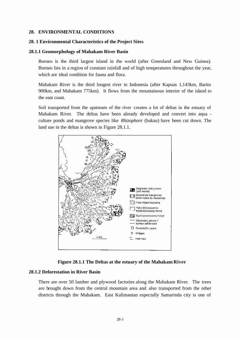
Soil transported from the upstream of the river creates a lot of deltas in the estuary of Mahakam River. The deltas have been already developed and convert into aqua - culture ponds and mangrove species like Rhizophore (bakau) have been cut down. The land use in the deltas is shown in Figure 28.1.1.
Figure 28.1.1 The Deltas at the estuary of the Mahakam River
28.1.2 Deforestation in River Basin
There are over 50 lumber and plywood factories along the Mahakam River. The trees are brought down from the central mountain area and also transported from the other districts through the Mahakam. East Kalimantan especially Samarinda city is one of
28-2
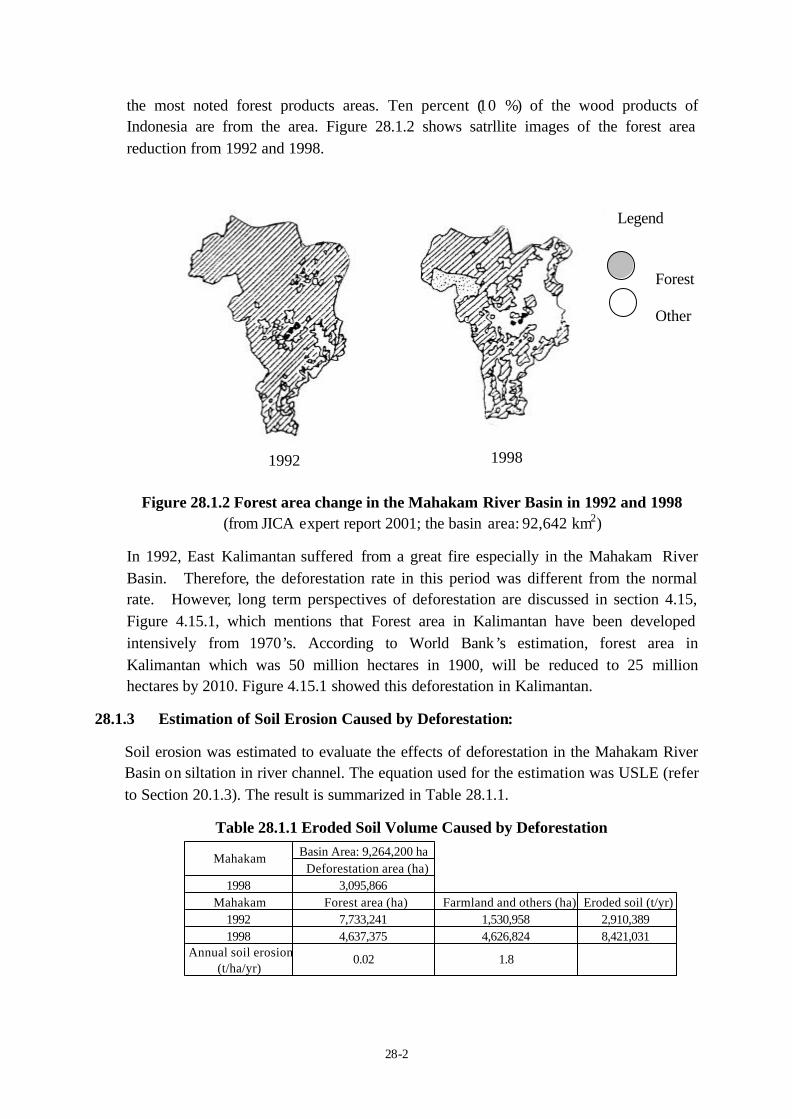
the most noted forest products areas. Ten percent (10 %) of the wood products of Indonesia are from the area. Figure 28.1.2 shows satrllite images of the forest area reduction from 1992 and 1998.
Figure 28.1.2 Forest area change in the Mahakam River Basin in 1992 and 1998 (from JICA expert report 2001; the basin area: 92,642 km2)
In 1992, East Kalimantan suffered from a great fire especially in the Mahakam River Basin. Therefore, the deforestation rate in this period was different from the normal rate. However, long term perspectives of deforestation are discussed in section 4.15, Figure 4.15.1, which mentions that Forest area in Kalimantan have been developed intensively from 1970’s. According to World Bank’s estimation, forest area in Kalimantan which was 50 million hectares in 1900, will be reduced to 25 million hectares by 2010. Figure 4.15.1 showed this deforestation in Kalimantan.
28.1.3 Estimation of Soil Erosion Caused by Deforestation:
Soil erosion was estimated to evaluate the effects of deforestation in the Mahakam River Basin on siltation in river channel. The equation used for the estimation was USLE (refer to Section 20.1.3). The result is summarized in Table 28.1.1.
Table 28.1.1 Eroded Soil Volume Caused by Deforestation
Forest
Other
Legend
1992 1998
Basin Area: 9,264,200 haDeforestation area (ha)
1998 3,095,866Mahakam Forest area (ha) Farmland and others (ha) Eroded soil (t/yr)
1992 7,733,241 1,530,958 2,910,3891998 4,637,375 4,626,824 8,421,031
Annual soil erosion(t/ha/yr)
0.02 1.8
Mahakam
28-3
If this estimated volume of eroded soil 8,421,031(t/yr) using by USLE is compared with the estimated suspended sediment 8,240,000(t/yr) in Table 8.1.2 which was calculated by multiplying Observed Suspended Solid by Yearly Discharge of the river, these two different functions comes out with very similar values.
According to the result of the soil erosion calculation, the eroded soil in 1992 was 2,910,389 ton per year, and 8,421,031 tons per year in 1998. Hence, eroded soil increased almost 5 million ton within 6 years after the great fire and constant felling of trees.
28.2 Environmental Conditions Survey
JICA Study Team has conducted full scale Environmental Survey at the two priority ports. The objectives of the environmental survey are to understand the current environment condition of the sites and to obtain primary data for preparation of Environmental Impact Assessment (EIA: AMDAL Study). Selection of survey items and accuracy should follow the AMDAL procedures.
In order to conduct the EIA study for the development plan of the two priority ports, the following environmental items have been studied.
(1) Social Environment (Socio-economy, Land use, Traffic)
(2) Environmental Pollution (Water Quality, Riverbed Material, Air Quality, Noise and Vibration)
(3) Biological Environment (Terrestrial and Aquatic Fauna and Flora)
28.2.1 Method of Environmental Survey
(1) Survey area (Water, Air, Noise, and Traffic survey)
The Survey area of the environmental study is in accordance with the Master Plan of port development. Survey areas in Samarinda city are as follows and the detail locations are shown in the Figure 28.2.1, 28.2.2, and 28.2.3 (attached at the end of this section).
Province Name of survey area East Kalimantan Samarinda port
New development area Palaran
Estuary area of Mahakam River
(2) Survey Method
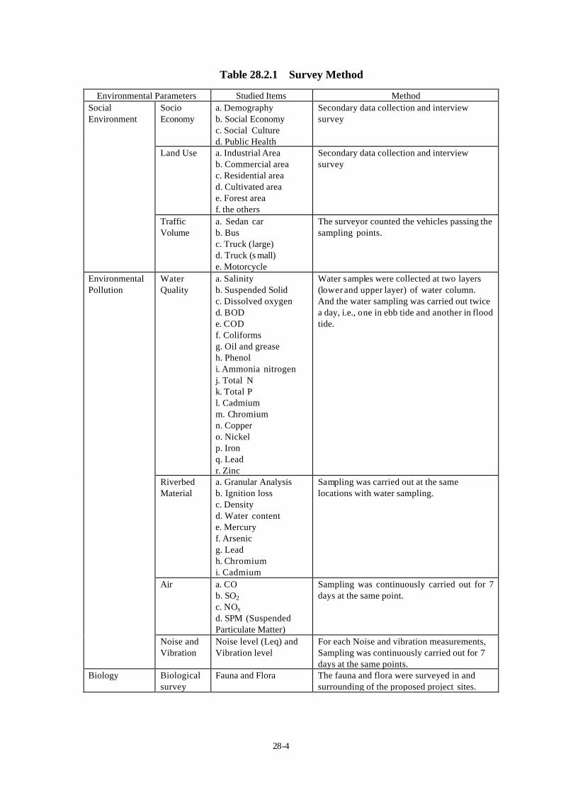
Survey items are summarized in Table 28.2.1
28-4
Table 28.2.1 Survey Method
Environmental Parameters Studied Items Method Socio Economy
a. Demography b. Social Economy c. Social Culture d. Public Health
Secondary data collection and interview survey
Land Use a. Industrial Area b. Commercial area c. Residential area d. Cultivated area e. Forest area f. the others
Secondary data collection and interview survey
Social Environment
Traffic Volume
a. Sedan car b. Bus c. Truck (large) d. Truck (s mall) e. Motorcycle
The surveyor counted the vehicles passing the sampling points.
Water Quality
a. Salinity b. Suspended Solid c. Dissolved oxygen d. BOD e. COD f. Coliforms g. Oil and grease h. Phenol i. Ammonia nitrogen j. Total N k. Total P l. Cadmium m. Chromium n. Copper o. Nickel p. Iron q. Lead r. Zinc
Water samples were collected at two layers (lower and upper layer) of water column. And the water sampling was carried out twice a day, i.e., one in ebb tide and another in flood tide.
Riverbed Material
a. Granular Analysis b. Ignition loss c. Density d. Water content e. Mercury f. Arsenic g. Lead h. Chromium i. Cadmium
Sampling was carried out at the same locations with water sampling.
Air a. CO b. SO2
c. NOx d. SPM (Suspended Particulate Matter)
Sampling was continuously carried out for 7 days at the same point.
Environmental Pollution
Noise and Vibration
Noise level (Leq) and Vibration level
For each Noise and vibration measurements, Sampling was continuously carried out for 7 days at the same points.
Biology Biological survey
Fauna and Flora The fauna and flora were surveyed in and surrounding of the proposed project sites.
28-5
The inventory of fauna and flora in the area was studied by field survey and interview survey, especially regarding Mangroves, Fish, and Animals.
28.2.2 Results of Environmental Condition Survey
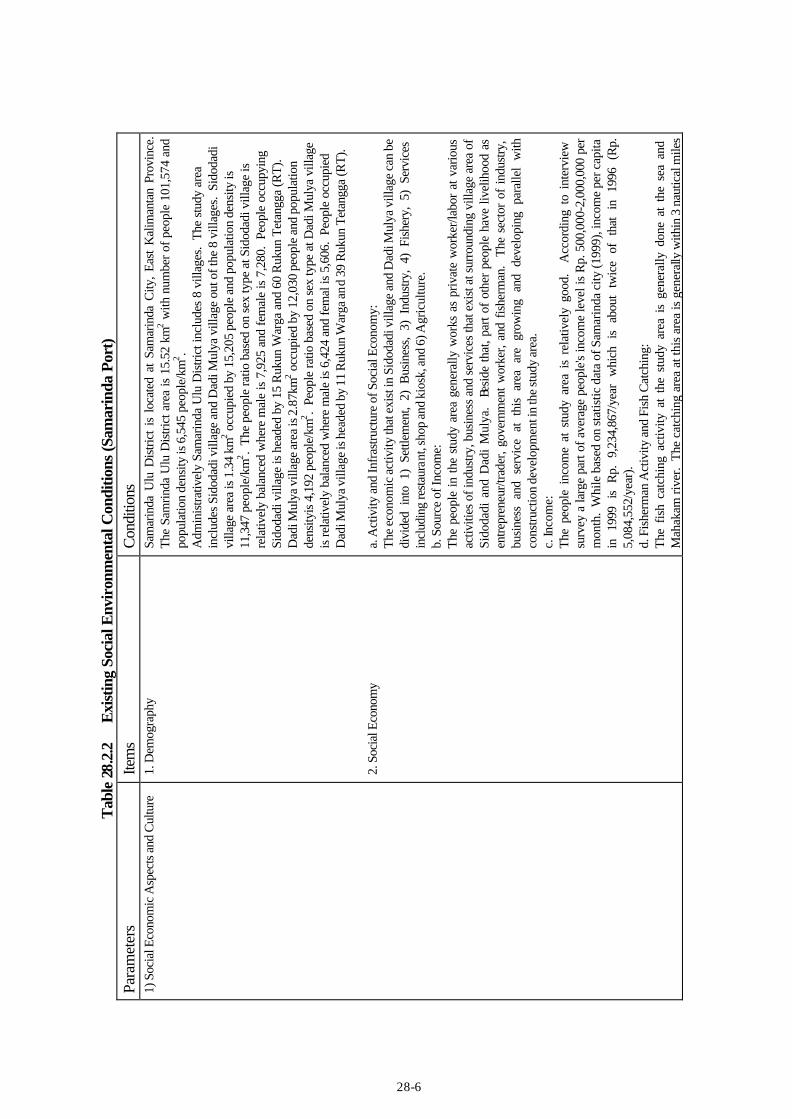
(1) Social Environment Present social environmental conditions are tabulated in Tables 28.2.2 and 28.2.3.
(2) Environmental Pollution Present environmental pollutions are tabulated in Tables 28.2.4 and 28.2.5.
(3) Biological Environment (Fauna and Flora)
1) Fauna Domestic animals are very common at the project site because the project site is man made ecosystem. Beside domestic animals, there are mammals, birds, reptiles, amphibia, and insects are existing around the project site.
2) Flora Vegetation that have been observed at Samarinda Port, East Kalimantan, and its surrounding area is cultivation plant. Those are horticulture, decorative plants, industrial plants, fruits, food crops, and vegetables.
3) Aquatic Biota a) Plankton
Based on investigation of the Laboratory Facultate Pertanian IPB Bogor (1993) the existing planktons in Mahakam River at Palaran site and Samarinda Port are 13 species.
b) Benthos Benthos is river bed organisms. As benthic organisms Mollusca, Crustacean and Worms are observed.
c) Nekton According to people information the observed fishes at Palaran site and Samarinda port are Baung (Macrones Microchantus), Puyau (Osteoochilus Hasselti), Jelawat (Leptobarbus Vaevenie), Repang (Osteo-chilus Repang), Biawan (Helostoma Temmiachki), Sepat Siam (Tricogasterpecto-Railis), Repuyu (Anabas Testudineus), Berukung (Barbictyyes Leavis), Salap (Putius Schwaneeldi), Lais (Belodon Tiechthyes-dinema), and Seluang (Chelaoxygastroides).
28-6
Tab
le 2
8.2.
2 E
xist
ing
Soci
al E
nvir
onm
enta
l Con
ditio
ns (S
amar
inda
Por
t) Pa
ram
eter
s Ite
ms
Con
ditio
ns
1) S
ocia
l Eco
nom
ic A
spec
ts a
nd C
ultu
re
1. D
emog
raph
y 2.
Soc
ial E
cono
my
Sam
arin
da U
lu D
istri
ct i
s lo
cate
d at
Sam
arin
da C
ity,
East
Kal
iman
tan
Prov
ince
.
The
Sam
rinda
Ulu
Dis
trict
are
a is
15.
52 k
m2 w
ith n
umbe
r of p
eopl
e 10
1,57
4 an
d po
pula
tion
dens
ity is
6,5
45 p
eopl
e/km
2 . A
dmin
istra
tivel
y Sa
mar
inda
Ulu
Dis
trict
incl
udes
8 v
illag
es.
The
stud
y ar
ea
incl
udes
Sid
odad
i vill
age
and
Dad
i Mul
ya v
illag
e ou
t of t
he 8
vill
ages
. Si
doda
di
villa
ge a
rea
is 1
.34
km2 o
ccup
ied
by 1
5,20
5 pe
ople
and
pop
ulat
ion
dens
ity is
11
,347
peo
ple/
km2 .
The
peop
le ra
tio b
ased
on
sex
type
at S
idod
adi v
illag
e is
re
lativ
ely
bala
nced
whe
re m
ale
is 7
,925
and
fem
ale
is 7
,280
. Pe
ople
occ
upyi
ng
Sido
dadi
vill
age
is h
eade
d by
15
Ruk
un W
arga
and
60
Ruk
un T
etan
gga
(RT)
. D
adi M
ulya
vill
age
area
is 2
.87k
m2 o
ccup
ied
by 1
2,03
0 pe
ople
and
pop
ulat
ion
dens
ityis
4,1
92 p
eopl
e/km
2 . Pe
ople
ratio
bas
ed o
n se
x ty
pe a
t Dad
i Mul
ya v
illag
e is
rela
tivel
y ba
lanc
ed w
here
mal
e is
6,4
24 a
nd fe
mal
is 5
,606
. Pe
ople
occ
upie
d D
adi M
ulya
vill
age
is h
eade
d by
11
Ruk
un W
arga
and
39
Ruk
un T
etan
gga
(RT)
. a.
Act
ivity
and
Infr
astru
ctur
e of
Soc
ial E
cono
my:
Th
e ec
onom
ic a
ctiv
ity th
at e
xist
in S
idod
adi v
illag
e an
d D
adi M
ulya
vill
age
can
be
divi
ded
into
1)
Settl
emen
t, 2)
Bus
ines
s, 3)
Ind
ustry
, 4)
Fis
hery
, 5)
Ser
vice
s in
clud
ing
rest
aura
nt, s
hop
and
kios
k, a
nd 6
) Agr
icul
ture
. b.
Sou
rce
of In
com
e: Th
e pe
ople
in th
e st
udy
area
gen
eral
ly w
orks
as
priv
ate
wor
ker/l
abor
at v
ario
us
activ
ities
of i
ndus
try, b
usin
ess
and
serv
ices
that
exi
st a
t sur
roun
ding
vill
age
area
of
Sido
dadi
and
Dad
i M
ulya
. B
esid
e th
at, p
art o
f ot
her
peop
le h
ave
livel
ihoo
d as
en
trepr
eneu
r/tra
der,
gove
rnm
ent
wor
ker,
and
fishe
rman
. Th
e se
ctor
of
indu
stry
, bu
sine
ss a
nd s
ervi
ce a
t th
is a
rea
are
grow
ing
and
deve
lopi
ng p
aral
lel
with
co
nstru
ctio
n de
velo
pmen
t in
the
stud
y ar
ea.
c.
Inco
me:
Th
e pe
ople
inc
ome
at s
tudy
are
a is
rel
ativ
ely
good
. A
ccor
ding
to
inte
rvie
w
surv
ey a
larg
e pa
rt of
ave
rage
peo
ple's
inco
me
leve
l is
Rp.
500
,000
-2,0
00,0
00 p
er
mon
th.
Whi
le b
ased
on
stat
istic
dat
a of
Sam
arin
da c
ity (1
999)
, inc
ome
per c
apita
in
19
99
is R
p. 9
,234
,867
/yea
r w
hich
is
abou
t tw
ice
of t
hat
in 1
996
(Rp.
5,
084,
552/
year
). d.
Fis
herm
an A
ctiv
ity a
nd F
ish
Cat
chin
g:
The
fish
catc
hing
act
ivity
at
the
stud
y ar
ea i
s ge
nera
lly d
one
at t
he s
ea a
nd
Mah
akam
rive
r. T
he c
atch
ing
area
at t
his
area
is g
ener
ally
with
in 3
nau
tical
mile
s

28-7
3. S
ocia
l Cul
ture
from
the
shor
e w
ith c
atch
ing
equi
pmen
t suc
h as
gill
net
and
usi
ng b
oat o
r mot
or
boat
. Fi
sher
man
act
ivity
is
gene
rally
in
high
tid
e.
The
fishe
rman
act
ivity
usu
ally
st
oppe
d du
ring
trans
fer
seas
on i
n W
est
win
d se
ason
to
Nor
th w
ind
seas
on.
D
urin
g th
is ti
me
man
y pe
ople
cha
nge
posi
tion
as w
orke
r and
farm
er fo
r foo
d cr
ops.
The
inte
rvie
w re
sults
with
fish
erm
en a
t the
stud
y ar
ea in
dica
te th
at a
par
t of i
ncom
e is
from
fish
cat
chin
g at
the
sea,
whi
le o
ther
par
t is f
rom
wor
k at
bus
ines
s sec
tor a
nd
serv
ice s
ecto
r as s
ide b
usin
ess.
Th
e fis
herie
s pot
entia
l at t
he st
udy
area
is o
ne o
f for
eign
exc
hang
e so
urce
for
Sam
arin
da c
ity.
Acc
ordi
ng to
Din
as P
erik
anan
of S
amar
inda
city
ann
ual r
epor
t 20
01, t
he v
olum
e of
sea
fish
catc
hing
is a
bout
2,9
05.7
ton
and
catc
hing
at f
resh
w
ater
is a
bout
2,7
77.3
ton.
The
ave
rage
resu
lts o
f fis
h ca
tchi
ng is
abo
ut 0
.2 k
g pe
r da
y. T
ype
of fi
sh a
re s
uch
as S
bela
h, M
anyu
n, B
elas
o, B
iji n
angk
a, B
awal
Hita
m,
Teri,
Ten
ggiri
Pap
an, T
una,
Kep
iting
, Cum
i-cu
mi K
akap
, Bel
anak
, Lay
ur, U
dang
pu
tih, e
tc.
a. G
over
nmen
t Adm
inis
tratio
n:
The
gove
rnm
ent
adm
inis
tratio
n at
Sid
odad
i vi
llage
and
Dad
i M
ulya
vill
age
is
serv
ed b
y a h
ead
villa
ge(L
urah
) and
assi
sted
by
a sec
reta
ry an
d af
fair
head
s, b
ut th
e ol
d cu
stom
s stil
l hav
e st
rong
influ
ence
to th
e pe
ople
. Th
is in
fluen
ce is
not
lim
ited
only
phy
sica
l m
atte
r bu
t al
so t
o th
e sp
iritu
al m
atte
r. T
hese
mat
ters
are
cle
arly
se
en d
urin
g co
nflic
t bet
wee
n pe
ople
whe
re th
e ol
der c
usto
ms a
re st
ill v
ery
requ
ired
and
easy
list
ened
by
the p
eopl
e.
b. S
truct
ure
of E
thni
c an
d R
elig
ion:
M
ajor
ity o
f eth
nic
grou
p ar
e as
follo
ws;
Lo
cal e
thni
c gr
oup:
Th
is e
thni
c gr
oup
is c
ompo
sed
of K
utai
eth
nic
as n
atur
e pe
ople
, and
Ban
jar e
thni
c as
inco
mer
from
the
near
est p
rovi
nce.
In
com
er e
thni
c gr
oup:
Th
ere
are
inco
mer
fro
m o
utsi
de o
f th
e Ea
st K
alim
anta
n pr
ovin
ce.
This
inco
mer
et
hnic
con
stitu
te B
ugis
gro
up a
nd J
ava
grou
p.
Bug
is c
onst
itute
fis
herm
an a
nd
busi
ness
man
, whe
reas
Java
gro
up is
bus
ines
s and
new
job
seek
er.
c. In
fras
truct
ure
of S
ocia
l-Cul
ture
: Th
ere
are
12 M
osqu
e, 2
0 M
usho
la (s
mal
l mos
que)
, and
1 C
hurc
h.
d. S
ocia
l val
ue a
nd A
spira
tion
of P
eopl
e:
Trad
ition
al p
roce
ss a
nd ro
le a
re s
till v
ery
clos
ely
done
at t
radi
tiona
l cer
emon
y in
th
e st
udy
area
.
28-8
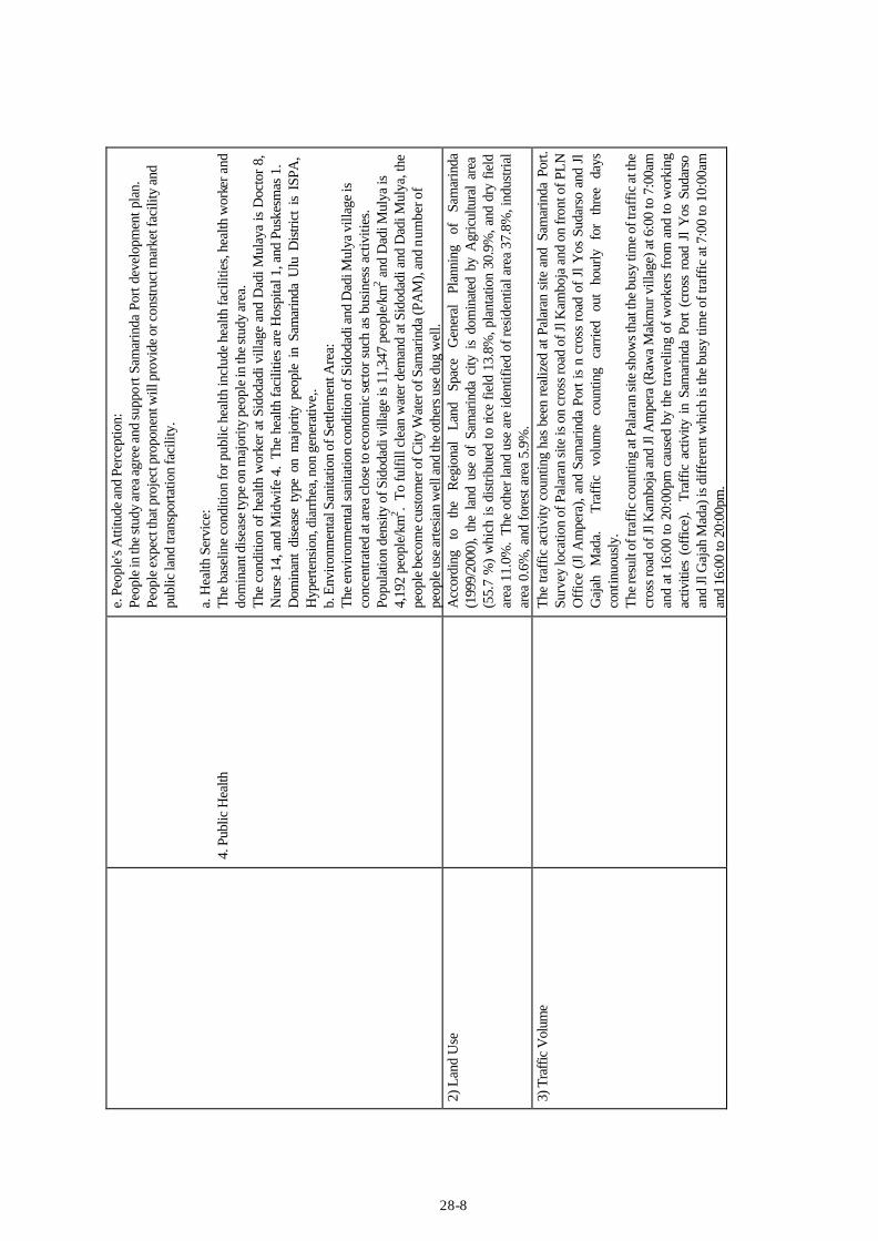
4. P
ublic
Hea
lth
e. P
eopl
e's A
ttitu
de a
nd P
erce
ptio
n:
Peop
le in
the
stud
y ar
ea a
gree
and
supp
ort S
amar
inda
Por
t dev
elop
men
t pla
n.
Peop
le e
xpec
t tha
t pro
ject
pro
pone
nt w
ill p
rovi
de o
r con
stru
ct m
arke
t fac
ility
and
pu
blic
land
tran
spor
tatio
n fa
cilit
y.
a. H
ealth
Ser
vice
: Th
e ba
selin
e co
nditi
on fo
r pub
lic h
ealth
incl
ude
heal
th fa
cilit
ies,
heal
th w
orke
r and
do
min
ant d
isea
se ty
pe o
n m
ajor
ity p
eopl
e in
the
stud
y ar
ea.
The
cond
ition
of h
ealth
wor
ker a
t Sid
odad
i vill
age
and
Dad
i Mul
aya
is D
octo
r 8,
Nur
se 1
4, a
nd M
idw
ife 4
. Th
e he
alth
faci
litie
s ar
e H
ospi
tal 1
, and
Pus
kesm
as 1
.
Dom
inan
t di
seas
e ty
pe o
n m
ajor
ity p
eopl
e in
Sam
arin
da U
lu D
istri
ct i
s IS
PA,
Hyp
erte
nsio
n, d
iarr
hea,
non
gen
erat
ive,
. b.
Env
ironm
enta
l San
itatio
n of
Set
tlem
ent A
rea:
Th
e en
viro
nmen
tal s
anita
tion
cond
ition
of S
idod
adi a
nd D
adi M
ulya
vill
age
is
conc
entra
ted
at a
rea
clos
e to
eco
nom
ic se
ctor
suc
h as
bus
ines
s ac
tiviti
es.
Popu
latio
n de
nsity
of S
idod
adi v
illag
e is
11,
347
peop
le/k
m2 a
nd D
adi M
ulya
is
4,19
2 pe
ople
/km
2 . To
fulfi
ll cl
ean
wat
er d
eman
d at
Sid
odad
i and
Dad
i Mul
ya, t
he
peop
le b
ecom
e cu
stom
er o
f City
Wat
er o
f Sam
arin
da (P
AM
), an
d nu
mbe
r of
peop
le u
se a
rtesi
an w
ell a
nd th
e ot
hers
use
dug
wel
l. 2)
Lan
d U
se
A
ccor
ding
to
th
e R
egio
nal
Land
Sp
ace
Gen
eral
Pl
anni
ng
of
Sam
arin
da
(199
9/20
00),
the
land
use
of
Sam
arin
da c
ity i
s do
min
ated
by
Agr
icul
tura
l ar
ea
(55.
7 %
) w
hich
is d
istri
bute
d to
rice
fiel
d 13
.8%
, pla
ntat
ion
30.9
%, a
nd d
ry fi
eld
area
11.
0%.
The
othe
r lan
d us
e ar
e id
entif
ied
of re
side
ntia
l are
a 37
.8%
, ind
ustri
al
area
0.6
%, a
nd fo
rest
are
a 5.
9%.
3)
Tra
ffic
Vol
ume
Th
e tra
ffic
act
ivity
cou
ntin
g ha
s be
en re
aliz
ed a
t Pal
aran
site
and
Sam
arin
da P
ort.
Su
rvey
loca
tion
of P
alar
an si
te is
on
cros
s roa
d of
Jl K
ambo
ja a
nd o
n fr
ont o
f PLN
O
ffic
e (J
l Am
pera
), an
d Sa
mar
inda
Por
t is
n cr
oss
road
of
Jl Y
os S
udar
so a
nd J
l G
ajah
M
ada.
Traf
fic
volu
me
coun
ting
carr
ied
out
hour
ly
for
thre
e da
ys
cont
inuo
usly
. Th
e re
sult
of tr
affic
cou
ntin
g at
Pal
aran
site
show
s tha
t the
bus
y tim
e of
traf
fic a
t the
cr
oss r
oad
of Jl
Kam
boja
and
Jl A
mpe
ra (R
awa
Mak
mur
vill
age)
at 6
:00
to 7
:00a
m
and
at 1
6:00
to 2
0:00
pm c
ause
d by
the
trave
ling
of w
orke
rs fr
om a
nd to
wor
king
ac
tiviti
es (
offic
e).
Traf
fic a
ctiv
ity i
n Sa
mar
inda
Por
t (c
ross
roa
d Jl
Yos
Sud
arso
an
d Jl
Gaj
ah M
ada)
is d
iffer
ent w
hich
is th
e bu
sy ti
me
of tr
affic
at 7
:00
to 1
0:00
am
and
16:0
0 to
20:
00pm
.

28-9
Tab
le 2
8.2.
3 E
xist
ing
Soci
al E
nvir
onm
enta
l Con
ditio
ns (P
alar
an S
ite)
Para
met
ers
Item
s C
ondi
tions
1)
Soc
ial E
cono
mic
Asp
ects
and
Cul
ture
1.
Dem
ogra
phy
2. S
ocia
l Eco
nom
y
3. S
ocia
l Cul
ture
Pala
ran
Dis
trict
is o
ne o
f the
Dis
trict
s lo
cate
d at
Sam
arin
da C
ity, E
ast K
alim
anta
n Pr
ovin
ce.
The
Pala
ran
Dis
trict
are
a is
241
.64
km2 w
ith n
umbe
r of p
eopl
e 35
,872
pe
ople
and
pop
ulat
ion
dens
ity in
this
dis
trict
is 1
48.4
5 pe
ople
/km
2 A
dmin
istra
tivel
y Pa
lara
n D
istri
ct h
as 6
vill
ages
incl
udin
g R
awa
Mak
mur
Vill
age
whi
ch is
the
stud
y ar
ea.
Raw
a M
akm
ur V
illag
e ar
ea is
11.
87 k
m2 (3
% o
f Pal
aran
D
istri
ct a
rea)
and
occ
upie
d by
11,
573
peop
le (3
2.36
% o
f Pal
aran
Dis
trict
peo
ple)
an
d po
pula
tion
dens
ity is
975
peo
ple/
km2 . T
he p
eopl
e ra
tio b
ased
on
sex
type
at
Raw
a M
akm
ur V
illag
e is
rela
tivel
y ba
lanc
ed, w
here
mal
e is
5,2
49 a
nd fe
mal
e is
6,
097.
Raw
a M
akm
ur V
illag
e ha
ving
11,
573
peop
le is
com
pose
d of
11
Ruk
un
War
ga (R
W) a
nd 4
3 R
ukun
Tet
angg
a (R
T).
Pala
ran
Dis
trict
are
a is
one
of t
he la
rge
area
in a
ll di
stric
ts in
clud
ed in
Sam
arin
da
City
, but
if c
ompa
red
with
num
ber o
f peo
ple
livin
g in
Pal
aran
Dis
trict
with
oth
er
Dis
trict
s, th
e nu
mbe
r of p
eopl
e is
the
smal
lest
(35,
872
peop
le).
The
larg
est
num
ber o
f peo
ple
is in
Sam
arin
da U
tara
Dis
trict
(130
,572
peo
ple)
. Th
e po
tent
ial e
cono
mic
act
ivity
that
exi
st in
Raw
a M
akm
ur V
illag
e up
to d
ate
can
be d
ivid
ed in
to s
ever
al p
arts
, tho
se a
re 1
) Agr
icul
ture
, 2) L
arge
Pot
entia
l Ind
ustry
, 3)
Mid
dle
Indu
stry
, 4)
Fish
ery,
and
5)
Serv
ices
incl
udin
g re
stau
rant
s, sh
ops,
and
kios
ks e
tc.
The
deve
lopm
ent o
f the
serv
ices
dur
ing
rece
nt th
ree-
year
s has
not
bee
n ve
ry fa
st
with
con
ditio
n of
exi
stin
g 58
unit
of k
iosk
s, 8
9 un
it of
shop
s, 4
uni
t of s
mal
l re
stau
rant
s and
1 v
illag
e un
it ba
nk (B
ank
Rak
yat I
ndon
esia
), al
so 1
uni
t of
tele
com
mun
icat
ion
shop
. M
arke
t for
oth
er e
cono
mic
act
iviti
es w
as n
ot fo
und
in
both
spec
ial b
uild
ing
and
sem
i per
man
ent b
uild
ing.
a.
Gov
ernm
ent A
dmin
istra
tion:
Th
e go
vern
men
t adm
inis
tratio
n at
Raw
a M
akm
ur is
ser
ved
by a
hea
d of
vill
age
(Lur
ah) a
nd a
ssis
ted
by a
sec
reta
ry a
nd a
ffai
r hea
ds, b
ut th
e ol
d cu
stom
s st
ill h
ave
stro
ng i
nflu
ence
to
the
peop
le.
Thi
s in
fluen
ce i
s no
t lim
ited
only
to
phys
ical
m
atte
r bu
t al
so t
o th
e sp
iritu
al m
atte
r. T
hese
mat
ters
are
cle
arly
sho
wn
durin
g co
nflic
t am
ong
peop
le w
here
the
old
er c
usto
ms
are s
till v
ery
requ
ired
and
easy
lis
tene
d by
the p
eopl
e.
At l
ower
leve
l of v
illag
e go
vern
men
t adm
inis
tratio
n is
ass
iste
d by
hea
d of
RW
and
R
T. R
awa
Mak
mur
Vill
age
cons
ists
of 1
1 R
W a
nd 4
3 R
T.
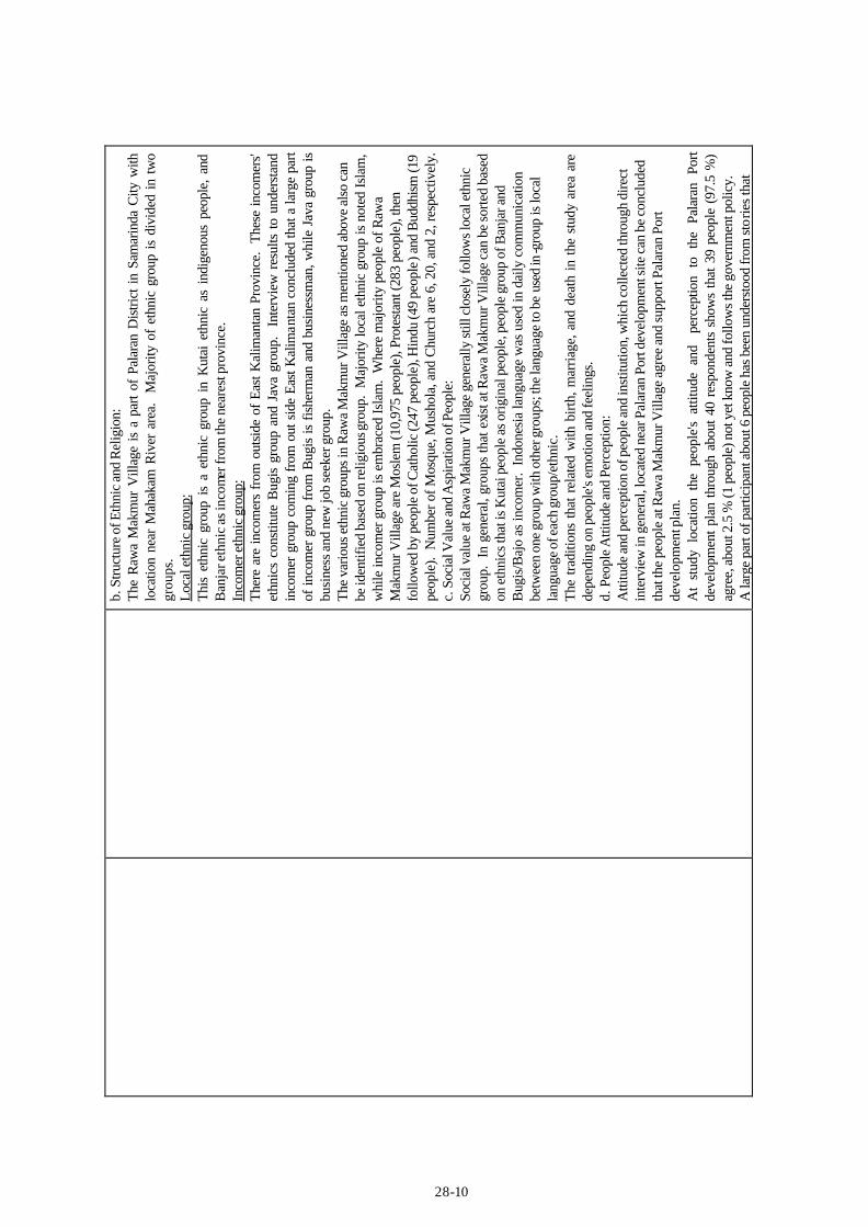
28-10
b. S
truct
ure
of E
thni
c an
d R
elig
ion:
Th
e R
awa
Mak
mur
Vill
age
is a
par
t of
Pala
ran
Dis
trict
in S
amar
inda
City
with
lo
catio
n ne
ar M
ahak
am R
iver
are
a.
Maj
ority
of
ethn
ic g
roup
is
divi
ded
in t
wo
grou
ps.
Loca
l eth
nic
grou
p:
This
eth
nic
grou
p is
a e
thni
c gr
oup
in K
utai
eth
nic
as i
ndig
enou
s pe
ople
, an
d B
anja
r eth
nic
as in
com
er fr
om th
e ne
ares
t pro
vinc
e.
Inco
mer
eth
nic
grou
p:
Ther
e ar
e in
com
ers
from
out
side
of
East
Kal
iman
tan
Prov
ince
. Th
ese
inco
mer
s' et
hnic
s co
nstit
ute
Bug
is g
roup
and
Jav
a gr
oup.
In
terv
iew
res
ults
to
unde
rsta
nd
inco
mer
gro
up c
omin
g fr
om o
ut s
ide
East
Kal
iman
tan
conc
lude
d th
at a
larg
e pa
rt of
inco
mer
gro
up f
rom
Bug
is is
fis
herm
an a
nd b
usin
essm
an, w
hile
Jav
a gr
oup
is
busi
ness
and
new
job
seek
er g
roup
. Th
e va
rious
eth
nic
grou
ps in
Raw
a M
akm
ur V
illag
e as
men
tione
d ab
ove
also
can
be
iden
tifie
d ba
sed
on re
ligio
us gr
oup.
Maj
ority
loca
l eth
nic
grou
p is
not
ed Is
lam
, w
hile
inco
mer
gro
up is
em
brac
ed Is
lam
. W
here
maj
ority
peo
ple
of R
awa
Mak
mur
Vill
age
are
Mos
lem
(10,
975
peop
le),
Prot
esta
nt (2
83 p
eopl
e), t
hen
follo
wed
by
peop
le o
f Cat
holic
(247
peo
ple)
, Hin
du (4
9 pe
ople
) and
Bud
dhism
(19
peop
le).
Num
ber o
f Mos
que,
Mus
hola
, and
Chu
rch
are
6, 2
0, a
nd 2
, res
pect
ivel
y.
c. S
ocia
l Val
ue an
d A
spira
tion
of P
eopl
e: So
cial
val
ue a
t Raw
a M
akm
ur V
illag
e ge
nera
lly st
ill c
lose
ly fo
llow
s loc
al e
thni
c gr
oup.
In
gene
ral,
grou
ps th
at e
xist a
t Raw
a M
akm
ur V
illag
e ca
n be
sorte
d ba
sed
on e
thni
cs th
at is
Kut
ai p
eopl
e as
orig
inal
peo
ple,
peo
ple
grou
p of
Ban
jar a
nd
Bug
is/B
ajo
as in
com
er.
Indo
nesi
a la
ngua
ge w
as u
sed
in d
aily
com
mun
icat
ion
betw
een
one
grou
p w
ith o
ther
gro
ups;
the
lang
uage
to b
e us
ed in
-gro
up is
loca
l la
ngua
ge o
f eac
h gr
oup/
ethn
ic.
The
tradi
tions
that
rel
ated
with
birt
h, m
arria
ge, a
nd d
eath
in th
e st
udy
area
are
de
pend
ing
on p
eopl
e's e
mot
ion
and
feel
ings
. d.
Peo
ple A
ttitu
de an
d Pe
rcep
tion:
A
ttitu
de a
nd p
erce
ptio
n of
peo
ple
and
inst
itutio
n, w
hich
col
lect
ed th
roug
h di
rect
in
terv
iew
in g
ener
al, l
ocat
ed n
ear P
alar
an P
ort d
evel
opm
ent s
ite c
an b
e co
nclu
ded
that
the
peop
le a
t Raw
a M
akm
ur V
illag
e ag
ree
and
supp
ort P
alar
an P
ort
deve
lopm
ent p
lan.
A
t st
udy
loca
tion
the
peop
le's
attit
ude
and
perc
eptio
n to
the
Pal
aran
Por
t de
velo
pmen
t pla
n th
roug
h ab
out 4
0 re
spon
dent
s sh
ows
that
39
peop
le (
97.5
%)
agre
e, a
bout
2.5
% (1
peo
ple)
not
yet
kno
w a
nd fo
llow
s the
gov
ernm
ent p
olic
y.
A la
rge
part
of p
artic
ipan
t abo
ut 6
peo
ple
has b
een
unde
rsto
od fr
om st
orie
s tha
t
28-11
4. P
ublic
Hea
lth
they
hea
r abo
ut P
alar
an P
ort d
evel
opm
ent p
lan.
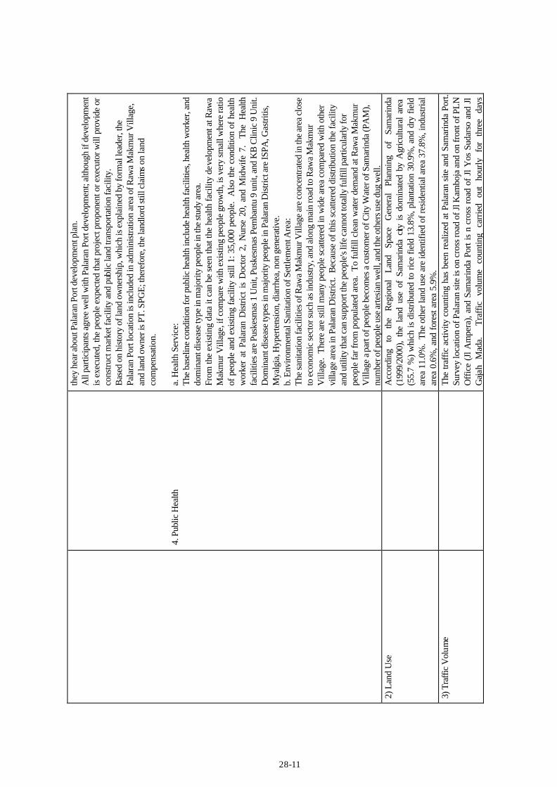
A
ll pa
rtici
pant
s agr
ee w
ell w
ith P
alar
an P
ort d
evel
opm
ent;
alth
ough
if d
evel
opm
ent
is e
xecu
ted,
the
peop
le e
xpec
ted
that
pro
ject
pro
pone
nt o
r exe
cuto
r will
pro
vide
or
cons
truct
mar
ket f
acili
ty a
nd p
ublic
land
tran
spor
tatio
n fa
cilit
y.
Bas
ed o
n hi
stor
y of
land
ow
ners
hip,
whi
ch is
exp
lain
ed b
y fo
rmal
lead
er, t
he
Pala
ran
Port
loca
tion
is in
clud
ed in
adm
inis
tratio
n ar
ea o
f Raw
a M
akm
ur V
illag
e,
and
land
ow
ner i
s PT.
SPG
E; th
eref
ore,
the
land
lord
still
cla
ims
on la
nd
com
pens
atio
n.
a. H
ealth
Ser
vice
: Th
e ba
selin
e co
nditi
on fo
r pub
lic h
ealth
incl
ude
heal
th fa
cilit
ies,
heal
th w
orke
r, an
d do
min
ant d
isea
se ty
pe in
maj
ority
peo
ple
in th
e st
udy
area
. Fr
om th
e ex
istin
g da
ta it
can
be
seen
that
the
heal
th fa
cilit
y de
velo
pmen
t at R
awa
Mak
mur
Vill
age,
if c
ompa
re w
ith e
xist
ing
peop
le g
row
th, i
s ver
y sm
all w
here
ratio
of
peo
ple
and
exis
ting
faci
lity
still
1: 3
5,00
0 pe
ople
. A
lso
the
cond
ition
of h
ealth
w
orke
r at
Pal
aran
Dis
trict
is
Doc
tor
2, N
urse
20,
and
Mid
wife
7.
The
Hea
lth
faci
litie
s are
Pus
kesm
as 1
Uni
t, Pu
skes
mas
Pem
bant
u 9
unit,
and
KB
Clin
ic 9
Uni
t. D
omin
ant d
isea
se ty
pes i
n m
ajor
ity p
eopl
e in
Pal
aran
Dis
trict
are
ISPA
, Gas
tritis
, M
yalg
ia, H
yper
tens
ion,
dia
rrhe
a, n
on g
ener
ativ
e.
b. E
nviro
nmen
tal S
anita
tion
of S
ettle
men
t Are
a:
The
sani
tatio
n fa
cilit
ies o
f Raw
a M
akm
ur V
illag
e ar
e co
ncen
trate
d in
the
area
clo
se
to e
cono
mic
sect
or su
ch a
s ind
ustry
, and
alo
ng m
ain
road
to R
awa
Mak
mur
V
illag
e. T
here
are
stil
l man
y pe
ople
sca
ttere
d in
wid
e ar
ea c
ompa
red
with
oth
er
villa
ge a
rea
in P
alar
an D
istri
ct.
Bec
ause
of t
his
scat
tere
d di
strib
utio
n th
e fa
cilit
y an
d ut
ility
that
can
supp
ort t
he p
eopl
e's li
fe c
anno
t tot
ally
fulfi
ll pa
rticu
larly
for
peop
le fa
r fro
m p
opul
ated
are
a. T
o fu
lfill
clea
n w
ater
dem
and
at R
awa
Mak
mur
V
illag
e a p
art o
f peo
ple
beco
mes
a c
usto
mer
of C
ity W
ater
of S
amar
inda
(PA
M),
num
ber o
f peo
ple
use
arte
sian
wel
l, an
d th
e ot
hers
use
dug
wel
l. 2)
Lan
d U
se
A
ccor
ding
to
th
e R
egio
nal
Land
Sp
ace
Gen
eral
Pl
anni
ng
of
Sam
arin
da
(199
9/20
00),
the
land
use
of
Sam
arin
da c
ity i
s do
min
ated
by
Agr
icul
tura
l ar
ea
(55.
7 %
) w
hich
is d
istri
bute
d to
ric
e fie
ld 1
3.8%
, pla
ntat
ion
30.9
%, a
nd d
ry f
ield
ar
ea 1
1.0%
. Th
e ot
her l
and
use
are
iden
tifie
d of
resi
dent
ial a
rea
37.8
%, i
ndus
trial
ar
ea 0
.6%
, and
fore
st a
rea
5.9%
.
3) T
raffi
c V
olum
e
The
traff
ic a
ctiv
ity c
ount
ing
has
been
rea
lized
at P
alar
an s
ite a
nd S
amar
inda
Por
t.
Surv
ey lo
catio
n of
Pal
aran
site
is o
n cr
oss r
oad
of Jl
Kam
boja
and
on
fron
t of P
LN
Off
ice
(Jl A
mpe
ra),
and
Sam
arin
da P
ort i
s n
cros
s ro
ad o
f Jl
Yos
Sud
arso
and
Jl
Gaj
ah
Mad
a.
Tr
affic
vo
lum
e co
untin
g ca
rrie
d ou
t ho
urly
fo
r th
ree
days
28-12
cont
inuo
usly
. Th
e re
sult
of tr
affic
cou
ntin
g at
Pal
aran
site
show
s tha
t the
bus
y tim
e of
traf
fic a
t the
cr
oss r
oad
of Jl
Kam
boja
and
Jl A
mpe
ra (R
awa
Mak
mur
vill
age)
at 6
:00
to 7
:00a
m
and
at 1
6:00
to 2
0:00
pm c
ause
d by
the
trave
ling
of w
orke
rs fr
om a
nd to
wor
king
ac
tiviti
es (
offic
e).
Traf
fic a
ctiv
ity i
n Sa
mar
inda
Por
t (c
ross
roa
d Jl
Yos
Sud
arso
an
d Jl
Gaj
ah M
ada)
is d
iffer
ent w
hich
is th
e bu
sy ti
me
of tr
affic
at 7
:00
to 1
0:00
am
and
16:0
0 to
20:
00pm
.

28-13
Tab
le 2
8.2.
4 E
nvir
onm
enta
l Pol
lutio
n (S
amar
inda
Por
t and
Est
urar
y A
rea)
Para
met
ers
Item
s C
ondi
tions
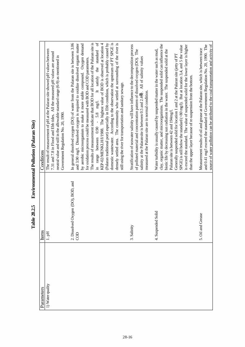
1)
Wat
er q
ualit
y
1.
pH
2.
Dis
solv
ed O
xyge
n (D
O),
BO
D, a
nd
CO
D
3. S
alin
ity
4. S
uspe
nded
Sol
id
The
resu
lt of
wat
er q
ualit
y m
easu
rem
ent i
n th
e Sa
mar
inda
Por
t ind
icat
es th
at p
H is
be
twee
n 7.
24 a
nd 7
.77
in fl
ood
tide
and
ebb t
ide
cond
ition
. B
ut p
H in
the
estu
ary
area
of M
ahak
am R
iver
is h
ighe
r tha
n th
at o
f the
Sam
arin
da P
ort.
Esp
ecia
lly in
Eb
b co
nditi
on p
H is
hig
h be
ing
betw
een
7.21
and
8.0
8. A
ll th
e m
easu
red
pH
valu
es a
re a
roun
d ne
utra
l val
ue a
nd st
ill in
the
allo
wab
le st
anda
rd ra
nge
(6-9
) as
men
tione
d in
Gov
ernm
ent R
egul
atio
n N
o. 2
0, 1
990.
In
gen
eral
Dis
solv
ed o
xyge
n (D
O) o
f wat
er q
ualit
y at
Sam
arin
da P
ort a
nd e
stua
ry
area
of M
ahak
am R
iver
is st
ill sa
tisfy
the
stan
dard
(> 4
mg/
l).
The
mea
sure
men
t re
sults
ind
icat
e th
at B
OD
for
all
loca
tions
of
Sam
arin
da P
ort
wat
er is
rang
e be
twee
n 0.
85 –
1.9
0 m
g/l a
nd in
the
estu
ary
area
is b
etw
een
0.8
– 1.
45 m
g/l,
but
is s
till
satis
fy t
he s
tand
ard.
Th
e hi
ghes
t B
iolo
gica
l O
xyge
n D
eman
d (B
OD
) is
obse
rved
on
loca
tion
5 be
caus
e of
dom
estic
was
tew
ater
inflo
w
espe
cial
ly d
urin
g th
e Fl
ood
cond
ition
. Th
e up
stre
am o
f K
aran
g M
umus
Riv
er is
th
e de
nsel
y po
pula
ted
area
. Th
e co
mm
uniti
es s
ettle
d al
ong
the
river
are
a is
still
us
ing
the
river
wat
er fo
r tra
nspo
rtatio
n an
d al
so fo
r sew
age.
C
hem
ical
Oxy
gen
Dem
and
(CO
D) i
n th
e es
tuar
y ar
ea o
f Mah
akam
Riv
er a
t the
lo
catio
n 1
(21.
61 –
255
.4 m
g/l)
exce
eds
the
stan
dard
, but
at th
e lo
catio
n 2
and
the
loca
tion
at S
amar
inda
Por
t is
belo
w th
e al
low
able
lim
it of
the
stan
dard
. Th
e hi
gh
CO
D v
alue
s in
the
estu
ary
may
be
attri
bute
d to
Sal
ty w
ater
and
und
egra
dabl
e or
gani
c m
atte
r in
the
estu
ary.
La
bora
tory
ana
lysi
s ind
icat
es th
at th
e va
lue
of sa
linity
is d
iffer
ent a
mon
g th
e lo
catio
ns 1
, 2, a
nd o
ther
s. T
he s
alin
ity a
t loc
atio
ns 3
, 4, a
nd 5
is b
etw
een
0.24
and
0.
95‰
. G
ener
ally
the
salin
ity o
f wat
er in
ebb
con
ditio
n is
hig
her t
han
in fl
ood
cond
ition
. Th
e sa
linity
at t
he e
stua
ry a
rea
is fr
om 9
.6 to
33.
4‰.
Susp
ende
d m
atte
r in
th
e w
ater
su
ch
as
mud
, cl
ay,
orga
nic
mat
ter,
and
mic
roor
gani
sm u
sual
ly c
ause
s w
ater
turb
idity
. Th
e su
spen
ded
solid
can
influ
ence
aq
uatic
life
by
decr
easin
g th
e su
n ra
diat
ion
into
the
wat
er.
The
tota
l sus
pend
ed
solid
val
ue a
t the
Sam
arin
da P
ort (
loca
tion
3,4
and
5) is
bet
wee
n 26
and
76
mg/
l an
d th
at in
est
uary
are
a of
Mah
akam
Riv
er is
bet
wee
n 18
and
90
mg/
l. G
ener
ally
, sus
pend
ed so
lid fo
r all
of sa
mpl
ing
loca
tions
in e
stua
ry a
rea
of
Mah
akam
Riv
er is
still
bel
ow th
e st
anda
rd (<
80
mg/
l) ex
cept
dur
ing
ebb
tide
28-14
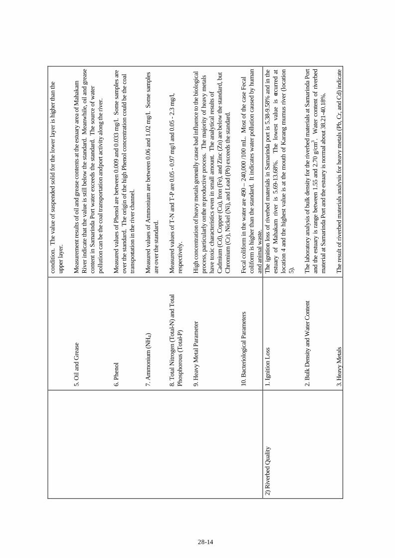
5. O
il an
d G
reas
e 6.
Phe
nol
7. A
mm
oniu
m (N
H4)
8.
Tot
al N
itrog
en (T
otal
-N) a
nd T
otal
Ph
osph
orou
s (To
tal-P
) 9.
Hea
vy M
etal
Par
amet
er
10. B
acte
riolo
gica
l Par
amet
ers
cond
ition
. Th
e va
lue
of su
spen
ded
solid
for t
he lo
wer
laye
r is h
ighe
r tha
n th
e up
per l
ayer
. M
easu
rem
ent r
esul
ts o
f oil
and
grea
se c
onte
nts a
t the
est
uary
are
a of
Mah
akam
R
iver
indi
cate
that
the
valu
e is
still
bel
ow th
e st
anda
rd.
Mea
nwhi
le, o
il an
d gr
ease
co
nten
t in
Sam
arin
da P
ort w
ater
exc
eeds
the
stan
dard
. Th
e so
urce
of w
ater
po
llutio
n ca
n be
the
coal
tran
spor
tatio
n an
d por
t act
ivity
alon
g th
e riv
er.
Mea
sure
d va
lues
of P
heno
l are
bet
wee
n 0.
009
and
0.03
3 m
g/l.
Som
e sa
mpl
es a
re
over
the
stan
dard
. Th
e or
igin
of t
he h
igh
Phen
ol c
once
ntra
tion
coul
d be
the
coal
tra
nspo
rtatio
n in
the
river
cha
nnel
. M
easu
red
valu
es o
f Am
mon
ium
are
bet
wee
n 0.
06 a
nd 1
.02
mg/
l. S
ome
sam
ples
ar
e ove
r the
stan
dard
. M
easu
red
valu
es o
f T-N
and
T-P
are
0.0
5 - 0
.97
mg/
l and
0.0
5 - 2
.3 m
g/l,
resp
ectiv
ely.
H
igh
conc
entra
tion
of h
eavy
met
als g
enera
lly c
ause
bad
influ
ence
to th
e bi
olog
ical
pr
oces
s, p
artic
ular
ly o
n the
repr
oduc
tive
proc
ess.
The
maj
ority
of h
eavy
met
als
have
toxi
c ch
arac
teris
tics
even
in s
mal
l am
ount
. Th
e an
alyt
ical
resu
lts o
f C
adm
ium
(Cd)
, Cop
per (
Cu)
, Iro
n (F
e), a
nd Z
inc
(Zn)
are
bel
ow th
e st
anda
rd, b
ut
Chr
omiu
m (C
r), N
icke
l (N
i), a
nd L
ead
(Pb)
exc
eeds
the
stan
dard
. Fe
cal c
olifo
rm in
the
wat
er a
re 4
90 –
240
,000
/100
mL.
Mos
t of t
he c
ase
Feca
l co
lifor
m is
hig
her t
han
the
stan
dard
. It
indi
cate
s w
ater
pol
lutio
n ca
used
by
hum
an
and
anim
al w
aste
. 2)
Riv
erbe
d Q
ualit
y 1.
Igni
tion
Loss
2.
Bul
k D
ensi
ty a
nd W
ater
Con
tent
3.
Hea
vy M
etal
s
The
igni
tion
loss
of
river
bed
mat
eria
ls in
Sam
arin
da p
ort i
s 5.
38-9
.58%
and
in th
e es
tuar
y of
Mah
akam
riv
er i
s 5.
69-1
3.68
%.
The
low
est
valu
e is
occ
urre
d at
lo
catio
n 4
and
the
high
est v
alue
is a
t the
mou
th o
f Kar
ang
mum
us ri
ver (
loca
tion
5).
The
labo
rato
ry a
naly
sis o
f bul
k de
nsity
for t
he ri
verb
ed m
ater
ials
at S
amar
inda
Por
t an
d th
e es
tuar
y is
rang
e be
twee
n 1.
55 a
nd 2
.70
g/cm
3 . W
ater
con
tent
of
river
bed
mat
eria
l at S
amar
inda
Por
t and
the
estu
ary
is n
orm
al a
bout
38.
21-4
0.18
%.
The
resu
lt of
rive
rbed
mat
eria
ls a
naly
sis f
or h
eavy
met
als (
Pb, C
r, an
d C
d) in
dica
te
28-15
th
at it
is n
orm
al a
nd so
me
of p
aram
eter
s are
und
etec
ted
(Hg
and
As)
. 3)
Air
Qua
lity
and
Noi
se
To
und
erst
and
air q
ualit
y in
and
aro
und
Sam
arin
da a
rea
air q
ualit
y pa
ram
eter
s suc
h as
SO
2, N
Ox,
CO
, SPM
and
Noi
se a
re m
easu
re.
The
air
qual
ity m
easu
rem
ent o
f th
e Pa
lara
n si
te a
nd S
amar
inda
Por
t sho
wed
that
SO
2 va
lue
of 0
.023
-0.0
53 m
g/m
3 , N
O2
valu
e of
0.0
6-0.
089
mg/
m3 , C
O2
valu
e of
0.4
3 m
g/m3 , a
nd S
PM v
alue
of
0.04
2-0.
31 m
g/m
3 . G
ener
ally
air
qual
ity a
t Sam
arin
da a
rea
is in
goo
d co
nditi
on
whe
re a
ll pa
ram
eter
s ar
e st
ill b
elow
the
env
ironm
enta
l st
anda
rd,
exce
pt d
ust
cont
ent
for
poin
t 1
and
2 an
d 4.
Th
e no
ise
leve
l is
min
imum
55
dB (
A)
and
max
imum
90
dB (
A).
Noi
se l
evel
in
the
stud
y ar
ea i
s ov
er t
he e
nviro
nmen
tal
stan
dard
.
28-16
Tab
le 2
8.2.
5 E
nvir
onm
enta
l Pol
lutio
n (P
alar
an S
ite)
Para
met
ers
Item
s C
ondi
tions
1)
Wat
er q
ualit
y
1. p
H
2. D
isso
lved
Oxy
gen
(DO
), B
OD
, and
C
OD
3.
Sal
inity
4.
Sus
pend
ed S
olid
5.
Oil
and
Gre
ase
The
resu
lt of
mea
sure
men
t of p
H a
t the
Pal
aran
site
show
ed p
H v
alue
s bet
wee
n 7.
31 a
nd 7
.8 in
Flo
od a
nd E
bb ti
des.
All
the
mea
sure
d pH
val
ues
are
arou
nd
neut
ral v
alue
and
still
in th
e al
low
able
stan
dard
rang
e (6
-9) a
s m
entio
ned
in
Gov
ernm
ent R
egul
atio
n N
o. 2
0, 1
990.
In
gen
eral
dis
solv
ed o
xyge
n (D
O) o
f wat
er fr
om th
e Pa
lara
n si
te is
bet
wee
n 3.
06
and
3.90
mg/
l. D
isso
lved
oxy
gen
is r
equi
red
to o
xidi
ze d
isso
lved
org
anic
mat
ter
by a
erob
ic m
icro
orga
nism
to
mak
e it
mor
e st
able
com
poun
d.
Oxy
gen
dem
and
for o
xida
tion
proc
ess c
ould
be
mea
sure
d w
ith B
OD
and
CO
D p
aram
eter
s. Th
e re
sults
of m
easu
rem
ent i
ndic
ate
that
BO
D fo
r all
loca
tion
of th
e Pa
lara
n si
te is
in
ra
nge
betw
een
0.90
-
5.8
mg/
l.
It sa
tisfy
th
e st
anda
rd
of
KEP
-02/
MEN
KLH
/I/19
88.
The
high
est v
alue
of
BO
D is
obs
erve
d at
loca
tion
4 (P
alar
an tr
aditi
onal
por
t) es
peci
ally
in E
bb c
ondi
tion,
whi
ch is
pro
babl
y ca
used
by
dom
estic
was
tew
ater
. A
ccor
ding
to th
e ob
serv
atio
n th
e up
stre
am o
f PT
SPG
E is
de
nsel
y se
ttled
are
a.
The
com
mun
ity w
ho s
ettle
d at
sur
roun
ding
of
the
river
is
still
usi
ng th
e riv
er fo
r tra
nspo
rtatio
n an
d sa
nita
ry se
wag
e.
Stra
tific
atio
n of
seaw
ater
salin
ity w
ill h
ave
influ
ence
to th
e de
com
posi
tion
proc
ess
of p
ollu
ted
mat
eria
l and
con
cent
ratio
n pa
ttern
of d
isso
lved
oxy
gen
(DO
). T
he
salin
ity a
t the
Pal
aran
site
is b
etw
een
0.5
and
2.4‰
. A
ll of
sal
inity
val
ues
mea
sure
d at
the
Pala
ran
site
are
in n
orm
al c
ondi
tion.
W
ater
turb
idity
is u
sual
ly c
ause
d by
susp
ende
d m
atte
r in
the
wat
er su
ch a
s mud
, cl
ay, o
rgan
ic m
atte
r, an
d m
icro
orga
nism
s. T
he s
uspe
nded
sol
id c
an in
fluen
ce th
e bi
otic
life
by
decr
easi
ng su
n ra
diat
ion
in th
e w
ater
. Th
e su
spen
ded
solid
at t
he
Pala
ran
site
is b
etw
een
42 a
nd 1
94m
g/l.
Gen
eral
ly su
spen
ded
solid
for l
ocat
ion
1 an
d 2
at th
e Pa
lara
n si
te (j
etty
of P
T SP
GE)
is st
ill b
elow
the
stan
dard
(<80
mg/
l). B
ut a
t loc
atio
n 3,
4, a
nd 5
the
valu
e is
exc
eed
the
stan
dard
. Th
e va
lue
of su
spen
ded
solid
for t
he lo
wer
laye
r is h
ighe
r th
an th
e up
per l
ayer
bec
ause
of r
e-su
spen
sion
from
the
botto
m.
Mea
sure
men
t res
ults
of o
il an
d gr
ease
at t
he P
alar
an si
te, w
hich
is b
etw
een
trace
an
d 0.
41 m
g/l e
xcee
d th
e st
anda
rd o
f Gov
ernm
ent R
egul
atio
n N
o. 2
0, 1
990.
The
so
urce
of w
ater
pol
lutio
n ca
n be
attr
ibut
ed to
the
coal
tran
spor
tatio
n an
d ac
tivity
of
28-17
6. P
heno
l 7.
Am
mon
ium
(NH
4)
8. T
otal
Nitr
ogen
(Tot
al-N
) and
Tot
al
Phos
phor
ous (
Tota
l-P)
9. H
eavy
Met
al P
aram
eter
10
. Bac
terio
logi
cal P
aram
eter
s
ship
load
ing/
unlo
adin
g in
Mah
akam
rive
r. M
easu
red
valu
es o
f Phe
nol a
re b
etw
een
0.00
9 an
d 0.
013
mg/
l, w
hich
are
ove
r the
st
anda
rd.
The
orig
in o
f the
hig
h Ph
enol
con
cent
ratio
n co
uld
be th
e co
al
trans
porta
tion
in th
e riv
er c
hann
el.
Mea
sure
d va
lues
of A
mm
oniu
m a
re b
etw
een
0.43
and
0.7
5 m
g/l,
whi
ch a
re b
elow
th
e sta
ndar
d.
Mea
sure
d va
lues
of T
-N a
nd T
-P a
re 0
.34
- 0.5
8 m
g/l a
nd 0
.22
- 2.6
4 m
g/l,
resp
ectiv
ely.
M
etal
in w
ater
is u
sual
ly c
omin
g fr
om n
atur
al s
ourc
es a
nd h
uman
act
iviti
es.
Hig
h co
ncen
tratio
n of
met
als i
n w
ater
gen
eral
ly c
ause
s bad
influ
ence
to th
e bi
olog
ical
pr
oces
s, p
artic
ular
ly o
n re
prod
uctiv
e pr
oces
s. M
ajor
ity o
f hea
vy m
etal
hav
e to
xic
char
acte
ristic
s ev
en in
low
con
cent
ratio
n. A
naly
tical
resu
lts o
f Cad
miu
m (C
d),
Cup
per (
Cu)
, Iro
n (F
e), a
nd Z
inc
(Zn)
are
bel
ow th
e st
anda
rd.
But
Chr
omiu
m
(Cr)
and
Lea
d (P
b) a
re o
ver t
he st
anda
rd.
Orig
in o
f the
se h
igh
conc
entra
tion
of
met
al is
from
the
coal
tran
spor
tatio
n in
the
river
cha
nnel
. Fe
cal c
olifo
rm in
the
wat
er a
re 3
,500
– 1
60,0
00/1
00 m
L. M
ost o
f the
cas
e Fe
cal
colif
orm
is h
ighe
r tha
n th
e st
anda
rd.
It in
dica
tes
wat
er p
ollu
tion
caus
ed b
y hu
man
an
d an
imal
was
te.
2) R
iver
bed
Qua
lity
1. Ig
nitio
n Lo
ss
2. B
ulk
Den
sity
and
Wat
er C
onte
nt
3. H
eavy
Met
als
The
aver
age
igni
tion
loss
of
river
bed
mat
eria
ls i
s be
twee
n 5.
17-1
3.25
%.
The
low
est v
alue
is o
ccur
red
at lo
catio
n 3
and
the
high
est v
alue
is a
t loc
atio
n 5
(eas
t of
PT S
PGE)
. B
ulk
dens
ity o
f riv
erbe
d m
ater
ials
at P
alar
an s
ite is
bet
wee
n 1.
01 a
nd 2
.75
g/cm
3 .
Wat
er c
onte
nt o
f riv
erbe
d m
ater
ial a
t Pal
aran
site
is n
orm
al a
bout
38.
22-4
3.10
%.
The
resu
lt of
rive
rbed
mat
eria
l ana
lysi
s fo
r hea
vy m
etal
s (H
g, A
s, Pb
, Cr,
and
Cd)
in
dica
ted
that
they
are
in n
orm
al v
alue
s. 3)
Air
Qua
lity
and
Noi
se
To
und
erst
and
air q
ualit
y in
and
aro
und
Sam
arin
da a
rea
air q
ualit
y pa
ram
eter
s suc
h as
SO
2, N
Ox,
CO
, SPM
and
Noi
se a
re m
easu
re.
The
air
qual
ity m
easu
rem
ent o
f th
e Pa
lara
n si
te a
nd S
amar
inda
Por
t sho
wed
that
SO
2 va
lue
of 0
.023
-0.0
53 m
g/m
3 , N
O2
valu
e of
0.0
6-0.
089
mg/
m3 , C
O2
valu
e of
0.4
3 m
g/m3 , a
nd S
PM v
alue
of
0.04
2-0.
31 m
g/m
3 . G
ener
ally
air
qual
ity a
t Sam
arin
da a
rea
is in
goo
d co
nditi
on
28-18
whe
re a
ll pa
ram
eter
s ar
e st
ill b
elow
the
env
ironm
enta
l st
anda
rd,
exce
pt d
ust
cont
ent
for
poin
t 1
and
2 an
d 4.
Th
e no
ise
leve
l is
min
imum
55
dB (
A)
and
max
imum
90
dB (
A).
Noi
se l
evel
in
the
stud
y ar
ea i
s ov
er t
he e
nviro
nmen
tal
stan
dard
.
28-19
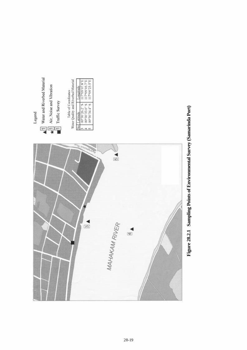
Figu
re 2
8.2.
1 Sa
mpl
ing
Poin
ts o
f Env
iron
men
tal S
urve
y (S
amar
inda
Por
t)
28-20
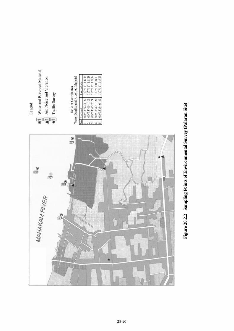
Figu
re 2
8.2.
2 Sa
mpl
ing
Poin
ts o
f Env
iron
men
tal S
urve
y (P
alar
an S
ite)

28-21
Figure 28.2.3 Sampling Points of Environmental Survey (Estuary Area)
29-1
29. SITE SELECTION 29.1 Planning Aspects 29.1.1 Container Terminal (1) Candidate Port Development Sites The existing Samarinda Port is extremely congested with increasing port cargo and passengers. Containerization has been also accelerated year by year. The port needs to cope with containerization very urgently. Needless to say, container cargo handling requires a large amount of space behind a wharf. The necessary depth of a container terminal should be at least 200 m. However, the breadth of wharves at the existing port is only 40 m to 75 m. In addition, there is no more extension area on both sides of the port, because the port has been completely surrounded by the central business district of the Samarinda City. Therefore, the existing port is not suitable for container cargo handling, which will be dominant cargo at Samarinda in the near future. In spite of this, the port has to accept a rapidly growing container cargo at the existing port until a new container terminal is developed and operational. On the other hand, the existing port is still useful for general cargo handling, because it is provided with 827 m long wharves with 40 m to 75 m wide yard behind them. If the existing port is specialized in a general cargo port, the port function is fully strengthened and efficiently utilized. From this point of view, the Study Team recommends a new container terminal development in other place, which is able to secure the sufficient container cargo handling space within a terminal. At the same time, the existing port should be used as a general cargo terminal in the long run, and the existing passenger terminal should be relocated when the existing port is filled with gradually increasing general cargo in future. There are three candidate places for a new container terminal within the port hinterland of Samarinda. The first is Marang Kayu, facing the open sea and 50 km away from the City of Samarinda (Figure 29.1.1). The second is Mangku Palas, owned by IPC 4, and on the opposite site of the Mahakam River to the existing port (Figure 29.1.2). And the third is Palaran, the former timber factory, now under mortgage to the Indonesian Bank Restructuring Agency (IBRA), 14 km downstream on the opposite site of the Mahakam River to the existing port (Figure 29.1.3). (2) Preliminary Master Plan Study at Marang Kayu 1) 6 Meter-draft Container Port Plan a. Project Profile The layout Plan for 2025 is shown in Figure 29.1.4. Main components of the plan are shown in Figure 29.1.5. The Study Team plans to create a new modern container terminal at Marang Kayu on condition that the port basin will not be buried under coastal drift sand when a breakwater is extended up to –3m depth water area. This plan also requires land acquisition, a large amount of capital dredging, long breakwater construction, river estuary works and long port access road. b. Container Terminal
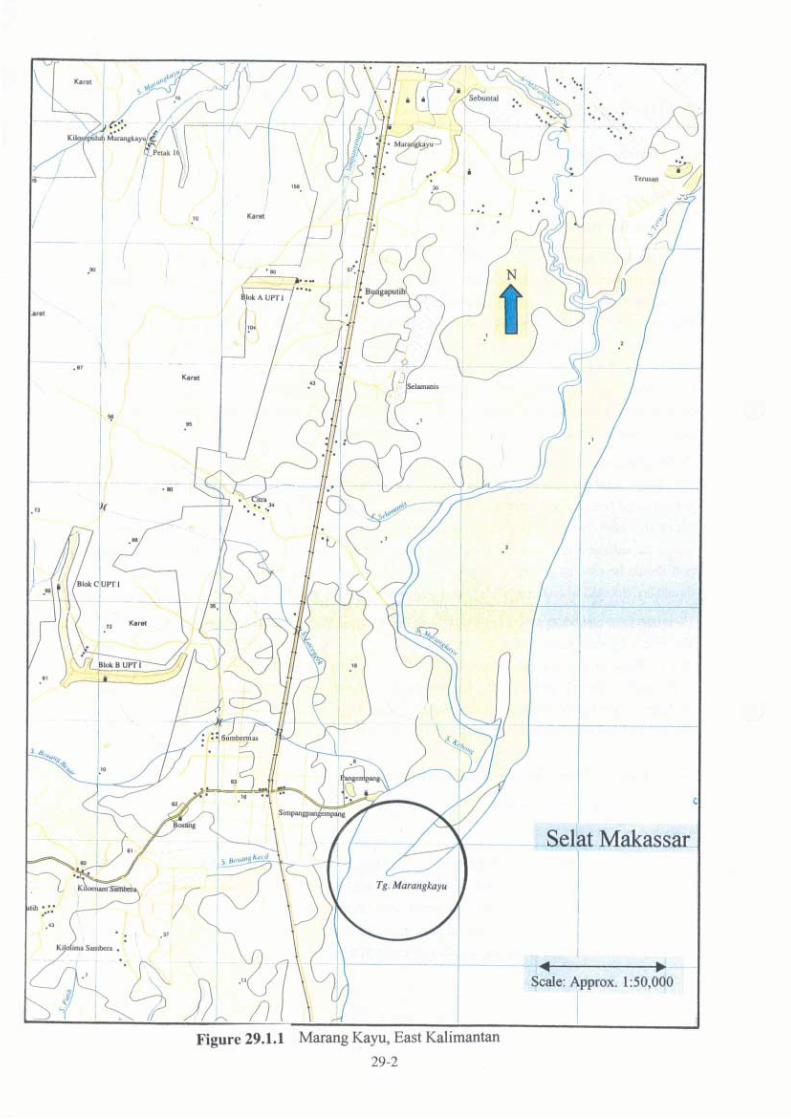
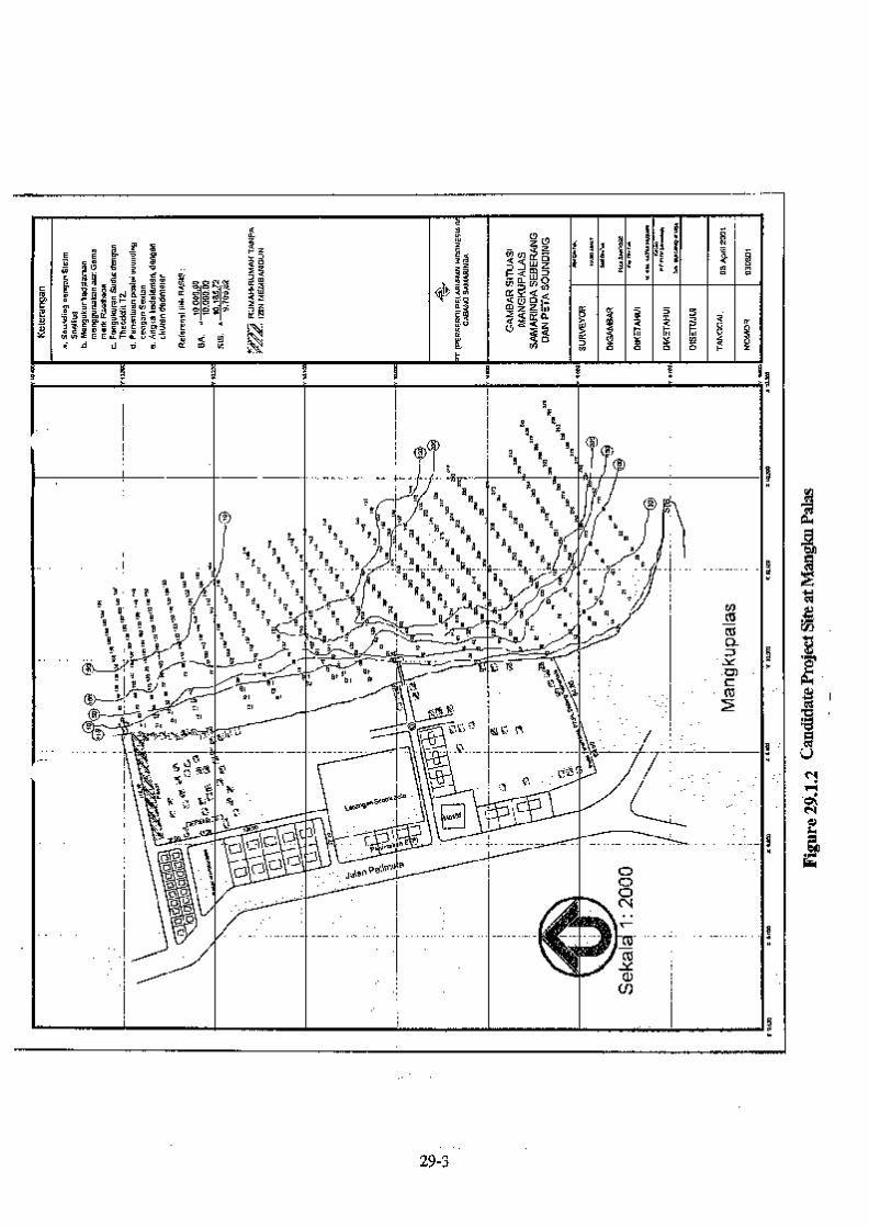
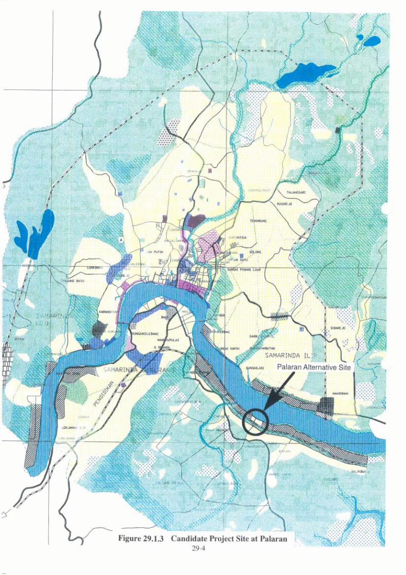
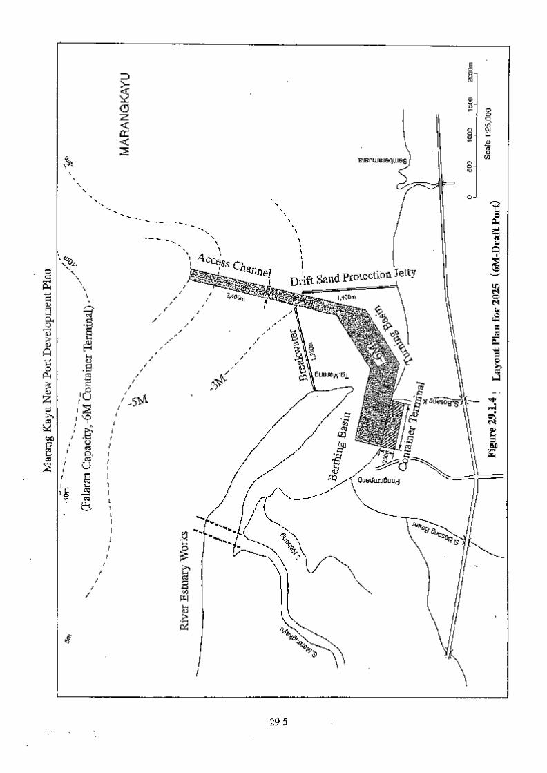
29-6
① Terminal The area for the proposed container terminal can be estimated with the following formulas. ・ Container Terminal Area = (Container yard area) / (Yard area ratio) = 14.7 ha (2025) ・ Container Yard Area = (Ground slots) / (Land use ratio) = 8.8 ha (2025) ・ Ground Slots = (Container volume) x (Dwelling time) / (Yard operation ratio) / 365 / (Stacking height) = 2,277 TEU (2025) where : Yard area ratio : 0.6 (CFS within the terminal) Land use ratio : 260 TEU / ha (RTG system) Dwelling time : 5 days Yard operation ratio : 0.6 Stacking height : 4 Container volume : 399,000 TEU / year (2025) ・ Depth of the terminal = (Terminal area) / (Quay length) = 196 m (2025) Considering the layout of container terminal facilities, the Team proposes 250 m (including the apron of the wharf) as the depth of the terminal area in 2025. Consequently, the container terminal area turns out to be 19 ha. ② CFS Assuming the depth of CFS as 40 m and the width of a bay as 8 m, the actual area will be 8,320 m2 in 2025. ③ Handling Equipment Taking into account the following factors, a RTG system is recommended for the yard operation. i) Linear quay alignment. ii) Reliability of equipment. iii) The terminal will be open to multiple users. iv) The terminal requires high stowing capacity to maximize the operational income.
In order to provide a quay-side productivity of 20 TEU/hour/berth, each berth needs to have a gantry crane. Each gantry requires two RTG and four yard tractors. c. Cost Estimation The cost estimation of a new container terminal at Marang Kayu is based on the following assumption. The construction cost of 6 m-draft container terminal at Marang Kayu is shown in Table 29.1.1.
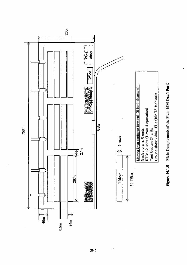
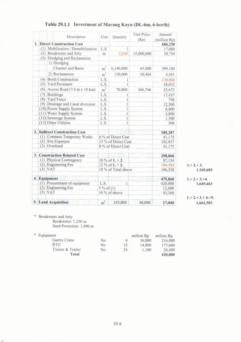
29-9
① A new container terminal site at Marang Kayu is chosen in the inner bay sheltered by the Marang Kayu Peninsula.
② A drift sand protection jetty is effectively functioned when the jetty is extended up to –3 m depth water area.
③ The width of a long access channel is designed to secure 1.5 * LOA for safety channel navigation of inland container vessels.
④ The river configuration of Sungai Marangkayu, a small river which is going down to the inner bay, is reconverted to the open sea in order to prevent from river soil sedimentation.
⑤ The unit price of breakwater construction at Marang Kayu is the same as actual results of breakwater construction at similar seaports in Indonesia.
⑥ The unit price of dredging cost at Marang Kayu is the same as the unit dredging cost at the Mahakam River and its estuary.
⑦ The unit price of wharf and yard construction at Marang Kayu is the same as the unit construction cost at Palaran, estimated by the Study Team.
2) 12 Meter-draft Container Port Plan a. Project Profile The layout plan for 2025 is shown in Figure 29.1.6. Main components of the plan are shown in Figure 29.1.7. The Study Team plans to create a new large-scale modern container terminal at Marang Kayu on condition that the port will not be buried under coastal drift sand when a breakwater is extended up to –3m depth water area. This plan is conceived in order to examine the possibility of a large-scale, deep sea port within the Samarinda port hinterland which is able to accommodate international container vessels. Therefore, the wharf draft of this container port is –12m, just the same water draft as a new container port at Kariangau, East Kalimantan, which was studied and proposed by the Asian Development Bank in November, 1996. 12 m-draft new container terminal plan also requires land acquisition, a large amount of capital dredging, long breakwater construction, river estuary works and long port access road. b. Container Terminal ① Terminal The area for the proposed container terminal can be estimated with the following formulas. ・ Container Terminal Area = (Container yard area) / (Yard area ratio) = 18.3 ha (2025) ・ Container Yard Area = (Ground slots) / (Land use ratio) = 11.0 ha (2025) ・ Ground Slots = ( Container volume ) x ( Dwelling time ) / ( Yard operation ratio ) / 365 / (Stacking height) = 2,850 TEUs (2025) where :
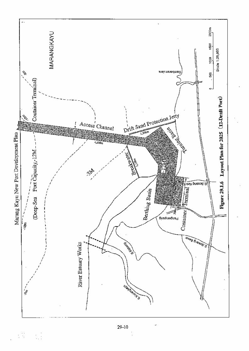
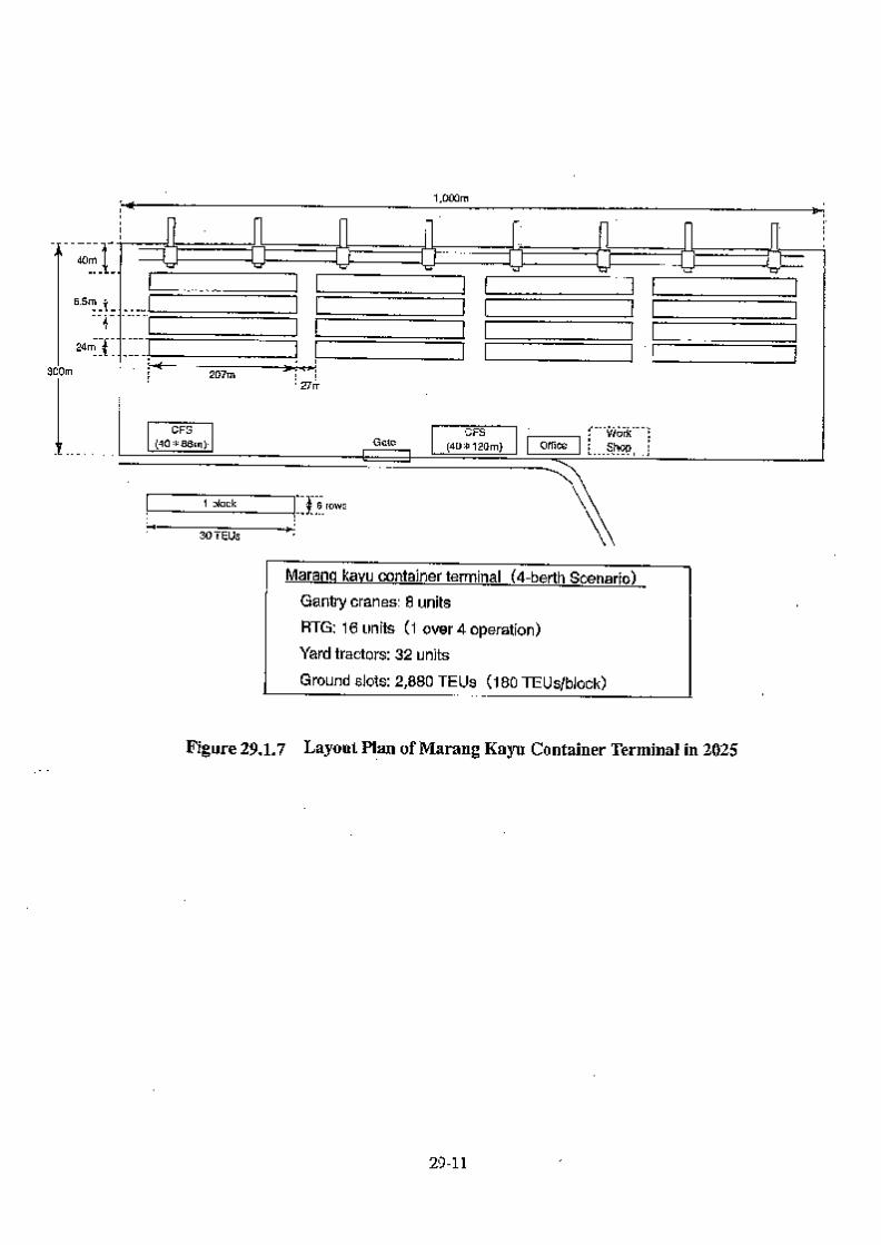
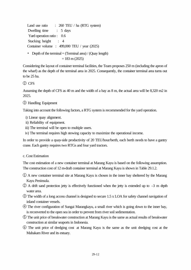
29-12
Land use ratio : 260 TEU / ha (RTG system) Dwelling time : 5 days Yard operation ratio : 0.6 Stacking height : 4 Container volume : 499,000 TEU / year (2025) ・ Depth of the terminal = (Terminal area) / (Quay length) = 183 m (2025) Considering the layout of container terminal facilities, the Team proposes 250 m (including the apron of the wharf) as the depth of the terminal area in 2025. Consequently, the container terminal area turns out to be 25 ha. ② CFS Assuming the depth of CFS as 40 m and the width of a bay as 8 m, the actual area will be 8,320 m2 in 2025. ③ Handling Equipment Taking into account the following factors, a RTG system is recommended for the yard operation. i) Linear quay alignment. ii) Reliability of equipment. iii) The terminal will be open to multiple users. iv) The terminal requires high stowing capacity to maximize the operational income. In order to provide a quay-side productivity of 20 TEU/hour/berth, each berth needs to have a gantry crane. Each gantry requires two RTGs and four yard tractors. c. Cost Estimation The cost estimation of a new container terminal at Marang Kayu is based on the following assumption. The construction cost of 12 m-draft container terminal at Marang Kayu is shown in Table 29.1.2. ① A new container terminal site at Marang Kayu is chosen in the inner bay sheltered by the Marang
Kayu Peninsula. ② A drift sand protection jetty is effectively functioned when the jetty is extended up to –3 m depth
water area. ③ The width of a long access channel is designed to secure 1.5 x LOA for safety channel navigation of
inland container vessels. ④ The river configuration of Sungai Marangkayu, a small river which is going down to the inner bay,
is reconverted to the open sea in order to prevent from river soil sedimentation. ⑤ The unit price of breakwater construction at Marang Kayu is the same as actual results of breakwater
construction at similar seaports in Indonesia. ⑥ The unit price of dredging cost at Marang Kayu is the same as the unit dredging cost at the
Mahakam River and its estuary.
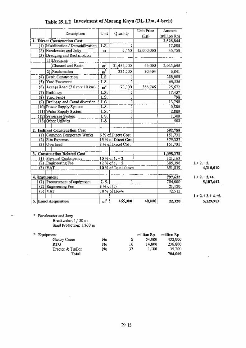
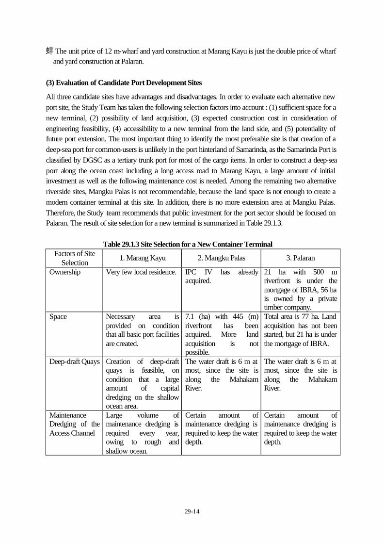
29-14
⑦ The unit price of 12 m-wharf and yard construction at Marang Kayu is just the double price of wharf and yard construction at Palaran.
(3) Evaluation of Candidate Port Development Sites All three candidate sites have advantages and disadvantages. In order to evaluate each alternative new port site, the Study Team has taken the following selection factors into account : (1) sufficient space for a new terminal, (2) possibility of land acquisition, (3) expected construction cost in consideration of engineering feasibility, (4) accessibility to a new terminal from the land side, and (5) potentiality of future port extension. The most important thing to identify the most preferable site is that creation of a deep-sea port for common-users is unlikely in the port hinterland of Samarinda, as the Samarinda Port is classified by DGSC as a tertiary trunk port for most of the cargo items. In order to construct a deep-sea port along the ocean coast including a long access road to Marang Kayu, a large amount of initial investment as well as the following maintenance cost is needed. Among the remaining two alternative riverside sites, Mangku Palas is not recommendable, because the land space is not enough to create a modern container terminal at this site. In addition, there is no more extension area at Mangku Palas. Therefore, the Study team recommends that public investment for the port sector should be focused on Palaran. The result of site selection for a new terminal is summarized in Table 29.1.3.
Table 29.1.3 Site Selection for a New Container Terminal Factors of Site
Selection 1. Marang Kayu 2. Mangku Palas 3. Palaran
Ownership Very few local residence. IPC IV has already acquired.
21 ha with 500 m riverfront is under the mortgage of IBRA, 56 ha is owned by a private timber company.
Space Necessary area is provided on condition that all basic port facilities are created.
7.1 (ha) with 445 (m) riverfront has been acquired. More land acquisition is not possible.
Total area is 77 ha. Land acquisition has not been started, but 21 ha is under the mortgage of IBRA.
Deep-draft Quays Creation of deep-draft quays is feasible, on condition that a large amount of capital dredging on the shallow ocean area.
The water draft is 6 m at most, since the site is along the Mahakam River.
The water draft is 6 m at most, since the site is along the Mahakam River.
Maintenance Dredging of the Access Channel
Large volume of maintenance dredging is required every year, owing to rough and shallow ocean.
Certain amount of maintenance dredging is required to keep the water depth.
Certain amount of maintenance dredging is required to keep the water depth.
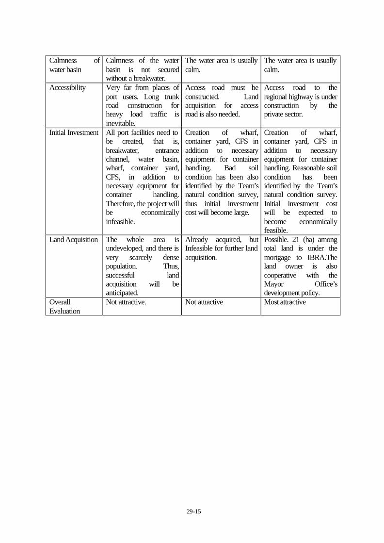
29-15
Calmness of water basin
Calmness of the water basin is not secured without a breakwater.
The water area is usually calm.
The water area is usually calm.
Accessibility Very far from places of port users. Long trunk road construction for heavy load traffic is inevitable.
Access road must be constructed. Land acquisition for access road is also needed.
Access road to the regional highway is under construction by the private sector.
Initial Investment All port facilities need to be created, that is, breakwater, entrance channel, water basin, wharf, container yard, CFS, in addition to necessary equipment for container handling. Therefore, the project will be economically infeasible.
Creation of wharf, container yard, CFS in addition to necessary equipment for container handling. Bad soil condition has been also identified by the Team’s natural condition survey, thus initial investment cost will become large.
Creation of wharf, container yard, CFS in addition to necessary equipment for container handling. Reasonable soil condition has been identified by the Team’s natural condition survey. Initial investment cost will be expected to become economically feasible.
Land Acquisition The whole area is undeveloped, and there is very scarcely dense population. Thus, successful land acquisition will be anticipated.
Already acquired, but Infeasible for further land acquisition.
Possible. 21 (ha) among total land is under the mortgage to IBRA.The land owner is also cooperative with the Mayor Office’s development policy.
Overall Evaluation
Not attractive. Not attractive Most attractive
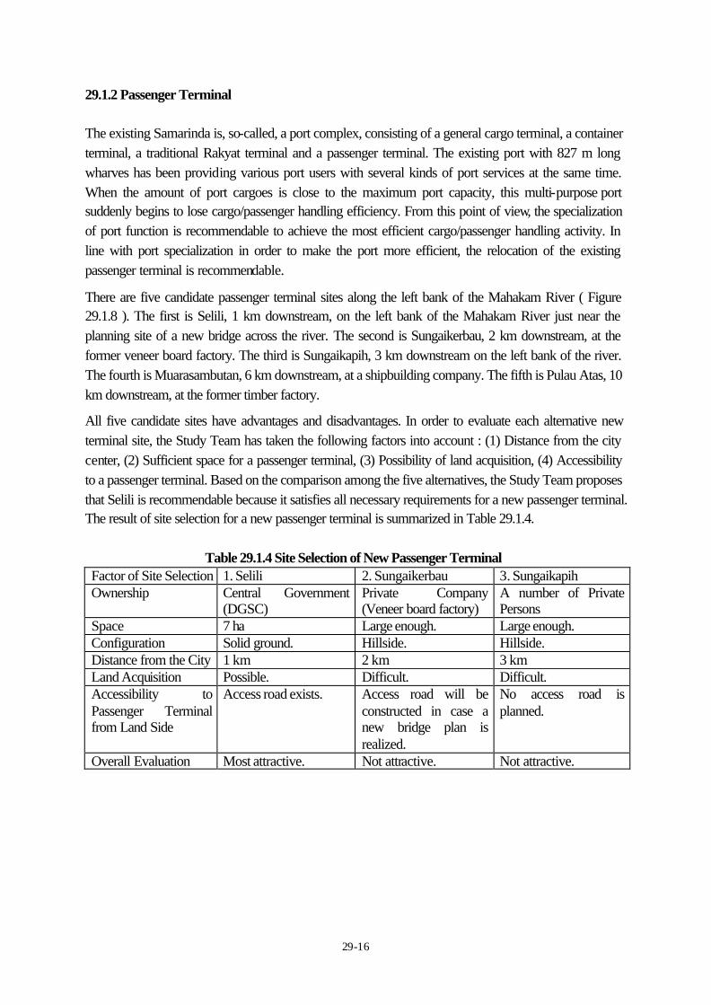
29-16
29.1.2 Passenger Terminal The existing Samarinda is, so-called, a port complex, consisting of a general cargo terminal, a container terminal, a traditional Rakyat terminal and a passenger terminal. The existing port with 827 m long wharves has been providing various port users with several kinds of port services at the same time. When the amount of port cargoes is close to the maximum port capacity, this multi-purpose port suddenly begins to lose cargo/passenger handling efficiency. From this point of view, the specialization of port function is recommendable to achieve the most efficient cargo/passenger handling activity. In line with port specialization in order to make the port more efficient, the relocation of the existing passenger terminal is recommendable. There are five candidate passenger terminal sites along the left bank of the Mahakam River ( Figure 29.1.8 ). The first is Selili, 1 km downstream, on the left bank of the Mahakam River just near the planning site of a new bridge across the river. The second is Sungaikerbau, 2 km downstream, at the former veneer board factory. The third is Sungaikapih, 3 km downstream on the left bank of the river. The fourth is Muarasambutan, 6 km downstream, at a shipbuilding company. The fifth is Pulau Atas, 10 km downstream, at the former timber factory. All five candidate sites have advantages and disadvantages. In order to evaluate each alternative new terminal site, the Study Team has taken the following factors into account : (1) Distance from the city center, (2) Sufficient space for a passenger terminal, (3) Possibility of land acquisition, (4) Accessibility to a passenger terminal. Based on the comparison among the five alternatives, the Study Team proposes that Selili is recommendable because it satisfies all necessary requirements for a new passenger terminal. The result of site selection for a new passenger terminal is summarized in Table 29.1.4.
Table 29.1.4 Site Selection of New Passenger Terminal Factor of Site Selection 1. Selili 2. Sungaikerbau 3. Sungaikapih Ownership Central Government
(DGSC) Private Company (Veneer board factory)
A number of Private Persons
Space 7 ha Large enough. Large enough. Configuration Solid ground. Hillside. Hillside. Distance from the City 1 km 2 km 3 km Land Acquisition Possible. Difficult. Difficult. Accessibility to Passenger Terminal from Land Side
Access road exists. Access road will be constructed in case a new bridge plan is realized.
No access road is planned.
Overall Evaluation Most attractive. Not attractive. Not attractive.

29-17
Factor of Site Selection 4. Muarasambutan 5. Pulau Atas Ownership Private Company.
(Shipbuilding company)
Municipal Government. (Former log factory)
Space Large enough. 10 ha Configuration Flat Land. Flat Land. Distance from City 6 km 10 km Land Acquisition Difficult. Possible. Accessibility to Passenger Terminal from Land Side
No access road is planned.
Located adjacent to the highway. Short access road is needed.
Overall Evaluation Not attractive. Attractive.
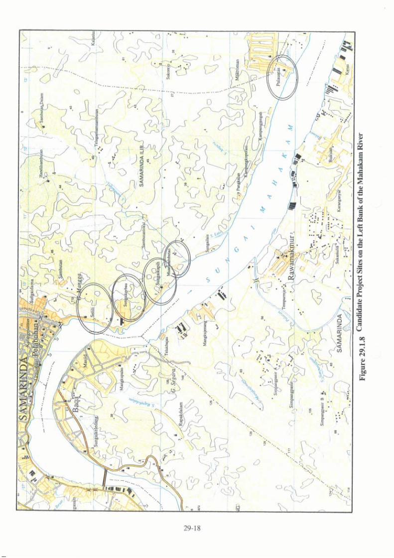
29-19
29.2 Administrative Aspects 29.2.1 Issues arising from Creation of New Samarinda Port (1) Review and Creation of Port Working Area and Port Interest Area Samarinda Port, which is located about 60 km upstream from the mouth of the Mahakam River, is managed by IPC IV Samarinda branch office. Samarinda is a busy port handling a lot of containers. According to the long-term demand forecast, the capacity of the present port facilities will not be sufficient to respond to the future demand. For this reason, the Study Team proposed a new container terminal at Palaran area opposite to the present port. After this land is acquired, port working area will need to be established. An access road will be needed as well. Samarinda ADPEL is responsible for the safe navigation along the Mahakam River. The port working area and the port interest area in this river and around its river mouth should be reviewed to realize the best sharing scheme of dredging costs among the concerned parties. (2) Relocation of Port related Offices in Samarinda Port ADPEL office, port related offices and a passenger terminal are located in the existing Samarinda Port. The passenger terminal will need to be relocated to make room for the cargo handling in the existing terminal. The timing of the relocation needs careful attention as the passenger terminal was constructed as recently as 1995 and is still in good condition. It is necessary to quickly relocate the ADPEL office and the other buildings out from this narrow area. The existing IPC IV Samarinda branch office is located outside the port working area.
29-20
29.3 Engineering Aspects
The existing Samarinda port has wharves of 700 m length and about 30 m land depth. The land area of the existing port is surrounded by the city and the main road of Samarinda, and thus has no space for the port expansion. To cope with the growing volume of the cargo traffic and ship calls, new sites for the port development (Marang Kayu, Mangkupalas and Palaran) were recommended and the condition of each site was studied from engineering aspects as described below.
29.3.1 Marang Kayu
(1) Geophysical Features
Marang Kayu is located on the coast of Selat Makassar about 50 km from central Samarinda along the regional semi-arterial road (refer to Figure 29.1.1).
Marang Kayu was a candidate site of deep-sea port development that supersedes the existing Samarinda port recommended by the port authority of Samarinda.
The notable geographical features of the Marang Kayu site are the well grown sand-spit and the small, shallow bay (the water depth is assumed as LWS-2 to -3 m at the deepest) sheltered by the sand-spit. The surrounding area is swampy low land.
(2) Wave and Littoral Sand Drift
Based on the configuration of the sand-spit, there is dominative littoral sand drift in the southerly direction.
If a deep-sea harbour basin is secured outside of the sand-spit, - A set of breakwaters will be necessary to secure the calmness of the basin from the
waves of Selat Makassar, and - A set of sand barriers will be necessary to prevent the inflow of sand into the basin.
Or if a deep-sea harbour basin is secured in the sheltered small bay, - A large amount of capital dredging work will be necessary, and - A large volume of maintenance dredging of the basin and access channel will be
necessary since the abundant littoral sand drift is assumed.
(3) Access
Access from the present Samarinda city area to Marang Kayu will take about 2 to 3 hours by road.
The condition of the road needs improvement to cope with container traffic: namely, improvement of width and pavement of the road and acquisition of the land area for the construction of the approaching road to the Marang Kayu site.
29-21
(4) Disadvantage of Marang Kayu
East Kalimantan province already has a development project for deep-sea port at the Kariangau district in Balikpapan.
The Kariangau site is endowed with a sheltered water area with deep-water conditions over 15 m. The Kariangau container terminal was planned with -12.0 m quay (LWS) in design depth, and the corresponding volume of the capital dredging was planned of 900,000 m3 and reclamation of 190,000 m3 (Short Term Development).
Balikpapan is located about 120 km from Samarinda and the two regions are connected with a well-conditioned arterial road. The two regions have a very close relationship.
The Kariangau site has the advantage of deep-sea port development rather than Marang Kayu to meet the demands of the time and to cope with the modernization and containerization of the sea transport. The project will be implemented in the near future after the recovery of the Indonesian economy.
The conclus ion is that the Marang Kayu site does not have the particular advantage of deep-sea port development that supersedes the existing Samarinda port
29.3.2 Mangkupalas
(1) Present Situation
The site of Mangkupalas is located on the right bank of Sungai Mahakam and is about 450 m in extension along Sungai Mahakam and 150 m in land depth. The premises of 7.2 ha were purchased by the Ministry of Communication in 1974 and were transferred to IPC4 later (refer to Figure 29.1.2 Mangkupalas).
There are about 100 houses and small stores remaining on the premises, and an agreement has been made to move them out of this area after the port construction is decided (IPC4).
Access is about 14 km from the existing Samarinda Port via Mahakam Bridge and the access road (provincial) is in the process of improvement to two lanes and 15 m width.
(2) Advantage
This site has the extension of over 400 m along shoreline. Land acquisition has been concluded already.
(3) Disadvantage
The shoreline of site has been eroded about 30 m by the flood water of Mahakam River for 20 years from 1981 and displays a very steep riverbed profile in front of the site.
In order to secure the stability of the port facilities along the shoreline, construction of
29-22
some shore protection works or revetment and a rather large expense will be inevitable.
This site lacks depth of land as a container terminal. It will be necessary in the near future to secure another land area for container marshalling yard and empty van pool. This site lacks the space for the further expansion after the “long term” development.
29.3.3 Palaran
(1) Present Situation
The site is located on the right bank of Sungai Mahakam and belongs to Desa Palaran / Kecamatan Palaran / Kota Samarinda (see Figure 29.1.3).
Access is about 20 km from the existing Samarinda Port via Mahakam Bridge and the construction of access road (about 600 m in extension, cutting through a hill of 15 m height) will be needed.
(2) Advantage
This site has the extension of over 500 m along shoreline. Water depth about 15 m will be secured nearby from the shoreline. Bathymetric survey in front of the proposed quay will be carried out in the subsequent stage of this study.
(3) Disadvantage
The land area consists of 21 ha of riverside premises and 53 ha of hillside premises. A bankrupt timber factory (PT Samarinda Timber, established in 1980) remains and is still partially running with 253 employees.
Land acquisition and the problems of compensation and employment have not been concluded. To secure the land area for port development and close down the existing factory, study about the problem of compensation and employment is necessary.
This site has experience to be inundated in 1987 and 1994 by the flood of Sungai Mahakam. In order to secure the access road and safety against inundation, some large amount of earthwork will be inevitable.