Embed Size (px)
Citation preview

27 February, 2009 Space Systems Research Frontiers Course 1
Satellite Receiving Station OverviewSatellite Receiving Station Overview
Neil Lonie
Satellite Receiving Station
Space Technology Centre
University of Dundee
27 February, 2009 Space Systems Research Frontiers Course 2
BackgroundBackground
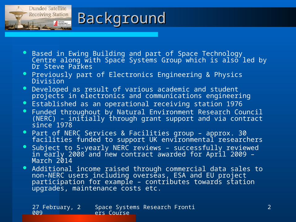
Based in Ewing Building and part of Space Technology Centre along with Space Systems Group which is also led by Dr Steve Parkes
Previously part of Electronics Engineering & Physics Division Developed as result of various academic and student projects in
electronics and communications engineering Established as an operational receiving station 1976 Funded throughout by Natural Environment Research Council
(NERC) – initially through grant support and via contract since 1978 Part of NERC Services & Facilities group – approx. 30 facilities
funded to support UK environmental researchers Subject to 5-yearly NERC reviews – successfully reviewed in early
2008 and new contract awarded for April 2009 – March 2014 Additional income raised through commercial data sales to non-NERC
users including overseas, ESA and EU project participation for example – contributes towards station upgrades, maintenance costs etc.

27 February, 2009 Space Systems Research Frontiers Course 3
Overview of ActivitiesOverview of Activities
Main activities are Earth Observation data reception, archiving and distribution to support environmental research – not usually directly involved in data analysis/research
Provide UK researchers and other potential users with access to data and imagery – generally via website and internet delivery, but also on tape, DVD etc. or in hardcopy printed form
Raw received satellite data are processed to and distributed in standard formats widely used by the research community, e.g. NOAA Level 1b
Imagery from individual spectral bands can also be extracted from raw data and provided in standard image file formats and map projections
Higher level processing for scientific data products and data analysis is generally undertaken by users and/or other facilities
27 February, 2009 Space Systems Research Frontiers Course 4
Staff and Working ArrangementsStaff and Working Arrangements
Staff expertise is generally in computing and engineering• Steve Parkes (Director) – Overall responsibility• Neil Lonie (Manager) – Oversee operations – e.g. staff, user enquiries, NERC
contact, admin, finance, reporting, equipment procurement, installation and maintenance, data reception/archiving arrangements
• Andrew Brooks (Software/Systems Manager) – Software development and maintenance, systems admin and specification, data processing/archiving etc.
• Jon Bowyer (Software/Systems Specialist) – as above• Paul Crawford (Electronics/Communications Engineer) – Hardware/software
development and maintenance for antenna control and RF receiver systems• Drew Doig (Technician) – Shift Operator• Bruce Isabella (Technician) – Shift Operator• Les Moonlight (Technician) – Maintenance and Operator cover
Station operates on a 24/7 basis each day of the year Manned each day – typically between 8 am and 10 pm Only downtime periods occur during extended mains power failures –
very rare – UPS systems maintain reception operations for ~ 2 hours
27 February, 2009 Space Systems Research Frontiers Course 5
Data Received and the ArchiveData Received and the Archive
Receive and archive data from various EO satellites – mainly polar orbiting satellites with direct data broadcast capability
• NOAA-AVHRR series Nov. 1978 – present
• Nimbus 7 – CZCS Aug. 1979 – Jun. 1986
• OrbView2-SeaWiFS Sep. 1997 – 2005
• Terra/Aqua-MODIS Apr. 2000 – present
Currently receive data from 25-30 polar satellite passes per day Full polar archive comprises over 120,000 passes at present Data also received from various geostationary weather satellites giving
up-to-date full global coverage imagery• Meteosat – Europe Archived 2002 - present
• IODC – Europe (Indian Ocean coverage) Archived 2005 - present
• GOES-East – United States Archived 2006 - present
• GOES-West – United States Archived 2006 - present
• MTSAT – Japan Archived 2006 - present

27 February, 2009 Space Systems Research Frontiers Course 6
Geographical CoverageGeographical Coverage
Polar Orbiting Satellites
Dundee coverage footprint for polar orbiting satellites such as the NOAA series , Terra and Aqua
27 February, 2009 Space Systems Research Frontiers Course 7
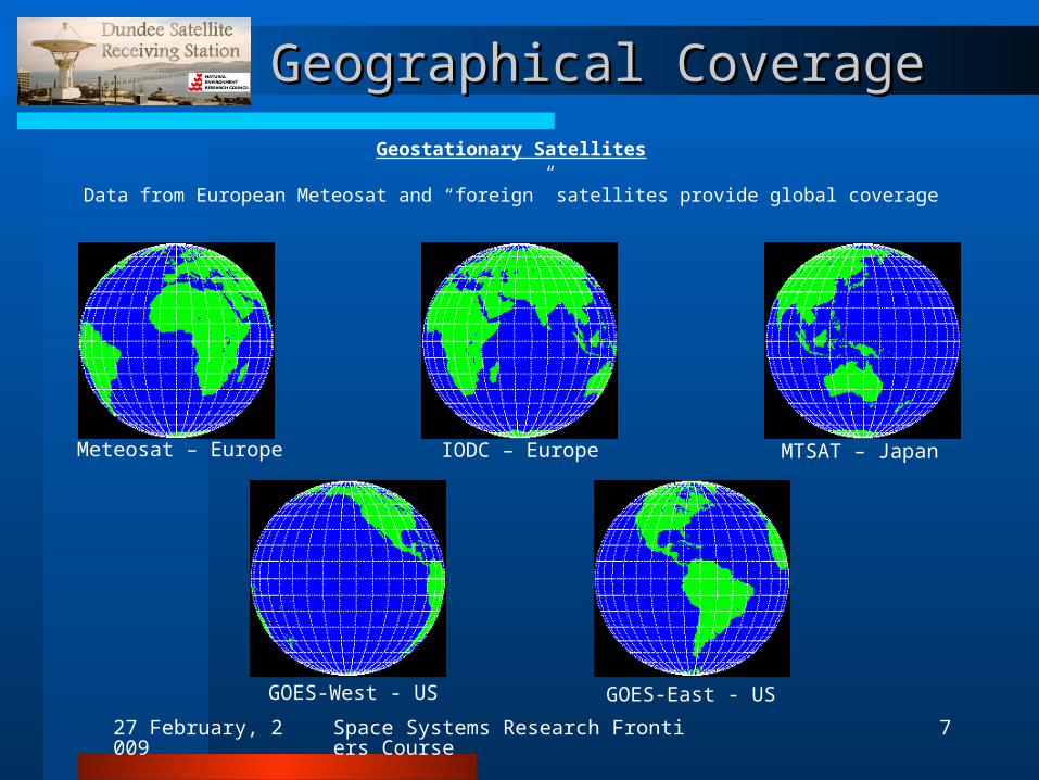
Geographical CoverageGeographical Coverage
Geostationary Satellites
Data from European Meteosat and “foreign” satellites provide global coverage
Meteosat – Europe
GOES-West - US
MTSAT – JapanIODC – Europe
GOES-East - US
27 February, 2009 Space Systems Research Frontiers Course 8
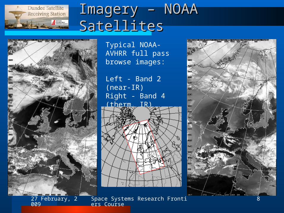
Imagery – NOAA SatellitesImagery – NOAA Satellites
Typical NOAA-AVHRR full pass browse images:
Left - Band 2 (near-IR) Right - Band 4 (therm. IR)
Below - pass coverage
27 February, 2009 Space Systems Research Frontiers Course 9
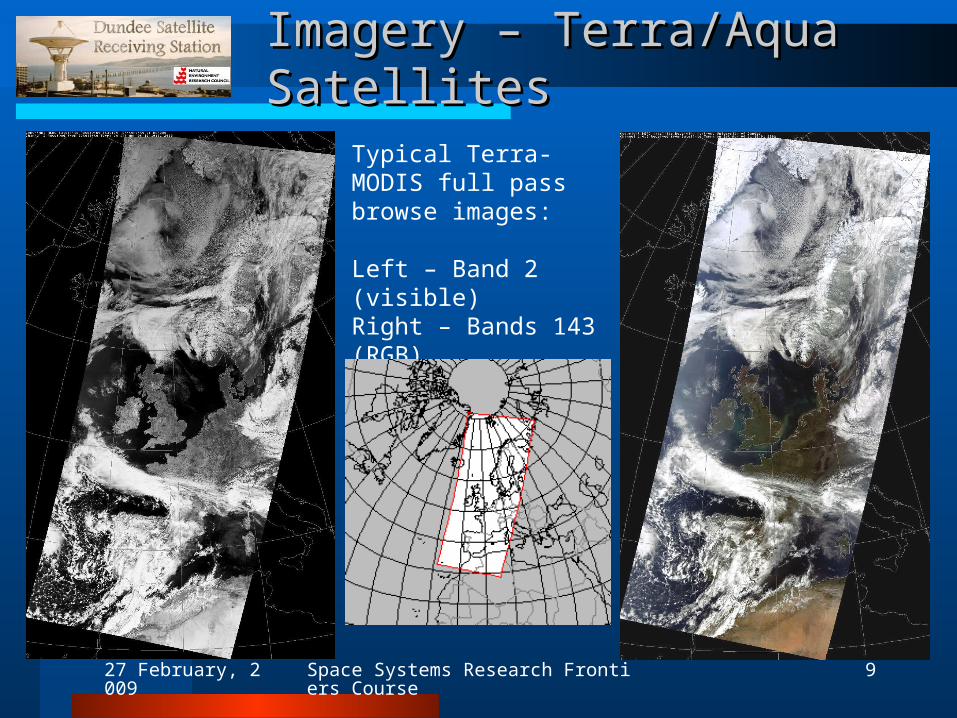
Imagery – Terra/Aqua SatellitesImagery – Terra/Aqua Satellites
Typical Terra-MODIS full pass browse images:
Left – Band 2 (visible)Right – Bands 143 (RGB)
Below - pass coverage
27 February, 2009 Space Systems Research Frontiers Course 10
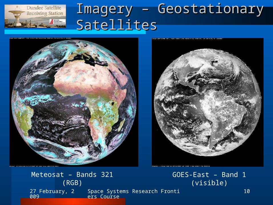
Imagery – Geostationary SatellitesImagery – Geostationary Satellites
Meteosat – Bands 321 (RGB) GOES-East – Band 1 (visible)
27 February, 2009 Space Systems Research Frontiers Course 11
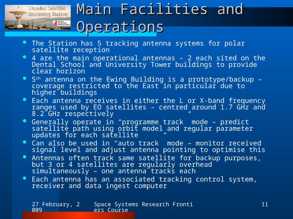
Main Facilities and OperationsMain Facilities and Operations
The Station has 5 tracking antenna systems for polar satellite reception 4 are the main operational antennas – 2 each sited on the Dental
School and University Tower buildings to provide clear horizon 5th antenna on the Ewing Building is a prototype/backup – coverage
restricted to the East in particular due to higher buildings Each antenna receives in either the L or X-band frequency ranges used
by EO satellites – centred around 1.7 GHz and 8.2 GHz respectively Generally operate in “programme track” mode – predict satellite path
using orbit model and regular parameter updates for each satellite Can also be used in “auto track” mode – monitor received signal level
and adjust antenna pointing to optimise this Antennas often track same satellite for backup purposes, but 3 or 4
satellites are regularly overhead simultaneously – one antenna tracks each
Each antenna has an associated tracking control system, receiver and data ingest computer

27 February, 2009 Space Systems Research Frontiers Course 12
Main Facilities and OperationsMain Facilities and Operations
After ingest, data are transferred to servers for low level processing, archiving and web access for users
Also transferred in real time to Plymouth Marine Lab for high level processing
Data are always archived offline – on either CD or LTO (400 Gbyte) tape at present – copies are sent off-site for secure storage
3 storage servers provide around 12 terabytes of online storage They hold online copies of the entire AVHRR and SeaWiFS polar
archives at full resolution for immediate user access via the web The Station also has 2 fixed position antenna systems for reception of
geostationary satellite data In-house capability – most Station systems including antennas,
control software/hardware, receivers, data ingest and processing software are designed, developed and maintained by staff
27 February, 2009 Space Systems Research Frontiers Course 13
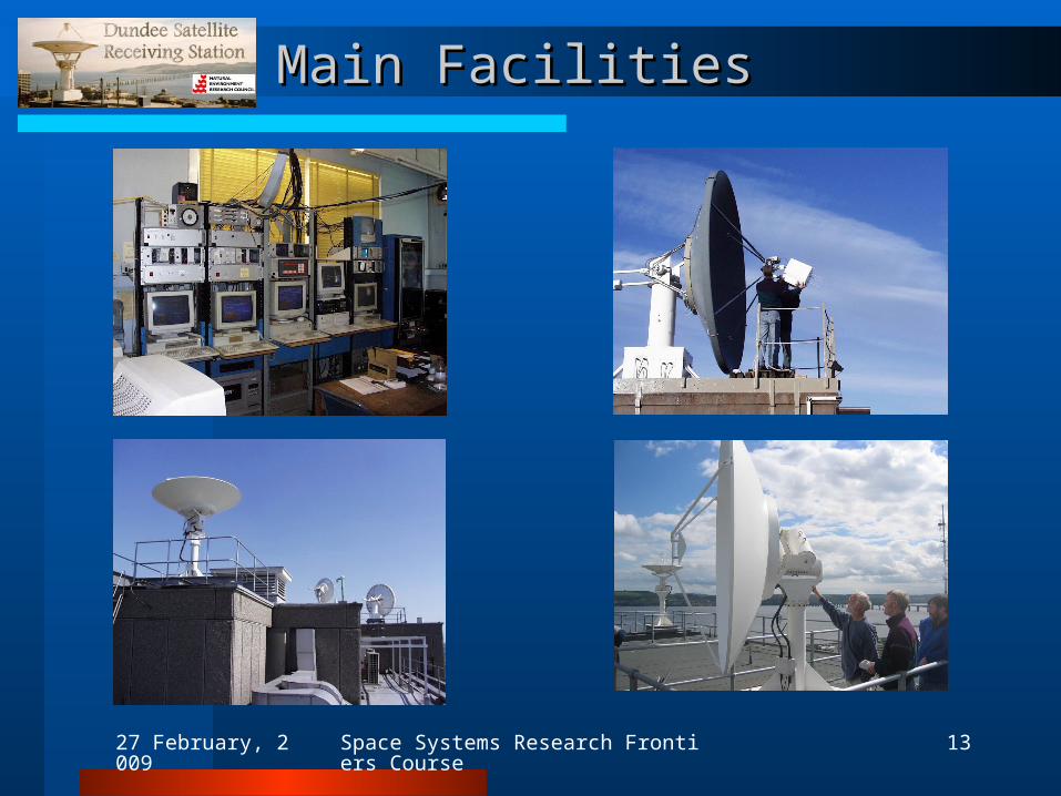
Main FacilitiesMain Facilities
27 February, 2009 Space Systems Research Frontiers Course 14
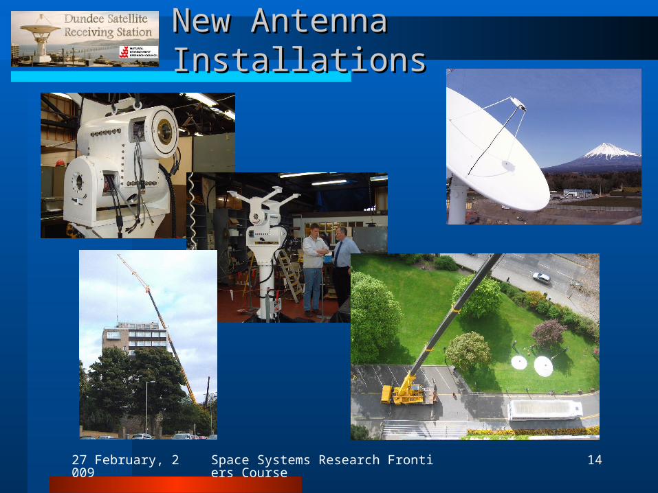
New Antenna InstallationsNew Antenna Installations
27 February, 2009 Space Systems Research Frontiers Course 15
User CommunityUser Community
User community extends across most environmental science areas – e.g. marine, atmospheric, Earth, terrestrial, polar
Application areas include physical and biological oceanography, meteorology, hydrology, volcanology, snow/ice cover, land use, agriculture
Users within NERC scheme include:– Research centres such as National Oceanography Centre (Southampton), Plymouth Marine Lab, Centre for
Ecology and Hydrology– NERC EO centres of excellence such as Centre for Observation of Air-Sea Interactions & Fluxes (CASIX)– Individual researchers and groups within environmental science departments of many UK HEIs
Users outwith NERC scheme and generally paying for access to data have included:– UK organisations such as Ministry of Defence and the Met Office– ESA and EU funded projects– NASA, NOAA and NATO projects– Research centres and HEIs throughout Europe– Commercial remote sensing companies
Data requirements vary from a few scenes to several thousand scenes for major projects Website provides free access to browse images of the entire archive and geostationary images for
anyone who registers – Users range from researchers, students, national weather services, operational support activities (e.g. flight
planning) to personal interest– Over 300,000 user registrations since site was launched– Around 10 million free image downloads annually
27 February, 2009 Space Systems Research Frontiers Course 16
Dundee-Plymouth PartnershipDundee-Plymouth Partnership
Largest proportion of users are from a marine background due to close partnership with Remote Sensing Group at Plymouth Marine Lab.
Plymouth RSG is also NERC funded – provides higher level EO products mainly derived from Dundee data
Primarily focus on marine products due to local expertise – can also provide standard products for atmospheric and terrestrial applications and volcano monitoring, for example
Products include– Geo-referenced sea-surface temperature, land brightness temperature and
vegetation index from AVHRR– Chlorophyll and other ocean colour properties from SeaWiFS– Ocean colour and cloud products from MODIS– Single image products, weekly/monthly/other composites are available– Products are supplied in near-real time or from the archive
Dundee and Plymouth now operate a linked facility within the NERC set up – NERC Earth Observation Data Acquisition and Analysis Service (NEODAAS)
27 February, 2009 Space Systems Research Frontiers Course 17
Supported ActivitiesSupported Activities
Individual student and academic research projects to major NERC programmes and Centres of Excellence are supported
A key activity with Plymouth is near real-time operational support of research cruises – e.g. 16 major research cruises supported in 2005/06 spanning a total of 354 cruise days
NERC-CEH Phenology observatory – provided MODIS data for this development project to monitor seasonal vegetation for long-term trends which may indicate climate change
ESA CONTRAILS – partnered DLR and KNMI in project to assess extent of aircraft contrails and demonstrate a monitoring service – processed ~10000 archive satellite passes and delivered contrail detection maps for analysis
NASA SeaWiFS ocean colour project – provided all received SeaWiFS data for 8 years from launch in 1997 (~7500 passes)
EU MARS – recently delivered ~7500 AVHRR passes to project partners for use in this agriculture monitoring project to support EU policy
For 2008 review, NEODAAS identified over 600 scientific publications supported by our data over previous 5 years – 270 were refereed papers – others were non-refereed, conference presentations, posters, dissertations etc.
Dundee images also used regularly in books, magazines, newspapers, TV etc.
27 February, 2009 Space Systems Research Frontiers Course 18
Forward LookForward Look
Additional antennas installed on Tower Building in recent years to receive from more satellites – systems such as receivers continue to be upgraded to improve flexibility
Aim to maintain support for our existing satellites and follow on missions – e.g. MetOp and NPP/NPOESS joint European/US polar system
Look to gain access to more EO satellites – e.g. Indian and Chinese and other European satellites
Possible support for developers of low cost satellites with no ground station infrastructure
Provide online storage for entire Dundee archive – for better archive management and to allow processing of long time-series data
Develop NEODAAS partnership further – e.g. operate Plymouth processing systems at Dundee for faster product delivery for NRT applications
Improve support for science areas other than marine through Plymouth partnership or new partnerships – e.g. the CEH Phenology project
Implement partner/user developed processing algorithms at Dundee for efficient data processing – particularly long time-series data sets