Embed Size (px)
Citation preview
266 THE AMERICAN ALPINE JOURNAL 1986
South Terong and the South Rimo Glaciers. I travelled up the Shelkar Chorten Glacier, climbing Chorten Peak (6050 meters, 19,849 feet; 7 kms east of Base Camp) before crossing Shelkar Co1 and the South Terong Glacier to climb Ngabong Terong (6180 meters, 20,276 feet; 8 kms southeast of Base Camp). Finally on July 26 and 27, the remaining members ferried loads back down the Terong valley and across a cliff rope traverse, avoiding the now dangerously flooded river crossing, and back down the Siachen snout to the Nubra valley. Henry Osmaston carried out interesting glaciological studies.
STEPHEN VENABLES, Alpine Climbing Group
Nomenclature in the Terong Valley. The following names have been pro- posed to the Survey of India. Sondhi = a sudden beautiful appearance. Sund- brar = a beautiful place, There is a place by the name of Sundbrar in Baltistan. Kashmiri Brahmins and Hindus along with several thousand people used to gather at this place on a certain day in June. They would worship the goddess Laxmi and wait for the rising of water and pray for it to appear. At an appointed time a stream would fill the basin and the multitude would shout, “Sondhi!” This phenomenon portrays Hindu rituals deep inside Muslim Baltistan. Lharimo = holy, painted mountain. Doab = meeting place of two waters. Sajna = boat. In Balti philosophy this is a special boat which carries one to Heaven. Saigat = leopard’s leap. This peak tilts (leaps) toward the giant Rimo peaks. Chorten = the Buddhist symbol. Ngabong Terong. Ngabong = Bacterian camel, the fa- mous double-humped camel of Yarkand. A few are still seen in the Nubra valley. Terong is from Te = that and Rong = valley. Siab Chushku. Siab = meeting place of three waters (North and South Terong and Shelkar Chorten Glaciers) Chushku = temporary camp. Rimo = striped mountain. Terong and Rimo are officially accepted names. It should be noted that Indira Co1 was named in 19 12 by the Workmans after the goddess Laxmi. With recent political developments there is a misconception that this col, now the northernmost point of India, is named for the late Prime Minister, Mrs. Indira Gandhi, but of course this is not true.
HARISH KAPADIA, Himalayan Club
K12, Saltoro Group, 1984. Our Indian Army expedition climbed K12 (7428 meters, 24,371 feet) on October 17, 1984. The summiters were Nb/Sub. N.D. Sherpa, Hav. Rattan Singh Rana and Hav. Nima Sherpa. The route was along the west ridge.
PREM CHAND, Lieutenant Colonel, Indian Army
Pakistan
K2. We left Dassu on May 7. Our approach march took 13 rather than 11 days because of bad weather. We worked in two separate groups. Nicole
CLIMBS AND EXPEDITIONS, I985 267
Niquille, Marcel Riiedi, Norbert Joos and Jacques Grandjean prepared the route on the Abruzzi Ridge, placing Camps I, II and III at 6150, 6800 and 7400 meters. Grandjean had altitude problems and could not go above Camp II. Pierre Morand, Jean Troillet and I worked on a new route on the south face alpine-style after acclimatization to 6400 meters on Broad Peak. The first attempt on the south face reached 6400 meters but we were turned back by bad weather. On the second attempt we got to 6700 meters on the first day where we made a snow cave. The next day we got to 7000 meters but encountered deep snow. Because of avalanche danger, we descended on June 7 in a snowstorm. It snowed for several days. On June 13 Riiedi and Joos left for Camp I. On the 14th Niquille, Troillet and I went to the west side of K2 to see the possibilities on the southwest buttress. That same day Ruedi and Joos radioed from Camp II. The weather turned bad again. We were worried as we had no radio contact with Joos and Riiedi through the 18th. We feared the worst but suddenly at six P.M. on the 19th we received a radio message. They had made it as the first Swiss to the summit. We others decided to try the Abruzzi Ridge. In cloudy weather on June 20 Niquille, Troillet, Morand and I left Base Camp at four A.M. The new snow was already steep at 5700 meters. We got to Camp I at nine A.M. Grandjean had altitude problems and decided that he would descend when we met Ruedi and Joos, but they did not appear. It snowed all night but cleared at dawn. Finally the very exhausted pair appeared. On June 18 they had left Camp IV at 7940 meters for the summit at six A.M., but snow conditions were very bad. They climbed until four P.M. when at 8300 meters they made a snow cave for a bivouac without sleeping bags or stove. They reached the summit the next morning at 10:30. They climbed slowly down to Camp IV for the night. On the 20th Joos had to descend to Camp II on frozen feet and was snowblind; Riiedi had also suffered frostbite. Grandjean escorted them down; Joos had to be carried on the glacier. Three days after they reached Base Camp, they were evacuated by helicopter. We set out and got up to Camp II at noon. In doubtful weather on June 22 we struggled through deep snow to Camp III and the next day plowed to Camp IV. After waiting out a day of storm, we descended to Base Camp. On July 4 Niquille, Troillet, Morand and 1 left at three A.M., followed an hour later by a four-man French team. On excellent snow we went that same day to Camp II. Perfectly acclimatized, we got there by one P.M. A Japanese team was advancing at the same time, but much more slowly and with more material than I could imagine. At dawn on the 5th we set out on what was the hardest day of the climb because of the long, steep rock section. The snow became very deep. We got to Camp III at eleven A.M. At nine P.M. in the windy night Niquille, Morand, Troillet, Frenchman Eric Escoffier and I left camp but at 7600 meters Nicole Niquille recognized the beginning of a phlebitis and so she turned back. We got to the site of Camp IV at one A.M. but found the camp had been swept away by an avalanche. We couldn’t heat drinks or cook. At dawn we reached a rather steep couloir leading to the “Bottle Co1 .” The snow became very deep and there were windslabs. It took us five hours to climb the last 400 meters. We descended to Camp III and got to Base Camp on the 7th. But the “Queen of the
268 THE AMERICAN ALPINE JOURNAL I986
Mountains” was to strike again. The day after our victory, one of the French- men, Daniel Lacroix was to disappear at about 8400 meters on the descent.
ERHARD LORETAN, Club Alpin Suisse
K2. Our 16-member expedition was led by Kazuo Tobita. We reached our provisional Base Camp at 5200 meters on June 10. Then we carried our loads ourselves and moved Base Camp to 5500 meters at the base of the Abruzzi Ridge, which we set up on June 20. It took almost one month to set up Camp I at 6250 meters, Camp II at 6800 meters above House’s Chimney and Camp III at 7400 meters. On July 18 Noboru Yamada, Kazunari Murakami and I placed Camp IV at 7840 meters. However, as the weather was terrible, we were forced to go down to Base Camp. After two days of waiting for clear weather, we same three moved to Camp II and the next day to Camp IV. On July 24 we left Camp IV at 2:30 A.M. and climbed up the shoulder. Then we climbed the rocky couloir which led us to the bottom of the hanging seracs. The deep snow was troublesome as we passed through the seracs on the left side. Though tempo- rarily stopped by the weather, we reached the summit at 1:40 P.M. Murakami and I used oxygen. On July 25 six other members attempted to reach the summit from Camp IV but gave up at 8000 meters because of heavy snow and wind.
KENJI YOSHIDA, Himalayan Association of Japan
Broad Peak. A six-man party was organized by the Pakistani Army School of Mountain Warfare and Physical Training which successfully climbed Broad Peak. Three camps were placed along the normal route. On July 30 the summit team left Camp III at 7250 meters and moved up to 7700 meters where they bivouacked below the col. The next morning they set off at 7:30 and reached the top at 3:15 P.M. Leader Major Rayyaz Hussain, Major Zahid Mahmood and Captain Jawad Pirzada were the summiters.
J~ZEF NYKA, Editor, Taternik, Poland
Broad Peak Attempt. After reaching Base Camp at 4850 meters on August 4, we had five days of snowfall. From August 10 to 14 we ferried supplies to 6000 meters and kept on to the summit ridge at 7950 meters, about 100 meters from the top before the weather turned bad. Second, third and fourth attempts, which reached 7800, 7300 and 7300 meters, were all turned back by bad weather. We helped Wanda Rutkiewicz search for her friend, Barbara Kozlowska, who was drowned in a glacial stream below Broad Peak and then helped to bury her.
LILIANE and MAURICE BARRARD, Club Alpin Fraqais
CLIMBS AND EXPEDITIONS, I985 269
Broad Peak Attempt and Tragedy. Broad Peak was attempted by Polish women Wanda Rutkiewicz and Barbara Kozlowska and Swiss Stephane Schaffter. They established camps at 6550 and 7200 meters. The weather was continuously bad. On August 18 Rutkiewicz climbed alone from Base Camp at 5000 meters directly to Camp II and the next day got to 7750 meters, close under the col. Shortly before, Kozlowska had descended solo from 7000 meters to Base Camp. While crossing a glacial stream, she tumbled into the impetuous water and was drowned.
J~ZEF NYKA, Editor, Taternik. Poland
Broad Peak Attempt. We were Andreas Miiller, Claus Coester, Edi Furrer, Felix Waltert, Armin Krummenacher, Peter Briitsch, Kudi Weibel and I as leader. First we fixed rope where there was steep bare ice. Then the weather changed and we had wind, snowfall and avalanches. On June 4 we reached 7000 meters, where we were stormbound for two days. So much snow fell that we were lucky to be able to descend to Base Camp without avalanches.
RUTH STEINMANN, Schweizer Alpen Club
Gasherbrum I (Hidden Peak) Attempt, 1984. An expedition led by French- man Pierre Mazeaud had among its members L. Berardini, L. Brandler and F. Hess. They attempted to climb Gasherbrum I by the 1958 American first-ascent route but failed at 7200 meters because of deep snow on the upper plateau.
Gasherbrum I (Hidden Peak) Attempt and Sia Kangri Ski Ascent. On June 6 Richard Franz1 and Franz Breitenbaumer skied up the middle peak (7122 meters, 23,366 feet) of Sia Kangri. On June 7 Jean-Luc Beausire, Jorg Daum, Fritz Fehlmann, Pierre-Yvan Guichard and I made a ski ascent of the main peak (7422 meters, 24,350 feet). On June 10 Helmut and Jorg Daum skied to the top of the west peak (7177 meters, 23,550 feet) while Jean Dufford skied to the middle peak. These ascents were via the Conway Saddle. Our attempt on Gash- erbrum I (Hidden Peak) by J. Daum, Franzl, Fritz Kassens, Elisabeth and Peter Wullschleger and me failed at Camp III at 7400 meters because of deep snow and bad weather.
FREDY GRAF, Schweizer Alpen Club
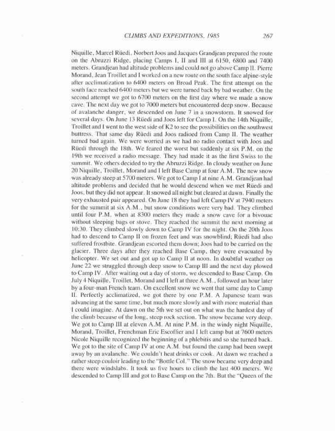
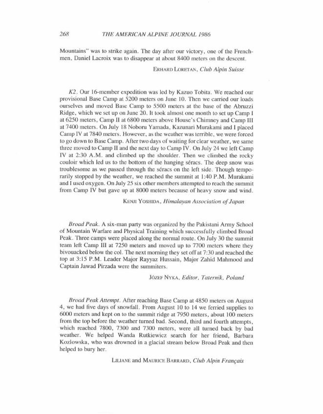
Gasherbrum I and II. Gasherbrum I (Hidden Peak) and Gasherbrum 11 have been climbed by teams of Quota 8000, an organization which has a five-year project to climb all the fourteen 8000-meter peaks. Our first expedition had as climbers Gianni Calcagno, Pierantonio Camozzi, Sergio Dalla Longa, Marino Giacometti, Giambatista Scanabessi, Tulio Vidoni, Pierangelo Zanga and me as leader. On June 6 Calcagno, Scanabessi and Vidoni completed a two-day ascent of Gasherbrum II by the 1975 French route up the southeast ridge. They de- scended in one day. On June 9 Camozzi and I completed a new route on the

CLIMBS AND EXPEDITIONS, 1985 271
extremely difficult northwest face of Gasherbrum I after eight bivouacs. On June 19 Calcagno and Vidoni got to the summit of Gasherbrum I after three days on a new route on the north-northwest face. We had only three or four “sunny” days in the 35 days we were climbing. Geographer Ciancarlo Corbellini studied the Balti population with particular attention to economy and agriculture. Gla- ciologist Claudio Smiraglia did research on glacial geomorphology and gla- ciology.
AGOSTINO DA POLENZA, Club Alpino Italian0
Gasherbrum I, II and K2. We established Base Camp at the foot of the Gasherbrums on June I. The weather was very unstable and there was much snow. We placed an Advance camp at 5900 meters between Gasherbrum I and II. On June 15 Benoit Chamoux and I arrived at the summit of Gasherbrum II, which we had climbed unroped from a bivouac at 7200 meters by the 1975 French route. This was both mixed and on ice with a maximum of 60”. We returned to our 5900-meter camp on June 20. Chamoux set off for the summit of Gasherbrum I (Hidden Peak) on the evening of the 21st and bivouacked at 7200 meters. I left just after midnight and caught up with Chamoux at 7500 meters. We got to the summit at three P.M. and I was back incamp at nine P.M., only 2 1 hours after leaving it. We had ascended through the Gasherbrum La and up the west ridge on snow and ice with a maximum of 70 “. We descended a little more to the left. On June 24 I went to the K2 Base Camp and there joined a different French expedition. I rested for ten days and then set out on July 4 with Daniel Lacroix, Jean-Francois Maniticat and Swiss Stefane Schaffter for the Abruzzi Ridge on K2. Four of the Swiss expedition started at the same time in fine weather. We slept at 6800 meters. On July 5 we climbed to 7400 meters and rested there until nine P.M. when three of the Swiss, Erhard Loretan, Pierre Morand and Jean Troillet, and I left in the light of the full moon. At 1:30 P.M. on July 6, I completed the first French ascent of K2 with the Swiss. The next day Lacroix and Schaffter also reached the summit. They descended with Schaffter ahead. He saw Lacroix for the last time at 8400 meters. The latter never was seen again and must have been swept away by an avalanche at 8200 meters in a dangerous crossing of a serac.
ERIC ESCOFFIER, Club Alpin Fraqais
Gasherbrum I, Northwest FaceSolo. G. Di Federico climbed a new route on the northwest face of Gasherbrum I to the right of the icefall. He set out from 5900 meters early on July 13 and climbed along a ridge crest to 6300 meters. The next day he continued to the top of the spur at 7200 meters finding mixed climbing of UIAA difficulty JV and V. From there to the summit he had fewer problems. His companions attempted the Dacher route but had to give up at 7500 meters because of frostbite of E. Di Marzio. The others were Enrico De Luca. G. Zuccarini and C. Ricciuti.
272 THE AMERICAN ALPINE JOURNAL 1986
Gasherbrum I (Hidden Peak) Attempt. We were Dr. Dave Bong, Gary Le Moine, Richard Soaper and Ethan Van Matre, lead team, and Jonell Geller, Bill and Dana Isherwood and I, support team. We reached the 17,400-foot Gash- erbrum Base Camp at the confluence of the Abruzzi and South Gasherbrum Glaciers on July 3 after eleven days with absolutely no porter problems, using the well known Baltoro approach. No porters carried beyond Base Camp. In the ensuing weeks we had established Camp I at the top of the first icefall by July 13 as the lead team worked higher on the route. Camp II, near the base of the west ridge of Gasherbrum I, was occupied on July 21 after unscheduled rest days due to bad weather. Camp III on the Gasherbrum La between Gasherbmms I and II was first reached on July 18 but not occupied until July 24. On July 27, after waiting out two days of bad weather in Camp III, the lead team made an alpine- style push for the Messner-Habeler high camp on the north ridge of Gasherbrum I, but after eight hours of battling thigh-deep snow over unstable, down-sloping slabby rock to 22,700 feet, they realized they were less then halfway to their goal. Insufficient food remained on the mountain to support a second attempt and so the route was cleaned and all members were back in Base by July 29. Looking back with 20120 hindsight, I see three errors: (1) all members should have come back to Base after stocking Camp III before the alpine-style summit push, (2) all available food should have been loaded into the camps rather than only enough for one attempt, and (3) one can never be too careful about party selection.
ROBERT A. WILSON
Gasherbrum II, Italian Women’s Altitude Record. Our expedition, for rea- sons of permissions, consisted of Gabriel Slovina Ubaldini, Valerio Bruschi, Enrico Mutti, my wife Goretta and me, but Goretta and I actually operated completely independently of the others. After arriving at Base Camp at 5100 meters on June 12, we reconnoitered to Gasherbrum La but were stopped there by bad weather. We were on the 1956 Austrian route. The weather cleared on July 5 and the next day we set out for Advance Base at 6000 meters. We continued from there alpine-style. On July 7 we bivouacked at 6500 meters, on the 8th at 6900 meters and on the 9th below the rocky final pyramid at 7400 meters. Strong winds kept us storm-bound all the next day and on July 11 we two reached the top at 4:30 P.M. My wife was not really a climber before and had worn crampons only on a couple of occasions. She had accompanied me to Base Camp on other expeditions, but now she is the first and only Italian woman to have climbed so high. The other members of our group attempted the same route. Gabriel Slovina Ubaldini reached the summit with porter Mohammed Ali an hour after us.
RENATO CASAROTTO, Club Alpino Italian0
CLIMBS AND EXPEDITIONS, 1985 273
Gasherbrum II. Ours was the first commercial French expedition to an 8000er. We had three guides: Michel Vincent, Albert0 Re and me. On July 11 Vincent, Re, Olivier Paulin, Theo Mayer, Pierre Gevaux, Andre Molinaire, Christian Fremont, all French except for Italian Re and American Mayer, and high-altitude porters Ghulam Hassan and Ibrahim reached the summit of Gash- erbrum II (8035 meters, 26,362 feet). Gevaux descended in five minutes by parachute to Camp I at 6000 meters. That same day Italians Renato Casarotto, his wife Goretta, Gabriel Slovina Ubaldini and high-altitude porter Mohammed Ali also reached the summit. She was the first Italian woman to climb an 8000er. Tragically shortly thereafter Jean-Pierre Bouygues died on the descent from Camp IV from cerebral edema. With us was also the team of Jean-Marc Boivin. He had reached the summit on July 8 in the company of Bernard Prudhomme, Laurent Chevallier, Michel Poencet, Francois Diaferia, Gerard Vionnet-Fuasse and Pakistani porter Little Karim, who carried a hang-glider. They had con- tinued on despite the death on June 24 of their Japanese photographer, Tam Nakano. He was jtimaring between Camps I and II. Because the fixed rope was buried in new snow, he released his Jtimars to try to climb the final ten meters to a terrace. The snow collapsed under his feet and he fell 400 meters to his death. On July 13 Boivin set out from Camp I with porter Ghulam Hassan and climbed to Camp IV at 7400 meters. After climbing solo to the summit on July 14, he descended to Camp I in the hang-glider. All these ascents were by the normal (Moravec) route.
CLAUDE JACCOUX, Club Alpin Francais
Gasherbrum II, Parachuting and Hung-Gliding. Among other exploits achieved by French climbers on Gasherbrum II, two impressive records were set. On July 11 Pierre Gevaux successfully descended by parachute from the summit. On July 14, Jean-Marc Boivin made the first descent of an 8000er by hang-glider. On July 8 he carried his 17-kilogram hang-glider to the summit but strong winds prevented the start. Six days later Boivin again reached the summit-in 16 hours from Base Camp! On the top he had to spend four hours to free the hang-glider from fresh snow and to start when there was no wind. The flight to Base Camp took 20 or 25 minutes. It was hazardous because of fatigue after the speedy climb, the work on the summit and the reduced carrying ca- pacity of the air, which at 8000 meters is only a quarter that of sea level. In September 1979 Boivin made a hang-glider descent from Camp IV at 7600 meters on K2. The previous record, however, was made on May 12, 1984 when Japanese Naotaka Tadano descended from 7800 meters in 19 minutes to 5 100 meters from below the main peak of Kangchenjunga.
J~ZEF NYKA, Editor, Taternik, Poland
Gasherbrum II, Ski Descent of South Face. After the other members of our expedition had to return to France, Pierre Mure-Ravaud and I reached the sum-
274 THE AMERICAN ALPINE JOURNAL 1986
mit of Gasherbrum II on July 3 1 by the normal route. Also on the summit that day were members of another French and a Swedish expedition. There was fog on the summit. All the others descended. I waited on the top for the clouds to lift in order to photograph. An hour later I put on my skis and began the descent. I caught up to the others at the 7700-meter col. There Michel Metzger of the other French group put on the boots and skis left a couple of weeks before by Boivin. In the fog, he misjudged the slope, took a fall but was able to stop. I had intended to continue skiing down the south face to Base Camp that same day, but since my climbing companion Mure-Ravaud appeared indisposed, we bivouacked at Camp IV at 7500 meters. The next morning Mure-Ravaud descended with the Swedes. Since Metzger had not originally planned to ski down, he had not observed the route through a serac barrier, as I had with binoculars from below. He waited for me. Once out on the broad slope, he skied down the left side and I on the right. Suddenly he hit a slick of ice. His skis fell off and he hurtled down the slope. Some 200 meters lower the slope lessened and he came to a stop. I skied to him and found him alive! From the foot of the face at 5900 meters, we regained Camp I at 5400 meters. The south face had never before been ascended or descended.
TIERRY RENARD, Club Alpin Franfais
Gasherbrum II. Four of our eight members reached the summit of Gash- erbrum II. On July 16 Francois Germain, who is Swiss but has lived for four years in Sweden, got to the top with the Japanese Tomaji Kato. Kato’s compan- ions, Takashi Takahashi and Masaki Matsumoto, got to the summit on July 28. On July 3 1 Tommy Sandberg, Per-Olof Bergstrom and I also reached the sum- mit. Seven Frenchmen were also on top that same day. We all climbed the normal route, with camps at 6000, 6500, 7000 and 7500 meters. One of our members got to just above Camp IV but had to descend because of an intense cough and fever. Another reached Camp II but returned to Base Camp because of snowfall. Back in Base Camp, he developed a deep venous thrombosis in his right leg and was evacuated by helicopter. One member developed pneumonia after arrival in Base Camp. He reached Camp I only once. Five days before he climbed to the summit, Gerrnain carried a female French climber down from Camp II to Camp I on his back. She was exhausted, could not walk and was hallucinating. The French doctor had almost given up hope for her life. The steepest part of the route was between Camps I and II.
PETER WENG, Svenska Fjiillklubben, Sweden
Gasherbrum II. On July 31 members of the French expedition led by Louis LePivain reached the summit of Gasherbrum II by the normal route. They were LePivain, Michel Metzger, RCmy PillSgre, Nicolas Campredon and Guy Flecher. On August 1 Metzger accompanied Tierry Renard in a ski descent of the south face, while the Swedes and the others helped ailing Mure-Ravaud, Renard’s companion, off the mountain.
CLIMBS AND EXPEDITIONS, I985 275
Gasherbrum III, Southwest Ridge Attempt. Our objective had been the north ridge of Gasherbrum III, which was reconnoitered by Cassin in 1958. In the event, we tackled instead the long, rocky southwest ridge, which rises from the top of the dangerous 800-meter icefall between Gasherbrum II and Gasherbrum IV. Our party, comprising Paul Nunn, Clive Rowland, Des Rubens and me, arrived at Gasherbrum Base Camp on July 11. After placing an intermediate camp halfway up the first icefall, we placed Camp II at 6000 meters at the base of the southeast rib of Gasherbrum II, which was being attempted by numerous parties. By the end of July, we had found a route through the second icefall, with an ice cave halfway up, and had established an ice cave in the remote upper cirque between Gasherbrum III and IV. A five-day period of very bad weather sent us down to Base Camp, and Rowland and our liaison officer departed soon afterwards. On August 11 we regained Camp II in very deep snow. Nunn then departed, leaving the two of us to make the final attempt. We remade the trail to the upper cirque and embarked on the ridge on August 14. The wind was very strong and the weather poor. The climbing was mixed II to III by Scottish or Alpine standards. We bivouacked at 7400 meters on a very exposed patch of snow. On the 15th we left all the bivouac gear behind and attempted to reach the summit. After four hours of unroped climbing, we had to start climbing in pitches and this slowed us considerably. We reached 7700 meters, just below a horizontal step that lies below the summit tower, but bad weather and lack of time compelled a retreat. Des Rubens contracted frostbite in our second biv- ouac, but we regained Base safely on August 19. The circus-like atmosphere of the Gasherbrum Base Camp, the rubbish left by other expeditions and the strains of a busy social life were not the sort of pressures we had been expecting. A major task was tidying up the huge amount of junk left by other expeditions.
GEOFFREY COHEN, Scottish Mountaineering Club
Gasherbrum VI. Maria Luisa Ercalani led this expedition about which we were able to obtain no details. On the approach march a low-altitude porter on May 9 fell off a bridge near Chapko and was drowned. She claims to have climbed Gasherbrum VI (7003 meters, 22,975 feet) from the Duke of the Ab- ruzzi Glacier. In Mountain 106 it states, “The likely route of ascent involves considerable objective dangers and steep ice and seems to have been achieved with no support whatsoever. Because of her age and sex, her activities were treated with incredulity by climbers in the vicinity and even more so by the Pakistanis.”
Masherbrum from the Northwest and Broad Peak. The Kansai Karakoram Expedition left Skardu and after traveling up the Baltoro Glacier, established Base Camp on the Yermanendu Glacier at 4600 meters. They placed Camp I at 5600 meters on the north ridge on June 6, but frequent collapses of the upper glacier forced them to traverse right to the northwest ridge. Camps II, III and IV were established at 6100, 6300 and 7200 meters on June 13, 29 and July I 1.
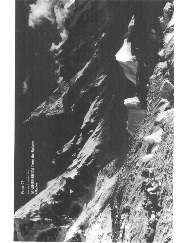
CLIMBS AND EXPEDITIONS, 1985 277
They fixed much rope. Above Camp IV, the northwest ridge was dangerous because of rotten rock and so they traversed further right and eventually climbed the northwest face to the co1 between the main and southwest peaks. The summit (7821 meters, 25,660 feet) was reached by all members on July 23. They were Shin Kashu, leader, Tsuneo Shigehiro, Jyoshi Wada, Riichi Nishzutsumi, Et- suo Terauchi, Hiraoki Ito, Yoichi Yabukawa, Munehiko Yamamoto, Tetsuya Toyama and Masashi Tatsuta. As they climbed toward the summit ridge, the team found the body of one of the Polish climbers, Marek Malatyriski or P. Nowacki, who on September 17, 1981 tragically died after making the first ascent of Masherbrum Southwest. This was the third ascent of Masherbrum, which had been climbed in 1960 by Americans and in 1983 by Japanese.
SADAO TAMBE, Himalayan Association of Japan
Masherbrum, Northwest Face. Our expedition consisted of Michael Larcher, Andreas Orgler, Hans Bamthaler, Christoph Rimml, Thomas Burt- scher and me as leader. After leaving Skardu on June 17 with 63 porters, we got to Base Camp on June 25 at 4300 meters on the Mandu Glacier via Askole and the Baltoro Glacier. The route to Camp I was very technical (rock up to 5.9 and ice up to 85”). We established Camp 1 at 5500 meters on June 30. The route to Camp III was on a ridge and a slope of 55” to 60”. We placed Camps II and III at 5950 and 6300 meters on July 5 and 10. A summit attempt reached 7000 meters on July 12. Burtscher and Rimml left the expedition on July 17 because of the enormous danger of falling rock and ice. On July 21 we other four started another summit try. Bamthaler had to give up at 7000 meters on July 23, but Orgler, Larcher and I bivouacked at 7200 meters. From there to the summit (7821 meters, 25,660 feet) the route was mostly rock climbing (5.7 to 5.8) with some ice couloirs. We reached the top on July 24, 22 hours after the Japanese. We fixed a total of 600 meters of rope.
ROBERT RENZLER, dsterreichischer Alpenverein
Masherbrum Attempt and Geological Expedition. Our expedition spent three months in the Baltoro Karakoram with the dual objectives: to conduct a geological survey of K2 and the Gasherbrum group in the northeast to the Shigar valley in the southwest and to climb Masherbrum via a new route on the northern (Baltoro) side. We six geologists: British Tony Rex, Brian Windley and I, Canadians Rein Tirrul, Paul Hoffman and Marc St. Onge; two climbers British Dave Mould and American Dana Coffield; a medical doctor British Owen Boyd; and Pakistani liaison officer Attaul Haque. We left Dassu on May 13 with 70 porters. Conditions on the upper Baltoro remained very wintery with deep snow and slush covering crevasses. Windley fell into a glacial river near Goro and developed hypothermia and altitude sickness; he was evacuated from Concordia by helicopter. Hoffman and St. Onge left for Canada on May 27, leaving only Tirrul, Rex and me to do the geology. Rex and I spent one month in the Godwin-
THE AMERICAN ALPINE JOURNAL 1986
Austen Glacier area and climbed to 6500 meters on the Abruzzi Ridge of K2. Lack of permission, bad weather and Rex’s stomach problems prevented our going higher. Tirrul studied the geology of the lower Baltoro, Braldu and Pan- mah valleys. He also explored the little known Chongking valley east of Mango Gusor, the Mango Glacier region east of Bakhor Das, ascended the Skoro La from Askole and the Talle La from Shigar and the Baumaharel valley. The expedition reassembled at Urdokas on June 16. Dr. Boyd developed gallstone pains and left for England. Rex, Coffield, Mould, Attaul Haque and I set up Base Camp on the Yermanandu Glacier on June 18. During late June we had two weeks of continuously bad weather with white-outs and heavy snowfall but no winds. We carried loads to the base of the face west of the Masherbrum La, where we made our third dump. We planned to climb the east ridge of Mash- erbrum, considering most lines on the north face too dangerous with avalanches continuously pouring down. Our route looked daunting, being over four miles long with several subsidiary bumps en route crowned at the top by a lOOO-foot wall of blank-looking granite. Temperatures were not low enough to freeze the fresh snow. Even climbing from midnight to dawn, we sank in knee-deep. On steeper ground, we often waded waist-deep, sometimes chest-deep! Our route was threatened by a huge line of seracs and we dared not traverse beneath them under such conditions. We abandoned the climb on June 30. Immediately after we pulled out from Masherbrum, the Baltoro experienced a continuous 15-day spell of immaculate weather. Rex and I spent two more weeks studying the geology of the upper Baltoro, South Gasherbrum and Vigne glacier systems. We also explored the Dunge Glacier and Trango Tower group with Dana Coffield and “bouldered” around the base of the Grand Cathedral. The geologi- cal exploration was a great success. We had trekked up every major glacier on the upper Baltoro and Godwin-Austen basin, studied the base of K2, Broad Peak and the Gasherbrums, as well as exploring the Younghusband, Dunge, Vigne, Yermanandu and Liliwa Glaciers. We collected 200 kgs of rock samples for geochemistry, isotope chemistry, age dating and microprobe work. We were able to compile a geological map of the Shigar-Braldu-Panmah-Baltoro and Godwin-Austen valley systems.
MICHAEL SEARLE, Department of Geology, University of Leicester, England
Mustagh Tower Correction. The British party that climbed the Mustagh Tower, as reported on page 3 18 of A.A.J., 1985, made the second ascent of the lower west summit. The second ascent of the higher east summit was made by Guido Magnone’s party in 1956 one week after the British first ascent.
TREVOR BRAHAM, Alpine Club
Trango Attempts. Two Japanese expeditions both failed to climb the easternmost of the Trango Towers (5753 meters, 18,875 feet) by its southwest buttress. The first party, led by Yoshimitsu Takatori, in June got to about 1000

CLIMBS AND EXPEDITIONS, I985 279
feet from the summit. Other climbers of the group climbed Karphogang (5931 meters, 19,460 feet). In September, the two-man party, Hiroshi Aota and To- shiyuki Kikuchu, had hoped to try the same route, but they were prevented by new snow from climbing high.
Latok II Attempt. A four-man Japanese expedition led by Tomoyasa Yam- azaki failed at 6200 meters to climb Latok II.
Ganchen Group. Chris Forrest and I reached the Sosbun Glacier on July 30 after a three-day walk from Dasso with five porters. We had originally hoped to attempt the rocky spires that make up the peaks of the west Biafo wall. How- ever, on this side of the range the rock is obviously and universally appalling! We turned our attention further west to the Ganchen group. Base Camp was on the lateral moraine of the Hoh Lungma Glacier at 4250 meters. We climbed Bakree Peak (c. 5050 meters, 16,568 feet) via the northwest face and northeast ridge on August 2. From an advance base near the head of the Chongahanmung Glacier we ascended Zam I and II (5200 and 5150 meters, 17,061 and 16,897 feet) via the north face on August 10 and Hoh Lungma Peak (c. 5600 meters, 18,373 feet) via the east-northeast face on August I I. All four were previously unclimbed. The main objective, the heavily corniced east ridge of Hikmul(6410 meters, 21,031 feet) was abandoned at two-thirds height after three days of climbing due to dangerous snow conditions even during the night. On August 16 an attempt on Ganchen South (c. 5750 meters, 18,865 feet) was also thwarted. The weather was poor with rain on 80% of the days. With mild temperatures, the snow conditions were the worst we had ever encountered. Alarmingly, we did find large “yeti”-like footprints in moraine mud which bore a remarkable simi- larity to previous photographs. We presume they belonged to a large species of bear. We began our walk back to Dasso on August 2 1.
LINDSAY GRIFFIN, Alpine Climbing Group
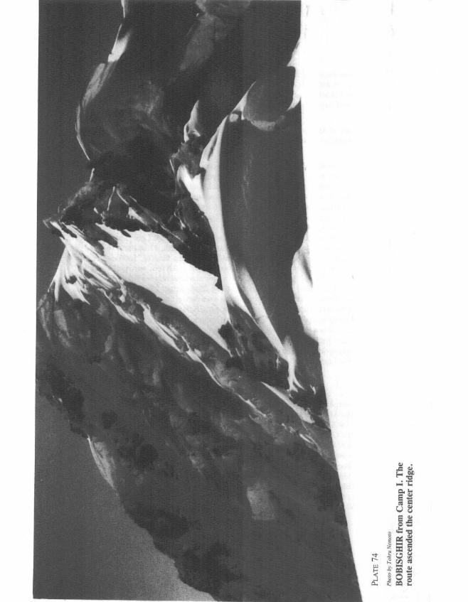
Bobisghir. Our expedition was composed of Yukitoshi Tanikawa, leader, Shinichiro Kasai, Takeshi Oshida, Dr. Shigeki Nakajima and me. After leaving Dasso on May 28, we established Base Camp at 4850 meters on the Nobande Sobande Glacier on June 5. Since we were too far from the foot of our ridge, we deposited material at 5200 meters. Camp I was established on June 20 at 5750 meters on the junction peak. Between Camps 1 and II there are two small fore- summits. We made a deposit camp on the first one at 5950 meters. We spent a lot of time on this portion of the climb because of much snowfall. On July 2 we established Camp II at 6200 meters beyond the second foresummit. On July 7 Kasai, Oshida and I completed the first ascent of Bobisghir (6416 meters, 21,050 feet).
TOHRU NEMOTO, Nihon University, Japan

COLOR PLATE 5 Phoro by H. Adamv Caner
MASHERBRUM, Karakoram.
282 THE AMERICAN ALPINE JOURNAL 1986
Lukpe La Brakk Tragedy. A six-person group of the South Wales Mountain- eering Club came in July to Snow Lake of the Biafo-Hispar Glacier region, hoping to climb there. Dave Parsons had altitude problems and left with his wife. After Bob Williams was injured in a crevasse fall, he was evacuated by Don Hillman. Dr. Michael Harber and Dr. Michael Morris stayed on, hoping to climb Lukpe La Brakk. They have been missing ever since. Despite an exten- sive search, no trace of them has been found.
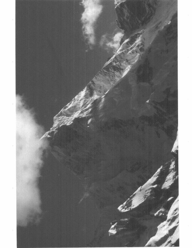
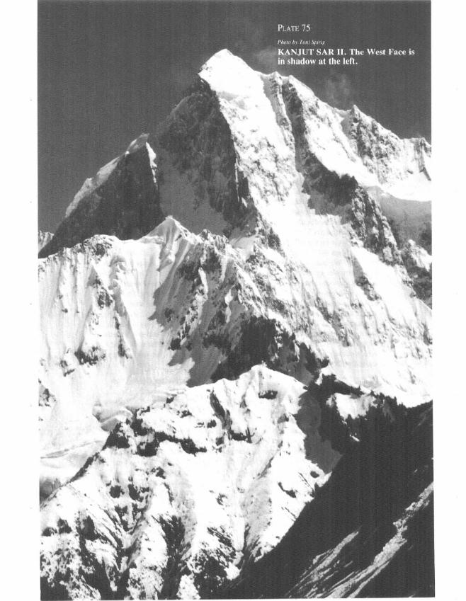
Kanjut Sar II. Our expedition comprised Daria Vezzoli, Ueli Stahel, Richi Ott, Hans Peter Achtnich and me as leader. On the approach march along the Hispar Glacier from Nagar with 29 porters, we had lots of problems. Endless discussions over wages, food rations and daily stages kept us busy. After 11 days we established Base Camp on June 19 on the Khani Bass Glacier at 4650 meters. Our first attempt on Kanjut Sar II ended high in bad weather on a route with technical difficulties. Short of time, we attempted the unascended south face of Kanjut Sar I. From an Advance Base at 5000 meters we started on July 5 alpine style up the steep face. Frontpointing for the first six pitches in hard ice of more than 60”, we gained 250 meters. The angle lessened, allowing good progress. We had just set up Camp I at 5700 meters when we heard the sound of tons of wet snow sliding. We jumped aside to a safer spot. The avalanche swept away our camp, leaving us barefoot in the snow. Fortunately we could dig out enough gear to descend, but it was difficult without outer boots. Stahel, Ott and I decided to try Kanjut Sar II alpine-style. We climbed the west glacier, which had some pitches up to 50”, to the saddle between the summit and P 6500. We established Camps I and II at 5800 and 6400 meters on July 8 and 9. It stormed on the second night, but July 10 was perfect. After a traverse around a rocky ridge, we climbed a gully of steep black ice. Between the rocks and the seracs of the summit shelf glacier, the ice was 70”. After this, we worked up soft snow to the summit (6831 meters, 22,411 feet).
TONI SPIRIG, Schweizer Alpen Club
Diran Ascent, Nanga Parbat Attempt and Other Peaks near the Karakoram Highway. We left Britain on June 18, hoping to climb rock pinnacles in Hunza, the Rakaposhi north face and Nanga Parbat from the south. We failed on all of these but did climb Diran and several minor summits. Basically heat and disease severely weakened us, a situation exacerbated by being constantly on the move with four different Base Camps and also, to a lesser extent, by porter troubles. After travelling up the Karakoram Highway, we reached Karimabad on June 30, where we split into two groups. My son Michael Scott, Alastair Reid and Ice- lander Snaevar Guomundson went up into the Passu Glacier area. Mark Miller, Sean Smith, American Stephen Sustad, Australian Greg Child, Pakistani Nazir Sabir and I went up to camp three hours above Karimabad on a pasture at 8000 feet by the Ultar Glacier. After waiting for fresh snow to clear, all but Nazir in two days climbed a steep dangerous couloir to a co1 beneath Bubli-MO-Tin
CLIMBS AND EXPEDITIONS. 1985 283
(6000 meters), a 3000-foot rock pinnacle southwest of Bojohaghur Asir. Gen- eral lethargy prevailed as everyone had diarrhea and Child was passing blood. Sustad and I climbed a minor peak to the south of our col. We retreated, dodging stonefall, down the couloir. Nazir, his Japanese fiancee Fumi and our cook Mohammed narrowly escaped a huge avalanche on a goat path above Base Camp. Many goats were not so lucky. Temperatures were at midday 40” C. and remained high for weeks. In the Hunza Valley it reached 47” C. The Passu team returned also suffering from the heat and infection, We moved our gear to Minapin and set off for Diran. After five hours of walking spread over two days, we camped beneath the northeast ridge of Rakaposhi in the ablation valley by the Minapin Glacier at 8000 feet. The 51 Nagar porters demanded 9? 750 for this carry, some of which we agreed to pay then and we said we’d discuss the rest with the local police chief on our return. An ugly incident ensued with their threatening us with strikes. Knowing that some German trekkers had previously been murdered by Nagars on a nearby glacier, we paid up. Later, Nazir, who was fighting a long court case in Islamabad, went down and en route reported the incident. Subsequently seven Nagars were put in jail. Periodically we were visited by the police and local leaders, who informed us the prisoners would be flogged and possibly jailed for six months. Terry Mooney arrived from Ireland, but an old knee injury put him out of action. He went down to plead for the Nagars on our behalf and succeeded in securing their release. Child, Sustad and Guomundson also departed as their condition became worse. At Base Camp Miller made a fine solo ascent of P 5677, which lies due north of the north co1 of Diran from the southeast. Icelander Helgi Benediktsson, who had fallen ill on the way in, was now in better health, as were Mark Miller, Michael Scott, Alastair Reid and I. We moved up the Minapin Glacier to camp at 4000 meters. From there we climbed the original route on Diran (7266 meters, 23,840 feet) in a two-day push to the summit. The same route was climbed the day before by Edi Koblmuller’s Austrian expedition. We descended to bivouac some 2000 feet down the west-northwest ridge. Benediktsson had been unable to reach the summit with us and so he went up the following day with an Austrian. Three days later Nazir returned from court to climb with Sean Smith to the summit plateau, but bad weather prevented their reaching the summit. Four of the Aus- trians had climbed the unclimbed east summit of Rakoposhi by the north- northeast ridge; we had planned to go to the main summit this way. Koblmiiller staggered into camp late at night telling us that at the end of the difficulties on the descent one of his team had slipped and was in Advance Base with serious head injuries. He asked us to go up with pain killers and do what we could in the way of a rescue whilst the Austrians’ liaison officer want for a helicopter. Early next morning we arrived to find the man had died. We returned to Base Camp just as the helicopter arrived. It was a faultless operation on the part of the liaison officer and the Pakistani Army. We called in at the local courthouse to discuss porter problems. The magistrate agreed, on hearing evidence from the police chief, that the journey to our Base Camp by the Minapin Glacier should be counted as one day from Minapin, less than an eight-hour carry. If this principle
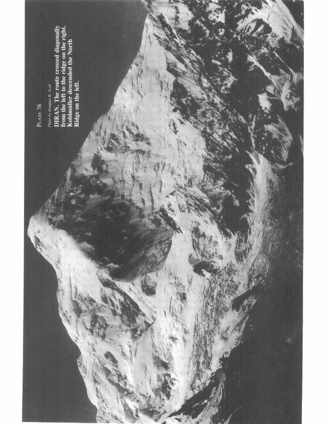
CLIMBS AND EXPEDITIONS, I985 285
were more rigourously applied in this part of the Karakoram, it would be more in line with the cost of porters in Baltistan. We arrived at the Rupal Base Camp for Nanga Parbat on August 12 after a harrowing tractor-.jeep ride to the road- head, from where we continued for two days on foot and horseback. On August 15 Alastair Reid, Michael Scott, David Marshall, Nazir, my 12-year-old daugh- ter Martha and I went to the west side of Rupal Peak. After three bivouacs and some Grade 3 ice climbing we were established 800 feet from the summit. All but Martha, who had bad stomach pains, and I went to the summit via this new route. Then although none of us was in really good shape, Michael Scott, Reid, Nazir and I decided to go for the southwest ridge of Nanga Parbat. We climbed appalling loose rock to camp at 21,000 feet. The next day we reached 24,000 feet in a storm and hurricane-force winds. We backed down 500 feet and biv- ouacked. Reid was ill, possibly with a mild oedema, so we descended the next day to Base Camp. A few days later our much depleted party hired horses and galloped out to the roadhead.
DOUGLAS SCOTT, Alpine Climbing Group
Diran and Rakuposhi Ascents and Tragedy. There were three groups in this region in July and August, two smaller private parties and ours of the Upper Austria Alpine School. I was the leader of the Diran Group and Edi Koblmiiller was the Rakaposhi leader. Our weather was excellent. From our 3650-meter Diran Base Camp we placed Camps I, II and III at 4900, 5500 and 6300 meters on the normal route. Between July 23 and 30, the summit (7266 meters, 23,840 feet) was reached by Fred Pressl, Heinz Thallinger, Roland Schulz, Edi Ko- blmiiller, Ingo Granderath, Hungarian Istvan Katouna, Gerald Fellner, Nani Klappert, Herbert Spousta, Christ1 Stager and me. Press1 and Koblmtiller made the first descent of the north ridge on July 24. On July 27 we began to climb Rakaposhi East by the north buttress. After reconnaissance, we set out on July 30 on an alpine-style ascent from a 4500-meter Advance Base. From Bivouac I at 5500 meters to Bivouac II at 6000 meters, the route was up a 65” steep ice slope and a very exposed, sharp ridge. On August 1 Koblmtiller, Pressl, Fellner and I reached the summit (7010 meters, 23,000 feet). We descended that day and the next in bad weather. At 4700 meters Fellner slipped and fell 100 meters down an ice slope. Despite medical attention, he died in the night.
GERHARD HABERL, Obertisterrichische Alpinschule, Austrin
Dir-an Artempt. Our expedition consisted of Jaume Anglada, Miquel Serrat, Joan Sola, Xevi Robiro R., Xevi Roviro A. Josep Rovira, Joan Colet and me as leader. We had hoped to complete a new route up the north ridge, previously attempted by Spaniards in 1979, who got to the co1 at 5020 meters, and Japanese in 198 1, who got to 5650 meters. On May 30 we contracted for 4 1 porters in the town of Minapin. In three days we got to Base Camp at 3615 meters on June 3. We placed Camp 1 at 4375 meters on July 5 in a spot protected from avalanches on the east glacier leading to the col. On June 10 the preparation of the route to
286 THE AMERICAN ALPINE JOURNAL 1986
the co1 was complete with some fixed ropes. The 45” to 50” slope to the co1 got progressively steeper and near the top there were places it was 75” to 80”. The ridge from the co1 to 5300 meters was steep but uniform with some rotten rock and some cornices. From 5300 to 6100 meters the ridge was much rougher with many huge overhanging seracs. The first camp site was at 5400 meters, placed there on June 2 1. It was a long carry from Camp I and we had some bad weather. Above Camp II we found Japanese material cached at their high point. We bypassed a great serac on the left, found 100 meters of easier snow and again seracs and steep snow to 6000 meters, where on June 29 we placed Camp III. That night was disturbed in all camps. In Camp I a bear broke into supplies and ate up 30 man-days of food. In Camp III the climbers worried about the “steps,” a series of snow and ice towers, covered with powder snow. After five hours, we got only to the top of the first step. The towers were very unstable, continuing for over 300 meters. We lacked rope to fix the route. That same day we evacu- ated Camps I, II and III.
ANGEL SERRA, Unid Excursionista de Vie, Spain
Mulangutti Sm. On August 12 a Japanese expedition made the first ascent of Malangutti Sar (c. 7025 meters, 23,048 feet). The leader Tadao Sugimoto, Kengo Nakahara, Yasushi Muranaka and Ang Nima Sherpa got to the summit.
Lupgha Group, Baturu Glacier. On August 19 Steve Goodman, Del and Steve Davis and I flew to Gilgit. The next day we hired a jeep to drive up the Karakoram Highway to Passu, about 50 kilometers from the Chinese border. We started with six porters and ascended the north side of the Batura Glacier for three days to Guchisham, a shepherd village. There we left the main glacier and ascended northeast towards the Lupgha group. The porters left us at a small lake at 4400 meters, promising to return in a week. Our old Survey of India map indicated that there were a number of peaks nearby between 5500 and 6000 meters. The porters stated that no foreigners had approached the area before. We ferried loads to the highest practical campsite at 4800 meters. A snowstorm forced us to one rest day. On August 28 we moved to the high camp, leaving Goodman at the lake camp with stomach problems. The next morning we as- cended rotten gullies and crossed a crevassed glacier to find that our expected plateau was actually a narrow ridge. Proceeding south just under its crest, we arrived at a pointed snow summit registering 5500 meters on my altimeter. A slightly higher point on the ridge, marked 5800 meters on the map was too far away and complicated to reach. We descended to the lower camp, where Good- man was waiting. The next day we went down to the main Batura Glacier. We ascended the main glacier for two days and climbed a pointed 4800-meter peak which provided a panorama of the region. It revealed there were no easy 6000-meter peaks waiting to be climbed. We packed down to Passu in two days with four porters, arriving on September 3.
GENE F. WHITE
CLIMBS AND EXPEDITIONS, 1985 287
Serei Porkush, 1984. More details are available on the first ascent of 6872-meter (22,546-foot) Serei Porkush. The peak lies south of Kampir Dior above the lower part of the Batura Glacier. The British climbers took eight days to ascend the glacier and place Base Camp at 3650 meters on July 21, 1984. Advance Base was established on July 29 at 4875 meters after an eight-mile ascent through icefalls. On July 30 they placed a camp at 5250 meters at the foot of the west ridge. From there Steve Pymm and Martin Burregar climbed alpine- style in five days to the summit, which they reached on August 4, 1984.
Passu I and II Ascents and Nanga Parbat Attempt. Our expedition consisted of Yoshitoyo Oishi, Katsuto Soejima, Naoya Yamasaki, Koji Yamauchi, Dr. Tetsuro Nishida and me as leader. We climbed the Passu peaks from the east. Our route went up the Passu Glacier, on which were two icefalls and many crevasses, which made us take a long time. We established Base Camp, Camps I, II and III at 4180, 5200, 6150 and 6840 meters on June 13, 20, 30 and July I I. There was no altitude gain from Camp III to the summit of Passu II (6842 meters, 22,447 feet) but Oishi and Yamauchi had to traverse 2% kilometers to reach the top on July 12. It was the first ascent of this peak, which lies east of Passu I. On July 14 Yamauchi and Nishida made the second ascent of Passu I (7284 meters, 23,900 feet). We had climbed the Passu peaks to acclimatize for our attempt on the southwest ridge of Nanga Parbat, the Schell route. We got to Base Camp on July 25 and made three high camps. We got to 7200 meters on August 14, but we were exhausted and lacked time. Yet our adaption to high altitude was a great success.
ISAO SHINKAI, Fukuoka Tokokai, Japan
Nanga Parbat Attempt. Our expedition was composed of Tony Lewis, leader, Scott Thorburn, Ron Matous, Dr. Mike Young, Rob Gustke and me. From Gilgit we hired jeeps on May 11 for the bone-jarring 12-hour ride to Tsharing in the Rupal valley. Our approach to Base Camp, located at 11,800 feet beyond Tap Alp, took one long day on May 12 with porters and donkeys. After scouting the Canadian route (Shagiri Icefall) and the Schell route to Camp I at 17,000 feet, we decided the latter was safer and more direct, if used between midnight and ten A.M. Between May 16 and 24 we each made five grueling nighttime carries. On May 23 we occupied Camp I. After fixing the difficult ground between 19,000 feet and Camp II at 20,000 feet with 400 feet of rope and ferrying loads, on June 3 we all moved to Camp II, which was perched on an icy knife-edge. June 4 and 5 were the only nice days we had between May 23 and June 27. Young headed down to Base Camp with flu symptoms and eventually left for the States. Finally on June 12 Lewis, Matous, Gustke and I plowed through deep snow from eight A.M. to seven P.M. to Camp III at 23,000 feet. Thorburn had to descend to Base Camp with a persistent G.I. problem. Our plan was to go alpine-style to Camp IV at 24,500 feet and then to push for the summit. Unfortunately, during the night of the 14th Lewis became altitude sick.
288 THE AMERICAN ALPINE JOURNAL 1986
Therefore, early on the 15th Gustke and I headed down with him. I left them at 21,400 feet and returned to Camp III. Matous and I hoped to climb upward the next morning but because of bad weather we headed down to Base Camp. On June 22 Gustke, Thorbum and I were back in Camp II for one last attempt. We knew we were in trouble when we found our cached gear under five feet of new snow. On June 24 Gustke and I gained only 1000 feet in hip-deep snow and reluctantly decided that further progress was impossible. It snowed 45 out of the 50 days we were in the Rupal valley.
MARKUDALL
Nanga Parbat. Twelve parties, including four from Japan, were given per- mission for Nanga Parbat in 1985. Fourteen of our expedition set up Base Camp at 4100 meters on May 21, hoping to climb the 1962 German route on the Diamir Face. We established Camps I, II and III at 5000,600O and 6600 meters on May 26, June I ‘and 3, cooperating with the international party that had got to Base Camp three days ahead of us. On June I5 the weather worsened and we de- scended from near the site of Camp IV until June 27. We placed Camp IV and V at 7200 and 7600 meters on July 2 and 5. Mamoru Kikuchi and Hiroshi Hanada got to Camp V on July 7 and left for the summit the next morning at 2:30. They stood on the peak at l2:35 P.M. We found a corpse of an American we assume to be that of Bob Broughton, who died in 1977, below Camp II. We buried him with his things, heaping up a cairn beside the Diama Glacier. We mourned for him. The other members of our group were Y. Ishibashi, T. Mur- aoka, S. Watari, S. Hara, M. Shima, H. Shinohara, T. Hayakawa, T. Mita, M. Tanaka, T. Takasu and J. Nakamura.
MITWO UEMATSU, Fukuoka University Alpine Club
Nanga Parbat, Diamir Face. Having left Rawalpindi on May 22, my wife Laurence de la Ferribre and I drove up the gorges of the Indus on the Karakoram Highway. We shared permission for Nanga Parbat with the Polish women led by Wanda Rutkiewicz. We started walking at Bunar Bridge and placed Base Camp at 4200 meters four days later on May 28. At Base Camp we found Stefan Werner’s Swiss and Mitsuo Uematsu’s Japanese expeditions. They too were on the 1962 German route, which is the safest on the Diamir Face. We placed Camps I, II and III at 5000,620O and 6900 meters on May 3 1, June 2 and 7. A few days later Austrians with Peter Habeler and Michael Dacher arrived. The camp seemed like an international climbing meet. The following three weeks saw several attempts but they were frustrated by bad weather, snow, wind and clouds. The Swiss gave up. Good weather returned at the end of June. We quickly got to Camp III but were held up there for three days. On July 4 we set up Camp IV despite much new snow. Our summit attempt on July 5 was stopped by deep snow. On July 6 and 7 violent winds pinned us to Camp IV. On July 8 we two reached the summit at l2:30 P.M. with the Japanese, Hiroshi Hanada and Mamaru Kikuchi. This was my wife’s second 8000er, as she had climbed
CLIMBS AND EXPEDITIONS, 198.5 289
Yalung Kang in 1984. She has climbed higher without supplementary oxygen than any other woman. She was the second woman to reach the summit of Nanga Parbat. We climb as a couple, which is our concept of what mountaineering and life should be, a human adventure in which the performance is not the only motivation.
BERNARD MULLER, Groupe de Haute Montagne
Nanga Parbat, First Ladies-Only Ascent. The first all-woman expedition to Nanga Parbat successfully climbed the mountain. The party consisted of Po- land’s top women climbers: Dobroslawa Wolf, Anna Czerwifiska, Krystyna Palmowska and Wanda Rutkiewicz. The doctor was Danielle Sierre of Switzer- land. Base Camp was established on the Diamir Glacier on May 29 at 4200 meters. The ascent was made by the 4000-meter-high Diamir face, the German route of 1962. Four camps were set up: Camps 1, II, III, and IV at 5000. 6100, 6850 and 7400 meters (the last in the Bazhin Basin) on June I, 4, I2 and July 5. The weather was unsettled and big snowfalls halted progress. The steep rock section below Camp II was difficult and provided exciting climbing, even though it was protected by old ropes and ladders. All camps were equipped unaided; the women carried loads of 20 to 25 kilos. There was much activity on the Diamir face; Japanese, German, Swiss and French parties were also present, On some days Camp I had ten tents! On July 8 the first summit ascents were made: Japanese Hiroshi Hanada and Mamoru Kikuchi and the French couple Bernard Muller and Laurence de la Ferriere. On July 9 or IO a big avalanche swept Camp IV. On July II Dobroslawa Wolf, German Michael Dacher and Austrian Habeler bivouacked there and the next day attacked the summit. Habe- ler and Dacher stood on top, but Wolf started two hours later and could only reach P 8075 on the summit ridge. The weather deteriorated and she descended enveloped by dark clouds and snowfall. The three other Polish women rebuilt Camp IV and on July 13 made a summit attempt, but they were turned back by deep snow and poor weather. On July I5 Czerwinska, Palmowska and Rut- kiewicz started at six A.M. The weather was bright but the fresh snow was very deep. Progress was slow, Unroped they reached the summit separately between 3:30 and 4:30 P.M. They descended to Camp IV. During the night the weather deteriorated once again. The descent in heavy snowfall, dark mist and knee- deep snow with heavy loads was the most difficult and most venturesome part of the expedition. The first woman to climb Nanga Parbat was Liliane Barrard and the second Laurence de la Ferriere, both climbing roped to their husbands. The Polish women had no male support or high-altitude porters. Three 8000ers have been climbed thus, all by Polish women: Gasherbrum II in 1975, Broad Peak in 1983 and now Nanga Parbat. For Wanda Rutkiewicz (Everest 1978) and Krystyna Palmowska (Broad Peak 1983) this was the second 8000er.
J~ZEF NYKA, Editor, Taternik. Poland
290 THE AMERICAN ALPINE JOURNAL I986
Nanga Parbat, Rupal Buttress Ascent and Tragedy. The Rupal Buttress of Nanga Parbat was very nearly climbed by Swiss Ueli Biihler on the 1982 Her- rligkoffer expedition. He reached the 8042-meter south summit, the top of the buttress, but could not go on to the top. A principally Polish expedition led by Pawel Mularz completed the route in 1985 on this southeast buttress. They had very bad weather and found the route dangerous. One of them, A. Samolewicz, fell 600 meters but miraculously was merely stunned. Piotr Kalmus was less fortunate. While returning to Camp I from Camp II he was struck by an ava- lanche and killed. On July 13 Poles Jerzy Kukuczka and Zygmunt Andrzej Heim-ich, Mexican Carlos Carsolio and American Slavomir Lobodzinski reached the summit from Camp V. This was the ninth 8000er for Kukuczka.
Nanga Parbat Attempt by the First-Ascent Route. Eight Japanese led by Kazuyuki Shimazu set up five camps on the northeast ridge of Nanga Parbat. On July IO Hideo Yokohama, Yutaka Mukai, Koji Hasegawa and Akira Echigoya left Camp V at 6900 meters for the summit but they had to turn back at 7550 meters. On the descent on July I I they climbed Rakiot Peak (7070 meters, 23,196 feet). For more details, see Iwa To Yuki, No1 13.
Nanga Parbat, Diamir Face. Michael Dacher and Peter Habeler reached the summit of Nanga Parbat via the Diamir Face on July 12. Their first attempt failed in bad weather about 650 feet from the top on July 6 in very severe weather. This was the eighth 8000er for Dacher and the third for Habeler.
Nanga Parbat, Rupal Face Attempt. With 36 porters, our six-man expedi- tion reached the Rupal Base Camp on August 3 I. On September I, one group with five porters established Camp I at 5100 meters. At that time the conditions were excellent and the section between Camps I and II was almost without snow. On the 3rd, two members climbed to the site of Camp II at 6100 meters. That very day the bad weather started and it lasted without interruption till the end of the expedition. Bad weather and snowfall made the part between Camps I and II dangerous and difficult. There was a lot of black ice and verglas on the rocks. Despite snowfall, we fixed ropes on that part and established Camp II. On September 23 one of our members was struck by a big rock on the head and suffered a concussion. On October 2 we tried a last unsuccessful push. On October 5 we left Base Camp.
JANEZ SKOK, Planinska zveza Slovenije, Yugoslavia
Nanga Parbat Attempts. Although many of the dozen expeditions that went to Nanga Parbat this year were successful, there were those which did not reach the summit. These include Swiss led by Stefan WGmer and Japanese led by Takashi Ozaki, both on the Diamir Face, Spaniards led by Albert0 Garcia Astudillo on the Rupal Face and Japanese led by K. Dobashi on the northeast ridge.

292 THE AMERICAN ALPINE JOURNAL I986
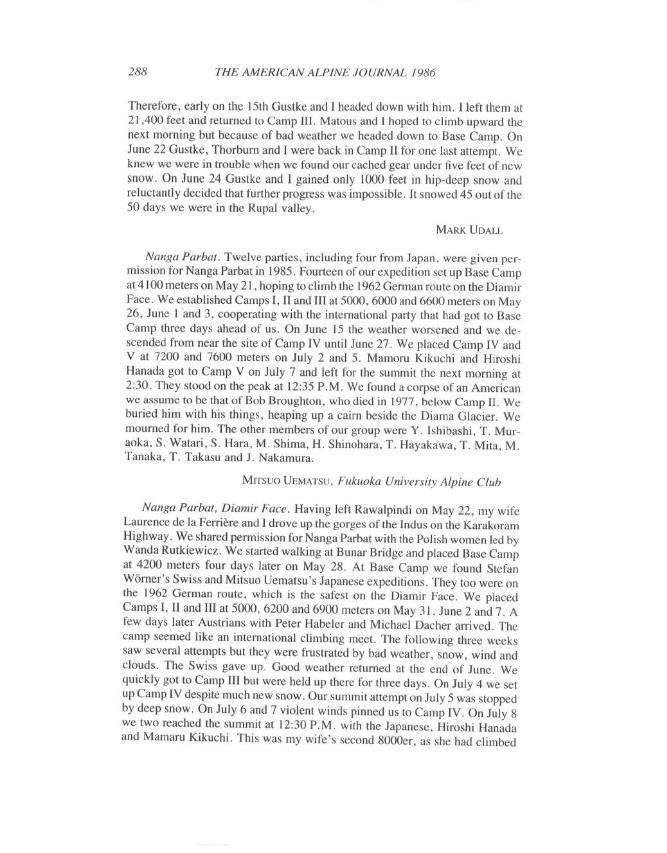
Ghul Lasht Zom South and Tirich North. Our expedition consisted of Ger Friele, Edmond Gfner, Egbert Veen, our liaison officer Shahid Mahmood and me. On July IO we jeeped to Zungrangram. With 33 porters we walked in three hours to Shagrom, where we had to change porters. (Next year the jeep road will reach Shagrom.) We stayed I i/z days negotiating with new porters. Finally we agreed to pay 450 rupees for the 1 %-day walk to Base Camp, which we reached at 4750 meters on July 14. On July I7 we bivouacked at 5 100 meters at the foot of the Aspe-e-Safed east face. The day after, we climbed the central couloir in six hours to the ridge at 6350 meters and descended to Base Camp. On July 2 1 we reconnoitered Tirich Mir IV’s northwest face and slept at the foot of the face. We decided first to climb the northeast face of Ghul Lasht Zom South. On July 22 we descended from our bivouac to climb the face. By the end of the afternoon we had reached a crevasse at 6000 meters where we bivouacked. On the lower part of the face we had some interesting ice climbing up to 65’; the middle section was less steep but the snow was in terrible condition; higher it became better. At ten A.M. the next day we reached the summit (6450 meters, 21,162 feet) and descended the north ridge. Ours was probably a new route. On July 27 we bivouacked below the northwest face of Tirich North. The next day we climbed the lower 1000 meters of the nearly 2000-meter face. The first part went right from the big serac; the bare ice was terribly hard and there was some rockfall. We climbed the first rock band up a kind of icicle to get to less difficult mixed terrain. The second and bigger rock band was climbed by a leftward- tending, steep, go-meter ice couloir. We then climbed straight up between two seracs and finally turned right to reach a crevasse above the second serac; there we bivouacked. The next morning we followed a kind of pillar with mixed rock and ice climbing. We then started up the big snowfield in the upper part of the face. After noon, while we rested on a rock band some 250 meters beneath the ridge, we were caught by a very severe earthquake. (Afterwards we were told it measured 7 on the Richter scale with the epicenter 40 kilometers from Base Camp. In Chitral 1 I people were killed.) We were shaken as if we were on the jeep road and thought we would be shaken off the face. Fortunately the place where we sat was safe. All around on the other mountains we saw rockfall and avalanches. We bivouacked 100 meters below the top on the ridge. On July 30 we reached the summit (6732 meters, 22,086 feet) at eight A.M. We descended the route of the first ascent, the north ridge, and had our last bivouac at 5100 meters. Between August 6 and I5 we twice tried to climb a direct route up Tirich West IV. Strong winds, daily snowfall and avalanches drove us back, The highest point in the middle of the northwest face was 6100 meters.
GERARD C. VAN SPRANG, Koninklijke Nederlandse Alpen Vereniging
Dirgol Zom Ascent and Tragedy. An Italian commercial expedition of 21 climbers led by Gianni Calcagno had as its main objective Tirich Mir West I. To acclimatize, they climbed Dirgol Zom (6878 meters, 22,567 feet). On August 6 the mountain was climbed by a new route, which one we do not know, by
CLIMBS AND EXPEDITIONS, I985 293
Paolo Monte, Ugo Vallardi, Giovanni Boggio and Piero Masseroni, on the 9th by Calcagno and Giustino Crescimbeni and on the 10th by Elio Fontanive, Franc0 Cattaneo, Mario Zadra, Sergio Magrassi and Tullio Vidoni. On their return to Camp II at 6300 meters, Fontanive suddenly died from a heart attack. They gave up any further climbing plans.
China
Anyemaqen I and IV. Canadians C. Hrkac, H. Smit, J. Herrero, B. White, M. Ledwidge, B. Helgason, P. Holbek and 1 successfully completed an eight- week cultural and climbing visit to the People’s Republic of China. After vis- iting the Chengdu College of Geology, we travelled to Anyemaqen in the Bur- han Budai Range in Qinghai province. We ascended Anyemaqen I (6272 meters, 20,577 feet) and IV (6070 meters, 19,915 feet), reaching the summits on May 2 and April 27 respectively. As the maps and details of the area are inaccurate, confused or lacking, further abstracted details would only add to the confusion. Lack of such detail should in no way hinder a party from enjoying the area. The glaciers at that time of year are dangerous as the crevasses are un- exposed and the snow bridges very weak. An understanding of the Chinese way of doing business will make negotiating a successful contract much easier.
J KNIGHT, Unaflliated, Canada
Anyemaqen. After leaving Italy on June 23, we got to Base Camp at 4300 meters on July 6. Following the north-northeast spur, on July I3 Ermanno Pallet, Roland0 Menardi, Filippo Sala and Attilio Bianchetti reached the sum- mit. The beginning of the route was new but when they got to the ridge, they continued along the American route. On July 16 Sala, Daniele Consolini, Maria Cresci, Fosco Masini, Fabrizio Desco and I climbed a 5400-meter peak by its eastern slope. We had much bad weather. The best weather seems to be in May and June and, from September to November.
ARTURO BERGAMASCHI, Club Alpino Italian0
Everest Tragedy. On March I3 Jose Manuel Casimiro, Juanjo Navarro, Antxon Zamarbide and I reached Base Camp at 5200 meters on the Rongbuk Glacier. On March 20 we carried gear with the help of six yaks to 6500 meters. We spent the next days supplying this Advance Base and exploring in very poor weather. On April 6 we first reached the North Cal, finding fixed ropes and a three-meter aluminum ladder on a short vertical section. We continued accli- matizing but to get above 7000 meters, we returned to the North Col on April I9 and climbed to 7500 meters the next day. We then returned to Base Camp to wait for suitable weather. We left Base Camp on May 4 and spent two days at Advance Base. On May 8 we bivouacked on the North Col and on the 9th at 7600 meters. The wind picked up strength that night. We continued waiting for