Embed Size (px)
Citation preview

26 Heidi Street, Paget
Lot 52 on SP201871
Planning Assessment Report
Material Change of Use (Code Assessable)
for
Proposed Warehouse
against
Mackay Frame Locality Code
Industrial Code
Environment and Infrastructure Code
Flood and Inundation Management Overlay Code

20 April 2012
1 | P a g e
TABLE OF CONTENTS 1. PARTICULARS ...................................................................................................................... 2
2. PLANNING ASSESSMENT DETAILS ...................................................................................... 5
2.1. Introduction................................................................................................................. 5
2.2. Proposal ....................................................................................................................... 5
2.3. Land Characteristics and Considerations .................................................................... 5
3. PLANNING ASSESSMENT REPORT ....................................................................................... 6
3.1. Introduction to Proposed Development ..................................................................... 6
3.2. Planning Assessment against Mackay Frame Locality Code ....................................... 6
3.3. Planning Assessment against Industrial Code ........................................................... 11
3.4. Planning Assessment against Environment and Infrastructure Code....................... 15
3.5. Planning Assessment against Overlay Codes ............................................................ 28
3.5.1. Flood and Inundation Management Overlay Code ............................................... 28
3.5.2. Development in the Vicinity of Mackay Airport Overlay Code ............................. 29
4. CONCLUSION .................................................................................................................... 29
5. APPENDICIES ..................................................................................................................... 30

20 April 2012
2 | P a g e
1. PARTICULARS
1.1. Site Details
Legal Description: Lot 52 on SP201871
Address: 26 Heidi Street, Paget QLD 4740
Lot Size: 1,581m²
Owners: Laurence Gill
Land Designation: Industrial (Low Impact) Zone
1.2. Existing Features
The property is currently vacant land zoned for Industrial Use.
1.3. Proposed Features
Proposed Uses: Warehouse
Proposed Floor Area: 480m²
Proposed Height: 7.65m (total)
Site Coverage: 30.36%

20 April 2012
3 | P a g e
Proposed Development Site at 26 Heidi Street, Paget

20 April 2012
4 | P a g e
1.4. Application Details
Application: Material Change of Use (Code Assessable)
Applicant: Laurence Gill c/- Development Certification
Contact: Candace Mitchell
Development Certification
26 Fleming Street Aitkenvale Q 4812
Phone: (07) 4775 4699
Email: [email protected]
1.5. Applicable Codes for Assessment
Codes: Mackay Frame Locality Code
Industrial Code
Environment and Infrastructure Code
Flood and Inundation Management Overlay Code
1.6. Assessment Manager
Local Government: Mackay Regional Council
Jurisdiction: Mackay City Planning Scheme 2006

20 April 2012
5 | P a g e
2. PLANNING ASSESSMENT DETAILS
2.1. Introduction
This Planning Assessment Report is provided in support of Material Change of Use application for the
approval of a proposed Warehouse on this site.
This Planning Assessment Report sets out to detail the capacity of this development to satisfy the
objectives of Mackay City Planning Scheme 2006, for the codes relevant to this proposed
development.
2.2. Proposal
The proposal involves a Warehouse at 26 Heidi Street Paget, as per plans and drawings submitted
with the Material Change of Use application for this property. The proposed work has been
designed by qualified building designers Whitsunday Design & Drafting Pty Ltd.
2.3. Land Characteristics and Considerations
The premises of 26 Heidi Street Paget, which is to be the location of the proposed Warehouse, is
owned by Laurence Gill for the business Offroad Trucks Australia. The land is 1,581m2 in size and has
an approximate road frontage of 31.603m on Heidi Street. The lot is zoned Industrial (Low Impact)
under the Mackay City Planning Scheme 2006. The subject land is to be assessed under the Mackay
Frame Locality Code, Industrial Code, and Environment and Infrastructure Code from the Mackay City
Planning Scheme 2006. The subject land is also located in the Flood and Inundation Management
Overlay and Development in the Vicinity of Mackay Airport Overlay, therefore requiring assessment
against the relevant codes (planning responses to the codes can be found within this report).
With the above mentioned considerations in mind, please find attached planning assessments
against the relevant codes to this proposed development to assist in your decision making process.
20 April 2012
6 | P a g e
3. PLANNING ASSESSMENT REPORT
3.1. Introduction to Proposed Development
Offroad Trucks Australia provides vehicles designed specifically for rough terrain and their spare
parts. Currently the business has 2 branches where they distribute the trucks and spare parts from,
Perth and Brisbane. The business currently has an office in Shakespeare Street Mackay which simply
provides an office base in a region rapidly expanding in the mining industry and consequently an
increase in demand for off-road vehicles. Currently the business cannot supply spare parts for their
vehicles in the Mackay region as effectively as they could. Spare parts have to be transported up
from their Brisbane branch, thus losing time and potential customers. Therefore 26 Heidi Street was
purchased with the intention to store spare parts for the vehicles they sell and therefore improve
their supply to existing customers and potentially increase their clientele. The subject site is simply
for the bulk storage of goods to be then transported off site directly to a customer. There will be no
sales of vehicles from site or the servicing of vehicles therefore the proposed use is defined as
Warehouse.
3.2. Planning Assessment against Mackay Frame Locality Code
In reply to the request for assessment against Mackay Frame Locality Code for the proposed
Warehouse at 26 Heidi Street Paget, the following response has been prepared. The response refers
to the Mackay Frame Locality Code and note that the proposed Warehouse is in accordance with the
code.
The Overall Outcomes of Mackay Frame Locality Code relevant to the proposed development is as
follows:
(a) urban development occurs on land included in an urban zone (e.g. Urban Residential, Urban Expansion,
Commercial, Industry (Low Impact) and possibly Public Purposes if in an urban setting) in preference to land
included in non-urban zones, and is serviced with the full range of development infrastructure in accordance
with a priority infrastructure plan
(d) urban development, particularly for residential purposes, is limited to land unconstrained by excessive
slope, inundation by flooding, high risk of land slip or bushfire hazard, proximity to major infrastructure and
high impact activity areas including major transport routes and infrastructure.
(e) urban development, other than for open space and some water-based recreation purposes, does not
increase the risk of loss of life or property damage due to flooding or tidal inundation in major climatic events.
(v) accessibility to major community facilities in the City is maintained and enhanced to optimise their value to
the community;
(w) new development in the Locality is:
(i) in keeping with the role and function of the road network in terms of its scale and intensity;
(ii) in step generally with the planned development of major road transport infrastructure;
(iii) for intense forms of activity such as centres or major industries, situated at key locations within the road
transport network;
(iv) accessible to public transport or accessible to convenient and effective linkages with public transport; and

20 April 2012
7 | P a g e
(v) generally in keeping with the planning principles of the Mackay Area Integrated Transport Plan and Shaping
Up - A Guide to the Better Practice and Integration of Transport, Land Use and Urban Design Techniques;
(3) in addition, overall outcomes for the Pioneer River (Urban) precinct are the following:
(a) the Pioneer River (Urban) precinct accommodates:
(v) the dominant industrial service functions for the City and the region located in the Paget and South Mackay
industrial areas;
The subject site has been designated for the purpose of Low Impact Industrial uses and the proposed
Warehouse for the storage of spare parts is considered low impact. The suburb of Paget is Mackay’s
main industrial estate within the Frame Locality and therefore the proposed use is considered
consistent with the Overall Outcomes of the Mackay Frame Locality Code.
The overall outcomes for the Industry (Low Impact) zone relevant to the proposed development are
as follows: (a) All industrial sites have direct access to an arterial or sub-arterial road network.
(b) Development incorporates design and siting measures and on-site environmental management measures to
avoid adverse environmental impacts upon the surrounding ecosystems and the nearby residential areas. In
particular:
(i) minimise the risk of contamination of the aquatic environment;
(ii) maintain the habitat and bio-diversity values of the adjacent remnant vegetation, including riparian
vegetation; and
(iii) maintain high levels of environmental quality and urban amenity for adjacent residential development.
(c) Water quality in the receiving waters of the precinct and of the Pioneer River system is protected, through:
(i) soil erosion and sediment controls; and
(ii) the retention and treatment of stormwater drainage, liquid wastes, and any fire retardants or other
chemicals on the site.
(d) Industrial developments have finished floor levels above the flood and inundation level of an event with a
return probability greater than 1 in 100 years.
(e) Where additional drainage and filling works are provided the impact of flood inundation is not worsened as
a consequence of such works.
(f) Development incorporates design and siting measures and on-site environmental management to protect
adjoining land from any adverse environmental effects such as:
(i) unacceptable after-hours noise, odours, intrusive night lighting and headlight glare;
(ii) uncontrolled drainage;
(iii) intrusive advertising devices;
(iv) unsympathetic built form, scale and intensity; and
(v) the uncontrolled movement of people and vehicular traffic through or from sites.
(g) The establishment of industrial activities on low impact industrial land:
(i) will not involve the removal of remnant vegetation, marine plants or the loss of habitat; and
(ii) will provide suitable and effective buffers or separations around sites to protect and maintain the
environmental quality and amenity of adjoining properties, in accordance with the Industrial Code.
The subject site has direct access to a Minor Collector Road, Heidi Street. Heidi Street then connects
to Ginger Street (Minor Collector) and consequently connecting to Milton Street which is an Arterial
Road. Therefore the subject site has direct access to an Arterial Road. The site is surrounded by Low
Impact Industrial land and is not located near any sensitive land/uses or residential land.

20 April 2012
8 | P a g e
Appropriate design of the site has considered any potential stormwater management issues and
there will be no unacceptable pollutants emitted on site as a result of the proposed Warehouse.
Please refer to Table 1 below which provides assessment for the Warehouse against the Mackay
Frame Locality Code Specific Outcomes and Probable Solutions. The proposed Warehouse is in
compliance with the Mackay Frame Locality Code.

20 April 2012
9 | P a g e
Table 1: Development Requirement for the Mackay Frame Locality Code
Specific Outcomes Probable
Solutions
Compliance
Assessable Development
P1 N/A S1 N/A N/A
P2 N/A S2 N/A N/A
P3 N/A S3 N/A N/A
P4 N/A S4 N/A N/A
P5 N/A S5 N/A N/A
P6 N/A S6 N/A N/A
P7 N/A S7 N/A N/A
P8 N/A S8 N/A N/A
P9 New development is serviced by the full range of urban infrastructure in an orderly,
efficient and equitable manner as established in the priority infrastructure plan
S9 No solution
specified.
Complies – the proposed development will be
connected to app existing infrastructure services and
will not require any additional infrastructure services.
P10 N/A S10 N/A N/A
P11 N/A S11 N/A N/A
P12 N/A S12 N/A N/A
P13 N/A S13 N/A N/A
P14 N/A S14 N/A N/A
P15 N/A S15 N/A N/A
INDUSTRY (LOW IMPACT) ZONE IN THE MACKAY FRAME LOCALITY
Specific Outcomes Probable
Solutions
Compliance
P1 The Industry (Low Impact) zone will comprise industrial activities of: (i) small scale operations (i.e. requiring a site area of no more than 3500m2); and
(ii) does not usually require out of normal business hours operations.
S1 No solution
specified.
Complies – the proposed use is to be situated on a site
of only 1,581m² and the business Offroad Trucks
Australia will only operate between 6am to 6pm
Monday to Friday.
P2 Uses include mostly operations with a service or light industrial character including those
catering to the service industry needs of the surrounding community (e.g. service stations,
servicing and repairs of family goods and appliances, tyre sales and fitting, plumbers and
builders yards and similar activities).
S2 No solution
specified.
Complies - the proposed use for the business Offroad
Trucks Australia involves storage of spare parts inside
of the warehouse, very small administration work
ancillary to the spare parts and the storage of 1 heavy
vehicle at a time on site. This is a very low impact
industry use.
P3 Industrial developments include: S3 No solution Complies – the development involves a 4-5m wide

20 April 2012
10 | P a g e
(i) buffers or other mitigating measures to screen nearby sensitive activities from the
operational impacts of the industrial activity;
(ii) landscaping to the site and the street, creating a high quality urban streetscape in which
the visual scale of buildings and the reflected glare and light of premises is effectively
mitigated.
specified.
landscape strip along the Heidi Street frontage and is
fenced off by a 1.8m high coloured/powder coated
open chain mesh fence.
P4 Industrial developments are appropriately located with respect to the road network so as
to:
(i) provide for an unconstrained access point to prevent the introduction of heavy vehicle
traffic into local streets; and
(ii) have industrial traffic located on roads designed and constructed for such use.
S4 No solution
specified.
Complies - the proposed development is located in an
industrial estate with infrastructure previously
designed to meet the demands of industrial uses,
including the road network.
P5 Industries do not impact on the use of other sites, in particular do not:
(i) cause increased traffic flows in local streets;
(ii) release unacceptable or uncontrolled emissions or contaminants to the environment; and
(iii) generate noise above acceptable levels.
Note: Provisions of the Environmental Protection Policy (Air), Environmental Protection Policy
(Water) and Environmental Protection Policy (Noise) apply.
S5 No solution
specified.
Complies – the industrial development is to be located
on a site designated for the purpose of industrial use.

20 April 2012
11 | P a g e
3.3. Planning Assessment against Industrial Code
In reply to the request for assessment against the Industrial Code for the proposed Warehouse at 26
Heidi Street Paget, the following response has been prepared. The response refers to the Industrial
Code and note that the proposed Warehouse is in accordance with the code.
The Overall Outcomes of Industrial Code relevant to the proposed development is as follows:
(a) industrial uses are established having regard to the size of the site, topography, provision for utility
services, and surrounding land use;
(b) premises are laid out to provide an efficient, safe and attractive working environment for employees and
other site users;
(c) premises have safe and convenient vehicular and pedestrian access to the transport network; and
(d) buildings are sited, designed and finished to achieve an attractive streetscape.
The proposed use of a Warehouse for the storage of vehicle spare parts is compliant with the Overall
Outcomes of the Industrial Code and is a use well suited to the Industry (Low Impact) Zone.
Please refer to Table 2 below which provides assessment for the Warehouse against the Industrial
Code Specific Outcomes and Probable Solutions.

20 April 2012
12 | P a g e
Table 2: Development Requirement for the Industrial Code
Specific Outcomes Probable Solutions Compliance
(1) Site Suitability
P1The site has sufficient area and dimensions to
accommodate the building(s), parking area, service
vehicle areas, storage areas, and landscaping
necessary for the operation of the use.
S1.1 The site has a minimum area of not less than:
(i) 3,500m2 where in the Industry (High Impact) Zone; or
(ii) 2,500m2 otherwise.
S1.2 The site has a minimum frontage of not less than:
(i) 35m where the site is in the Industry (High Impact) Zone;
or
(ii) 30m otherwise.
The subject site is an existing site and therefore the
size of the property was considered at subdivision
stage as being sufficient in area and dimensions. The
site has a road frontage of approx. 31m.
(2) Landscaping & Building Treatments
P1 Landscaping and building treatments:
(i) enhance the character of the street;
(ii) enable the development to blend with the
surrounding locality;
(iii) encourage favourable micro-climate conditions;
and
(iv) are safe and attractive for workers.
S1.1 The minimum area of landscaping provided is:
(i) for premises along an Arterial or
Sub-arterial Road, 10% of the total site area, or
(ii) for other premises, 7.5% of the total site area.
S1.2 Landscaping is provided along the full length of the road
frontage of the premises (when setback from the frontage of
the road), except vehicle access points, as follows:
(i) have a minimum width of 2m; or
(ii) where along an Arterial or Sub-Arterial Road, have a
minimum width of 5m.
S1.3 Landscaping is provided along any site boundary
adjoining a sensitive area or open space, and is at least 5m
wide and includes screen trees and shrubs.
S1.4 Where in the City Centre Locality, an industrial building
is built within 1m of the front boundary it is to incorporate an
awning not less than 2.5m wide, cantilevered over the
footpath.
* Note – Stormwater bio-retention areas are not located
within the 10% (for premises on Arterial or Sub-Arterial
Roads) or 7.5% (for other premises) total site area landscape
provision or within the 5m (Arterial and Sub-Arterial Roads)
or 2m (other roads) front landscape strip.
Heidi Street is a collector road and requires a 7.5%
coverage of landscaping. The site plan shows a
landscape coverage of 6.7%. The applicant requests
the assessment manager consider this coverage to be
appropriate for the subject site due to the operations
on site. The Vehicle Movement Plan details the
turning circle requirements on site for a Heavy Rigid
vehicle which demonstrates why the main landscape
strip cannot be widened to reach the 7.5% landscape
coverage requirement.
The landscaping strip is along the whole road frontage
for screening purposes and has a minimum width of
4m with a maximum width of 5.09m.
The entire site will be fenced off with a 1.8m high
coloured/powder coated open chain mesh fence.
(3) Building Setbacks
P1 The building is set back from the road frontage in S1 The building is set back not less than: Complies – the warehouse is positioned 19.8m from

20 April 2012
13 | P a g e
a way that allows:
(i) efficient use of the site;
(ii) visitor car-parking to be provided at an easily
visible location at or near the front of the premises;
(iii) the building to contribute to an attractive
streetscape character; and
(iv) the location of utility services and drainage paths
to be taken into account.
(i) 10m from an Arterial or Sub-Arterial Road, or Major
Collector Street;
(ii) 6m from any other road; or
(iii) where in the City Centre Locality, buildings may be built
up to the frontage if a footpath awning of not less than 3m
wide is provided for the full frontage of the site.
the road frontage.
P2 The building is sited in relation to side and rear
boundaries in a way that:
(i) allows for efficient use of the site;
(ii) permits the location of utility services and drainage
paths to be taken into account;
and
(iii) existing or likely future use of adjoining land is not
adversely affected.
S2 The building is set back:
(i) not less than 10m to any boundary adjoining land in the
Open Space Zone; or
(ii) otherwise in accordance with the Building Act 1975.
The open drain system adjoining the rear boundary of
26 Heidi Street is zoned Open Space however is not for
public use. It is evident throughout the industrial
estate of Paget that these open drains zoned as Open
Space do not require 10m setbacks and therefore
relaxation should be considered by the assessment
manager for the proposed development.
(4) Building Scale and Appearance
P1 The building has a height and bulk consistent with
the streetscape.
S1 Buildings:
(i) have a height of not more than 6.5m where located on
land included in the Industry (Low impact) Zone and not more
than 15m where located on land included in the Industry
(High impact) Zone;
(ii) occupy not more than 60% of the area of the site; and
(iii) have a gross floor area not greater than the area of the
site.
Complies - The total building height to the apex of the
warehouse is 7.65m and 6m to the eave.
The site coverage of the building is 30.36%.
The GFA is 480m².
P2 The front of the building is designed and sited to
address the road frontage.
S2.1 The main entry to the building is easily identifiable from
the street and directly accessible through the front of the
building.
S2.2 The office space of each building is sited and oriented
towards the road frontage.
Complies – the office entrance and warehouse
entrance are orientated towards the road frontage.
P3 The building is designed and finished to have a
high quality, modern appearance.
S3 A building with materials, colours and architectural details
of a high standard, and in accordance with the following:
(i) materials - brick, masonry, glass, steel; and
(ii) external walls – having a modern / high quality
appearance with low reflectivity.
Complies – the warehouse is to be constructed from
Colourbond Monoclad wall cladding.
(5) Fences and Walls

20 April 2012
14 | P a g e
P1 The development provides fences and walls
which:
(i) are visually attractive and blend with landscaping
on the premises;
(ii) are designed and detailed to provide visual interest
to the streetscape;
(iii) are constructed of materials which are compatible
with the buildings on the premises;
(iv) provide effective screening from adjoining
sensitive areas or other incompatible use;
and
(v) assist in highlighting entrances and paths.
S1.1 Fencing is:
(i) erected along the building line rather than the street
frontage; or
(ii) otherwise screened by landscaping.
S1.2 Solid fencing or walls are provided to screen views or
buffer noise to adjoining sensitive areas or other
incompatible use.
Complies – the fencing will be run through the
landscaping strip along the road frontage. This will
allow the overnight storage of heavy vehicles whilst
being secured behind locked gates.
(6) Signage
P1 Appropriate signage is provided on the premises
which:
(i) enhances the streetscape appearance;
(ii) avoids unsightliness; and
(iii) does not create visual clutter.
No Solution is Provided N/A
P2 In urban areas, the major drainage network is
designed and constructed with the capacity to control
stormwater flows under normal and minor system
blockage conditions for a DFE ( for industrial uses) so
that:
(i) floodways are restricted to areas where there is no
damage to property or hazards for motorists, and
(ii) runoff is directed to a lawful point of discharge
through competently designed and constructed outlet
works.
No Solution is Provided Complies – please refer to the preliminary site services
layout which details how stormwater will be managed
onsite.
The subject site has an estimated 100 year ARI flood
level of RL5.01AHD. The ground level of the site is
estimated at RL 6m-6.75m AHD. Please refer to
Appendix 7.
20 April 2012
15 | P a g e
3.4. Planning Assessment against Environment and Infrastructure Code
In reply to the request for assessment against Environment and Infrastructure Code for the proposed
Warehouse at 26 Heidi Street Paget, the following response has been prepared. The response refers
to the Environment and Infrastructure Code and note that the proposed Warehouse is in accordance
with the code.
The Overall Outcomes of Environment and Infrastructure Code relevant to the proposed
development is as follows:
(a) infrastructure services are:
(i) suitable for the intended use of the land; and
(ii) provided in a cost effective, coordinated, efficient and equitable manner that supports sustainable
development practices;
(f) overshadowing and lighting from development does not cause a substantial loss of amenity for residents or
adversely impact on the environment;
(g) air quality in the City’s air shed is maintained;
(i) the risk to life and property resulting from flooding and storm surge inundation is minimised;
(o) landscaping is provided on premises to:
(i) be environmentally responsive;
(ii) provide shade;
(iii) enhance the appearance of the development;
(iv) buffer incompatible development; and
(v) maximise opportunities for revegetation and rehabilitation of development sites;
The proposed Warehouse use is suited to the Paget area and its zoning. The development has been
appropriately designed (see plans attached in Appendix 5) to consider environmental values of the
area and with consideration to existing infrastructure services available on site.
Please refer to Table 4 below which provides assessment for the Warehouse against the
Environment and Infrastructure Code Specific Outcomes and Probable Solutions.

20 April 2012
16 | P a g e
Table 4: Development Requirement for the Environment and Infrastructure Code
Specific Outcomes Probable Solutions Compliance
Infrastructure
(1) Infrastructure Provisions
P1 Adequate infrastructure is provided in time to meet the
needs of the development.
S1 The timing for provision of infrastructure for development
complies with the standards and contribution requirements
detailed in the Engineering Design Guidelines Planning Scheme
Policy
Complies – please refer to Preliminary Site
Services Layout Plan attached in Appendix 5.
P2 Premises are provided with appropriate areas of private and
public open space.
Note: Guidance in regards to the design and provision of open
space is provided in the Open Space Planning Scheme Policy and
the Contributions Planning Scheme Policy.
2 The provision of open space complies with the standards and
requirements detailed in the Open Space Planning Scheme
Policy and the Contributions Planning Scheme Policy.
Complies - there will be open space on site
included in the hardstand and landscaping
areas.
P3 Premises have
(i) an adequate, safe and reliable supply of water, including
potable water, and is connected, where possible, to an existing
reticulated water supply.
(ii) the planning and design of potable water infrastructure
considers Water Sensitive Urban Design (WSUD) such as water
conservation initiatives.
S3.1 Premises are connected to Council’s reticulated water
supply system.
S3.2 If connection to Council’s reticulated water supply
system is not possible, a potable water supply is provided in
accordance with the standards detailed in the Engineering
Design guidelines Planning Scheme Policy).
Complies
P4 Treatment and disposal of waste water ensures:
(i) no adverse ecological impacts on the environment,
particularly nearby receiving environments including surface
waters and ground water; and
(ii) the cumulative impacts of on site waste water treatment will
not cause deterioration of environmental conditions;
(iii) the planning and design of wastewater infrastructure
considers Water Sensitive Urban Design (WSUD) such as
wastewater management measures.
S4.1 Connection to Council’s reticulated sewerage treatment
system; or
S4.2 Where connection to Council reticulated sewerage
system is not possible, and where 20 people or less, Council
will refer to the requirements of the Environmental Protection
(Water) Policy 1997 and the On Site Sewerage Code (NR&M
July 2002) and AS 1547. to ensure the premises are suitable for
effluent disposal.
S4.3 Where more than 20 people, no solution specified.
Complies
(2) Stormwater Management
P5 Drainage works are planned for and designed to ensure that
adjoining land and the existing upstream and downstream
drainage systems are not adversely affected by development,
taking into account:
(i) Water Sensitive Urban Design (WSUD) principles such as:
S5 Drainage works complies with the requirements of
the Engineering Design Guidelines Planning Scheme Policy.
Complies – please refer to Preliminary Site
Services Layout Plan attached in Appendix 5.

20 April 2012
17 | P a g e
- protect natural systems;
- enhance natural waterway systems within urban development
using natural channel design principles;
- detention of stormwater instead of rapid conveyance;
- minimise impervious areas;
- utilisation of stormwater to conserve potable water;
- integrate stormwater treatment into the landscape;
- water efficient landscaping; and
- protection of water related environmental values .
(ii) need for a stormwater system that can be economically
maintained;
(iii) safety of pedestrians and vehicles;
(iv) location of discharge;
(v) construction of buildings, structures or paving up to site
boundaries which avoid blocking or concentrating natural flow
paths
2 .
(vi) fauna movement is provided for through bridges and
culverts.
(3) External Works
P6 Kerb and channelling is provided to a satisfactory standard
and constructed to:
(i) prevent edge fretting;
(ii) perform required drainage functions;
(iii) provide the appropriate level of control for vehicle
movement;
(iv) allow ready access to abutting properties at suitable
locations; and
(v) contribute to the desired streetscape character of the locality.
S6 Premises are provided with kerb and channel in accordance
with the Engineering Design Guidelines Planning Scheme
Policy.
Complies – please refer to Preliminary Site
Services Layout Plan attached in Appendix 5.
(4) Roads
P7 All proposed road pavement surfaces:
(i) are of a quality and durability suitable to
the intended traffic volumes and loads;
(ii) provide all-weather access;
(iii) allow the discharge of rainfall;
(iv) provide the safe passage of vehicles and pedestrians; and
S7 Roads are provided in accordance with the Engineering
Design Guidelines Planning Scheme Policy ‘.
N/A – no roads proposed.

20 April 2012
18 | P a g e
(v) provide a reasonable, comfortable riding quality.
(5) Drainage Networks
P8 In urban areas, the major drainage network is designed and
constructed with the capacity to control stormwater flows under
normal and minor system blockage conditions for the DFE
applicable to drainage so that:
(i) floodways are restricted to areas where there is no damage to
property or hazards for motorists, and
(ii) runoff is directed to a lawful point of discharge through
competently designed and constructed outlet works.
S8 Design requirements of the Engineering Design Guidelines
Planning Scheme Policy.
Complies – please refer to Preliminary Site
Services Layout Plan attached in Appendix 5.
(6) Public Utilities
P9 Street lighting and signs are provided to ensure the safety of
both vehicles and pedestrians, and to facilitate access and
movement.
3
S9 Street lighting and signage comply with the requirements of
the Engineering Design Guidelines Planning Scheme Policy.
N/A – already existing.
(7) Infrastructure Payments
P10 The costs of providing infrastructure is funded by the
development giving rise to the need for the infrastructure.
S10 The funding of infrastructure complies with the
requirements of the Contributions Planning Scheme Policy.
To Comply
(8) Car Parking and Access
P11 Premises are provided with:
(i) adequate vehicle parking spaces to satisfy the anticipated
requirements of the activity;
(ii) safe and efficient access and manoeuvring areas to meet the
anticipated volume and type of traffic;
(iii) large vehicles are able to enter and leave the site without
prejudicing the safety and efficiency of the road;
(iv) access driveways are located and designed to minimise
conflicts with traffic and pedestrians; and
(v) vehicle crossings from the carriageway to the frontage of the
site are constructed and finished to appropriate standards for
the expected volume and type of traffic generated by activities
on the site.
S11.1 Vehicle parking on the site is in accordance with the
rates specified in Schedule 2.
S11.2 Vehicles are able to enter and exit the site (with the
exception of dwelling house and duplex) in a forward gear.
S11.3 The design of car parking and access complies with the
requirements detailed in the Engineering Design Guidelines
Planning Scheme Policy.
Warehouse – “1 space per 100m² GFA”
The proposed warehouse has a GFA of 480m²
This GFA requires a minimum of 5 spaces.
Development complies with 5 proposed car
spaces.
Refer to the Vehicle Movement Plan for
details on turning circles and parking and
access (Appendix 5).
Environmental Amenity
(9) Lighting Management
P1 Outdoor lighting does not cause a loss of amenity to adjacent No solution specified. There is no outdoor lighting proposed for the
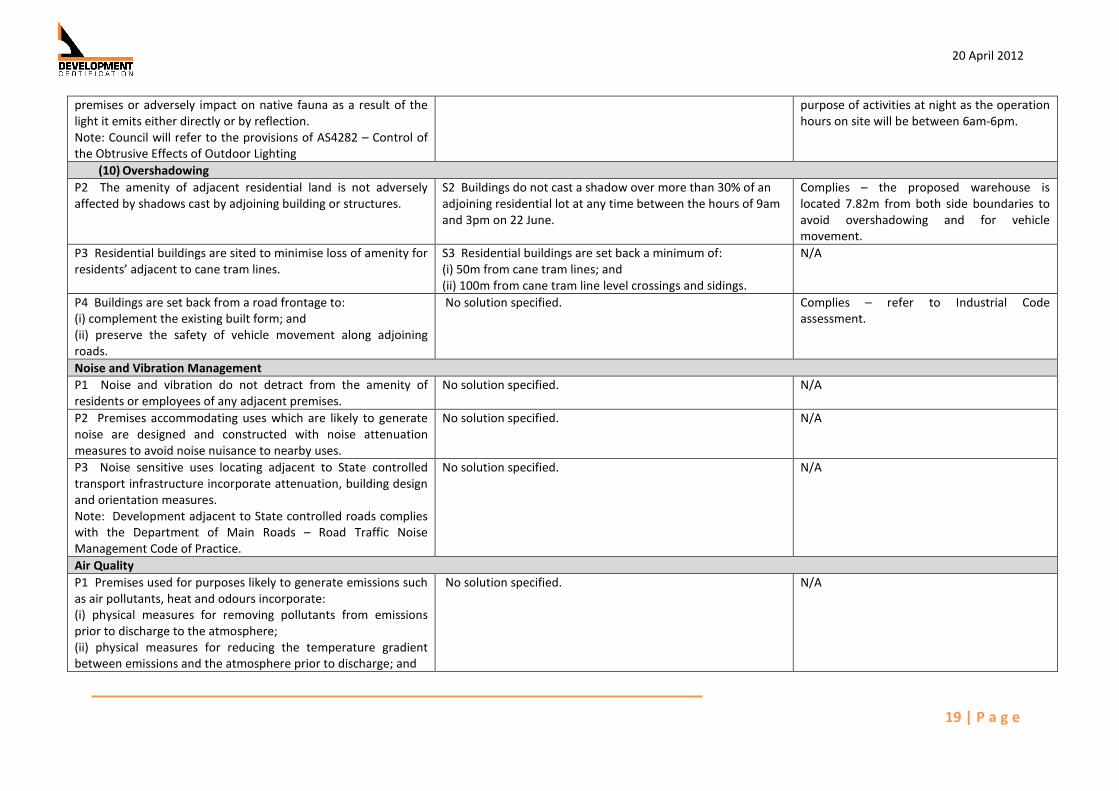
20 April 2012
19 | P a g e
premises or adversely impact on native fauna as a result of the
light it emits either directly or by reflection.
Note: Council will refer to the provisions of AS4282 – Control of
the Obtrusive Effects of Outdoor Lighting
purpose of activities at night as the operation
hours on site will be between 6am-6pm.
(10) Overshadowing
P2 The amenity of adjacent residential land is not adversely
affected by shadows cast by adjoining building or structures.
S2 Buildings do not cast a shadow over more than 30% of an
adjoining residential lot at any time between the hours of 9am
and 3pm on 22 June.
Complies – the proposed warehouse is
located 7.82m from both side boundaries to
avoid overshadowing and for vehicle
movement.
P3 Residential buildings are sited to minimise loss of amenity for
residents’ adjacent to cane tram lines.
S3 Residential buildings are set back a minimum of:
(i) 50m from cane tram lines; and
(ii) 100m from cane tram line level crossings and sidings.
N/A
P4 Buildings are set back from a road frontage to:
(i) complement the existing built form; and
(ii) preserve the safety of vehicle movement along adjoining
roads.
No solution specified. Complies – refer to Industrial Code
assessment.
Noise and Vibration Management
P1 Noise and vibration do not detract from the amenity of
residents or employees of any adjacent premises.
No solution specified. N/A
P2 Premises accommodating uses which are likely to generate
noise are designed and constructed with noise attenuation
measures to avoid noise nuisance to nearby uses.
No solution specified. N/A
P3 Noise sensitive uses locating adjacent to State controlled
transport infrastructure incorporate attenuation, building design
and orientation measures.
Note: Development adjacent to State controlled roads complies
with the Department of Main Roads – Road Traffic Noise
Management Code of Practice.
No solution specified. N/A
Air Quality
P1 Premises used for purposes likely to generate emissions such
as air pollutants, heat and odours incorporate:
(i) physical measures for removing pollutants from emissions
prior to discharge to the atmosphere;
(ii) physical measures for reducing the temperature gradient
between emissions and the atmosphere prior to discharge; and
No solution specified. N/A

20 April 2012
20 | P a g e
(iii) operational systems, including monitoring systems for major
industry and major infrastructure, which maintain emissions
within ANZECC guideline standards.
Flooding
P1 Premises subject to risk of inundation or damage through
flood are provided with immunity to that risk in order to reduce
potential property damage and to ensure public safety.
S1.1 Development is sited on land that would not be subject to
flooding during a DFE; or
S1.2 For development comprising a residential element, the
floors of all habitable rooms are located 300mm above the
DFE; or
S1.3 For non residential development or development
involving temporary or moveable residential structures (e.g.
caravan parks):
(i) buildings are located and designed so that floor levels
(except areas used for car parking) are 300mm above the DFE;
or
(ii) there is at least one evacuation route that remains passable
for emergency evacuations during all floods up to and including
the DFE.
26 Heidi Street is located within the Flood and
Inundation Management Overlay.
The subject site has an estimated 100 year
ARI flood level of RL5.01AHD. The ground
level of the site is estimated at RL 6m-6.75m
AHD (Appendix 7).
Therefore complies as the development is
located about the 100 year ARI Flood Event.
P2 There is no increase in the number of people living or
working on a flood prone site, except where the premises are
occupied on a short term or intermittent basis.
No solution specified. N/A
P3 Development does not result in adverse impacts for the
safety of people or the capacity to use land within a floodplain
and does not involve:
(i) Any physical alteration to a watercourse; or
(ii) Net filling of 50 cubic metres; or
(iii) The proposed works either:
(A) avoid any reductions of on-site flood storage capacity and
contain within the subject site any changes in
depth/duration/velocity in flood waters of all floods up to and
including the DFE; or
(B) do not change the flood characteristics at the DFE outside
the subject site in ways that result in:
- loss of flood storage;
- loss of / changes to flow paths;
- acceleration or retardation of flows; or
No solution specified. N/A

20 April 2012
21 | P a g e
- any reduction of flood warning times elsewhere on the
floodplain.
P4 Storage and handling of hazardous substances on sites that
are subject to risk of inundation or damage through flood,
ensures that persons and property are not placed at
unreasonable risk.
S4 Storage or handling of substances that may be a hazard to
the environment or human safety by the risk of contamination
due to flooding:
(i) is undertaken in accordance with a risk assessment; and
(ii) provides for the storage of any hazardous substances above
or securely isolated from the DFE level.
N/A
P5 The use is designed to minimise the impact of Cyclonic
Hazards
No solution specified. Complies – controlled by the BCA.
(11) Undefined Flood and Inundation Areas
P6 Where flood limits are not identified, development is
undertaken such that there is no adverse affects on flood levels
or flows on the site or up-stream and down-stream of the site
No solution specified. N/A
Water Quality
P1 Development does not detract from the maintenance of
water quality in the City’s watercourses and bulk water storages,
in particular its:
(i) environmental values; and
(ii) where applicable, potability of the water supply.
No solution specified. Complies – refer to Preliminary Site Service
Layout (Appendix 5).
P2 Premises incorporate:
(i) physical measures for intercepting and treating surface water
drainage and spilled substances prior to their release to the
watercourses; and
(ii) bunding of sites or areas within sites or integrated drainage
systems which include waste water treatment measures, where
chemicals, fuels, lubricants or other soluble pollutants are being
handled or stored.
Note: Council will refer to the Environmental Protection
Policy (Water) 1997
No solution specified. Complies – refer to Preliminary Site Service
Layout (Appendix 5).
P3 The City’s groundwater resources and surface waters are
maintained by:
(i) providing a stormwater system that manages stormwater
quantity and quality prior to discharging into receiving waters;
(ii) providing non structural source control measures;
(iii) providing structural source control measures;
No solution specified. N/A

20 April 2012
22 | P a g e
(iv) retaining or rehabilitating natural waterway corridors such as
natural channels, wetlands and riparian vegetation;
(v) providing storage of waste water in secure and sealed storage
facilities;
(vi) ensuring efficient disposal areas and ground and surface
water retrieval areas are buffered from each other;
(vii) ensuring that contaminants do not enter the groundwater
resources; and
(viii) with reuse of reclaimed water, ensuring safe treatment and
disposal of contaminated water.
P4 The biodiversity and habitat values of coastal areas and
associated estuarine systems are protected from:
(i) increased nutrient or sediment levels; or
(ii) changed flow, inhibited passage, or hydrologic regimes of the
natural coastal and marine margins, which may result from
development.
No solution specified. Complies – refer to Preliminary Site Service
Layout (Appendix 5).
P5 Sediment and nutrient loadings into a watercourse are
minimised through:
(i) treated on-site effluent;
(ii) adequate stormwater run-off controls; and
(iii) on-site and off site erosion and sediment controls.
No solution specified. Complies – refer to Preliminary Site Service
Layout (Appendix 5).
Erosion and Sediment Control
P1 Minimisation of the risk of erosion and sedimentation either
on-site or elsewhere, by a comprehensive approach to soil
erosion control and sedimentation management, including:
(i) the minimisation of:
(ii) earthworks;
(a) clearing of land;
(b) long term stockpiling of excavated materials;
(iii) use of appropriate construction management techniques;
(iv) diverting surface water drainage around disturbed areas; and
(v) treating and removing sediments from stormwater over
disturbed areas prior to release from the site.
S1 The control of Erosion and Sedimentation complies with
Planning Scheme Policy 15.07 - Engineering Design Guideline
D7 Soil and Water Quality Management.
Complies - apart from the proposed
landscaping the whole site is to be sealed
with hardstand therefore erosion and
sedimentation will not be an issue.
P2 Progressive rehabilitation of disturbed areas occurs within the
site through a comprehensive rehabilitation program including:
(i) the grading and reshaping of the disturbed areas to provide
No solution specified. N/A

20 April 2012
23 | P a g e
controlled and stable drainage flow paths;
(ii) the construction of drainage paths which divert high velocity
flows away from disturbed areas;
(iii) the re-spreading of stored top soil stripped from the site; and
(iv) the planting of the disturbed area with native species of
grasses, ground covers and trees.
Coastal Management
N/A N/A N/A
(12) Erosion Prone Areas
N/A N/A N/A
High Impact Activity Areas
N/A N/A N/A
(13) Landscaping for Outdoor Vehicle Parking Areas
P8 Landscaping for outdoor vehicle parking areas, where
development is for the purposes of Accommodation units,
multiple dwelling units, Sport and recreation, indoor
entertainment, outdoor entertainment, child care centre, service
station, motel, Industrial uses and retail or commercial uses, will:
(i) visually enhance the area along any road frontage;
(ii) screen the area from any adjoining residential or other
sensitive uses;
(iii) provide visual relief and shade throughout the area; and
(iv) be compatible with local native species.
S8.1 Landscaping of outdoor vehicle parking areas provides
planting of trees and shrubs:
(i) in a strip 2m wide along any primary road frontage at a
density and a scale appropriate to the size of the vehicle
parking area and the function of the adjoining road; and
(ii) in median areas throughout the vehicle parking area at a
rate of 1 shade tree for every 6 parking spaces.
S8.2 Provide a wall, fence or continuous screen planting, to a
height of at least 1.8m along any boundary to land used or
likely to be used for residential or other sensitive use.
Complies – There is a landscaping strip along
the road frontage and there are only 5 car
parking spaces proposed.
(14) Landscaping – General Requirements
P9 Landscaping is designed and established to:
(i) an appropriate scale relative to both the street reserve width
and to the size and nature of the development;
(ii) incorporate remnant vegetation, where possible;
(iii) provide summer shade and shelter for
pedestrian comfort and energy efficiency of buildings;
(iv) maximise areas suitable for on-site infiltration of stormwater;
(v) allow for pedestrian and vehicle safety;
(vi) generate a cohesive and distinct visual character for the
streetscape and locality;
(vii) be suitable to the tropical climate;
No solution specified. To Comply – a detailed landscape plan will be
designed once approval of the use as been
given by the assessment manager. The
applicant requests the assessment manager
provide appropriate and relevant conditions
relating to the requirement of a landscape
plan.

20 April 2012
24 | P a g e
(viii) provides planting, paving and other landscape treatment
according to a Landscaping Plan; and
(ix) minimise irrigation requirements through appropriate plant
selection, mulching and water efficient irrigation systems.
Note: The Landscape Planning Scheme Policy should be referred
to for information that may be required by Council to assist in
assessment of an application.
(15) Vegetation Management
P10 Natural vegetation is maintained wherever possible.
Note: Assessable development being operational work that is
clearing of native vegetation of freehold land consistent with
Schedule 8, Part 1, 3A of IPA will be assessed under the
provisions of the Vegetation Management Act 1999 and the
State code for clearing of vegetation on freehold land.
No solution specified. N/A – site is cleared.
Community Safety Design Principles
(16) Surveillance and Sightlines
P1 Premises provide opportunities for informal surveillance from
surrounding buildings and land uses.
Note: Ways of showing compliance are as follows:
(i) Windows in buildings overlook pedestrian routes, open space
areas and carparks.
(ii) No blank building facade is presented to any street frontage.
(iii) Street level windows are provided in buildings fronting onto
public spaces and movement routes.
No solution specified. Complies
P2 Where located adjacent to public areas, premises are
designed to permit surveillance of public areas.
No solution specified. N/A
P3 Buildings and street addresses in urban areas are easily
identified.
No solution specified. Complies
P4 Premises for uses other than dwelling houses and dual
occupancy, are illuminated at night to:
(i) maximise personal safety of site users; and
(ii) minimise opportunities for attack by hidden persons.
(iii) provide lighting along access routes, in building entrances,
site entries, car parking areas and other movement areas used
after dark.
No solution specified. N/A – the site will not be in operation after
6pm at night.

20 April 2012
25 | P a g e
P5 Visibility is provided into stairwells, elevators, car parks,
lobby entrances and bicycle parking facilities.
No solution specified. N/A
P6 Premises and their surrounds do not include:
(i) ‘blind’ corners (including on stairs, in corridors or other
situations where movement can be predicted);
(ii) sudden changes of grade on pathways which reduces
sightlines;
(iii) concealment spots (unless they can be secured after hours);
and
(iv) pedestrian tunnels, excepting that where unimpeded
sightlines or the absence of concealment points cannot be
reasonably achieved, equipment (such as security mirrors) and
good lighting is provided to enhance visibility.
(v) Potential concealment areas (i.e. dead-end alleys) are
restricted or locked after hours.
(vi) Where a concealment spot is unavoidable, there are aids to
visibility such as convex mirrors and good secure lighting.
(vii) Concealment spots such as:
(A) dark areas adjacent to a main/designated pedestrian
routes;
(B) private dead-end alleyways;
(C) indentation in fencing or walls;
(D) gaps in the streets such as entrances to interior courtyards
and recessed doorways; and
(E) areas that are isolated after dark; are not located on the
premises.
No solution specified. Complies
P7 Building entrances:
(i) are clearly defined;
(ii) are well lit and face the street;
(iii) do not create concealment spots;
(iv) provide clear sightlines from the building foyer so that
occupants can see outside before leaving the building;
(v) have lobbies visible from the exterior; and
(vi) have staff entrances, if separate, which are well lit and
maximise opportunities for informal surveillance and for clear
sightlines.
No solution specified. Complies

20 April 2012
26 | P a g e
P8 Landscaping is designed and maintained to provide informal
surveillance and clear sight lines on accessways and to other
public spaces.
S8 “Vulnerable premises” provide landscaping designed to
promote safety including:
(i) planting which does not obscure doors and windows
overlooking public spaces and isolated areas;
(ii) shrubbery and low-level planting associated with footpaths
which does not exceed 0.5m in height where abutting
pavements;
(iii) trees in vulnerable settings which do not have branches
below 1.5m; and
(iv) hard landscaping elements such as low fencing and walls
(below 1.2m) which guide pedestrians and vehicles along
designated paths.
To Comply – a detailed landscape plan will be
designed once approval of the use as been
given by the assessment manager.
(17) Safe Movement and Access
P9 The design of premises provides for unimpeded sightlines,
particularly along pedestrian and bicycle routes.
S9 All barriers (including landscaping features) along bicycle
and pedestrian routes are visually permeable (i.e. can be easily
seen through to reduce concealment points).
N/A
P10 Car parking areas are:
(i) designed to optimise informal surveillance and illumination,
and to minimise unlawful access;
(ii) well lit to enable visibility of all external edges and routes
providing access to the car park;
(iii) designed to minimise instances of large numbers of cars
being co-located (over 100 cars in a single block). If more than
100 cars, more than one entry / exit point is provided so that the
car park does not become an entrapment area.
No solution specified. Complies – refer to Vehicle Movement Plan
P11 Underpasses and overpasses are designed and located to
reduce opportunities for crime, so that:
(i) pedestrians are able to see what is in an underpass or tunnel
and at the end of it before entering; and
(ii) signs at each end of an underpass indicate where it leads and
an alternative route to use at night.
No solution specified. N/A
P12 Underpasses are wide enough to accommodate both
pedestrian and cycle traffic, (Note: Council will refer to the
provisions of AUSTROADS Guide to Traffic Engineering Practice
Part 14- Bicycles). ]
No solution specified. N/A
P13 The design and location of laneways and alleyways S13.1 Laneways are straight and have more than one entrance. N/A

20 April 2012
27 | P a g e
promotes community safety. S13.2 Unnecessary access to buildings from laneways is
avoided.
(18) Building Design and Lighting
P14 Buildings contribute positively to the enhancement of public
safety and security.
S14.1 Ramps and elevator entrances are located in areas
which are not isolated.
S14.2 Lifts are located within a secure entrance, and
incorporate graffiti and vandal-resistant measures (i.e. a fully
glazed and enclosed vestibule area at the exit to the lifts).
S14.3 Loading and storage areas are well lit or can be locked
after hours.
S14.4 Parking spaces are allocated near the building entry for
employees working after hours.
S14.5 Enclosed or underground car parks can only be accessed
from inside the building or through a security system.
S14.6 All windows, particular those at street level are secure,
without creating a ‘fortress-like’ appearance (i.e. avoid solid
roller shutters).
Complies
P15 Lighting is provided which:
(i) increases safety and security in and around the premises;
(ii) considers vegetation, in both its existing and mature forms, or
other elements that may have the potential to block out light;
(iii) illuminates inset spaces, access/egress routes car parking
areas and signage; and
(iv) supports visibility for pedestrians, as well as road users.
S15 No specific solution.
Note: Council will refer to the following as guidance in
assessment of compliance:
Security lighting is consistent with Australian Standard S 4282
(1997) (The Control of Obtrusive Effects of Outdoor Lighting.
Lighting of pedestrian and bicycle movement routes, public
spaces and outdoor signage in public spaces is to the minimum
Australian Standard of AS1158 (Public Lighting Code).
Complies

20 April 2012
28 | P a g e
3.5. Planning Assessment against Overlay Codes
The site of 26 Heidi Street Paget is located within both the Flood and Inundation Management
Overlay and the Development in the Vicinity of Mackay Airport Overlay.
3.5.1. Flood and Inundation Management Overlay Code
In reply to the request for assessment against Flood and Inundation Management Overlay Code for
the proposed Warehouse at 26 Heidi Street Paget, the following response has been prepared. The
response refers to the Flood and Inundation Management Overlay Code and note that the proposed
Warehouse is in accordance with the code.
The Flood and Inundation Management Overlay only impacts a very small section along the back
boundary of 26 Heidi Street. Appendix 7 provides evidence of the 100 year ARI flood event level
being RL 5.01m AHD and the natural ground level is between RL 6m-6.75m AHD. Therefore a
combination of a naturally high ground level and only a small amount of the property being located
in the Flood and Inundation Management Overlay Code, the proposed Warehouse is in compliance
with the Flood and Inundation Management Overlay Code.
Flood and Inundation Management Overlay at 26 Heidi Street

20 April 2012
29 | P a g e
3.5.2. Development in the Vicinity of Mackay Airport Overlay Code
The site is located within 0 to 3km of the Mackay Airport and is located in the Airport Obstacle
Limitation Surface area. The proposed Warehouse use does not trigger code assessment against
this Overlay Code.
4. CONCLUSION
The proposed spare parts Warehouse development at 26 Heidi Street has been designed
with consideration to the limitations of the site; existing infrastructure; surrounding
properties; and the requirements for the use to function successfully on site. The proposed
Warehouse is in compliance with the relevant codes of the Mackay City Planning Scheme
2006. From the provided information in this report and attached documentation it is
requested the assessment manager consider this application to be properly made and
consequently approval of the use.

20 April 2012
30 | P a g e
5. APPENDICIES
Appendix 1 ...................................................................................... IDAS Forms
Appendix 2 ............................................................... Owner’s Letter of Consent
Appendix 3 ...................................................................................... Site Photos
Appendix 4 .......................................................................... Streetscape Photos
Appendix 5 ......................................................... Proposed Development Plans
Appendix 6 ............................................................... Aerial Photography of Site
Appendix 7 ........................................................... 1Year ARI Flood Level of Site